
WATER TERRAINS
Washed by the waters of the Detroit River, Belle Isle is a large public park and an important part of the cultural and social landscape of the Detroit metropolitan region. Building on its insular condition, the opportunities for interaction with water in the park are a key unifier to a variety of demographics that seek access to nature in the urban confines. Lakes, canals, wetlands and marshlands, fishing piers, marinas and a beach make Belle Isle a space of wonder and discovery through unmatched public access to the Detroit River. Yet, water carries important traces of the postindustrial regional condition and serve as a continuous reminder for the expected impacts of climate change. As one of the bi-national areas of concern in the Great lakes, water pollution remains a pressing issue in the ecological recovery of the region. Habitat restoration and remedial efforts for improved water quality are crucial to the overall health and prosperity of the island’s ecosystems. On the other side, more intense precipitation results in recurring flooding and loss of access to the large segments in the island.
abstract
NISWI-MISHKODEWINAN (THE COUNCIL OF THREE FIRES)

W01 WATER TERRAINS
sacred waters ANISHINAABE POTOWATOMI
To the Niswi-mishkodewinan or Council of Three Fires (Anishinaabe, Potowatomi, and Odawa) the Great Lakes region was an end to a long prophetic journey. The shores of the Great Lakes and Belle Isle symbolized sustenance with the region’s wild rice (Mnomen). The water itself also sacred, is tied to creation and the feminine. To these peoples the Belle Isle and the Detroit River meant the beginning and future.


ODAWA

WATER
W02 WAHNABEZEE Image Courtesy of Apprend.io
TERRAINS
colonial legacies
Prior to the arrival of European settlers, Belle Isle and the river watershed was rich in biodiversity and abundance.
known as Pontiac’s Rebellion, where regional tribes banded together against European Settlers.
Through exploration and trade
the French and English exploited indigenous hospitality and facilitated destabilization through the trades of firearms, alcohol, and religion
Within that time, the French took the island from the Odawa and Chippewa, to protect their hog livestock. This lead to the French name of the island as Ile ax Cochons (Hog Island).
The European settlers divided various rival cultures and utilized them to fight wars over territories and resources. The injustices crescendo towards the event
After, the land was utilized for agriculture before being purchased by the city of Detroit and transformed into the park it is today.
BUILDING GROUND
Key: 1873 Recorded Island Extent 1883 Island Lake Extents 0 1mi
1km
W03 WATER
TERRAINS
economic value
With the arrival of European Settlers the Detroit River Watershed and Island meant economic power, protection, and abundant resources. The region was exploited for fur, trade, and the manufacturing of steel and automobiles. Over time the symbolism of the sacred region shifted from one of creation to production, resource extraction, and consumption.
as a new paradise for the city of Detroit. The plan included the dredging of canals, expansion of lakes, and creation of open fields.
Later in the 1910’s other topographical changes included the lower tip of the island and Blue Heron Lagoon.
The Belle Isle of 1873 was much different in shape than the one today. The City’s commissioned Olmsted to re-imagine the island
LAKES AND CANALS
W04 WATER TERRAINS
1 1 2 2 3 3 4 4 5 5 6 6 7 7 0 1mi 1km
Key:
Lake Tacoma Lake Okonoka Blue Heron Lagoon Lake Muskoday Loop Canal Nashua Canal Sylvan Canal
aqua landscapes
Belle Isle is comprised of 4 large bodies of water, Lake Tacoma, Lake Okonoka, Lake Muskoday, and Blue Heron Lagoon. Each of these are connected through a 3 canals: Loop, Nashua, and Sylvan that stretch from the south to north end of the island.
Historically the island’s aquascape ran against the direction of the Detroit River. This allowed the water to drain into both Lake Muskoday and Okonoka.

COASTAL SHORELINES
Key: Beach Condition
Hybrid shores Condition
Seawall vista Condition
1km
1mi
W05 WATER
TERRAINS
0
littoral constructiveness
Belle Isle contains 7 miles of various coastal shorelines that are broken down into 3 degrees of varying constructiveness.
The three are seawall vista, beach, and hybrid shores that facilitate different levels of pedestrian and wildlife engagement. Many of the coastal conditions are under threat of severe erosion and degradation. These issues stem from excessive waves caused by large nautical vehicles from increased water level.
hybrid shores
12% 06% 82% seawall vista beach
WATER
W06 VISTA
TERRAINS
a place to be
The seawall vista shoreline is a condition that allows visitors to engage in different recreational activities, such as: sightseeing, fishing, lounging, and walking.
The built conditions of the Vista Shoreline include paved walkways followed with a 1 to 1 cut towards the water. There is always a guard and handrail to rest upon, accompanied with benches and tables.

WATER
W07 BEACH
TERRAINS
a place to swim
The beach condition is only found in one location on the Northwest shore of the island. Here, visitors can relax, swim, and play. It draws large amounts of people from the Detroit region, and is where many demographics interact.
The condition include sand fill with a gentle slope towards and into the river. There is minimal pavement.
HYBRID SHORES

W08
WATER TERRAINS
register water flow


The hybrid shoreline is the most dominant condition on the island. It presents evidence of erosion mainly in the areas facing the Detroit River Canal. Activities are limited in these areas due to lack of access, but one can walk up and see a view of the river.
The semi-built conditions include remedial efforts to decrease erosion, made up of discarded concrete and rocks. Additionally, the vegetation at the transition between water and land creates soft buffers. Hybrid Shores are not for recreation and are dangerous.

INLAND SHORELINES
Key: Vernal Pools Condition
Canals Condition
Lakeshores Condition 0 1mi
1km
W09 WATER
TERRAINS
internal waterscapes varies
The inland shorelines of Belle Isle are broken into 3 conditions of varying constructiveness. They include Vernal Pools, Canals, and Lakeshores. There are over two miles of canals and 106 acres of water on the island.
vernal pools
54%
Before the Olmsted’s plan, the lakes of Belle Isle existed at various extents. Through his vision, the lakes grew and canals were dredged connecting the various inland water bodies.
canals
46%
lakeshores

WATER
W10 VERNAL POOLS
TERRAINS
Image Courtesy of Michigan DNR
a place to thrive


Found throughout Michigan’s marshy environments and Belle Isle, Vernal Pools are a collection of seasonal shallow pools of water that are a host of rare flora and fauna. On Belle Isle they are mostly found in the Wet Mesic Forests between Lake Okonoka and Muskoday.
A temporal condition, they are full in seasons of flooding and usually dry up during summer. Therefore their extents can be difficult to measure.
CANALS

W11
WATER
TERRAINS
a place to paddle
On the island there are over two miles of combined canals that connect the large lakes from West to East. They are the Loop, Nashua, and Sylvan Canals.
Together they provide both habitat for the flora and fauna of the island and drainage for larger lawn areas.


In a human sense, the canals provide safe harbor for various water activities such as paddle boarding and kayaking.
The canal condition is semi constructed.
LAKESHORES

W12
WATER
TERRAINS
a place to learn

The lakeshore condition is found inland and stretches into canals. This allows visitors to safely kayak, paddle board, walk, and at many points in the island to learn about the different aquatic habitats. The marshy conditions of Belle Isle have served as pollutant filters of storm water runoff where willow trees are monumental keepers. The ability to fish is reduced due to previous damming practices. The conditions include stagnant or slowly moving water, marshy and low slope transition, with high amounts of vegetation.

Key: Fishing Sites
Swimming Beach
Paddling
Watercraft Rentals
Model Boat Basin
W13 WATER TERRAINS
RECREATION
0 1mi
Detroit Boat Club Detroit Yacht Club
1km
options
Belle Isle boasts a variety of aquatic activities, from fishing, swimming, paddling, renting watercraft, to just walking down the river.
While the island presents itself as public park, the water access is not always accessible. Organizations like the Detroit Yacht Club are incredibly exclusive, and renting equipment for water sports can be expensive.

Key: Severe Erosion
Moderate Erosion
Mild Erosion
South Pier Breakwaters
1km
1mi
W14 WATER TERRAINS
EROSION
0
shifting shores effects have included longer bouts of flooding that have become more frequent.
Erosion on the shores of Belle Isle is a constantly shifting condition. The continual passage of cargo ships along the Eastern coast of the isle produces disturbances that batter the shoreline. This has prompted much of the waters around Belle Isle to be listed as a no-wake zone to decrease the potential for more severe impact. Shoreline erosion is accompanied with a loss in Coastal Wetlands, incubators of the region’s biodiversity. Other negative
In addition to that the decadal cycles of the Great Lakes water elevations has a profound impact on the island’s shoreland. Such as submerging and revealing amphibian ecosystems.

WATER
W15 EROSION
TERRAINS
quick fix
The Department of Natural Resources and Friends of the Detroit River have inadvertently engaged through ad hoc management and lack of proper investment, different methods of alleviating erosion. These remedial efforts although helpful in their small scale, are concentrated to restoration areas. Those methods include the use of broken concrete and heavy rip rap breakwaters, not conducive to an engaging or inviting natural environment.

POLLUTION
Key: Metal Cluster Sample Locations
Belle Isle Remedial Areas
1km
0 1mi
W16 WATER
TERRAINS
the rivers economies or recreational memory for the riverfront communities. Even with regulations in place, the legacy of heavy metals in the river soils remains.
Washed by the waters of the Detroit River, Belle Isle has experienced the changing nature of the river waters. The Detroit River enabled the rediscovery of the region and its progressive colonization. From water supply, trade, manufacturing, and fishing, the river has been exploited since the Industrial Revolution. The automobile and steel manufacturing plants discharged untreated byproducts back into the river, which lead to mass die offs, odor, and illness, and the detachment from any joyful
Agricultural byproducts have also leached into the river causing fluctuations in water chemistry. And last, an outdated combined sewage system turns heavy rainfall into outfall events with millions of gallons of untreated water and e.coli outbreaks around the waters of Belle Isle.

W17
WATER TERRAINS
POLLUTION
sewage and outbreaks
The Detroit region like many, utilize a combined sewage system that mixes both runoff with municipal sewage. In events of high water the system has a safety feature called a CSO (Combined Sewage Overflow) that in periods of flooding expels billions of gallons of untreated sewage into the Detroit River.
Climate change and increasingly turbulent summer weather patterns have increased breakouts and their durations.
Other factors that contribute to lower water qualities around the Belle Isle include geese fecal matter and discharges from passing boats, and enduring remnants of the industrial age
With the heavy rainfall of last summer, untreated wastewater was discharged leading to e.coli outbreaks that closed many parts of the river, including the Belle Isle Beach.
Overall this has had an impact on various recreational activities from swimming to fishing.
CLIMATE CHANGE
Key: 2020 Flooding Area 0 1mi
1km
W18
WATER
TERRAINS
flooding
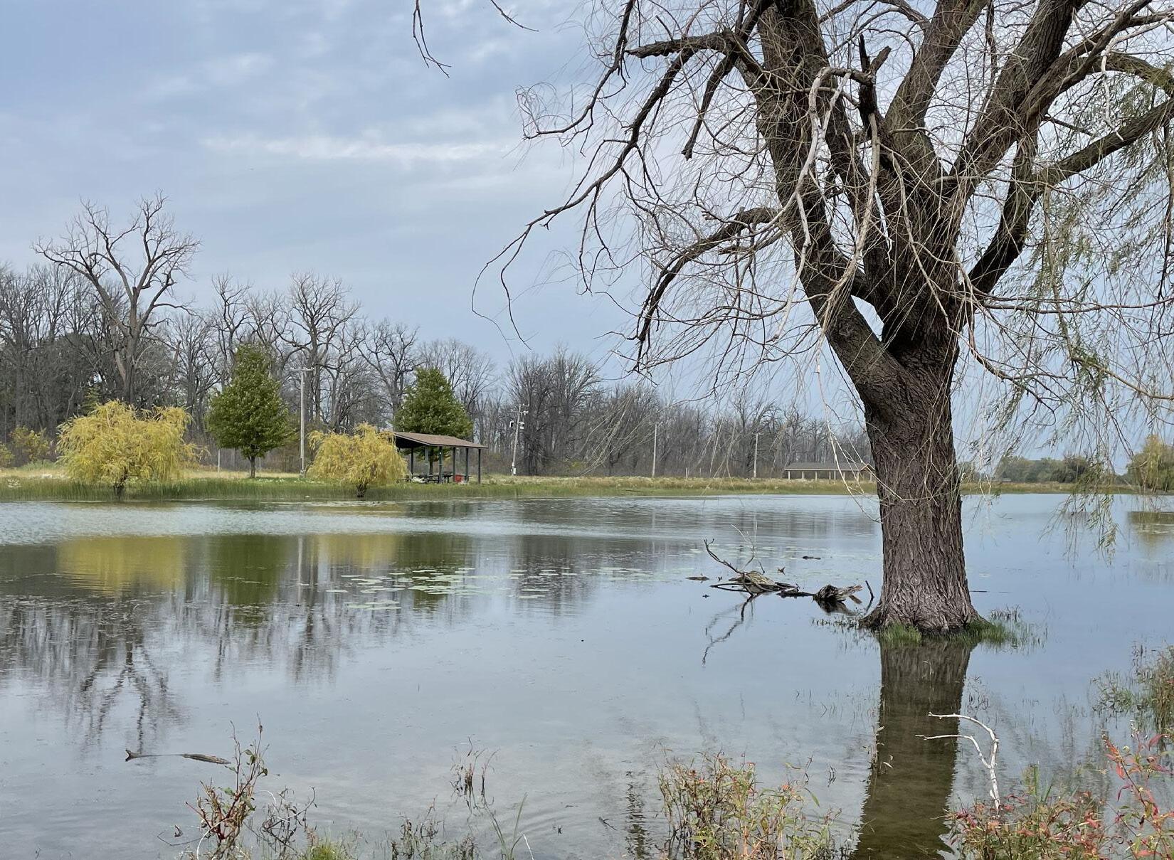
Fluctuating water levels, more intense precipitation, and manmade development have put the island flora and fauna habitats at risk.
The impacts of recurrent flooding vary from reduced access to loss of mature trees in the wet-mesic flatwoods forest, one of the most precious ecosystems in Belle Isle. Evolving conditions will require continued management of the landscapes and underlying infrastructures.

CLIMATE CHANGE
W19
WATER
TERRAINS
changing tides
Naturally the currents of Belle Isle flowed inversely against the direction of water upward into the two of the Island’s larger lakes.
This created a unique environment that cultivated the island’s natural forests.
With the newer projects of water redirection and drainage, this has impacted the island’s natural ability to drain excess water. Ultimately leading to mass tree death.

Key: Restoration Areas
RESTORATION
W20 WATER TERRAINS
0 1mi 1km
aquatic habitats
The Department of Natural Resources paired with the Friends of the Detroit River have engaged to restore habitats and promote biodiversity.

Their projects have focused on three area around the island: The Breeding reefs just north of the Island, Blue Heron Lagoon, and the South Fishing Pier.
painted turtle
 lake sturgeon


W21
REEFS WATER TERRAINS
man-made replacements
The Breeding Reefs create safe and stable shelter in a part of the river that is heavily dredged. In doing so they have encouraged Sturgeon spawning.
lake sturgeon


WATER
W22 LAGOON
TERRAINS
good intentions
Next, the Blue Heron Lagoon restoration project created emergent wetlands that served as both breeding grounds for the river’s turtle’s and flood water mitigation.
While this project had great intentions and promising predictions, unfortunately record rainfalls and flooding, in combination with these new inlets into the island, caused the oversaturation of the island and the subsequent tree death.
painted turtle

FISHING PIER

W23
WATER
TERRAINS
repaired shoreline
Lastly, the South Fishing Pier project focused on fish habitat restoration and erosion prevention. Emergent and submerged wetlands provide shelter, while breakwaters alleviate strong waves.


large mouth bass
bluegill
