3 minute read
Kenilworth floods 1972-2022


KENILWORTH FLOODING 1972 - 2022
Since the subdivision and sale of the Kenilworth township blocks in 1921 flooding has been a problem for residents.
Advertisement
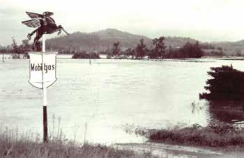
1950s Mobil's 'Flying Red Horse', Kenilworth 2022 February

2022 February by Snr Constable Pierre Senekal.
The photographs indicate that little has changed to the threat of inundation in the past 50 years. The picture with the sign of the “Flying Red Horse” was taken in the 1950s when McGaws Garage was situated where Boxsells shed now stands. The photograph to the right shows that, even with the growth of trees along the roadside, flood waters still come as high in the 1999 flood.
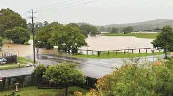
The bottom two photographs of the flooded land below George Street show how easily the river becomes part of the township in flood periods. Thanks to our policeman Pierre Senekal for sharing his photographs of the 2022 flood.
It is better to have such items and not need them than to need them and not have them.

2022 February - Elizabeth & Charles Sts

1999 9 February - Elizabeth St 11.9m flood by David Pearson
1999 9 February - Brooloo Rd 11.9m flood by David Pearson

1999 9 February - Mary Rr Bridge 11.9m flood by David Pearson
2022 February - Elizabeth & George Sts

1972 12 February - Cnr Elizabeth & George Sts 11.58m flood
The support by this community of the Kenilworth Museum over the past twelve months has been greatly appreciated. Merry Christmas and a Happy New Year 2023 to all.
Lenore Meldrum, President Kenilworth & District Historical Assoc. Inc.

RAINFALL MOY POCKET – NOVEMBER 2022
Rain fell on 13 days, average 11 days. Total rain for three months of Spring 355mm. Last Spring 383mm. Average for Spring 227mm. Total rain for 11 months 2499mm. Previous wettest January-November was 2013, 1434mm. Same period last year 1067mm. January-November average 1097mm. 12 months total end of November 2593mm. 20 year annual average 1196mm.
Rainfall for Moy Pocket 2022 kindly recorded by Graham Brennan.