MGS Secures State Funding
Introducing New Staff
WMU Hosts DOE Visit at MGRRE
Making Data Accessible through Scanning
Outreach and Education Activities
In Memory of Alan Kehew
Mapping Michigan
Core Stories
Highlights >>>
A Note from the Director
The Michigan Geological Survey (MGS) was established on January 26, 1837, the same day as Statehood was established, 196 years ago MGS is grateful for funding support from the Governor’s office, legislators, and the staff conducting regulatory and information needs to Michiganders. We all need to know more about geology, and now MGS can build on existing data to meet our growing resources needs.

THANK YOU!
John Yellich- Director
For more information go to https://wmich.edu/geologysurvey
https://wmich.edu/michigangeologicalrepository


Core Quarterly
MGS Secures State Funding
A Bright Future for the Michigan Geological Survey


With new funding, the Michigan Geological Survey at Western Michigan University can now address some critical environmental and resource needs in Michigan. The funding came about as Michigan’s regulatory and resource departments, including


“We are pleased to see a funded Michigan Geological Survey, which will help EGLE better protect the environment and the public. We look forward to their future support in the area of geologic review and research”
 A.Wygant State Geologist and EGLE OGMD Director
Environment Great Lakes and Energy (EGLE), Natural Resources (DNR), Agricultural and Rural Development (MDARD), Office of Great Lakes (OGL), Transportation (MDOT) identified local societal issues and current priorities that needed to be addressed by comprehensive geologic data and research. In addition to gathering new data, the Survey will rely on the State’s largest collection of geological samples and data preserved at the Michigan Geological Repository for Research and Education (MGRRE). The Repository is a key component of the Survey because those resources support water, energy, and climate change research, and they provide support for training the next generation of geoscientists. The Michigan Geological Survey now has a bright future because of the new annual funding.
Funding would not have been possible without the ongoing support from WMU, our legislators, EGLE, industry, and others who advocate for MGS and MGRRE!
Issue 1 Winter ‘23
in this issue >>>
Quarterly Updates from the Michigan Geological Survey
Introducing New Staff
With new funding, MGS is growing to meet our goals!
Autumn HaagsmaMGRRE Director, MGS Assistant Director
Autumn joined the team after nearly a decade of conducting Carbon Capture, Utilization, and Storage research at a top research and development company. She earned her M.S. in Geophysics from the University of Minnesota and B.S. in Physics and Geology from Central
Michigan University. She is a PhD candidate at Miami University and is completing her doctoral degree by year end. Mrs. Haagsma joined MGS/MGRRE with the goal to expand clean energy, carbon sequestration, and climate related research in Michigan, integrate geoscience with societal considerations, and conduct more mentoring, outreach and education.
Nathan Erber – MGS Senior Research Associate
Nathan (Nate) brings extensive experiences and skills to the team. Previously a senior geologist at EGLE, he focused on geologic oversight of corrective action and permitting activities for hazardous waste treatment, storage, and disposal facilities. Additionally, Nate worked at the Ohio Geological Survey where his primary role was mapping glacial geology. Nate earned his M.S. and PhD from Western Michigan
University in glacial geology. His research interests include glacial geology, geomorphology, environmental geology, and mentoring He will focus on mapping glacial geology throughout Michigan

Evangelia Murgia – MGS Hydrogeologist
Evangelia (Evie) is a hydrogeologist and project manager with more than three years’ experience working with MGS. She joins the team after managing a multi-phase project updating a statewide water well database and automating data analysis and mapping processes. She holds a M.S.

and B.S. in Earth Science and Geology from Western Michigan University. Her research interests include PFAS, mycoremediation methods, improving geoscience accessibility and diversity, and creating educational/training materials and videos. Evie teaches earth and environmental sciences at KVCC and volunteers for various outreach activities to raise public awareness of geoscience careers and issues.
Research Findings
>>>
Making Data Accessible through Scanning
An update on the USGS National Geological and Geophysical Data Preservation Program (NGGDPP)

WMU Hosts DOE Visit at MGRRE

We hosted a campus visit to showcase research by MGS, MGRRE, and the Department of Geological and Environmental Sciences. Visitors included the regional intergovernmental and external affairs specialist from DOE, legislative aids, and government relations representatives. We shared our research about PFAS, remote sensing, environmental applications of UAVs, carbonate sedimentology and energy, carbon sequestration, water resources, aggregates and energy and mineral resources. These talks showed the skills, passion, and valuable impact the work has on Michigan.
We’ve completed most of our tasks for our USGS NGGDPP grant that will wrap up in June 2023. Thanks to the seven hard working students trained by Jennifer Trout, we’ve scanned 2,128 core analyses, 2,930 thin sections, and have photographed 3,921 boxes of core (2,585 of which are viewable on ScholarWorks now). We will continue to photograph cores and upload those images as we progress through the next 3 years on this project, as a result of additional USGS funding. It is a lot of work, but it will provide the public, students, researchers, and industry free and easy access to our cores. Through this year’s NGGDPP grant, we also purchased and installed three bays of racking to increase our archival capacity. The project is led by William Harrison.

https://scholarworks.wmich.edu/mgrre/

Key Updates >>>
Showcasing MGS research results to DOE
Outreach and Education Activities

Sharing, educating, and engaging with children, students, legislators, industry, and communities.
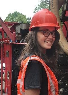
We are excited to welcome Marie Solum to our team as our new Outreach Coordinator. Marie will be developing new programming for our outreach and CoreKids. She will also help coordinate our visits to schools, museums, and science fairs. Marie is a member-at-large in the Michigan Earth Science Teachers Association and has prior experience in Environmental Consulting and as a K-12 teacher.
Subscribe to our YouTube Channel!
MGS established their YouTube channel with public release of educational videos on various topics within geoscience, including Michigan geology, wireline logging, water well drilling methods, core collection, and well installation. These are available along with instructional videos on how to use various services like the MGS Parcel Viewer Webapp and EGLE's Wellogic water well database. Subscribe and follow along!
https://www.youtube.com/@michigangeol ogicalsurvey/videos

The WMU geology club and MGS visited four schools including Comstock Elementary, Kalamazoo Schools, Otsego Elementary, and Stepping Stones Montessori, engaging 275 K-6 students. We also worked with the Kalamazoo Air Zoo on a cub scouts event engaging 17 K-6 students. In addition, Peter Voice attended the Michigan Science Teachers Association meeting to continue to develop teaching and education skills.
Upcoming Events
>>> Geological Society of America North-Central Section Meeting

Additionally, Peter Voice will guide a field trip to MGRRE, to tour the facilities, evaluate selected core, and then tour WMU’s Schmaltz Geology Museum and Dinosaur Park A Geomorphology Memorial session will be dedicated to Dr. Alan Kehew on Friday, May 5th .


MGS/MGRRE Plans to Attend the Following
MGS Goes to Capital Day
MGS and MGRRE staff traveled to Lansing to attend WMU’s Capital Day. We showcased our research projects to legislators and their aids.
MGS/MGRRE Presents Important
The team has been busy sharing and presenting our work to various Autumn Haagsma gave an introduction to CCUS and storage options in Michigan to EGLE. John Yellich presented on Michigan’s to the Michigan Soil and Water Conservation Society
Michigan’s Healthy Climate Conference April 11-12th Detroit, MI CCUS 2023 April 24-28th Houston, TX 2023 Michigan Environmental Justice Conference June 21-22nd Detroit, MI
Marie Solum with her family
In Memory of Alan Kehew 1947-2022
MGS Director 2011-2013
The Michigan Geological Survey was transferred to Western Michigan University (WMU) on October 11, 2011 and the Interim Director was Dr. Alan Kehew. Dr. Kehew was a glacial geologist, hydrogeologist and past Chair of the Department of Geology at WMU. Dr. Kehew was one of several people at WMU who were instrumental in presenting justification for the Survey to reside at WMU. They showed how the geology of Michigan was the foundation for identifying, assessing, and managing all of our geological resources, from the surface to thousands of feet below. Al Kehew will be remembered for his passion for geology, his mentoring of so many students and professionals, and his focus on the geology of the State of Michigan. Our team would like to dedicate this issue to Dr. Kehew and his contributions to the survey and university.


Dr. Kehew had an incredible journey in geology, starting with his Bachelors from Bucknell University. From there, he went on to Montana State to earn his Masters. He enlisted in the Navy shortly after and trained as a weather observer. Then, he completed his PhD at the University of Idaho in 1977. After completing his degree, Al worked at the North Dakota Geological Survey. In 1986, Al accepted a position in the Geology Department at Western Michigan University, where he remained for the next 34 years, moving from assistant to full professor and department chair from 1997 to 2002. His research continued to focus on hydrogeology and glacial geology. In the last 15 years, he mapped the glacial geology of several counties in Michigan. His research was published in numerous international journals, and he advised approximately 55 master's and PhD students at the two universities. He was elected to fellowship in the Geological Society of America for his research contributions and was awarded the Western Michigan University Distinguished Service Award in 2013. During his career, he wrote 4 editions of one textbook and one edition of another. One of the most rewarding projects in his career was an educational and cultural exchange collaboration with two Egyptian universities funded by the US State Department.
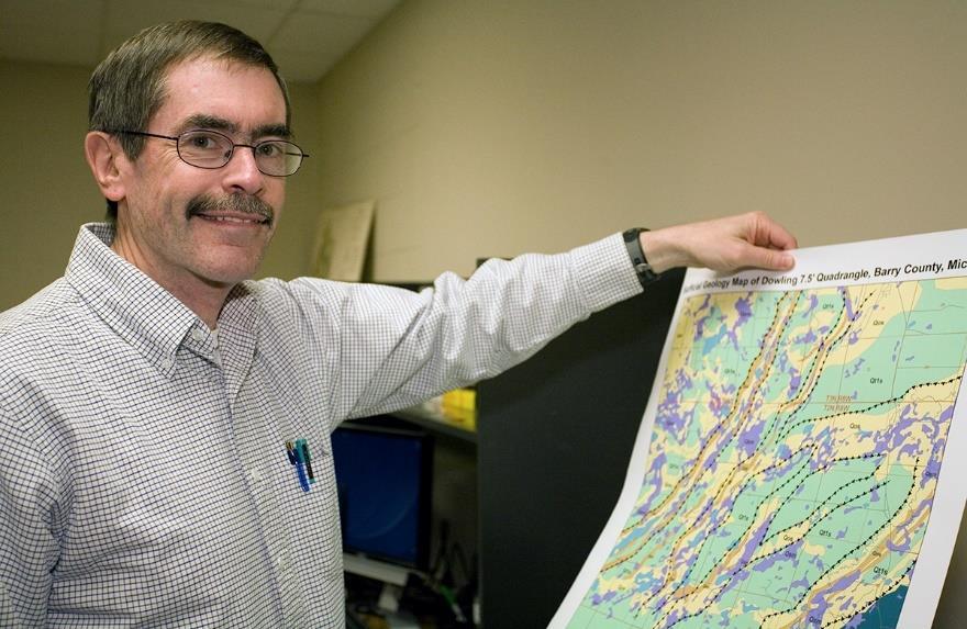
 Al Kehew and his map of Barry County
Al Kehew and students in the field
Al Kehew and colleagues collecting borehole samples
Al Kehew, Fred Upton, and John Yellich
Mapping Michigan Resources
In 2015, the Michigan Geological Survey undertook a detailed mapping of surface and subsurface geology to provide an assessment of the quantity, quality and distribution of resources such as groundwater, minerals, oil, natural gas, and aggregates that are the natural resource base for future economic investment.


The energy, construction, transportation and agriculture industries rely heavily on geological resources to maintain their economic viability and to spur new financial investment. Projects funded under this initiative will provide the necessary data to discover, develop, and sustainably manage existing and potential geological resources. Specifically, the initial phase of geologic mapping would target the essential areas of:
1. Resource assessment and distribution of sand and gravel for identification and protection of water resources and potential construction industry use
2. Carbon sequestration, oil and natural gas reservoir capacity and storage, and other energy storage
3. Mineral discovery and extraction opportunities including rare earths and critical minerals
Through applied technology and the benefits of a multi-disciplinary university, Michigan will benefit from the systematic acquisition of this critical mapping data. Issues of infrastructure, energy availability and natural resource discovery and use will remain a strategic element of Michigan’s economic base well into the future. Appropriately resourced, the Michigan Geological Survey will:
1. Provide scientifically validated research and data necessary for appropriate natural resource discovery and management
2. Act as an independent, non-biased authority on geological matters underpinning Michigan’s natural resource management
3. Provide and preserve geologic records as a basis for public and private natural resource decision makers
The team has mapped more than 30 counties in the Lower Peninsula, and numerous quadrangles Maps are available online at:
https://www.esrs.wmich.edu/mgs/geoplatform/
WMU student sieve testing samples in a lab
Barry County Surficial Geology Map, Kehew et al., 2014
Ottawa County Surficial Geology Map, Gillespie et al., 2022
Core Stories

Worth Exploration Company-Charles Willet et al. No. 1 Lee Twp.,Allegan County, Sec. 6-T1N-R15W
API#-21005240150000
Cored 1605 to 1805 ft.
Written and Interpreted by: Dr. William B. Harrison, III
This well was drilled in 1961 as an exploratory deep test in the Pullman East Traverse Limestone field to a depth of 3020 feet into the Ordovician Trenton Formation. The Pullman East field was discovered in 1949 as a Traverse Limestone oil field at 1131 feet depth. This field in southwestern Allegan County, occurs among seven other small Traverse Limestone fields and is located about 6.75 miles inland from Lake Michigan (Fig.1).

These Traverse Limestone oil fields are thought to be controlledbylow-amplitudeanticlinalstructuresdeveloped as drapes over Silurian Guelph pinnacle reefs. These fields are sealed with a caprock of low permeability shale and shaley carbonates that transition to an overlying thick interval of Antrim Shale. Elsewhere in Michigan these pinnacle reefs are productive reservoirs of oil and gas because of excellent sealing caprock of anhydrite or salt in the Salina A-1 and A-2 Evaporite. However, in southwestern Michigan, several of the pinnacle reefs that have been drilled did not produce commercial quantities of oil or gas because the evaporite seal strata has been removed through widespread salt dissolution around the basin margins. The result is that the only remaining hydrocarbon in these pinnacle reefs is a thick tarry residue (Fig.2)
Mapping of the thickness of Salina evaporite strata by Harrison and Voice (2017) shows the absence of Salina evaporite in the southwest part of Allegan County, as well as most of southwestern Michigan (Fig. 3).
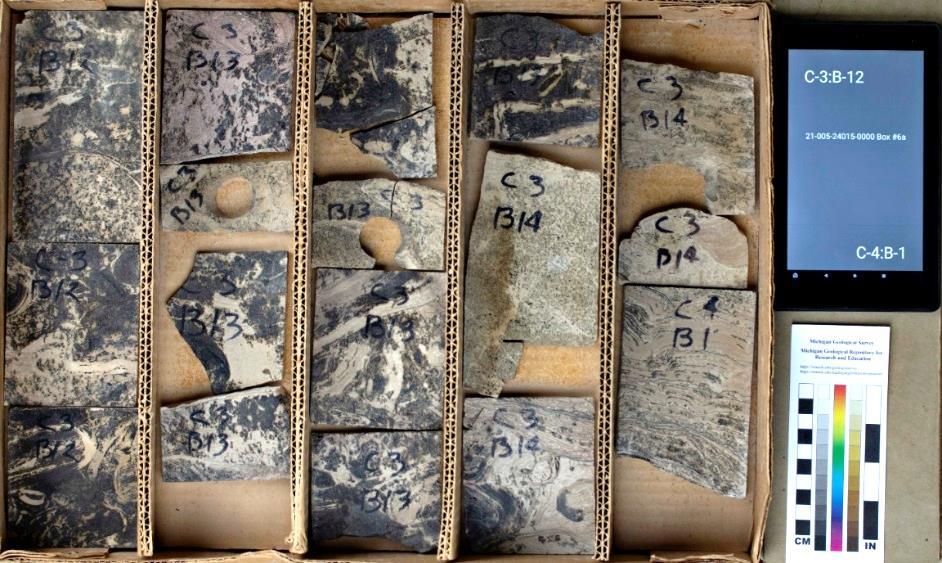
Dissolution of the soluble evaporitic strata in the Salina A1, A-2, B, D and F salt Units resulted in the brittle breakage and collapse of the non-salt unitsin the Salina interval. This residuum of rockthat lookslike concrete is foundpreserved in portions of the Willet No. 1 core from 1605 to 1638 feet. It is a multi-lithology, coarse conglomeritic breccia with clasts from several non-evaporitic Salina units, including the G-Shale, E-Unit C-Shale, and B-Unit. The clasts are a mixture of shale, mudstone and dolostone (Fig. 4&5). The geological interpretation of this core allows us to understand why a presumed oil and gas target in a Silurian pinnacle reef did not produce the anticipated oil and gas. It also helps explain the unusual lithological occurrence of breccia in the Salina Group interval that would have been expected to show thick evaporite deposits. This core provides additional geological understanding about the absence of evaporite strata in southwest Michigan.
 Fig 2. Pinnacle reef facies with tarry residual oil staining from approximately 1,750-1,755’ deep.
Fig. 1. Map location of the Willet No.1 well in Allegan County
Core Stories
Worth Exploration Company-Charles Willet et al. No. 1

Lee Twp.,Allegan County, Sec. 6-T1N-R15W
API#-21005240150000

Cored 1605 to 1805 ft.
Written and Interpreted by: Dr William B. Harrison, III
Citation: Harrison, W.B., III, and Voice, P.J., 2017, Evaporite facies of the Michigan Basin, in Grammer, G.M., Harrison, W.B., III, and Barnes, D.A., eds., Paleozoic Stratigraphy and Resources of the Michigan Basin: Geological Society of America Special Paper 531, p. 197–216, doi:10.1130/2017.2531(10).


Find us across multiple platforms! coming soon >>> New Core/Data
MGRRE received a new slabbed core, core butts, and plugs with wireline logs and analyses from a waste disposal well in Ottawa County. The Prairie du Chein was cored and the Mt. Simon sandstone was sidewall cored
 Fig. 4 Slabbed core from salt dissolution collapse breccia from 1,605-1,610’ deep.
Fig.3. Thickness map of the Salina B Salt.
Fig.5 Slabbed core showing collapse features and oil staining from 1,640-1,647’ deep.
268 387 8691
William.Harrison_III@wmich.edu
Nathan Erber
MGS Senior Research Associate
268 387-8604


Nathan.R.Erber@wmich.edu
Evangelia Murgia MGS Hydrogeologist

268-387-8606
Evangelia.M.Murgia@wmich.edu
Jennifer Trout MGS Research Associate
MGRRE Collections Manager
268-387-8633
Jennfier.l.trout@wmich.edu
Linda Harrison Administrator


268-387-8642
Linda.Harrison@wmich.edu
Peter Voice Research Associate Teaching Faculty Specialist


268-387-5486
Peter.Voice@wmich.edu
Marie Solum Outreach Coordinator
269-387-8608
Marie.Solum@wmich.edu
Directory


 A.Wygant State Geologist and EGLE OGMD Director


 Al Kehew and his map of Barry County
Al Kehew and students in the field
Al Kehew and colleagues collecting borehole samples
Al Kehew, Fred Upton, and John Yellich


 Fig 2. Pinnacle reef facies with tarry residual oil staining from approximately 1,750-1,755’ deep.
Fig. 1. Map location of the Willet No.1 well in Allegan County


