9 minute read
Figure 14: Program Logic Model

from Draft Manning River Catchment and Estuary and Catchment Management Program 2021-2031 - Main document

Figure 14: Program Logic Model
GOAL
ULITIMATE OUTCOMES 50years
“The Manning River, its tributaries and the estuary give life to our community connecting the mountains to the sea. Together w manage the catchment holistically and respond to a changing climate - safeguarding environmental, social, cultural and economic values.”
Manning catchment, river, estuary and marine receiving waters are healthy and resilient. The connection between river ecosystem health, a sustainable economy and a healthy community is widely understood, valued and supported Cohesive NRM management, continuous improvement and partnerships are “business as usual” in the Manning catchment.
INTERMEDIATE OUTCOMES 10years (2030)
Improved land management practices reduce pressures on ecosystem health and resilience The community adopts sustainable behaviours and best practice for land and water management CMP is implemented with strong partnerships between responsible agencies.
SHORT-TERM OUTCOMES 5years (2025)
ACTIVITIES
ACTIVITIES
Evidence-based science informs ongoing management of the catchment and estuary. Improved community understanding and commitment to catchment values, function and stewardship. Stewardship program in place. M&E provides feedback and learning
WQ and Ecosystem Health actions Biodiversity actions Land-use Planning actions
WQ & Ecosystem Health MER Science program Stewardship actions Aboriginal Custodianship actions Economic and Social Values actions
Stakeholder engagement Confirm strategic direction
FOUNDATION ACTIVITIES Literature review, gap analysis, Threat and risk assessment Issue analysis
Manning River ECMP Exhibition Draft V2 June 2021 Stakeholder analysis Engagement Strategy Governance actions
ECMP Monitoring, Evaluation and Reporting (MER)
Establish project team and governance
Page 39
4.1 The estuary and catchment
The Manning estuary is a mature wave dominated barrier estuary covering an area of approximately 32.3km (Roy et al 2001). From the tidal extent at Abbotts Falls up-river of Wingham, the estuary is a single channel to Taree then spills over an extensive floodplain with a complex of inter-connecting channels approximately 115 km in length. Six islands lie between the north and south entrances.
The estuary’s average flushing time is 31.6 days, compared to a State-wide median of 9days (Roper et al. 2011). The long residence time of fresh water makes the estuary particularly sensitive to the accumulation of catchment inputs (Roper et al. 2011). The Manning River estuary has been rated as having medium sensitivity to freshwater inflows (NSW Govt. 2016 p. 10).
There is a moderately significant tidal pool in the main channel of the river directly downstream of Wingham. Despite being affected by daily tidal movements, the tidal pool is primarily fresh and sustains some commercial water extraction4 .
Estuaries are highly productive water bodies where freshwater rand saltwater meet. Estuaries are the “nurseries of the sea.” Their sheltered waters provide vital nesting, breeding and feeding habitats for many species of fish, shellfish, aquatic plants and birds. Most commercially valuable fish species depend on estuaries at some point during their development.5
The Manning River originates at 1570m above sea level in the Gondwana World Heritage Area of the Barrington Tops and flows 261 km to the Tasman Sea on the mid-north coast of NSW. 6 Its catchment covers an area of approximately 8,420km2 with 16 major tributaries, of which 11 are freshwater and five are estuarine (Map 1).
The Manning River is one of Australia’s few large river systems not to be dammed for water supply purposes anywhere along its 261km length and there are no significant on-stream storages on the river.7
The Manning has a mean annual discharge of 1,854 GL/yr. During the Rapid Site Assessment of the Manning catchment at the height of the 2019 drought the major flow centres were posited to be the Barrington Tops, Gloucester Tops and the New England Tablelands as well as regional and local groundwater.8
The Water Services department of MidCoast Council has extensively monitored catchment hydrology, identifying:
4 (Betterridge & Rabbidge, 2016) 5 (NSW Government, Why estuaries are important, 2020) 6 (Betterridge & Rabbidge, 2016) 7 (Betterridge & Rabbidge, 2016) 8 (Swanson, 2020)
• The Barrington-Gloucester Catchment supplies between 25 - 58% of the flow
• The Nowendoc Catchment supplies between 12 -33% of the flow
• The Barnard Catchment supplies 8 - 32% of the flow
• The Little Manning supplies less than 7% of the flow
• Dingo Creek contributes 1 to 10% of the flow.
In the Manning River, the source of water at high flows is variable and depends on the location of rainfall. During low flows the Barrington River is the major source of water to the Manning9 .
The entire Manning River and its tributaries have been designated as Key Fish Habitat by the Department of Primary Industries – Fisheries (DPI-Fisheries), recognising its importance to the sustainability of recreational and commercial fishing industries, the maintenance of fish populations generally and the survival and recovery of threatened aquatic species. 10
9 (Midcoast Water, 2011) 10 NSW Department of Primary Industries (2020)
4.2 Natural assets
Coastal wetlands are known as the kidneys of the landscape, filtering and attenuating pollutants to keep the estuary water clean. They are like sponges, soaking up floodwater and releasing it slowly, mitigating the impact of floods on the estuary. Mangroves stabilise shorelines. Coastal wetlands store carbon, helping to mitigate increases of greenhouse gases in the atmosphere. Coastal wetland are biodiversity hotspots, providing habitat for migratory shorebirds and nursery habitat for many fish, crustaceans and molluscs, including species of commercial and recreational value. Wetlands also provide opportunities for nature-based tourism and have Aboriginal cultural significance, historical significance and importance for science and education.
While coastal wetlands in the Manning have been drained and modified, wetlands of considerable conservation significance still occur11. These include:
• Large areas of mangrove forest and brackish wetlands in areas such as Cattai
Wetlands, Big Swamp and Coopernook Swamp;
• Large wetlands at Dawson wetlands, Kundle Kundle and Manning Point;
• Crowdy Lagoon in Crowdy Bay National Park which is classified as a high priority
Groundwater Dependent Ecosystem (GDE)12; and is listed as a nationally important wetland.
• Forested wetlands with swamp mahogany, broadleaved paperbark and swamp oak13;
• Estuarine and near-shore marine systems made up of coastal mangroves, salt marshes and sea-grass beds which rely on the submarine discharge of groundwater14;
• Seagrass meadows.
A study conducted in Stage 2 of the ECMP mapped 13 types of coastal wetlands in the Manning including broad-leafed paperbark swamps, freshwater wetlands, reedlands, saltmarsh and grey mangrove forest (Annexure F: The Manning River ECMP Coastal Wetlands Mapping Report, Ecological 2019). The study found that:
• 69% of coastal wetlands were in good/excellent condition
• 19% in fair condition
• 12% in poor/very poor condition
The majority (86%) of all wetland types mapped are identified and protected under State or Commonwealth legislation
11 (Eco Logical Australia Pty Ltd, 2019) 12 (NSW Government - Office of Water, 2009) 13 (MidCoast Council, 2020) 14 (Geosciences Australia, undated)
Freshwater wetlands contribute to base flow of the river15. Some of these wetlands such as the alpine swamps in the Barrington Tops are high priority Groundwater Dependent Ecosystems16 .
Photo: Coastal wetlands are the kidneys of the landscape
15 (Midcoast Water, 2011) 16 (NSW Government - Office of Water, 2009)
Groundwater aquifers are found throughout the Manning catchment. 17 They make a significant contribution to baseflow in the river (Pers. Comm. Dr. Peter Serov, August 2019). Groundwater “commonly provides an important and reliable source of water to many ecosystems and can be the main factor controlling the distribution of ecosystem types” (Geoscience Australia). Up-river alluvial aquifers and coastal sand aquifers have significant connectivity to surface water.18 Understanding the connection between groundwater and surface water is important when regulating groundwater use, recognising that draw-down of the aquifer influences surface water flows.
Groundwater Dependent Ecosystems are ecosystems that depend on groundwater for some or all their water requirements. Coastal wetlands and estuarine and near-shore marine systems such as coastal mangroves, salt marshes and sea-grass beds in the Manning River Estuary are classified as Groundwater Dependent Ecosystems, as they rely on the submarine discharge of groundwater (Geoscience Australia).
Healthy in-stream condition contributes to conservation of aquatic fauna such as the Platypus and Manning River Helmeted Turtle, and the productivity of fisheries including commercial species. Water sources with high instream value in the Manning Catchment include sections of the Upper, Mid and Lower Manning; Upper and Lower Gloucester and Barrington; Upper Barnard, Bowman and Nowendoc Rivers (NSW Govt. 2016 p. 12-14).
Riparian vegetation plays a central role in stabilising waterways, reducing channel boundary erosion, filtering diffuse-source run-off and providing habitat. Riparian vegetation helps maintain water quality by reducing the amount of pollutants entering the waterway. It serves as a physical buffer, slowing down overland flow and mitigating the negative impacts of flooding. 19 All of these ecosystem services benefit the estuary.
Vegetated riparian areas are also very important for biological connectivity. Intact and connected riparian vegetation provides dispersion corridors for wildlife and sequesters carbon, mitigating the impact of climate change.
Noel Piercy, Member, ECMP Reference group
Terrestrial vegetation including ground cover has an important role to play in soil organics, erosion control, providing shade for livestock away from watercourses, driving the local water cycle and hydrating the landscape. It will be managed through Council’s Biodiversity Framework.
Rivers, riparian zones and estuaries are exceptionally biodiverse because they form transition zones between aquatic and terrestrial ecosystems. MidCoast Council’s draft Biodiversity Framework provides a full listing of biodiversity assets and management strategies in the Manning region. The focus for the ECMP is on aquatic and riparian fauna, and particularly listed threatened species, within the planning area. These include:
• The endangered (NSW) Manning River helmeted turtle whose entire known range is confined to the Manning catchment.
17 (Commonwealth of Australia, 2017-18) 18 (Betterridge & Rabbidge, 2016) 19 (Swanson, 2020)
• The iconic platypus reported to be nearing threatened-species status.20
• A maternity camp of vulnerable grey-headed flying fox in a patch of Sub-tropical
Lowland Rainforest (EEC) at Wingham Brush. Flying foxes are keystone pollinators of over 50 native tree species and are critical to the survival of riparian vegetation.
• At least twenty-five species of fish in the freshwater reaches21. Migratory fish play a critical role in keeping our rivers, wetlands and oceans healthy by supporting a complex food web. Populations are declining globally22 .
Managing riparian vegetation is a primary tool for catchment-scale improvements23 .
Freshwater refuge pools play a critical role in supporting local and regional biodiversity. Deep freshwater pools and springs are home to an array of fauna forming biodiversity hotspots. Aquatic wildlife species retreat to, persist in and expand from refuge pools under changing environmental conditions24 .
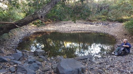
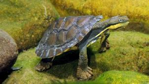
Photo courtesy of Gary Stephenson.
20 (University of New South Wales, 2020) 21 (Bishop, 2016) 22 (World Fish Migration Foundation, 2020) 23 (Pietsch, Daley, Stout, & Brooks, 2019) 24 (Keppel et al, 2011)


