November 2021


November 2021
Plan of Management Report prepared by Lands Advisory Services Pty Ltd
265 King Street Newcastle NSW 2300
Email: enquiries@landsas.com.au

November2017
© Lands Advisory Services Pty Ltd 2017
Disclaimer:
Drawings, figures, analysis, forecasts and other details in this report have been prepared in good faith based on data and information supplied to Lands Advisory Services Pty Ltd by others. The data is believed to be correct at the time of publication of this Report. However, it is noted that predictions, forecasts and calculations are subject to assumptions which may or may not turn out to be accurate. Lands Advisory Services Pty Ltd expressly disclaims all and any liability to any person or persons in reliance on the Report and its contents in part or in whole.
The Nabiac Showground is a substantial complex of crucial significance to the town of Nabiac and the region. It creates a common focus for community commitment and relationships, hosting a diverse range of events, interests and activities, all integral to the health and lifestyle of a small rural centre. The annual agricultural show, rodeo and other horse sports, farmers markets, the public library and hall, soccer, football, cattle markets and recreational camping all take place on the site.
Nabiac Showground is on a Crown reserve owned by the State Government and managed by MidCoast Council for the benefit of the community.
The intention of this Plan of Management is to provide Council with a framework that enables decisions in regard to the site, to be made on an informed, consistent and equitable basis. The Plan meets all of the requirements of the Local Government Act 1993
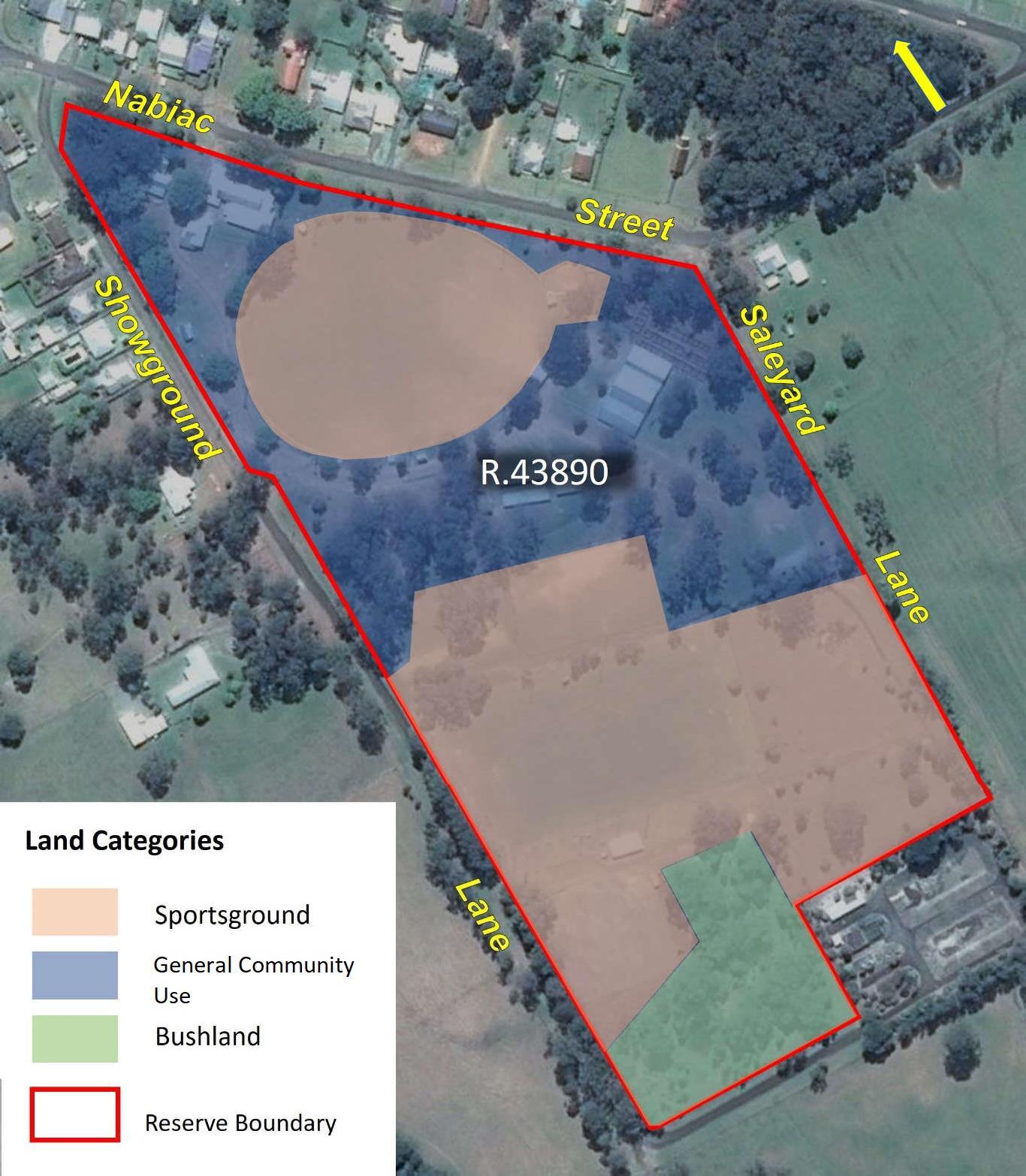
The land at Nabiac Showground is categorised as:
• Sportsground
• General Community Use
• Natural Area – Bushland
A description of each category of land as it exists at the Reserve is provided. The current use patterns, built and natural assets and their condition, emerging trends, constraints and influences, have been considered in this Plan of Management. Appropriate management objectives and actions, as well as an effective management structure and communication strategy for successful implementation are key outcomes provided by the Plan.
This Plan is presented in two principal sections being the site description (A), which describes the constraints of the site, and the fundamental components of the Plan (B), which describes what is planned for the site’s future.
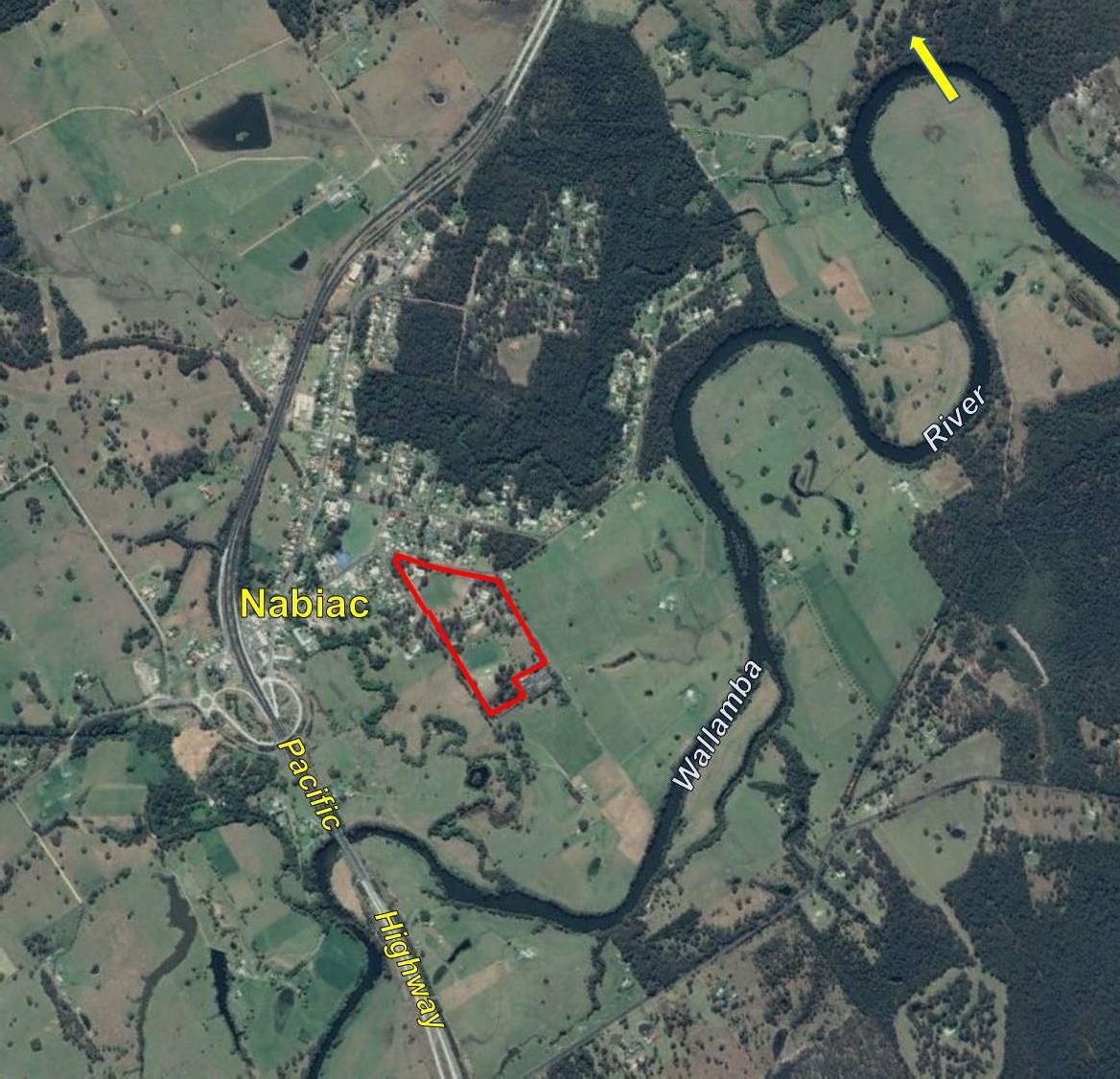
The village of Nabiac is located on the Mid North Coast of NSW, 24 km south of Taree and 25 km west of Forster/Tuncurry. Nabiac has a population of about 650 and provides services for the surrounding hamlets of Wootton, Failford, Rainbow Flat, Dyers Crossing, Krambach and Coolongolook.
Nabiac holds a prime position in the recently created MidCoast Council being on the Pacific Highway at close to the mid-point between the northern and southern extremities of the local government area and also being the most central town between the administrative centres of Forster, Taree and Gloucester.
With a recent influx of retirees and families migrating north from Sydney for a healthier lifestyle, the formative rural based industry emphasising dairying and timber production, has transitioned towards an increase in small hobby farms and raising of beef cattle. The new section of the Pacific Highway completed in 2006 also altered trends in the use of this main road, creating a more prominent “gateway” role for both visitations and settlement from the south, to the Great Lakes, Manning and the North Coast movement of people.1
Nabiac was originally proposed to be part of the Port Stephens to Manning River Australian Agricultural Company Grant of 1828. This section was relinquished in 1836 in favour of the Peel River and Warra Estates and the area became available for closer settlement after 1850. Settlement for the Nabiac village commenced with the first lot purchases in 1855.2
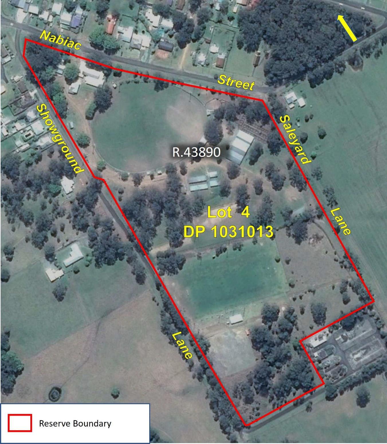
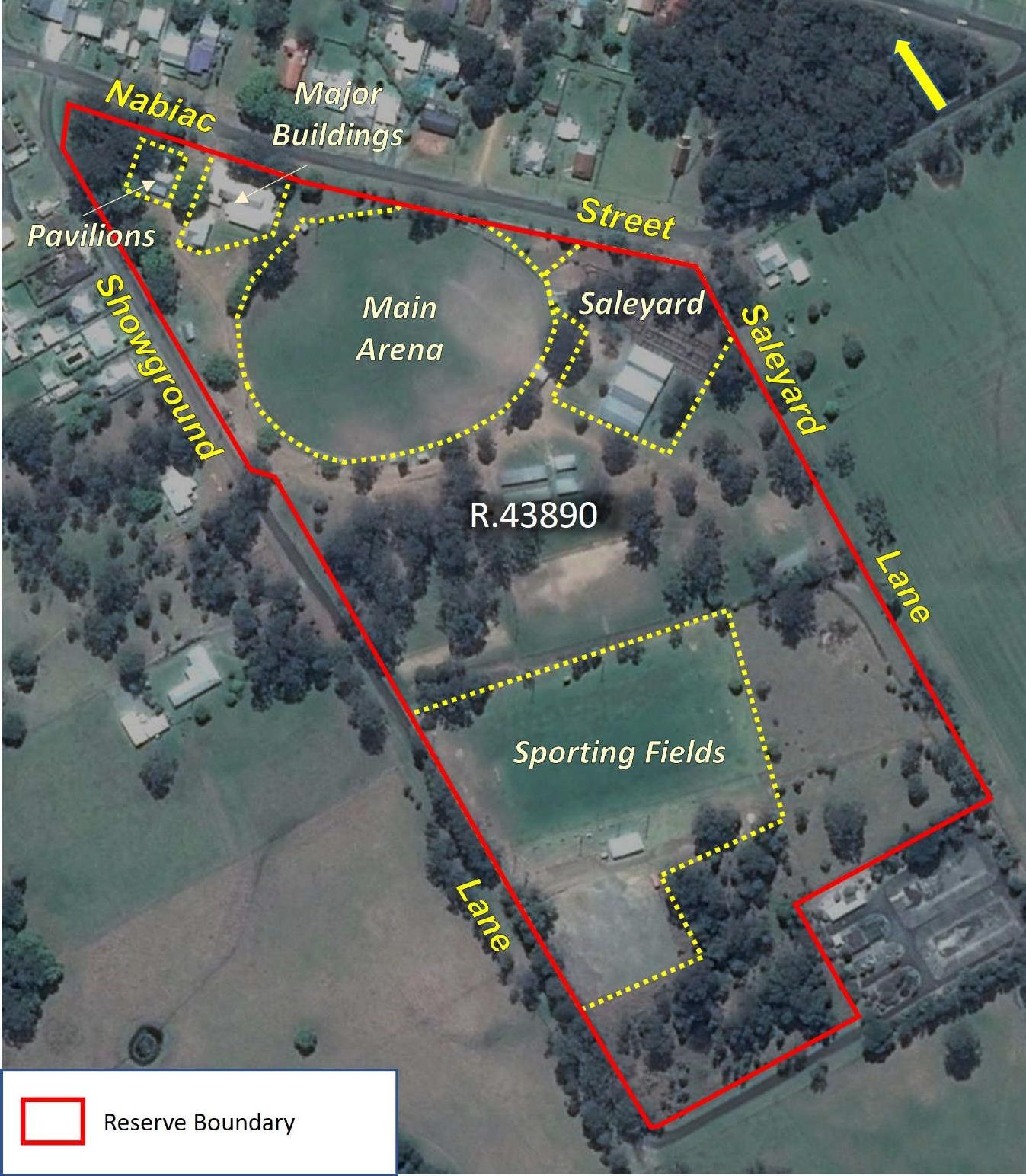
The Reserve, which is located on the south-eastern side of the village (see Figure 1 locality map), bounded by Nabiac Street, Showground Land and Saleyard Lane was gazetted for Public Recreation and Showground on 12 May 1909, replacing earlier reservations for Recreation (20 November 1886) and Showground and Athletics Sports (17 July 1903).
The first show of the Wallamba District Agricultural and Horticultural Association was held in April 1912. This Reserve now consists of a complex catering for the multi-functional interests and activities of the people of Nabiac and further afield, including the annual agricultural show, a range of horse sports, camping, rugby union and soccer.
This Plan of Management (PoM) has been prepared in order to achieve a balanced, responsible and ecologically sustainable use of the land and to ensure that it addresses the needs of the local neighbourhood, the broader community, and the environment. It has been prepared to meet the requirements of the Local Government Act 1993.
This land, briefly described above, is Crown land managed by MidCoast Council.
Crown land is owned by the State of New South Wales for the benefit of all persons. Local Government Authorities manage Crown land on behalf of the State, as Crown Land Managers, under Division 3.4 of the Crown Land Management Act 2016 (CLMA). The CLMA provides that Council should manage the land under the Local Government Act 1993 (LGA).
Under the LGA, all public lands must be classified as either Community, or Operational land. The land shown in Figure 2 has been classified ‘Community’ land under the provisions of the LGA
The purpose of the classification is to clearly delineate which land should be kept for use by the general public (Community) and which land need not be kept for that purpose (Operational). The major consequence of the classification is that it determines the ease or difficulty by which the land may be alienated by sale, lease or other means. Community land would ordinarily comprise land such as a
sportsground, hall, public park etc.,3 and Operational land would consist of land which facilitates carrying out of a public service, such works depots, or land held as a temporary asset or investment.

Community land:
• cannot be sold
• cannot be leased, licenced or any other estate granted over the land for more than 30 years4
• must have a PoM prepared for it.
3 See the note to Chapter 6, Part 2 of the LGA.
4 Leases of greater than 21 years require Minister’s consent
The LGA requires that Plans of Management are to be created over Community Land. A PoM is created, in conjunction with the community, to identify the important features of the land, clarify how Council will manage the land and how the land may be used or developed. Until a PoM for Community Land is adopted, the nature and use of the land cannot be changed. To change this, the PoM must be revised.
Plans of Management over Crown land can be created:
• under Division 3.6 of the CLMA by a non-council manager;5 or
• under Chapter 6 Part 2 of the LGA by a council manager.6
The PoM provides direction and continuity for the planning, management and maintenance of public open space under the management of local government.
Council will undertake the required process as per Section 36 of the LGA for this PoM.
As required by legislation for the purposes of the PoM, community land is categorised as one of the following:
• Park
• Sports Ground
• General Community Use
• Area of Cultural Significance
• Natural Area
Bushland
Wetland o Watercourse
Escarpment o Foreshore
The initial categorisation for Nabiac Showground under Section 3.23 of the CLMA was General Community Use.

The LGA allows a PoM to cover one or multiple parcels of land.
Where multiple parcels of land are covered in one plan (Generic Plans), the LGA specifically states what needs to be included. Where a PoM covers one parcel of land (Specific Plans), like this Plan, there is greater detail on what has to be prescribed in the Plan. A Generic Plan sets the framework of how the land is to be managed. A Specific Plan clearly outlines very precise management proposals.
PoMs for community land are periodically reviewed to enable changing social, economic and ecological conditions to be taken into account and consequently amendments to the Plan may occur. This PoM for the Nabiac Showground (the Reserve) will be its first.
Council currently has a suite of Generic and Specific Plans of Management. A register of these plans is kept in the Parks and Recreation Section and are updated accordingly.
Table 1 - Site Description
Reserve Reserve R.43890 for Public Recreation and Showground – established 12 May 1909
Description Lot 4 DP 1031013
Address 41 Nabiac Street, Nabiac 2312
Initial Category General Community Use
Proposed Categories Sportsground, General Community Use and Natural Area – Bushland
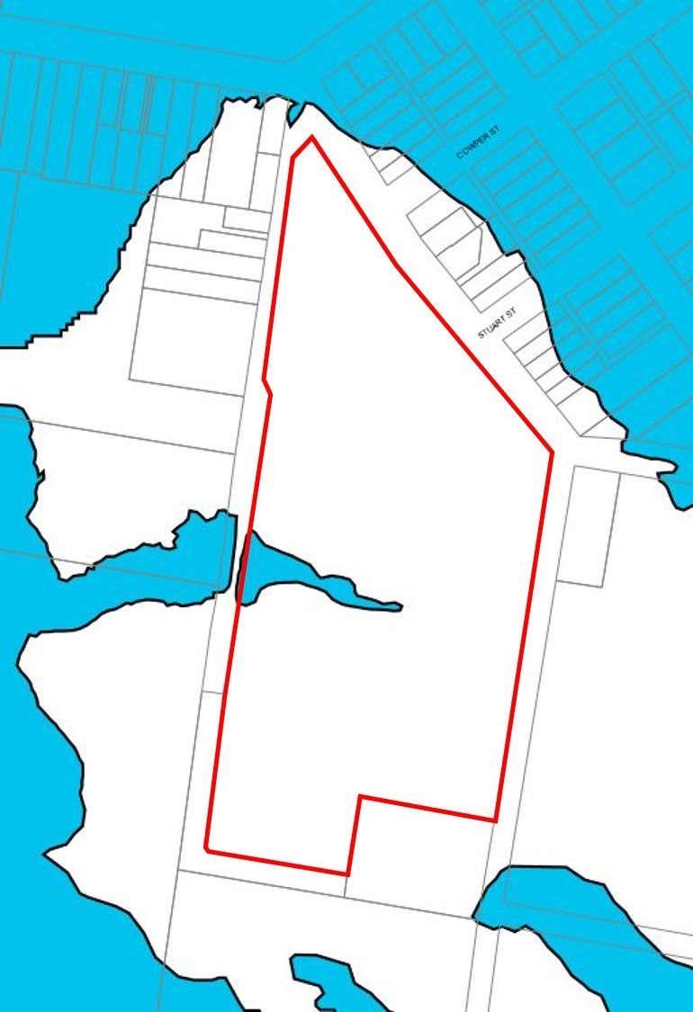
The Reserve for which this PoM is compiled, lies within the MidCoast Local Government Area on the south-eastern side of the village of Nabiac in New South Wales, Parish of Talawahl, County of Gloucester.
The property address of the Reserve is 41 Nabiac Street, Nabiac 2312, and covers Lot 4 in Deposited Plan 1031013 (see Figure 2):
The northern-eastern boundary and main frontage of the Reserve is Nabiac Street, the western boundary is Showground Lane and the eastern boundary is Saleyard Lane.
The total area of the Reserve is 11.82 hectares.
There is no adjoining land classified as Operational, as per the LGA.
Nabiac Showground is on Crown land owned by the State of New South Wales. The land is subject to a Reserve (R.43890) for Public Recreation and Showground, under the CLMA, established on 12 May 1909. All assets on the Reserve are owned by the State of New South Wales.
Council is the appointed Crown land manager under the CLMA. Council, as the Council of the Shire of Great Lakes was appointed trustee of the Reserve on 17 March 2000.
Crown land in Australia is subject to Native title under the Native Title Act 1993 (Commonwealth) unless Native title has been validly extinguished. On Crown land Native title rights and interests must be considered unless:
• Native title has been extinguished; or
• Native title has been surrendered; or
• Determined by a court to no longer exist.
Some examples of acts which may affect native title on Crown land or Crown reserves managed by
Council include:
• the construction of new buildings and other facilities such as toilet blocks, walking tracks, tennis courts, grandstands and barbecues,
• the construction of extensions to existing buildings,
• the construction of new roads or tracks,
• installation of infrastructure such as powerlines, sewerage pipes, etc.,
• the issue of a lease or licence,
• the undertaking of major earthworks.
When proposing any act that may affect native title on Crown land or Crown reserves the act must be authorised through Part 2 Division 3 of the Native Title Act 1993 (Cwlth).
The Aboriginal Land Rights Act 1983 (ALRA) seeks to compensate Aboriginal peoples for past dispossession, dislocation and loss of land in NSW. The lodgment of an aboriginal land claim (ALC) under section 36 of the ALRA, over Crown land creates an inchoate interest in the land for the claimant pending determination of the claim. The Department of Planning and Environment – Crown lands (DPE-CL) advises that, if the land is subject to an undetermined ALC, any works, development or tenures authorised by the PoM should not go ahead if:
• the proposed activity could prevent the land being transferred to an ALC claimant in the event that an undetermined claim is granted
• the proposed activity could impact or change the physical/environmental condition of the land, unless:
o the council manager has obtained written consent from the claimant Aboriginal Land Council to carry out the proposed work or activity, and/or
o the council manager has obtained a written statement from the Aboriginal Land Council confirming that the subject land is withdrawn (in whole or partial) from the land claim
• the proposed activity is a lease to be registered on title unless the council manager has obtained written consent from the claimant Aboriginal Land Council
At the time of drafting DPE-CL advised there were no undetermined ALCs over Nabiac Showground.
Section 3.21 of the CLMA authorises Council to manage the land as if it were public land within the meaning of the LGA. Under the LGA, all public lands must be classified as either Community or Operational land and this land has been classified ‘Community’ land.
The Nabiac Showground Management Committee (NSMC) is an Asset Committee established by Council under Section 355 of the LGA. Following amalgamation of Great Lakes Shire, Greater Taree City and Gloucester Shire Councils into MidCoast Council on 12 May 2016, Council's representation
on all Section 355 committees, via a Councillor was suspended until such time as a newly elected body was formed in September 2017.7
7 Council is currently in the process of determining which Committees will have Councillor representation and if so, which Councillor will be a member of the NSMC.
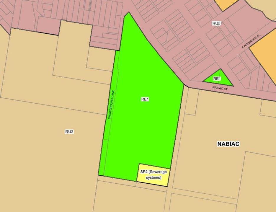
Under the Great Lakes Local Environmental Plan 2014 (LEP),8 the Reserve in total is zoned RE1 – Public Recreation (See Figure 3).
The objectives of the RE1 – Public Recreation zone are:
• To enable land to be used for public open space or recreational purposes.
• To provide a range of recreational settings and activities and compatible land uses.
• To protect and enhance the natural environment for recreational purposes.
• To provide for a range of educational, environmental, community and cultural uses for the benefit of the community.
• To enable access to activities and businesses located within adjacent waterways.
There are no activities permitted without consent.
The following activities are permitted with consent:
• Boat launching ramps
• Camping grounds
• Car parks
• Caravan parks
• Community facilities
• Depots
• Eco-tourist facilities
• Emergency services facilities
• Environmental facilities
• Environmental protection works
• Flood mitigation works
• Function centres
• Heliports
• Information and education facilities
• Jetties
• Kiosks
• Marinas
• Markets
• Plant nurseries
• Recreation areas
• Recreation facilities (indoor)
• Recreation facilities (major)
• Recreation facilities (outdoor)
• Registered clubs
• Research stations
• Restaurants or cafes
• Roads
• Sewerage systems
• Signage
• Waste or resource management facilities
• Water recreation structures
• Water supply systems
• Wharf or boating facilities
Subject to State and Regional Environmental Planning Policies that apply to this land all other development is prohibited.
8 The recent amalgamations for three former contiguous local government areas will mean that respective policy documents including LEPs, will merge formally into those of the new MidCoast Local Government Area. At the time
of compiling this PoM, the titles of respective LEPs remain.
the more elevated land to its north.
The LEP requires that development consent must not be granted to development on flood affected land unless the consent authority is satisfied that the development:
(a) is compatible with the flood hazard of the land, and
(b) will not significantly adversely affect flood behaviour resulting in detrimental increases in the potential flood affectation of other development or properties, and
(c) incorporates appropriate measures to manage risk to life from flood, and
(d) will not significantly adversely affect the environment or cause avoidable erosion, siltation,
destruction of riparian vegetation or a reduction in the stability of river banks or watercourses, and
(e) is not likely to result in unsustainable social and economic costs to the community as a consequence of flooding.
The land is subject to the Great Lakes Development Control Plan 2014 (DCP) section 4.2 – Flooding. The DCP contains subdivision and building controls relating to flooding and also has conditions relating to fencing.
Nabiac Showground is subject to the State Environmental Planning Policies below. Those that are considered more relevant to the future of the Showground and this PoM are underlined below and briefly described in Appendix4
• State Environmental Planning Policy (Affordable Rental Housing) 2009
• State Environmental Planning Policy (Building Sustainability Index: BASIX) 2004
• State Environmental Planning Policy (Coastal Management) 2018
• State Environmental Planning Policy (Concurrences and Consents) 2018
• State Environmental Planning Policy (Educational Establishments and Child Care Facilities) 2017
• State Environmental Planning Policy (Exempt and Complying Development Codes) 2008
• State Environmental Planning Policy (Housing for Seniors or People with a Disability) 2004
• State Environmental Planning Policy (Infrastructure) 2007
• State Environmental Planning Policy (Mining, Petroleum Production and Extractive Industries) 2007
• State Environmental Planning Policy (Primary Production and Rural Development) 2019
• State Environmental Planning
•
•
•
Areas) 2017
Council has developed a number of plans and general policies which have either direct or indirect relevance to planning, management and maintenance of Community Land and Council Reserves. Of particular note;
• The Great Lakes Plan of Management (guideline), adopted in 2012 provides an overarching framework for the compilation of Plans of Management for community lands, listing all relevant legislation and policy.
• Recreation and Open Space Strategy (ROSS), complied for Council in 2006 contains projections until 2026, providing much insight into proposed management of recreation and open space areas in the (former Great Lakes) local government area, including Nabiac Showground.
• MidCoast Council Community Engagement Policy, adopted in 2017 outlines the principles and activities that guide community engagement practices to ensure effective community contribution to the Council Decision making process.
• MidCoast Council Leasing/Licencing of Council Land & Buildings Policy, adopted in 2017 provides for a consistent, transparent and fair approach to the leasing or licensing of Council Property and to maximise the community benefit by encouraging the multiple use of community facilities.
• MidCoast Council Terms & Conditions for use of Recreational Spaces Procedure, approved in 2016 provides for the operational aspects of organised usage of Council's sporting and recreational facilities.
All relevant policies can be found at Council’s website at www.midcoast.nsw.gov.au.9
This PoM is consistent with these plans, strategies and policies.
The Reserve has no operating approvals issued under the LGA
9 The majority of relevant policies appear in the references of this Plan.
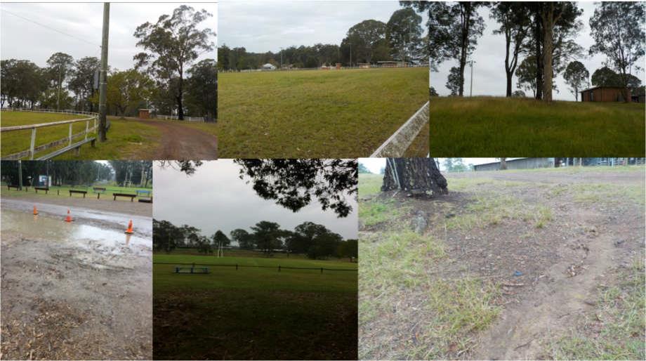
The Reserve lies within the Wallamba River catchment which drains eastward into Wallis Lake, exiting into the ocean near Forster. The Reserve is located on variable topographies from an elevated well drained ridge and crest in the northern section on which the majority of infrastructure exists. This landform falls relatively steeply to the south towards a poorly drained footslope which continues to the southern boundary. Local drainage from the Reserve eventually accesses the Wallamba River from various directions on the Reserve: via a flood prone western flowing drainage line which separates the two main landform units; to the east from the footslope and flat land at the southern end of the Reserve and to the north west from those more elevated terrains with northerly aspect.
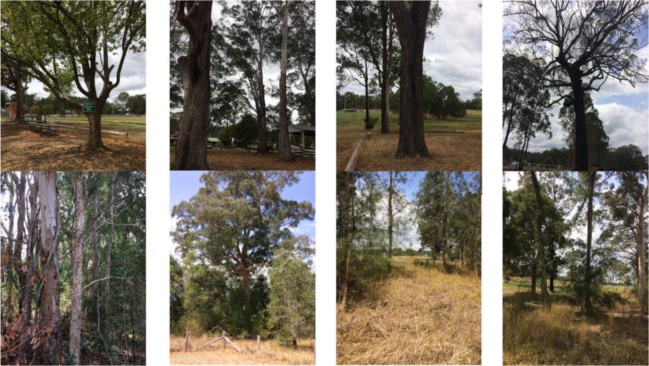
Figure
visually depicts landform, aspect and drainage from the land.
Clock-wise top left: crest of elevated land unit with vehicle track (south of main arena) is well drained; main arena slopes slightly to the north; well grassed slope with southern aspect, south of main arena; depicting erosive nature of soils where exposed on slopes; footslope to the south is poorly drained; carpark, at sporting field.
Because of its distance from the coastline, the Reserve is not impacted by the Coastal Management Act 2016. However, the above-mentioned western flowing drainage line is located on a footslope adjoining a floodplain, and is therefore subject to Clause 7.3 (Flood Planning) of the LEP.
Clause 7.3 objectives are to:
• minimise the flood risk to life and property associated with the use of the land,
• allow development on land that is compatible with the land’s flood hazard, taking into account projected changes as a result of climate change, and
• avoid significant adverse impacts on flood behavior or the environment.
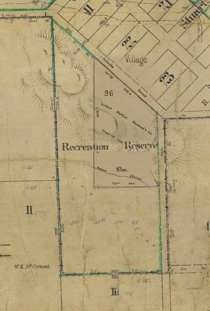
During initial site development, post the original 1886 gazettal, the natural environment of the Reserve experienced modifications, commencing with the initial partial clearing of the land for its preparation. In following decades after the final and current gazettal of 1909, the land surface has been modified to allow establishment of the showground arena and hall (commencing 1911), and for the installation of all other infrastructure and facilities.
It is likely that the original vegetation would have been a dominant grassland interspersed with single or clumps of Eucalyptus (open) woodland trees and shrubs on the elevated topography, thickening into the small riparian area along the drainage line and the footslope to the south, carrying Melaleuca and Casuarina species in addition to a range of Eucalypts and understory shrubs.
A section of the survey map of 1902 (see Figure 6) for a section of the current Reserve, depicts the surveyor’s description of the original woody vegetation on the elevated ridge area to the south of the main arena (“Gum, Ironbark, Blackbutt, Bloodwood and Oak”). As described in that early survey, examples of the Ironbark, at least two additional Eucalypt (Gum) species, and an occasional Bloodwood (Corymbia species) tree, still remain on the ridge and its southern slope today.
The soils of the Reserve closely reflect their origins, as:
• soils formed in situ on the metasediments (siltstone/mudstone) of the elevated terrain, and which are acidic, reasonably well drained, with hard setting surfaces, and are of moderate soil erosion hazard. (Also see Figure 6 for original surveyor’s notes included in this area: “Gravel and Loam”.)
• soils deposited alluvially or colluvially on the lower terrains of footslopes and drainage area, and which are acidic, poorly drained and often waterlogged.
Soil profile descriptions recorded in the vicinity of Nabiac and the Reserve for like-landforms within the NSW government’s soils database for the Bulahdelah 1:100,000 mapping sheet (www.environment.nsw.gov.au/eSpade2Webapp//) provide the following profile descriptions which have been generalised and condensed for this PoM:
Elevated terrain:
0-5 cm Brownish-black Silt Loam PH 5.5, few (0-20%) coarse fragments of gravel and ferromanganiferous materials
5-13 cm Sporadically bleached Yellowish Grey-Brown Sandy Clay Loam PH 5.5, few coarse materials
13-60 cm Yellowish Grey-Brown Light Medium Clay to Medium Heavy Clay, PH 5.0, strong/harsh structure. (Parent material mudstones, shales, sandstones normally encountered at or before this depth.)
Footslope/drainage area:
0-10 cm Brownish-black Silt Loam, weakly structured PH 5.0 (field), sharp boundary to
10-35 cm Dull yellowish brown Silty Clay Loam with massive structure PH 5.5 ferro-manganiferous segregations common (10-20%), sharp boundary to 35-100 cm Dull yellow orange Silt Clay, strongly pedal (sodic).
Habitat values on the Reserve are associated with the following native and naturalised vegetation:
• Plantings of a range of well-established tree species in the vicinity of the main buildings commencing in the main entrance area. These include well established Blackbutt (Eucalyptus pilularis), Tallowood (E. microcorys), and the introduced Camphor Laurel (Cynnamomum camphora).
• The remnants of the (formerly described) native Ironbark dominant woodland on the higher topography and it southern side slope, also including groundcover grasses and broadleaved species (native and naturalised) which exist as part of the woodland, or on the open areas of maximum use including the main arena.
• Naturally occurring ground cover species including grasses and a range of broadleaved species in the drainage area. On the playing fields, there is a well-maintained ground cover of turf species suitable for more intensive sporting uses by people.
• A woodland of mixed native trees and shrubs of varying ages to the south of the playing fields in the southern section of the Reserve. These include Ironbark, Casuarina, Forest Red Gum, Melaleuca (paper bark), and native understory shrubs with a good cover of native and nonnative grasses. The introduced and weedy Camphor Laurel, Lantana and Mimosa are also present. A small constructed dam also complements habitat values in this section.
These vegetation distributions are well depicted in the aerial image (see Figure 2), and are also shown in Figure 8.
Note that the land at the Reserve is impacted by Clause 5.9 of the LEP, relating to the Preservation of Trees and Vegetation. This clause prohibits ring barking, cutting down, lopping, removing, injuring or willfully destroying trees and vegetation without Council consent.
Also note that this land is Bush Fire Prone land and is therefore subject to the Nabiac and Failford Fire Mitigation Plan (2007).
Under the LGA, Council has obligations for conservation issues as determined by the Biodiversity Conservation Act 2016 and the Fisheries Management Act 1994. The LEP or the respective 149 certificates contain no notation of any significant biodiversity issues present at the Reserve. There is no biodiversity certified land or biobanking agreement associated with this land as per the Biodiversity Conservation Act 2016. Council’s Tree Preservation Order and Tree Inventory contains no trees of significance, on this site. Biodiversity value of the Reserve generally follows the descriptions provided in 4.4 above.
There are no named creeks on or in the immediate vicinity of the Reserve. Section 3.2 above, describes a small section of the land occupied by the Reserve, as flood prone (see Figure 4). This is the small drainage line located between the footslope in the south, and the elevated terrain in the north which reaches the Wallamba River via an un-named drainage system.
The LEP presents Council’s objectives for the protection and maintenance of riparian lands and watercourses, including the nearby Wallamba River, by maintaining the following:
• Water quality within watercourses
• The stability of the bed and banks of watercourses
• Aquatic and riparian habitat, and
• Ecological processes within watercourses and riparian areas.
The Reserve does not contain any items listed in the LEP as being of known aboriginal archaeological sites, nor places of heritage significance.
A search of the Office of the Environment and Heritage AHIMS Web Services (Aboriginal Heritage Information Management System) did not reveal that:
• aboriginal sites are recorded in or near the Reserve (200 m buffer)
• aboriginal places have been declared in or near the Reserve (200 m buffer).
The LEP lists the Reserve as heritage listed. The relevant 149 Certificate indicates the existence of heritage items and controls with respect to development of heritage buildings. A submission regarding the potential heritage status of structures on the land, including the Hall constructed between 1911 and 1912, and other infrastructure, was completed by the NSW Heritage Office in 2009.10
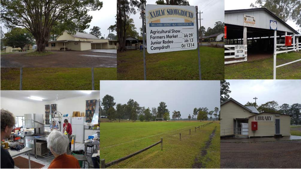
The Community Strategic Plan11 appropriately describes the focal role of the Nabiac Showground and Hall, as the home of the annual Wallamba District Agricultural Show, junior rodeos, camp drafting and the monthly Nabiac Farmers Market, whilst also hosting the local branch of the Great Lakes Library.
Other functions which are conducted on the Reserve include the monthly cattle sales, pony club and camps, team penning, barrel racing, Men’s Shed, dog shows, with rugby and football on the sports field. The local Landcare group also has an interest in the management of the Reserve. Collectively, these functions create an important focus for this community, and the opportunity for further development and utilisation of the Reserve will be an important ongoing consideration.
The Reserve provides ready access to pedestrians and casual users as well as planned sporting events and practice. It is well positioned to address the casual and active needs of the local community, as well as provide a linkage to other open space areas nearby.
The Reserve is currently used as active open space by the following sporting, social and business bodies under agreement with Council, in accordance with MidCoast Council’s Terms and Conditions for Use of Recreational Spaces procedures (March 2016):
Regular Users - Showground
• Wallamba River Pony Club - monthly training club days and 2 competition days
• Team Penning - monthly training days
• Gooch Agencies - monthly cattle sales
• Community Hall Committee
• Farmers Markets - Monthly
Annual Events
• Wallamba Agricultural & Horticultural Show
• Campdraft
• Junior Rodeo
• Caravan & Camping Show (annually held twice in the last 3 years)
Sports field Users
• Wallamba Football (soccer) Club - Winter
11 Community Strategic Plan 2016-2021. Coordinated by Nabiac Village Futures Group 2015.
• Wallamba Rugby Union Football Club – Winter
Local residents and visitors have ready access to the Reserve and opportunities exist for a range of passive activities including:
• Motor home stays both informally and in association with sporting events (eg., eventing, pony club).
• Walking and exercising.
• Town Library (opens 4 days per week). 12
• Community hall. Bookings include weddings, parties, meeting place for various community groups.
Tenures are issued over community lands in accordance with MidCoast Council’s Leasing/Licencing of Council Lands and Buildings Policy (2017), and in accordance with the LGA (see 10.3). The following tenures exist at the Reserve:
• Licence agreement with Gooch Agencies for the operation of monthly cattle sales, commencing 1 February 2022 for 12 months.
• Licence agreement with Nabiac Farmers Market for the operation of monthly markets, commencing 1 July 2021 for 3 years with 2 x 3 year options.
• Licence agreement with Wallamba District Agricultural and Horticultural Association for the use of Nabiac Showground Hall, commencing 1 July 2022 for 5 years.
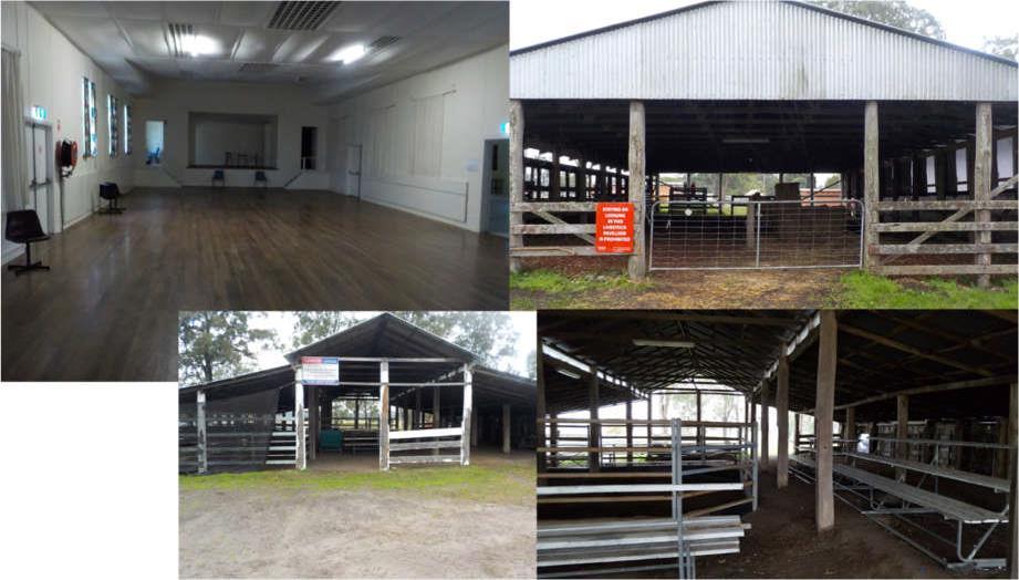
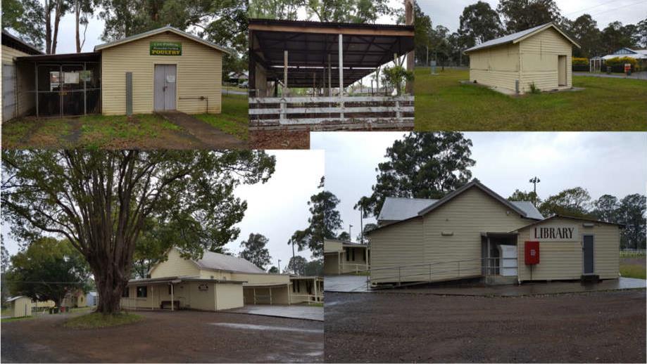
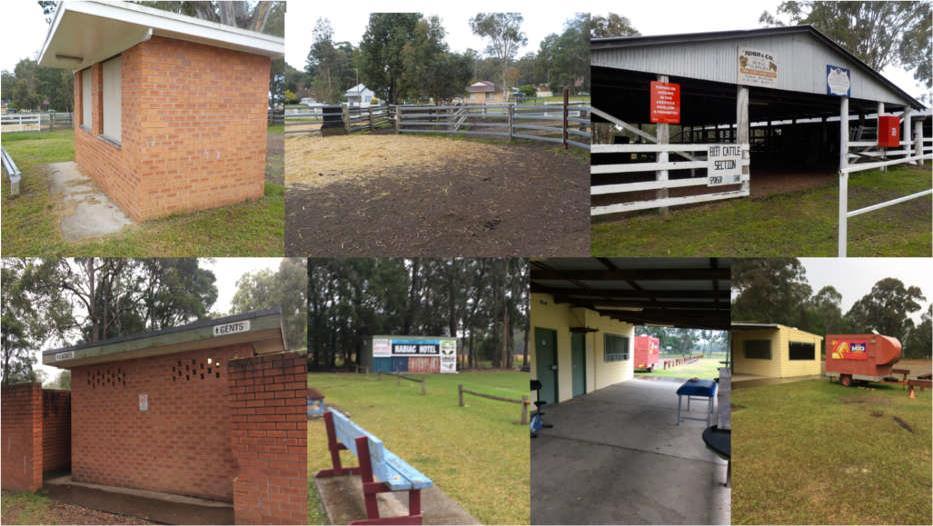
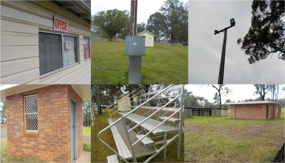
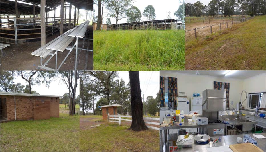
The Reserve’s main assets were inspected and recorded. A preliminary assessment of asset condition is described in Table 2, complementing the MidCoast Council’s previously completed Conditions Report.13 Because of the number of assets involved, the approach was to segment the Reserve’s grounds into spatial activity clusters (see Figure 10).
The historical nature of many of the major assets at the Reserve provides a quaintness and charm, as well as good to reasonable serviceability at this point. However, for the same reason, there exists a major consideration for future asset management at the Reserve. Without a commitment to a significant funding stream, many of these same assets as they continue to age, will quickly fall into a state of disrepair and serviceability. Of particular concern are the following assets:
• The Community Hall
• Community Library
• The various show pavilions
• Cattle stalls
• Horse stalls (2)
• Entrance (Showground Lane) including fence, gate and ticket box
• Kiosk 1 /men’s shed (floor)
• Amenities blocks and Club Room and Kiosk (playing fields).
The following series of Figures (11-14) depict a range of assets across the Reserve.
Prior to formal commencement of this PoM, discussions with all user groups at the Reserve were conducted and views on a range of issues related to physical assets were captured in a standard Strengths-Weaknesses-Opportunities-Threats (see Appendix 3 for more information). A number of issues were acknowledged during this process which will impact on the success and sustainability of the Reserve into the future. Many of these will be addressed in the Action Plan (Section 12). They are:
• General lack of pedestrian pathways: A pedestrian linkage between the village and the Reserve, particularly, adequate strategic internal pathways are required to link major venues for people on-foot, with safety and comfort.
• TheCommunityHallissomewhatuncomfortable: Heating should be adequate to attract great night-time patronage in Winter months. The acoustics are poor and ceiling fans are noisy.
• Tree safety: A number of hazardous trees (mainly Ironbark) require urgent attention due to falling limbs.
• Aginginfrastructure: The aging nature of much of the infrastructure is acknowledged as both an attraction due to historical significance, and an expenditure burden.
• Parking limitations: This is a problem especially during Farmers Markets, although overall capacity to improve this situation, is unconstrained.
• Storage space: Also limited during times of major gathering eg., Farmers Market, and also at sporting playing fields for line marking gear, and other equipment.
• Drainage: This can be problematical especially for larger vehicles on the poorly drained areas
occupied by playing fields, where an expansion of the parking footprint is envisaged.14
• Amenities: Poor - especially at the playing fields (especially change room space).
• Camping infrastructure: Power outlets are limited, if this industry is going to be captured. (There is no other camping ground at Nabiac for caravans etc.) Farmers Markets would also benefit.
• Horsestables: Poorly maintained.
• ShowgroundPAeffectiveness: Non- existent in bottom Reserve area (eventing, barrel racing).
• Poorfacilitiesatsportingfields: Canteen/Club Room needs consideration, amenities are poor, and there is no meeting room.
• Lightingupgrades: Required at sporting field if night games are to be encouraged.
• AmenitiesinmainShowground: These are generally in good order.
The Vision Statement has been developed giving consideration to:
• Council’s broad strategic intent in the management of all of its community land by the year 2030.
• A Focus group meeting with the users of the Reserve.
• Community Strategic Plan (2016-202115) completed by the Nabiac Village Futures Group.
• Council’s Recreation and Open Space Strategy.
These sources are summarised in Appendix 3. The same sources have been used in this PoM to develop Planning Principles (8.2) and Management Directions (8.3) for the Reserve.

The following Key Planning Principles are specifically pertinent to the Reserve, its existing infrastructure requirements, and use constraints.
• Small village population and commercial base means that established facilities and maintenance at the Reserve, will be shared, where practical and possible.
• A strong self-help attitude will be key to management of any facility that exists on the grounds. The volunteer force in any activity will require support and nourishment to ensure sustainability.
• The Reserve is already well established with infrastructure required to continue as a multifunctional venue, including areas for extra parking as use grows.
• The need to reposition assets on-ground where required as a means of addressing more effective management and use, or creating new or upgraded assets, should be approached with some urgency, using an appropriately devised assets management plan, and within budgetary constraints.
15 Community Strategic Plan 2016-2021. Coordinated by Nabiac Village Futures Group 2015.
“To Maintain and Enhance a Space for the Community and Region Which Provides for its Social, Intellectual, Cultural and Sporting Needs now and into the future.”
• Spatial separation of certain functions and services should be considered, where exhibitions are conflicting or incompatible (food, animals, safety etc.,).
• Effective signage will provide good direction to users/visitors about issues of location and behavior.
• Where assets are to be replaced, consideration should be given to cost effectiveness as well as compatibility with the functions and ambience of the grounds.
• The ongoing maintenance and replacement of capital items should draw on the modest income streams available from the use of the grounds, and other funding sources.
• Complex multi-functional use means that effective governance arrangements will be important for ongoing management and coordination.
• As events become more numerous and diverse at the Reserve, there will be a need for a management structure which facilitates improved coordination in terms of on-site management and maintenance, traffic control, site occupation, and event timing.
• There is a need to proactively encourage and assess increased levels of uses at the Reserve as they are proposed, and cater for them with the view of improving the amenity and community service, as well as enhanced cash-flow.
Council recognises the significance of the Reserve to the local and regional community and proposes the following management directions:
• To provide recreation and sporting facilities in line with current and emerging community needs.
• To provide a diverse range of activity opportunities and landscape settings to encourage healthy lifestyles and maximise opportunities for engagement in physical activity.
• To provide a safe, attractive venue with equitable and convenient access to recreation, sport and open space infrastructure.
• To ensure the spaces and facilities at the Reserve support the ongoing viability of community user groups and have capacity to adapt to changing needs over time.
• To maximise options for sustainability by capitalising on the interests of new potential users and visitors, in particular those from further afield.
• To capitalise on fund earning opportunities consistent with legislation and policy, such that net operating and capital costs which provide essential services through the management of the Reserve, are reduced.
• To maintain and improve environmental values where present.
The Nabiac Showground is classified as Community Land under the LGA as amended by the Local Government Amendment (Community Land Management) Act 1998.
Under Section 36(4), all Community Land must be categorised as one of the following categories:
• Natural Area - (further categorised as either Bushland, Wetland, Escarpment, Foreshore, Watercourse)
• Sportsground
• Park
• Area of Cultural Significance; or
• General Community Use.
The Core Objectives for all community land categories vary according to the categorisation of the land. All objectives are defined in Section 36 (1) of the LGA and also appear in Appendix 1, of this PoM.
In accordance with the guidelines set out in the Local Government (General) Regulation 2021 and Practice Note 1: Public Land Management (Department of Local Government Amended 2000); and the derived management directions and planning principles presented above; land at the Reserve should be categorised as
• Sportsground
• General Community Use
• Natural Area – Bushland.
Relevant Core Objectives for the management of land categorised as Sportsground are:
(a) to encourage, promote and facilitate recreational pursuits in the community involving organised and informal sporting activities and games, and
(b) to ensure that such activities are managed having regard to any adverse impact on nearby residences.
The area categorised as Sportsground is the part of the land where organised competitive sporting activities of all types are routinely conducted. These include field sports, football and soccer, and camp drafting and other horse sports. The Sportsground area consists of the main arena, and the sporting fields in the Reserve’s southern section. It also includes those infrastructure items which provide immediate services to those activities such as seating areas, announcer’s box, lighting, fencing and adjacent yards which contain the event stock (eg., camp draft yards and camp).
The area identified as Sportsground will be managed to maintain the current level of use by the established user groups who offer scheduled and competitive sport, such as the Wallamba Football (soccer) Club, Wallamba Rugby Union Football Club, and for Junior Rodeo and Camp Draft, Barrel Racing, Pony Club events, Team Eventing and any sporting activities hosted by the Nabiac Agricultural and Horticultural Committee.
The emergence of new sports or sporting events, and the increasing popularity of others, should be monitored and encouraged.
Ancillary facilities should be maintained at least to a level that will attract regular patronage, utilising the fees raised from Reserve users. In some cases, it is the intention that improvements and expansion to these facilities on areas available, will be encouraged and considered. The undeveloped area next to the currently used sports fields on the lower slopes, has the potential for expansion such that the Reserve precinct becomes the major sporting epicentre for Nabiac and surrounds.
Where present, environmental values will require management in accordance with policy and legislation.
Relevant Core Objectives for management of community land categorised as General Community Use are to promote, encourage and provide for the use of the land, and to provide facilities on the land, to meet the current and future needs of the local community and of the wider public:
(a) in relation to public recreation and the physical, cultural, social and intellectual welfare or development of individual members of the public, and
(b) in relation to purposes for which a lease, licence or other estate may be granted in respect of the land (other than the provision of public utilities and works associated with or ancillary to public utilities).
The General Community Use area has a stronger multi-purpose function and meets the physical, cultural and intellectual needs of the community, whilst also attracting and supporting some activities which have a capacity for commercial return. This includes the various show pavilions and offices, the camping ground facilities and associated infrastructure, the entries into the Reserve, the pavilions, the various amenities blocks, kiosks, Farmers Markets and Annual Show entertainment stalls, the Community Hall, Community Library, Cattle Sale areas and walking and casual use areas.
The area identified as General Community Use area at the Reserve should represent the “front-end” image and character of any multi-functional Reserve, particularly given the original gazetted purpose and the history that followed on this land. This area will be managed to improve the health of the Nabiac and regional communities by encouraging free and unrestricted access for casual use including hall events and library use, cultural exchange events, exercising and attracting and maintaining tenures to generate income from existing and opportunistic users such as markets,
camping/caravaners and other commercial interests.
The growing of the businesses and its required infrastructure in this multi-functional area will be a priority (in particular a recreational touring business). There will be an ongoing need to also address issues associated with aging assets and infrastructure (in particular the hall and library), amenities areas and show pavilions, as well as human safety and bushfire management.
Where present, environmental values will require management in accordance with policy and legislation.
The core objectives for management of community land categorised as Bushland are:
(a) to ensure the ongoing ecological viability of the land by protecting the ecological biodiversity and habitat values of the land, the flora and fauna (including invertebrates, fungi and microorganisms) of the land and other ecological values of the land, and
(b) to protect the aesthetic, heritage, recreational, educational and scientific values of the land, and
(c) to promote the management of the land in a manner that protects and enhances the values and quality of the land and facilitates public enjoyment of the land, and to implement measures directed to minimising or mitigating any disturbance caused by human intrusion, and
(d) to restore degraded bushland, and
(e) to protect existing landforms such as natural drainage lines, watercourses and foreshores, and
(f) to retain bushland in parcels of a size and configuration that will enable the existing plant and animal communities to survive in the long term, and
(g) to protect bushland as a natural stabiliser of the soil surface.
The area categorised as Natural Area – Bushland is located at the southern-most extremity of the Reserve, between the soccer and rugby playing field and infrastructure, and the southern boundary. In essence, this area represents the undeveloped section of the Showground, consisting of a mix of mainly native mature trees and regrowth, interspersed with grassland. Due to its low-lying topography, generally wet nature including high water table within and close to the drainage line, and its irregular (previously disturbed and channelised) surface, this area may be poorly considered for any form of significant modification and development through on ground works. Passive management and where possible, enhancement of the environmental values present, would provide a good balance to the generally more intensive development and on-ground activity which characterises the remainder of the Reserve, including maintenance of visual buffer between the showground and its activities, and the adjoining water treatment works. A small constructed dam enhances environmental values by creating a moist inter-seasonal habitat.
The area categorised as Natural Area – Bushland will be managed to maintain and improve its environmental values consistent with legislative requirements and as an environmental buffer to additional development of the Reserve. Invasive woody weeds are present, which will require management. Maintaining the current and valuable age distribution of the woody (tree) component in conjunction with a well-established understory of native shrubs will enrich existing habitat values. Bushfire management of excessive dry vegetation will be an issue for routine management, especially in relation to adjoining Reserve infrastructure, and the adjacent water treatment works.
Council reserves the right to control the use of the Community Land including Nabiac Showground.
Council intends to:
• Create opportunities for community consultation and participation in the planning and development of Community Land.
• Facilitate a system whereby enquiries and complaints16 from the public can be efficiently and promptly dealt with.
• Consider and attempt to balance the need for community recreational facilities with the impact development that such sites will have on local residents.
• Consider access to recreational facilities for all users.
• Ensure all formal use of the Reserve is authorised through appropriate documentation.
• Allow casual informal use consistent with Council’s policies and procedures.
• Consider how use of the site can provide funding for the maintenance of the facilities for the Reserve.
The Nabiac Showground Community Committee (NSMC)17 is an Asset Committee established by Council under Section 355 of the LGA.
The NSMC will manage the Reserve consistent with this Plan. The role of the NSMC is:
• To undertake an advisory role in respect of the care, maintenance, repair, beautification, improvement and management of the Reserve. The NSMC shall liaise with Council through a Contact Officer or current Councillor representative/s on the Committee, in respect of proposed projects.
• To carry out works as approved by Council.
• To maintain a record of bookings of the Reserve and its facilities in diary form and produce such a book for the inspection of Council on demand.
• To provide access to the Reserve and its facilities for use by citizens of and visitors to Nabiac without distinction.
• To allow any regular user of the Reserve to erect structures, under such conditions as the NSMC shall see fit, in accordance with this PoM, provided that no such agreement shall be concluded without the approval in writing of the Council; so that Council’s insurers are aware of the event activity.
16 Complaints in relation to the Reserve will be addressed consistent with Council’s Complaints Management Policy.
17 In the event there is no Section 355 Committee Council will perform the role of the committee in this PoM.
• To ensure a copy of current rules of use for the Reserve and its facilities and the current schedule of fees and charges are exhibited in an appropriate public place at the Reserve.
• To recommend to Council the making of rules or setting of any fees and charges, none of which to be implemented without formal approval by Council.
The Reserve allows free and unrestricted access for informal use when formal sporting activities and other formal activities are not being undertaken.
Permissible Uses
Table 3 lists the permissible uses on the Showground with their scale and intensity.
Table
18 This will be allowed only where approval to operate is obtained under the LGA. Short-term primitive camping is permissible, subject to approval by way of Council Resolution and having the required infrastructure in place.
Council at any time in the future, reserves the right to prohibit the taking or consumption of alcohol on this Reserve. This will be indicated by conspicuously displayed signs in accordance with Section 632 and Section 670 of the LGA
It is an express provision of this PoM that Council shall provide from time to time as circumstances may require the construction and maintenance of utility services, provision and maintenance of watercourses, floodways, cycle ways, vehicular access ways (in accordance with s47f of the LGA) and the granting of easements (in accordance with s46 of the LGA).
This PoM authorises leasing, licensing or granting of any other estate over this Reserve for any community purpose as determined by Council, consistent with the category and the purpose of the Reserve. Any agreement which may be entered will be in accordance with Section 45, 46, 46A, 47, 47AA & 48 of the LGA.
For this section please see the Explanation of Terms19 set out below.
The LGA provides that tenures (leases, licences, or any other estates) or easements may be granted over all or part of community land in accordance with Section 46.
Tenures may be held by:
• community organisations and sporting clubs, or
• by private/commercial organisations or
• individuals providing facilities and/or services for public use.
19 Explanation of Terms
Tenure – A lease, licence or other estate issued by Council in accordance with Section 46 of the LGA or Section 2.20 of the CLMA.
Hire Agreement – An estate issued by the Holder to the Hirer consistent with their Tenure.
Holder – The company, organisation, individual or group of individuals who have been issued with a Tenure. Hirer - The company, organisation, individual or group of individuals who have been issued with a Hire Agreement.
The maximum period for leases and licences on community land allowable under the LGA is 30 years (with the consent of the Minister for a period over 21 years) for purposes consistent with the categorisation and core objectives of the particular area of community land.
Community land may only be leased or licensed for periods of more than 5 years if public notice is given according to the requirements of Sections 47 and 47A of the LGA
A lease will be generally required where exclusive use or control of all or part of community land is desirable for effective management. A lease may also be required when the scale of investment in facilities, the necessity for security measures, or where the relationship between a holder and facilities on community land justifies such security of tenure.
Leases issued by Council will require:
o That subleases or any other supplementary tenures can only be issued by the Holders only with the approval of Council, and consistent with Section 47C of the LGA.
o Maintenance of the facility will be the responsibility of the Lessees.
Licences allow multiple and non-exclusive use of an area. A licence may be required where intermittent or short-term use or control of all or part of the community land is proposed. A number of licences for different holders can apply to the same area at the same time, provided there is no conflict of interest.
An agreement for use of this Showground (Hire Agreement) may be issued by the DSMC for any purpose listed below, consistent with the Manual and subject to the approval of Council. A hire agreement may be issued to regular hire or a singular hirer for formal use. Any legal requirements as determined by Council will include the requirement for adequate public liability insurance cover.
In accordance with Section 46A of the LGA, a Plan of Management for community land is to specify and authorise any purpose for which a lease, licence or other estate may be granted over community land during the life of a Plan of Management.
This Plan of Management authorises a Tenure to be issued:
o for any permissible use in Table 3.
o for purposes consistent with the Showground’s:
▪ categorisation (see Sections 9.1 and 9.2), and
▪ zoning (see Section 3.1) under Section 46 of the LGA, and
▪ reserve purpose of Public Recreation and Showground as required under the CLMA
However, the CLMA allows that Council may also issue short term licences (for a period of less than one year) consistent with Section 2.20 of the CLMA. This section provides that licences may be issued, inconsistent with the reservation purpose, for prescribed purposes currently being:20
(a) access through a reserve,
(b) advertising,
(c) camping using a tent, caravan or
(n) hiring of equipment,
(o) holiday accommodation,
(p) markets, otherwise,
(d) catering,
(e) community, training or education,
(q) meetings,
(r) military exercises,
(s) mooring of boats to wharves or other
(f) emergency occupation, structures,
(g) entertainment,
(h) environmental protection, conservation
(t) sales,
(u) shows, or restoration or environmental studies,
(i) equestrian events,
(v) site investigations,
(w) sporting and organised recreational
(j) exhibitions, activities,
(k) filming (as defined in the LGA),
(l) functions,
(m) grazing,
(x) stabling of horses,
(y) storage.
A tenure or hire agreement on Crown land may impact native title rights and interests. Any use agreement issued on Crown land must be issued in accordance with the future act provisions of the Native Title Act 1993 and in accordance with Part 8 of the CLMA unless native title is extinguished For Crown land which is not excluded land this will require written advice from one of Council’s native title managers that it complies with any applicable provisions of the native title legislation.
Appendix 2 presents the full description of all tenures available for community land within MidCoast Local Government Area, including leases and other tenures, casual and short term licences, and approved activities.
The Reserve will continue to be used by a variety of user groups and individuals for purposes previously noted. Council and the NSMC will endeavor to generate greater utilisation of the Reserve for recreation and other activities consistent with the Reserve’s purpose.
Use of the Reserve, for a single specific use, will be allocated by Council to a PrimaryUser by way of a Lease, Licence or other estate (see 10.3) subject to the provisions of the LGA, and consistent with the Core objectives (as described in 9). This will allow the Primary User to appropriately plan for the development and maintenance of the facilities that have been constructed for that purpose.
While Council, with the support of the NSMC, will have a strong oversite role, everyday management of the facilities for that purpose, will be the role of the Primary User.
It is proposed in this PoM that the following body be formally appointed Primary User for the areas of the Reserve where they are sole user:
• Gooch Agencies.
Tenure agreements shouldtherefore be offeredto thisbody whichclarify all termsincludingexpectations of occupation.
Any part of the Reserve not subject to a Lease, Licence or other estate issued by Council will be managed by the NSMC. This will include those parts of the Reserve that are used by more than one user or those which are required for general community access.
The NSMC shall manage the use of shared facilities to both Regular Users21 and Casual Users in a fair and transparent manner.
Booking fees and rental will be utilised to contribute to the maintenance of the Reserve and facility upgrade and replacement.
21 A Regular User is a group that utilises the Reserve on a planned and consistent basis. This may be for sporting games and training, markets, or shows. Note that a Primary User may also be a Regular User for those parts of the Reserve it does not hold a tenure over.
Council applies fees for the use of Council reserves. A usage application must be lodged with the appointed NSMC prior to the event. All applicable fees must be paid prior to the hire/use of the Reserve.
The fees associated with the hiring of Council reserves for major events, concerts, functions etc., are detailed in Council’s Fees and Charges Schedule included on Council’s website. Council’s fee structure is reviewed on an annual basis.
Where the Reserve is to be hired for a purpose not within Council’s Fees and Charges Schedule, the fee will be set by the NSMC after approval from Council.
Communication between Council, the NSMC, Primary Users, Regular users and Casual users is important to the success of this Plan. Council will establish and maintain clear lines of communication with the NSMC and across all Reserve users, especially relating to the operations of and responsibilities within a (proposed) business model. This will include:
• Restating terms of reference for operation of the appointed NSMC.
• Council to reveal and consolidate the new business model which includes a requirement that occupation, including that of Primary Users, is on the basis of formal agreement.
• In order to encourage better use of the Reserve, ensure the community and Primary Users are aware of the revised expectations regarding free and unrestricted access for casual uses to the General Community Use area.
The composition of the NSMC22 will be structured so Regular Users will have a voice in the Reserve Management. The inclusion of a Councillor on the NSMC will be an ongoing fundamental linchpin. However, at least in the initial stages of the PoM, the appointment of the Council Contact Officer, an exofficio Council Officer is also important.
NSMC meetings will provide the formal vehicle between Regular users of the Reserve.
The NSMC will be responsible for ensuring Casual users are aware of their rights and responsibilities in utilising the Reserve.
22 The NSMC membership should generally reflect the community organisations which utilise the Reserve and must be open to representatives of user groups and interested community members. Equal representation of each user group is recommended. The Committee shall generally consist of:
• One (1) member of each organisation which is granted use of any portion of the facilities on a license, annual, seasonal or longer-term basis.
• A number of community representatives as detailed in the committee constitution.
• Councillor representatives appointed by Council annually in September.
Council reserves the right to grant easements as required for utilities and access (in accordance with s46 and s47f of the LGA), bearing in mind the impact of such easements on the site.
The granting of easements over Crown land will be subject to the provisions of the Native Title Act 1993 and Division 8.7 of the CLMA.
Council approval is required prior to any development or improvement made to Community Land.
All major developments and improvements to be funded (solely or partially) by Council will be subject to Council approval.
Council will encourage community assistance in the development of new facilities as well as maintenance of existing facilities through the co-operation and assistance of local groups.
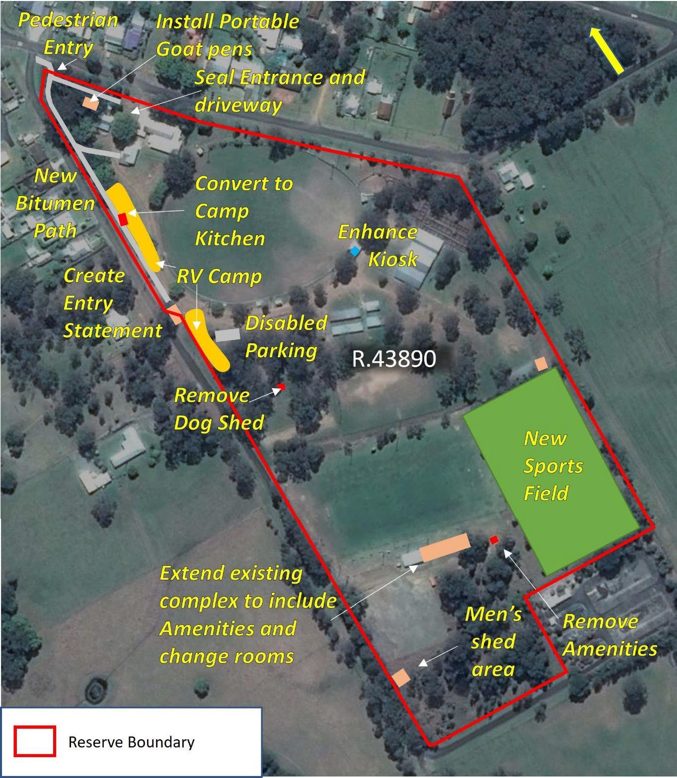
Future improvements to the Reserve (see Figure 16) will:
• Rationalise building infrastructure within the General Community Use area with the objective of reducing the future maintenance burden, sharing facilities between user groups, and spatially improving effectiveness of services provided, including:
o Enhance main kiosk.
o Existing Men’s Shed / Kiosk to be converted to a camp kitchen when a new Men’s Shed is constructed in the southern General Community Use area.
o Dismantling dog shed/storage and encouraging use of marquis for future dog show events, preferably integrated with the sporting fields and proposed amenities (see below).
o Dismantle existing pen structures within the goat pavilion and install portable pen system which can be erected/dismantled to permit additional uses within this area as required.
o Extend the existing Primitive / RV Camp area, to a narrow area south of the entrance gate along the Showground Lane boundary. Obtain development consent and operating approval as a short-term primitive camp site.
o Addressing infrastructure required as part of future plan to improve capacity to accommodate campers and vans.
o Reconstructing entrance area at main entrance, Showground Lane, to cater for truck, smaller vehicle and casual entry.
o Develop plan to reshape existing driveway from entrance to library, with consideration of root systems of existing high-value trees. Seal driveway with bitumen.
o Improve and extend seating for spectators, main arena, by installing two additional small metal “grandstands” around the northern section of the arena, utilising existing natural shade advantages. Install shade cover where required.
o Install seating on the foot-slope above the dog ring.
o Investigate the provision of two car parking spaces for the disabled, immediately south of the Showground Lane entry within reserve. An existing disabled park near library is acknowledged.
o Construct a path which links pedestrian visitors from the town to the main items of infrastructure in conjunction with the Nabiac Street and Showground Lane vicinities
(inside or outside the Showground boundary).23
o Investigate the feasibility of a covered equestrian area, for multiple horse sports.
• In the Sportsground area (southern);
o Improve lighting on main field.
o Construct additional playing fields east of existing main area to cater for increased sporting activity (existing codes, netball).
Where it is proposed to construct or establish a public work24 on reserved or dedicated Crown land, where native title is not extinguished, prior to approval Council will notify and give an opportunity for comment from any representative Aboriginal/Torres Strait Islander bodies, registered native title bodies corporate and registered native title claimants in relation to the land or waters covered by the reservation or lease as required under the Native Title Act 1993.
Where a proposed update of a Park Master Plan, Capital Works Program, Sportsground Action Plan, Sports Facilities Asset Management Plan or any other plan is the approving documentation for a public work on Crown land, that approval will not be given unless the requirements of the Native Title Act 1993 have been addressed including the notification and opportunity to comment noted above.
Any development must comply with the scheme contained in the National Parks and Wildlife Act 1974 for the protection of Aboriginal cultural heritage.
23 These access pathways could be either constructed within the reserve boundary or outside the boundary. The outside option for the Showground Lane (corner Showground Lane and Nabiac Street, to Showground Lane entrance) will require drainage considerations (suggest lateral dish cross section to drain both ways, north and south). The inside option for Nabiac Street (corner Nabiac Street to main entrance Nabiac Street) to accommodate existing trees within boundary. The outside option to enter separate access gate adjacent to main gate Nabiac Street. Both inside options will require new access gate into the reserve at or near corner.
24 A pubic work is defined as:
(a) any of the following that is constructed or established by or on behalf of the Crown, or a local government body or other statutory authority of the Crown, in any of its capacities:
(i) a building, or other structure (including a memorial), that is a fixture; or
(ii) a road, railway or bridge; or
(iia) where the expression is used in or for the purposes of Division 2 or 2A of Part 2 a stock-route; or
(iii) a well, or bore, for obtaining water; or
(iv) any major earthworks; or
(b) a building that is constructed with the authority of the Crown, other than on a lease.
Major earthworks are defined as: earthworks (other than in the course of mining) whose construction causes major disturbance to the land, or to the bed or subsoil under waters.
Council will ensure the facilities on the Reserve are maintained to an appropriate standard. It intends to:
• Maintain the structures and open spaces on the Reserve in accordance with Council’s Asset Management Policy to measured targets within available resources. This in particular includes essential maintenance required to both poultry and produce pavilions, cattle yards, horse stalls, current Men’s Shed / kiosk, and main hall. Further, stipulated requirements of the range of Heritage listed infrastructure items at Reserve will be prioritised as per required maintenance schedule. Compilation of an approved annual maintenance plan is encouraged.
• Continue to monitor the condition of structures on the Reserve and ensure effective maintenance procedures are in place through tenure conditions and Section 355 committee maintenance responsibilities.
• Prepare a safety audit of the site and repair or replace any areas that may impact on public safety.
• Continue to effectively administer Council’s seasonal policy of park occupation policy (MidCoast Council Terms & Conditions for use of Recreational Spaces Procedure 2016) with the prime users of the Reserve’s sportsground and general community use areas.
• Encourage community groups to assist with maintenance of whole of Reserve, particularly through appropriate signage.
• Initiate a Tree Management Plan for the mature species within the General Use area, both in and around the main entrance and camping area, and in particular the ridge and slope carrying mature Ironbark specimens. This Plan should be consistent with requirements for safety, as well as balancing objectives of habitat preservation, and enhancements of vehicle parking space where possible.
• Addressing boundary fence issues where required. Maintain existing (east-west) subdivision fence between Showground Lane and Saleyard Lane (immediately below dog exhibition yard on the west, and below second horse stalls on the east) as an effective means of management of livestock, horses, safety considerations etc. Casual access to proposed (second) playing field during horse preparation/use periods, made possible through access gate.
• Ensure implementation of an effective program to eradicate invasive plant species in Bushland area, to enhance native species and habitat values.
• Ensure appropriate management of playing surfaces on all vegetated sportsgrounds including mowing at suitable time intervals.
• Ensure appropriate slashing/mowing of all grounds in the General Community Use area.
• Ensure the efficient and conservative use of water, pesticides, herbicides and fertilisers across the Reserve, where required.
• Ensure regular collection of rubbish and elevate compliance activities against illegal dumping of rubbish.
• Council officers to continue monitoring for issues of compliance and general site amenity.
• Maintain existing drainage systems across the Reserve to minimise impact of flooding and waterlogging.
• Manage all areas of the Reserve consistent with the relevant Bushfire Management Plan (Nabiac and Failford Fire Mitigation Plan (2007)), in particular prioritising preservation of heritage listed infrastructure items, and fuel loads within the Bushland area.
Council uses signs to regulate the activities carried out on Community Land and to provide educational information so as to provide a safe and enjoyable place for passive and active recreational pursuits.
Whilst signs are a crucial source of information, they have a significant impact on the aesthetics of a reserve. All signs must meet a design standard and be approved by Council. All signs must be sympathetic to their environment in their design, construction and location.
Council uses the Statewide Mutual Best Practice Manual – Signs as Remote Supervision for design of safety signage.
All signage must be placed in accordance with State Environmental Planning Policy No 64 – Advertising and Signage or State Environmental Planning Policy (Exempt and Complying Development Codes) 2008. Signage must also be consistent with the Great Lakes Development Control Plan.
Where a sign requires development consent, Council must approve as owner the lodging of a Development Application prior to assessment by Council in accordance with Schedule 1 Assessment Criteria of SEPP No 64.
Where a sign does not require development consent, Council must approve the sign before erection.
All Council signs erected under Section 632 of the LGA, plus reserve name signs and traffic and safety signs, are permissible.
Proposed Signage
Council will ensure the following signage is on the Reserve:
• Construct suitable entrance area featuring descriptive signage.
• Directional signage for the purposes of guiding the community to required infrastructure and services.
• Signage for safety purposes including speed limitations and evacuation procedures.
A major challenge in the future management of the Reserve, will be to generate income to address increasing costs associated with critical maintenance and new developments, and ongoing activities.
Income may be sourced from the following:
• Council’s GeneralRevenueFund(inaccordancewithannualoperationalbudgets): Where the Reserve is being used for informal casual use, Council will contribute to the maintenance and development of Infrastructure.
• Section94Contributionsspecificallycollectedforcommunityland: This component occurs as ratepayers’ contributions for the general use of community land for community well-being.
• Userpaysforminorinfrastructureworksassociatedwithsomesportingfacilities: This occurs through fund raising by the relevant body including memberships, minor sales and raffles etc. and aims at achieving tailoring surrounds and layout which suit and are compatible with the event or activity.
• Communitycontributionsbyway ofcommunitygroupprojects(eg.,Landcare,Rotary,Lions Club): This occurs through grants either sourced externally, and/or contributed locally by the group (eg., for the purposes of environmental works, social and intellectual well-being etc.).
• Grant and loan funding from either Commonwealth or State Governments: The implementation of the management structure will allow Primary users to apply for funds from a number of Government bodies with the concurrence of Council. Council may also apply for these funds. A limited number of funding opportunities exist from government programs.
Division 12.5 of the CLMA provides for the Crown Reserve Improvement Fund25 (CRIF) Section 12.29 provides that:
(1) The following may be paid from the Crown Reserves Improvement Fund:
(a) the cost of the purchase or acquisition of land required for Crown reserves,
(b) the cost of the maintenance, improvement or development of Crown reserves (whether by direct expenditure or by grants, loans or advances to the managers of the Crown reserves), but only if the payment is made with the approval of the Minister…
Competitive applications to receive funding from the CRIF are called for on an annual basis early each year by the DPE-CL. Further information about this process can be found at DPE-CL’s website at www.industry.nsw.gov.au/lands.
• Income from commercial operations: Where tenures are involved, income will arise as per details in the revenue-split in the corresponding agreement. Less formally, income may result from casual occupation, such as Reserve use fees, including those associated with camping and motor home visits (see 11.2 below).
25 The Crown Reserve Improvement Fund is the successor to the former Public Reserve Management Fund created under the former Public Reserves Management Fund Act 1987.
In order to address the outstanding and future maintenance requirements at the Reserve, and permit any required new developments as proposed in this PoM, it is important that all income which is generated from the Reserve be returned to the Reserve, and that this should be clearly demonstrated in the financial statements of the 355 Committee. Ensuring appropriate rental and fees for formal use of the site will assist in the maintenance of specialised infrastructure.
Council records indicate the Reserve is running at an annual financial loss, which means that new and emerging opportunities require capture and implementation. The two most favourable and obvious business directions are the attraction of new users (groups and casual) and growth in the Camping and Recreational Vehicle use of the Reserve.
This is an activity not formally approved for this Reserve. Development of Camping facilities would require approval under the Environmental Planning and Assessment Act 1979. However, it continues to represent an opportunity to take advantage of current growth in that market place, without significant impact on existing uses and existing businesses. Short-term primitive camping is permissible, subject to approval by way of Council Resolution and having the required infrastructure in place.
Council may be able to create a capacity for the Reserve to up to 20 sites (with a primitive camp ground approval) in accordance with the Local Government (Manufactured Home Estates, Caravan Parks, Camping Grounds and Moveable Dwellings) Regulation 2021 given the Reserve area of around 11.82 Ha.
Maximising the area available within the Reserve footprint will be complemented by several of the proposed actions associated with new works and maintenance in the General Use area, such as rationalising existing buildings, creation of a play area with BBQ facilities and tree maintenance and management (see 10.8 and 10.9 above).
Provision of facilities will increase the patronage of the site. Over time, as usage of the Primitive / RV Camps increases, consideration may be given to the conversion of Men’s Shed /Kiosk into a camp kitchen. The placement of an RV dump either on-site or elsewhere within Nabiac and on the eastern side of the Pacific Highway should be considered.
Council may also increase activity at the site for larger groups by having proforma applications available for event organisers to submit single event applications.
As noted in section 1 the town of Nabiac sits in a prime location within the newly created MidCoast Council area. It is situated close to the administrative centres of Forster, Taree and Gloucester.26 It is also located in an ideal position between large administration centres of Port Macquarie, Coffs Harbour and Newcastle to be able to provide an on-Highway facility for day functions.
The hall and kitchen facilities, with a variation in room sizes, provides an opportunity to create a function facility to cater to a variety of corporate and social events. To facilitate this opportunity, as an all year location, Council may need to install an appropriate air-conditioning system and develop catering agreements with local businesses.
Council, both as an owner and as a user, may need to drive the growth in the use of the facility.
Although this Reserve already performs strongly in this regard, there is a growing market in city-based communities who are prepared to travel to enjoy “the bush” and all it has to offer recreationally and socially, in particular, those that typify rural Australia. The “three-hour travel window” from the main centres of population (Sydney, Newcastle areas) places Nabiac in a strong strategic position to develop this market. Nabiac Showground also is unique in its depiction of historically important infrastructure, typical of a bygone era, which is generally attractive to many visitors particularly those from growth areas.
Construction of facilities to cater for multiple uses will also increase patronage of the Reserve. Examples of multiple use constructions may include construction of BBQ facilities within the General Use area which may double for sporting and community events, and Casual and RV users. Development of multipurpose sporting facilities which will encourage new and emerging sports (such as netball, various horse sports) is encouraged.
Table 4 sets out a number of actions required to implement the identified Management Strategies and Performance Targets within the Reserve. These actions are the means of achieving the objectives of the PoM.
A clear indication of how the completion of the aims will be assessed is also provided in the table under Performance Evaluation.
To encourage, promote and facilitate recreational pursuits in the community involving organised and informal sporting activities and games.
Complete works in accordance with approved Operational Plans.
Capitalise on good relationships with district sporting bodies currently using the sportsground, and on opportunities with outside bodies, ensuring greater use of the sportsground.
Continue to maintain the oval surfaces and associated infrastructure in accordance with appropriate agronomic
i. Dismantle and replace existing amenities block, to include space for storage of equipment and change rooms.
ii. Improve/reconstruct the servery/bar area and shared club rooms, to cater for all sporting needs. Combine into single complex.
iii. Implementing improved and more capacious seating for spectators, main arena, by installing two additional small metal “grandstands” around the northern section of the arena, utilising existing natural shade advantages. Install shade cover where required.
iv. Improve lighting on main field to permit night fixtures.
v. Construct additional playing fields east of existing main area to cater for increased sporting activity (existing codes, netball).
vi. Continue to effectively administer Council’s seasonal policy of park occupation (MidCoast Council Terms & Conditions for use of Recreational Spaces Procedure 2016) with users of the site’s sportsground.
vii. Ensure appropriate management of playing surfaces on all vegetated sportsgrounds including mowing at suitable time intervals.
viii. Encourage a positive relationship with the NSMC and users through the establishment of clear expectations, and communications.
ix. Establish appropriate tenure and usage arrangements for existing and new users, at recommended/appropriate rent and hire fees.
• All new works constructed to budget and satisfaction of sporting community/NSMC.
• Sportsground enjoys increase in usage by catchment area residents and beyond.
• Sportsground is used to capacity for organised sporting events.
• Grounds are managed in accordance with prescribed Council standards.
• Where possible, sportsground is catering for emerging trends and needs in organised sports.
• All feedback from user groups/sporting bodies to NSMC and Council is positive.
practices and standards.
x. Ensure that the requirements of any lease or usage agreement are met.
xi. Encourage sporting clubs and organisations to actively participate in the maintenance of the facilities they use, as per agreement.
xii. Where necessary, develop guidelines to clarify and strengthen the requirement for sporting clubs to maintain orderly and tidy surrounds at all times.
xiii. Maintain sporting field surfaces using sound principles of fertiliser use, aeration and topdressing as required.
xiv. Ensure bins are provided and routinely removed.
xv. NSMC to proactively attract new activities and sports to a multi-use Sportsground (including existing activities currently conducted elsewhere on the showground area eg Dog Show, Men’s Shed) by promoting the facility through Council papers and media.
xvi. Regular inspections by Council officers.
xvii. Signage in accordance with Schedule 1 SEPP 64 and approved by Council.
To ensure that such activities are managed having regard to any adverse impact on nearby residences.
Build and maintain good rapport with neighbourhood.
To promote, encourage and provide for the use of the land, and to provide facilities on the land, to meet the current and future needs of the local community and of the wider public:
• in relation to public recreation and the physical, cultural and intellectual welfare or
• Manage existing assets into the future through appropriate assessment and planning.
• Complete necessary works in accordance with approved Operational Plans.
• Enable and promote free and
xviii. Council to communicate with residents immediately close by, on a needs basis, especially regarding major events.
xix. Regular inspections by Council officers.
• Numbers of positive responses and complaints from sporting bodies, and residents.
i. Enhance main kiosk.
ii. Existing Men’s Shed / kiosk to be converted to a camp kitchen when a new Men’s Shed is constructed in the southern section of the reserve noted in Figure 15.
iii. Dismantle dog shed/storage and encourage use of marquis for future dog show events.
iv. Dismantle existing pen structures within the goat pavilion and install portable pen system (under existing roof structure) which can be erected/dismantled to permit additional uses within this area as required
v. Extend the existing Primitive / RV Camp area, to a narrow area south of the entrance gate along the Showground Lane boundary. Obtain development consent and operating approval as a short-term primitive camp site.
vi. Reconstruct/improve entrance area at main entrance, Showground Lane, to cater for truck, smaller vehicle and casual entry.
vii. Develop plan to reshape existing driveway from entrance to library, with
• All new and maintenance works are completed in accordance with works plans.
• Community enjoying unfettered access for casual use of new recreational facilities.
• Grounds are kept tidy and orderly.
• All feedback from Reserve users to NSMC and Council is positive.
development of individual members of the public, and
unconstrained access to casual users of the area categorised General Community Use.
consideration of root systems of existing high-value trees. Seal driveway with bitumen.
viii. Add two car parking spaces for the disabled, immediately south of the Showground Lane entry within reserve.
ix. Install seating on the foot-slope above the dog ring.
x. Address boundary fence issues where required.
xi. Maintain existing (east-west) subdivision fence between Showground Lane and Saleyard Lane as an effective means of management of livestock, horses, safety considerations etc. during cross country etc events.
xii. Increase and improve seating for spectators, main arena.
xiii. Address infrastructure required as part of future plan to improve capacity to accommodate campers and vans.
xiv. Develop a Tree Management Plan for older tree areas around main infrastructure, to address issues of parking space, safety (noting senescent and dangerous mature Ironbark trees), aesthetics and environmental management/habitat values. Plan to include management of existing trees and replanting options.
xv. Construct a pathway which links pedestrian visitors from the town to the Showground infrastructure.
xvi. Grow the use of the community hall facility through the installation of an air-conditioning system and promotion as a corporate and social function centre.
xvii. Maintain the structures and open spaces on the Reserve in accordance with Council’s Asset Management Policy to measured targets within available resources.
xviii. Implement a safety audit of the site and repair or replace any areas that may impact on public safety.
xix. Ensure appropriate slashing/mowing of all grounds in the General Community Use area.
xx. Ensure the efficient and conservative use of water, pesticides, herbicides and fertilisers across the Reserve, where required.
xxi. Ensure regular collection of rubbish and elevate compliance activities against illegal dumping of rubbish.
xxii. Council officers to continue monitoring for issues of compliance and general Reserve state.
xxiii. Maintain existing drainage systems across the Reserve to minimise impact of flooding and waterlogging.
xxiv. Undertake a Safety Audit for the Reserve.
xxv. Erect required signage in accordance with Schedule 1 SEPP 64 and approved by Council.
xxvi. Reignite and Implement proposed management structure (NSMC) and communications strategy.
• in relation to purposes for which a lease, licence or other estate may be granted in respect of the land.
• Build on relationships with existing and new users of the various facilities in order to draw more people to the area categorised General Community Use both as casual and paying users.
xxvii. Seek approval for primitive camp ground in accordance with the Local Government (Manufactured Home Estates, Caravan Parks, Camping Grounds and Moveable Dwellings) Regulation 2021.
xxviii. Subject to approval as per above, manage the camping area in accordance with the approval under Section 68 of the LGA.
xxix. Establish appropriate tenure arrangements for existing and new users, at recommended/appropriate rent and hire fees.
xxx. Encourage community groups to assist with maintenance of whole of site, particularly through appropriate signage.
xxxi. Continue to effectively administer Council’s policy of park occupation (MidCoast Council Terms & Conditions for use of Recreational Spaces Procedure 2016) with users of the Reserve’s General Community Use areas.
xxxii. Encourage a positive relationship with the NSMC and Primary Users and the establishment of clear communications and expectations.
xxxiii. Continue to monitor the condition of structures on the Reserve and ensure effective maintenance procedures are in place through tenure conditions and Section 355 committee (NSMC) maintenance responsibilities.
xxxiv. Continue to implement Council’s Community Markets Policy.
• Primary and other users are content with tenuring arrangements and business plan is working well with all, including clarity and communication.
• General Community Use area has attracted new commercial users.
To ensure the ongoing ecological viability of the land by protecting the ecological biodiversity and habitat values of the land, the flora and fauna (including invertebrates, fungi and microorganisms) of the land and other ecological values of the land.
Retain and enhance all native vegetation within the Bushland area.
i. Adequately consider any proposed development on or near the Bushland area, ensuring the objectives of management of this area are not compromised.
ii. Use chemicals (fertilisers, weedicides) responsibly.
• Ensure rubbish is routinely removed.
• Regular inspection by Council officers.
• Apply Council’s Tree Management Plan as required.
Biodiversity values and natural habitat maintained and/or showing positive responses to on-ground actions.
To restore degraded bushland. Adopt program of effective weed control in the understory.
iii. As required, undertake a targeted control of priority (environmental and noxious) weeds which threaten the native shrublands and trees.
iv. Implement the relevant components of the Nabiac and Failford Fire Mitigation Plan (2007).
v. Regular inspection by Council officers.
• Weed control, reestablishment of bushland maintained and/or showing positive responses to onground action.
• Bushfire fuel levels are adequately managed.
To protect existing landforms such as natural drainage lines, watercourses and foreshores.
To protect bushland as a natural stabiliser of the soil surface.
Retain and enhance all native vegetation within the Bushland area.
vi. Adequately consider any proposed development on or near the park, ensuring any of the objectives for management of areas categorised Bushland, are not compromised.
vii. As required, adopt appropriate weed control strategies.
viii. Regular inspection by Council officers.
• Weed control, reestablishment of bushland maintained and/or showing positive responses to onground action.
Retain and enhance all native vegetation within the Bushland area.
ix. Adequately consider any proposed development on or near the Bushland area, ensuring the objectives of park management are not compromised.
x. As required, adopt appropriate weed control strategies.
xi. Regular inspection by Council officers.
Note: Only 4 of 7 Management Objectives for areas categorised as Bushland are relevant to this PoM and as such actively addressed.
• Stabilisation of soil surface is not impaired, or shows positive responses to onground actions.
Community consultation is an important source of information necessary to provide an effective Plan of Management for Community Land, and is a requirement under Section 38 of the LGA. MidCoast Council’s Community Engagement Policy, outlines the principles and activities with the participating community which guide Council’s decision-making processes. Such participation creates the opportunity for interested parties to become actively involved in the development of a Plan which reflects the needs, opinions and priorities of people using the Reserve.
Prior to formal commencement of this PoM, discussions with all user groups at the Nabiac Showground were conducted and views on a range of issues were captured in a standard StrengthsWeaknesses-Opportunities-Threats (SWOT) format. Users were also asked to compile prioritised needs and aspirations for the Reserve.
The outcomes of the SWOT analysis appear in Appendix 3.
Council will undertake further consultation in accordance with its Communication and Consultation Strategy as required under the act.
This PoM was placed on public exhibition from 7 October – 20 November 2022, in accordance with the requirements of section38 ofthe LGA. Atotal of20submissions were received.Council considered these submissions before adopting the PoM. In accordance with section 39 of the LGA, prior to being placed on public exhibition, the draft PoM was referred to the Department of Planning and Environment – Crown Lands, as representative of the State of New South Wales, which is the owner of the Reserve. Council has included in the plan any provisions that have been required by the Department of Planning and Environment – Crown Lands.
In accordance with Section 70B of the Crown Land Management Regulation 2018 Council will obtain consent of the Minister administering the CLMA prior to adopting this PoM (see Appendix 5).
1) Core Objectives for Categories of Community Land.
2) Leases, Licences and Development of Community Land – MidCoast Council.
3) Sources of Information used to derive Vision, Management Directions and Planning Principles.
4) State Environmental Planning Policies which are relevant to the Nabiac Showground
5) Key steps in preparing the first PoM for Crown Reserves.
Community Land Management Plan 2012: Great Lakes Council.
Community Strategic Plan 2016-2021. Coordinated by Nabiac Village Futures Group 2015.
Council’s Condition Report. GHD (April 2017).
Crown Land Management Act 2016: http://www.legislation.nsw.gov.au/
Department of Local Government 2000: Practice Note No.1, Public Land Management, Amended May 2000.
Espade; Office of Environment and Heritage: www.environment.nsw.gov.au/eSpade2Webapp//
Local Environmental Plan 2014: Great Lakes Council.
Local Government Act, 1993: Amended by the Local Government (Community Land Amendment) Act 1998. NSW Government: http://www.legislation.nsw.gov.au/
NSW Heritage Office inventory form Na 25, No. 103357 Garry Smith 2009.
Recreation and Open Space Strategy 2006: Great Lakes Council.
Terms and Conditions for Use of Recreational Spaces 2016: MidCoast Council.
The core objectives for management of community land categorised as a natural area are:
(a) to conserve biodiversity and maintain ecosystem function in respect of the land, or the feature or habitat in respect of which the land is categorised as a natural area, and
(b) to maintain the land, or that feature or habitat, in its natural state and setting, and
(c) to provide for the restoration and regeneration of the land, and
(d) to provide for community use of and access to the land in such a manner as will minimise and mitigate any disturbance caused by human intrusion, and
(e) to assist in and facilitate the implementation of any provisions restricting the use and management of the land that are set out in a recovery plan or threat abatement plan prepared under the Biodiversity Conservation Act 2016 or the Fisheries Management Act 1994.
The core objectives for management of community land categorised as a sportsground are:
(a) to encourage, promote and facilitate recreational pursuits in the community involving organised and informal sporting activities and games, and
(b) to ensure that such activities are managed having regard to any adverse impact on nearby residences.
The core objectives for management of community land categorised as a park are:
(a) to encourage, promote and facilitate recreational, cultural, social and educational pastimes and activities, and
(b) to provide for passive recreational activities or pastimes and for the casual playing of games, and
(c) to improve the land in such a way as to promote and facilitate its use to achieve the other core objectives for its management.
(1) The core objectives for management of community land categorised as an area of cultural significance are to retain and enhance the cultural significance of the area (namely its Aboriginal, aesthetic, archaeological, historical, technical or research or social significance) for past, present or future generations by the active use of conservation methods.
(2) Those conservation methods may include any or all of the following methods:
(a) the continuous protective care and maintenance of the physical material of the land or of the context and setting of the area of cultural significance,
(b) the restoration of the land, that is, the returning of the existing physical material of the land to a known earlier state by removing accretions or by reassembling existing components
without the introduction of new material,
(c) the reconstruction of the land, that is, the returning of the land as nearly as possible to a known earlier state,
(d) the adaptive reuse of the land, that is, the enhancement or reinforcement of the cultural significance of the land by the introduction of sympathetic alterations or additions to allow compatible uses (that is, uses that involve no changes to the cultural significance of the physical material of the area, or uses that involve changes that are substantially reversible or changes that require a minimum impact),
(e) the preservation of the land, that is, the maintenance of the physical material of the land in its existing state and the retardation of deterioration of the land.
(3) A reference in subsection (2) to land includes a reference to any buildings erected on the land.
The core objectives for management of community land categorised as general community use are to promote, encourage and provide for the use of the land, and to provide facilities on the land, to meet the current and future needs of the local community and of the wider public:
(a) in relation to public recreation and the physical, cultural, social and intellectual welfare or development of individual members of the public, and
(b) in relation to purposes for which a lease, licence or other estate may be granted in respect of the land (other than the provision of public utilities and works associated with or ancillary to public utilities).
The core objectives for management of community land categorised as bushland are:
(a) to ensure the ongoing ecological viability of the land by protecting the ecological biodiversity and habitat values of the land, the flora and fauna (including invertebrates, fungi and micro-organisms) of the land and other ecological values of the land, and
(b) to protect the aesthetic, heritage, recreational, educational and scientific values of the land, and
(c) to promote the management of the land in a manner that protects and enhances the values and quality of the land and facilitates public enjoyment of the land, and to implement measures directed to minimising or mitigating any disturbance caused by human intrusion, and
(d) to restore degraded bushland, and
(e) to protect existing landforms such as natural drainage lines, watercourses and foreshores, and
(f) to retain bushland in parcels of a size and configuration that will enable the existing plant and animal communities to survive in the long term, and
(g) to protect bushland as a natural stabiliser of the soil surface.
The core objectives for management of community land categorised as wetland are:
(a) to protect the biodiversity and ecological values of wetlands, with particular reference to their hydrological environment (including water quality and water flow), and to the flora, fauna and habitat values of the wetlands, and
(b) to restore and regenerate degraded wetlands, and
(c) to facilitate community education in relation to wetlands, and the community use of wetlands, without compromising the ecological values of wetlands.
The core objectives for management of community land categorised as an escarpment are:
(a) to protect any important geological, geomorphological or scenic features of the escarpment, and
(b) to facilitate safe community use and enjoyment of the escarpment.
The core objectives for management of community land categorised as a watercourse are:
(a) to manage watercourses so as to protect the biodiversity and ecological values of the instream environment, particularly in relation to water quality and water flows, and
(b) to manage watercourses so as to protect the riparian environment, particularly in relation to riparian vegetation and habitats and bank stability, and
(c) to restore degraded watercourses, and
(d) to promote community education, and community access to and use of the watercourse, without compromising the other core objectives of the category.
The core objectives for management of community land categorised as foreshore are:
(a) to maintain the foreshore as a transition area between the aquatic and the terrestrial environment, and to protect and enhance all functions associated with the foreshore’s role as a transition area, and
(b) to facilitate the ecologically sustainable use of the foreshore, and to mitigate impact on the foreshore by community use.
A lease is generally required where exclusive control of all or part of an area by a party is proposed or desirable in the interests of the management of the area. A licence is generally required where intermittent or short-term occupation or control of an area is proposed. A number of licences may apply at the same time provided there is no conflict of interest.
The granting of leases and licences can occur for the use of Sportsgrounds (including playing fields, courts, clubrooms, change rooms, storage space and canteens). This PoM expressly authorises the following, subject to the core objectives of the LGA:
• Seasonal licences for competitive events.
• Licences for schools to use exclusively on weekends.
• Licences for the casual hire of sportsgrounds for sporting and community events including organised fetes, festivals, fairs, circuses, charity events, movies, musicals, community singing events, parades and performances, and may include stall holders engaged in trade.
• Licences for small scale private sector events such as markets, promotional events, parties, large group picnics, family reunions, weddings, filming and photography.
• Licences for periodic exclusive use, where a sport’s association has committed capital contribution to the facility.
• Although the granting of liquor licences is subject to other approvals, this PoM expressly allows Council to give permission as landowner for liquor licences subject to other approvals.
• Lease for the use of a radio transmission tower, including associated infrastructure for use by telco companies and amateur radio clubs.
• Lease/licence or other estate may be granted for the purpose as carbon sinks and the accounting of carbon for the purposes of carbon trading.
The granting of leases/licences for the use of areas categorised as GeneralCommunityUse include such facilities as community centres and halls, clubrooms and part or all of other Council owned facilities. This PoM expressly authorises the following, subject to the core objectives of the LGA:
• Annual licences or hiring agreements with regular user groups of community centres and halls for, but not limited to, various forms of recreational classes and community group meetings (eg., dancing, martial arts, aerobics, arts, church groups, sports clubs, charity groups, community service clubs, neighbourhood centres, scouts/guides).
• Casual hiring of community centres and halls (when not in use by regular hirers) for the above purposes and small scale private sector events including but not limited to markets, promotional events, social functions, parties, reunions, weddings, filming and photography.
• Leases giving exclusive use, where a community organisation has committed capital contribution to the facility, undertakes full maintenance responsibilities and/or requires exclusivity due to its type of
use eg., woodworking shed, etc., but not limited to various forms of recreational classes, educational classes and community group meetings.
• Although the granting of liquor licences is subject to other approvals, this PoM expressly allows Council to give permission as landowner for liquor licences subject to other approvals.
• Leases for the use of a radio transmission tower, including associated infrastructure for use by telco companies and amateur radio clubs.
• Lease/licence or other estate may be granted for the purpose as carbon sinks and the accounting of carbon for the purposes of carbon trading.
The LGA imposes restrictions on the ability of Council to grant leases, licences or other estates over community land categorised as NaturalArea. Council may only grant a lease, licence or other estate if it is authorised under this PoM, and the purpose is consistent with the core objectives of the land category and the lease/licence is for a purpose specified in Section 47B of the LGA.:
• only in the use or erection of those buildings or structures listed below;
o Walkways
o Pathways
o Bridges
o Causeways
o ObservationPlatforms
o Signs, or
• to authorise the erection and use of those buildings or structures for the following;
o Informationkiosks
o Refreshment kiosks
o Work sheds/storage sheds required in connection with the maintenance of the land, toilets or rest rooms.
The Local Government (General) Regulation 2021 provides a number of uses for which Council can grant a short-term casual licence on Council’s community land where there is no erection of a permanent building or structure:
• The playing of musical instruments, or singing, for a fee or reward
• Engaging in a trade or business
• The playing of a lawful game or sport
• Delivering a public address
• Commercial photographic sessions
• Picnics and private celebrations such as weddings and family gatherings
• Filming for cinema or television, and
• The agistment of stock.
Fees may apply for some casual and short term licences. Fees are detailed in Council’s annual fees and charges.
ActivitiesonCommunityLandwhichrequireApprovalfromCouncil
Section 68 of the LGA requires that a person obtain prior approval from Council to carry out the following activities on Community land:
• Engage in a trade or business.
• Direct or procure a theatrical, musical or other entertainment for the public.
• Construct a temporary enclosure for the purpose of entertainment.
• For a fee or reward, play a musical instrument or sing.
• Set up, operate or use a loudspeaker or sound amplifying device.
• Deliver a public address or hold a religious service or public meeting.
Approval to undertake such activities is currently managed through the Special Event Application process or Commercial Use of Reserve Policy.
• Council’s broad strategic intent in the management of all of its community land by the year 2030, are summarised in the following two key directions:
o Embracing and Protecting our Natural Environment: Protecting the Natural Environment while addressing the challenges of population growth.
o Planning the Balance: Providing appropriate services and infrastructure, community facilities and opportunity for residents to continue to enjoy their existing lifestyle balanced with the impact of increases in population, additional development and influx of tourists.
• From a scoping discussion with community Reserve users (conducted as part of the development of this PoM (see Swot Analysis following), three guiding and intrinsic values of the Nabiac Showground emerged:
o The Nabiac Showground is a significant physical epicentre for this subcoastal community.
o There is overwhelming support for the role of the Reserve in the Nabiac community, and strong acknowledgement of the service it provides for essential bonding and connectivity often across diverse interest groups.
o The Reserve is well positioned within the “three-hour travel window” from the metropolis, therefore creating the potential to capitalise on increased visitations to the many rural-based events, and continue to build a bridge between the “city and the bush”
• The Community Strategic Plan (2016-202128) completed by the Nabiac Village Futures Group (NVFG) describes a vision for the village as “A Vibrant Rural Village”, with the Mission: “To aid in the further creation, and maintenance of a family friendly rural village with improved facilities for all ages”. The inextricable linkages between the broader community and the Reserve are acknowledged in the guiding principles within this PoM.
• Consistent with the point above, it is noted that Council’s Recreation and Open Space Strategy (ROSS) acknowledges Nabiac Showground as a Regional Facility which has the potential to attract significant numbers of visitors from considerable distances within a Regional Catchment.
Nabiac Showground User Groups Workshop, Wednesday 20th July (22 attendees)
Strengths
• Location
• Well established
• Amount of space available
• Good parking outside
• Amenities in good condition
• Strong community participation
• Rural atmosphere
• Multi-purpose
• Networks beyond community
• Proximity to highway – 3 hours to Sydney
• Village amenity
• History
• Importance to town – provides things to do
• Geographical centre of Council
• Track record
• Frontage access
• No neighbour issues
• No showground in Forster
Weaknesses
• Sporting facilities /Change rooms
• Amenities/ Both entry pedestrian
• Drainage / Sports ground, large vehicles
• Parking for major event, Farmers Markets
• Pedestrian link to town
• Internal walkways and paths
• Trees – falling limbs
• Hall cold in winter
• Age – maintenance required
• Town signage / Advertising ‘What’s On’
• No town camping facility
• Mowing maintenance
• Young volunteers
• People coming from city
• Community grant funding
Opportunities
• Camping / RV development, manage bookings, utilise space (can handle large events)
• Cooking classes
• Plan of usages – register, central control –Council or Committee
• “3-hour window” from city – attraction
• Make hall warmer – more attractive/usable
• Look – aesthetics - caretake or employee?
• More storage required – Markets
• Clubhouse for sports
• More power for Markets
• Night Markets option
• Portable stage – for reserve
• Sport extension * income avenues
• More systemised way of facility use – Team Pen/ Rodeo/ Horse area. To avoid poor coordination and advice
Threats
• Closure of facilities (Library)
• Loss of volunteer support
• OHS Insurance – trees, safety hazardous chemical protection
• Complacency / time of volunteers
• Loss of major events (space/wear and tear)
• Aging infrastructure
State Environmental Planning Policy (Transport & Infrastructure) 2021 provides that certain types of works do not require development consent under Part 4 of the Environmental Planning and Assessment Act 1979 (EP&A).
Clause 20 of SEPP (Transport & Infrastructure 2021) provides that a range of works are “exempt development” when carried out for or on behalf of a public authority (including MidCoast Council). These works are itemised in Schedule 1 of the SEPP and include paths and ramps for disabled access, fencing, firefighting emergency equipment, small decks, prefabricated sheds of up to 30m2 in area, retaining walls up to 2m in height, landscaping including paving and access tracks, minor external and internal alterations to buildings, open car parks (size is not specified) and demolition of buildings covering an area of up to 100m2.
by a Crown land manager:
Clause 66 of the SEPP (Transport & Infrastructure 2021) also provides that the following is exempt
(a) construction or maintenance of
(i) walking tracks, raised walking paths (including boardwalks), ramps, stairways or gates, or
(ii) bicycle-related storage facilities, including bicycle racks and other bicycle parking facilities (except for bicycle paths), or
(iii) handrail barriers or vehicle barriers, or
(iv) ticketing machines or park entry booths, or
(v) viewing platforms with an area not exceeding 100m2, or
(vi) sporting facilities, including goal posts, sight screens and fences, if the visual impact of the development on surrounding land uses is minimal, or
(vii) play equipment if adequate safety measures (including soft landing surfaces) are provided and, in the case of the construction of such equipment, so long as the equipment is situated at least 1.2m away from any fence, or
(viii) seats, picnic tables, barbecues, bins (including frames and screening), shelters or shade structures, or
(ix) portable lifeguard towers if the footprint of the tower covers an area no greater than 20 square metres,
(b) routine maintenance of playing fields and other infrastructure, including landscaping,
(c) routine maintenance of roads that provide access to or within those playing fields, including landscaping.
development if carried out out without
Clause 65 of the SEPP (Transport & Infrastructure 2021) provides that Development for any purpose may be carried consent on Crown managed land, by or on behalf of a Crown land manager of the land if the development is for the purposes of implementing a plan of management adopted for the land in accordance with the Local Government Act 1993. Further, any of the following development may be carried out by or on behalf of a council without consent on a public reserve under the control of or vested in the council:
(a) development for any of the following purposes:
(i) roads, pedestrian pathways, cycleways, single storey car parks, ticketing facilities, viewing platforms and pedestrian bridges,
(ii) recreation areas and recreation facilities (outdoor), but not including grandstands, (iii) visitor information centres, information boards and other information facilities, (iv) lighting, if light spill and artificial sky glow is minimised in accordance with the Lighting for Roads and Public Spaces Standard, (v) landscaping, including landscape structures or features (such as art work) and irrigation systems, (vi) amenities for people using the reserve, including toilets and change rooms, (vii) food preparation and related facilities for people using the reserve, (viii) maintenance depots, (ix) portable lifeguard towers,
(b) environmental management works,
(c) demolition of buildings (other than any building that is, or is part of, a State or local heritage item or is within a heritage conservation area).
State Environmental Planning Policy (Exempt and Complying Development Codes) 2008
State Environmental Planning Policy (Exempt and Complying Development Codes) 2008 (SEPP Exempt) provides that certain types of works do not require development consent under Part 4 of the EP&A Act. The General Exempt Development Code is set out in Division 1 of the SEPP, providing the limitations and conditions of the exemptions. They include:
• Access Ramps
• Advertising and signage
• Aerials, antennae and communication dishes
• Air-conditioning units
• Animal shelters
• Aviaries
• Awnings, blinds and canopies
• Balconies, decks, patios, pergolas, terraces and verandahs
• Barbecues and other outdoor cooking structures
• Bollards
• Charity bins and recycling bins
• Earthworks, retaining walls and structural support
• Fences
• Flagpoles
• Footpaths, pathways and paving
• Fowl and poultry houses
• Garbage bin storage enclosure
• Hot water systems
• Landscaping Structures
• Minor building alterations
• Mobile food and drink outlets
• Playground equipment
• Screen enclosures
• Sculptures and artworks
• Temporary uses and structures
• Waste storage containers
Section 1-16 of Division 2 of the SEPP provides the General Requirements for exempt development.
State Environmental Planning Policy (Vegetation in Non-Rural Areas) 2017
The State Environmental Planning Policy (Vegetation in Non-Rural Areas) 2017 (Vegetation SEPP) is one of a suite of Land Management and Biodiversity Conservation (LMBC) reforms that commenced in New South Wales on 25 August 2017. The Vegetation SEPP (the SEPP) works together with the Biodiversity Conservation Act 2016 and the Local Land Services Amendment Act 2016 to create a framework for the regulation of clearing of native vegetation in NSW.
The SEPP will ensure the biodiversity offset scheme (established under the Land Management and Biodiversity reforms) will apply to all clearing of native vegetation that exceeds the offset thresholds in urban areas and
environmental conservation zones that does not require development consent.
The aim of State Environmental Planning Policy No. 21 – Caravan Parks is to encourage:
• the orderly and economic use and development of land used or intended to be used as a caravan park catering exclusively or predominantly for short-term residents (such as tourists) or for long-term residents, or catering for both, and
• the proper management and development of land so used, for the purpose of promoting the social and economic welfare of the community, and
• the provision of community facilities for land so used,
• the protection of the environment of, and in the vicinity of, land so used
The strategies by which that aim is to be achieved are:
• by requiring that development consent be obtained from the local Council for development for the purposes of caravan parks,
• by providing that development consent may be granted that will authorise the use of sites for shortterm stays (whether or not by tourists) or for long-term residential purposes, or for both,
• by requiring that development consent be obtained from the local Council for the subdivision of land for lease purposes under section 289K of the Local Government Act 1919.
State Environmental Planning Policy No 64—Advertising and Signage
State Environmental Planning Policy No. 64 Advertising and Signage aims:
• to ensure that signage (including advertising):
(i) is compatible with the desired amenity and visual character of an area, and
(ii) provides effective communication in suitable locations, and
(iii) is of high-quality design and finish,
• to regulate signage (but not content) under Part 4 of the Act, and
• to provide time-limited consents for the display of certain advertisements, and
• to regulate the display of advertisements in transport corridors, and
• to ensure that public benefits may be derived from advertising in and adjacent to transport corridors.
This Policy does not regulate the content of signage and does not require consent for a change in the content of signage.
KEYSTEPSINPREPARINGTHEFIRSTPOMFORCROWNRESERVES.
(from Page 5 – Developing plans of management for community land Crown reserves - NSW Department of Planning and Environment).