13 minute read
3. Working with the Planning System


The planning system in NSW, supports a complicated and multi- tiered range of local, regional and State requirements. This Housing Strategy seeks to respond to and work within the current planning system as effectively as possible. The context of the current situation is outlined in this section.
Local Planning Context
The Housing Strategy sets fresh directions from which to consolidate the three Local Environmental Plans (LEPs) being:
o Great Lakes Local Environmental Plan 2014
o Greater Taree Local Environmental Plan 2010
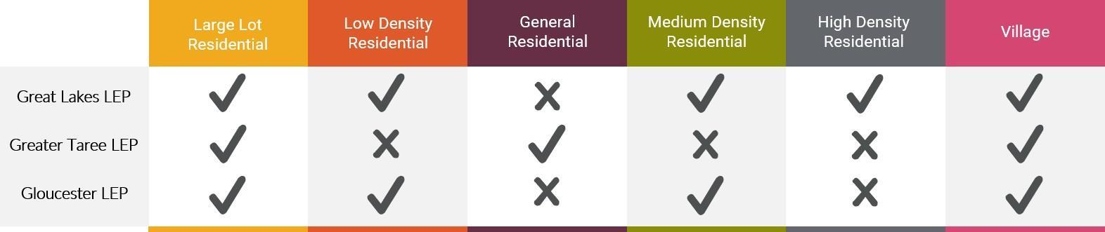
o Gloucester Local Environmental Plan 2010 Each of the current LEPs utilises the suite of residential zones differently, meaning that the MidCoast Council currently applies three different approaches to their planning for housing. This situation creates confusion in the community and results in inconsistent decisions being made depending on where developments are proposed. The current zones used in each of the three existing LEPs is shown below.
As well as the differences in the number of the zones used by each LEP, there are also significant differences in the way the same zones are used. For example, development allowed in the Low Density Residential zone differs considerably between the Great Lakes and Gloucester LEPs with one allowing a much wider range of development, which is similar to the General Residential zone used in Greater Taree. This can confuse the situation and highlight that a new consistent and more transparent suite of zones is needed.
Figure 5: Current use of residential zones by existing Local Environmental Plans
Regional and State level context
At the State Government level, there is also a wide range of planning activities that are occurring. Many of these impact on local government controls and need to be considered in the context of using the suite of residential zones.
The Hunter Regional Plan 2036 provides initial directions for future planning. The Regional Plan established a target for housing delivery of 5,000 dwellings by 2036, an approximate 10% increase.
The State Government also introduced a number of planning "reforms" in recent times, including:
o A Low-Rise Medium Density Housing Code to encourage increased density in a low scale (two storey) setting. o Short-term rental accommodation planning framework to better control and administer the changing way that tourism accommodation is being offered through platforms such as
Airbnb. o Facilitating additional consultation and strategic planning through high-level planning mechanisms such as Local Strategic
Planning Statements.
The State also controls the "making" of LEPs through its "Ministerial Directions and State Environmental Planning Policies (SEPPs)". These give wide ranging direction on the outcomes that the State Government will accept in developing new or amending existing LEPs. They need to be carefully considered throughout the process of developing the MidCoast LEP into the future. Another primary consideration is the State Government's "standard template" approach to the creation of LEPs. This "template" restricts the number of residential zones to the following:
o Low Density Residential Zone o General Residential Zone o Medium Density Residential Zone o High Density Residential Zone o Large Lot Residential Zone o Village Zone
It is noted that the Village Zone is commonly used in small areas of housing, often in rural localities, but also in some of the smaller coastal areas. It should not be confused as a description of the look and feel of an area as many will recognise their own urban area as a "village" in the common use of the word.
How this suite of zones is proposed to be used in the new MidCoast LEP is discussed in the next section. It is also noted that areas of potential urban land are shown in the various locality plans. These were previously identified in earlier studies including for example the previous Mid North Coast Regional Strategy (2006 - 2031). These existing identified areas would still need to undergo environmental, social and economic assessments as part of their rezoning process. These areas are hatched on the relevant plans.
A range of options were considered in developing a preferred approach to the use of residential zones. To provide the greatest level of flexibility and direction on how the zones are applied and to establish clearer direction for the community and the development industry, it is proposed that the full range of residential zones available under the standard template be applied. This will assist Council in providing clear direction as to the type and scale of development that may occur in the various localities throughout the MidCoast area.
The zones to be used are shown in an indicative 'urban transect' form in Figure 6 below. A summary of each zone and how it is proposed to be applied in the MidCoast LEP is provided in the following pages. In addition to the zones identified in the transect, the Village zone is also proposed to be used in typically smaller rural and coastal communities that have a wide range of land uses in close proximity - similar to how it is currently used. Further details of the Village zone are also provided in the following sections. Draft land use tables as recommended for inclusion in the MidCoast LEP are provided in Appendix A.
As well as creating consistent zones, a review of the height controls identified that there are 16 different height controls used through the area – differing by as little as half a metre. The maximum building height controls have therefore been consolidated to ten different heights. In making this change some heights have been transitioned to a similar level or are otherwise identified through the remainder of this document.
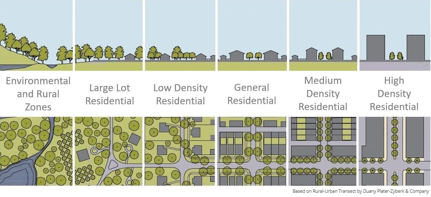
Figure 6: Proposed use of residential zones
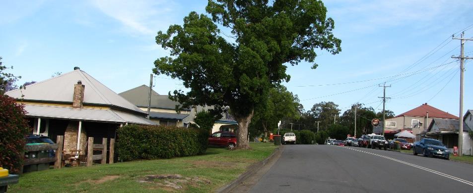
Low Density Residential Zone
The Low Density Residential zone will provide longer-term assurance or protection to established or future low-scale residential areas where issues such as heritage, character and impacts of higher densities are particularly important. This may include township locations where there is well established development patterns / historical or heritage characteristics that suit the retention of low scale housing. This could also be in coastal locations that are not specifically identified as areas for increased densities or that are not located in close proximity to services and facilities that are typically only available in business and commercial zones.
The vision for the zone is to create consistency with existing and emerging character, including in terms of subdivision patterns, dwelling density and other permitted uses. It will typically comprise of single dwellings with some additional density through secondary dwellings (e.g. a granny flat) or dual occupancy development (e.g. a duplex).
The planning controls associated with the zone would typically include:
Height limit 8.5m (except Gloucester and parts of Red Head)
Floor Space Ratio None - the scale of buildings would be controlled through character objectives, local character statements and development control plans (DCPs)
Minimum lot size 450sqm (except in parts of Bulahdelah that are subject to a 700sqm minimum lot size)
Examples of the type of development that would typically be expected in the zone are shown adjoining.
Single / two storey dwelling houses

Single / two storey dual occupancies

Typical Street view in the Low Density Zone
General Residential Zone
The General Residential zone will provide a more broad ranging and flexible approach to residential development than the Low Density Zone. As well as allowing the types of development that would be available in the Low Density zone, the General Residential zone would allow "multi dwelling housing", being three or more dwellings on a site. This zone would also allow other types of housing, such as terraces, manor housing and manufactured home estates. In some coastal locations (Hawks Nest, Tea Gardens, Forster) and Taree, additional height will be permitted (12m) to enable more people to live close to services and facilities.
The vision for the zone is to enable some density, but in a way that maintains a low-scale environment. It will provide for smaller dwellings / units that are popular for people down-sizing or entering the housing market. This zone will apply to undeveloped residential land to enable the flexibility to achieve a range of residential outcomes.
The planning controls associated with the zone would typically include:
Height limit 8.5m generally, with 7.5m retained in Gloucester. Some areas of 12m in areas such as Taree, Forster Hawks Nest and Tea Gardens
Floor Space Ratio None - scale of buildings controlled through character objectives, local character statements and development control plans (DCPs)
Minimum lot size 450sqm generally. 300sqm when houses are also approved with subdivision (integrated housing)
Examples of the type of development that would typically be expected in the zone are shown adjoining.
Multi dwelling housing - "villa" development

Low rise medium density interspersed with existing dwelling houses
Medium Density Residential Zone
The Medium Density Residential zone will be used to facilitate a more substantial increase in residential densities, typically in localities that currently, or are planned to have a range of services, employment and community facilities available nearby. Building height limits would typically be higher than the Low Density or General Residential zones, enabling "residential flat buildings" to be developed. The Medium Density zone would also restrict lower scale buildings, with single houses being prohibited as they would not result in the desired density being achieved (existing houses would not be impacted). The vision for the zone is to increase densities in areas that reinforce the viability of town centres, encourage walking and cycling and reduce dependence on private vehicles. This zone would also aim to create a greater diversity of housing types. This is needed in response to the changing market with an aging population and escalating housing costs meaning that smaller dwellings and greater densities are needed. This zone will also accommodate housing for tourists. The planning controls associated with the zone would typically include:
Height limit 12m, though higher in some limited locations such as Forster and Tuncurry
Floor Space Ratio None - scale of buildings controlled through character objectives, local character statements and development control plans (DCPs)
Minimum lot size 1,000sqm generally. 200sqm (but no more than 300sqm) when houses are also approved with subdivision (integrated housing)
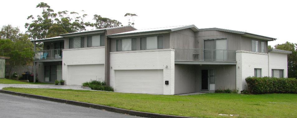
Examples of the type of development that would typically be expected within the zone is shown adjoining.
Low-rise medium density dwellings / small lot housing

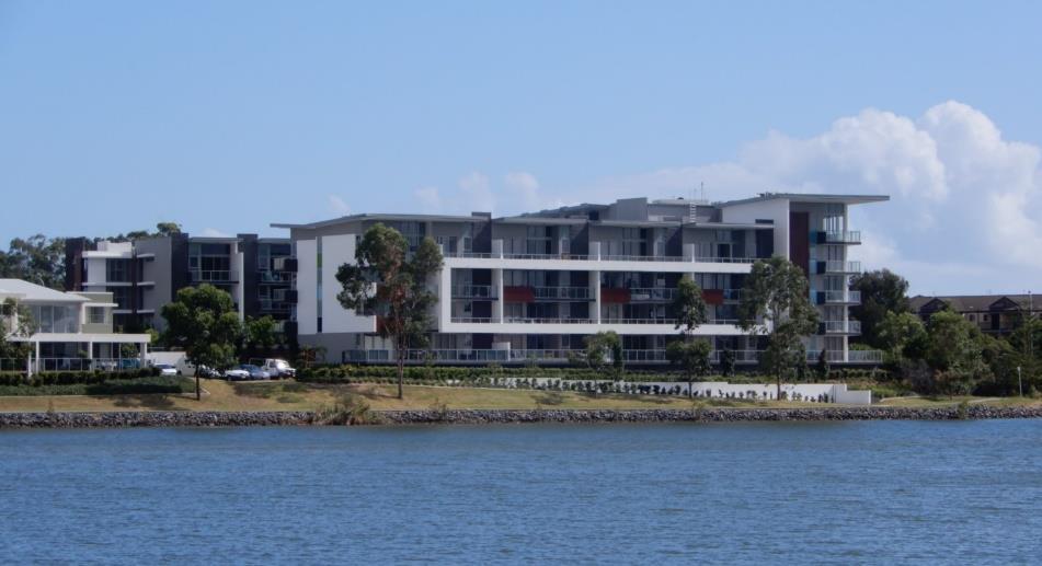
Residential flat buildings on waterfront with public access
High Density Residential Zone
The High Density Residential zone signifies a much greater level of development - particularly in terms of the height limits that would be permitted. This zone would be focused in the centre of major towns, including Forster and Tuncurry where this zone is already present.
Building height limits would typically be higher again than the Medium Density Residential zones, being up to 10 storeys or more. The zone specifically seeks greater levels of density, with larger scale developments being encouraged, albeit still enabling some lower scale medium density forms, typically only when land is not able to be amalgamated for higher density development.
The vision for the zone is to make core town centre areas busy and vibrant, where residents and visitors have easy access to nearby services and facilities. This zone would increase the number of unit style developments in highly desirable locations, with quality views and associated infrastructure such as waterfront open spaces.
The planning controls associated with the zone would typically include:
Height limit 18 - 33m
Floor Space Ratio None - scale of buildings controlled through character objectives, local character statements and development control plans (DCPs)
Minimum lot size 1,000sqm generally
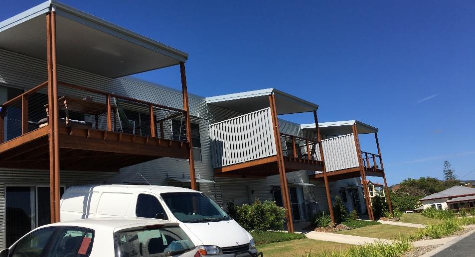
Examples of the type of development that would typically be expected in the zone are shown adjoining.
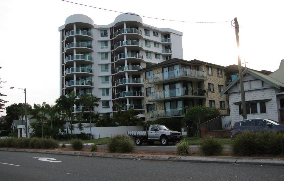
Range of high and medium scale development
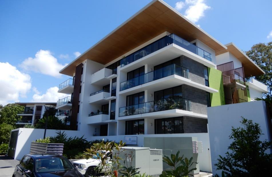
Residential flat buildings on smaller sites
Large Lot Residential Zone
The Large Lot Residential zone would be retained primarily as it already exists in the three current LEPs. This zone is often used on the periphery of urbanised areas or within a more discrete rural setting. It provides a balance between living in urbanised residential areas and rural or environmental zones. Dwellings in this zone would typically be one or two storeys, but are often larger homes than those that are able to be accommodated in existing towns and villages.
Subdivisions would require careful consideration of land use conflicts (particularly with agricultural uses), sensitive environments and access to services. Critical to the minimum lot size is availability of reticulated sewerage systems. Where sewer connections are available, the lot size can be smaller. Areas without this infrastructure must accommodate their sewerage waste "on-site" - traditionally via a septic system.
The vision for the zone is to provide opportunities to transition between urban and rural locations. Enabling larger lots will accommodate those seeking lifestyle choices that provide for space and separation without being in more isolated rural areas.
The planning controls associated with the zone would typically include:
Height limit 8.5m
Floor Space Ratio None - scale of buildings controlled through character objectives, local character statements and development control plans (DCPs)
Minimum lot size* 4,000sqm where reticulated sewerage system is available. 1.5Ha where not available.
*NOTE: This minimum lot size will apply to future development. Current minimum lot sizes will apply to existing sites where constraints and servicing determined the appropriate lot size. Examples of the type of development that would typically be expected within the zone is shown below.

Large lot area within environmental setting
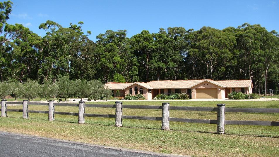
Typical larger footprint homes with open space surrounds
Village Zone
The Village zone is currently used in a relatively consistent way in each of the three existing LEPs. It is proposed to be retained in a similar form - being used in a number of typically smaller coastal and rural towns and villages. The Village zone allows for a wide range of land uses, including residential, business, industrial and various other commercial and community activities. In a more compact urban environment this can result in some frequent land use conflicts, but on a smaller scale, and in a more open or rural setting. This zone enables for a range of services to be provided to their communities in a more flexible way. Development would be low scale (two storey), with the lot size depending on access to appropriate reticulated sewerage systems. The vision for the zone is to retain flexibility in the evolution and development of smaller villages, enabling them to respond to their own specific needs, whilst maintaining the character of the area. The planning controls associated with the zone would typically include:
Height limit 8.5m
Floor Space Ratio None - scale of buildings controlled through character objectives, local character statements and development control plans (DCPs)
Minimum lot size* 1,000sqm where reticulated sewerage system is available. 1.5ha where not available
*NOTE: This minimum lot size will apply to future development. Current minimum lot sizes will apply to existing sites where constraints and servicing determined the appropriate lot size
Examples of the type of development that would typically be expected within the zone is shown adjoining.
Mix of residential and commercial uses

Character dwellings and typically wide roads


