
March 2025

March 2025
Date March 2025
Title Capitol Heights Vacant Lot Strategy
Author The Maryland-National Capital Park and Planning Commission
Subject Capitol Heights Vacant Lot Strategy
Source of copies The Maryland-National Capital Park and Planning Commission 1616 McCormick Drive
Largo, MD 20774
Series number 449242306
Number of pages 78
This document is a Vacant Lot Strategy for the Town of Capitol Heights, a small municipality located in Prince George’s County, Maryland, incorporated in 1910 (Planning Area 75B, Councilmanic District 7). In fall 2021, the Town applied to the Prince George’s County Planning Department’s Planning Assistance to Municipalities and Communities (PAMC) program to fund this strategy. PAMC funding was approved by the Prince George’s County Planning Board on May 26, 2022, and the project kicked off January 13, 2023.The strategy establishes a Vacant Lot Inventory; identifies existing regulatory, environmental, maintenance and financial challenges; and provides goals and recommendations for maintaining, repurposing, and/or developing vacant lots. The Capitol Heights Vacant Lot Strategy aligns with past and ongoing planning efforts by the Town, the County, and the greater Washington, DC region to support livable and transit-oriented communities.
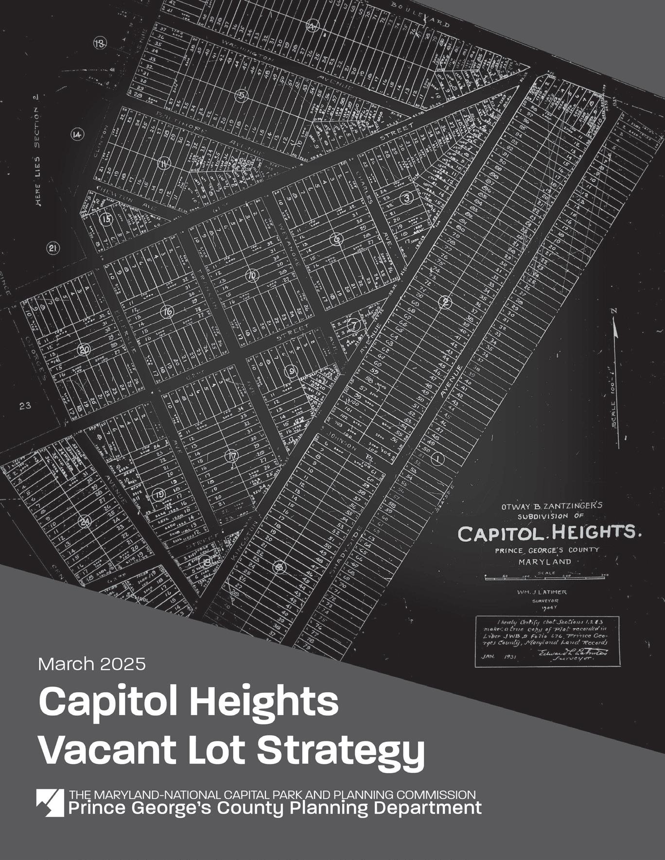
COVER Plot map of Capital Heights, ca. January 1931. Prince George’s County Circuit Court Plat Book LIB A, p.74. CREDIT: M-NCPPC, pgatlas.com, Accessed October 3, 2024
Artie L. Harris, Jr., Chair
Peter A. Shapiro, Vice Chair
Officers
William Spencer, Acting Executive Director
Gavin Cohen, Secretary-Treasurer
Debra Borden, General Counsel
The Maryland-National Capital Park and Planning Commission (M-NCPPC) is a bicounty agency, created by the General Assembly of Maryland in 1927. The Commission’s geographic authority extends to the great majority of Montgomery and Prince George’s Counties: the MarylandWashington Regional District (M-NCPPC planning jurisdiction) comprises 1,001 square miles, while the Metropolitan District (parks) comprises 919 square miles, in the two counties.
The Commission has three major functions:
• The preparation, adoption, and, from time to time, amendment or extension of the General Plan for the physical development of the MarylandWashington Regional District.
• The acquisition, development, operation, and maintenance of a public park system.
• In Prince George’s County only, the operation of the entire county public recreation program.
The Commission operates in each county through a Planning Board appointed by and responsible to the County government. All local plans, recommendations on zoning amendments, administration of subdivision regulations, and general administration of parks are responsibilities of the Planning Boards.
The Prince George’s County Planning Department:
• Our mission is to help preserve, protect and manage the County’s resources by providing the highest quality planning services and growth management guidance and by facilitating effective intergovernmental and citizen involvement through education and technical assistance.
• Our vision is to be a model planning department of responsive and respected staff who provide superior planning and technical services and work cooperatively with decision makers, citizens, and other agencies to continuously improve development quality and the environment and act as a catalyst for positive change.


County
Tara H. Jackson, Acting County Executive
Council
The County Council has three main responsibilities in the planning process: (1) setting policy, (2) plan approval, and (3) plan implementation. Applicable policies are incorporated into area plans, functional plans, and the general plan. The Council, after holding a hearing on the plan adopted by the Planning Board, may approve the plan as adopted, approve the plan with amendments based on the public record, or disapprove the plan and return it to the Planning Board for revision. Implementation is primarily through adoption of the annual Capital Improvement Program, the annual Budget, the water and sewer plan, and adoption of zoning map amendments.
Council Members
Edward P. Burroughs III, Chair, 8th District
Krystal Oriadha, Vice Chair, 7th District
Thomas E. Dernoga, 1st District
Wanika B. Fisher, 2nd District
Eric C. Olson, 3rd District
Ingrid S. Watson, 4th District
Vacant, 5th District
Wala Blegay, 6th District
Sydney J. Harrison, 9th District
Calvin S. Hawkins, II, At-large
Jolene Ivey, Chair, At-large
Clerk of the Council: Donna J. Brown
Table
Figure
Figure
Figure
Figure
Figure
Figure
Figure
Figure
Figure

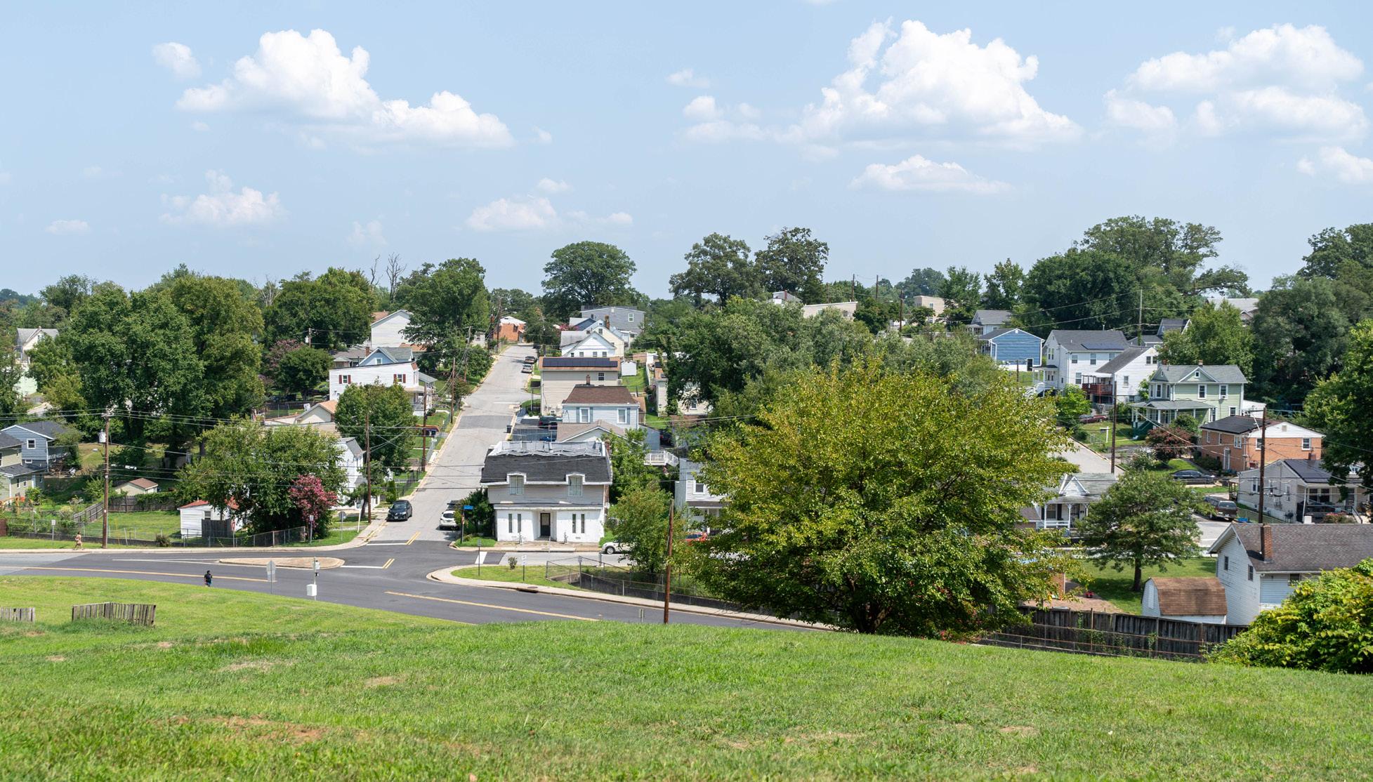
Capitol Heights was established in 1904 as a residential suburb by Otway B. Zantzinger, a Baltimore-based businessman. The subdivision included approximately 4,000 lots on what was originally a large parcel of woodland. The majority of lots in Capitol Heights were long, narrow, rectangular parcels, approximately 20 feet wide and 100 feet deep. The growing community incorporated as the Town of Capitol Heights in 1910 in an effort to improve roads and public services for residents. In November 1980, the Washington Metro line opened the Capitol Heights Metro Station at the northernmost tip of the original Capitol Heights subdivision (133 Central Avenue).1
The Town is adjacent to the southeastern boundary of Washington, DC and is located along Metro’s Blue Line corridor. The lands surrounding the Metro Station and the central section of the Town have singlefamily residential uses with churches scattered throughout and businesses located along MD 332 (Old Central Avenue). The southern section of the Town is industrial in character. In 2020, the Town had approximately 4,000 residents in approximately 1,600 housing units. 2
Today, approximately 10 percent of the total lots within the Town of Capitol Heights are vacant. In fall 2021, the Town applied to the Prince George’s County Planning Department’s Planning Assistance to Municipalities and Communities (PAMC) program to fund a Vacant Lot Strategy. PAMC funding was approved by the
Prince George’s County Planning Board on May 26, 2022, and the project kicked off on January 13, 2023.
The PAMC program is offered by The Maryland-National Capital Park and Planning Commission (M-NCPPC), Prince George’s County Planning Department, Community Planning Division, Neighborhood Revitalization Section. The program’s purpose is to assist in protecting and implementing the County’s approved plans, recommendations made in Planning Department studies, and strategies and action items in approved Maryland Sustainable Communities action plans. The program provides technical planning services at no cost to municipalities or community organizations using Prince George’s County Planning Department expertise, and/or funds consultant services approved by the Planning Board. PAMC projects benefit municipalities and communities that may have limited planning resources but are committed to revitalization and enhancement of their communities.
The Capitol Heights Vacant Lot Strategy aligns with past and ongoing planning efforts by the Town, the County, and the greater Washington, DC region to support livable and transit-oriented communities. The Washington, DC region faces a demand for more housing, including that which is “affordable,” “missing middle,” and other diverse types accessible to transit. This publication works to implement recommendations in the 2017
1 “Capitol Heights and Greater Capitol Heights (75A-056),” Historic Communities Survey, EHT Traceries, Inc., 2009. Accessed April 11, 2024, Historic Sites and Districts Plan Historic Resource and Community Survey Update Database (mncppcapps.org).
2 “Capitol Heights Town, Maryland,” United States Census Bureau, accessed December 11, 2023, https://data.census.gov/ profile/Capitol_Heights_Town,_Maryland?g=160XX00US2413000
“Central Avenue-Metro Blue Line Corridor Sustainable Community Action Plan,” specifically, its guidance to “preserve and expand the range of housing types and ownership opportunities” and “promote mixed-use, transit-oriented development and neighborhood revitalization in the Sustainable Community Area.” Subsequent action plan strategies encourage appropriate infill housing development and the revitalization of older neighborhoods.
This Vacant Lot Strategy builds on observations, recommendations, and polices and strategies in Plan 2035 steep and active community plans: the 2008 Approved Capitol Heights Transit District Development Plan and the 2010 Approved Subregion 4 Master Plan
Plan 2035’s Housing and Neighborhoods Policy 3, “Stabilize existing communities and encourage revitalization and rehabilitation,” contains Strategy HN3.2, “Biannually inventory foreclosed and neglected properties to ensure effective monitoring and mitigation of housing blight…” (p. 188). Strategy HN3.4 states, “Enforce housing maintenance standards and building codes. Particular attention should be directed towards Neighborhood Reinvestment areas and established communities,” (p. 188). Community Character Principle 7, “Promote thoughtful design in Local Centers and Regional Transit Districts” includes the recommendation that, “Where there is a sufficient mix of uses, centers should focus on renovating and adapting vacant or underutilized buildings and/or
on promoting infill development on vacant lots,” (p. 207). (A portion of the Town of Capitol Heights is located in the Plan 2035 Capitol heights Metro Local Transit Center.) Strategy HD11.2 states, “Promote the use of the Planning Assistance to Municipalities and Communities Program as a tool to complete small-scale urban design analyses to address urban design challenges and opportunities,” (p. 216).
The 2010 Approved Subregion 4 Master Plan states, “Another opportunity includes attracting new retailers into Subregion 4 to increase the variety and quality of goods being offered locally. The best opportunity is to increase the spending potential within the subregion. One method of obtaining this goal is to create more high-quality, owneroccupied residential options on vacant and infill parcels,” (p. 43).
The 2008 Approved Capitol Heights Transit District Development Plan acknowledges that, “Limited commercial development is concentrated along Old Central Avenue, Capitol Height’s historic “main street. Many of these uses are vacant or underutilized, and some of them are visually unattractive or incompatible with adjacent residential uses,” (p. 5).
The Vacant Lot Strategy will also inform and support the Central Avenue-Blue/Silver Line Sector Plan and Sectional Map Amendment (underway as of this writing) and which includes portions of the Town of Capitol Heights.
The Town currently has 194 vacant properties, about which the following is observed:
• The gateways to the Town near the Capitol Heights Metro Station and along the Town’s border with Washington, DC contain a concentration of vacant lots.
• Approximately one-third of the Town was platted prior to the establishment of the County Zoning Ordinance and many lots are nonconforming.
• Some vacant lots represent ongoing maintenance and enforcement challenges. Overgrown and invasive vegetation and the buildup of litter and debris are unattractive nuisances.
• Some vacant lot owners do not have the means, ability, or interest in maintaining their lots.
• Vacant lots reduce Town tax revenue and increase Town costs.
• Undeterminable lot boundaries, especially for multiple contiguous vacant lots with different owners, create enforcement and administrative challenges.
• Steep slopes or wetlands were identified on some vacant lots.
• To address these issues and outline a more economically resilient future for the Town, the Capitol Heights Vacant Lot Strategy:
» Establishes a Vacant Lot Inventory;
» Identifies existing regulatory, environmental, maintenance, and financial challenges;
» Provides goals and recommendations for maintaining, repurposing, or developing vacant lots;
» Identifies relevant stakeholders and timing to implement the recommendations; and
» Prioritizes the recommendations and identifies short term action items.
A detailed analysis of the Town’s vacant lots and their challenges is provided in the Existing Conditions section of this report. An index of the vacant lots is provided in the Appendix.
August
February
August
The Vacant Lot Strategy began in early 2023 and included a site visit with the Town Council and staff, a technical metrics analysis of the vacant lots, brainstorming sessions focusing on recommendations, and conversations with Town staff. Figure 2 presents additional details regarding the project process.

Town Staff lead Town Council and Project Team on tour of vacant lots
Project Team analyzes vacant lots based on site visit observations and a series of metrics related to ownership, property characteristics, and natural resources
Project Team develops and shares draft recommendations with Town; Town and Project Team refine recommendations
Town and County work together to implement the Vacant Lot Strategy goals and recommendations
2 Project Process Overview
Project Team creates comprehensive vacant lot inventory based on two lists, one from the County and one from the Town, of vacant lots
Project Team reviews analysis findings and establishes goals to address vacant lot challenges
Project Team presents Vacant Lot Strategy final report to the Town
Neither APA (the American Planning Association) nor ULI (the Urban Land Institute) nor the Zoning Ordinance provide a definition for the term “vacant lot.” For the purposes of this project, a vacant lot is a lot that does not have a primary structure and does not contain the following:
• Parks or common areas;
• Yards of adjacent residential lots with the same owner;
• Paved driveways for adjacent lots with a building that has the same owner;
• Access road for an adjacent lot with the same owner;
• Private rights-of-way and parking lots built for parking (as opposed to ad-hoc parking lots);
• Industrial sites (for example, outdoor industrial storage); or
• Fenced maintenance yards.
These are the criteria that were used to develop the Vacant Lot Inventory.
As of the date of the publishing of this strategy, there is no master list of vacant lots in the County and there is no uniform definition of a “vacant lot.”
The consultants and M-NCPPC Planning Department staff reviewed two vacant lot lists, one compiled by Town staff and one created by M-NCPPC’s Prince George’s County Planning Department’s Geographic Information Systems (GIS) staff for the Vacant Lot Strategy. The Town’s list of 181 lots was based on field observations and tax data. The Town considers a lot to be
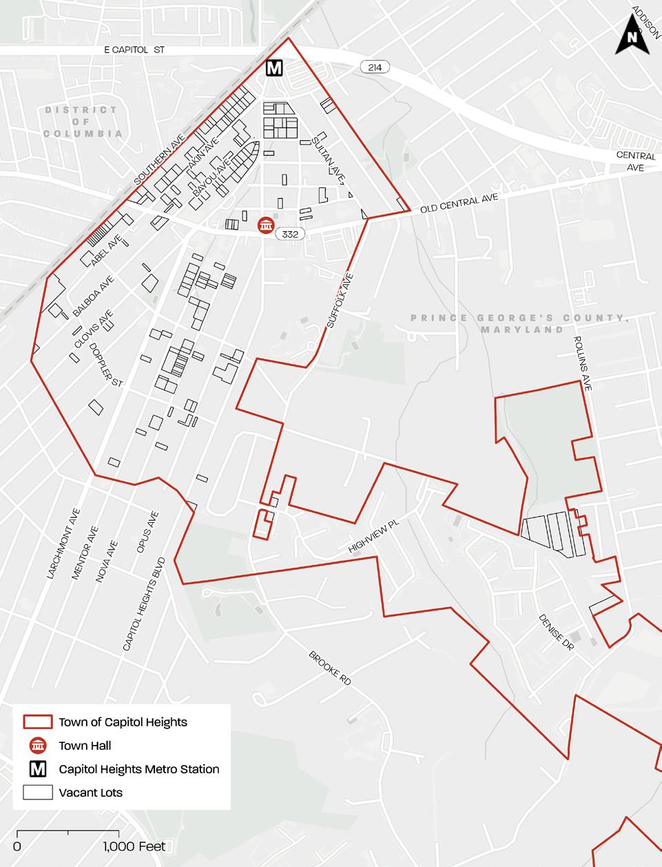
Map 1 . Vacant Lot Inventory
Source: PGAtlas . com
vacant if 1) the lot does not have a building or other improvement that has an assessed value as determined by the Maryland State Department of Assessments and Taxation (SDAT) and 2) the lot is not:
• Zoned for residential use and the owner occupies a residence on an adjacent lot;
• Contiguous to a lot with an occupied building and both lots have the same owner; or
• Utilized as a parking lot in compliance with the Zoning Ordinance and other applicable ordinances.
M-NCPPC’s list of 204 lots was extracted
from SDAT GIS data. The Maryland Department of Assessments and Taxation (SDAT) considers a lot to be vacant if it has a tax value of less than $15,000. SDAT is tax account-based, not lot-based. One tax account may reference multiple lots, parts of adjacent lots, or a combination thereof. One lot can have multiple accounts, but only one account might contain improvements information. The lot layers in PGAtlas.com use LiDAR (Light Detection and Range) and building footprint data to spatially verify that there is not a structure greater than 400 square feet on a lot.
However, older lot lines do not necessarily follow the legal descriptions of accounts, and the lot lines themselves are not always accurate, so the alignment of building footprints on older lots is imperfect.
To develop the Vacant Lot Inventory, the project team reviewed SDAT GIS data and photography from Esri and Google Street View to confirm that the lots in the Town’s list and M-NCPPC’s list met the vacant lot criteria. As the project progressed, additional lots were added that were not originally included in the County or Town’s lists but met the vacant lot criteria. The final inventory consists of 194 lots (see Map 1).3
The following section highlights existing conditions and considerations for vacant lots based on conversations with Town staff, observations from the site visit, and an analysis of vacant lots using mapping software.
3 Of the 194 lots in the Vacant Lot Inventory, 3 are partially vacant and partially not vacant. These lots have more than one owner/tax account number and are composed of more than one lot. The lot(s) associated with one of these owners/tax account numbers is vacant. The lot(s) associated with the other owner/tax account number is not vacant. The three partially vacant and partially not vacant lots are located north of MD 332 (Old Central Avenue) on the southeastern side of Bayou Avenue (Tax Accounts 2022010 and 2050334), on the northwestern side of Akin Avenue (Tax Accounts 2032308 and 2060101), and between Akin Avenue and Bayou Avenue (Tax Accounts 1994078 and 2073898). For the purposes of this project, the boundaries of the three partially vacant and partially not vacant lots are shown on all maps in this report, although part of the lot is not actually vacant. The focus of the Capitol Heights Vacant Lot Strategy is on the Town’s residential neighborhoods and commercial corridors. Therefore, vacant lots in the southern industrial area of the Town were excluded from the inventory.
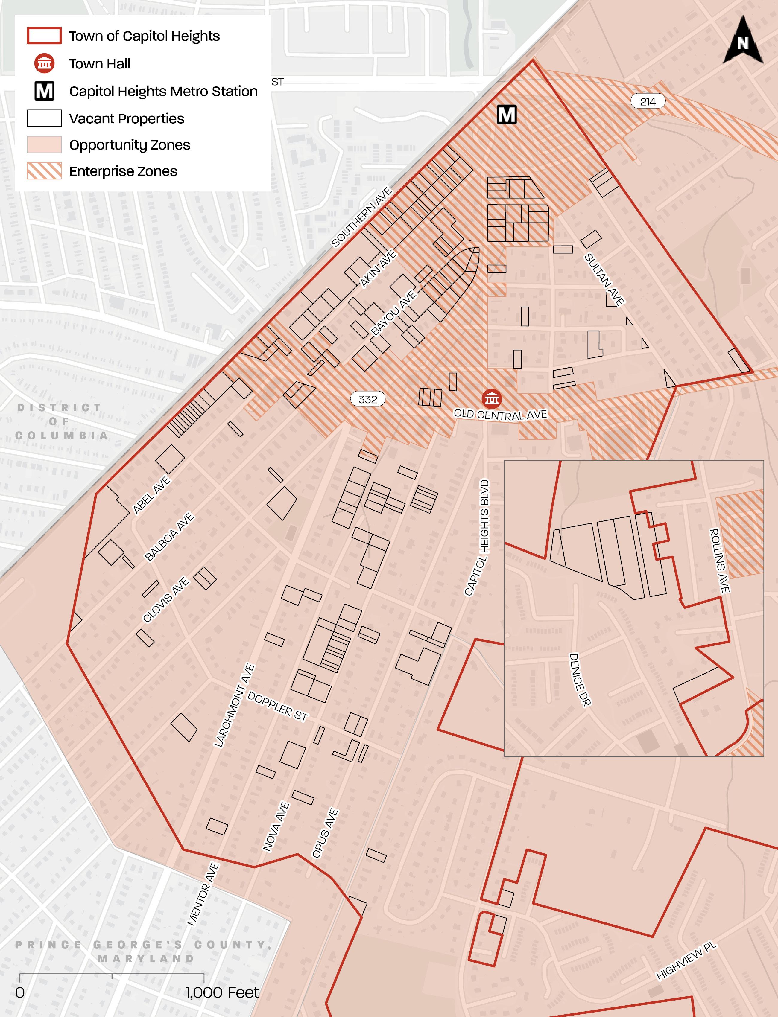
Approximately 66 percent of vacant lots (or 129 lots) are privately owned; approximately 23 percent (or 45 lots) are Town-owned; approximately 10 percent (or 19 lots) are County-owned, and approximately 1 percent (or 1 lot) are County/Town-owned (see Map 3). Town-owned vacant lots are found predominantly in the northern area, while County-owned vacant lots are dispersed throughout the Town.
Certain streets contain multiple contiguous vacant lots, some with the same owner and some with different owners. Map 4 depicts each owner by color. In areas with contiguous vacant lots with different owners, Town staff have found it difficult to identify the boundaries of individual lots and their respective owners. When Town staff are unable to discern property boundaries, they face challenges with maintenance enforcement and issuing property violations and fines.
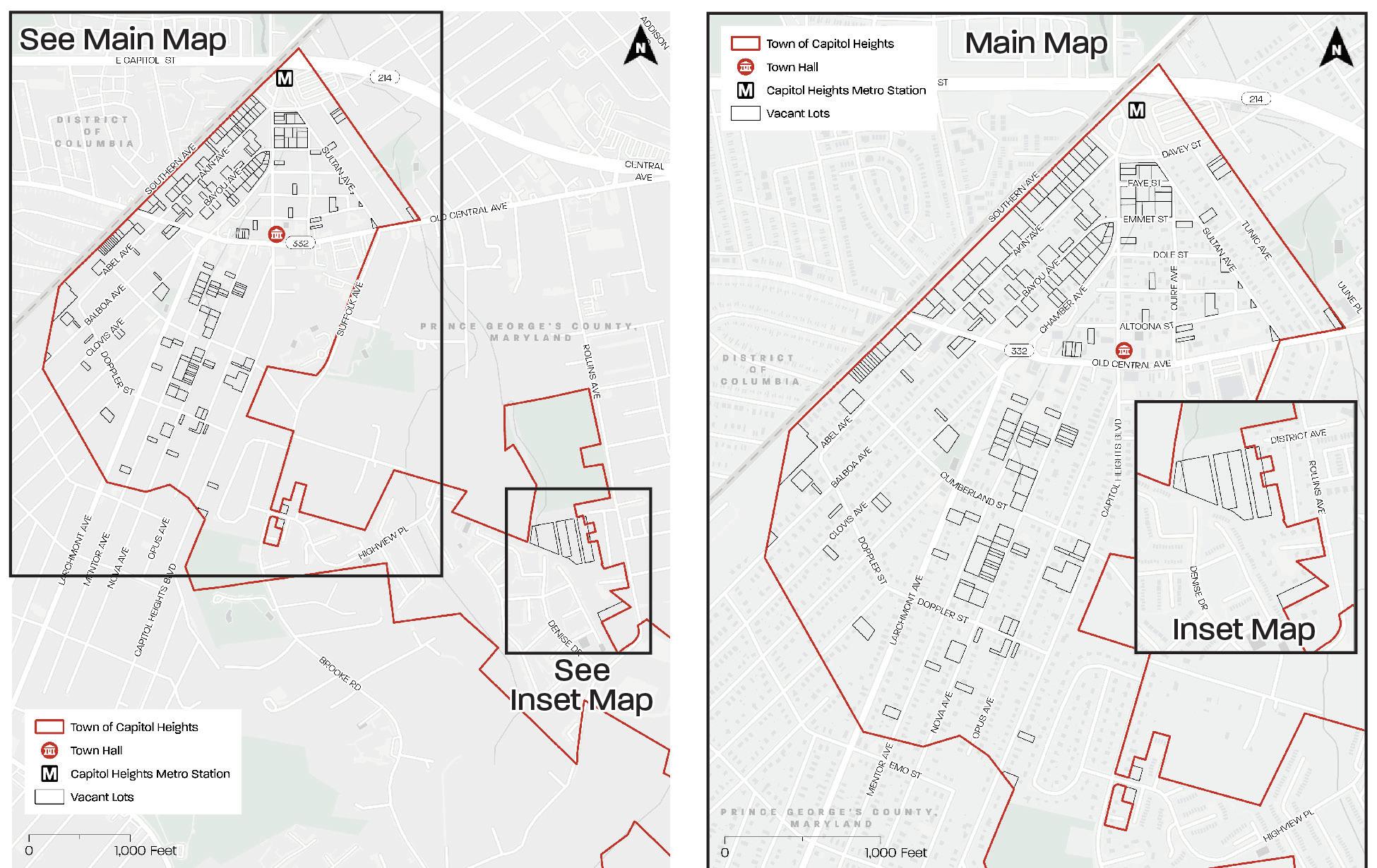
Map 2 . Map Extents
Source: PGAtlas com
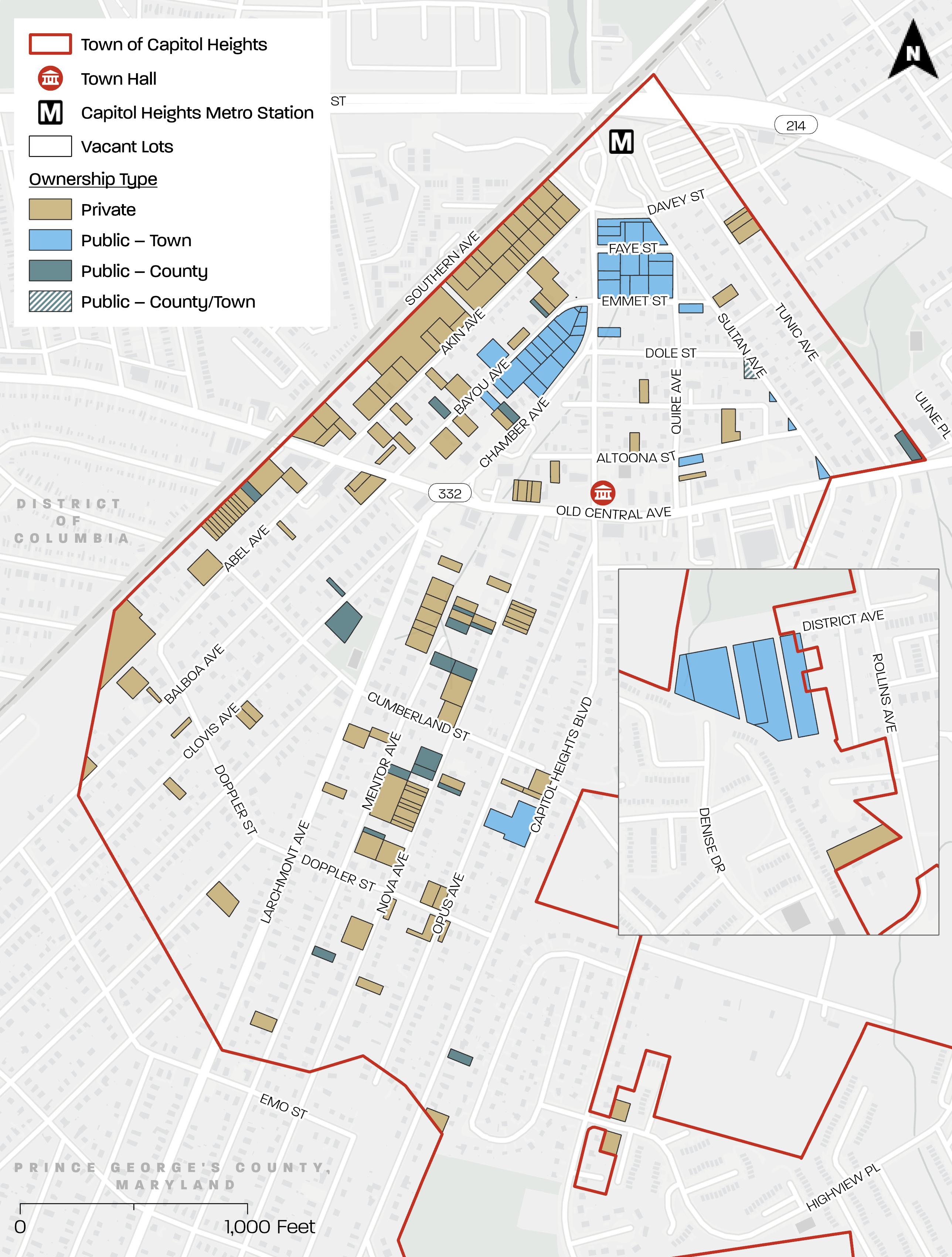
Map 3 Vacant Lots by Ownership Type
Source: PGAtlas . com and https://sdat . dat maryland gov/RealProperty/Pages/default aspx
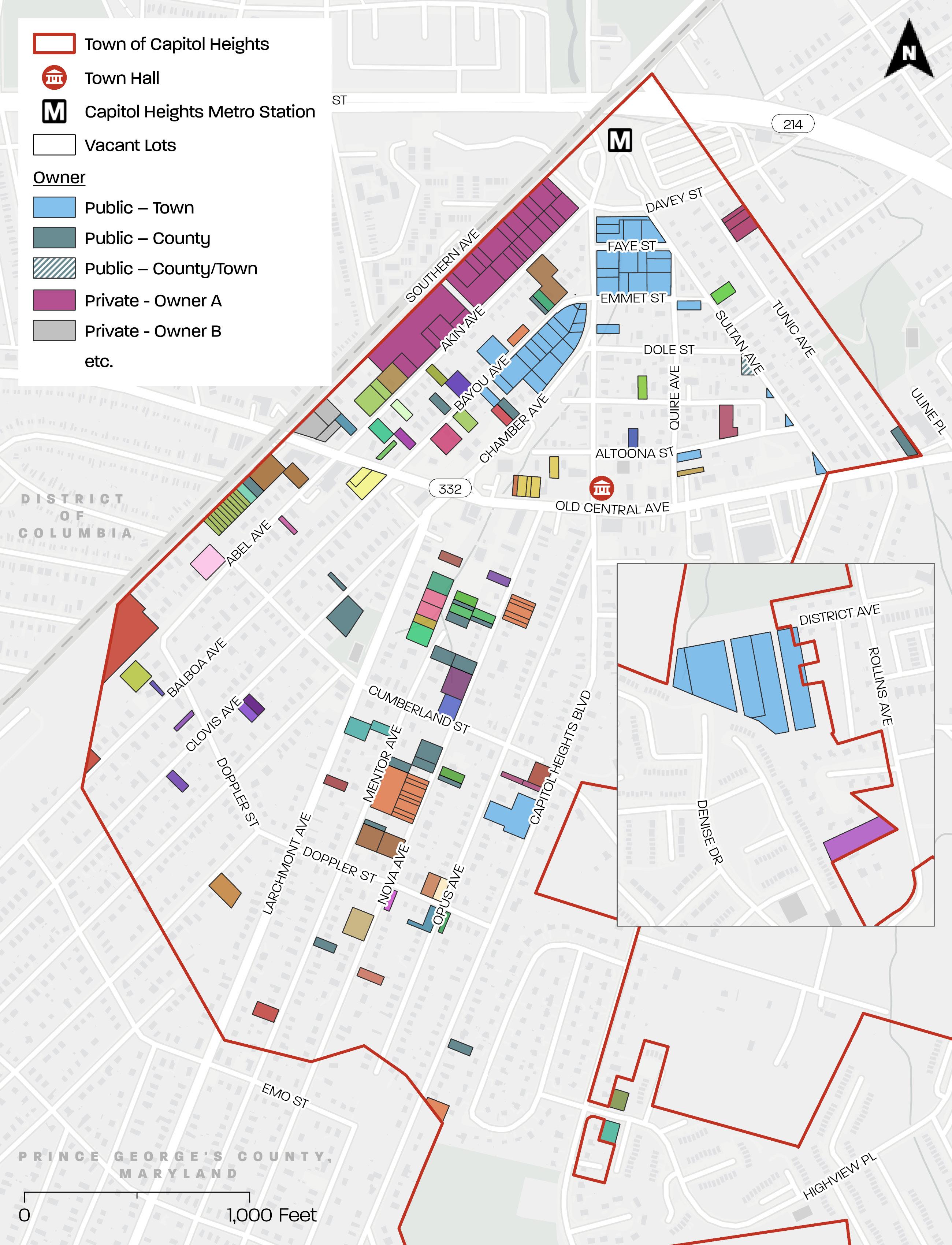
Map 4 . Vacant Lots by Owner
Source: PGAtlas . com and https://sdat . dat . maryland gov/RealProperty/Pages/default . aspx
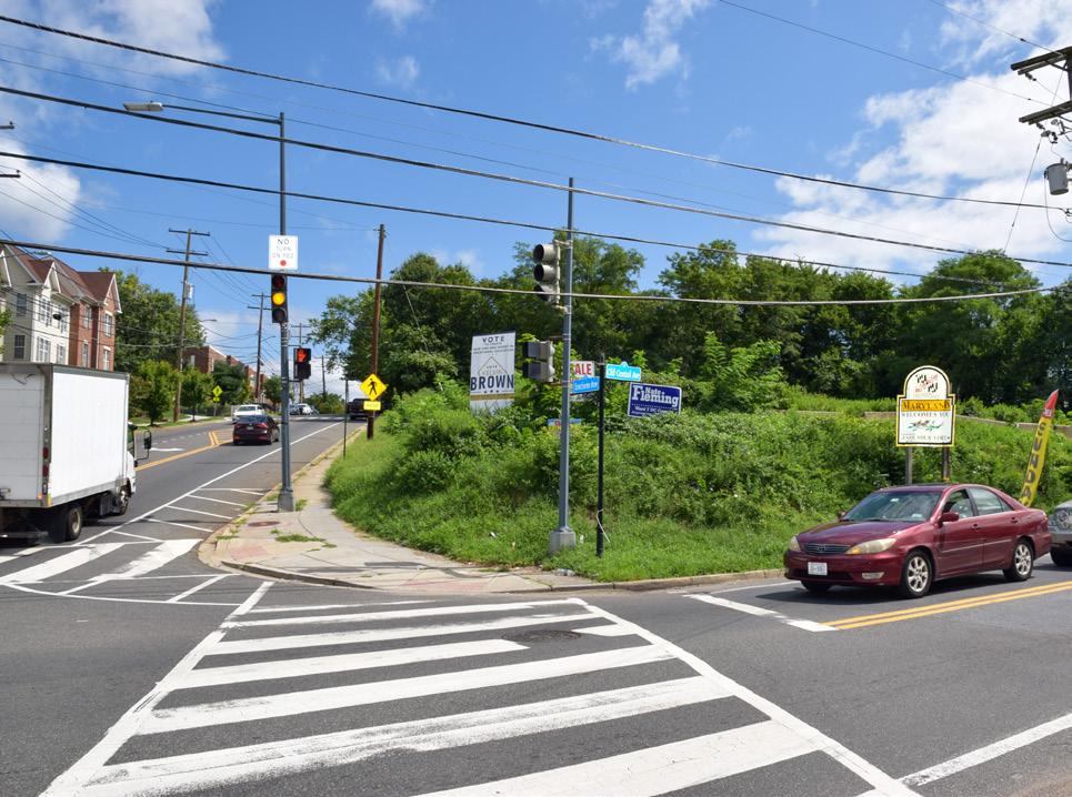
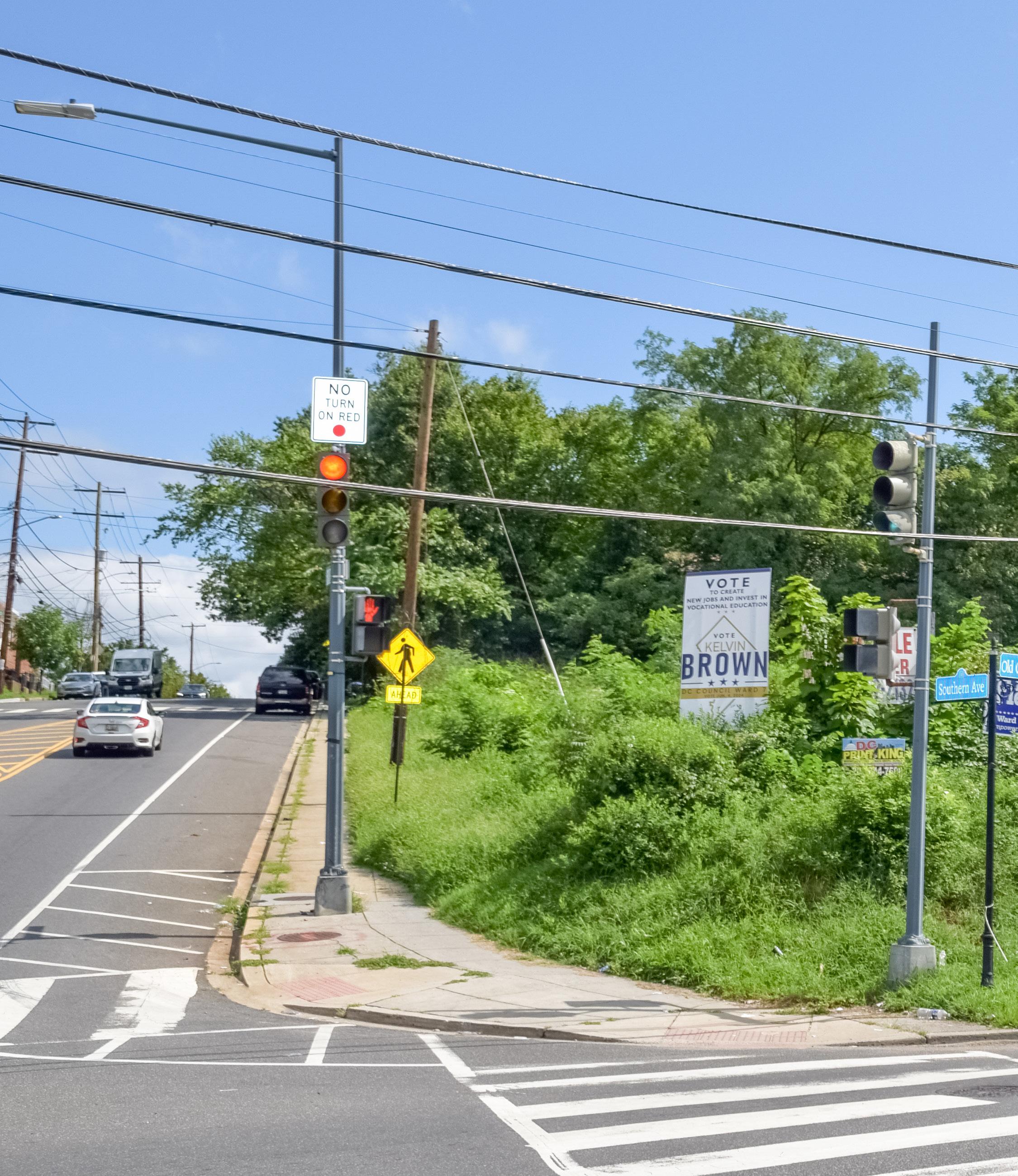
Approximately 43 percent of vacant lots (83 lots) are located in gateway areas of the Town (see Map 5). These are the first blocks experienced coming from the Capitol Heights Metro Station, traveling along Southern Avenue, or traveling along MD 332 (Old Central Avenue). More than half
(approximately 58 percent) of these lots (or 48 lots) are privately owned. Figure 3 and Figure 4 depict examples of gateway vacant lots near the Metro Station and along Southern Avenue. Many of the highly visible vacant lots should be considered for beautification or transit-oriented development (TOD) where zoned LTO-C or LTO-E (Local Transit-Oriented - Core/Edge).4
4 This includes most of the gateway vacant lots except those along Southern Avenue south of MD 332.
CREDIT: M-NCPPC
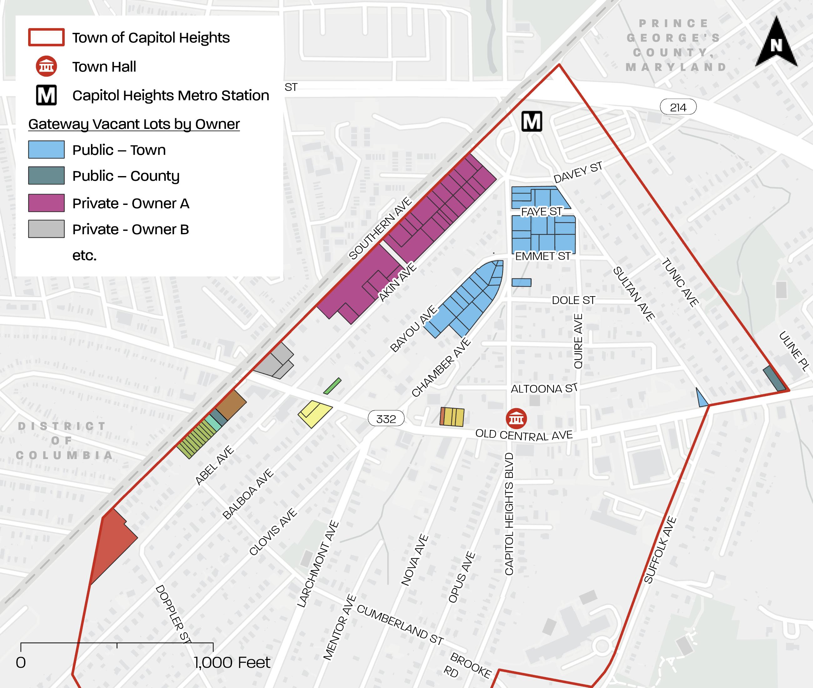
Map 5 . Gateway Vacant Lots by Owner
Source: PGAtlas . com and https://sdat dat . maryland . gov/RealProperty/Pages/default . aspx
More than half (approximately 53 percent) of vacant lots (or 103 lots) are zoned RSF65 (Residential, Single-Family - 65) (see Map 6). The purposes of the RSF-65 Zone are to provide for and encourage variation in the size, shape, and width of single-family detached residential subdivision lots, in order to better utilize the natural terrain; facilitate the planning of higher density single-family residential developments with small lots and dwellings of various sizes and styles; encourage the preservation of trees and open spaces; and prevent soil erosion and stream valley flooding.
Approximately 20 percent of vacant lots (or 38 lots) are zoned LTO-E (Local TransitOriented - Edge). Approximately 19 percent of vacant lots (or 36 lots) are zoned LTO-C (Local Transit-Oriented - Core). The purposes of the LTO Zone are to provide lands for moderate-intensity, vibrant, and transit-rich mixed-use centers; incorporate walkable and bikeable areas that are well-connected to a regional transportation network through a range of transit options; provide a mix of uses that serve community-wide needs; and encourage development that is well integrated in terms of complementary uses, access and circulation and compatible design. The LTO-C Zone focuses on mixeduse development, whereas the LTO-E Zone is less intense, with more emphasis on a residential mix and lower emphasis on commercial development. The principal structure height maximum for the LTO-C Zone is 80 feet and for the LTO-E Zone, 70 feet.
Approximately 10 percent of vacant lots (or 19 lots) are zoned RSF-A (Residential SingleFamily-Attached). The purposes of the RSF-A Zone are to provide for development in a form that supports residential living and walkability, is pedestrian oriented and is well connected to surrounding lands; provide development that is respectful of the natural features
of the land; and provide development that is compatible with surrounding lands. The RSF-A Zone allows single-family detached, two family, and three family dwellings; Townhouses; and “other uses.”5
Because the majority of the vacant lots are zoned for single-family residential uses, these lots should be considered for that type of residential infill, or where appropriate, uses such as side yards or pocket parks. The Central Avenue-Blue/Silver Line Sectional Map Amendment currently underway will likely upzone lots zoned RSF-65 and RSF-A close to the Capitol Heights Metro Station to encourage principles associated with TOD such as increasing residential development and commercial opportunities in proximity to the Capitol Heights Metro Station.
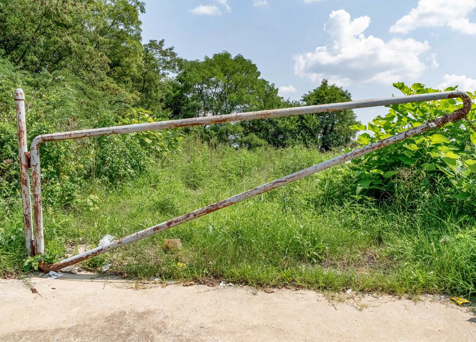
Figure 4 . Litter at a gateway location along Southern Avenue August 2024
CREDIT: M-NCPPC
According to the Zoning Ordinance (Subtitle 27 of the County Code) a “nonconforming lot” is a record lot that was legally created before the Ordinance, or an amendment thereto, was adopted, that is rendered noncompliant with the dimensional standards in this Ordinance. The current Zoning Code allows for the development of nonconforming
5 The sum of percentages is greater than 100 percent because two lots are split between two zones. The lot located on the southeast side of Bayou Avenue between MD 332 (Old Central Avenue) and Capitol Heights Boulevard (Tax Account 2022010) is split between the LTO-E and RSF-A Zones; the other lot located between Larchmont Avenue and Nova Avenue south of MD 332 (Old Central Avenue) (Tax Account 2065209) is split between the LTO-E and RSF-65 Zones.
lots under current standards without additional plan review processing until April 1, 2025. After that date, further review is required for non-conforming lots smaller than 6,500 square feet in applicable Zoning districts, including potentially initiating updates to the Zoning Code.
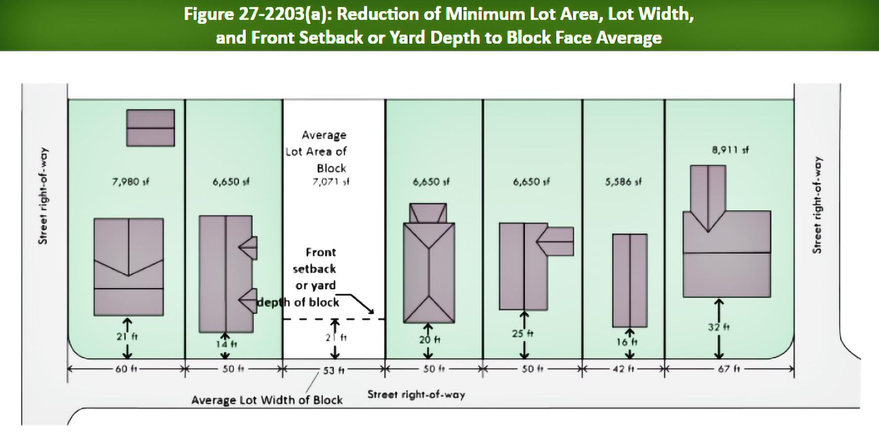
Approximately 40 percent of vacant lots (or 77 lots) do not meet the minimum lot area for the zone in which they are located (see Map 7).6 Most of these lots are privately owned and are located within the RSF-65 Zone. These lots range in size from approximately 475 square feet to approximately 6,300 square feet (the minimum lot area for the RSF-65 Zone is 6,500 square feet).
In the LTO-C and LTO-E Zones, a variance may be required depending on the nonconforming lot’s dimensions and the proposed use. Development of new dwellings on vacant lots that are lesser in
area than the residential zone requirements may proceed legally using an average lot area method. Specifically, where the average net lot area and/or width on a block of existing lots is less than the minimum applicable zone, the average net lot area and/or width becomes the minimum net lot area and/or width. Any lot equal to or greater than the average net lot area and width on the applicable block is then conforming. For lots that are developed using the averaging method, compliance with Section 22-22-2 (Exceptions) is required.
6
Similar to other communities throughout the Washington D.C. area, the presence of natural resources on a vacant lot would require additional site evaluation and compliance with applicable codes and regulations for future development purposes.
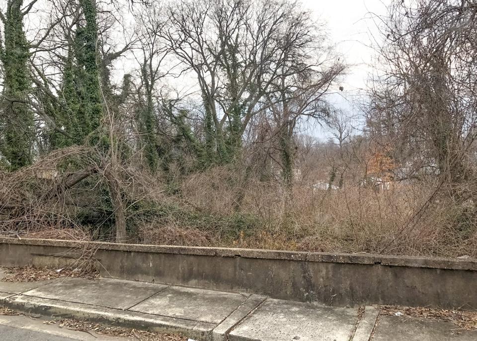
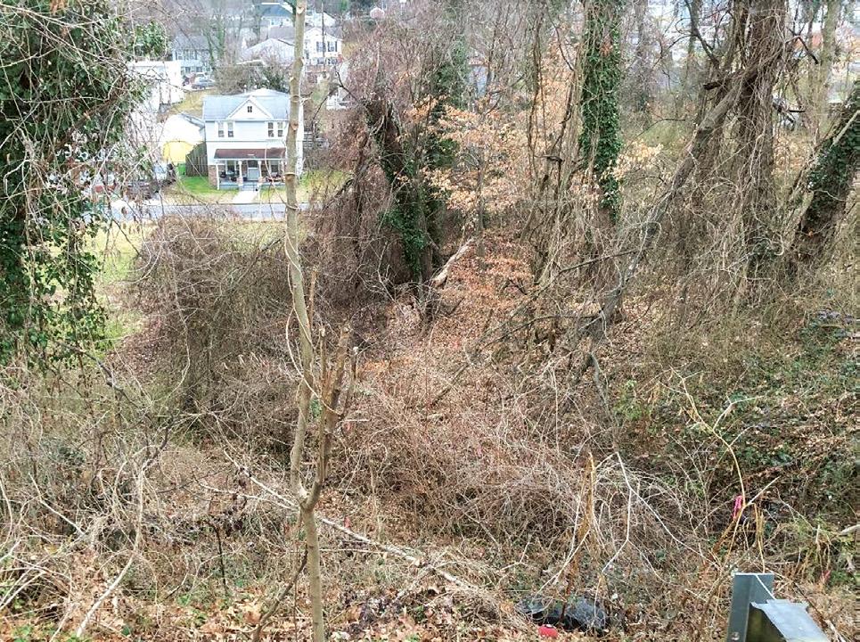
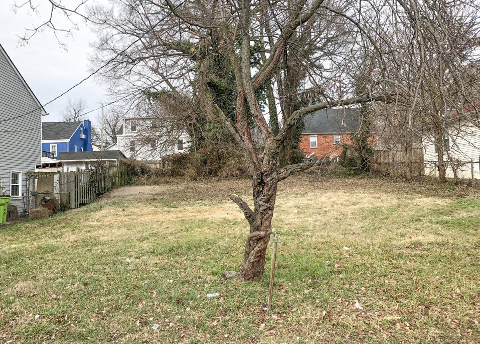
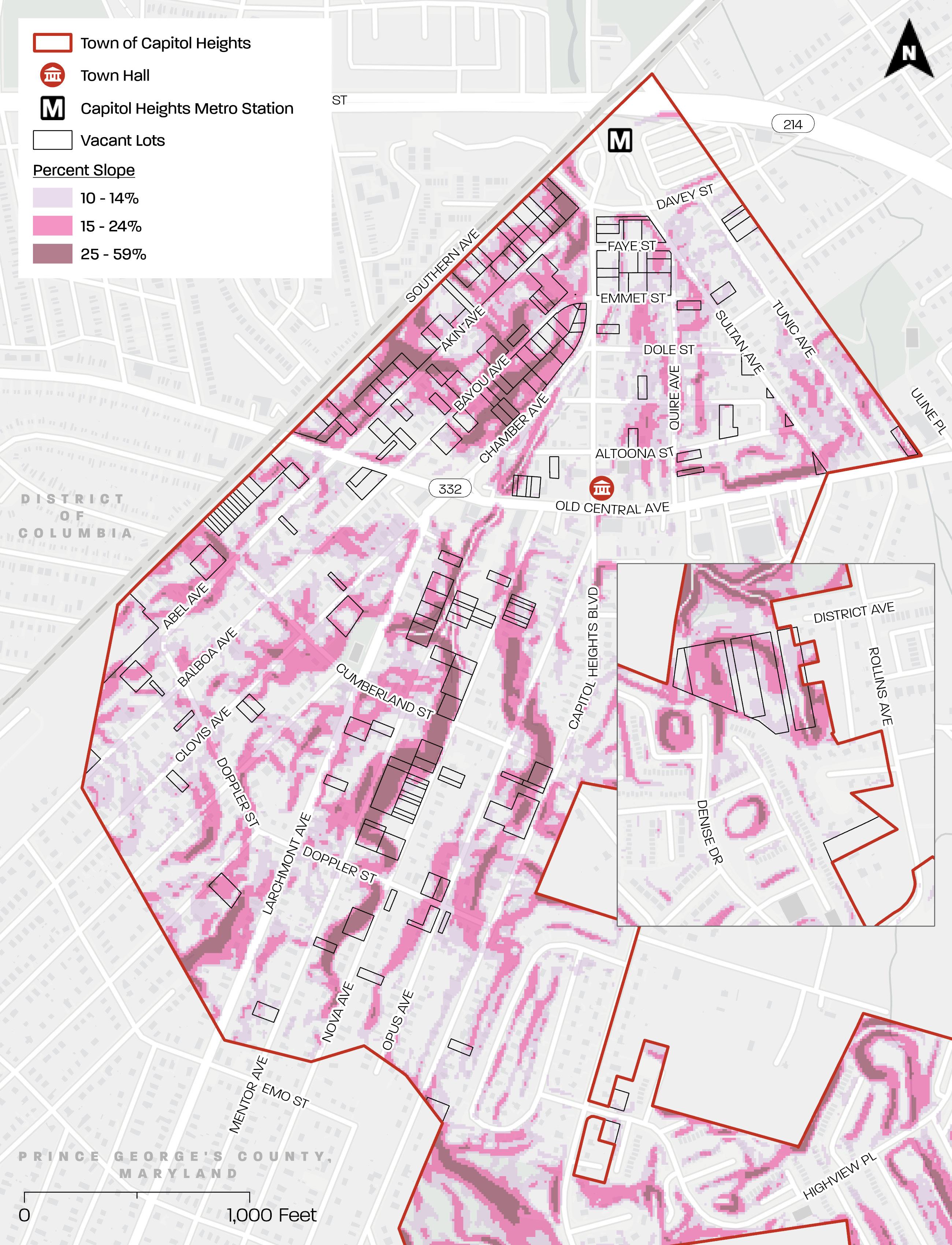
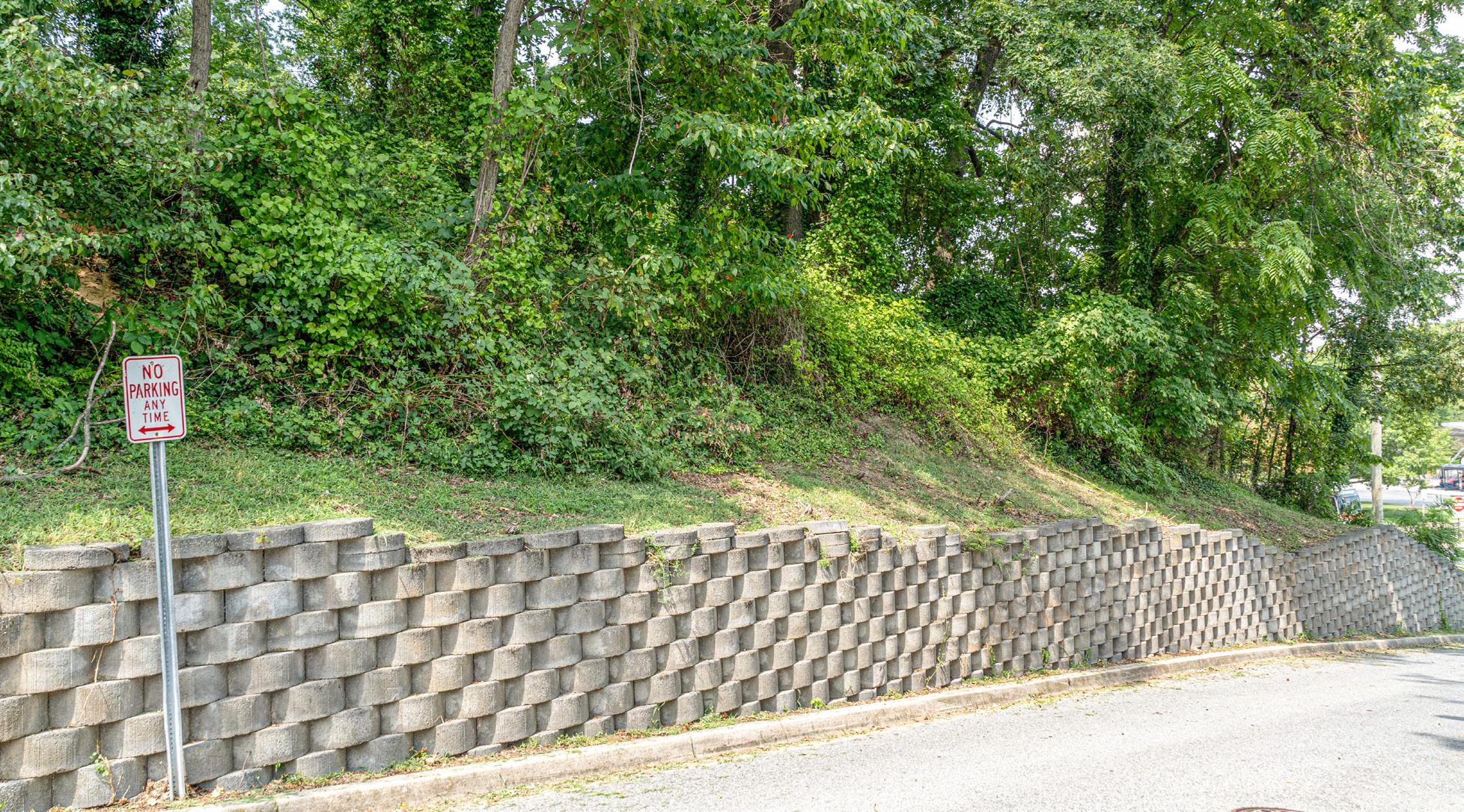
A vast majority of vacant lots have steep slopes (See Figure 6, Figure 7, and Map 9). Approximately 92 percent of vacant lots (or 178 lots) have slopes of 10 percent or greater within their lot boundary.
Land with slopes of less than 10 percent is the easiest to develop. Development costs begin to increase significantly on land with slopes greater than 15 percent. Approximately 79 percent of vacant lots (or 154 lots) have slopes of 15 percent or greater within their lot boundary. The most challenging to develop is land with slopes greater than 25 percent. Approximately 46 percent of vacant lots (or 90 lots) have slopes greater than 25 percent within their lot boundary.
Overall, the development potential of slopesensitive vacant lots depends on where these steep slopes fall within the lot, and how much of the lot’s area has them.
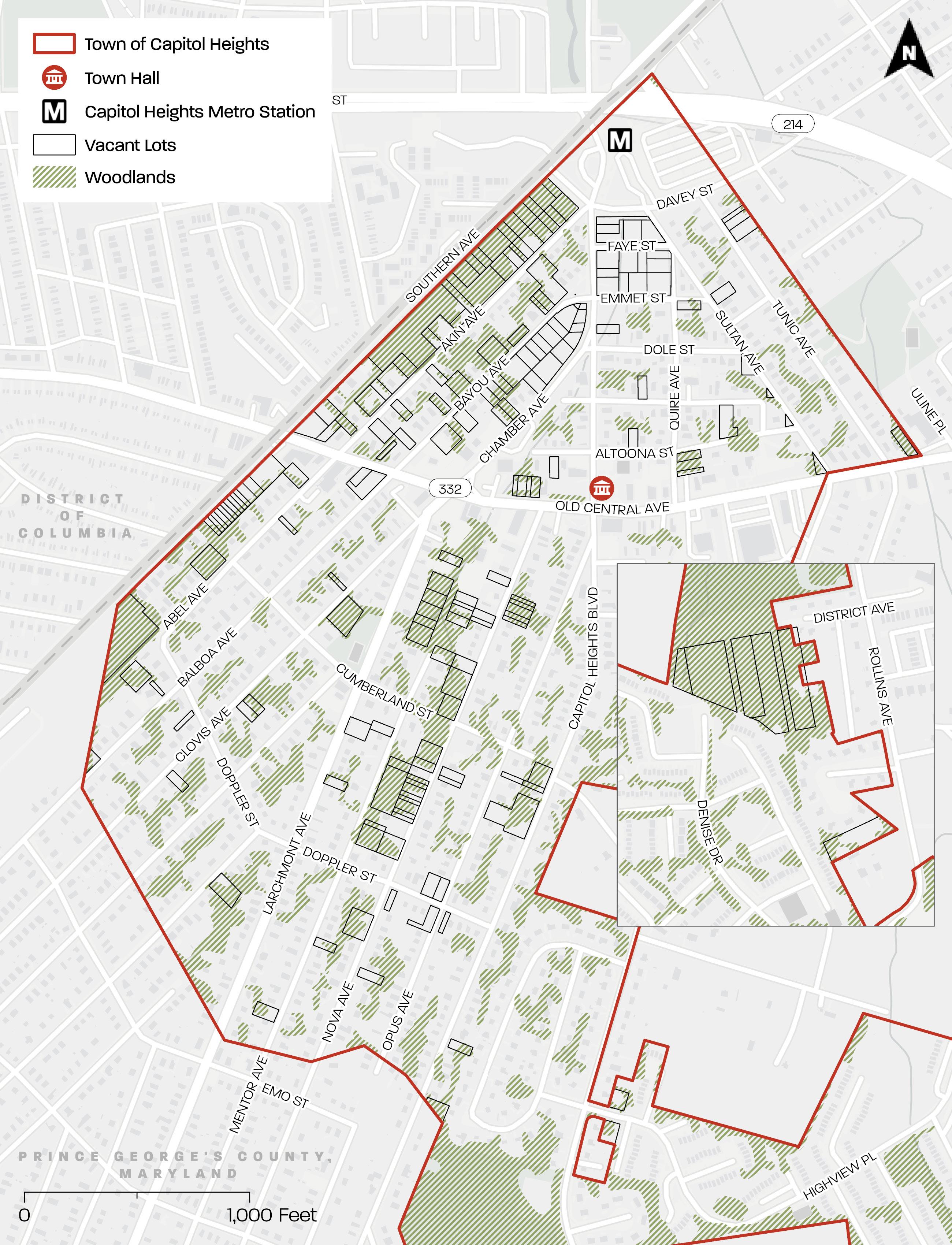
Map 10 depicts woodlands greater than 5,000 square feet or .10 acre within the Town, and the vacant lots that overlap these woodlands. Approximately 75 percent (or 146) of vacant lots overlap woodlands.
Division 2: Woodland and Wildlife Habitat Conservation Ordinance and Division 3: Tree Canopy Coverage Ordinance of Subtitle 25 of the County Code include tree canopy coverage requirements. According to Division 2, developing lots require a 15 or 20 percent woodland conservation or afforestation threshold depending on the zone. According to Division 3, developing lots with 5,000 square feet or greater of disturbance require a 10-15 percent minimum tree canopy coverage depending on the zone. Preserving existing tree canopy coverage on vacant lots could help owners/developers meet the tree canopy coverage requirements.
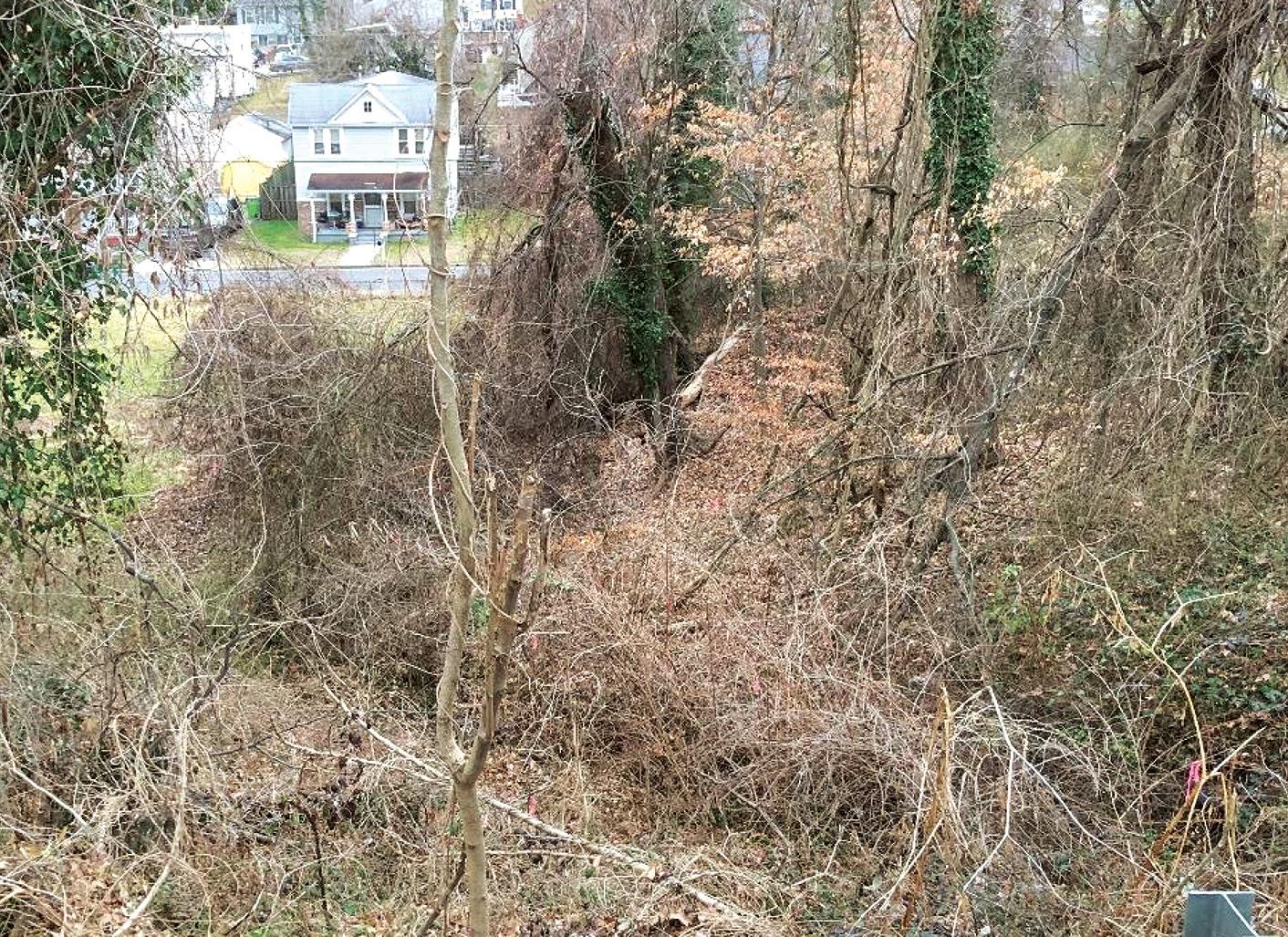
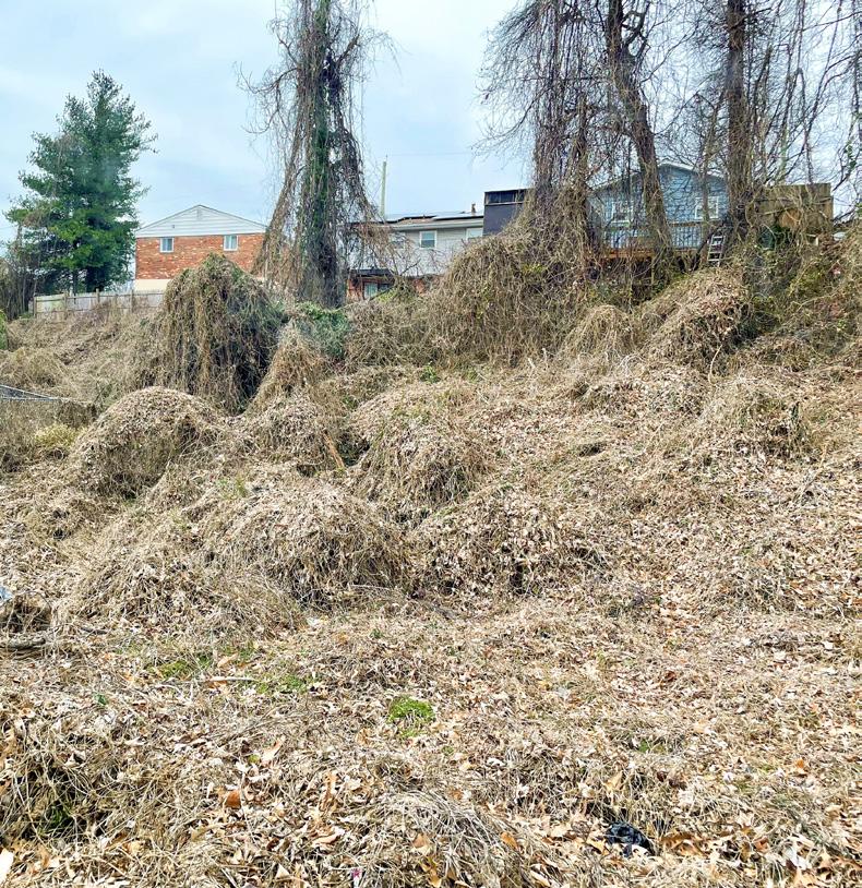
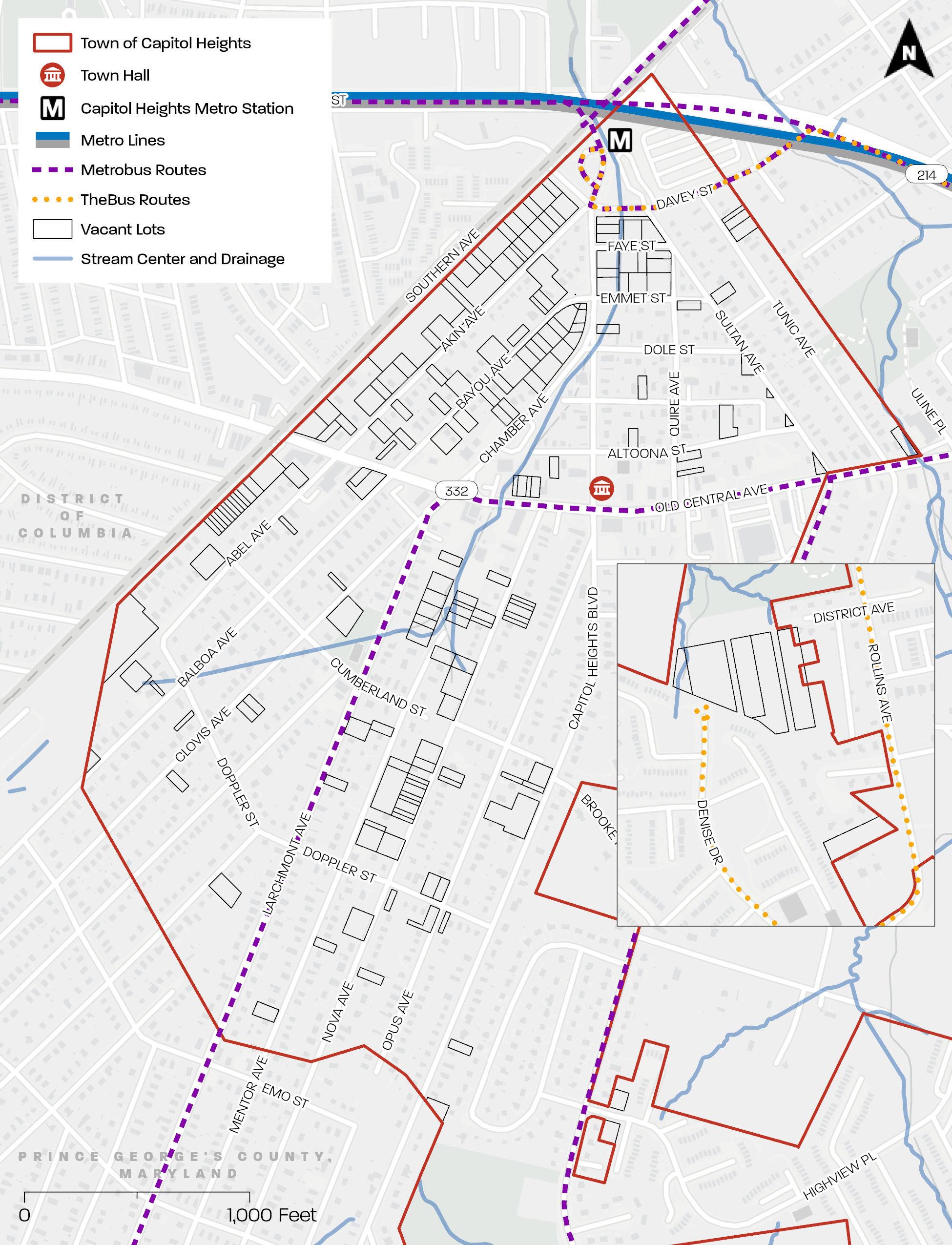
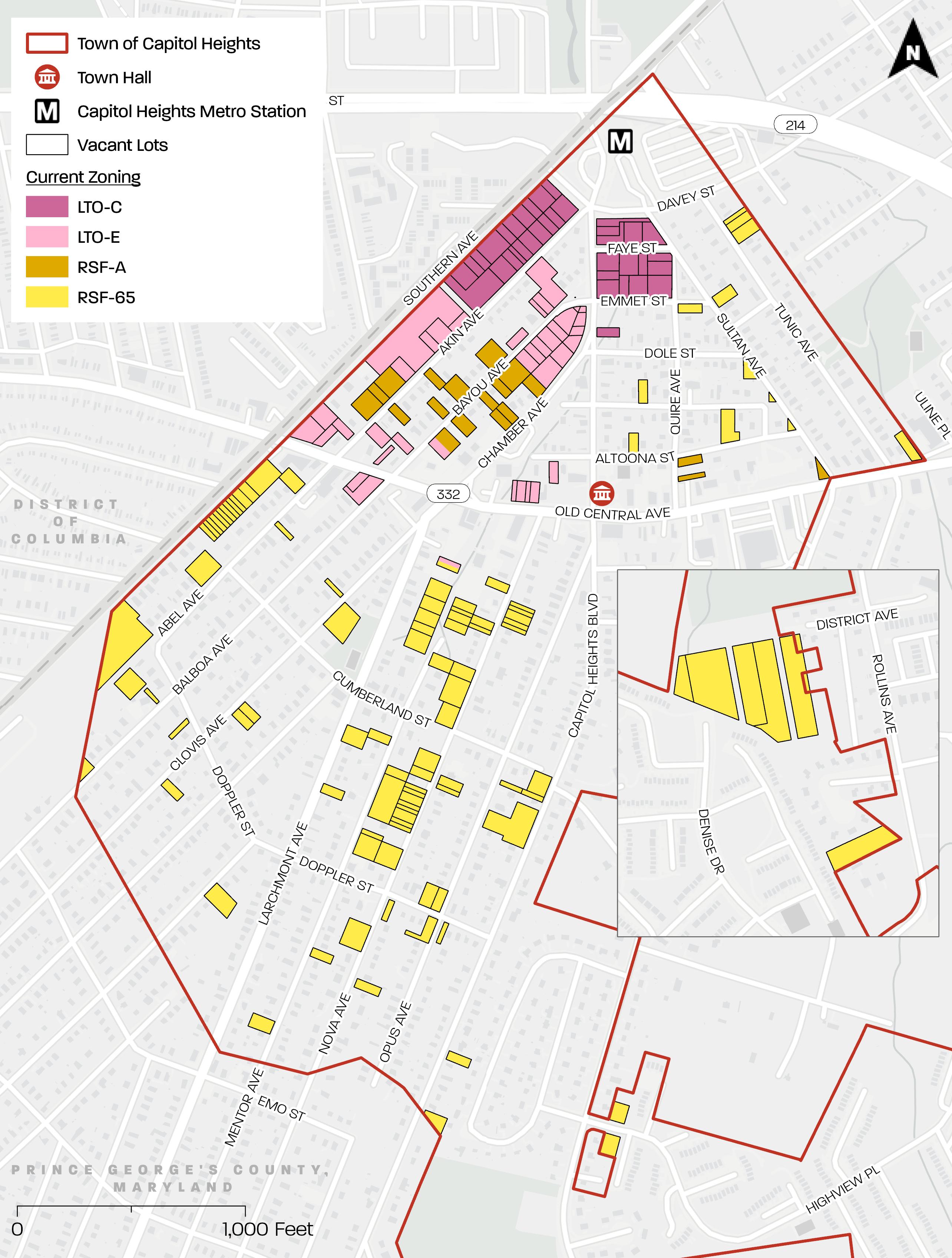
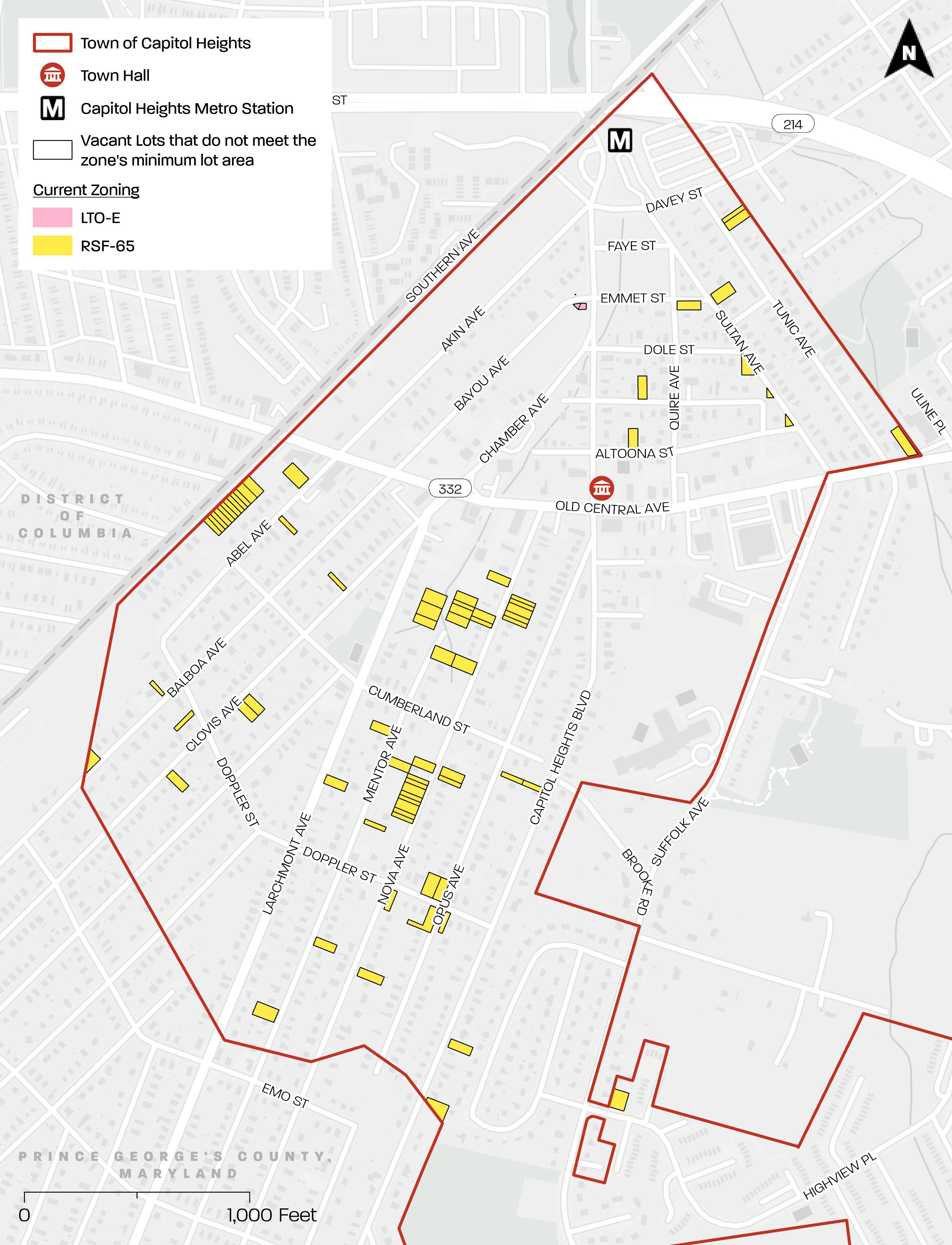
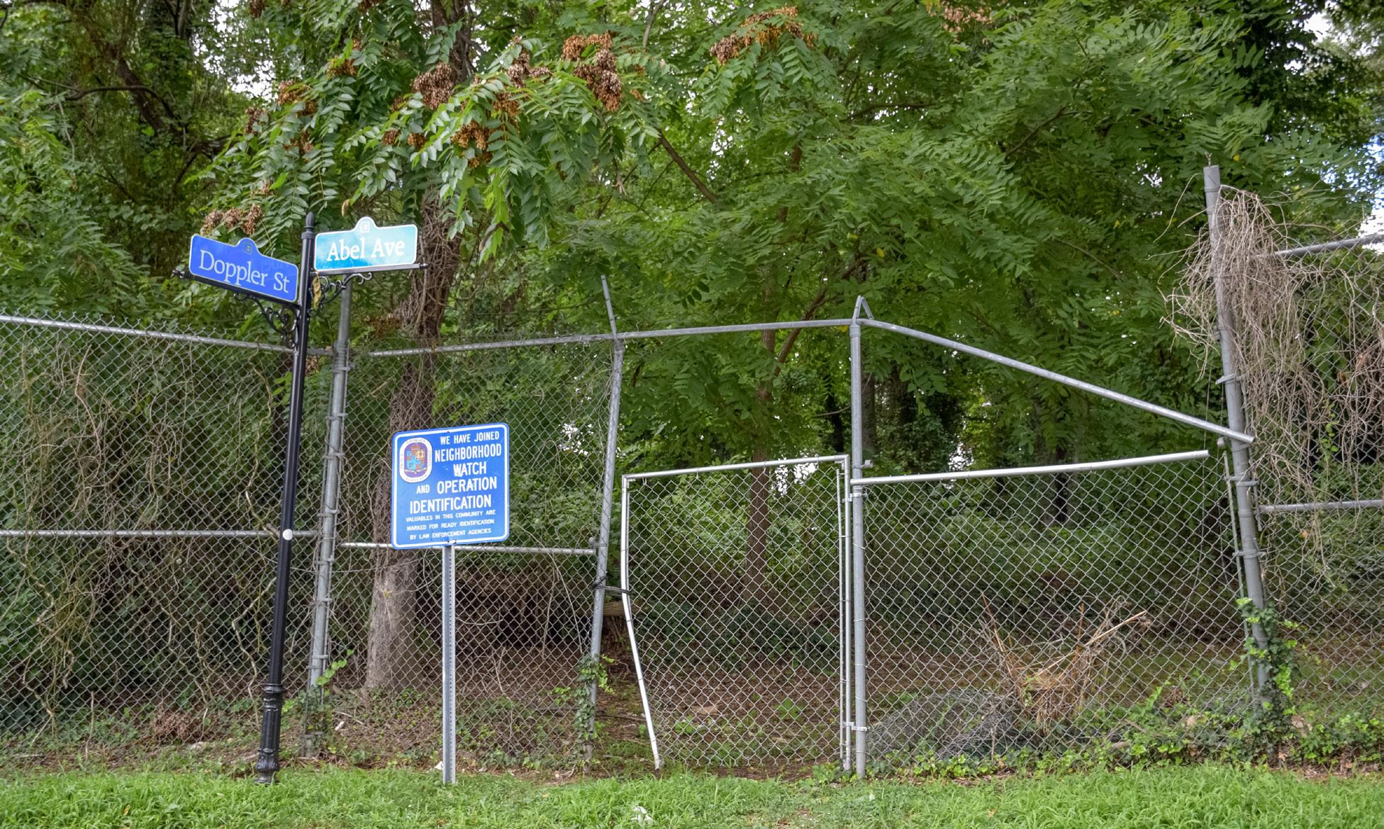
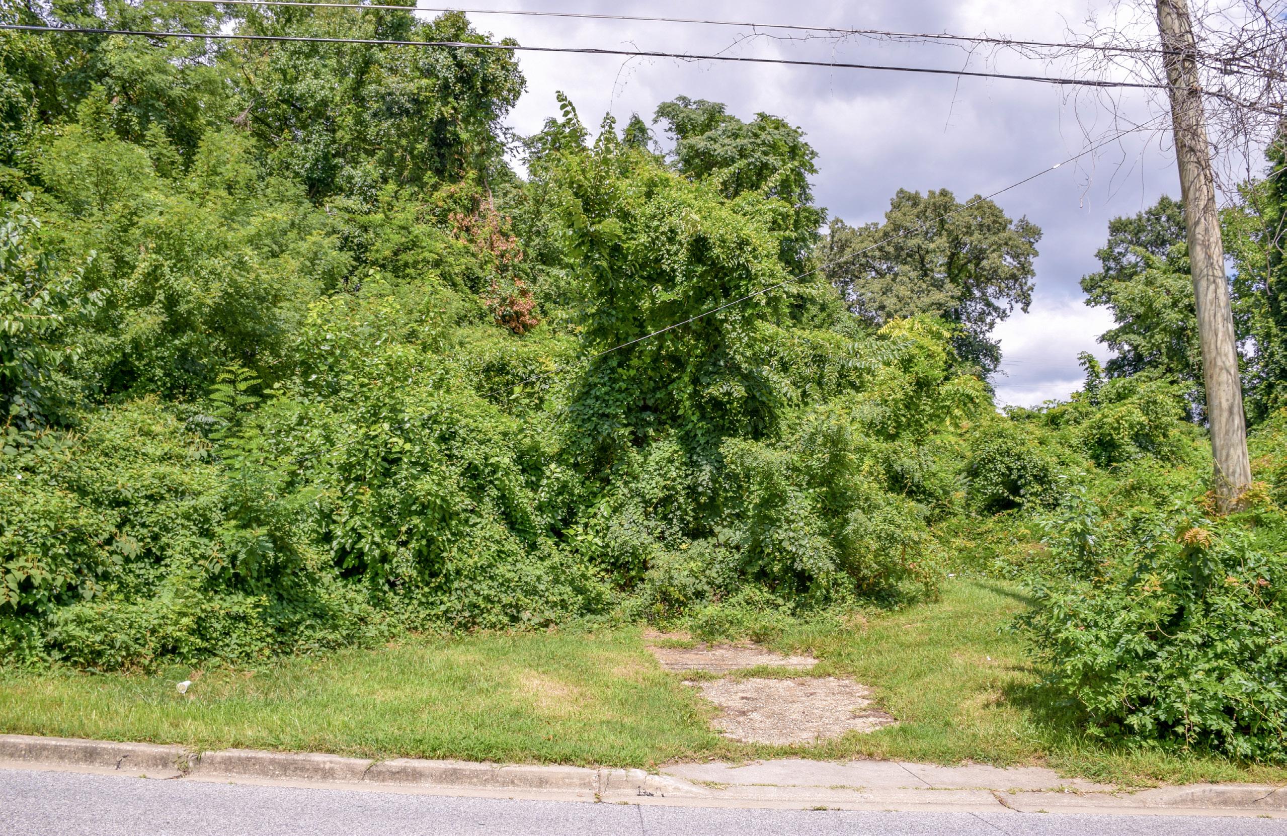
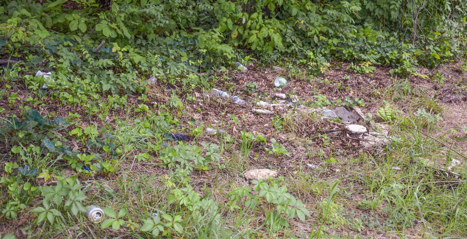
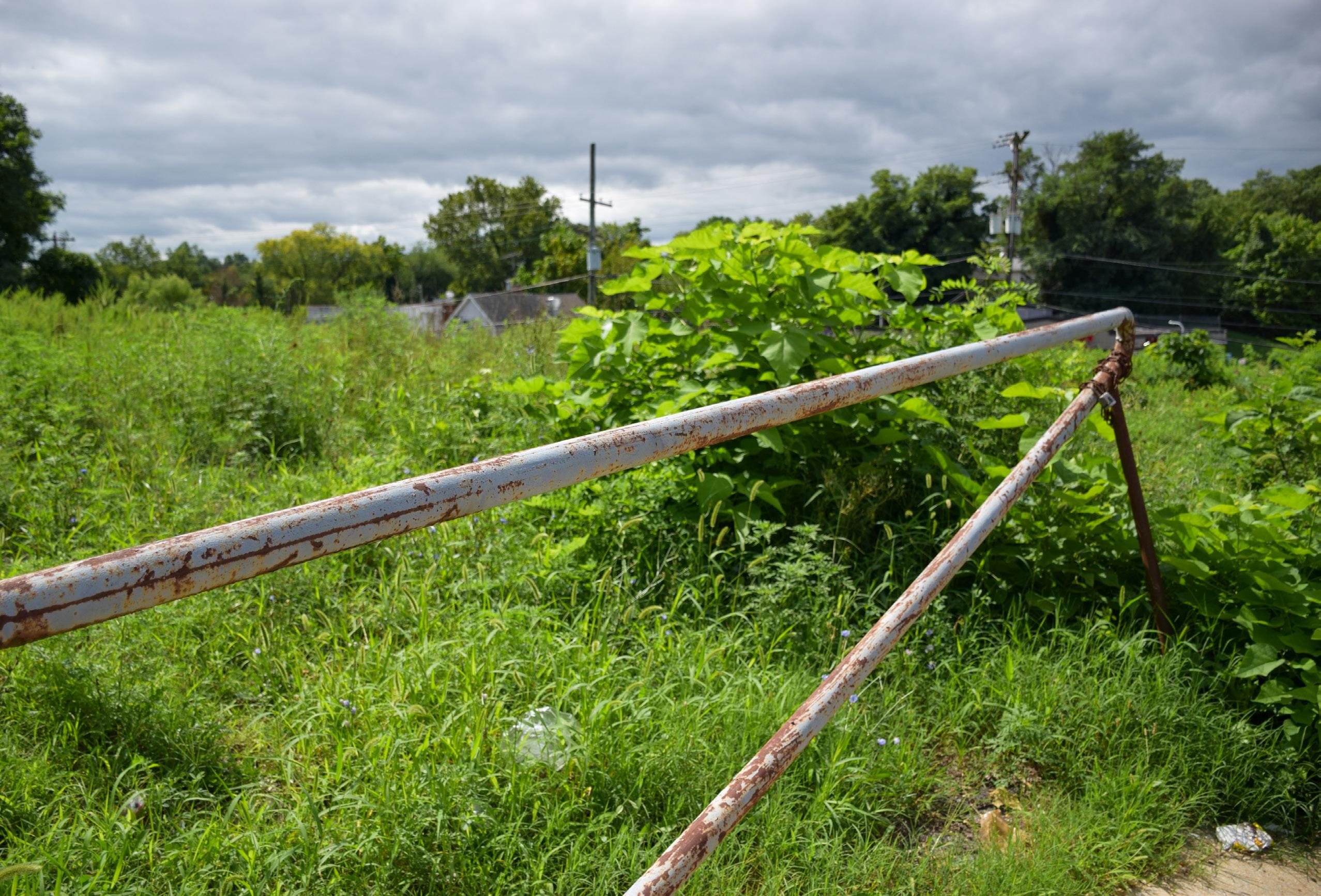
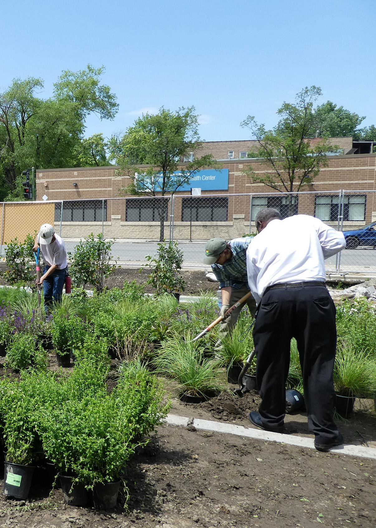
Figure 5 and Figure 6 depict examples of vacant lots with unmaintained, overgrown, and/or invasive vegetation. Owners can be faced with fines ranging from $50 for tall grass and weeds to $1,000 for dead trees (as of 2023).7 The Town has the authority to abate or clean up a vacant lot, the Town then bills the owner for the use of all materials (vehicle, gas, personnel) used in abatement. If the owner does not pay this bill within 30 calendar days, a lien is placed on the lot. Challenges created by unmaintained, overgrown, and/or invasive vegetation for owners and Town staff include, but are not limited to, the following:
• Some owners do not have the means, ability, or interest in maintaining vegetation.
• Properties must be cared for continually.
• Dying or dead trees on vacant lots create risks to neighboring property. “No dumping” signage does not appear to deter dumping.
• Unmaintained vegetation can harbor wildlife not desired in a residential neighborhood.
• Vacant lots require continual monitoring by Town staff to ensure the lots are adhering to the Town’s Property Standards Authority’s yard maintenance standards.
7 “Ordinance 2012-006,”
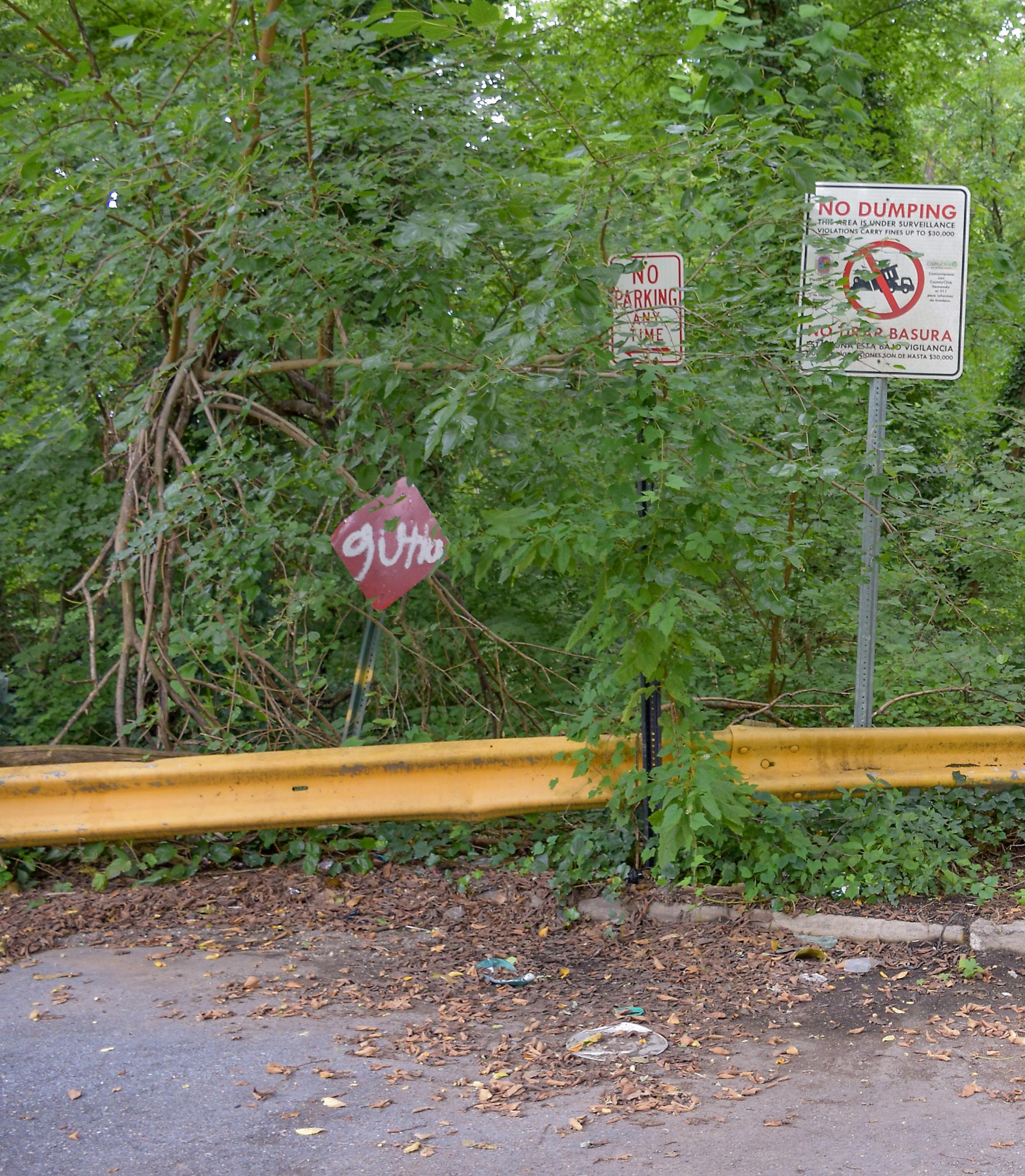
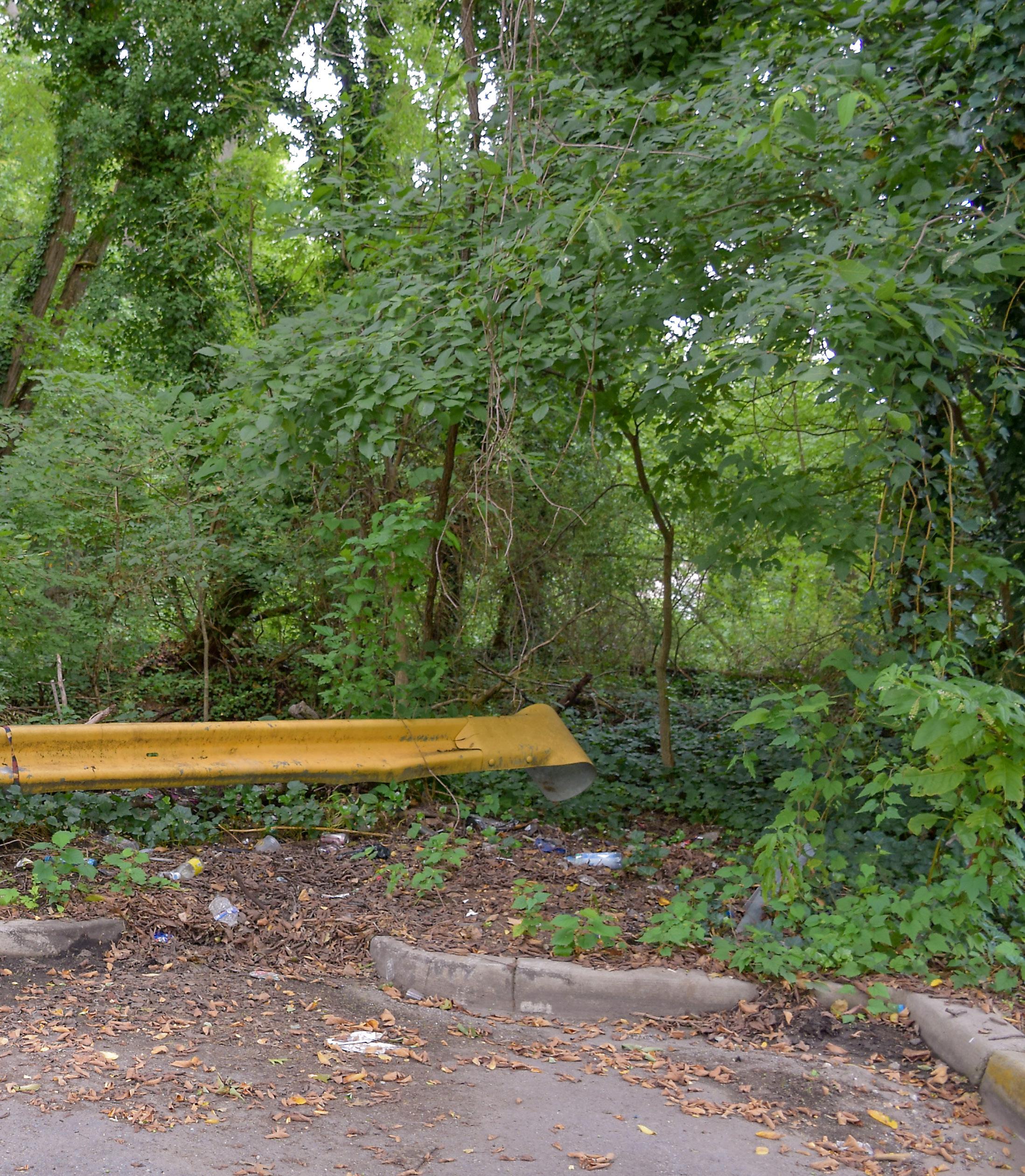
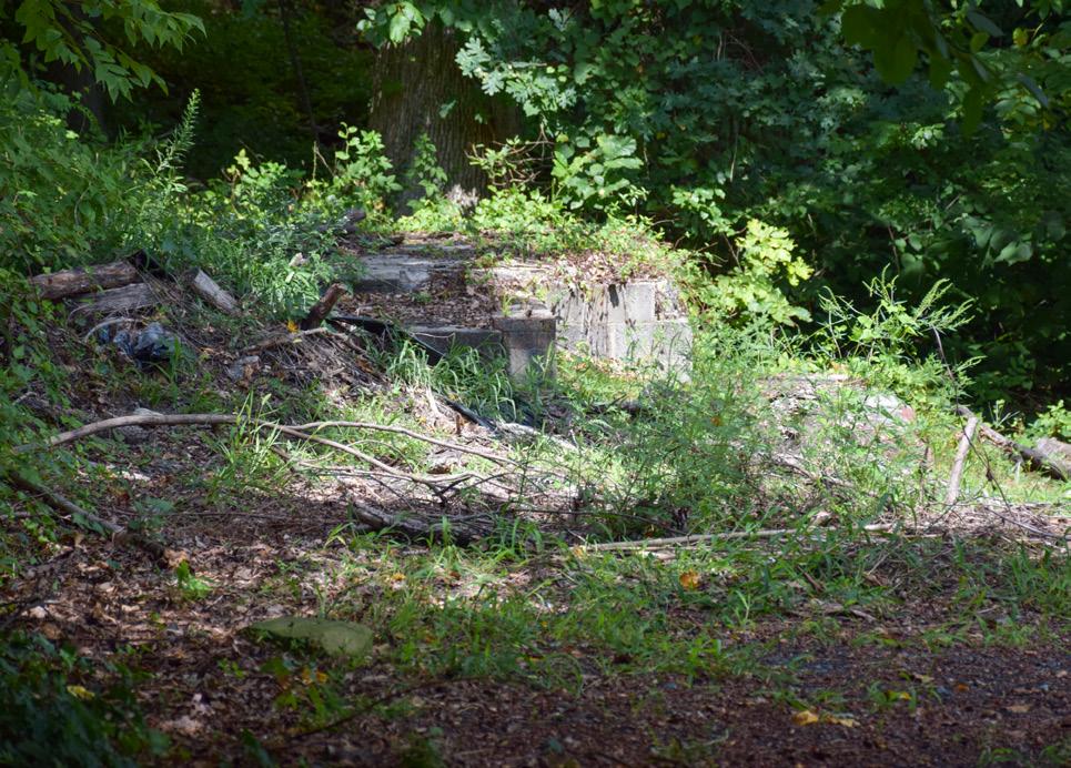
Many vacant lots harbor litter and illegally dumped items. Figure 4, Figure 7, and Figure 8 depict examples. The violation/fine, and enforcement and administrative process described in the Vegetation Maintenance section also applies to litter and dumping. As of 2023, owners could be faced with $1,000 fines for illegal dumping, bulk trash, etc. Challenges related to litter and dumping include, but are not limited to, the following:
• Major dumping occurs along gateways to the Town (Southern Avenue, Capitol Heights Boulevard, and Rollins Avenue).
• Poorly maintained vacant lots attract illegal dumping.
• Litter and dumped materials on vacant lots are not necessarily coming from the owner or even from Town residents. The Town faces enforcement challenges since they do not know who is responsible for the litter and dumped materials.
• “No dumping” signage does not appear to deter dumping.
• Dumped tires collect water and create a breeding environment for mosquitoes, leading to an increased presence of mosquitoes on neighboring lots.
The Town has a Vacant Lot Registry. Article II Vacant Lot Registration of the Town’s Ordinance 2019-1 (adopted February 11, 2019) requires owners to register their vacant lots annually and pay an annual fee. The Town also requires owners to submit a maintenance plan and an action plan for use of the lot; however, most owners do not register their vacant lots or submit or follow plans. Some owners do not respond to notifications, fines, or citations.
In many instances, it has been found that a non-responsive vacant lot owner does not know that he or she owns the lot or is deceased. Determining transfers of ownership and identifying next-of-kin has been a challenge for Town staff.
Overall, communication with vacant lot owners has been scant or unproductive. A noncompliant vacant lot owner may not meet deadlines for correcting violations and/ or may correct some issues but not others.

Overarching goals were identified to address vacant lot opportunities and challenges and prepare the Town to take advantage of opportunities presented by the County’s Blue Line Corridor TOD guidance and initiatives, including the Central Avenue-
Blue/Silver Line Sector Plan and Sectional Map Amendment currently underway. These goals provide a framework for near-term and long-term approaches to addressing vacant lots (see Figure 9).

1
Clean up and safeguard vacant lots.
In the near-term, vacant lots should be managed as well-maintained and litterfree open or natural spaces, positive public green space, or creative temporary uses until long-term plans are implemented. Vacant lots should be safeguarded to preserve their attractiveness and deter dumping and litter.
Vacant lot boundary and ownership information should be easily accessible to Town staff for communication, administrative, and code enforcement purposes.
Create a new mixed-use center near the Capitol Heights Metro Station. ACTION
2
1 The concentration of adjoining vacant lots near the Capitol Heights Metro Station and along Southern Avenue presents an opportunity for a developer in partnership with the Town and County to create a new mixed-use center. These vacant lots include those that are in gateway areas of the Town, are zoned LTO-C or LTO-E, and experience major dumping. ACTION
The new center should create a unified frontage aesthetic along Davey Street and major corridors and meet the goals of the County’s Blue Line Corridor TOD guidance and initiatives. New development within the new center should respect the existing scale of surrounding neighborhoods and the Town’s sense of place and community. New development should also incorporate existing natural features and provide innovative infill solutions on steeply sloped land in part through lot consolidation.
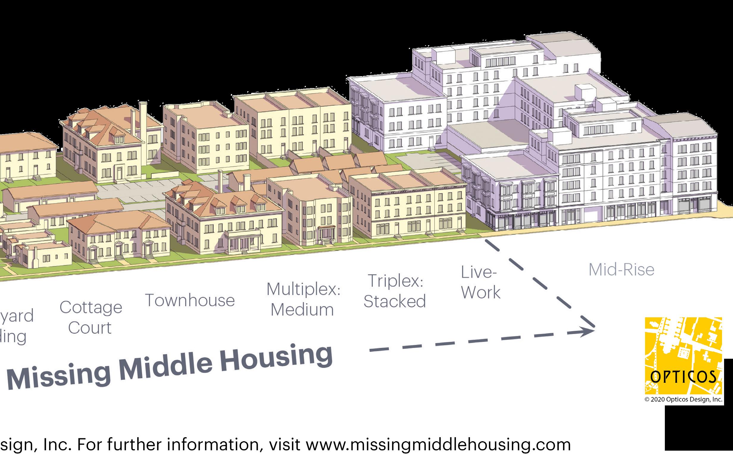
Vacant lots in the RSF-65 or RSF-A zones throughout the Town’s residential neighborhoods present an opportunity for residential infill development that contributes to missing middle and diverse housing types (for example, duplexes, live/work units, one-level accessible dwelling units) that increase homeownership opportunities. This diversity could be accomplished by supporting infill development on small vacant lots with incentives or combining contiguous vacant lots.
New residential development should be respectful of the existing scale of surrounding residences; small-scale development should be supported and embraced. New residential development should also be seamlessly integrated with natural features and the unique topography of the Town through, where appropriate, lot consolidation and County partnerships and initiatives.
Missing Middle Housing describes “homes between detached single-family and multifamily buildings. These types of homes add variety to the housing supply, support walkable places, and blend in with singlefamily neighborhoods.” Missing middle
housing types can include, but are not limited to, bungalows, duplexes, Townhouses, and cottage courts (i.e., group of small, detached structures arranged around a shared court visible from the street).8
8 Prince George’s County, MD, Housing Opportunity for All (2019), https://pgccouncil.us/DocumentCenter/View/4043/Housing-Opportunity-for-All_-REPORT.
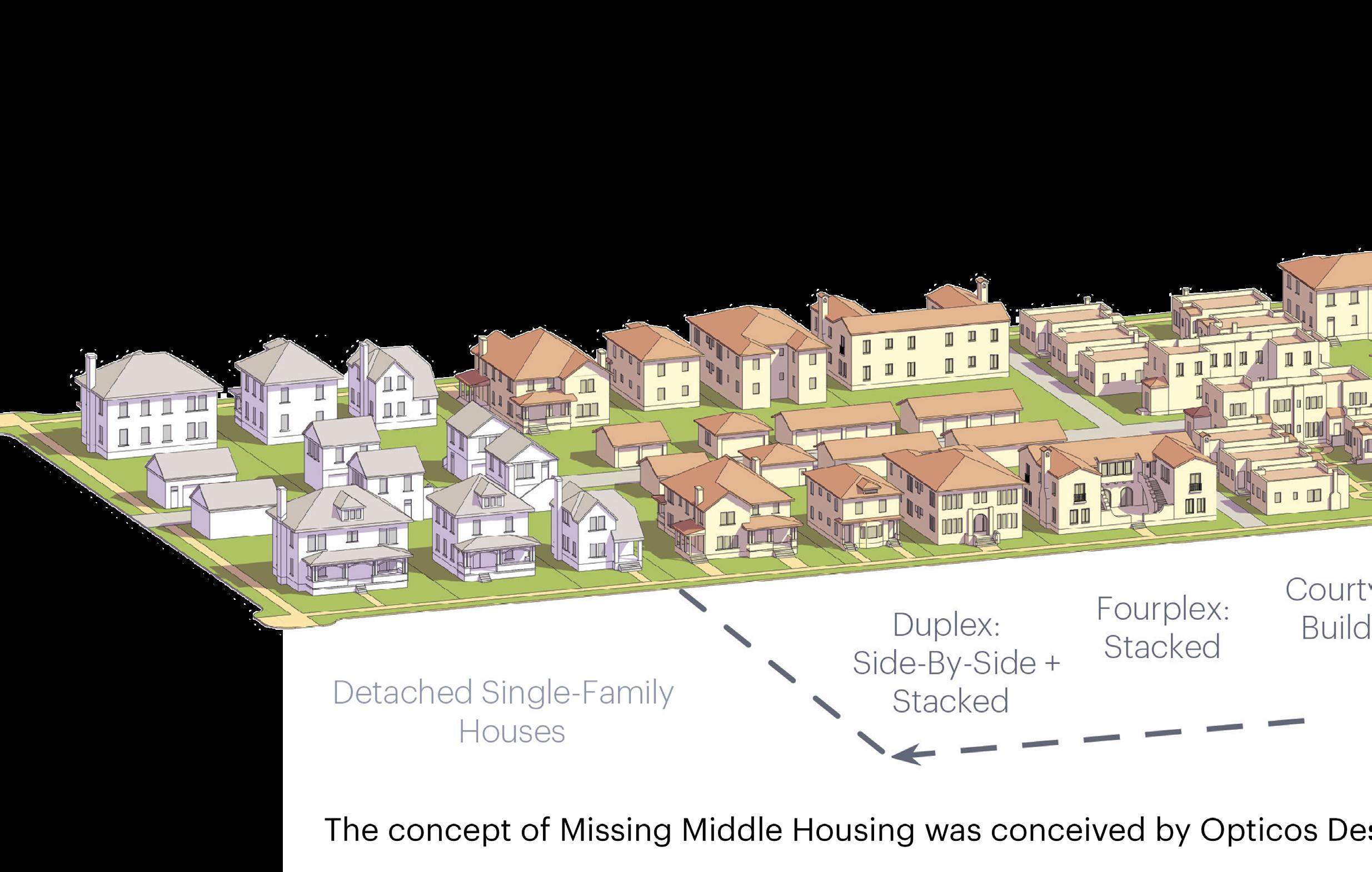
Figure 10 . Missing Middle Housing CREDIT: Opticos Design, Inc
Building from the goals, five recommendations provide near-term and long-term actions for addressing privately and publicly owned vacant lots.
1. 2.
Dedicate or pursue public-private partnerships to help clean up and maintain vacant land.
Leverage contiguous vacant lots to support future TOD and residential infill opportunities.
Provide technical support for vacant lot owners to understand what is allowable, and how they can overcome hurdles.
3.
Adopt a County small lot ordinance and develop a small house pattern book to streamline small lot residential infill development.
Consider incorporating some publicly owned lots into the broader open space network or transferring them to a private owner.
In the following section, each recommendation is accompanied by at least two implementation strategies that target vacant lot types or focus areas where appropriate. Maps depict these focus areas. Considerations and case studies, where appropriate, are also provided for the implementation strategies.
1
Dedicate or pursue public-private partnerships to help clean up and maintain vacant land
1.1
Evaluate beautification initiatives or create a new program to support clean-up of vacant lots
The Town should implement an education campaign for code enforcement with the goal to educate vacant lot owners on the Town’s requirements for vacant lots, the owner’s responsibilities, and potential consequences for not adhering to the Town’s requirements. The education campaign should highlight:
• The Town’s vacant lot registration process (including where to find the Vacant Lot Registration Form)
• Vacant lot standards (maintenance expectations)
• Code enforcement and notification process
• Fines for code violations
• Most common code violations
• Available Town and County resources for cleaning up vacant lots
• Trash pick-up and bulk item pick-up/dropoff information
• Special Town events (for example, a “Green Up, Clean Up” event where owners can drop off unwanted bulk items free-of-charge for disposal)
• Frequently Asked Questions
• Contact information
The education campaign could include mailed newsletters; brochures or informational fliers posted at the Town Hall and businesses where public information is displayed; educational booths at community events; virtual events; and/or pop-up educational events. Pop-up educational events could be hosted on a Town-owned vacant lot to demonstrate that vacant lot challenges are not unique to private owners. A pop-up education event could also be hosted in conjunction with other events or in partnership with community organizations/ groups or churches to attract residents.
As part of the educational campaign, the Town’s website should be updated with a Vacant Lot page so that the previously described list of information, the Vacant Lot Registration Form, Vacant lot registry fee, and violation fines are available and easily accessible. As other strategies within this chapter are implemented over time, the Vacant Lot section could also be updated with the following:
• Website links to resources for cleaning/ safeguarding vacant lots (Strategies 1.1 and 1.3)
• County small lot ordinance and
Philadelphia, PA Pennsylvania Horticultural Society’s LandCare Program
The City of Philadelphia’s LandCare Program works with local businesses and communities to transform tens of thousands of abandoned publicly and privately owned land into micro-parks through a process called “greening.” The city contracts with the Pennsylvania Horticulture Society (PHS) to manage the program, which includes the following initiatives:
Initiative 1: Clean and Green: Targets vacant parcels in neighborhoods without open or green space. PHS hires citybased landscape contractors to clean and mow the lots twice a month from April to October and install simple wooden fences.
Initiative 2: Community LandCare: Works with community organizations to hire residents to perform landscape maintenance work on vacant lots.
Vacant lots do not have to be publicly owned to participate in the program. Private owners of neglected lots are put on
associated overlay zone (Strategy 3.1)
• Small House Pattern Book (Strategy 3.2)
• Handbook of practical ideas for development/uses of vacant lots (Strategy 4.1)
• Events where vacant lot owners can receive site-specific guidance (Strategy 4.2)
• Side Lot Program information (Strategy 5.1)
notice and have 10 days to clean up their lots. If they do not, then the city’s Department of Licenses and Inspections grants PHS right of entry to abate nuisance on the lot. 10 The program is only implemented where communities desire. New sites are selected by community members.
The LandCare program began with a pilot program from 1996-2003, followed by the citywide program launching in 2004. 11 As of 2021, more than 13,000 lots are under the Philadelphia LandCare Management program. 12
Benefits of the program have included:
• New job opportunities.
• Increased property values. A 2022 study showed that lots within 1,000 feet of a greened lot experienced a 4.3 percent rise in value after the first year and a 13 percent cumulative increase after 6 years. The cost to green a lot is $2,500, and annual maintenance is roughly $400, a total price that is significantly lower than the exponential value by which it increases. 13
10 Loesch, Maggie, “Greening Vacant Lots: Low Cost, Big Effect in Philly,” Shelterforce, November 13, 2018, https://shelterforce.org/2018/11/13/greening-vacant-lots-low-cost-big-effect-in-philly/ 11 Philadelphia LandCare,” Lincoln Institute of Land Policy, accessed December 11, 2023, https://phsonline.org/programs/transforming-vacant-land
12 “Transforming Vacant Land,” Pennsylvania Horticultural Society, accessed December 11, 2023, https://phsonline.org/ programs/transforming-vacant-land
13 “Wharton Research Shows Revitalizing Vacant Lots Pays Dividends,” Analytics at Wharton News, The Wharton School, The University of Pennsylvania, last modified February 6, 2023, accessed December 11, 2023, https://analytics.wharton.upenn.edu/ research/impact-analytics/landcare-pays-dividends/
Identify multijurisdictional solutions to address illegal dumping along major corridors .
Focus Area: Vacant lots along Southern Avenue (see Map 11).
The Town and Washington, DC should collaborate to identify methods to deter illegal dumping and provide the region’s residents with easy, accessible, and costeffective ways to properly dispose of bulk trash. Washington, DC’s Department of Public Works Solid Waste Education and Enforcement Program (SWEEP) could be a
good partner for identifying multijurisdictional solutions. SWEEP’s inspectors and investigators work with residents and businesses to keep Washington, DC clean, provide a variety of educational services, support neighborhood cleanups through the Helping Hand program, and give young people the opportunity to earn community service credits through the SWEEP Jr. program.9 For more information on SWEEP, see https://dpw.dc.gov/service/solidwaste-education-and-enforcement-sweep
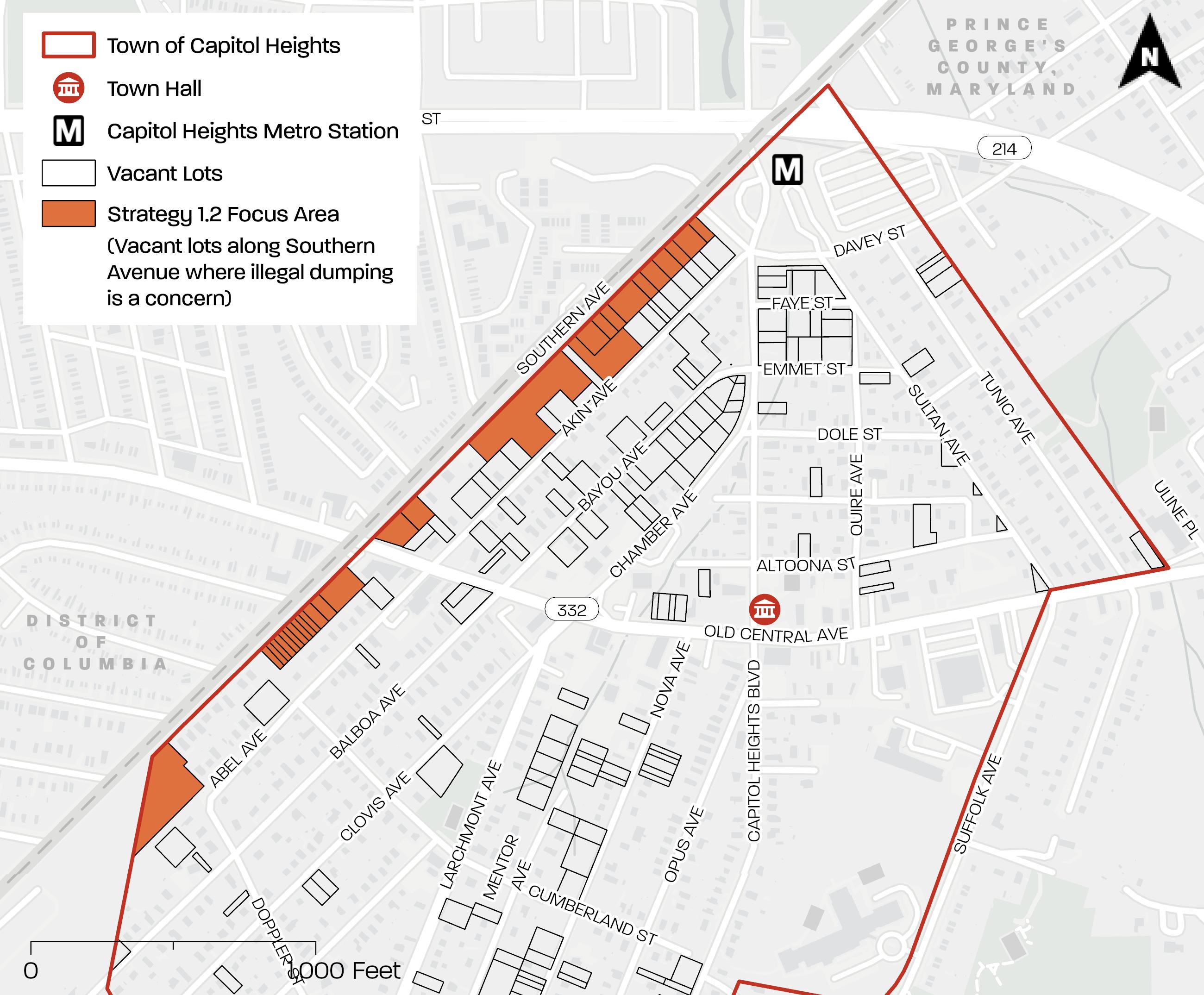
Map 11 . Strategy 1 . 2 Focus Area
Source: PGAtlas com
9 “Solid Waste Education and Enforcement – SWEEP,” Department of Public Works, District of Columbia, accessed December 11, 2023, https://dpw.dc.gov/service/solid-waste-education-and-enforcement-sweep
Pursue funding strategies and County resources to clean/safeguard vacant lots.
Focus Area: Privately owned vacant lots.
In many cases, the owners of vacant lots do not have the means to maintain and safeguard their land. The Town should pursue grants to establish a Vacant Lot Maintenance Program. The Town and the owner would enter into an agreement allowing the Town to access the lot for maintenance purposes. The agreement would define “maintenance” and include an access schedule.
Using grant funds, the Town would contract with a third party to perform maintenance services on the lots in the Vacant Lot Maintenance Program. Maintenance services might include site clearing, mowing, and debris removal.
The Town could also leverage the sale of valuable Town-owned vacant lots near the Capitol Heights Metro station to provide funding to community groups for cleaning up lots, safeguarding them, and implementing their improvements. These Town-owned vacant lots include the lots bordered by Davey Street, Capitol Heights Boulevard, Emmet Street, and Quire Avenue; and the lots bordered by Bayou Avenue, Capitol Heights Boulevard, and Chamber Avenue.
Private owners of vacant lots could also utilize the County’s sustainability programs to clean up and/or implement stormwater retrofits on their vacant lots. These programs provide technical assistance, materials, and/ or long-term maintenance for cleanup and stormwater projects on lots. Implementation would require Town and/ or County involvement to: 1) identify appropriate and potentially interested vacant lot owners; 2) educate owners on these programs; and 3) coordinate these owner’s participation in these programs.
The Volunteer Neighborhood Cleanup Program is a community-sponsored volunteer program that enables DoE to partner with civic and homeowner associations, local businesses, and nonprofit organizations. Both neighborhood cleanups and stream cleanups are included under this program. DoE’s Sustainability Division provides each interested community with technical assistance and materials such as trash bags, gloves, and may include roll-off dumpsters depending on availability.14 The Town could match private owners of vacant lots with local community organizations/groups who are interested in performing cleanups on an ongoing basis. For more information on the Neighborhood Cleanup Program, see https://www. princegeorgescountymd.gov/departmentsoffices/environment/sustainability/getinvolved/volunteer-opportunities
In 2015, the County entered a 30year community-based public-private partnership with Corvias (an organization supporting public/private partnerships) to improve stormwater infrastructure through disadvantaged subcontractor development and utilization. Through the CWP, Best Management Practices (BMPs) are planned, designed, and constructed on lots that range from schools, libraries, and churches to municipal sites and residential communities.
14 “Volunteer Opportunities,” Prince George’s County, MD, accessed December 11, 2023, https://www. princegeorgescountymd.gov/departments-offices/environment/sustainability/get-involved/volunteer-opportunities. “Volunteer Opportunities,” Prince George’s County, MD, accessed December 11, 2023, https://www.princegeorgescountymd.gov/ departments-offices/environment/sustainability/get-involved/volunteer-opportunities
The CWP has a team of planners, engineers, construction companies, and outreach staff who understand local site conditions, BMP designs, regulations, and community issues. Once the location for a BMP is selected, the CWP works with residents and lot owners to make sure the projects are a good fit. The CWP performs functional maintenance—including repair/ restoration of BMPs, life cycle maintenance, repair to structural integrity of outfalls, and more—on all projects installed under the program for 30 years. Thereafter, the County assumes responsibility.15 For more information on the CWP, see https:// thecleanwaterpartnership.com/
The Alternative Compliance Program is a voluntary program for tax-exempt, faithbased, or other 501(c)(3) organizations that reduces their Clean Water Act stormwater fee in exchange for the CWP constructing and maintaining a small BMP on their lot. The Town has 11 vacant lots that are owned by faithbased institutions. Under the Alternative Compliance Program, County-based minority business enterprises (MBE) are included in the design, installation and the long-term maintenance of the devices.16 For more information on the Alternative Compliance Program, see: https://www. princegeorgescountymd.gov/departmentsoffices/environment/stormwatermanagement/rain-check-rebate-program/ alternative-compliance
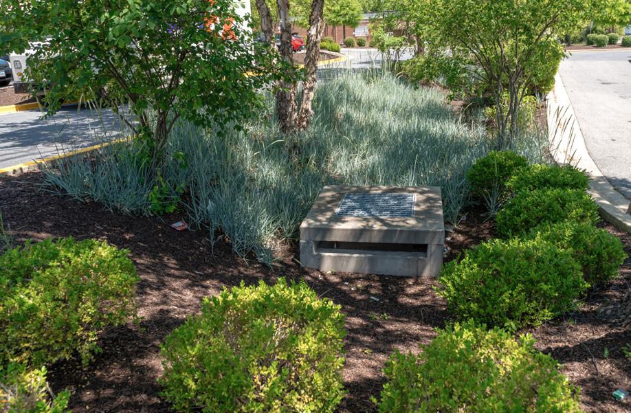
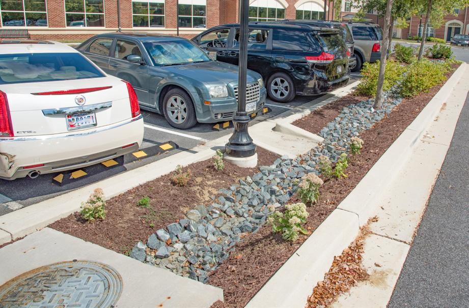
A Best Management Practice BMP is a technique used to reduce the volume and rate of stormwater runoff and filter the pollutants found in the runoff. These techniques and devices are located at collection or discharge points along the drainage path. BMP types that are being installed as part of the CWP program include the following: bioretention, bioswales, impervious pavement removal, micro-bioretention, outfall protection, pocket sand filters, pond retrofits, regenerative stop pool storm conveyance, stream restorations, submerged gravel wetland, tree box filters, tree plantings, and wet swales.17
15 Prince George’s County Clean Water Partnership,” The Clean Water Partnership, accessed December 11, 2023, https://thecleanwaterpartnership.com/
16 “Alternative Compliance,” Prince George’s County, MD, accessed December 11, 2023, https://www.princegeorgescountymd. gov/departments-offices/environment/stormwater-management/rain-check-rebate-program/alternative-compliance
17 Clean Water Partnership, Frequently Asked Questions (n.d.), https://e58070.p3cdn1.secureserver.net/wp-content/ uploads/2017/12/CWP_FAQ_120817.pdf
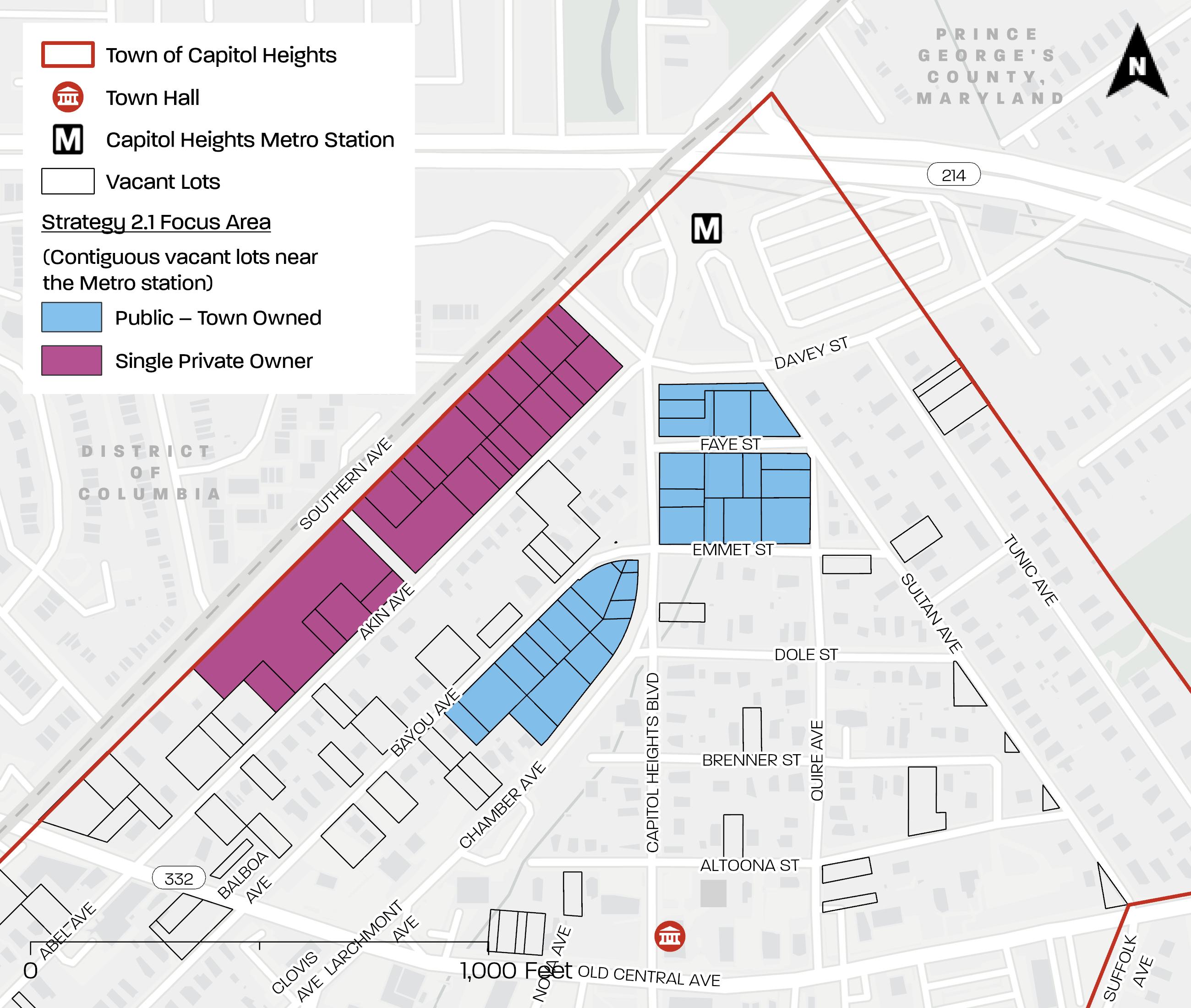
Leverage contiguous vacant lots to support future Transit Oriented Development and residential infill opportunities
Initiate a request for proposal for redeveloping eligible vacant lots near the Capitol Heights Metro Station.
Focus Area:
• Contiguous Town-owned vacant lots near the Capitol Heights Metro Station
• Contiguous privately owned vacant lots between Southern Avenue and Akin Avenue
The Town owns valuable vacant land within walking distance from the Capitol Heights Metro Station (see Map 12). It is recommended that the Town prepare a solicitation package for the development of this land. The solicitation would include a description of the Town-owned vacant
lots, the Town’s development objectives, development proposal requirements, and evaluation criteria. The Town would enter into an agreement or a memorandum of understanding with appropriate parties. The timing of the solicitation should leverage investment momentum generated by Blue Line projects nearby.
The Town should also encourage developers to assemble privately owned vacant lots adjacent to the Town’s lots to maximize economic impact.
Map 12 . Strategy 2 . 1 Focus Area
Source: PGAtlas com ; https://sdat dat maryland gov/RealProperty/Pages/default aspx
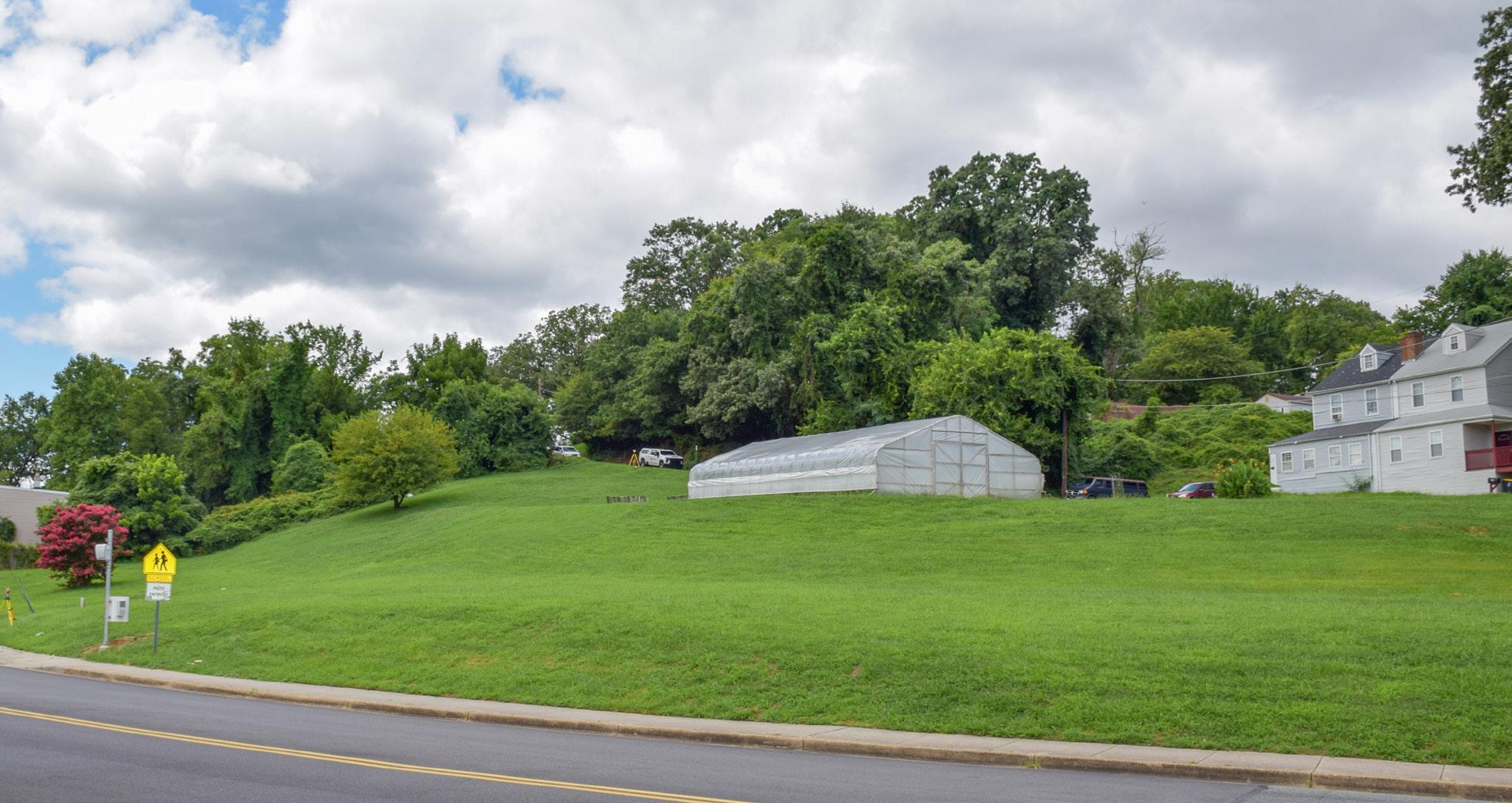
Figure 11 depicts Town-owned vacant lots near the Capitol Heights Metro Station available for redevelopment. Note that the greenhouse use has ended since the photo in this figure was taken.
Figure 12 depicts privately owned vacant lots also near the Capitol Heights Metro Station that are owned by a single owner and could be assembled.
CREDIT:
12
CREDIT: M-NCPPC
Establish common development interest among two or more lot owners to combine/sell contiguous vacant lots via a broker for residential infill.
Focus Area: Contiguous vacant lots with different owners (see Map 14 where each owner is depicted by a distinct color).
Lot owner outreach may be necessary to unlock vacant lot development potential. It may be that owners simply do not understand their lot’s value.
New development should be sensitive to the scale of surrounding residences. Residences near the Capitol Heights Metro Station and along Akin Avenue are predominately one- to two-story singlefamily dwellings with front setbacks of at least 20 feet. Vacant lots near the Capitol Heights Metro Station are currently zoned as LTO-C or LTO-E. These zones allow for moderate-intensity mixed-use development, a maximum principal structure height of 70 or 80 feet (approximately 7-8 stories) and a minimum front yard depth of 0 or 10 feet depending on the zone. As smaller vacant lots are consolidated into larger vacant lots for redevelopment, the massing and siting of new development should complement surrounding existing development.
Slope-sensitive vacant lots present opportunities for creative infill solutions. Development costs increase on lots with slopes of 15-25 percent; lots with slopes greater than 25 percent are even more challenging to develop. A majority of vacant lots near the Capitol Heights Metro Station and between Southern Avenue and Akin Avenue have these types of slopes. Consolidating smaller contiguous lots could create an opportunity for new development to avoid or minimize construction on steep slopes. The remaining steeply sloped areas could be set aside as green space. These steeply sloped lots and other vacant lots have unmaintained, overgrown, and/ or invasive vegetation that may require significant clearing and the removal of litter and dumped objects prior to development. See Recommendation 1 for how to address this challenge.
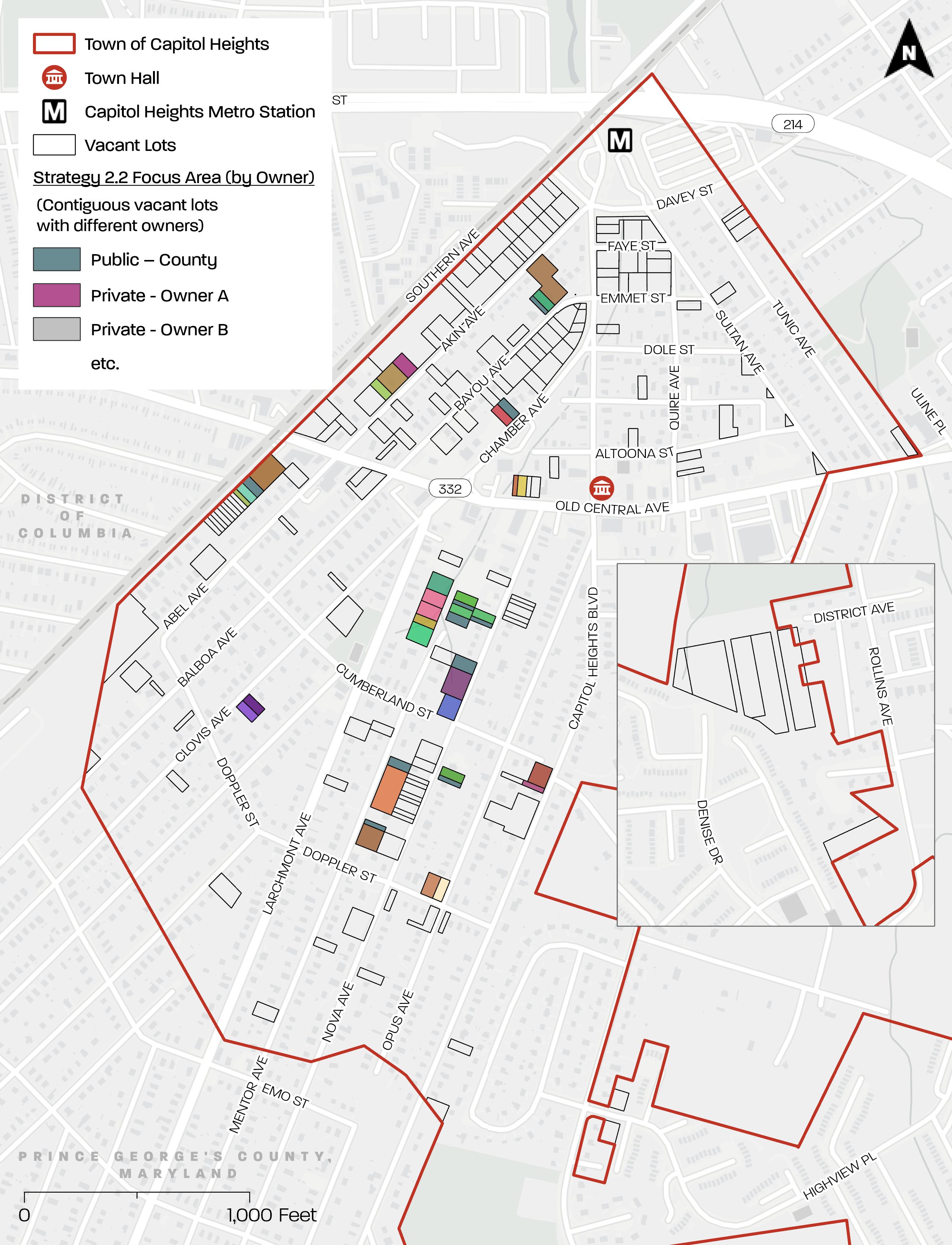
Map 14 . Strategy 2 . 2 Focus Area
Source: PGAtlas com ; https://sdat . dat . maryland gov/RealProperty/Pages/default . aspx
Adopt a County small lot ordinance and develop a small house pattern book to streamline small lot residential infill development .
Develop and adopt a County small lot ordinance.
Focus Area: The County, in collaboration with the Town, could develop and adopt a small lot ordinance and development parameters for lots that would streamline the application, review, and approval process for development on vacant lots that are too small to meet the current zoning’s minimum lot area.18
The small lot ordinance would remove regulatory barriers (for example, variance process) for owners who desire to develop their small vacant lots.
The National Association of Home Builder’s 2019 Diversifying Housing Options with Smaller Lots and Smaller Homes could be a helpful reference if and when the County develops a small lot ordinance. The report:
• Explores issues involved in building a greater mix of housing types that bring discreet density to neighborhoods using a collection that ranges from smaller dwellings to accessory dwelling units, to missing middle housing types.
• Aims to provide an understanding about the regulatory and design options as well as the barriers that currently limit or prevent these housing types.
• Analyzes examples of codes and built results that were developed at the market rate without the expectation of subsidies so that we could understand how successful a code can be in influencing diversity and affordability of housing options.
The report’s Chapters 2 and 3 include case studies of small lot ordinances and density incentives, including challenges and lessons learned.19 To view the report, visit: https:// www.nahb.org/-/media/NAHB/advocacy/ docs/top-priorities/housing-affordability/ nahb-2019-small-homes-research-report. pdf
Develop a pattern book of smaller dwellings and small-lot infill development guidelines.
Focus Area: Privately owned vacant lots that do not meet the Zoning Ordinance’s minimum lot area and are not contiguous with vacant lots under the same ownership (see Map 15).
The Prince George’s County Planning Department’s PAMC program partners with local colleges and universities to develop a pattern book of small house prototypes for small lots that would be able to assist
with this strategy. The State of Maryland has introduced legislation to promote and encourage the creation of ADUs on lands zoned for single-family use. (SB-0871).
18 The Maryland Regional District Act gives zoning authority to Montgomery and Prince George’s Counties.
19 National Association of Home Builders, Diversifying Housing Options with Smaller Lots and Smaller Homes (2019), https:// www.nahb.org/-/media/NAHB/advocacy/docs/top-priorities/housing-affordability/nahb-2019-small-homes-research-report.pdf
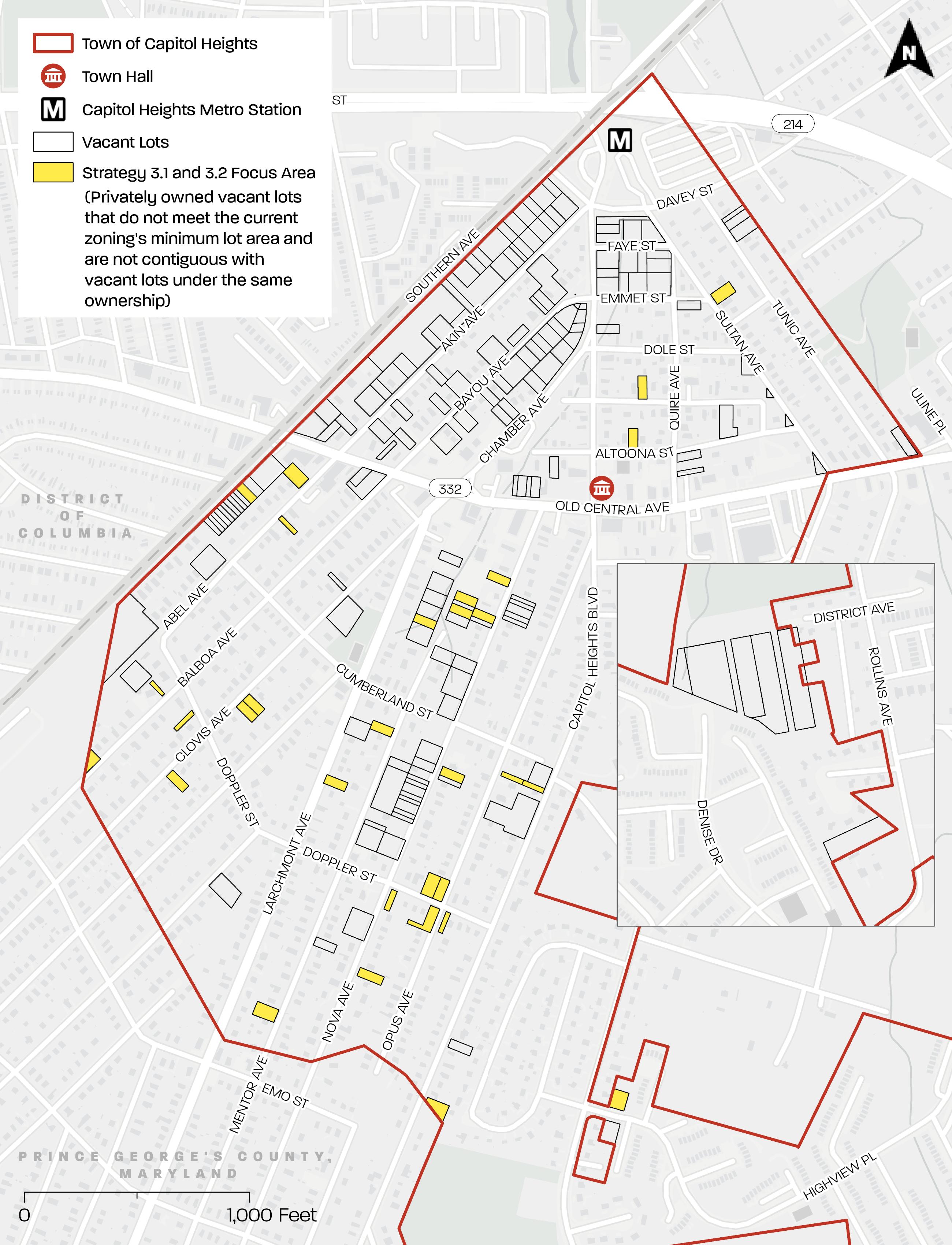
Map 15 . Strategy 3 1 and 3 2 Focus Area
Source: PGAtlas com ; Prince George’s County Zoning Ordinance
ADU (detached, most private)
ADU (detached, but close to main house reduces sewer/water connection cost)
ADU (attached, above garage)
ADU (garage conversion)
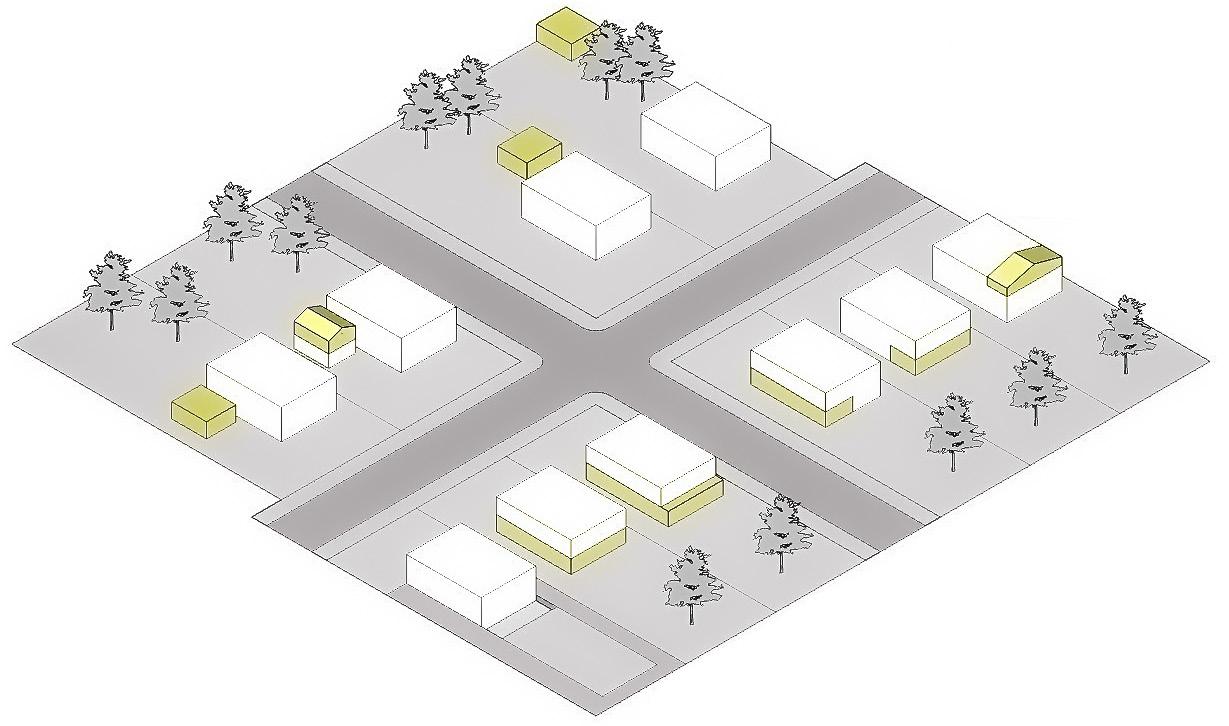
ADU (attic conversion)
ADU (partial garage conversion)
ADU (basement conversion with extended rear)
ADU (basement depressed for additional height)
Figure 13. Adapted from AARP, Accessory Dwelling Units A Step by Step Guide to Design and Development, 2019
The City of Raleigh’s Accessory Dwelling Unit (ADU) Fast Track program streamlines the development review process for constructing detached ADUs. An ADU is a small, selfcontained dwelling that is located on the same parcel as a primary dwelling. ADUs may be detached, attached, or internal to a primary dwelling (see Figure 13). The program includes an online gallery of detached ADU plans that have been determined to be compliant with building codes.20 The gallery currently contains 11 ADU plans that start as small as 300 square feet, offers one- and two-story dwellings, and includes designs that are ADAaccessible. Lot owners can view the gallery and purchase the plans at a fee far below the typical design cost. Owners are still required to prepare and submit a site plan and apply for and receive all applicable permits with associated fees, but the program makes constructing an ADU a more accessible process.21 To learn more about Raleigh’s ADU Fast Track program and view the ADU gallery, visit https://raleighnc.gov/permits/services/building-accessorydwelling-unit-adu
The County, in collaboration with the Town, could create a similar fast track program for development of small dwellings on small lots that have the potential for residential infill development. The fast-track program could be developed in partnership with the County, UMD’s School of Architecture, Planning & Preservation, and UMD’s PALS program through implementing Strategies 2.1 and 2.2.
20 “Raleigh’s ADU Fast Track Gallery Website,” City of Raleigh, accessed December 11, 2023. https://experience.arcgis.com/ experience/db482b2fdbc34ebeb174438a091097d8.
21 City of Raleigh. “Raleigh ADU Fast Track Gallery.” Accessed December 11, 2023. https://experience.arcgis.com/experience/ db482b2fdbc34ebeb174438a091097d8
Provide technical support for vacant lot owners to understand what is allowable
Develop a resource that provides practical ideas for development/uses of vacant lots and implementation resources.
Focus Area: Privately owned vacant lots that are challenging to develop (i.e., have slopes that are 15 percent or greater, overlap wetlands, and/or do not meet the Zoning Ordinance’s minimum lot area; see Map 16).
The resource would provide guidance on how to overcome hurdles with small lots; potential use ideas; and resources to help implement ideas such as County expertise and funding. Potential use ideas could include, but are not limited to, the following:
• Side yard expansion of adjacent lot owner—side yards could include maintained open space, gardens, a driveway, and/or small structures such as a garage, garden shed, or gazebo
• Gathering area, mini-park, or garden for a nearby church or community organization/group
• Park, play space, or small playground for public use or a nearby church or daycare
• Picnic area with picnic tables and/or a small open-air shelter structure
• Performance space (small stage or amphitheater)
• Public art installation or a sculpture garden
• Seasonal or pop-up markets for locally grown food and/or artisans
• Community garden or food forest (diverse planting of edible plants)
• Outdoor classrooms for a nearby school, church, or community organization/group
• Neighborhood pathway that provides a pedestrian link between streets
• Stormwater infrastructure (bioswale, rain gardens, rain barrels)
The M-NCPPC Prince George’s County Planning Department’s PAMC program could also be utilized as a resource to develop and/or fund development of a handbook. The Planning Department’s Placemaking Section could be used to evaluate or showcase ideas in the handbook through temporary activations on vacant lots. Placemaking projects have included events and initiatives to test for uses and encourage activity in public spaces; “branding” places through public art, events, and signage; and redesigning streets and sidewalks for better pedestrian and cyclist experiences.
The Prince George’s Department of Permitting, Inspection, and Enforcement (DPIE) will be a key stakeholder in the development of this type of handbook.
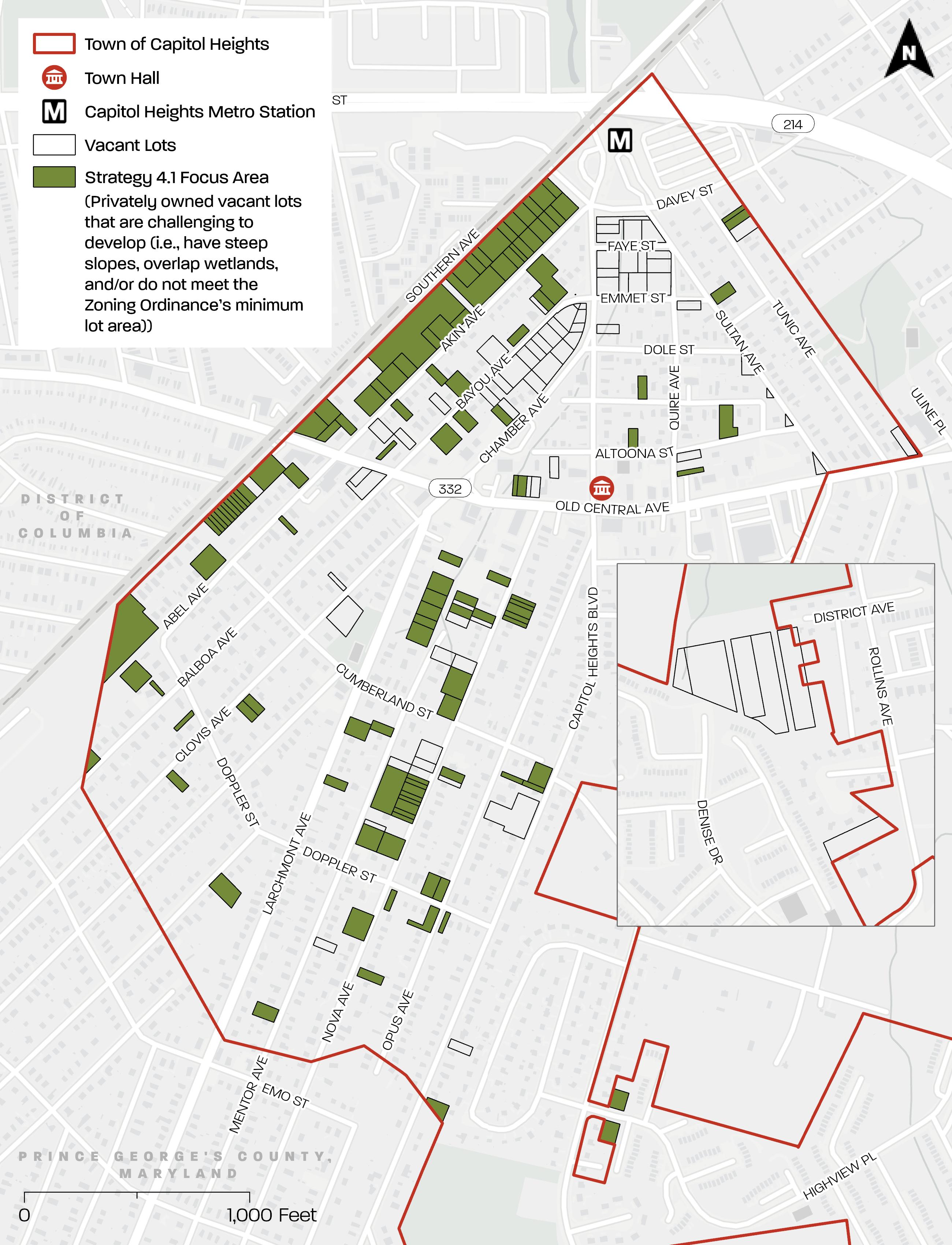
Map 16 . Strategy 4 1 Focus Area
Source: PGAtlas com ; Prince George’s County Zoning Ordinance
Map 17 . Strategy 4 . 2 Focus Area
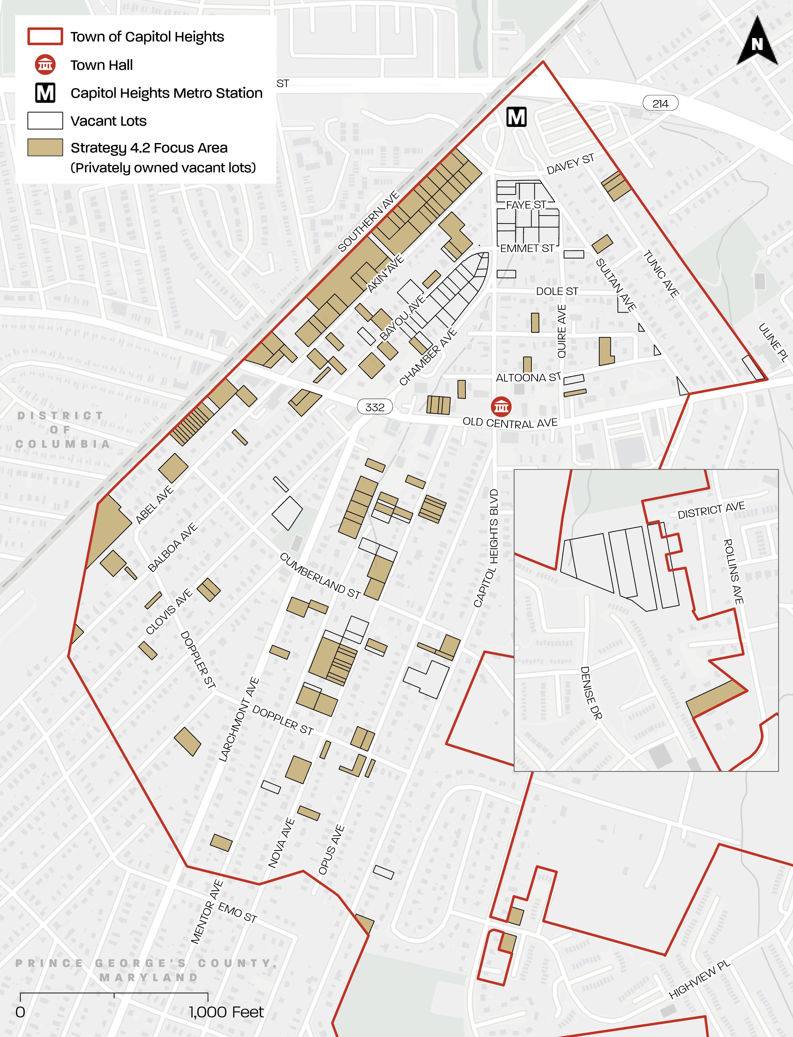
Source: PGAtlas com ; https://sdat dat maryland gov/RealProperty/Pages/default aspx
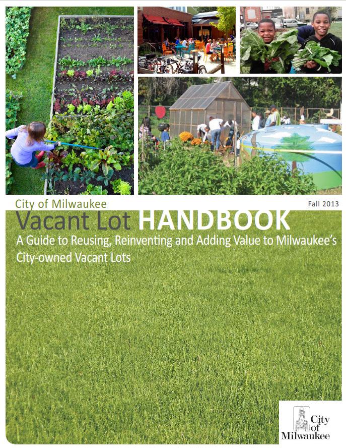
City of Milwaukee, Wisconsin–Vacant Lot Handbook
The City of Milwaukee’s 2013 Vacant Lot Handbook, A Guide to Reusing, Reinventing and Adding Value to Milwaukee’s Cityowned Vacant Lots provides practical ideas to residents and community groups interested in turning city-owned vacant lots into community assets (see Figure 14). Milwaukee provides opportunities for residents to buy or use through a temporary use permit, city-owned vacant lots. The handbook includes creative reuse strategies for vacant land, some of which can be implemented easily with modest resources and minimal planning, whereas others require resources, support, and time to develop. Potential ideas include neighborhood amenities and green space, urban agriculture and community gardens, active multiuse spaces, environmental strategies, and residential and commercial development. The handbook also includes sections with answers to frequently asked questions, plant recommendations, and “Getting Started” resources. To view Milwaukee’s Vacant Lot Handbook, visit https://city.milwaukee.gov/ ImageLibrary/Groups/cityDCD/planning/pdfs/ VacantLotHandbook.pdf
Although Milwaukee’s Vacant Lot Handbook focuses on ideas for city-owned vacant lots, a similar type of handbook could be created for privately owned vacant lots within the Town of Capitol Heights through implementing Strategy 4.1.
Engage vacant lot owners one-on-one to provide site-specific guidance.
Focus Area: Privately owned vacant lots (see Map 17).
The Town, in collaboration with the County, could host virtual or in-person one-on-one meetings and/or local open houses where vacant lot owners can discuss lot-specific ideas and challenges and receive lot-specific implementation guidance from County and/or Town professionals with expertise in zoning and development regulations.
Recommendation 4 Considerations:
Employing the handbook and meeting with County and/or Town staff will require the interest of private vacant lot owners in developing/using their vacant lots.
https://city milwaukee gov/ImageLibrary/Groups/ cityDCD/planning/pdfs/VacantLotHandbook pdf
Consider incorporating some publicly owned lots into the broader open space network or transferring them to a private owner
Establish a Side Lot Program for Town- or County-owned lots
Focus Area: Publicly owned vacant lots not adjacent to the Capitol Heights Metro Station (see Map 18).
Publicly owned vacant lots may be unattractive to potential buyers/developers and/or the value of these lots may be low. To an adjacent owner, however, these lots may be valuable real estate. An adjacent lot may allow an adjacent owner to expand their yard. In other cases, incorporating an adjacent vacant lot may create a developable site.
The Town would identify non-developable, non-contiguous, publicly owned lots. These lots would be made available to adjacent lot owners through one of the following:
• Lots would be made available for sale at a nominal fee (under $200) to an adjacent lot owner; or
• Lots would be made available to an adjacent lot owner through a “mowto-own” program. This type of program would allow prospective owners to take immediate ownership of a publicly owned lot for a nominal fee after the prospective owner completes regular maintenance of the lot for a defined period, such as 24 months.
To qualify for participation in these programs, the adjacent lot must be occupied, and the prospective owner must meet a set of criteria defined by the County or Town such as non-delinquent property tax payments.
Considerations:
• The program would reduce maintenance costs for the County and Town.
• Implementation of this program would require that the County and Town agree to contribute their small vacant lots to the program and to develop a set of qualifying criteria for adjacent lot owner participation in the program.
• Implementation of a mow-to-own program would require an administrative and enforcement process to review program applications and ensure prospective owners are meeting maintenance requirements. Prospective owners could be required to document maintenance.
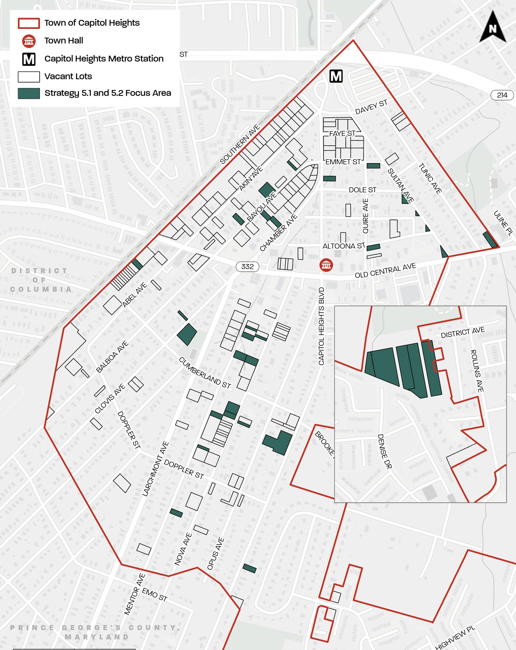
Map 18 . Strategy 5 . 1 and 5 . 2 Focus Area
Source: PGAtlas com ; https://sdat . dat . maryland gov/RealProperty/Pages/default . aspx


Figure 15 City of Rockford’s “Mow or Improve to Own: City Owned Vacant Lot Program” Brochure Accessed December 11, 2023 . https://www. rockfordil.gov/237/Mow-to-OwnImprove-Program

Several cities throughout the country have implemented mow-to-own programs where residents can acquire lots if they put forth the effort to maintain them. Table 1 summarizes examples of prospective owner eligibility and maintenance requirements of a few currently active mow-to-own programs. The details, including application process and fees for participation in these programs, vary. Although not all these programs focus on publicly owned vacant lots, the program’s eligibility and maintenance requirements could inform a mow-to-own program in the Town of Capitol Heights.
PROGRAM LOCATION TYPES OF PROPERTIES
Rockford, Illinois22
City-owned vacant residential lots
PROSPECTIVE OWNER REQUIRED TO BE ADJACENT LOT OWNER?
Yes, but 501(c) (3) nonprofit organizations are also eligible
PROSPECTIVE OWNER ELIGIBILITY
Must own and occupy their residence
Does not have buyer delinquent taxes in the county within the last five years
• Does not have a history of lot maintenance, nuisance, building and zoning code violations within the last five years
• Does not have any delinquent city utility accounts within the last five years
MAINTENANCE REQUIREMENTS
Mowing and trimming once every two weeks
Raking leaves
Shoveling snow
• Picking up trash
Maintenance time period: two years
TO LEARN MORE ABOUT THE PROGRAM, VISIT:
https://www rockfordil gov/237/ Mow-to-OwnImprove-Program
The program also has an easyto-digest public brochure (see Figure 15)
Beatrice, Nebraska23
New Orleans, Louisiana24
City-owned vacant residential lots
No, but program gives priority to adjacent lot owners
Adjudicated (extremely tax delinquent) vacant lot
(Note: Louisiana state law authorizes City-Parish to sell adjudicated properties)
Yes
• Does not owe delinquent real estate or personal property taxes;
• Has had no lot maintenance, nuisance, building, and/or zoning code violations within the previous 36 months; and Has kept any/all accounts with the City of Beatrice Board of Public Works in good standing
• Has good standing with the city
Does not have any open code violation cases
Is up to date on property taxes
• Mowing
Snow removal
• Necessary weed management or tree trimming
Maintenance time period: dependent on the lot’s assigned value
https://www beatrice ne gov/ communitydevelopment/ page/mow-ownprogram
• Mowing Maintenance time period: one year
https://nola gov/next/codeenforcement/ programs/mowto-own-program/
22 “Mow to Own & Improve Program,” Community and Economic Development, City of Rockford, accessed December 11, 2023, https://www.rockfordil.gov/237/Mow-to-Own-Improve-Program
23 “Mow-To-Own Program,” Community Development, Beatrice, accessed December 11, 2023, https://www.beatrice.ne.gov/community-development/page/mow-own-program
24 “Mow to Own Program,” Division of Code Enforcement, City of New Orleans, last modified August 1, 2023, accessed December 11, 2023, https://nola.gov/next/code-enforcement/programs/mow-to-own-program/
Create new green spaces and publicly accessible open spaces.
Focus Area: Publicly owned vacant lots not adjacent to the Capitol Heights Metro Station (see Map 18).
Publicly owned vacant lots could be incorporated into a broader green space and publicly accessible open space network. This strategy would help enhance the environmental and public value of public land.
Open space could include, but is not limited to, public plazas and seating areas, “pocket” or mini parks, protected forested areas, and stormwater management green infrastructure. Each open space type will require a different maintenance requirements once implemented. Community engagement should be integral to the process of identifying solutions and designing open spaces.
Implementation of this strategy will require the County and Town to agree to contribute their vacant lots to the open space network. The County or Town could secure grants or other funding resources to plan, design, and create these open spaces. Partnerships with interested local community organizations/groups and/or volunteer groups could be utilized for developing and maintaining these open spaces.
Grant funding could be obtained from multiple sources. Examples of potential funding partnerships and grant opportunities are summarized in Table 2.
Pocket parks are typically small urban open spaces used for passive recreation. These mini parks are often a single space designed for casual use and serve people working nearby. They are frequently located in places with a high volume of pedestrian traffic and visibility. Often owned and or maintained by a property association, or neighborhood group, these small spaces create an oasis in urbanized areas. 25
25 The Maryland-National Capital Park and Planning Commission Department of Parks and Recreation, Prince George’s County, Formula 2040: Functional Master Plan for Parks, Recreation and Open Space (2013), https://www.pgparks.com/wp-content/ uploads/2023/03/2040-Functional-Master-Plan.pdf
POTENTIAL FUNDING PARTNER
Project for Public Spaces (and coordination with Prince George’s County Planning Department, Placemaking Section)
Maryland Department of Natural Resources/ National Park Service
POTENTIAL GRANT OPPORTUNITY DESCRIPTION
Placemaking Grants
• Works directly with local stakeholders to transform public spaces or co-create new ones
• Provides direct funding for physical improvements and programming as well as technical assistance and capacity-building opportunities
Land and Water Conservation Fund Grant
• Provides up to 50 percent matching fund assistance for projects that are in direct support of public outdoor recreation uses of related properties and/or facilities
Provides funding for:
» Land acquisition for the use of public outdoor recreation
» New outdoor recreation amenities/facilities
» Renovations/improvements of existing outdoor recreation facilities
Maryland Department of Natural Resources
Program Open Space - Local
Maryland Department of Natural Resources Community Parks & Playgrounds Program
Provides financial and technical assistance to local subdivisions for the planning, acquisition, and/or development of recreation land or open space areas
Provides funding to restore existing and creating new park and green space systems in Maryland’s cities and Towns
• Provides flexible grants to local governments to respond to the unmet need for assistance to:
» Rehabilitate, expand, or improve existing parks
» Create new parks
» Develop environmentally oriented parks and recreation projects
» Purchase and install playground equipment in older neighborhoods and intensely developed areas
• Local governments
• Nonprofits
https://www.pps.org/community-placemaking-grants
https://www.pps. org/communityplacemakinggrants
U S Department of Agriculture Urban Agriculture and Innovative Production Grants
• Initiates or expands efforts of farmers, gardeners, citizens, government officials, schools, and other stakeholders in urban areas and suburbs
Supports two types of projects:
» Planning projects that may accomplish one or any number of needs such as food access; education; business and start-up costs for new farmers; and development of policies related to zoning and other needs of urban and urban agroforestry production
» Implementation projects that will improve local food access and collaborate with partner organizations and may support infrastructure needs; emerging technologies; educational endeavors; and urban farming policy implementation
• Municipalities Counties https://dnr. maryland.gov/ land/Pages/LWCFGrants.aspx
Municipalities Counties
https://dnr.maryland.gov/land/Pages/LWCF-Grants.aspx
https://dnr.maryland.gov/land/Pages/ProgramOpenSpace/cpp.aspx
Incorporated municipalities https://dnr.maryland.gov/land/Pages/ProgramOpenSpace/cpp.aspx
• Local governments
• Nonprofits Schools
https://www.usda. gov/topics/urban/ grants#types
The origins of the Chicago Resilient Corridors project date to 2013 when a severe rainstorm caused 2,500 “water in basement” and 800 “water on street” complaints in addition to damaged businesses and flooded train stations and bus stops. In response, the city used grant funding to develop stormwater infrastructure on ten city-owned vacant sites located on three transitional commercial corridors in floodaffected neighborhoods. The project utilized data to identify optimal locations for the stormwater infrastructure. The sites were designed to include green infrastructure strategies such as permeable pavements, rain gardens, and bioswales that accept stormwater from streets, alleys, and adjacent lots. Community engagement generated programming for each site, which included passive gardens, active recreation areas, and public plazas. Construction was completed in fall 2018. As of 2018, stewards were identified (such as local business owners, the Chicago Botanic Garden, and the YMCA) to lease and maintain the specialized landscapes. A “Resilient Corridors Project Manual,”26 was developed as part of the project. The Manual provides stewards with guidance to facilitate longterm success since green infrastructure treatments have more technical requirements.27
26 “Chicago Resilient Corridors,” American Society of Landscape Architects, Illinois Chapter, accessed December 11, 2023, https://il-asla. org/award/chicago-resilient-corridors/#:~:text=The%20Chicago%20 Resilient%20Corridors%20project%20has%20served%20as%20a%20 springboard,to%20strengthen%20the%20public%20realm
27 Chicago Department of Planning & Development, Resilient Corridors (2018), https://www.metroplanning.org/uploads/cms/ documents/michael_berkshire_resilient_corridors.pdf.
16. Chicago Resilient Corridors Project - Implementation and Examples of Completed Sites CREDIT: AECOM
The Town’s early actions should focus on achieving the following:
• Enhancement of lot aesthetics
• Reduction of fines and citations issued to lot owners
• Reduction of Town staff time and resources associated with the code enforcement process
• Reduction or elimination of potential risks (for example, falling dead trees) or nuisances (for example, undesired wildlife) to neighboring property
• Determent of illegal dumping and litter
• Attraction of development interest The following strategies, and priority steps for these strategies, should be implemented to advance these short-term goals:
Strategy 1.1: Implement a Vacant Lot Education Campaign.
• Update the Town’s website with a “Vacant Lot” section as part of the Vacant Lot Education Campaign.
• Develop and distribute a code enforcement newsletter to lot owners as part of the Vacant Lot Education Campaign.
Strategy 1.2: Identify multijurisdictional solutions to address illegal dumping along major corridors.
• Contact and schedule a meeting with the Washington, DC Department of Public Works Solid Waste Education and Enforcement Program to discuss multijurisdictional solutions to address illegal dumping.
Strategy 1.3: Pursue funding strategies and County resources to clean/safeguard vacant lots.
• Identify and contact community organizations/groups who would be interested in performing cleanups
through the County DoE Neighborhood Cleanup Program. Community organizations/groups could include churches, scout groups, school groups looking for community service credits, et cetera.
• Identify and contact private lot owners who would be receptive to a community organization/group cleanup of their vacant lot.
Strategy 2.1: Initiate a request for proposal for redeveloping eligible vacant lots near the Capitol Heights Metro Station.
• Identify and contact appropriate participants from the development community to participate in a focus group discussion to understand opportunities for the LTO-zoned vacant lots and Central Avenue-Blue/Silver Line Sector Plan and Sectional Map Amendment currently underway.
Strategy 4.1: Develop a resource that provides practical ideas for development/uses of vacant lots and implementation resources.
• Identify a scope and draft an outline for the handbook. The scope and outline could be used as a basis for conversations with vacant lot owners to provide site-specific guidance (as in Strategy 4.2) or discuss the process for lot consolidation or side yard extension.
• Apply to the Prince George’s County PAMC Program for the development of a handbook.
• The Prince George’s Department of Permitting, Inspection, and Enforcement will be a key stakeholder in the development of this type of handbook.
Strategies should be implemented as resources (for example, staff time, funding, grant opportunities) become available.
The Town will be the initiator for all strategies. Table 3 provides a summary of potential partners to help the Town implement these strategies.
Recommendation 1: Dedicate or pursue public-private partnerships to help clean up and maintain vacant land.
Strategy 1.1
Evaluate Beautification Initiatives or Create a New Program to Support Clean-up of Vacant Lots
Strategy 1.2
Identify multijurisdictional solutions to address illegal dumping along major corridors
Strategy 1.3
Pursue funding strategies and County resources to clean/safeguard vacant lots
Department of the Environment
Recommendation 2: Leverage contiguous vacant lots to support future TOD and residential infill opportunity.
Strategy 2.1
Initiate a request for proposal for redeveloping eligible vacant lots near the Capitol Heights Metro Station
Strategy 2.2
Establish common development interest among two or more lot owners to combine/sell contiguous vacant lots via a broker for residential infill
Recommendation 3: Adopt a small lot ordinance and develop a small house pattern book to streamline small lot residential infill development.
Strategy 3.1
Develop and adopt a County small lot ordinance
Strategy 3.2
Develop a pattern book of smaller dwellings and smalllot infill development guidelines .
Recommendation 4: Provide technical support for vacant lot owners to understand what is allowable, and how they can overcome hurdles.
Strategy 4.1
Develop a resource that provides practical ideas for development/uses of vacant lots and implementation resources
Strategy 4.2
Engage vacant lot owners one-on-one to provide site-specific guidance
Prince George’s District Council; M-NCPPC Planning Department
M-NCPPC Planning Department
M-NCPPC Planning Department (Community Planning Division’s Placemaking Section)
Recommendation 5: Consider incorporating some publicly owned lots into the broader open space network or transferring them to a private owner.
Strategy 5.1
Establish a Side Lot Program for Town- or County-owned lots
Strategy 5.2
Create new green spaces and publicly accessible open spaces
Prince George’s District Council; M-NCPPC Planning Department
Town of Capitol Heights, M-NCPPC
PRIVATE VACANT LOT OWNERS
COMMUNITY ORGANIZATIONS/GROUPS
GROUPS
Recommendation 1: Dedicate or pursue public-private partnerships to help clean up and maintain vacant land.
District of Columbia
Maintenance/landscaping company
Recommendation 2: Leverage contiguous vacant lots to support future TOD and residential infill opportunity.
Local residential broker
Recommendation 3: Adopt a County small lot ordinance and develop a small house pattern book to streamline small lot residential infill development.
Universities; PAMC Program
Recommendation 4: Provide technical support for vacant lot owners to understand what is allowable, and how they can overcome hurdles.
Universities; PAMC Program
Recommendation 5: Consider incorporating some publicly owned lots into the broader open space network or transferring them to a private owner.
At the date of publication, Table 4 includes the 194 lots in the Vacant Lot Inventory. The lot address, account, and zone information are based on Prince George’s County GIS data and the Land Data File (LDF) table consisting of a portion of SDAT’s real property master file for Prince George’s County. Note that some vacant lots have addresses with street numbers and some do not. Street numbers are only available for vacant lots where there once was a dwelling.
This lot is partially vacant and partially not vacant; there is a single-family detached dwelling at 18 Akin Avenue. This lot has more than one owner/tax account number and is composed of more than one lot. The lot(s) associated with one of these owners/tax account numbers is vacant. The lot(s) associated with the other owner/tax account number is not vacant.
This lot fronts both Akin Avenue and Bayou Avenue and therefore, has addresses on both streets.
This lot is partially vacant and partially not vacant; there is a single-family detached dwelling at 48 Bayou Avenue. This lot has more than one owner/tax account number and is composed of more than one lot. The lot(s) associated with one of these owners/ tax account numbers is vacant. The lot(s) associated with the other owner/tax account number is not vacant.
This lot is partially vacant and partially not vacant; there is a single-family detached dwelling at 11 Bayou Avenue. This lot has more than one owner/tax account number and is composed of more than one lot. The lot(s) associated with one of these owners/tax account numbers is vacant. The lot(s) associated with the other owner/tax account number is not vacant.
American Society of Landscape Architects, Illinois Chapter. “Chicago Resilient Corridors .” Accessed December 11, 2023 https://il-asla org/award/chicago-resilient-corridors/#:~:text=The%20 Chicago%20Resilient%20Corridors%20project%20has%20served%20as%20a%20 springboard,to%20strengthen%20the%20public%20realm .
Beatrice “Mow-To-Own Program ” Community Development Accessed December 11, 2023 https:// www beatrice .ne .gov/community-development/page/mow-own-program .
“Capitol Heights and Greater Capitol Heights (75A-056),” Historic Communities Survey, EHT Traceries, Inc , 2009 Historic Sites and Districts Plan Historic Resource and Community Survey Update Database (mncppcapps org)
Chicago Department of Planning & Development . Resilient Corridors . 2018 . https://www . metroplanning org/uploads/cms/documents/michael_berkshire_resilient_corridors pdf
City of Milwaukee Vacant Lot Handbook . 2013 . https://city .milwaukee .gov/ImageLibrary/Groups/ cityDCD/planning/pdfs/VacantLotHandbook pdf
City of New Orleans “Mow to Own Program ” Division of Code Enforcement Last modified August 1, 2023 Accessed December 11, 2023 https://nola gov/next/code-enforcement/programs/mow-toown-program/
City of Raleigh “Building an Accessory Dwelling Unit (ADU) ” Accessed December 11, 2023 https:// raleighnc .gov/permits/services/building-accessory-dwelling-unit-adu .
City of Rockford “Mow to Own & Improve Program ” Community and Economic Development Accessed December 11, 2023 https://www .rockfordil gov/237/Mow-to-Own-Improve-Program .
Clean Water Partnership Frequently Asked Questions . n d https://e58070 .p3cdn1 secureserver.net/ wp-content/uploads/2017/12/CWP_FAQ_120817 .pdf .
District of Columbia “Solid Waste Education and Enforcement – SWEEP ” Department of Public Works Accessed December 11, 2023 https://dpw dc gov/service/solid-waste-education-andenforcement-sweep
Lincoln Institute of Land Policy “Philadelphia LandCare ” Lincoln Institute of Land Policy Accessed December 11, 2023 https://phsonline org/programs/transforming-vacant-land
Loesch, Maggie “Greening Vacant Lots: Low Cost, Big Effect in Philly ” Shelterforce, November 13, 2018 . https://shelterforce org/2018/11/13/greening-vacant-lots-low-cost-big-effect-in-philly/ .
Maryland Department of Commerce “Enterprise Zone Tax Credit (EZ) ” Accessed December 11, 2023 . https://commerce .maryland gov/fund/programs-for-businesses/enterprise-zone-tax-credit
National Association of Home Builders Diversifying Housing Options with Smaller Lots and Smaller Homes . 2019 https://www nahb .org/-/media/NAHB/advocacy/docs/top-priorities/housingaffordability/nahb-2019-small-homes-research-report pdf
Pennsylvania Horticultural Society “Transforming Vacant Land .” Accessed December 11, 2023 https://phsonline org/programs/transforming-vacant-land
Prince George’s County, MD “Alternative Compliance .” Accessed December 11, 2023 https://www . princegeorgescountymd gov/departments-offices/environment/stormwater-management/raincheck-rebate-program/alternative-compliance
Prince George’s County, MD Housing Opportunity for All . 2019 https://pgccouncil .us/ DocumentCenter/View/4043/Housing-Opportunity-for-All_-REPORT
Prince George’s County, MD “Volunteer Opportunities .” Accessed December 11, 2023 https:// www princegeorgescountymd gov/departments-offices/environment/sustainability/get-involved/ volunteer-opportunities
Prince George’s County, MD Zoning Ordinance, Subdivision Regulations, & Landscape Manual Accessed October 2, 2022 . https://online encodeplus .com/regs/princegeorgescounty-md/docviewer aspx?tocid=002#secid--1
“Raleigh ADU Fast Track Gallery,” City of Raleigh, accessed December 11, 2023, https://experience arcgis com/experience/db482b2fdbc34ebeb174438a091097d8
The Clean Water Partnership . “Prince George’s County Clean Water Partnership ” Accessed December 11, 2023 https://thecleanwaterpartnership com/
The Maryland-National Capital Park and Planning Commission Department of Parks and Recreation, Prince George’s County Formula 2040: Functional Master Plan for Parks, Recreation and Open Space 2013 https://www pgparks .com/wp-content/uploads/2023/03/2040-Functional-MasterPlan .pdf .
The Town of Capitol Heights, “Ordinance 2012-006,” (2013) .
The Wharton School, The University of Pennsylvania “Wharton Research Shows Revitalizing Vacant Lots Pays Dividends .” Analytics at Wharton News Last modified February 6, 2023 . Accessed December 11, 2023 https://analytics wharton upenn edu/research/impact-analytics/ landcare-pays-dividends/
The White House Opportunity and Revitalization Council White House Opportunity and Revitalization Council: Best Practices Report to the President 2020 https://opportunityzones hud gov/sites/opportunityzones .hud .gov/files/documents/OZ_Best_Practices_Report pdf .
United States Census Bureau “Capitol Heights Town, Maryland .” Accessed December 11, 2023 . https://data census gov/profile/Capitol_Heights_Town,_Maryland?g=160XX00US2413000
This project was funded and managed by the Planning Assistance to Municipalities and Communities (PAMC) program, Prince George’s County Planning Department.
Lakisha Hull, AICP LEED AP BD+C
James Hunt, MPA
Tony Felts, AICP
Frederick Stachura, J.D.
Daniel Sams
Karen Mierow, AICP
Zachary Banham
Tamika Henderson
Planning Director
Deputy Director of Operations
Deputy Director of Administration
Supervisor, Neighborhood Revitalization Section
Planner IV, PAMC Program Manager
Planner III, Project Manager
Senior GIS Specialist, Placemaking Section
Administrative Assistant III
Countywide Planning Division
Thomas Burke
Supervisor, Environmental Planning Section
Paul Patnode
Principal GIS Specialist, Geographic Information Services Section
Management Services Division
Daniel Hartman
Ryan Craun
Tamu Wright
Corianne Setzer
M’balu Abdullah
DeWayne Williamns
Abi Birratu
Project development by:
*Wendy Irminger
*Zachary W. Luckin
*Former employee
Administrative Manager
Senior Visual Media, and Imaging Specialist
Editor, Publications Specialist
Designer, Publications Specialist
Senior IT Support Specialist/Web Manager
Clerical/Inventory Operations Supervisor
Senior Clerical/Inventory Operations Assistant
Planner III, Neighborhood Revitalization Section, Community Planning Division
Planner I, Neighborhood Revitalization Section, Community Planning Division
Joyce Tsepas, AICP
Lauren Tuttle, AICP
Project Director/Urban Planning Lead
Project Manager/Associate
Katy Adubi Associate
Cristina Dávila Gonzalez
Theo M. Pollack, AICP
Claire Sale, AICP
Colleen Willger, AICP
Urban Planner
Senior Urban Planner
Associate Principal
Director of Urban Strategy
Sarah Woodworth Managing Member
Mayor and Town Council, Town of Capitol Heights
*Beverly Habada Town Manager
Dezirae Montgomery Property Standards Authority, Neighborhood Services Department

* Former employee