
7 minute read
MARIA PAULA VEGA GUALDRÓN

from PORTFOLIO

Architect Education
Architecture degree
Advertisement
2023
Pontificia Universidad Javeriana
Senior Highschool
2017
Colegio Agustiniano Ciudad Salitre
Work Experience
Contact
mariapvegag@gmail.com
(+57) 3013370390
Link portfolio https://issuu.com/mpvg
Mentions
“Orden al mérito académico Javeriano”
2023
Academic award
Exhibition at Biennale di Venezia
2020
Project: Wich city for wich future?- Chapinero
Pontificia Universidad Javeriana
Politécnico di Torino
Postulation - Honorable mention of the degree Work
December 2022
Project: “Ruta de reparación colectiva para la paz y la memoria en la hoya del río Suarez.”
Honorable Mention - Velodrome contest in Bogotá
December 2021
A+3 Architecture
CivilTeknia S.A.S
May - August 2022
Participation on the public space and landscaping manual for the “Hacienda Cauchitos” project located in the city of Ibague.
Design of public space plans, construction of technical sheets, build-up details and support in the post-production area.
MRV Architects
January - July 2022
Design and construction
Drawing and modeling residential projects, furniture design, production of 3D images and support at the graphic design area.
Velodrome contest in Bogotá
December 2021
A+3 Architecture
With Arq. Alberto Aranda and Arq. Nicolás Monje.
Collective
Colombian Society of Architects
2020 - Ongoing
Active member of the student group of the Colombian society of architects (CESCA).
Languages
English B2
Certified by the TOEIC test.
Italian B1
Course at the Istituto Italiano di cultura
Spanish Native
Software Skills
AutoCad
Archicad Revit
Rhinoceros
SketchUp
Photoshop InDesign Illustrator Lightroom
Adobe Bridge
3ds Max
Enscape
Lumion
V-ray
ArcGis Global Mapper Excel M. Project
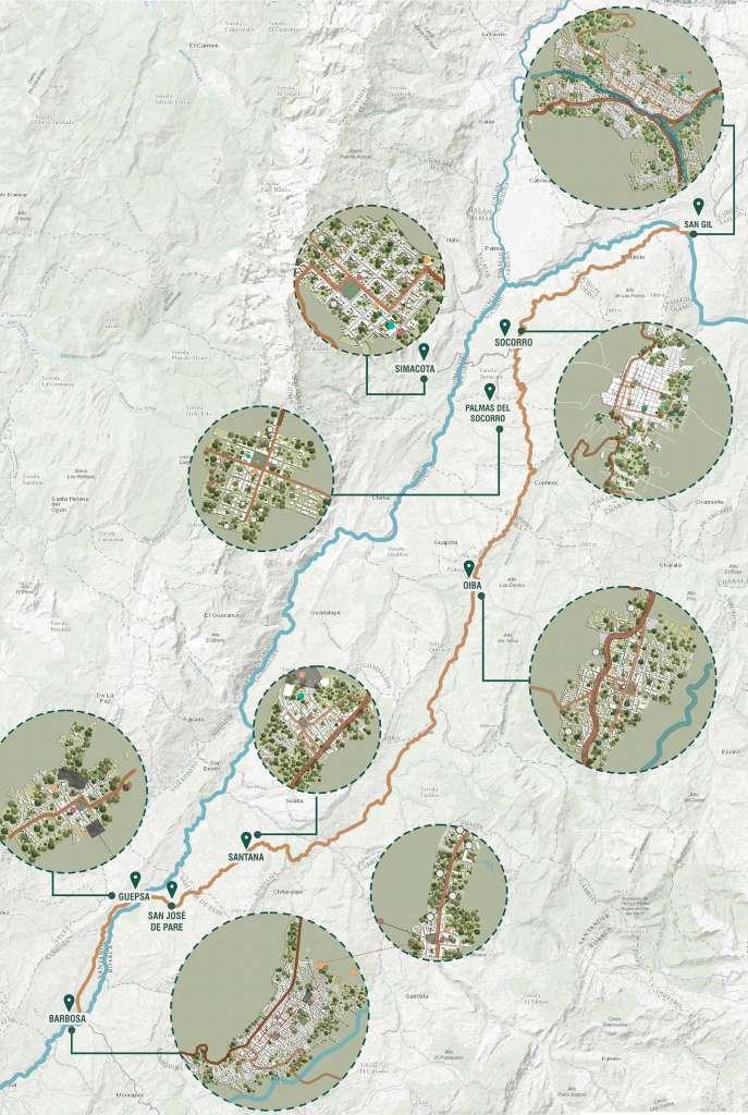
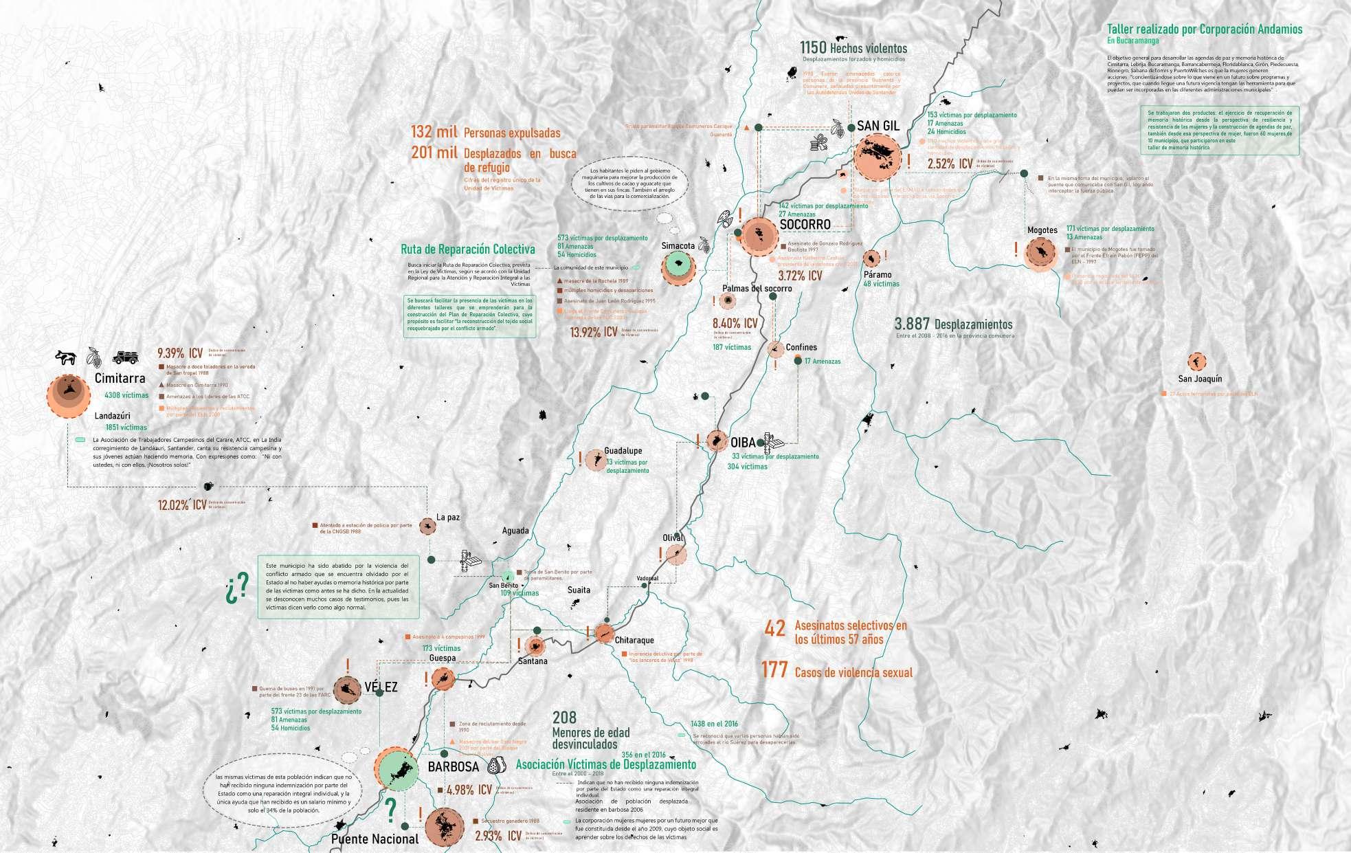
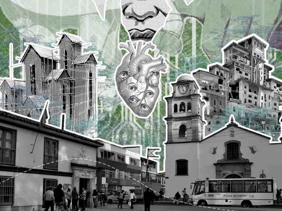
Collective Reparation Path For Peace And Memory
Located in Santander, Colombia.
December 2022
The senior project proposes an alternative repairing route for peace and memory in the municipalities along the Suárez River, through commemorative public spaces that face the invisibilization of the multiple conflicts that have struck the territory in recent decades.
Understanding the silent violence that transformed the territory is fundamental to the analysis and what leads to a first territorial proposal, the “collective reparation path for peace and memory.” Based on the above, a reflection is generated around the architecture of memory, how this can deal the tragedy of naturalizing the war and let see what happened in the territory.
The collective reparation path contributes to this whole process of recognition, significance and healing for the territory and its inhabitants. Strategic spaces are located that have been the basis for the connection of these sectors that make up the journey and provide spaces for recognition and peace.
Colombia has been the victim, for more than sixty years, of the internal conflict that has generated the increase in numbers in internal displacement, kidnappings, torture, abuses, among others; that have taken the lives of many inhabitants throughout the nation. Similarly, vulnerability, socio-territorial deterioration and lack of State presence and intervention in Colombia’s rural territories have created a habitat with precarious conditions for the population.
Ecorregión Suárez Chicamocha
It contains part of the departments of Santander and Boyacá
General Issue
Forced displacement by violence.
+4.9 Millon people internally and forced displaced +90Thousand missing people
Territory
The concept of “territory” is taken from the author Ovidio Delgado of his book“Space, territory and region: basic concepts for a national project” (Mahecha, O. 1998). Which, is understood as the scenario of social relations and the spatial capacity of different actors to create, appropriate, recreate, different territorialities in those spaces of power and dominion. It is a mutable, unbalanced mobile space; a changing geosocial reality that requires new forms of territorial organization.


They came from the south of Cesar, South of Bolívar, North of Santander and Northeast of Antioquia

From Magdalena Medio Santandereano and Barrancabermeja
Problem
The forgetfulness that has constrained almost to the oblivion of the violent acts that the territory of the river Suarez has suffered.
+27k victims of kidnapping

2.552 massacres between 1980 - 2014
23.161 mass murders
Longitudinal elevations
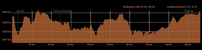
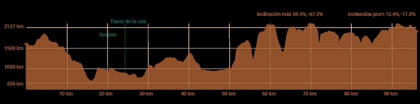
82% of the victims of the armed conflict were documented on the department.

1. Magdalena river
2. Suárez river
3. Chicamocha river
4. Fonce river
5. Mogoticos river
6. Boyacá Harbor
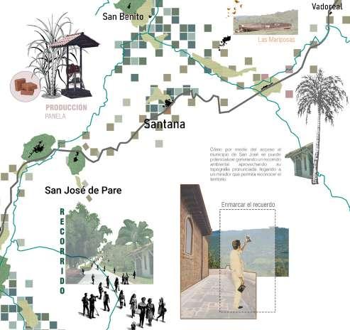
7. Fúquene reservoir Municipalities adjacent to the Suarez River
Water tributary diagram of the territory. Adapted from ArcGis. Own elaboration. esc 1:250.000

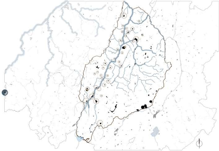
ANALYSIS Hydrographic Social
FARC
Frente 12
Frente 23
Frente 45
The ELN
The BCB
Frente Adonay Ardila Pinilla Frente Guillermo Antonio Vásquez Frente Capitán Palermo
Frente Comuneros Cacique Guanentá Frente Lanceros Vélez y Boyacá
Diagram of social conflicts in the territory. Adapted from Verdadabierta.com. Own elaboration. esc 1:250.000
Protected areas

Integrate Management District
Natural national park
Fauna and Flora Sanctuary
Extractive activities
Mining Titles
Oil Blocks
Undifferentiated erosion
Mass removal phenomenon
Landslides
Diagram of natural areas and extractive activities of the territory. Adapted from the Development of the stage of formulation of the Departmental Planning Plan-POD of Santander. Own elaboration.

Environmental Land-use
Institutional sustainable management for sustainable management of plantations
Natural forest intervened
Secondary natural forest
Transient annual cultivation
Permanent cultivation
Semi-permanent cultivation
Potters with natural pastures
Material Lands
Moorland vegetation
Xerophytic vegetation
Environmental Planning Plan of the territory. Adapted Adapted from the Development of the stage of formulation of the Departmental Planning Plan-POD of Santander. Own elaboration.
Diagnosis Plan Of The Territory
How through architecture can we face the invisibilization of violence?
How can we repair from places and memory?


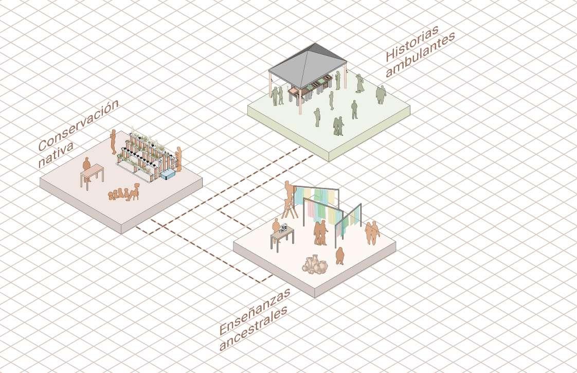
ACTIONS - REMEMBERING
This action is a sowing for the conservation of the native species of the territory, generating several forests as new lungs along the route.
This action seeks to plant a tree in the name of a person who died as a result of the conflicts that occurred in the territory.
ACTIONS OF - REMINISCE AND CONNECT
Conciliation trails allow to connect with the different actions along the route by means of natural paths.
The range of sensory experiences provides several spaces with different elements and materials that resemble what the victims lived.
This action seeks to give new meaning to those vestiges that are in disuse and allow them to re-articulate to the current and future network of dynamics.
Living shipwrecks arise from propitiating places that denote absence and other negative effects that left a mark on the territory.
Latent paths allow to connect with the different actions along the route generating spaces of permanence and encounter.

This action seeks to situate several informative devices that relate and make visible the conflicts that were experienced.

Linking Actions
Dialog channels generate spaces for re-connection and permanence in a natural environment.

Actions To Foresee
Walking stories emerges as an ephemeral transportable commercial support and spreading to the actions described above.
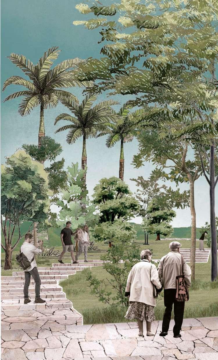
Spaces for reconnecting and remembering, are those that address the contemplation of memory.
Those passages of memory, are the viewpoints between the treetops, the mountain reliefs or near the river, that allow to contemplate the territory and the landscapes that compose it.
Native conservation are places dedicated to workshops that share the knowledge of the native species of the territory, their origin, conservation and production.
Ancestral teachings are places dedicated to workshops where you can share the knowledge you have of the different artisanal and/or productive techniques of the territory such as pottery vessels, fabrics in fique, the production of organic paper, among others.

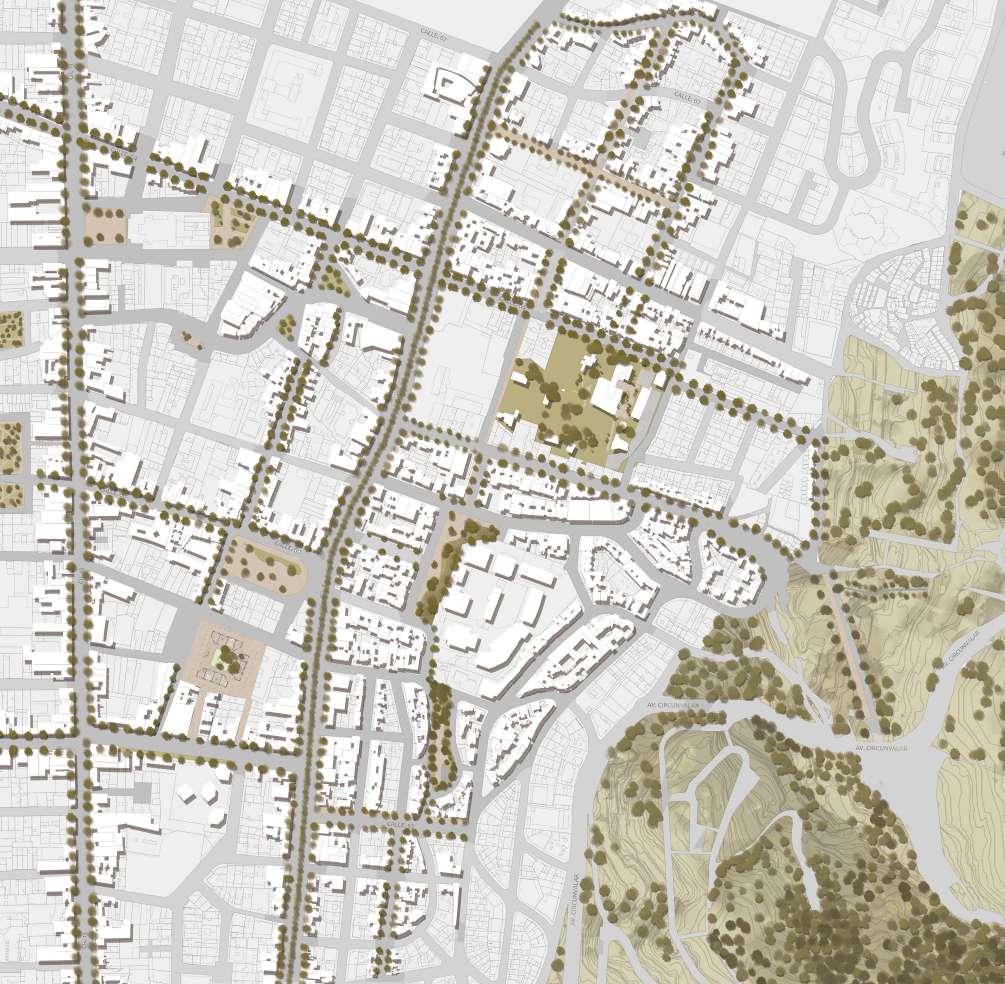
Urban Centers Project
May 2020
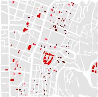
In this project, an urban intervention was carried out in the city of Bogotá, in the sector of Chapinero. Starting from an urban analysis of the sector and taking production as the basis of the physical spatial transformations that are evidenced, a series of phenomena were identified emerging and are the engine of those changes. Based on the above, a series of intervention strategies were generated at urban and neighborhood level, where a series of catalytic devices were generated that allow the creation of this new identified polyproduction and allows to potentialize new dynamics in the territory.

The sector has a pulviscular production condition, given its size limitation, that is colonizing the sector and is organized around emergent proximities that gravitate around the 7th avenue produced from internal metamorphosis originating a replica of identities of camouflaged landscapes, detected from the condition of use of space and induced by tendential dynamics, adapting to the new requirements of the city and managing to enhance integration with other uses.


Bogotá, Colombia North

Types of production


It seeks to strengthen the current production, to enable the interventions and transformations to achieve a greater character, becoming a center of business, scientific, technological and cultural activity of the city; providing new spaces for the arrival of new productions similar to the current ones, which generate a heterogeneous development and greater competitiveness.
Designing strategic spaces for the development of these new productions that, in the same way, favor the transmission of knowledge to the productive system, where it is necessary that the centers of scientific, technological and creative innovation, be located close to the companies. Likewise, the increase in buildability allows urban renewal projects to contribute to the re-urbanization of all streets in the sector and generate new green areas, equipment and housing that decisively improve the quality of life in the territory.
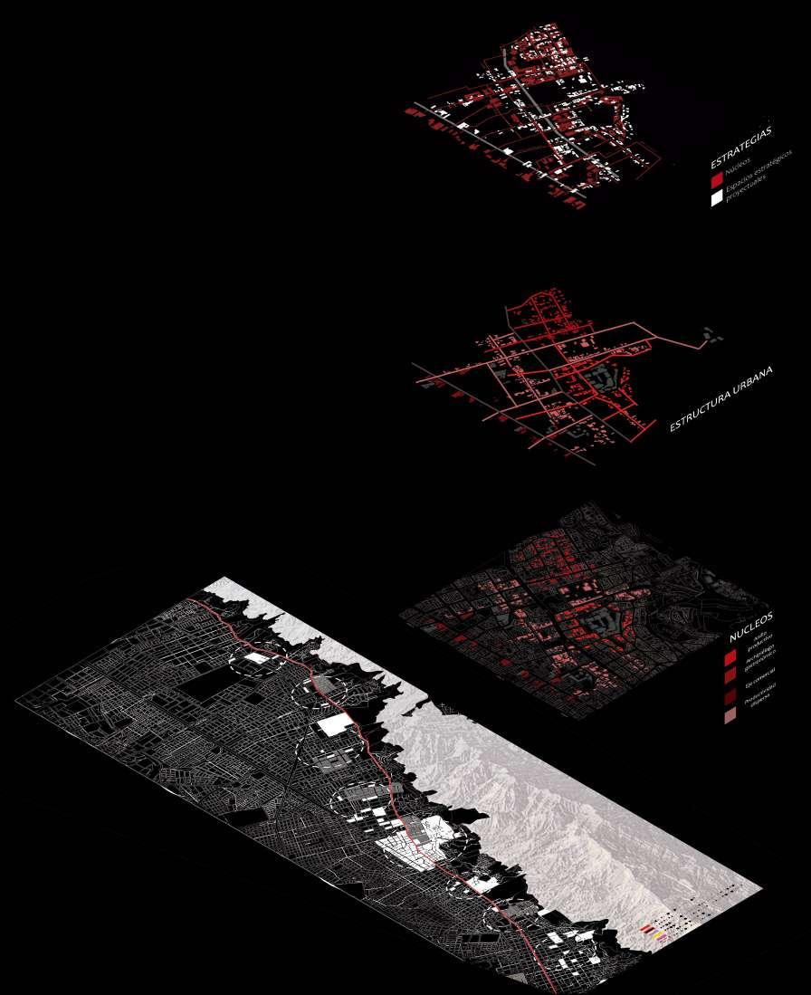
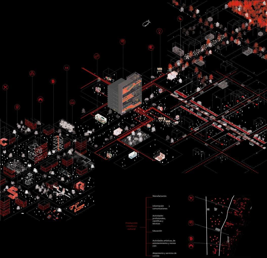
Based on the general analysis and the vision taken according to the trends of the territory, a master plan is designed to enhance production, complement and support the other services, achieving greater cooperation between them and an improvement in the quality of life of the inhabitants. This, by means of specific interventions, located in strategic places so that they function as axes, catalysts and connectors between the same sector and with the rest of the city.

Habitat Project Sxxi Housing Cooperative
June 2021
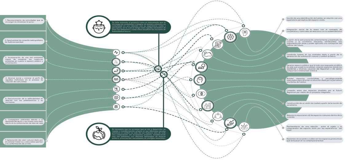
The housing cooperative project is located in the west of the city of Bogotá, in the upz Fontibón. In this project an analysis was made of what contemporary and future habitation means and implies. Based on this, we propose a restructuring of the Santander neighborhood, with the implementation of a mixed housing project, 100 street with 22th avenue, where one of the stations of the regiotram project will settle. Coming to propose a post-covid housing cooperative based on a circular, selfsufficient and sustainable economy; using design to help revitalize a neighborhood on the outskirts of the city and to provide its residents with a unique environment that encourages community generation.

We are located in the western periphery of Bogotá, sector of Fontibón where we saw different opportunities since in the future the station of Regiotram of the west will be located, we also appreciate the tourism potential of the sector while being located near to the international airport. This analysis led us to identify certain problems in the quality of the habitation of the users of the sector among which we observed an overcrowding in the houses and a lack of connection to surrounding public spaces, therefore the inhabiting does not satisfy the basic needs of the users.

Bogotá, Colombia West
High population increase
Research Methodology
Tourism potential
Deficit of 2m2 of square public space per inhabitant.

Urban center
Inhabit Biograms
4.80 N
Collage inspired of “Parables for the Virtual Movement-Affect-Sensation”. Own elaboration.
Conformation of the proprioceptive dimension of the Hyper Topological Figure which is that final perception of the user with its habitable environment.


A - Estación de transporte masivo
B Espacio verde cerca a la vivienda
C Acceso a un comercio zonal o local cercano
D Condiciones certificadas de una arquitectura sostenible
E Cercanía a espacios culturales
F Espacios productivos
A Sala/comedor
B Cocina y zona de ropas
C - Terraza
D Estudio
E - Habitación
F Baño
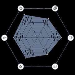
A - Iluminación natural
B - Materialidad
C Conexión con la naturaleza
D Creación de comunidad
E Confort acústico
3.96 4.11 3.45


