2 minute read
Southern


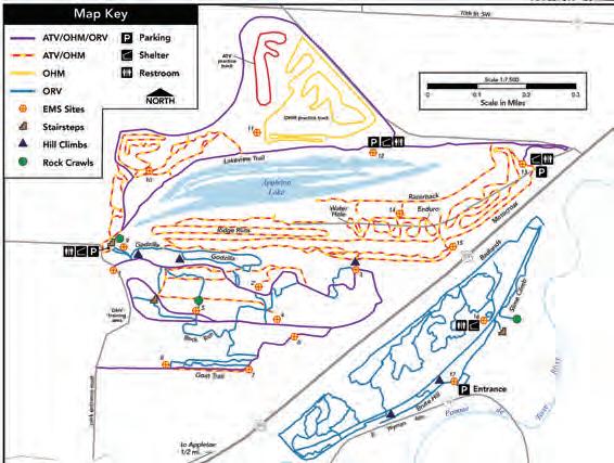
Appleton Area Recreational Park
This gravel mine turned offroad park is a destination for riders in Southwestern Minnesota and beyond. The park includes 20 miles of trails, many technical, as well as a motocross practice track, a training course and dunes, rock climbs and a water pit for muddy fun. The city of Appleton also allows ATVs to travel on posted roads within city limits.
Distance: 20 miles/330 acres Parking/Trailhead Location(s): From Appleton, go one mile east on Highway 59. Season: Year-round Facilities: Appleton: Food, fuel, restrooms, lodging More Information: Michael Johnson, 320-843-5341
Southeast Minnesota Trail
Experience true bluff country on the 13 miles of the Southeast Minnesota Trail. Take in heavily wooded ravines, undulating farmland (watch for cattle) and valleys. Respect the trails and signage, as portions of the trail pass through private property. The Southeast Minnesota ATV Club maintains this trail.
Distance: 13 miles Parking/Trailhead Location(s): From Stockton, go one mile west on Highway 14 to parking area Season: May 15 to October 31 Facilities: Stockton: food, fuel, restrooms; Winona: food, fuel, restrooms lodging More Information: Lee Potter, 507-450-7190

Chatfield Trail
The 19-mile Chatfield ATV Trail is a labor of passion: it was developed by area residents who love ATVs. The trails are entirely on private land, including land in the Dorer Memorial Hardwood State Forest. This easy rural trail travels through farming landscapes, along streams, fields, pasture and woods. A scramble area in an active sand quarry along the way offers additional challenges. The trail is maintained by the Chatfield ATV Trails Club.
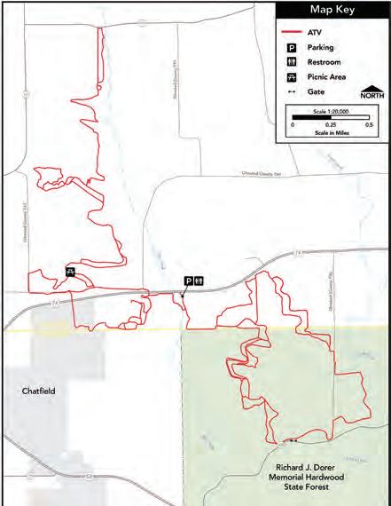
Distance: 19 miles Parking/Trailhead Location(s): One mile north of Chatfield on State Highway 74 and 30. Parking is on the right side. Season: May 1 to October 31 Facilities: Chatfield: food, fuel, restrooms; Rochester: food, fuel, restrooms, lodging More Information: Bernie Hammell, 507-867-4410

Snake Creek and Trout Valley Trails
These trails, many of them one-way routes, are located in a section of Richard J. Dorer Memorial Hardwood Forest that extends along the Mississippi River Valley. They do not connect, but offer similar features: some of Southern Minnesota’s most scenic high points that look over area river valleys. Outcroppings, rubble and a 300-foot climb in Snake Creek make this a challenging day. Camping is available at Trout Valley. Watch for bikers and horseback riders at Trout Valley.
Distance: Snake Creek 13 miles, Trout Valley 9 miles Parking/Trailhead Location(s): Snake Creek: From Kellogg, go 3 miles south on Highway 61. Trout Valley: From Winona, go 15 miles northwest on Highway 61 and then 1.7 miles southwest on County Road 29. Season: May 1 to November 1 Facilities: Kellogg: food, fuel, restrooms, lodging; Minneisha: food; Winona: food, fuel, restrooms, lodging More Information: MN DNR Parks and Trails, Rochester, 507-206-2847

Tri-County Park
An old gravel pit with steep sides near Faribault makes an ideal scramble area and training facility where drivers can hone skills. There is a picnic area with an observation deck on the premises. The Tri-County ATV Club maintains this park.
Distance: 25 acres Parking/Trailhead Location(s): From Faribault, go 4 miles north on Highway 3 to Landfill Road (145th Street E.), then .6 miles east to parking lot on right. Season: April 1 to November 30 Facilities: Faribault/Northfield: food, fuel, restrooms, lodging More Information: Joan Trahan, 507-210-0997


