
7 minute read
Northwest


Forest Riders Trail
The 100-mile Forest Riders ATV Trail is just that: a tour of four state forests. Trails connect Two Inlets, Smoky Hills, Paul Bunyan and White Earth. All those miles mean you’ll get a little bit of everything, from mild-mannered roads winding through the forest to more difficult terrain that will challenge experienced riders. This trail also connects to the Schoolcraft and Round River trails on the north end. Camping is available in the Paul Bunyan State Forest (near Emmaville) and in Two Inlets State Forest. The Forest Riders ATV Club maintains these trails.
Distance: 100 miles Parking/Trailhead Location(s): From Park Rapids, take Highway 34 east to County Road 4. Travel north to the intersection at County Road 24. Season: May 1 to October 31 Facilities: Two Inlets/Emmaville: food, fuel, restrooms, lodging More Information: Ron Jensen, 218-732-4205
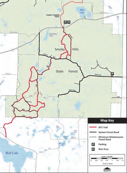
New! Smoky Hills
This new ride area, primarily within Smoky Hills State Forest, offers a blend of dedicated ATV trail and forest roads. It connects to the southern portion of the Forest Riders Trail. The terrain is rolling and the forest is dotted with small, shallow lakes and a mix of hardwoods and jack pines. Head here to see the fall colors. The Woods and Wheels ATV Club maintains these trails.
Distance: 20 miles
Parking/Trailhead
Location(s): West 4 miles from Osage on Highway 34, or south on Becker County Highway 123 and west of Wolf Lake Forest Road. Season: May 1 to October 31 Facilities: Osage: food, fuel, restrooms More Information: Alex Myers, 701-371-9637
Forest Riders Trail • Smoky Hills • Schoolcraft Trail • Round River Drive Trail/Martineau Recreational Trails • Beltrami Island State Forest • Bemis Hill Trails • Fourtown-Grygla / Con-Con Trail System • Warroad/ Roseau Trails • Huntersville Trail • Agassiz Recreational Trail • Wilton Trails Northwest
Schoolcraft Trail
The 29-mile Schoolcraft ATV/OHM trail serves as a connector route with benefits; and those benefits are multiple options that take riders the same direction, but with choices. The trails span between the Forest Riders ATV Trail in Lake George and the northern Paul Bunyan State Forest. This trail has its own charms, traversing forest and township roads through hilly terrain peppered with ponds and bogs. The Northwoods Riders OHV Club maintains this trail.
Distance: 29 Parking/Trailhead Location(s): From Bemidji, travel 6 miles south on Highway 71. Turn west on County Road 9 for 3 miles then south for one block on Reverse Trail. Parking is also available at the trailheads near Lake George on Highway 71 or off of Highway 9. Season: May 1 to October 31 Facilities: Lake George: food, restrooms, lodging More Information: Hubbard County, 218-732-4750


Things grow large in the Paul Bunyan State Forest, including off-road opportunities. The Round River Drive and Martineau trail systems provide more than 200 miles of trails showcasing the area’s unique postglacial moraine landscape. Much of the trails follow forest roads. This system connects to the Forest Riders Trail. Martineau is OHM only and features technical and narrow single-track trails, as well as some suitable for beginners. The Paul Bunyan Forest Riders Offroad Club maintains the Martineau trails.
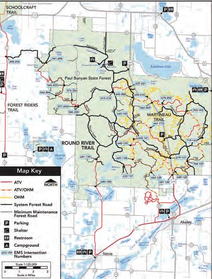
Distance: Round River Drive: 107 miles; Martineau Recreational: 97 miles Parking/Trailhead Location(s): In Akeley and about 6 miles north of Akeley off of Highway 64. Turn left off Blue Trail/Steamboat Trail Season: May 1 to October 31, with occasional closures for logging operations Facilities: Akeley: food, fuel, restrooms, lodging; Martineau Recreational Trail parking lot: restrooms More Information: Hubbard County, 218-308-2367 or 218-732-4270
Beltrami Island State Forest & Bemis Hill Trails
The second-largest state forest in Minnesota offers an impressive 238 miles of off-roading trails through the deep northern woods, with 96 miles in the Bemis Hill Trails system. Once an island on glacial Lake Agassiz, Bemis Hill Trails take riders on a scenic ride through pine forests, along rocky glacial ridges and past peat bogs. Five rivers have their headwaters in this forest. The forest is classified as “managed” for motor vehicles. ATVs, ORVs and OHMs are allowed on roads, routes and designated trails. Bemis Hill Trails are maintained by the Roseau/LOW Sportsman’s Club.

Distance: 238 miles; of which 96 miles are Bemis Hill Trails Parking/Trailhead Location(s): From Warroad, take County Road 5 south for 11.5 miles to the Clear River Day-use Area. Access also available at Bemis Hill Campground and Hayes Lake State Park. Season: Open year-round, except on groomed and signed snowmobile trails. Facilities: Baudette/Roseau/Warroad: food, fuel, restrooms, lodging; Wannaska: food, fuel More Information: Myles Hogenson, 218-689-6889
So what goes on outside of the Beltrami State Forest? There are 263 miles of trail, primarily on road right-of-ways, ditches and some trail, on the Fourtown-Grygla and Con-Con networks that are southwest of the forest. ATVs are allowed to operate on the far right side of the travel lane of county and township roads, but always exercise caution when sharing the road. The trails are maintained by the Fourtown Grygla Sportsman’s Club.
Distance: 170 miles Parking/Trailhead Location(s): In Grygla at the intersection of Marshall Avenue and West State Street; in Fourtown at the intersection of Highway 89 and County Road 18. Season: June 1 to October 31 Facilities: Grygla: food, fuel, lodging; Fourtown: food, fuel More Information: Ryan Petersburg, 320-815-1996
Warroad/Roseau Trails
Call this Beltrami East: the Warroad/Roseau Trail system provides riders with a second option through the Beltrami Island State Forest. It offers easygoing rides through the region’s low flatlands, peat bogs and pine-covered ridges. A picnic area and restrooms are located at the Carp’s Pit Recreation area. Trails are open in the winter, but not on signed snowmobile trails. The Roseau/LOW Sportsman’s Club maintains the trails.
Distance: 89 miles Parking/Trailhead Location(s): From Warroad, take County Road 5 south for 11.5 miles to the Clear River Day-use Area. Parking also south of Roosevelt at Carp’s Pit and in Williams. Season: Open year-round, except on groomed snowmobile trails. Facilities: Warroad: food, fuel, restrooms, lodging, camping; Williams: food, fuel, restrooms, lodging More Information: Myles Hogenson, 218-689-6889

Agassiz Recreational Trail
The Agassiz Recreational Trails, near the North Dakota border, are a multi-use route used by ATVs, cyclists and horseback riders. The route follows an abandoned railroad corridor between the towns of Ulen and Crookston, and offers pastoral rural and lightly wooded landscapes. Bridge crossings over the Wild Rice and Sand Hill rivers are among the highlights of this easygoing day out. Maintained by Clay, Polk, and Norman counties.
Distance: 52 miles Parking/Trailhead Location(s): Parking and trail access in Ulen and Fertile. Season: April 1 to November 30 Facilities: Fertile: food, fuel, restrooms, lodging; Twin Valley/Ulen: food, fuel, restroom More Information: Clay County: David Overbo, 218-784-7126; Norman County: Jerilyn Swenson, 218-784-7126; Polk County: Richard Sanders, 218-470-8253
Wilton Trails Northwest
There’s another section of the Soo Line North Trail (see the North Central section) that doesn’t connect with the rest, and goes under the alias Wilton Trails Northwest. This system is partly a straight shot northwest from Bemidji, but there are enough side trails that one way can be fast, the other can be adventurous. The trails run though sections of the Mississippi Headwaters State Forest, and the towns of Wilton and Pinewood. The trail features scenic valley overlooks. The Northwoods Riders OHV Club maintains the trails.
Distance: 37 miles Parking/Trailhead Location(s): Access from Bemidji: take Highway 2 for 3 miles, and then turn south on Pete Lane (before Highway 89 junction). Season: May 1 to October 31 Facilities: Bemidji: food, fuel, restrooms, lodging, camping More Information: Beltrami County, 218-333-4164
Huntersville Trail
The Huntersville Trail provides a less technical alternative to the nearby Martineau Recreational Trail, with the majority of trails dedicated to off-road motorcycles. ATVs are allowed on 52 miles of forest road, all within Huntersville State Forest. While much of the trails are single-track, there are two-track and service roads that make for less of a challenge, and all trails are marked with their difficulty. The Twin Cities Trail Riders maintain the trails.
Distance: 59 miles Parking/Trailhead Location(s): Parking and trail access west of Huntersville off County Road 24 or east off County Road 18. Season: Year-round Facilities: Menahga: food, fuel, restrooms, lodging More Information: Tom Umphress, 612-965-8618


