30 minute read
Brock Barrow


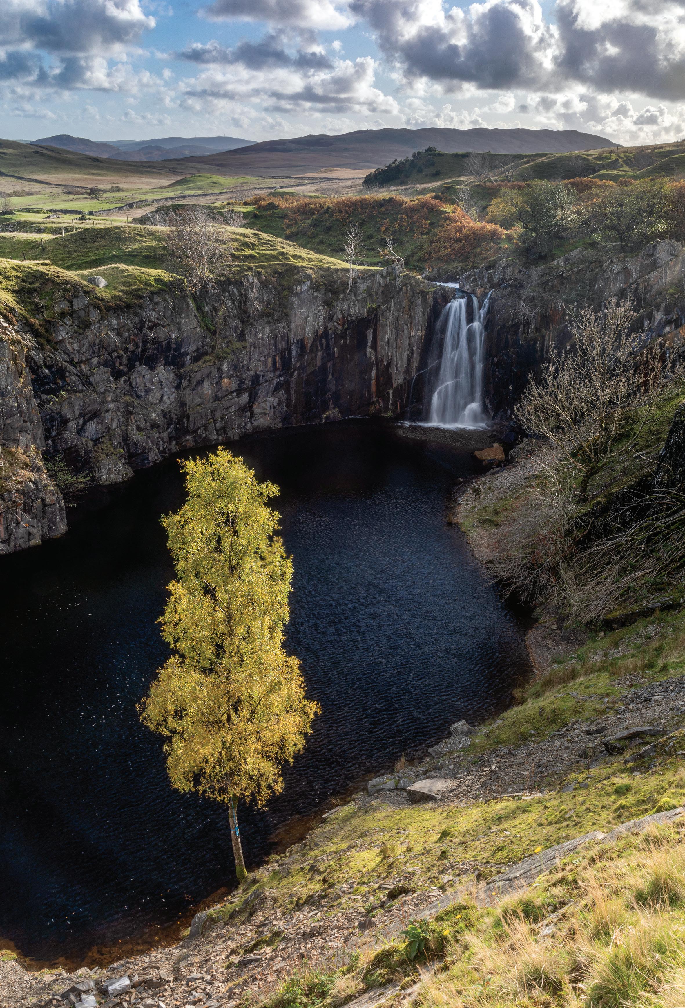
Banishead Quarry waterfall is said to have been created in the late 1950s by a couple of young local lads who removed the stones that prevented the stream dropping into the quarry hole. This act of vandalism didn’t go down well with the local farmers when the water level rose and started flowing out of the adit and down through the tips eroding the track. The farmers managed to re-divert the stream back to the main channel but the damage was done. Looking on the bright side it makes a fantastic little photo location.
Advertisement
What to shoot and viewpoints
Viewpoint 1 – Walls on the walk in
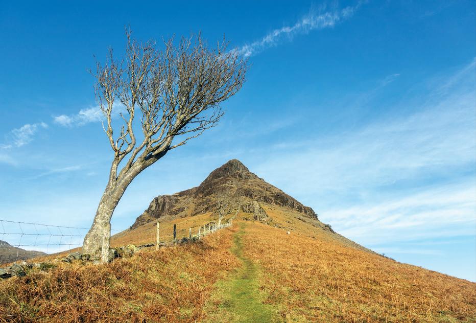
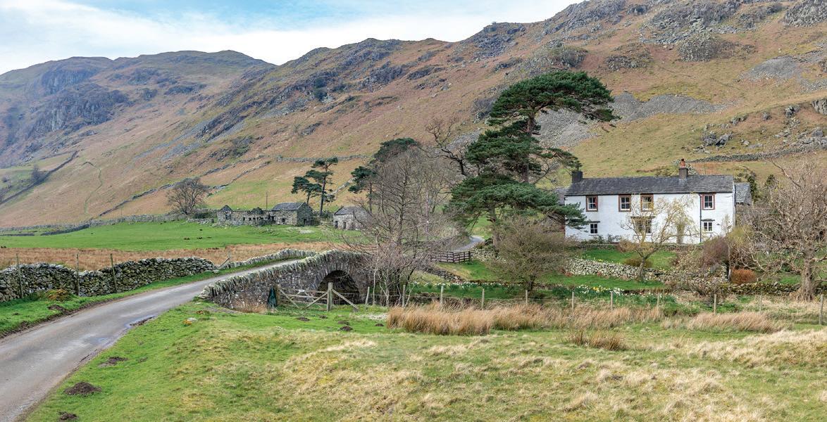
Walk up the road and veer left towards Scar Head Campsite then right following the tarmac road to its end. There are bridleway signs marked for Walna Scar. The road turns into a track past the houses and becomes rough and stony making it unsuitable for wheelchairs. Coniston Old Man comes into view directly in front with a walled track and stone barn for foreground which works well in the morning or evening light. Stay right at the barn and past a small quarry. The well built walls here lead your eye towards Dow Crag up beyond with an isolated thorn tree on the side of the track to add interest.
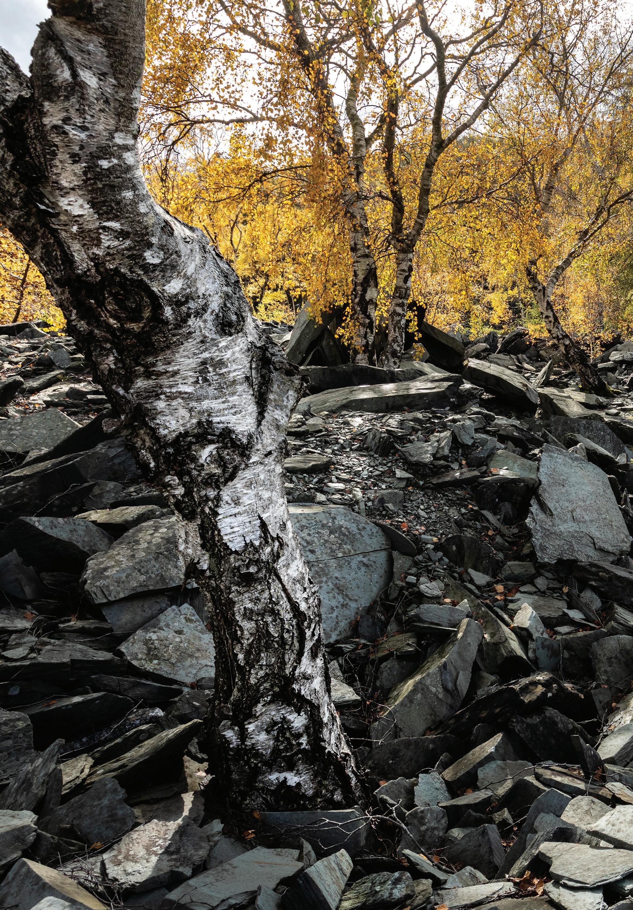
Opposite: A backlit autumn tree and polariser give good contrast. Canon 5D MkIV, 24–105 at 32mm, ISO 100, 1/5s at f/22, polariser, tripod. Oct.
Dow Crag and Coniston Old Man on the walk in. Canon 5D MkIV, 24–105 at 60mm, ISO 100, 1/80s at f/10. Oct.
You reach a farmhouse up to the left and a gate and stream, cross the bridge and aim for the large spoil heap ahead. On arrival at two gates, go through the right hand one and across the stream. You are now 1.5km from the roadside parking. The path passes below the large spoil heap which has an interesting tree on its right slope. The deep hole of Banishead Quarry (SD 278 959) is located a further 320m up the path and is fenced off.

Viewpoint 2 – East end of the quarry
This is a morning location if it’s sunny unless you want the sun to the side or in your face but that would put the falls in deep shadow. With an early sun the waterfall at the far end of the pool will be illuminated as well as the colourful ‘rusted’ rocks on the right of the falls. There is a steep path down to the water’s edge at this end, take care as it’s loose. Some good images can be had from up high on the sides as well as at the water level. The birch tree can be framed against the water, in autumn the leaves turn yellow and can be very effective when backlit in the afternoon. A polariser is useful for getting rid of reflections making the tree stand out against the water. A still day is best here or you could try to use a ND filter for a long exposure to smooth ripples.
Viewpoint 3 – West end
Walk around the north side of the quarry hole to find another path down to the water’s edge. This vague path is extremely steep and loose and great care should be taken to avoid a fall and injury or take an early bath. From down here you are looking across the rusty rocks to the side of the falls. There are gorse bushes down here too which can be very colourful when in flower.
Viewpoint 4 – Downstream waterfall
The water that cascades into the quarry is only a fraction of the stream flow. The main part continues downstream where there is a further waterfall in the main stream itself. This involves another scramble to get down but it’s not too hard. The stream flows over a smooth slab which could be good for some high speed photography or abstracts.
You can continue up on the main path to reach the Walna Scar Road from where you can descend back to Coniston village or return the same way you came up.


Viewpoint 5 – Coffin Route.
If you don’t fancy the roadside path there is a lovely walk along the picturesque old Coffin Route back to Rydal which climbs high above the road and offers views looking generally south over the lake. To find the path you need to go to the right end of White Moss car park and follow the path beyond but instead of turning up immediately left, cross the main road bridge over the stream and take the path that climbs up left from here. Once up on the coffin route there are stone walls, mossy rocks, old oak trees and a lofty position giving views to the fells including Wetherlam and Coniston Old Man. Further along as you start to descend towards Rydal village you have a good clear view west up Rydal Water including the islands. You arrive at some trees and then pass above the gardens of Rydal Mount. At the road turn right and go down the hill past Rydal Hall and the church to the main road. Go left and it’s a short walk back to Pelters Bridge.

South shore: The footpath and wall makes good leading lines. Canon 5D MkIII, 100–400 at 200mm, ISO 100, 1/320s at f/5. Nov.
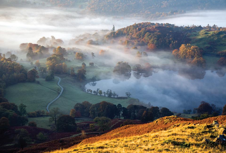
Opposite: From the north shore on a misty morning. Canon 5D Mk IV, 100–400 at 300mm, ISO 100, 1/250s at f/14. Sept.
Blindtarn Gill Easedale Beck
To Thirlmire & Keswick The Swan
Sam Read Bookseller
yha
Allan Bank
Heaton Cooper Studio
Grasmere
B5287 River R o thay A591
Forest Side Heron Pike 612m
VP3: Alcock Tarn
9 Alcock Tarn
VP2: Grey Crag
Lord Crag June May/JulyApril/August March/Sept
Feb/Oct Jan/Nov Dec
June May/JulyApril/August March/Sept Feb/Oct Jan/Nov Dec
SUNSET SUNRISE
Wray Gill
Silver How
The Wyke Wyke Plantation
Hunting Stile
Spedding Crag
Chapel Stile
B5343
Dow Bank B5287Wordsworth
Grasmere
wordsworth.org.uk
Daffodil Hotel & Spa
Grasmere
Redbank Wood
VP4: Woodland Wall
Huntingstile Crag High Close
yha Wordsworth Museum VP1: Yew tree
0 metres 500
Dove Cottage Cottage
Town End 8 White Moss
Nab Scar
VP2: First VP1
Summit
VP3: Far summit VP2: Footbridge
White Moss Car Park
VP5: Cof n Route
VP1: River Rothay
Nab Cottage William Wordsworth 5 at Rydal
Rydal Hall River RothayBaneriggs 7Loughrigg Terrace Loughrigg Fell Ewe Crag Intake Wood A591 A591 To Ambleside RydalRydal Mount Lanty Scar Loughrigg Cottage 3 Loughrigg Holme River Rot hay 335m
VP4: North Rydal Shore VP3: Panoramic 6 Water VP1: East End Grasmere VP3: South Shore Loughrigg Terrace VP2: Rydal Cave VP5: Skyline views Loughrigg Lane & Fell VP6: to the summit Pelter Bridge
Pelter Bridge Car Park

How to get here
From Ambleside follow the A591 towards Grasmere and Keswick. You pass through Rydal Valley which has many fine trees close to the road, some on raised rocky knolls that are especially good to photograph in misty and low light conditions early in the morning.
Just over a mile outside Ambleside turn left over the narrow Pelters Bridge. After the bridge turn immediately right up a small lane to a car park on the left. It’s also possible to start from the other end of the lake at the White Moss car parks.
Lat/Long: 54.445172, -2.9816186 what3words: ///twinkled.vibrates.revolts Grid Ref: NY 364 059 Postcode: LA22 9LW
Accessibility
The complete circuit around the lake is 5.5km and should take around two hours following good tracks and paths. The trails are a little rough in places and are not wheelchair friendly.
Best time of year/day
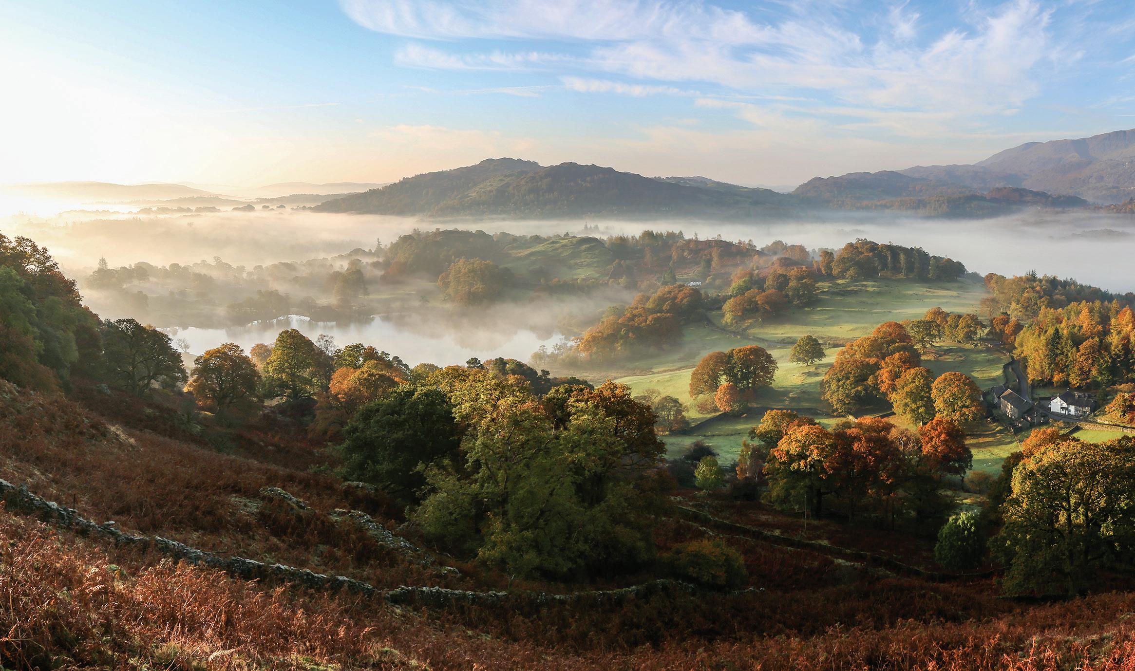
In winter the lake occasionally freezes over to spectacular effect. Springtime brings new growth with lots of daffodils and bluebells. In summer all is green and lush. Autumn brings morning lake mists and vibrant colour in the trees. The best time of day is early morning to catch the mist and spot any wildlife, or late afternoon/ evening to make the most of the golden hour.
East end of the lake. Canon 5D Mk III, 15mm fisheye, ISO 100, 1/60s at f/9. June. Above: Rydal overlook from the south side. Canon 5D Mk III, 17–40 at 17mm, ISO 100, 1/80s at f/13. June.

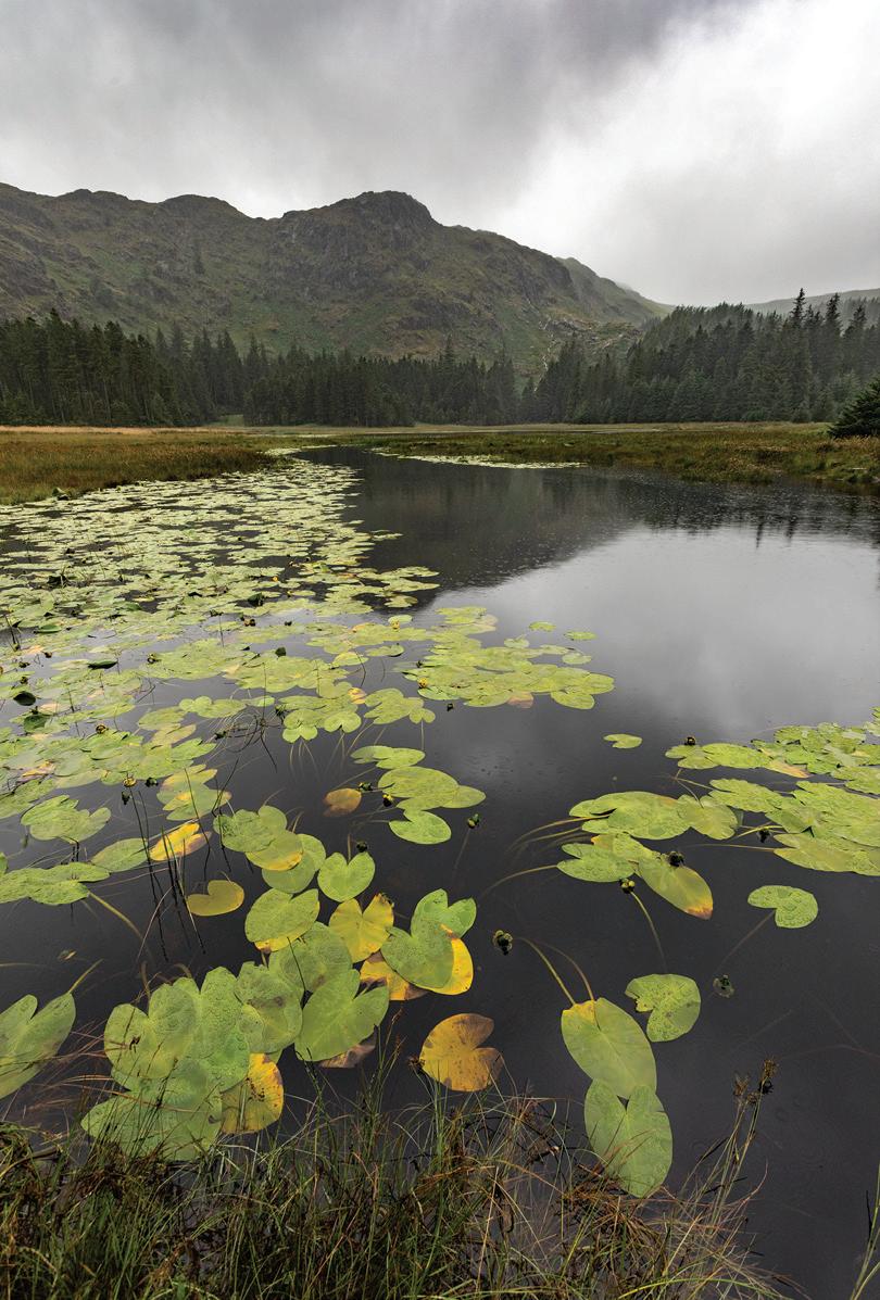
Loughrigg Tarn is a beautiful circular valley lake surrounded by farmland and a variety of trees. On a windless day the Langdale Pikes are reflected in the still water. It is situated just north of Skelwith Bridge, outside of Ambleside. In the summer the tarn has a carpet of yellow water lilies and was a favourite location of William Wordsworth, who described it as ‘round, clear and bright as heaven.’
What to shoot and viewpoints
Viewpoint 1 – Tarn overview
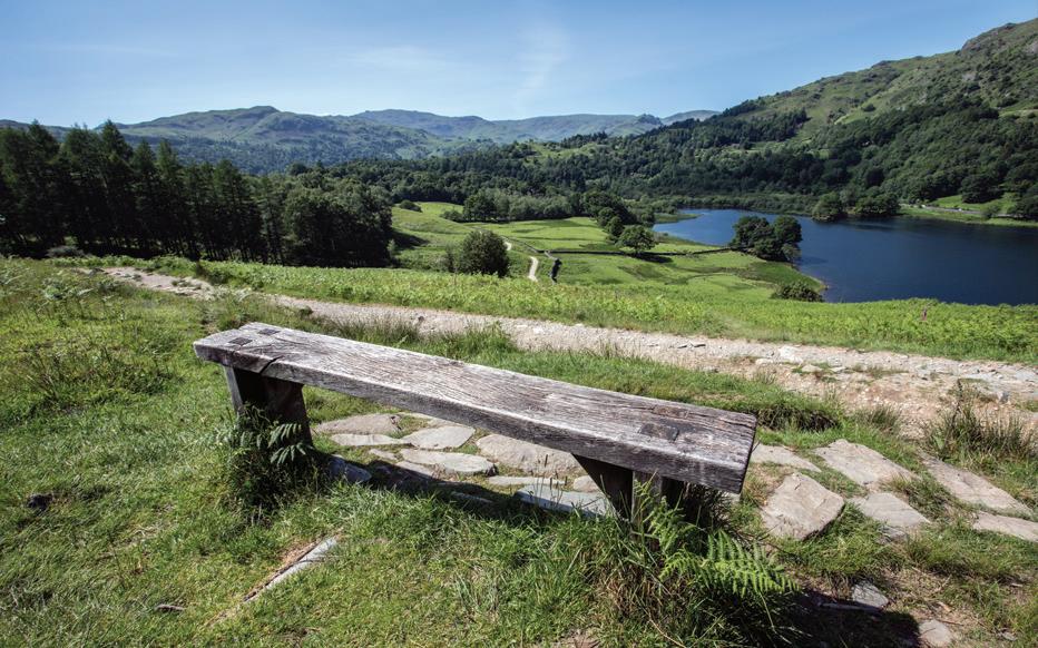
On the path just beyond the campsite the view opens out revealing the tarn below with the Langdale Pikes beyond. There are a couple of benches here to sit and while away your time. It’s an idyllic spot to photograph the sunset.
Viewpoint 2 – Lakeshore
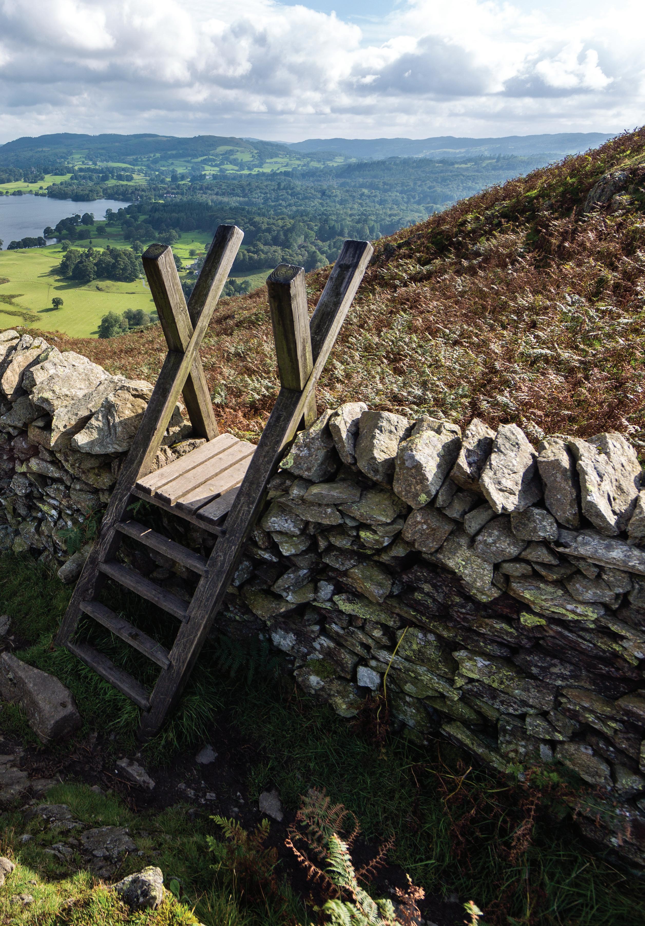
Go over the stile in the metal fence down to the tarn edge. There are many vantage points here by the water with trees, boulders and lily pads in the foreground, and on the left a wall and fence to add foreground interest.
Viewpoint 3 – Cottage
Above the tarn. Rather than dropping to the lakeshore, follow the track along past The How, a beautiful traditional cottage, for a different perspective of the fields, trees, fence and tarn.
Viewpoint 4 – Loughrigg Fell
The slopes of Loughrigg Fell. Just beyond The How a path heads off through a gate on the right. A National Trust sign points to Loughrigg Fell. The path follows the wall for 300m with occasional good views between the trees of the Langdale Pikes. Just before a stile and a stream, head steeply up the fell. The path is stepped most of the way and represents the most direct way to the summit of Loughrigg Fell. A rocky knoll part way up provides a great vantage point down onto Loughrigg Tarn, Elter Water, into the Langdales and up onto Wetherlam. The path leads directly to the summit of Loughrigg Fell where there are superb views in all directions, well worth the effort.
Opposite top: The tarn from the slopes of Loughrigg Fell. Canon 5D MkIII, 24–105 at 55mm, ISO 100, 1/100s at f/5.6. Oct.
Opposite: The Langdale Pikes beyond the tarn. Canon 5D MkIII, 24–105 at 47mm, ISO 200, 1/320s at f/11. Sept.
Stitched panorama from Loughrigg Fell. Canon 5D MkIII, 24–105 at 24mm, ISO 100, 1/60s at f/11. Oct.

How to get here
From Ambleside follow the A593 towards Skelwith Bridge for 2 miles. Turn right up Ellers Brow, a narrow and very steep road signposted ‘High Close 1.5 miles.’ Drive up this road, pass a farm and up the hill, continue straight at a junction to another junction where you will find various parking lay-bys.
From the lay-bys walk down the road (turn right from Ellers Brow road) to a minor road (a ‘Y’ entrance), opposite a post box in the wall, leading to cottages. Follow this then go right at the junction passing more cottages to Tarn Foot Lodge and take the path through the left of two gates leading to Loughrigg Tarn.
If there is no space in the lay-bys, you can use the B5343 roadside pay and display car park on the right a third of a mile beyond Skelwith Bridge. From the end of the car park follow a path through the wooded fell to Crag Head. The path meets the road on the south side of the tarn, turn left to find the path after 150m.
Lat/Long: 54.427020, -3.0101681 what3words: ///suppers.bets.washable Grid Ref: NY 345 039 Postcode: LA22 9HF
Accessibility
This is a short walk along a fairly level path suitable for wheelchairs. The sides of the tarn itself can get wet and muddy. The climb up Loughrigg Fell is steep.
Best time of year/day
Autumn is the obvious time of year to visit for the colours. There is photographic potential here in any season however. At either end of the day the lakeshore views east and west plus the ease of access mean this is a great location with sunrise and sunset potential. Sunset in summer can be spectacular behind the Langdale Pikes to the north west.


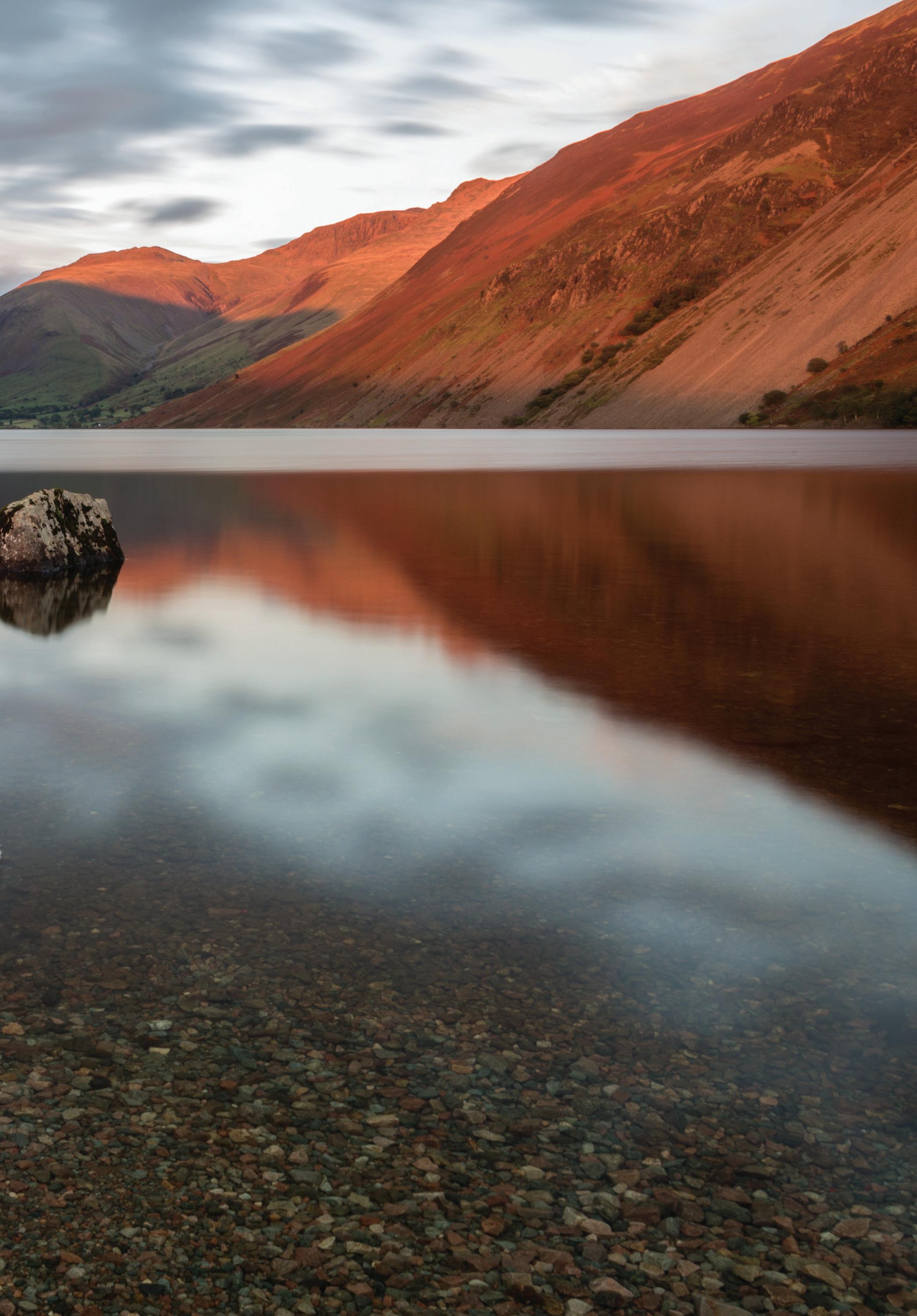


Top: Looking back down Wastwater from above Great Door. Canon 5D MkIII, 24–105 at 24mm, ISO 100, 1/125s at f/11. Feb.
Middle: The ascent path up the ridge of Yewbarrow. Canon 5D MkIV, 24–105 at 24mm, ISO 100, 1/320s at f/8. Jan.
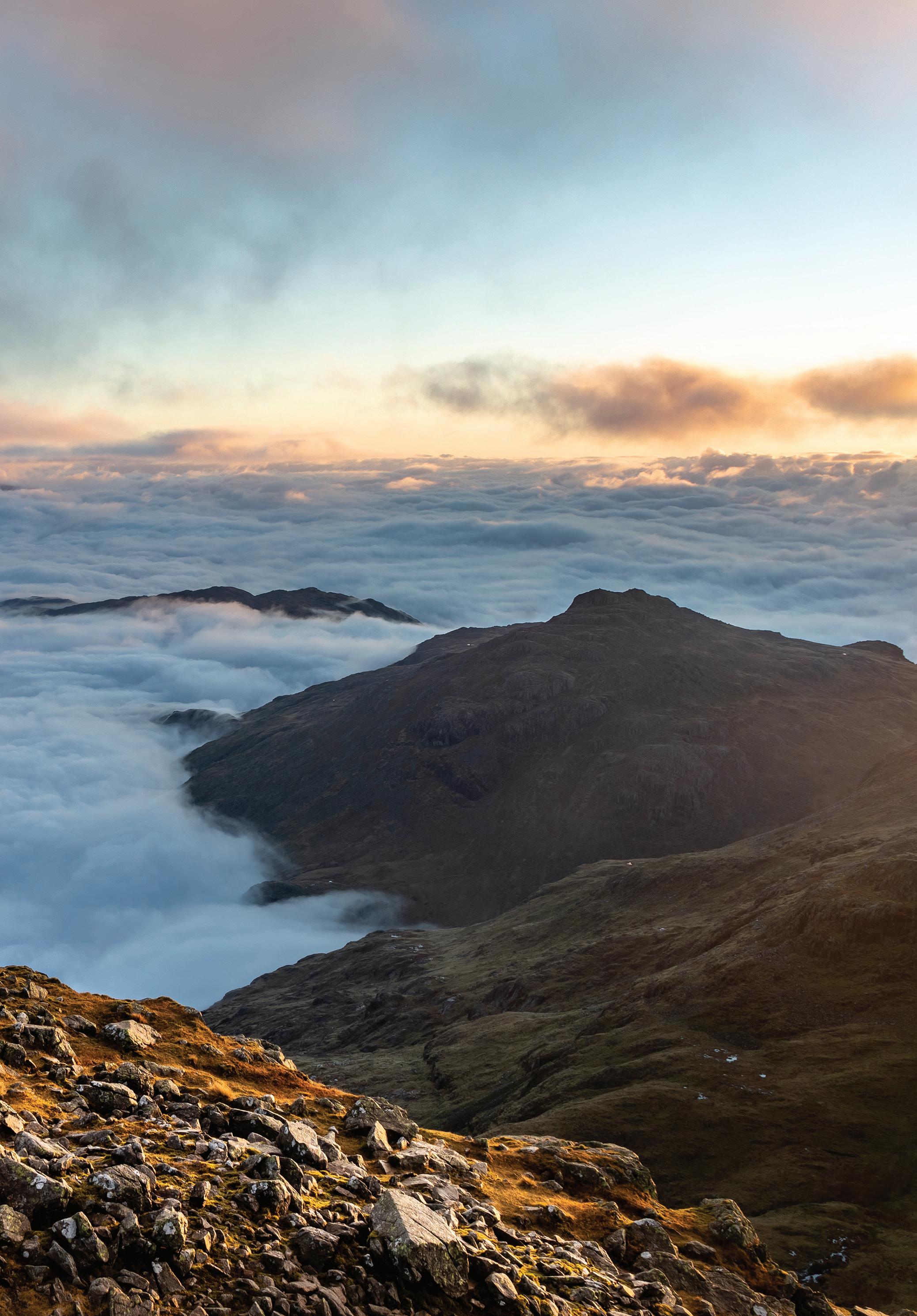
Bottom: Sunset colours on the Scafell peaks. Canon 5D MkIII, 24–105 at 60mm, ISO 100, 1/60s at f/6.3. Feb.
If you don’t want to descend the very steep and notoriously tricky scramble directly down the ridge from Stirrup Crag you need to back track to roughly half way between Yewbarrow summit and Stirrup Crag summit. In the hollow you will find a narrow path marked with a small cairn which makes a gradual descending traverse on the west side below the crags towards the col of Dore Head. When you meet the descent path from Dore Head turn a sharp left and follow this all the way down the valley. The path becomes indistinct in places over boggy bits but reappears again soon after. You end up rejoining the ridge path of the ascent route which should be followed back to the stile, gates and car park.
Opposite: Red Pike and Pillar from Yewbarrow. Canon 5D MkIII, 17–40 at 17mm, ISO 100, 1/60s at f/10. Feb.
How to get here
Accessed via Santon Bridge to the west of Wasdale. Take the road towards Nether Wasdale then after 1.8 miles the road goes over the River Irt flowing out of Wastwater. Turn right immediately after the bridge and continue towards Wasdale Head for 3.6 miles. There is a car park at the foot of Yewbarrow’s west ridge at Overbeck Bridge, 1.7 miles before Wasdale Head.
Lat/Long: 54.449891, -3.2853493 what3words: ///noon.flips.steady Grid Ref: NY 167 068 Postcode: CA20 1EX (Wasdale Head 2.5km)
Accessibility
This is a very steep mountain with a reputation for being the hardest climb to a summit in the Lakes. All routes require use of hands at times and easy scrambling. The climb up is 600m (1968ft) and the circuit is 6.7km. The path is occasionally vague so good map reading skills are necessary in case of bad visibility. There is no wheelchair access here.
Best time of year/day
Yewbarrow can be climbed any time of the year. There are obvious safety issues in icy or snowy conditions, it is a mountain so refer to the notes on being prepared on page 30. Low sun at either end of the day and the winter months will help with added drama and contrast. The primary viewpoint is towards the Scafell range so this favours evening for sunset on these slopes.

‘Scale Force, the white downfall of which glimmered through the trees, that hang before it like the bushy hair over a madman’s eyes’. – Samuel Taylor Coleridge’s graphic description of Scale Force.
Hidden away in a deep tree-lined gorge between Red Pike and Starling Dodd, with a total fall of 170ft, this is the highest single drop waterfall in the Lakes.
What to shoot and viewpoints
The walk in to Scale Force gives good views across Crummock Water to the mountains opposite . There are gnarled hawthorn trees and bluebells in spring.
The falls are in two main parts, the upper slender fall and the wider lower one. There is a path on the side of the stream taking you close to the lower falls. A wide angle works well with rocks or logs in the stream bed as foreground and the falls behind. You may need to get your feet wet to get the best angles. The lush mossy and wooded ravine has a tropical look to it (ignoring the temperature!), especially after rain when the sides are dripping wet. A clearing after a rain storm can give very pleasing shafts of sunlight through the spray mist.
If you are feeling adventurous it’s possible to climb the next rocky steps to get better views of the upper falls and the fallen logs that have created a small dam. This can be dangerously slippery and it’s not recommended.
When framing your shot try to avoid getting sky in the picture that would create a distracting highlight drawing people’s eye away from the main subject.
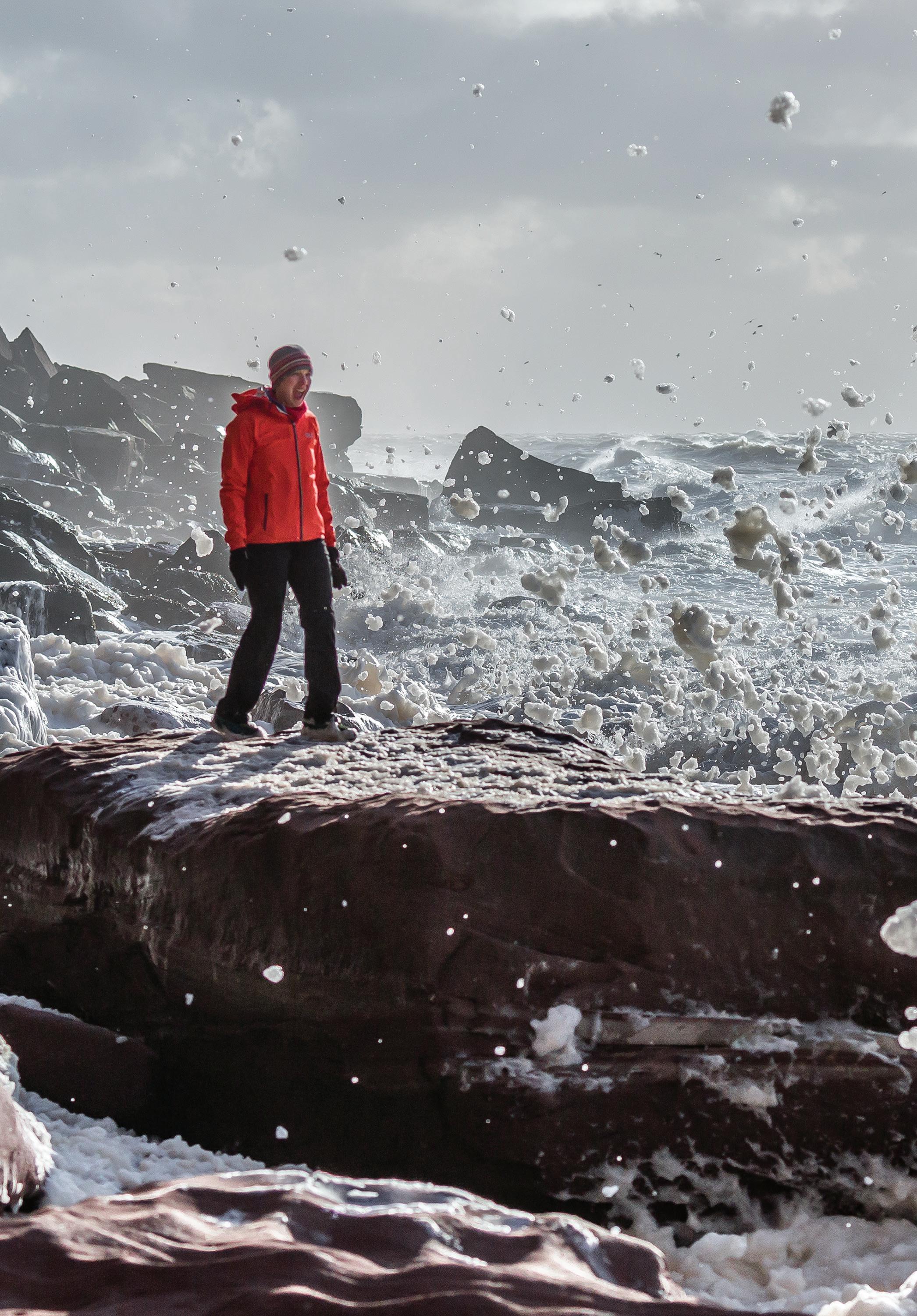
Above the first fall, balanced on slippery rocks. Canon 5D Mk III, 14mm, ISO 100, 6s at f/22, tripod. Nov.
Position a willing friend in the scene to add colour, scale and human interest. Spray from the falls can be a problem, especially when it’s windy. Go prepared with a chamois leather or dry lens cloth to wipe your lens.
It’s possible to climb up to Red Pike from the east side of the beck to follow Location 5 on page 276. The route climbs steeply up the east side of the beck on an obvious stepped path but after 500m veers leftwards away from the beck and up the heathery slopes on less obvious paths to the top of Red Pike.

Opposite: A true friend won’t mind posing in the drenching spray while you spend ages composing your shot. Mamiya 7II.
How to get here
Access is via Buttermere Village and involves a walk of 40-60 minutes one way. Park in the LDNPA car park at the back of the Fish Hotel in Buttermere. Follow the path towards the lake and after 100m go through the kissing gate on the right. From here it’s 700m or 0.4 miles to the attractive hump-backed Scale Bridge. Cross the bridge then turn right. The path is OK until the bridge over Ruddy Beck, around 700m further on. Cross the bridge and take the path on the left going uphill. The path soon becomes a little more vague and wet in places. You are generally aiming for the col between Mellbreak and the lower slopes of Starling Dodd. So long as you are following a path in roughly the same direction and slightly uphill you will eventually reach a gate in a wall after 1.3km or 0.8 miles and around 100m, 330ft, height gain. After the gate continue to a footbridge crossing Scale Beck (NY 150 171) with the waterfalls upstream.
It’s best to take a map and compass and know where you are.
Lat/Long: 54.540904, -3.2782495 what3words: ///juicy.table.harder Grid Ref: NY 173 169 Postcode: CA13 9UZ
Accessibility
The walk to Scale Force is around 3km, with approximately 100m of elevation gain. The footpaths are initially good and easy to follow but become quite vague in places. Allow around one hour to get here. The paths are both rocky and boggy in places so good waterproof boots are essential if you want to keep your feet dry.
Best time of year/day
This waterfall is impressive any time of the year. In winter it has been known to freeze up, during an extended cold spell you can get impressive ice formations building. Due to its north-facing aspect the falls never see direct sunlight. Bright sunny days however can create problems with too much contrast so for photography it’s best to come on an overcast day. This will also allow slower shutter speeds for blurring the water. After heavy rain the falls are very impressive but there is a lot more spray to contend with.


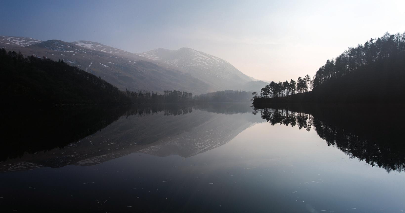

Top: A mirror-like Thirlmere from VP2, the north west shore. Canon 5D MkIII, 17–40 at 29mm, ISO 100, 1/200s at f/18. Mar. Above: Water lillies after rain at Harrop Tarn. Canon 5D MkIV, 100–400 at 400mm, ISO 1000, 1/1000s at f/5.6. Aug. Above: Through trees near Harrop Tarn to the slopes of Helvellyn. Canon 5D MkIV, 100–400 at 227mm, ISO 1000, 1/640s at f/5. Aug. Below: Raindrops on grass at Harrop Tarn. Canon 5D MkIV, 100–400 at 371mm, ISO 500, 1/250s at f/5.6. Aug.


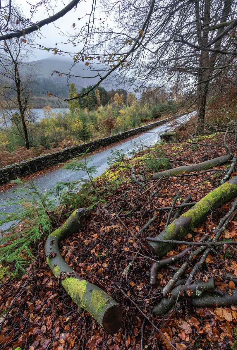
Above: Red squirrels in the forest above Thirlmere. Canon 5D MkIV, 100–400 at 400mm, ISO 1000, 1/160s at f/5.6. Aug. Below: Harrop Tarn on a wet August day. Below right: The road on the west shore of Thirlmere in Nov.
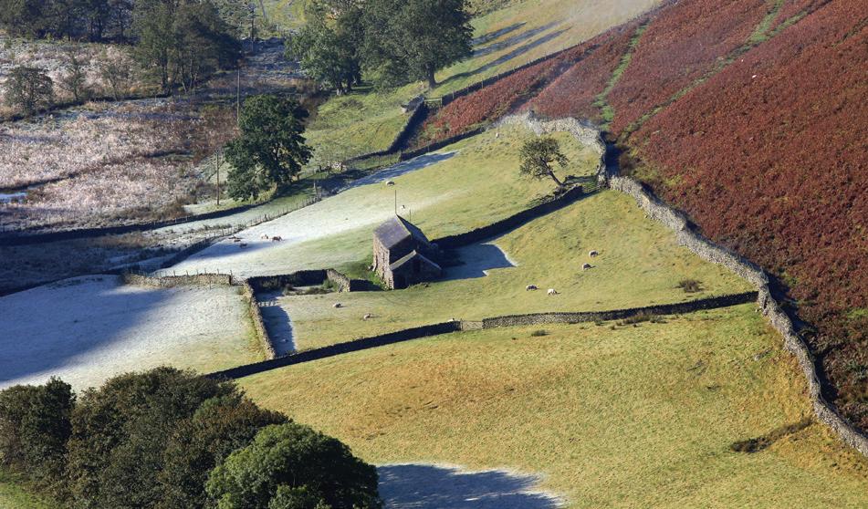
Martindale is a beautiful and remote enclave that seems a world apart from the madding crowds of the Lake District honey pots. Picturesque barns stand isolated in vivid green fields surrounded by dry stone walls and ancient oak trees, all overlooked by sweeping fells of bracken and heather. In the autumn the valleys echo with the bark of red deer stags in rut; the area has the largest population of deer in the UK outside of Scotland.
Barn, fields and a patch of snow from Beda Fell. Canon 5D MkIII, 70–300 at 200mm, ISO 100, 1/800s at f/5. Feb.

What To Shoot and Viewpoints
The Old Church of St Martin
This is said to have existed since 1220 AD although the present construction is ‘only’ around 500 years old. The interior has simple charm with oaks beams and stone flags on the floor, a reading desk installed in 1643 and a Roman font from the time of their occupation. Bring a wide angle lens and a tripod for interior shots.
Yew tree
The ancient twin-trunked yew tree behind the church is estimated to be over 1300 years old. A good composition can be made by carefully framing a long branch of the tree on the left, looking back at the trunks with the sarcophagus to the right.
Barns, fields and fells
From the car park in front of the church you can get a good shot of the fields, barn, tree and walls looking south up the valley. Use a long lens in the evening light for a very dramatic composition. Both of the valleys, Howe Grain and Boredale, have roads going up them and are worth exploring further for barns in fields and valley compositions. The area is rich in wild flowers in spring and summer and there is always the chance of a close encounter with red deer, especially if you venture onto the fells towards the head of these valleys.
Red deer
The best place to see red deer is on the fellsides and valley bottom of the Howe Grain Valley. Continue up the road past St Martin’s Church and drive as far as you can go. Just before Dale Head farm there is a parking spot for two cars, with further roadside verge parking. From here walk through the farmyard and continue up the bridleway. Keep your eyes peeled, the deer seek sanctuary in the valleys of Bannerdale and Ramps Ghyll but you could come across them anywhere around here. Unless you get lucky a long lens is essential if you want to get reasonable shots.
Opposite. Clockwise from top left: Autumn colours in Boredale from Hallin Fell, Red deer on the side of Hallin Fell, Inside the Church of St. Martin. The road up Howe Grain. Snowy walls on the fells above Martindale, Martindale Church.


How to get here
By car: Pooley Bridge at the east end of Ullswater is easily reached from Penrith and the M6 motorway. Follow the B5320 through Pooley Bridge to a small roundabout where you should take the second exit onto High Street. Turn right after 0.2 miles onto the Howtown road. After 3.5 miles the road climbs up some steep hairpin bends to the Coombs. There are roadside parking areas or you can leave the car by the Church of St. Peter. Continue on to the next junction and turn left to find the old Church of St Martin.
Lat/Long: 54.564669, -2.8742937 what3words: ///photos.desktops.dots Grid Ref: NY 435 191 Postcode: CA10 2ND
By Ullswater steamer: take a steamboat from Pooley Bridge to Howtown then take the lakeshore footpath to follow the lake shore or straight on up to climb Hallin Fell.
Accessibility
The walk to the top of Hallin Fell involves a grassy climb of 130m in half a mile, or 800m. The circumnavigation is around 2.5 miles or 4km along generally good footpaths but with occasional short rougher and rocky sections. Good walking boots are recommended. Not suitable for wheelchairs. Much of Martindale can be explored from the roadside including, if you are lucky, getting a good view of the rutting deer.
Best time of year/day
From Hallin Fell the u-shaped valleys of Martindale run due south so either end of the day is best to avoid the sun directly in your camera. Autumn turns the ubiquitous green of summer to a kaleidoscope of colour. Hallin Fell top is often above any cloud inversion on the lake so good for an early start if valley fog is forecast. Martindale makes a good day out any time. The deer rut starts in September and usually lasts through October.


TECHNIQUE NAME
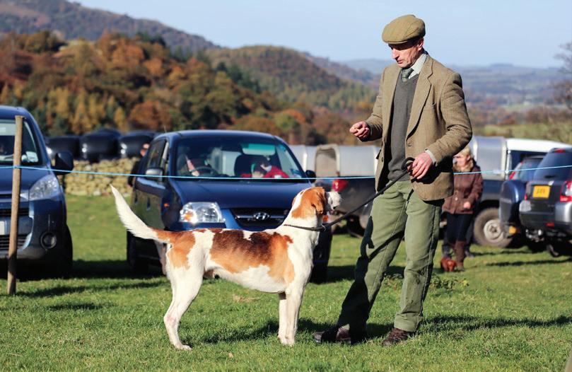
Most counties have traditional agricultural or local shows. Cumbria is no exception but brings its own twist to the genre. For instance have you ever had your beard or boots judged? Any idea what stick dressing is? Have you ever witnessed terrier racing or duckling herding? Local shows are a perfect place to fill a memory card with candids, caricatures and local character.
Each show format is slightly different with attractions that may include any of the following: local crafts including stick dressing, hound trails, fell races, Cumberland wrestling, sheep dog trails, vintage vehicles and machinery, carriage driving, sheep, cattle, dogs and poultry, falconry, tug of war, trade stands, beer tent, Wasdale has a best beard and best shepherd’s boots competition, sheep shearing, terrier racing and duck herding.
On the opposite page is a list of some local shows taking place through the year. Check local information centres and websites for dates and for other shows.
Above: Vintage tractors and stick dressing at Wasdale. Below clockwise: Cumberland wrestling at Borrowdale. Herdwick sheep judging. Quiet stall at Wasdale. One man and his dog, Loweswater.
Some quick tips for photographing at shows.

• Check the event programme to see what is happening when and get to the location early or you may be fighting to get a good viewpoint. • Keep in mind where the sun will be, it’s better to have your subject nicely lit rather than struggling to photograph into the sun. • Less is more, use longer focal lengths to get in close to the action or subject rather than trying to capture the whole venue. • Isolate the subject by using a wide aperture and narrow depth of field. • Don’t hesitate to use the Auto or ‘P’ Program camera setting for grab shots – better to get the shot than miss it whilst fiddling with settings. • Set the scene, look for compositions, backdrop or subjects that identify the event.


A trail hound in full flight near the finish line. Canon 5D MkIV, 100–400 at 400mm, ISO 1000, 1/3200s at f/5.6. Sept.
Penrith Show – July Coniston Country Fair – July Langdale Gala – July Ambleside Sports – Last Thursday in July Rydal Show – Early August Hawkshead Show – August
www.penrithshow.co.uk www.conistoncountryfair.co.uk www.langdale-gala.co.uk www.amblesidesports.co.uk www.rydalshow.co.uk www.hawksheadshow.co.uk Millom and Broughton Show – August www.millomandbroughtonshow.com Cockermouth and District Agricultural Show – August www.cockermouthshow.co.uk Grasmere Sports – Late August Bank Holiday www.grasmeresports.com Lakeland Country Fair, Torver, Coniston – August www.lakelandcountryfair.co.uk Black Combe Country Fair – August www.blackcombecountryfair.co.uk Ennerdale Show – Late August www.ennerdaleshow.co.uk Loweswater Agricultural Show – September www.loweswatershow.com Borrowdale Shepherd’s Meet – 3rd Sunday in September www.borrowdaleshow.org.uk Westmorland County Show – 2nd Thursday in September www.westmorlandshow.co.uk Eskdale Show – September www.eskdale.info/show.html Wasdale Head Show and Shepherd’s Meet – October www.wasdaleheadshow.co.uk World’s Biggest Liar – November www.santonbridgeinn.com
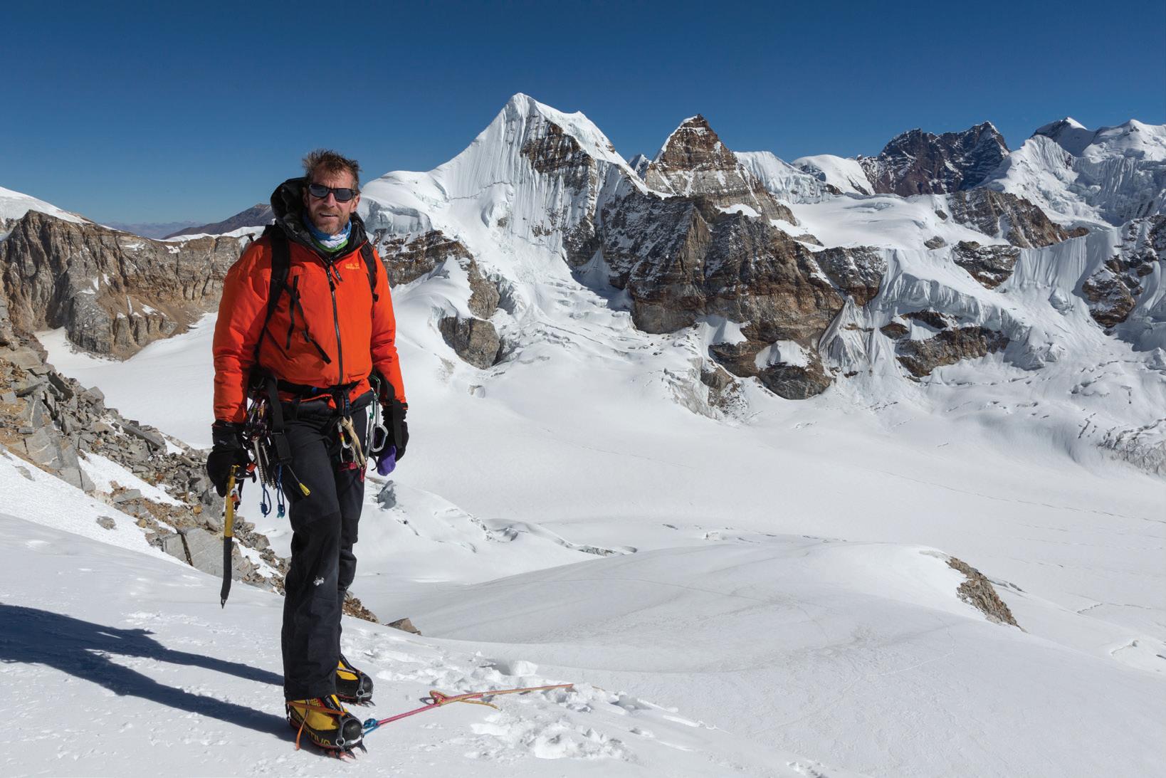
Biography
Stuart is a professional photographer who was brought up around Keswick in the Lake District. What better place to fuel and facilitate a passion for all things outdoors.
After twenty years travelling the world as an exploration geologist he made photography his full time profession supplying images to newspapers, magazines, local tourism agencies and others. Aware of the risks of an ‘all work and no play’ philosophy Stuart continues to be successful at not falling into that trap with regular adventures (pandemic permitting) both at home and abroad.
In 2011 work on the first edition of Photographing the Lake District began after a meeting with Mick Ryan, then advertising manager at UKClimbing.com. In 2014 fotoVUE was officially set up with Mick and Stuart as directors and the Lake District book became the first fotoVUE photolocation guidebook to be published. The next five years saw a further eight titles published with many more being worked on. Stuart stood down from daily duties and directorship in 2019 to concentrate on his own projects leaving Mick to manage an increasingly numerous, varied and exciting range of titles.
Over the last seven years Stuart has worked as a photo guide for Wild Photography Holidays. The typically one to two week-long trips see small groups of like-minded folk of all ages exploring beautiful locations in Iceland, Greenland, Norway and now many other countries including the UK.
Covid 19 did a pretty good job of wrecking all travel plans but Stuart counts himself extremely fortunate during this period to have the Lake District as his back yard; definitely a sanity-saver during lockdown.
So, what of the future? Much depends on the Covid 19 situation along with the increasingly serious climate crisis. To quote Bob Dylan: The Times They Are a-Changin’
Bad hair day in the Himalayas. Descent from Nangmari II in the far north east of Nepal. We failed to make the second ascent by 50m. Canon 5D MkIII, 24–105 at 24mm, ISO 100, 1/400s at f/11. Nov.
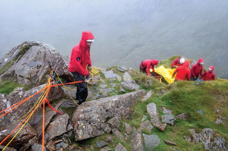
Keswick MRT is one of twelve teams in and around the Lake District. The team comprises up to 50 team members who live in and around Keswick. The team’s area covers the northern part of the Lake District and includes England’s three highest mountains – Skiddaw, Helvellyn and Scafell Pike. In recent years the team has dealt with around 100 rescues a year not including many alerts where the incident has been resolved without the need to send team members out. The team operates anywhere in the Lake District or further afield to assist with major incidents such as searches or flood events.
The team and me
I joined the team in early 2016 and it has become an important part of my life. Callouts can come at any time of day or night and to many different scenarios. People clearly don’t choose when they have an accident or get lost and there is always a buzz of excitement when a callout comes in. Some team members have decades of experience and a few have well over a thousand rescues to their name. This enormous amount of accumulated knowledge stands us in good stead on callouts where younger and fitter members can race up the hill with equipment mentored and guided by older members who have seen similar situations many times before.
I carry a small camera on rescues and if I am not tied up with operations I will record activities for the purpose of pushing the mountain safety message and promoting the team that relies wholly for its existence on donations. Social media has become increasingly important to get safety and conditions messages across to the general public. Our stories are picked up by the local and occasionally by the national press.
You really can’t beat running around on the fells with your mates, going out in all weathers to help folk. Have a look at the team website for more images and information:
www.keswickmrt.org.uk
Right: Great North Air Ambulance assists us on Catbells and a difficult technical crag rescue of a fallen climber on Raven Crag in Borrowdale. Top and above: Descending the snow ridge from the Aiguille Du Midi and ice climbing on the Mer De Glace during pre-winter training in the Chamonix Valley.


fotoVUE guidebooks take you to the most beautiful places to enjoy and photograph. PHOTOGRAPHING THE LAKE DISTRICT
BY STUART HOLMES
FOREWORD BY KERRY IRVING AND MAX –
PHOTOGRAPHER, AUTHOR AND GUARDIAN OF MAX, PADDY AND HARRY
Lakes • Fells • Valleys • Waterfalls • Cottages and Farmhouses • Woodlands • Rivers • Bridges • Boats • Jetties • Wildlife • Classic Views • Landscapes and Panoramas • Villages • Shows and Events • Historic Houses • Castles • Gardens
This comprehensive photo-guide will help all photographers, from beginner to expert, find, explore, and make the most of over 100 of the best photographic locations in the Lake District. Including hundreds of viewpoints and advice on how to get the best photographs.
Author and professional photographer Stuart Holmes has lived in the Lake District all his life and has been taking photographs for over 30 years. His work has been published and exhibited around the world.
For information about all our photo-location guidebooks visit:
www.fotovue.com
£29.95
ISBN 9781916014589


