Yuba Water Agency: Powering a Brighter Future for Yuba County
YUBA WATER AGENCY
Powering a Brighter Future for Yuba County
A History of Devastating Floods: How and Why Yuba Water Agency Was Created on Page 4
60+ Years of Reducing Flood Risk: Yuba Water Agency’s Legacy on Page 3
How to Be Prepared in Case of an Emergency on Page 8
KICKING OFF FLOOD PREPAREDNESS WEEK
A look at projects that should help Yuba County residents sleep better at night, and some great tips on how to be ready and resilient
The Yuba River has been both a blessing and a curse for the people of Yuba County. We have suffered immeasurable damage from flooding over the years, but that same river that caused so much devastation is also key to bringing solutions for some of our biggest challenges.
At Yuba Water Agency, we have spent the last 60+ years laser focused on reducing flood risk for the people of Yuba County. That started with building New Bullards Bar Dam and Reservoir. It continued as we worked with our local, state and federal partners on investments in the Feather River Setback Levee in Plumas Lake and the Bear River Setback Levee in Wheatland. And, it can be seen today in the ongoing work on the Marysville Ring Levee and other levee improvements throughout the county.
The hydropower revenue we raise from our facilities on the Yuba River is what pays for millions of dollars in work to reduce our flood risk, which has also leveraged hundreds of millions more in state and federal investments.
While there will always be risk because we live in an area with rivers and dams, Yuba County is now a community with some of the most modern levees in the state, and our
“We have spent the last 60+ years laser focused on reducing flood risk for the people of Yuba County.”
Willie Whittlesey
Yuba Water Agency General Manager
investments continue, with big plans for major flood risk reduction in the years ahead.
The end of October kicks off Flood Preparedness Week. As you flip through this guide, it is my hope that you will come to appreciate the incredible work that has been done to improve public safety, the effort and investment that we are dedicating to future projects to help us all sleep better at night and the need for us to always be ready and resilient.
Yuba Water Agency does a lot of other really great work, too. We work to ensure a sustainable water supply, improve fish habitat and restore watersheds to protect communities and get our forest to a healthy state where it’s resilient to wildfire. But the #1 reason this agency was created way back in 1959 was because of the repeat flooding, which seemed to be getting fixed elsewhere, but not here. So, the founders of this agency took great risk to invest in the creation of Yuba Water Agency and our facilities – so we, the people of Yuba County – could do it ourselves.
It is an honor and privilege to help lead an agency that is doing so much to reduce flood risk and improve the quality of life for the people of Yuba County. If you would like to learn more about the remarkable story of this little agency that is changing Yuba County for the better, we invite you to view “The Tricky Yuba” on YouTube and visit us on our website – YubaWater.org.
Thanks for reading. I hope you find this content valuable.
Willie Whittlesey Yuba Water Agency General Manager
Construction of New Bullards Bar Dam and Reservoir in the late 1960s.
New Bullards Bar Dam and Reservoir today.
A CONTINUAL EFFORT
BY RAUL CLEMENT
Yuba Water Agency has been committed to flood risk reduction for more than 60 years
Yuba Water Agency was formed in 1959 in response to a catastrophic 1955 flood that displaced 40,000 residents of Yuba City and killed 38. This disaster, caused by a levee collapse on the Feather River, convinced local authorities of the need for an agency to oversee and improve flood control systems in Yuba County.
Since then Yuba Water has worked with other local agencies, as well as the state and federal governments, to continuously reduce flood risk for the region through operational and infrastructure improvements. The agency also oversees water supply reliability, fish habitat protection and enhancement, hydroelectric generation and recreation at New Bullards Bar Dam and Reservoir.
Of the agency’s efforts to reduce flood risk, Yuba Water General Manager Willie Whittlesey says, “It’s a continual effort that will last forever,
Among the agency’s most significant accomplishments are the 1970 construction of New Bullards Bar Dam and Reservoir and helping to fund major levee improvements throughout the county.
“It’s a continual effort that will last forever, but we’re making great strides.”
The reservoir provides 170,000 acre-feet of dedicated flood storage for the Yuba River system, and efforts are underway to make it even more effective. The current spillway sits very high in the dam, requiring the reservoir to be nearly full before water can be released to make room for incoming storm flows. To improve the reservoir’s ability to handle more powerful winter storms, Yuba Water is finalizing plans for the Atmospheric River Control Spillway, which will be 31 feet lower than the existing spillway. This will allow for much earlier releases before a storm arrives, which relieves pressure on downstream infrastructure— more water stored in the reservoir during high flows means less pressure on the river’s levees and less risk of catastrophic levee failure.
Willie Whittlesey General Manager, Yuba Water Agency
to implement ForecastInformed Reservoir Operations (FIRO). Scripps researchers are improving the science of forecasting atmospheric rivers over the Pacific, collecting data in order to predict where and when they will make landfall and how much precipitation they will release.
This project will be supplemented by the latest science to better understand atmospheric rivers—powerful, rain-heavy storms that cause most of the floods in Northern California.
Yuba Water is working with the Scripps Institution of Oceanography at UC San Diego
“We’re getting more detailed information on these atmospheric rivers,” Whittlesey says. “That way, when we operate the new ARC Spillway under a FIRO regime, we can be confident that the timing of our operation maximizes the benefit of the flood space we create.”
The planned ARC Spillway is just one of many ongoing projects for Yuba Water. The Marysville Ring Levee—a levee system surrounding the city of Marysville and reducing risk for more than 12,000 people—is nearly complete after 15 years of work by the Marysville Levee Commission, the California Department of Water Resources and the U.S. Army Corps of Engineers, with support from Yuba Water.
“It’s a very complicated system due to all the infrastructure in and around Marysville,” says Whittlesey. “But in the next few years it will be complete and the city will have modern levees that meet or exceed the state’s requirements for urban areas.”
Yuba Water releases water through the spillway at New Bullards Bar to make room in the reservoir for inflows and snowmelt during a winter storm.
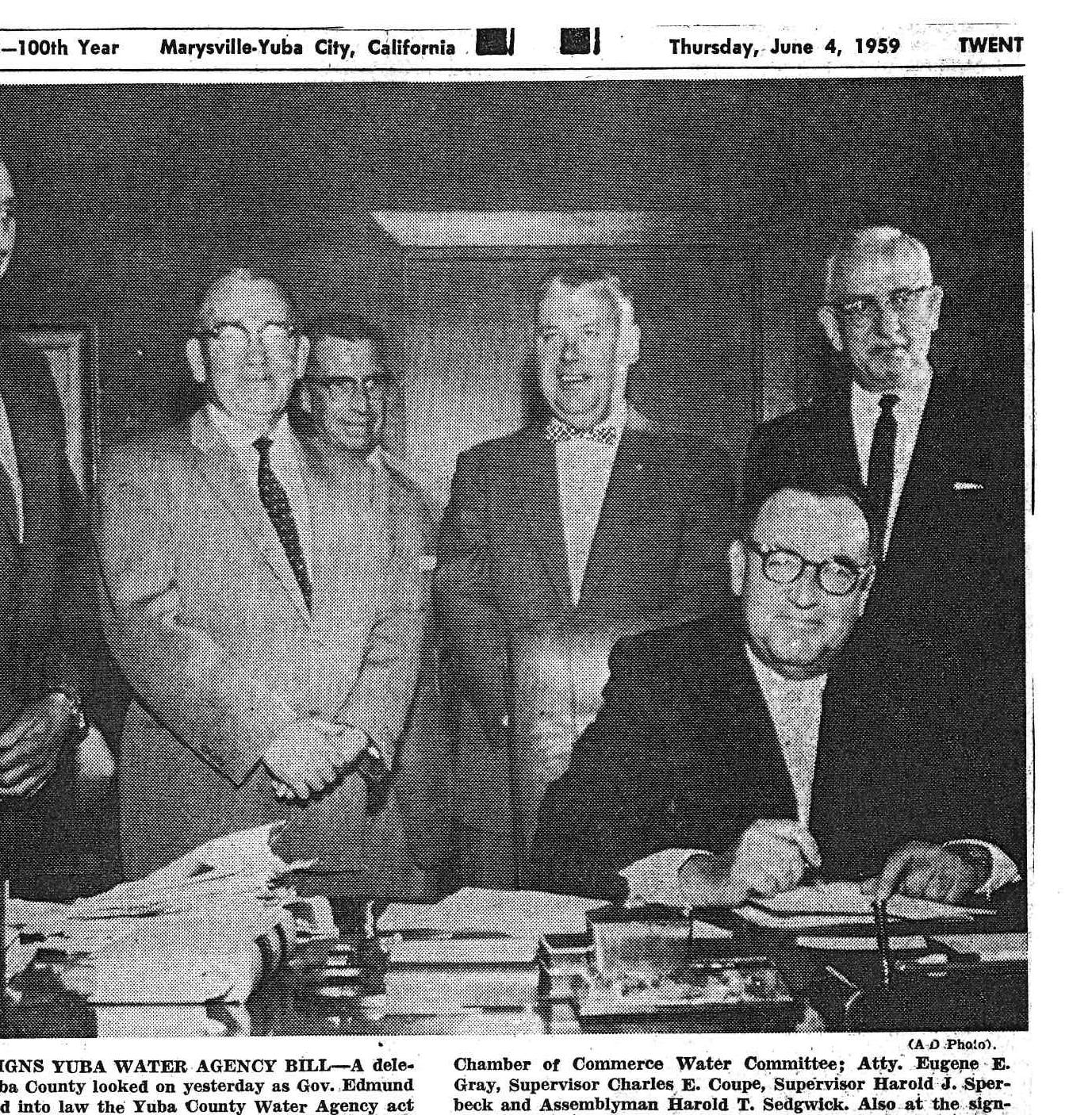
Governor Edmund G. Brown and Yuba County officials sign The Agency Act in 1959, creating Yuba Water Agency.
A HISTORY OF DEVASTATING FLOODS
BY
How and why Yuba Water Agency was created
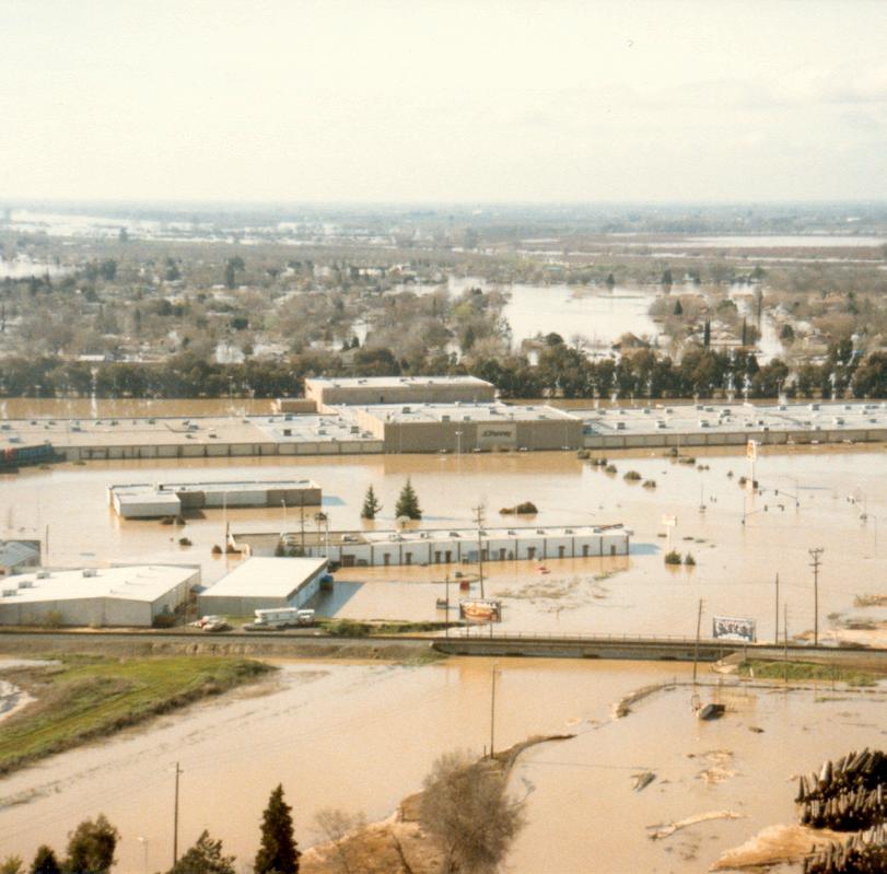
hen a Feather River levee collapse sent a wall of water into Yuba City on Christmas Eve 1955, it was considered the most severe natural disaster in California since the 1906 San Francisco earthquake. Starting December 18 and lasting for nine unrelenting days, torrential rain accompanied by high-speed wind drenched nearly 100,000 square miles. There were areas covered in 50 feet of water at times. The waters washed away railroads and highways, destroyed farmlands, submerged towns, drowned animals and overwhelmed thousands of homes.
The flood left 38 people dead, more than 4,000 injured and forced the evacuation of 40,000 residents from their homes. The cost of the damage was reported to amount to $100 million, equivalent to $3.4 billion in 2024.
CAUSES OF THE FLOOD—AND THE RESPONSE
A combination of factors led to the massive flooding of 1955. Hydraulic mining at the turn of the twentieth century eroded hillsides and altered waterways, making them less able to accommodate water flow and excessive sedimentation. Inadequate levee systems also increased flood risk.
In 1959, Yuba Water Agency was created to reduce the risk of future floods and maintain a reliable water supply for residents of Yuba County, which sits right across the Feather River from Yuba City.
Two years later, in 1961, Yuba County voters approved $185 million in revenue bonds to fund the Yuba River Development Project, which included construction of New Bullards Bar Dam and Reservoir, completed in 1970.
MORE FLOODING
The next major flood to hit the region occurred in 1986, when levee failures led to the destruction of thousands of homes, a major mall, killed two people and forced 26,000 residents to evacuate Linda, Olivehurst and Arboga (now known as Plumas Lake). Damage was estimated at $464 million. After the flood, government officials determined the levee system was in dire need of repair and improvement.
Before that work could be completed, however, a levee failure in Arboga caused another devastating flood in 1997, which claimed three lives and caused more than $1.8 billion in damage.
WHIP VILLARREAL
Left: The 1986 levee break on the Yuba River. Right: Flooding in February of 1986 essentially shuttered the Peach Tree Mall.
Local residents help sandbag flood waters following a levee break on the Feather River in neighboring Sutter County in 1955.
Flood waters inundate the 5th Street Bridge during the 1955 flood.
“We are definitely considering storms coming more frequently and potentially the magnitude being greater— and are constantly working on ways to reduce flood risk with those factors in mind.”
John James Director of Resource Planning, Yuba Water Agency
IMPACTS, AND INVESTMENTS
Ryan McNally, Director of Water Resources and Flood Risk Reduction for Yuba Water, says flooding has damaged the local economy more than anything else, beginning with the 1986 flood that devastated the community of Linda and effectively shuttered the thenthriving Peach Tree Mall. Those impacts were exacerbated by the 1997 event, which inundated the area now occupied by homes in Plumas Lake.
After the floods, many people left Yuba County never to return, McNally says—a further drag on the economy. This confirmed the need to implement major upgrades to the region’s levees, so from 1998, 1999 and 2000, significant projects were approved at both the state and federal levels.
These included $28 million from the U.S. Army Corps of Engineers for flood protection; the authorization by Congress of the Yuba River Basin Project to strengthen area levees; and the creation of the Yuba Feather Flood Protection Program, which provided nearly $90 million in state funds for levee improvements in the area managed by Reclamation District 784 in South Yuba County.
“The levees around the flood-prone areas in ’86 and ’97 have undergone significant improvements since those two floods,” says Willie Whittlesey, General Manager of Yuba Water Agency. “We are now at a level that is commonly called ‘200-year protection.’ But that name is misleading. It doesn’t mean a flood that happens only once every 200 years. The reality is these events can happen in any given year.
In addition to undergoing major improvements in recent decades, Yuba County levees have dedicated reclamation
to repair the
completely surrounds the City of Marysville and reduces flood risk for more than 12,000 people, the region’s largest and only level-3 trauma services hospital, two state highways and Union Pacific Railroad mainlines.
districts that keep up with routine maintenance and inspections. Thanks to these combined efforts, levees like those in South Yuba County are some of the most modern and updated in California.
“People should be confident that their risk is significantly reduced with all the work that’s gone into this,” Whittlesey says.
WORK—AND CONCERNS—REMAIN
Despite infrastructure improvements, other factors like climate change could cause more extreme weather events that can potentially produce major floods in the future.
“We are definitely considering storms coming more frequently and potentially the magnitude being greater—and are constantly working on ways to reduce flood risk with those factors in mind,” says John James, Director of Resource Planning at Yuba Water Agency. “We are always working on enhancing our operation’s decision-making tools and collaborating with academia and our partner agencies to improve atmospheric river forecasts to better predict when they will occur and how they impact our watershed.
“A project we are currently working on that is in the planning phase is building another spillway at our dam, with gates much lower in the dam, which would allow the release of more water ahead of a major storm.”
This and other future improvements will continue to reduce the risk of catastrophic flooding in Yuba County, which is the primary reason Yuba Water Agency was created all those years ago.
Work continues
7.6-mile-long Marysville Ring Levee, a levee that
Completed in 1970, the 645-foot tall New Bullards Bar Dam is the second tallest dam in California and the fifth tallest in the United States.
Yuba Water Agency partners with reclamation districts throughout the county to improve, inspect and maintain some of the most modern levees in the state of California.
THE RIGHT STUFF
BY KATHLEEN VIVALDI
Yuba Water Agency employees bring expertise, technology and personal experience to their mission
“It’s
In order to fulfill Yuba Water Agency’s responsibilities, the organization relies on a team of dedicated and talented individuals with unique skill sets and a collective commitment to the community.
For some employees, the work is personal. Ryan McNally, Director of Water Resources and Flood Risk Reduction, is a life-long Yuba resident who has himself experienced some of the area’s worst floods: “Over the past 40 years, I’ve evacuated from my Yuba County home three times from the threat of floodwaters—in 1986, 1997 and again in 2017,” says McNally. “It’s hard to find the words to describe the emotions surrounding your community being threatened by water and knowing that at any moment everyone’s livelihood might be lost.”
“To say those events shaped who I am today is an understatement. The fear of losing everything at a young age led to the passion I impart upon our team today.”
John James, Director of Resource Planning, oversees the agency’s Hydroelectric Project Licensing, Environmental and Watershed Departments, and Reservoir Operations. His background in meteorology helps implement improvement programs like the Forecast-Informed Reservoir Operations, also known as FIRO.
hard to find the words to describe the emotions surrounding your community being threatened by water and
knowing that at any moment everyone’s livelihood might be lost.”
Ryan McNally Director of Water Resources and Flood Risk Reduction,
Yuba Water Agency
By using some of the latest science and technologies related to forecast improvement, James says, “We keep track of everything—from how much snowfall there is in the mountains to how much water is flowing in the lower Yuba and Feather rivers.”
Karl Parker is the Operations Manager for Yuba Water, and his role is to direct and support the team of hydroelectric operators who operate the agency’s dams and powerhouses. Parker collaborates with the management team to ensure project operations support the agency’s missions at all times.
Managing flood flows is a complex operation, Parker explains. “There are seasonal limits to how
much water can be stored in New Bullards Bar, with the intent of leaving space to capture storm flows.” In addition, “there are limits that control the rate of change in our releases as well. We have a team at Yuba Water made up of expertise from multiple divisions in the agency. Public safety is always our highest priority.”
Parker adds, “I think it’s always good for people to understand that the team at Yuba Water Agency lives and works in our local community and we are all deeply committed to the mission and the community we serve.”
Looking downstream of New Bullards Bar Dam as Yuba Water releases water from the spillway during a winter storm.
How
YINFORMED AND PREPARED
BY RAUL CLEMENTS
Yuba Water Agency educates residents about flood risk
uba County was once described by the U.S. Army Corps of Engineers as being the “most prone to severe flooding of any river valley in the United States.” For this reason, it is vital that residents be informed of their personal flood risk. Fortunately, residents have several tools at their disposal to help them do that.
While there have been significant investments in infrastructure and technology, and Yuba County now has some of the most modern levees in the state, there is still risk.
“There is always the possibility that a storm could come along that is bigger than our systems were designed to handle,” says Sami Nall, Flood Risk Reduction Manager for Yuba Water Agency. “That’s why it is equally important that individuals be aware of their own flood risk.”
“Every area will have different flood sources, but in Yuba County, it’s primarily rivers or bypasses,” says Nall. “FEMA has a lot of resources that can help inform you what your risk is. The flood maps are probably the easiest because they’re visual and you can put in your address and see what type of flood plain you live in.”
“We are always looking at opportunities to reduce flood risk within the county.”
Sami Nall
Flood Risk Reduction Manager, Yuba Water Agency
Residents should also sign up for alert services such as CodeRED, a phone and email alert service run by the Yuba County Office of Emergency Services (OES). Nall also recommends following OES and Yuba Water Agency on social media. These social media accounts not only alert the public in the case of emergencies, but also educate residents on flood risks. Nall stresses the importance of being prepared in case of an evacuation notice.
preparation at the county’s “Be Prepared Fairs,” which Yuba Water partners and participates in. At these fairs and other community events, OES and Yuba Water are able to interact directly with the public and answer questions about flood risk.
Should flood damage happen, there are measures people can take to reduce the costs of repairs.
“Work with your insurance agent to see if flood insurance is right for you,” Nall says. “It might not be right for every single person, but it’s important to be informed about your options.”
The first step is knowing what your biggest flood source might be. For Yuba County residents, this means knowing where your closest river, creek or stream is. “Often individuals aren’t aware they live behind a levee,” says Nall. “It’s difficult to understand you are at risk for flooding if you aren’t even aware that that mound of dirt is a levee separating you from a fast-moving river.”
“Everyone should have a go-bag,” Nall says. “Work with your family to determine what your emergency plan is.” Residents can learn more about emergency
Yuba Water Flood Risk Reduction Manager Sami Nall discusses future opportunities to improve levee monitoring in Reclamation District 784 with University of California researchers and others.
Yuba Water’s director of water resources and flood risk reduction, Ryan McNally, educates residents in Plumas Lake about the agency’s efforts to reduce the risk of catastrophic flooding.
One gallon per person, per day.
To help you evacuate or shelter in place in the event of an emergency, collect enough of these nine essential items to last at least three days:
Enough non-perishable foods for each person (canned or packaged).
One change of clothes and shoes, per person. Other items depending on weather conditions: rain jacket, gloves, hat, scarf.
Prescription and other medications. Medical supplies and other equipment, including syringes, hearing aid, oxygen tank, inhaler or concentrator.
Basic items like soap, toothbrush, toothpaste, toilet paper, tissue, hand sanitizer, baby wipes and glasses or contact lenses.
A first aid kit, emergency blanket, whistle, plastic trash bags, paper towels and household bleach (to sterilize items as needed).
Cell phone with charger or portable battery, chargers for other electronics, extra batteries, flashlight and radio. Other Items: laptop, tablet, hard drive back-up.
*Other Items to Consider:
• Additional emergency kits to keep in common places (home, car, workplace, on-the-go)
• Full tank of gas for vehicles (reccomended to fill-up at half tank of gas)
• Pet supplies (food and water, leash, carrier, medicine and medical records, a photo of your pet, bowls, litter box, grooming items and toys)
Extra cash, spare sets of keys, manual can opener, local maps and multipurpose tool (acts as a knife, pliers and screwdriver).
Copies of emergency contacts, photo IDs, SSN, insurance and immunization cards, insurance policies, financial records, property records, vital medical information and other important documents (wills, trusts, deeds, certificates).