4 minute read
MAPPING BAMPTON A journey in Space and Time


By Will Fenton

Advertisement

MAPPING BAMPTON: A JOURNEY IN SPACE AND TIME
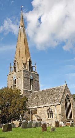
From whichever direction you approach Bampton, it never fails to present itself in the most startling manner. Defying the low-lying and broadly featureless modern agricultural landscape, a traveller is somehow still unexpectedly confronted with the sudden appearance against the horizon of the darting spire of the Church of St. Mary, topped by a golden cockerel that when observed at the right time of the day reflects the sun with the intensity of a fiery beacon. It is an enormously evocative sight; a warming comfort to those who know this to be a return home, and simultaneously the shining lure to those who have the privilege of visiting Bampton for the first time. To witness the steeple of the Church of St. Mary, at dusk or dawn, inevitably draws any visitor straight to what many would consider the heart of the village. No stranger would ever need the help of a Downton Abbey tour guide to arrive at this spot.
In my view what is most striking about this experience is how Bampton, even though connected today by all modern convenience to nearby towns and cities, feels somehow still isolated. It is a place waiting to be chanced upon. ‘Bampton-In-The-Bush’ is of course the not-sotraditional full name for the settlement but is one that feels ancient enough in 2023 to feel entirely appropriate.
Writing in 1853, the wildly eccentric vicar and historian of Bampton, Rev. Giles reflected on the difficulties of travelling out from Bampton to other towns “due to the nature of the country”. He recorded in his determinedly colourful fashion that within living memory there were no metalled roads leading from Bampton and that travellers were in the habit of “striking out across the common, by which the town was surrounded, and finding their way to Witney, Burford, Oxford or any other place in the best way they could, as is done to this very day in the deserts of Arabia and Africa”. While the modern traveller does not have to endure such hardships, I often reflect on his words when I strike out on public footpaths that radiate from Bampton, looking back over my shoulder at the slowly diminishing spire of St Mary’s silhouetted against huge skies. These paths are undoubtedly the fossilised remnants of the ancient paths taken by previous generations of Bamptonians to escape the ‘bush’, to work the fields, or to cross the barrier of the River Thames.
This is a good point at which to introduce the purpose of this book. Mapping of all data can be used to examine the historic and archaeological processes which have shaped the modern landscape in and around Bampton. The study of maps allows us to identify the specific characteristics of an area or district, so that we can understand what makes our town distinct. On a basic level this should challenge us all to value what makes Bampton special. But it also serves a very important purpose of allowing us all to have a stake in ensuring our historic town and landscape is managed appropriately.
To do this, we must recognise that all parts of the landscape – from the Iron Age barrow to the 2023 housing development – have historic value and they must make an equally important contribution to the landscape in which we live and share. Only in this way we can be strengthened the welcoming little community that we have built for ourselves here.
As such, this book will be limited in scope. It is not intended to re-tell a conventional history of Bampton with the simple addition of some attractive maps. Bampton has attracted antiquarian interest since the 17th Century, and much better historians than I, have written good histories of various aspects of the settlement’s history. Instead we will use map evidence (with some supplementary sources such as aerial imagery, archaeological data sets, and other topographical data) to characterise modern Bampton by placing the town in its historical context. We will largely be confined to considering
MAPPING BAMPTON: A JOURNEY IN SPACE AND TIME
the settlement of Bampton and its immediate environs, but reference will be made to the settlements of Aston, Lew, Cote and others where it is important to recognise their historic or ecclesiastical connection to Bampton.
I also hope this book can serve in some small way as a record of the very simple techniques accessible to 21st Century researchers for assessing historic landscapes and an opportunity to highlight some of the resources that are freely available to those interested in conducting their own research. In the 21st Century older data sources are increasingly being digitised and all new sources are created digitally from the outset. Increasingly, the data we collect about the historic environment is being made accessible using Geographical Information Systems (GIS) that create, manage, analyse, and map all types of data from the simple crop mark to recently described conservation area. Do you know where otters have been spotted near Bampton? There’s a data set for that! The great irony, of course, is that it is arguably becoming less useful to reproduce heritage data such as historic maps or aerial surveys in the ‘static’ format such as this book and exhibition. So if you find your home or the site of your interest is cropped slightly out of the frame, I can only apologise!

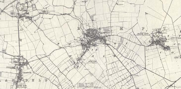
1 BAMPTON IN ITS LANDSCAPE:
Bampton is situated in a predominantly rural area of West Oxfordshire; an area characterised by agricultural enclosures, small rural settlement and minimal woodland. In a 1998 Landscape Characterisation study ‘Bampton Vale’ was identified and classified as “an area of distinctly low-lying but gently rolling clay vale between an edge of Limestone to the North and the expansive floodplain landscape which borders the River Thames to the south. The underlying clay geology is reflected in the soils and character of vegetation (oak being the dominant tree species).
Taking our first image, a modern aerial photograph of Bampton, we can immediately identify a landscape of large fields, bounded by a reasonably strong structure of trees and hedgerows. It is interesting to note that these enclosures are not, unlike those only a few kilometres to the north, bounded in stone walling. Large agricultural enclosures are the most common land use in West Oxfordshire, accounting for 77.5% of the district, and that pattern is evident here. Modern air photography shows a degree of weakening of landscape structure through intensive farming practices, particularly to the North of Bampton.


