
14 minute read
MAPPING BAMPTON: A JOURNEY IN SPACE AND TIME


The exercise was so successful that it was repeated throughout the 20th Century for much the same reasons (topographical survey, calculating land use, town planning, road building, even traffic management). For a long time these images were carefully restricted for domestic use- in the atmosphere of the Cold War they were naively considered be a ‘gift’ for the enemy without any recognition that the USSR had been carefully mapping the UK since 1950. By the later 1980s the vast collection of images was turned over to the government body that now, as Historic England, hold the collection. The collections are now publicly available and an increasing number of images are now freely available online.
Luckily, this means we have a comprehensive set of aerial surveys that in some ways are more valuable than the revised post-war Ordnance Survey maps that replaced them. They hold great value for those interested in a contemporary snapshot of the landscape, and they continue to have a great value for those researching landscape history. They show features that maps do not, including land use, field boundaries, and of course, archaeological features. As a resource for understanding rapidly changing post-war rural economies these images deserve to be taken seriously as an additional source of information to
Advertisement
MAPPING BAMPTON: A JOURNEY IN SPACE AND TIME
be examined in association with the maps made for the National Farm Survey 1941-43.
Studying the photograph included here of Bampton in 1946 one is tempted to immediately attempt to spot the differences to the modern air photo presented above. But before we do, we must confront the fact that at first inspection it is the continuity of which settlement patterns are striking.
Within a month of the RAF photo reconnaissance (PR) overflight of Bampton a very terrestrial piece appeared in Country Life’s “Old Towns Revisited” series. It is worth quoting the correspondence’s description of Bampton as it presented itself to themselves at some length:
“Bampton’s streets are lined with modest stone-built houses, some of them still stone slated. At the junction of the three ways stands the early Victorian town hall or market hall, built on arches, too late, one would think to serve any very useful purpose for a market that had already decayed. The wide market place would look better if some grass and trees were introduced, as along Broad Street leading north, where the cottages lie back behind grass verges planted with limes. In the north-west segment of the town stands the church and an interesting group of houses disposed around it in a manner of a cathedral close. Bampton is remarkable for its number of substantial stone houses, each standing in their own grounds.”
Had the author been able to return in 2023 he may not have needed to amend his description of the central core of Bampton all that much! Looking more closely at the 1946 aerial photograph there is indeed little in the way of change over the last 80 years. There are some infill developments discernible in a number of places (particularly at Bushey Row, Castle View and to the north of Rosemary Lane), but on the whole the spatial relationships in this part of Bampton have remained static throughout the later 20th Century and into the 21st Century. The settlement in 2023 retains a loosely knit character, and there is still a discernible sense of houses clustering around their own centres of gravity. Good examples include the southernmost part of Queen Street, the part of Church View that opens on to the churchyard, the corner of Weald Street/ Primrose Lane, the cottages clustered around the south of Sandford Field, and the houses clustering around Mill Green. The latter two examples, even in 2023 do not (and arguably cannot) have direct vehicular access.
The central core may remain largely unchanged, but outside this area the story is altogether quite different. In 1946 new residential development in Bampton has barely escaped from the historic core. The most notable additions to the town in the first half of the 20th century were mainly limited to individual developments or direct replacements. The most significant of these perhaps being the rapid expansion of the house known as The Grange.
MAPPING BAMPTON: A JOURNEY IN SPACE AND TIME
This house, based around the core of a rather modest 17th Century or 18th Century farmhouse was extensively remodelled and extended in a very accomplished manner throughout the first quarter of the 20th century. Complementary to the development of the house, the land between the Grange and the Shillbrook to the south was also modelled as miniature parkland- a character that this area retains to this day. A few other notable buildings were reconstructed in the early
20th Century on their existing sites, perhaps the most obvious example in Bampton is the Horseshoe Public House, where a new building replaced a 17th Century structure in c.1925 after a devastating fire. The loss of a 17th Century inn may be lamented, but the replacement structure that exists to this day is a neat and considered design that remains an asset to Bampton’s architectural milieu.
Other early 20th Century century expansions of Bampton were pre-war council housing, the continuation of which may have been curtailed by the war, or may indeed have been slowed by the population decline in Bampton during the early 20th Century that obviated the demand to rehouse urban populations in rural service centres. Either way, by 1946 new developments are largely confined to small estates north of New Road and between Bushey Row and Beam Cottage. The result of these modest changes is that in 1946 Bampton was largely confined to its historic core, and as a consequence was still surrounded by historic enclosures used for the purposes of either agriculture or small-scale horticulture. The latter is very evident on the 1946 aerial photograph (see page 11) in the area to south of New Road. The same area is identified specifically as “allotment gardens” on the first post-war revision of the
OS 1:10000 ‘National Grid’ map. In the wider landscape, there is very little change to note, other than first visual record of the Royal Corp of Signals (Army) base which was constructed on a low rise of land to the south of Weald in 1939. (It did not become RAF Bampton Castle until it was transferred to that service in 1969). This is now the site of Bampton Business Centre.
MAPPING BAMPTON: A JOURNEY IN SPACE AND TIME
By the first major revision to post war mapping, conducted here in 1956, little has changed. The new building along New Road has expanded to the North, but very little other building can be noted. Perhaps the most noteworthy individual development is the construction sometime before 1959 of a neatly modern but otherwise typically modest vicarage within the curtilage of its
17th Century ancestor. It is worth noting that national constraints on government resources meant only ‘major’ revisions were made to this series of Ordnance Survey map.
The reader should exercise some caution using this generation of mapping to identify more subtle changes to individual buildings and sites.
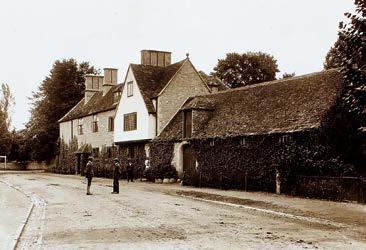
Royal Corp of Signals, Weald, later to become RAF Bampton Castle
It was not until the 1960s that the issue of managing the future development of Bampton was considered seriously and systematically. In 1966 the Oxfordshire County Surveyor was commissioned to report on the character of Bampton with a view to recommending the nature and scale of development that may be appropriate. The author described very much the same as the correspondent for Country Life had almost two decades earlier: “an attractive limestone-built town with a market square and town hall. The three facades to the main roads are predominantly Georgian…”. The planner then went on to dilute his praise by noting what he considered the encumbrances of the present age viz: “…spoilt in a few places by untidy advertisements and disproportionate shop fronts.”. Such a statement indicates a strengthening of antiquarian attitudes about how an “old” town should present itself.

In this reading of Bampton’s history the implication is that ‘ancient’ and ‘modern’ have strictly defined meanings, and therefore there is an equally distinct hierarchy of historic value. This interpretation can be exploded immediately. Who among those that remember Bampton in 1966 recall a town without remembering the shop signs, “disproportionate shop fronts” or a proliferation of pasted advertising posters?
Nevertheless the County Planning exercise went on to codify the principle that the historic core of Bampton should be carefully preserved and future development limited; perhaps the first time this principle entered official local government policy even if it had been tacitly accepted since at least Rev Giles’ time a century earlier.
More interestingly, the 1966 exercise was concerned with the future of development in Bampton. This was adjudged to be driven in a small part by a recent increase in population attributed to the deployment of long-term residences of the service personal and their families to the Royal Signals Base in Weald. It is of note that the report also, even at this late date refers to the “tortuous” road routes out of Bampton echoing some of the constraints on development that had existed by this point
MAPPING BAMPTON: A JOURNEY IN SPACE AND TIME
for centuries. The report concluded that large scale expansion was impractical, undesirable, and in the context of rapid development in the nearby military settlement of Carterton, totally unnecessary. The final recommendation was that future building should remain confined to the area bounded by New Road, Aston Road and Mount Owen Road. It was assumed infill development would eventually fill the area between Bushey Row and Broad Street should a developer come forward with a “comprehensive” scheme that allowed access by modern motor vehicles. Consideration was given to further development along Weald Street, but rejected on grounds of practicality rather than concerns that any intensive development in this ancient township may have broken the very different rhythm of historic settlement along this strung-out and presumably very ancient linear settlement.
I have described this report in such detail since, broadly speaking, it set the trajectory for over a half-century of development in Bampton. In 2023 the County Surveyor’s approach would be considered ruthlessly pragmatic. A historian of 2023 could legitimately conclude that Bampton escaped further constraining development simply because the local economy could not sustain it, but such a conclusion would be unfair. The 1966 report is more nuanced than those produced by contemporary town planning practitioners throughout England. A direct line can be drawn from this report to the eventual designation of the historic core of Bampton and Weald as a conservation area and, of course, to the recent discourses to determine the location and shape of modern residential development in the NE Bampton.
Before we address these very contentious issues, it remains to acknowledge that the attempt at historic area characterisation in 1966 was perfunctory by modern standards. The report still relied on the broadly antiquarian approach of valuing aesthetic or architectural value to identify the ‘historic’ core of Bampton. The part of the settlement deemed ‘worthy’ of preserving was still defined by people who understood heritage value in this constraining manner. This was an application that inevitably valued Bampton’s built heritage considerably above that of the wider landscape, and certainly was not sufficiently sophisticated to properly consider the significance of historic land use patterns, settlement densities, and the spatial relationships between settlements and their hinterlands. In less lucky settlements of Oxfordshire this thinking led to many settlements having their historic cores conserved only to find
MAPPING BAMPTON: A JOURNEY IN SPACE AND TIME
them subsequently chocked by a ring of insensitive mid-20th Century development. Perhaps Bampton owes a lucky escape from this fate to its relative isolation and commensurate low demand for housing in the 1960s?
It is also of note that Bampton’s first comprehensive neighbourhood planning exercise was conducted at a time that the concept of Conservation Areas had first been seriously mooted. Hargreaves (1968) argued that area designations were the response to protecting and managing historic landscapes. The first Conservation areas were designated in 1967 and Bampton was itself designated a conservation area in 1976. [see map opposite].
Successive West Oxfordshire District Council Local Plans were periodically conducted throughout the later 20th century, although not without each having to negotiate their own controversies when applied to the situation in Bampton.
The next major planning exercise was conducted in the later 1970s. It was both more sophisticated and more holistic in its approach, demonstrating the increasing significance of Local Planning for managing change in rural communities. A much greater attempt was made to focus on historic area characterisation and much more effort was made to engage the community to help the local planners understand attitudes to change. Planning in the 1980s was looking forward to the middle 1990s, and anticipated increased residential development. Alongside this,
Bampton Parish Council conducted an exercise in community consultation. Their terms of reference tells us how the nature of change was perceived in Bampton, which appears to indicate a sense of trepidation:
“During 1982 it became apparent that Bampton was on the verge of fundamental changes: a great deal of new speculative housing development was in the offing and at the same time many shops were closing. An increasing proportion of the community was “new” and the Parish Council felt it could not speak for the community and represent its interests without greater knowledge of what the community actually thought about imminent changes and wanted from them. More or less development? More or less employment? To emphasise tourism and crafts or to go for growth and more industry?”
The document also gave insight into attitudes towards the recently designated conservation area, with only 70% supporting the areadesignation. A sizeable minority thought only “all stone buildings” should be protected, and other smaller minorities felt protection should be limited to various specific asset types such as “the large old houses”, “the Grammar School”, “all the pubs” or specific areas such as “The open space of Mill Green”. These responses demonstrated local attitudes to what was considered the essence of the historic significance of Bampton, and as could be expected, is largely traditional reading of what constitutes heritage significance.
MAPPING BAMPTON: A JOURNEY IN SPACE AND TIME

Successive developments to the North East of Bampton remained largely bounded by the area first identified in 1966. As the 1980s progressed, the area between New Road, Aston Road and Mount Owen Road became fully developed. Each development exhibits its own subtle settlement patterns that reflect contemporary spatial planning practices: The grid-like patterns of Bowling Green Close contrast strongly with the more sinuous patterns of Calais Dene.
As local planning policies developed, so did national planning policies. The government of the day has long been obsessed with the concept of ‘place making’ as they try to balance the competing priorities of providing the necessary numbers of new houses with the needs of local communities. This struggle has been played out as a delicate political dance in West Oxfordshire for many decades. By the 2000s the overall emphasis on speed and quantity of housing supply appeared to threaten the idea of making communities people actually wanted to live in, along with raising real questions about sustainable development for the long-term and the delivery of high quality and design standards. The proliferation of national and local planning policy had also created a bewilderingly complicated system. In 2012 the government, to much fanfare, produced the National Planning Policy Framework (NPPF), which, it claimed would reduce 1000s of pages of planning policy down to 55. It did. But importantly for the story of Bampton, it also embedded the idea of ‘place making’ in spatial planning. Place making is more than building houses. It is about building places and resilient communities that are connected to their services and infrastructure. In real terms this was supposed to mean the planning system was to become more integrative and make the connections between places to live, learn, work and play.
How did this play out in Bampton? Two major developments have occurred since the NPPF was introduced. That to the North of New Road (2015), and that to East of Mount Owen Road (2022-). I will take no view on how these schemes ultimately embraced the principles outlined above, but in terms of mapping, they certainly exhibit different settlement patterns to earlier residential developments. It is to be commended that the Bampton Community Archive have taken such a keen interest in collecting media and planning documents relating to these schemes. They will be important resources for future historians.
West Oxfordshire District Council currently has a Local Plan that anticipates development needs
MAPPING BAMPTON: A JOURNEY IN SPACE AND TIME
to 2031. It is currently working on an update to 2041. Bampton remains defined as a rural service centre, and “Whilst not within the Area Of Natural Beauty (AONB), Bampton [has] a more restricted range of services and facilities. As such, more modest levels of development are anticipated in [this] rural service centre to help reinforce [its] existing roles.”.
Also visible on mapping, and in aerial photographs is some of the more informal 20th Century settlement in Weald. There are a number of Travellers, and Travelling Show people families living in West Oxfordshire on a range of specifically approved sites throughout the District and also in bricks and mortar. Modern strategic planning has a role to play in facilitating the way of life for travellers, not least in ensuring there are appropriate sites, in suitable locations, available to meet their needs and, from which they can access education, health, welfare and employment infrastructure. No appreciation of Bampton’s development through time could be complete without adequate reference to the longstanding private authorised Travellers site at The Paddocks, Weald.
Other informal settlement patterns that have become established landscape features can be found to the south of Primrose Lane, Weald, where the development of St Mary’s Court as a caravan site established in 1961 and visible on the 1970 aerial photographs of the area.
Judging solely on stylistic grounds perhaps I was witness to one of the last remaining homes dating to the site’s inception being finally and lamentably removed in 2022 without any concerted effort to record its passing. The brutal process of the destruction of a structure, no matter how insignificant invites the reader to reflect on the nature of change as it is experienced in the moment. Today it is acknowledged that “Thatched Cottage”, “Bell Cottage”, or “Knapp’s Farmhouse” may justifiably claim to be some of the earliest examples of vernacular architecture in Bampton, each containing evidence of early open-hall cruck frame construction, but at one time were surely viewed as common (and yes, I do mean that pejoratively) as any other unreformed ‘country-built’ house in the settlement. Did the people of Bampton in the 19th Century realise how close they were to losing the final handful of buildings that would allow future generations to understand their ancient settlement? While the modern conservation movement was driven forward in the late nineteenth century by William Morris and the Society for The Protection of
MAPPING BAMPTON: A JOURNEY IN SPACE AND TIME

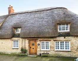
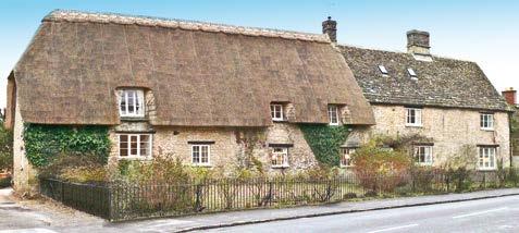
Ancient Buildings (SPAB), many vernacular historic buildings continued to be lost well in to the 20th century. The three remarkably early survivals in Bampton escaped that fate only by chance. Indeed, while they would have enjoyed a measure of protection by virtue of being situated within the Bampton Conservation Area, those three examples mentioned above were only given their own unique statutory protections (through listing) in 1982, 1989 and 2001 respectively.
The modern settlement of St Mary’s Court has a distinct nucleated character, mirroring contemporary ‘out and back’ design practices commonly seen in “bricks and mortar” residential developments of the post war period (by way of comparison this perhaps best manifested in Bampton by early post war developments such as Fox Close). This style of residential design was one of the first to assume residents’ car ownership when determining layout. The settlement is made up of structures that throughout the 20th and 21st centuries became increasingly permanent in nature, many with brick or concrete plinths and pitched tiled roofs. Such a site, like the Travellers site at the Paddocks represents an important, but under-represented history of the settlement in Bampton and allows the historian to understand the changing nature of rural labour in later 20th century West Oxfordshire. Agriculture, industry and indeed, tourism/hospitality in West Oxfordshire have all utilised seasonal or transitional labour. The residential provision for the agile economic models of the later 20th and early 21st century is a little understood and is often marginalised in the story of the places in which we live. There is a tendency to consider rural populations as largely static. This has never been the case, and it is certainly not how modern rural economies function. In the context of the present study we are invited to reflect on the value to historians of formal mapping when studying informal settlement patterns.


