
15 minute read
Perpetual Leases over Māori Land


Mick Strack
The issue of perpetual leases over Māori land is now being challenged by the Green Party in Parliament. They describe the arrangements as a thinly disguised system of land grab, and state:
Advertisement
“Māori landowners have had no direct say in who leased the land, what the rent should be, or what the land would be used for.” What are perpetual leases, why were they established and how do they work?
Prior to the Treaty of Waitangi, there was uncertainty about what Māori may have been selling; whether it was just a right to occupy the land alongside the customary owners such that the whānau or hapū retained control over the land and occupation was at the grace and favour of the chiefs. In any event, there was no English law established that could provide protection of any acquisition of land by settlers, and when Captain Hobson arrived in NSW in 1839 he declared all previous ‘purchases’ void, and then set up the Land Claims Commission to investigate those early land dealings, and to offer an English-style land grant to recognise legitimate and good faith purchases.
After the Treaty of Waitangi, when the Crown was busily acquiring Māori land for grant to the settlers, there was little debate about the required property rights. A full fee simple title issued to an individual was seen as the only way to acquire complete and secure property rights; fee simple title provided security of tenure. However, by the last quarter of the 19th century, in an effort to get more settlers established on small holdings, the government wanted to provide additional incentives for farmers to settle on the land. Various forms of leases and grazing licences were tried and then perpetual leases were created by the Land Act 1882 for a 30-year period with a further 20-year right of renewal.
While most of these leases were created over Crown Land, many were created over land that the Crown had reserved for Māori, or were parcels returned to Māori after the confiscations of the 1860s. It was presumably thought that by creating a lease over Māori land, then Māori would retain some control over the land, retain some property rights, some decision-making ability, some regular income, and the possibility of resuming the land in a reasonably near future. But in fact, they were a device to further remove Māori control over the land.
A perpetual lease is usually established as a lease for 21 years with a regular review and right of renewal after that time. Typically, there is an annual rental fee of 5% of the land value (capital value less the value of improvements). There are several benefits to leaseholders in such arrangements: purchase prices of the lease should be significantly less than a purchase of a fee simple estate; the relatively low annual rent should still allow for a reasonable profit to be made from production off the land; the leases including the improvements can be sold at a good profit; commitment to the land can be temporary. On the other hand, some restrictions come with these leases: the lessor can impose conditions on land use, there may be responsibilities and expectations to keep the land weed and pest free; and initially, for leases from the Crown, there was a requirement to clear the bush and drain the swamps – i.e. alter the land significantly for its productive values rather than retain the land’s natural values.
It was previously supposed that retention of Māori land may be effected by creating marketable leases rather than selling the fee simple title. However, when these leases were made perpetually renewable, any practical interest that Māori may have in the land was lost as the lessees acquired an almost complete property right. These perpetual leases amount to a complete loss of Māori control over this land – just one more way to undermine Māori interests in the land. Now many perpetual leases of Māori land are held and managed by the Office of the Māori Trustee.
The Māori Trustee position was first established in 1920 as the role of the Native Land Court was changing from alienation to better management of Māori land. The trustee’s purpose was to assist Māori in managing their land for productive purposes. Later, in the 1950s, the Māori Trustee was empowered to acquire small and uneconomic parcels and shares in Māori land, again to assist with better management.
Under the current arrangements, with no prospect of Māori being able to realise the economic value of this land, nor of being able to restore their customary relationships with the land, the land provides minimal benefit for Māori. The Crown has demonstrated that legislation can be passed to extinguish perpetual leases, and the Crown has been relatively active in restoring Crown land to Māori through the Waitangi Tribunal processes, so it seems that dealing with these leases would provide some very useful benefits for iwi.
The Crown pastoral leases of the South Island High Country suitably illustrate the attributes of land use restriction and the values held in a lease. The pastoral lessees are restricted in their land use (to grazing sheep and cattle), but recently as the Crown bought out these leases, very high purchase prices were paid by the Crown to extinguish the lease and regain the land as public conservation estate.

As an indication of the property rights attaching to a lease, a case was brought against a High Country station (Crown Lands v Minaret Station 2009). The case was largely about the rental valuation but there was also discussion about the nature of the property right in a perpetual lease. The court stated: “Those rights approximate those of the owner of the full bundle of property rights associated with ownership of the fee simple estate except for a requirement to pay rent and the imposition of restrictions on activities that may be undertaken on the land” (Minaret at [96]). And in another case brought to question the property rights of a Pastoral lease, the judge stated: “The very purpose of these leases is to alienate the land from the Crown, but in circumstances that limit the type of activity that may be carried out on the land” (NZ Fish & Game Council v AG 2009 at [82]).
The process of extinguishing the leases and/or converting the lease to freehold required a special act of Parliament (the Crown Pastoral Lands Act 1998), and considerable administration costs in assessing the land values, negotiating with stakeholders, surveying the parcels, and registering new interests. That process was flawed in numerous ways, and subject to much criticism; especially with the interference by the Crown of legitimate property rights, and the subsequent generosity of the Crown to the affected lessees – the very high purchase prices.

The registered property rights of a perpetual lease have significant protections in law, so the extinguishment of these leases over Māori land will need legislative support. The regular rent and conditions reviews provide an appropriate time to negotiate the extinguishment of the right of renewal. This would give lessees appropriate notice about the removal of their property rights and time to negotiate exit conditions (including compensation for improvements).
The perpetual leases over Māori land amount to 26,000 hectares – only 0.1% of the land area of Aotearoa. It would seem that more serious issues attach to most Māori freehold land (about 5% of the country). These issues include the difficulties of land use decisions on multiply owned land that affect production, occupation, and cultural relationships. The process of repealing or amending Te Ture Whenua Māori Act 1993 has stalled, but much could be gained by addressing the problems of Māori land use and management in new legislation. •

The Measure of the Man Reviewed by Ross Miller FNZIS

Don McKay, FNZIS, has clearly chosen as his retirement job the recording of the life of one of the most illustrious and important surveyors New Zealand has ever had – Archie Bogle. Don was not satisfied that such an important figure was marked only by an Institute award named after him and an anecdotal autobiography Bogle wrote over 50 years ago – Links in the Chain. Don had earlier penned an ‘article’ entitled Surveyor Extraordinaire which was a short biography in which he traced Archie’s career and achievements in the many positions he held.
I reviewed that article and expressed my concern as to what its future was as it was too short for a book and too long to be printed in an pages on good quality paper. It is broken into the three parts covering the above 3 aspects plus introductions and prefaces, a bibliography, a glossary of terms and an index. The book has many photographs that were originally black and white but many have now been coloured which enhances them considerably and adds to the feeling of quality in the book. There is also a useful map of the Whanganui River basin where Archie undertook the majority of his work.
A great majority of the text is made up Archie’s writings, he was a very good and prolific writer and cover a multitude of subjects. His writing style is easy; it can sometimes be light-hearted, sometime serious and sometime thoughtful (his 1935 Anzac address at Maxwell, p189, is a case in point). Through these writings and anecdotes we really do get the measure of the man. Don and his team have certainly achieved what they set out to do and should be congratulated for that. They obviously had a huge number of decisions to make in producing this book, I am not sure they got them all right but that does not distract from the overall attractiveness and readability of the book. This book will be a must for those who have not only an interest in the history of New Zealand surveying and surveyors but also the country’s early history. I can thoroughly recommend it. Any proceeds from the book will be going to the Kairūri Community Trust which was established by the Institute in 2017.

The Measure of the Man
Compiled by Don MacKay, Andrew Blackman, Gordon Andreassend
ISBN 978-0-473-66132-8
Book Production – PressGang
This is a book with its own Mana, a quality hardcover production in full colour, well-illustrated, elegant size (a little less than A4), very suitable for a coffee table/reception table and a great read. A book that will enhance our profession and the Institute and likely become a collectors’ item.
A book that has everything: part autobiographic, part biographic and part anecdotal, clearly illustrating why this man was undoubtedly surveyor of the century. The Foreword to this second enlarged edition is written by Bill Robertson.
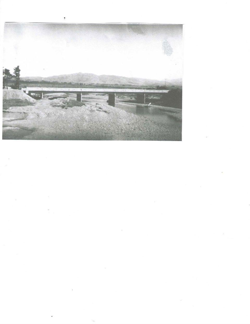
From Chapter 35 – Notable Commissions and Projects carried out by Archie.
During his career Archie carried out several unusual or notable jobs. Some of these are mentioned by Archie in Part One, some in Part Two. They varied dramatically from a magnetic survey of the North Island to bridge building to land developing and probably his last large job, the fourmonth contract to the Samoan government at the age of 73. We detail four of these jobs.
This book is dedicated to Archie, a tribute to his memory as one of our greatest sons on the occasion of the 50th anniversary of his death.
It is attractively priced for S+SNZ members at substantially less than retail and supports the Institute charitable arm, The Kairūri Community Trust.
The Bogle Reprint Committee and Editors Gordon Andreassend, Andrew Blackman and Don McKay.
How To Order
If you wish to purchase a copy or copies and are a NZ resident NZIS member please go to our website www.surveyspatialnz. org and complete the order form.


Advice Notes
1. The cost is $40 per copy inc GST plus P&P and credit card fee, at cost, $12. Delivered by courier in a protected envelope.
2. If you are a donor to the Trust as a result of earlier appeals, please ignore this invitation (unless you want further copies). Your complimentary copy is already reserved.
3. If you would like to purchase in bulk, boxes of 12 at a discounted price of $380 each plus GST and delivery please email Andrew andyblackman17@gmail.com
4. This invitation applies to NZ resident members. For those overseas members please email Andrew as above (unless you have already donated as above). Postage varies considerably country to country.
5. The GST amount on each purchase of $52 – is $6.61, and delivery April 2023.
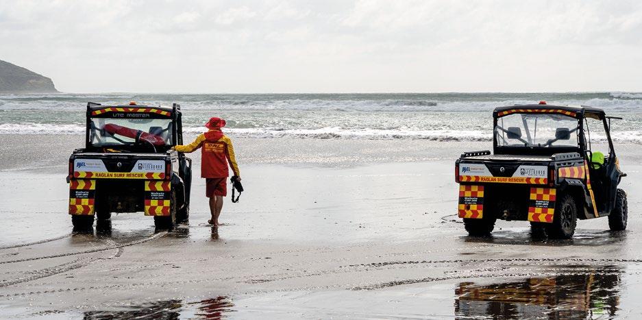
BEACHGOERS COULD BE SAFER THANKS TO A NEW TECHNOLOGY WITH THE POTENTIAL TO GIVE REAL-TIME UPDATES OF RIP CURRENTS
NIWA
Rip currents are narrow, fast-moving segments of water that travel away from the shore. They can reach speeds of 2.5 metres per second, which is quicker than the fastest Olympic swimmer.
NIWA and Surf Life Saving New Zealand (SLSNZ) have developed a state-of-the-art rip current identification tool using artificial intelligence (AI) and deep learning. The tool showed around 90% accuracy detecting rip currents in videos and images in trials. The work is published in the journal Remote Sensing

NIWA coastal scientists Dr Christo Rautenbach and Neelesh Rampal say the technology has been tested on a large variety of images from different coastal settings and they hope will ultimately be used by beachgoers to alert them of rip currents.
“We hope that by using cameras and drones at beaches, the tool will be able to scan video footage and notify people of the presence of rip currents. Even knowledgeable surf lifeguards can struggle identifying rips, depending on the beach and environmental conditions. As well as this, some beaches are remote or really large, so surf lifeguards can use all the extra help they can get!” said Dr Rautenbach.
The technology was developed by feeding millions of coastal aerial images into the AI model, along with artificial rain and fog data, to teach it to identify where rips occur in real-time, regardless of weather conditions and camera angle.
The “warmer” colours are where the AI is focusing – it gives a probability score that shows, with various confidence, that a potentially deadly rip current is in that area. [NIWA]
Adam Wooler, Special Projects Manager at SLSNZ, says once operationalised the technology will be invaluable for people while they’re out enjoying our beautiful coastline.
“This is only the beginning of our research together and our goal is to build even more effective, accurate and reliable safety tools for New Zealand beaches. Rip currents can sweep even the strongest swimmers out to sea – we had 90 people sadly drown in New Zealand last year, 25 of them on beaches, so we’re hoping that this technology helps to significantly reduce that number,” said Wooler.
Rip currents are reported as the most hazardous safety risk to beachgoers around the world. An Australian study published in 2013 revealed that they have killed more people on Australian territory than bushfires, floods, cyclones, and shark attacks combined.
Hydrographic Stream Update
Stuart Caie, Chair, Hydrographic Stream Ocean Infinity (OI) is busy gearing up for the next phase of the HS73 and HS74 Hydrographic Survey, in the Tasman and Western Marlborough Sounds region.
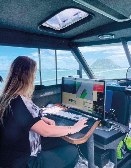
This survey follows on from the previous 2022 survey in the same region, but it will shift focus to the offshore areas of the survey, approximately 12,000 nautical miles. This includes Farewell Spit to Kahurangi Shoals (West Coast, near Karamea), approaches to Nelson and near D’Urville Island.
This survey will be unique in that OI will be deploying two 8m uncrewed survey vessels (USV) called DriX, which will work as a force multiplier to the mothership (Seaworker). Whilst the DriX has previously been used in New Zealand and the Pacific on previous surveys, it will be the first time globally that two will operate simultaneously on a project of this scale.
All three survey vessels will share near identical setups and installations featuring Kongsberg EM2040 multibeam echo-sounders to obtain full 3D bathymetric coverage, backscatter and water column data in several locations around the region. OI, which will be based out of Nelson, hopes to begin operations in late April and complete them in July.

Classes are back at Otago University, and two optional hydrographic surveying papers are offered for 2023. There are healthy class numbers and the students are looking forward to getting on the water in a few weeks.
Discovery Marine Limited (DML) has completed data capture for the Approaches to Napier Hydrographic Survey and Phase 1 data capture of the Approaches to Gisborne
Hydrographic Survey. DML mobilised a 23m vessel, Tranquil Image, for 24-hour multibeam echosounder survey operations in both regions between September and December 2022.
DML was sad to say goodbye to its summer intern Ella Westenberg in February. Ella joined DML in November and quickly became part of the team, getting involved with all aspects of life at DML. Ella plans to use her experience with processing acoustic backscatter at DML to help her achieve honours in marine science from the University of Otago in 2023.
In January DML hosted the inaugural recipients of the DML, OI and LINZ co-sponsored Women in Hydrography experience. Eliza McCracken from the University of Canterbury and Sophie Clayton from the University of Otago joined the DML team, getting a taste of what life is like at a hydrographic surveying company.
Their experience included time onboard DML’s survey vessel Tupaia undertaking surveys for the Port of Tauranga. DML thanks Eliza and Sophie for their enthusiasm and interest in the hydrographic surveying industry.
Will Fraser from Mount Maunganui College was awarded the Year 13 DML Earth, Environment and Spatial Sciences Scholarship for 2022. The scholarship recognises Will’s passion for practical science and will help him with his transition to the University of Canterbury in 2023. DML is proud to support Mount Maunganui College with the scholarship, now in its fifth year.
DML is busy providing support to our port clients after the devastating impacts of Cyclone Gabrielle. In the space of a week, DML has mobilised survey teams and vessels to Port of Tauranga, Port of Napier and Northport for emergency survey work to ensure the ports and critical supply chains remain open.
The 20th South West Pacific Hydrographic Commission (SWPHC20) meeting was held on February 22-24 in Wellington, hosted by Toitū Te Whenua Land Information New Zealand, which has chaired the commission for the past three years.
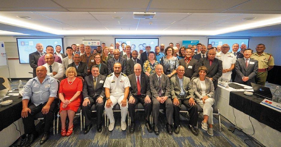
This was the first time delegates had gathered in person since 2020, bringing people from around the Pacific. The meeting was attended (in person and online) by 80 representatives from 15 nations, regional organisations and international intergovernmental organisations.
The meeting was preceded by an International Hydrographic Organization (IHO) funded capacity building two-day workshop on hydrographic governance, attended by 30 delegates from Pacific Island countries, hydrographic offices, the IHO, and subject matter experts.
The purpose of the workshop was to review a high-level hydrographic governance gap analysis that provides foundational data relating to the status of national interest, national arrangements and external coordination. The output was an action plan for each country to bridge the gaps.
NEW DEAN FOR SCHOOL OF SURVEYING Division of Sciences Communication, University of Otago
Antoni Moore, an Associate Professor in Geographical Information Science, is the new Dean of the School of
Surveying at the University of Otago. Antoni takes over the role from Professor Christina Hulbe, who held the position for ten years. Antoni says Christina displayed exemplary leadership during her time as Dean, including curriculum changes and positioning the School as a Te Tiriti-led place of learning and research.
Antoni says he’s keen to give back to the School which includes exploring convergences and synergies in the many different fields that surveying encompasses. He is also looking forward to engaging with Survey Spatial New Zealand and the profession as a whole in his new role.

His arrival also coincides with a change in the curriculum for students commencing their degrees in 2023, including two new first-year papers. “These changes reflect surveying in the 2020s, bringing together the many different fields that the School covers, from geospatial science – GIS and remote sensing – to land planning and development as well as surveying measurement. All these areas can be applied to societal challenges and opportunities, including the critical issues facing us today, such as climate change.”
Antoni transferred to the School in 2008 following seven years in the Department of Information Science. As well as his long-standing research interests in geographic visualisation and cartography, he is a lead principal investigator on a Royal Society Marsden funded project (Strand) that’s exploring climate change related flooding hazards and impacts on coastal property values. He is also currently the president of the New Zealand Cartographic Society.
NEW WEBSITE, NEW LOOK FOR SURVEY AND SPATIAL NZ MEMBERS

In March, a newly refreshed Survey and Spatial NZ website was launched.
Ashley Church, CE says “He was delighted to present the new site with a fresh, clean look to members. With the last major upgrade in 2017, it was very timely.
“Work on the refresh started in the latter part of 2022 when Cyberglue, our website and member database provider, introduced new functionality allowing much greater flexibility with the layout design and content management. The last major upgrade was a while ago so we’re delighted to finally deliver this new version to members.”
You’ll notice some changes and new features. There is a new member’s Dashboard layout and new member directory and profile layouts for both companies and members to use for marketing purposes. The simplified menu tabs make it easier to navigate around the site.
With making communication easier for everyone in mind, we have introduced another new feature – a members’ Tipline to keep in touch. The Tipline will not only be on every webpage but also in all our email templates.


