1. Literaturereview
1.1. Methodology
The literature review was conducted using: Scopus, Web of Science and Google Scholar as search engines. Initially, we collected original articles, book chapters, conference proceedings, extended abstracts written in English and published by international journals after peer review and also thesis and reportswritteninFrench.
Thepaperswerecollectedusingdifferentkeywordssuchas“Landsubsidence”,“Coastalvulnerability”, “Sea level rise”, “Accretion”, “Erosion”, and “Gulf of Guinea”, “Nigeria”, “Ghana”, “ Côte d'Ivoire”. Afterward, weidentifiedthepublicationswiththeselectedkeywordsforthepurposesoftheworkandadatabase of selected workswascreated.
1.2. Theliteraturedatabase
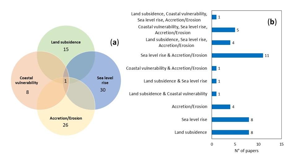
A total number of 44 papers were identified (the list is provided in Appendix). These documents were subdividedintogroupsbasedonthecontentofthepublicationsandusingfourresearchtopics:“Land subsidence”,“Coastal vulnerability”,“Sea levelrise”,“Accretion/Erosion”. Publications dealing withmore than one research topic were also noted and the number of papers overlapping different topics are shownintheVenndiagramandahistogram(Figure1).Theresultsshowthatonlyonedocumentcovers all the selected research topics, suggesting additional efforts should be devoted to the integration of different phenomena such as land subsidence, SLR and accretion/erosion in studies for the assessmentofthecoastalvulnerabilityoftheGulfofGuinea.The mentionedpaperwasdevelopedby Addo(2013)andevaluatedthecoastalvulnerabilityindextoclimatechangearoundAccra(Ghana).In this work, local subsidence trend and accretion/erosion rates are included as relative risk factors to assess the coastal vulnerability. SLR rates extracted from previous works were used to discuss the vulnerableareasoftheAccracoastbydistinguishingthreecategories suchaslow,mediumandhigh vulnerablestretchesof thecoast
7
Figure1.Venndiagramandhistogramoftheliteraturereview.
(a)Venndiagramoftheliteraturestudywiththetotalnumberofpapersgroupedusingfourkeywordsandtheirintersectionsofthe fourtopics. (b)Histogram of thenumberof papers that havebeentagged withone ormorethanonekeyword.
1.3. Databaseanalysis
Most of the papers (30) deal with SLR. Among these papers, eight do not connect to other topics. Fashae and Onafeso (2011) examined the historical trend in storm tide along the coast of Lagos, and projects the potential impact on coastline change considering scenario-based climate change predictions from three different general circulation models (GCMs). The change in erosion rates and stormsurgeprogressionwereevaluatedusing satellite imageriesfromLANDSATThematicMapperfor 1999 and 2009 Idowu and Home (2015) carried out empirical predictions considering the probable effectsofanthropogeniceffectssuchas theland reclamationactivitiescoupledwithprojected SLR in the stretches of Lagos coast. In this work, the data come from a literature review across various disciplines, predictions and reports from monitoring agencies, global organizations, and real-life experiences. The authors state thaton the global scale, various predictions on SLR indicate values of1 m by the end of the century, but the high uncertainty related to the existing models based on continentalicemeltingisachallengeforpredictingSLR. Furthermore,excessiveanduncontrolledland reclamation activities on the lagoon side of the city, will aggravate the situation Musa et al. (2015a, 2015band2016)consideredthe effects oftheSLR onflood duration,flooding reachandwaterdepth in the Niger river basin and along the lower Niger delta The authors used SRTM DEM from NASRDA data archives to assess the elevation of the Niger delta, but these satellite-derived DEMs have less vertical accuracy, higher bias and higher RMSE than other DEMs derived from airborne lidar and airborne as explained in section 3.2 of this report. The effect of different SLR scenarios was also studied by Onwuteaka(2014)toassess theflood exposure oftheNigeriancoastalareas.
Withoutspecificquantitativemeasurements,SLRwasconsideredtoassesssubmersionrisksataworld scaleandinWestAfricabyTessleretal.(2015)andAlvesetal.(2020),respectively. Inparticular,Tessler et al. (2015) introduced a systematic global-scale assessment of the changing risk profiles of coastal deltas, whereas Alves et al. (2020) carried out a review on coastal erosion and flooding risks, together with bestmanagementpracticesinWestAfrica
Eleven papers deal with SLR and accretion/erosion rates. Three papers (Addo et al., (2008); Addo and Adeyemi(2013)andEvadzietal.,(2017))includeSLRrate of2mm/yr inconformitywiththeglobal trend, with historic rate of erosion equal to 1.13 m/yr (±0.17 m/yr) in Accra, Ghana. The large range of SLR used forfuturescenariosrangingfrom2to6mm/yraffectstheuncertaintyoftheresults.Theauthorsfound that the western and the eastern regions areas of the Accra coast are eroding more rapidly than the central region (−0.2 m/yr) reaching values of 1.7 and −1.9 m/yr, respectively. This evidence should be due to the geomorphic and geological features and the engineering interventions (reclamation and constructionofgroynesandrevetments)thatcouldberesponsibleforstabilisationandaccretion.The authorsstatedthattheoverallboundsofthepossiblerecessionratesare−2.45m/yrand−1.27m/yr The predictions show that some important infrastructures will be lost in the future such as the Kwame Nkrumah Mausoleum in 2152, the Independence Square between 2082 and 2112, and Christianborg Castle in 2052. Addo et al. (2015) evaluated for the same area the interactions between SLR, hydrodynamic forces, seabed, beach morphology and potential sediment transport as well as anthropogenic activities. The report produced by the United Nations Environment Programme (UNEP) in 1985 described the control factors (i.e., the physical structure and the nature of the rocks) of the erosion and the regional historical trends of the SLR along the Coast in West and Central Africa However,currently,theanthropicpressureinthestudyareaisverydifferent.Inthework byGiardinoet al.(2018)theareallandlossesduetoerosionandcoastalretreatasaresultofman-madeinterventions andclimatechangewithrespecttoareferencescenariowerequantifiedandalarge-scalesediment budget was developed using a numerical model for the Gulf of Guinea. The authors found that the effects of the current major ports on coastal erosion will be of the same order of magnitude as the effect of lower SLR scenarios (RCP 4.5 climate scenario). Future local accretion or erosion of the shoreline up to 1–2 m/y, may be caused by climatic effects on offshore wave conditions (i.e., wave height and incoming wave direction) and in river catchments (e.g., precipitation or temperature). Overall, the study gave insight into the interdependency between different interventions along the rivers and at the coast on the sediment budget, suggesting that a large-scale integrated sediment managementplanisneeded forsedimentmanagement
8
Furthermore, Evadzi et al. (2018) evaluated the awareness of sea-level response to climate change in the coast of Ghana using semi-structured interviews at national, municipal/district and coastal community scales. The authors reported that most communities on the coast of Ghana are aware of SLRand thecoastalerosion impactontheircommunities,butthe causes of thisproblemwere mainly attributed to God indicating the need for educational outreach programs on SLR. Some communities stated that the sea defense wall in their area does not allow drains to flow easily from the mainland into the sea, resulting in favorable conditions for mosquitoes that increased malaria cases. Fishing communities expressed a negative opinion about the sea defense project because landing sites are not provided The authors stated that there is a need of facilitated discussion learning programs to improve cooperative relationships between national, district, and local authorities with coastal researchscientistsandengineers,andcommunities along thecoastofGhana.
Two papers provided measurements of the SLR in the Western African region using satellite altimetry data(Meletetal.,2016;Martietal.,2021)andmentionedthatthisdatawillbeimportanttofurtherassess if the coastal regression will be mainly due to natural or anthropogenic factors. Ozer et al. (2017) used high spatial resolution images available in open access on Google Earth to evaluate the coastal dynamics.Thestudyfoundthat34%ofthecoastalareaofTogoandBeninisstable,14%ischaracterized by accretion in upstream of harbor infrastructures, but a large part (52%) experiences erosive processes, sometimes exceeding annual average retreats of 10 m/yr. In addition, a recent study proposedbyDadaetal.(2021)mentionedthatSLRandchangesinthefrequencyandpowerofextreme meteorological events are increasing the impact on coastal flooding and erosion, thus acceleration of land loss in the Western African coast. A rise greater than the global average is expected for this area, but a gap in SLR data does not allow to generate future projections with high confidence. For example, few regional climate models or empirical downscaling were produced to create climate changescenariosfor this region(Dada etal.,2021).
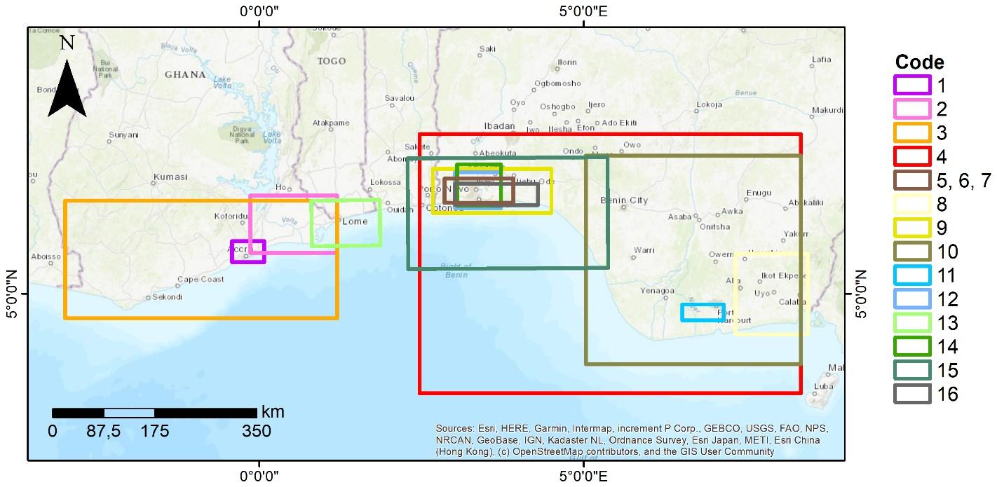
Regarding the topic of land subsidence, a detailed study was performed to extract relevant characteristics of the previous works. A summary of the land subsidence studies is listed in Table 1, includingthesubsidencevaluesandthedifferentdrivers.Thegeographiclocationofthestudiedareas isrepresentedinFigure2.Inparticular,theliteraturereviewshowsthatlandsubsidencehotspotswere detected in Lagos, Niger delta, Port Harcourt, Warri and Volta delta. No specific studies were found about land subsidence in Abidjan, Accra, Togo and Benin areas that were indicated as affected by subsidence by Cian et al. (2019) In Lagos, the authors recognized different drivers of the land sinking such as groundwater extraction, natural loading isostasy, peatland reclamation and loading by building(Ikuemonisanetal.,2021a,b).TwopapersreportedthatlandsubsidenceinLagosismainlydue to the over-abstraction of groundwater (Ikuemonisan and Ozebo, 2020, Mahmud et al., 2016a) Available groundwater data indicated a general decline in hydraulic head between 2011 and 2017, but studiesabouttheamountsofwithdrawngroundwaterareunavailable Landsubsidenceisalsodueto land reclamation as observed at the Lekki peninsula. Furthermore, Ikuemonisan and Ozebo (2020) suggest that the settling of Holocene sediments and isostatic deformation resulting from thepassive continentalmarginofanAfricanplatearepossiblefactors influencing thesubsidencerate.Thedirect negativeeffectsexperiencedinLagosaredamagetoinfrastructure,increasedoccurrenceofflooding, and increased coastal erosion (Ikuemonisan et al., 2020) Satellite-based estimates of ground settlement in some parts of the Lagos metropolis is very severe with reported rates up to -94 mm/yr (Ikuemonisanetal.,2021 a,b), however a recentsatellite-based analysis reported muchlower vertical landmovementsforthecity(Ohenhen&Shirzaeietal.,2022),revealingtheneedforgroundtruthdata to validate these spaceborne estimates In both analyses the settlement rate is unevenly distributed because of heterogeneous geotechnical soil properties and different groundwater extraction rates and land use. In the Nigerian delta, Port Harcourt and Warri are subsiding not only for natural drivers such as tectonic movements and compaction of recent sediments but also for the fluid withdrawal fromaquifersandhydrocarbonreservoirs(FabiyiandEnaruvbe2014;Ericsonetal.,2006;Ukoetal.,2018; Mahmudetal.,2016b).
Unfortunately, no comprehensive publication provides relevant information on the contribution of differentdriversoflandsubsidence.Thisknowledgeisrelevantfordistinguishingbetweennaturaland anthropogeniclandsubsidenceandenableprojectionsofitfollowingdifferentdriversandprocesses,
9
ofwhichsomearemoreorlesslinearwhileothercanbehighnon-linearintimeandspace(e.g.Shirzaei etal.,2021).Increasingthisunderstandingiscrucialtoenableinclusionof landsubsidenceintoreliable projections ofrSLR and tothinkof better suitedadaptationplans.
10
Figure2.Landsubsidencestudiespreviouslyperformedinthestudyarea.
Thelocations of thestudy sitesreported inTable 1 arerepresented by polygons.
Code
1 Addo(2013) Accra,Ghana Tide gauge Takoraditide gaugestation
2 Addoetal.(2018) Voltadelta, Ghana Notmeasured
3 Boatenget al.(2016) Ghana Tide gauge Takoradiand Tematide gaugestations
-1to-2 (hypothesis)
4 FabiyiandEnaruvbe (2014) Nigeria Space-based ASTER(2001)and SRTM(2008) 2001-2008 from-20to-50 -100
Hydrocarbon extraction
5 Ikuemonisanand Ozebo(2020) Lagos,Nigeria GPSandSBASInSAR
7 Ikuemonisanetal. (2021)a, b Lagos,Nigeria
8 Udoh&Udofia(2014) AkwaIbomState, Nigeria
9 Mahmudet al.(2016)a Lagos,Nigeria StaMPS ENVISAT
from-4 to-7
Groundwater extraction
loading Isostasy
Groundwater extraction Peatlandreclamation Loadingby building
Groundwater extraction
11
Table1.Summariesofthecasehistoriescharacteristicsofthepreviouslyreportedlandsubsidencestudies.
Studyarea Method Data Monitoredperiod Rangeof subsidence*rates (mm/year) Max.subsidence rates(mm/year) Drivers
Authors
- ≥ -1and≤ 1 - -
from
- -
-
- ≤ -1 - -
GPS** ENVISAT Sentinel-1 2011-2014 2004-2011 2015-2019 -3.3 -15 from-4.9
to-64
2015-2019 -8.7 -94
Natural
6,
SBAS-InSAR Sentinel-1
- - -
- -
Groundwater extraction
2003-2010
-
12 Peatlandreclamation Loadingby building
Ericsonetal.(2006) Niger delta,Nigeria - - - -Hydrocarbon extraction
Ukoetal.(2018) Niger delta,Nigeria Levelingdata - 1988-2003 from-66.67to200 - -
Cian
Lagos,Nigeria SNAPand StaMPS ENVISAT Sentinel-1 TerraSAR-X 2004-2010 2015-2018 2009-2013 from-2to-5 - -
Guerrera
(2021) easternGhanaand westernBeningulf - - - -Tectonicmovements Groundwater extraction
Wu
Lagos,Nigeria SNAPand StaMPS Sentinel-1 2015-2020 ≤ -2 - -
Ibe&Quelennec (1989) GulfofGuinea - - - - -25 Tectonicmovements
Tayet al.2022 Lagos,Nigeria InSARARIA-SG Sentinel-1 2014-2020 From5to-13 -13 -
10
11
12
etal.(2019)
13
etal.
14
et al.(2022)
15
16
2. Elevationassessment
2.1. Studyarea
ThecoastofGulfofGuineacomprisesseveralgeologicformationsofdifferenteras.Theserangefrom theearliestArcheantotheQuaternaryperiod.Thegeologyofthevariouspartsofthecoastdetermines the “resistance” to erosion and land subsidence. Soft geological formations such as the unconsolidated Quaternary materials are less resistant than stronger geological formations like plutonicandmetamorphicrocks (Heckmannetal. 2022).
Inthestudyarea,thebeachevolutioniscontrolledbynaturalandanthropogenicfactors,whichcause shoreline recession (erosion) and/or accretion, depending on prevailing exogenic and endogenic processes (UEMOA, 2017) The main anthropogenic factors that control beach evolution in the Gulf of Guinea include coastal development, the construction of nearshore infrastructure as a result of demographic pressure, as well as the construction of seawalls and other coastal structures, and humanactivitiesthatleadtochangesinsedimentsupply,suchassandmining,hydropowerandriver dams, dredging and land-use changes (Almar et al., 2015). Wind, waves and marine currents are natural forces that easily move the unconsolidated sediments along the beach, causing rapid modifications. The short-term beach evolution is determined by small-scale processes such as storms,waveaction,tidesandwindcontrol,whereasthelong-termevolutiondependsonlarge-scale processessuchasclimatechangesandtectonicactivity.Thelattercausesverticalmovementswhich may be increased by anthropogenic land subsidence due to groundwater withdrawal, building load, etc.(e.g. Shirzaeietal.,2021) contributingtorSLR.
2.2. Advantagesanddisadvantagesofsatellite-deriveddigitalelevationmodels
Digital Elevation Models (DEMs) are crucial inputs for SLR exposure and riskassessments. Asglobal SLR projected for the 21st century are in the order of several decimeters, ranging from 30 cm to 80 cm or more by 2100 (IPCC, 2021), ideally the DEM should provide a similar vertical accuracy as is the case for DEMs created using high-accuracy elevation observations likeairborne-based laser altimetry (LiDAR) or ground measurements from geodetic surveys. However, such data are not often available at a regional scale, or when they exist are not publicly available for the scientific community, especially in countriesoftheGlobalSouth.Asaresult,globalorregionalassessmentofSLRexposureusuallyrelyon DEMs derived from radar satellite altimetry data such as the NASA’s SRTM DEM (Farr et al., 2007) and morerecentlyonLiDARsatellitedata(Vernimmenetal.,2020).However,satelliteradardatamayhave largebiases,uptoseveralmetersinsomeareas.Errorsmayarisefromthepresenceofcanopycover, buildings or artefacts (Minderhoud et al., 2019; Almar et al., 2021; Hooijer and Vernimmen, 2021), which may lead to an over- or underestimation of exposure to SLR. On the other hand, LiDAR can penetrate vegetation canopy to create more reliable DEM in region with dense vegetation data. A new DEM interpolated from LiDAR (ICESAT-2) satellite data (that provides incomplete spatial coverage) have recently lead to an upward reassessment of coastal population exposed to SLR (Hooijer and Vernimmen,2021),howeverthehorizontalaccuracyisonly~5km,i.e.muchlowerthanthe90mor30m spatial resolution of the SRTM for instance. High-resolution on demand missions now also offer a promising at regional scale and hotspots (500 km²) to assess fine scale morphological features such asprotectionsanddunes(Almeidaetal.2019;Salamehetal.2019;Taveneauetal.2021) Asnewsatellite increasingly accurate data will become available in the coming years, updated assessments with higher accuracy are expected, and represent a real game changer in West Africa (Almar et al. 2022) In addition, to the above-mentioned issues, global satellite-derived DEM are usually referenced to a geoid,whichrequires thecorrection of thevertical datum tolocal sealevel,an step oftenforgottenin SLR impacts assessments (as highlighted by Minderhoud et al., 2019). This omission can lead to
13
additional vertical biases in coastal elevation assessment as the global geoid models can deviate fromlocalSLRup toseveralmetersinextreme cases.
2.3. Datasets
2.3.1. CharacteristicsoftheDEMsconsideredinthisstudy
A wide variety of space-borne digital elevation models (DEM) based on Radar and/or LiDAR data became publicly available recently. The combination and comparison of multiple elevation models help to arrive at a superior assessment of local elevation. In the study, we compare and assess the potential offered by open-access and recently released DEMs, for an up-to-date coastal evaluation for the Gulf of Guinea region. These include: CoastalDEM version1.1, CoastalDEM version 2.1, SRTM-ACE2, ALOS DEM (AW3D30), and FABDEM. The characteristics of the different DEMs are presented in the overview of Table 2. We have highlighted the specifications of the different DEMs considered advantageousfor thestudyingreen.
SRTM ALOS-PRISM COPDEM30 (itself based onTanDEM) Calibrationdata
airborne lidar-
LiDAR DTM, ICESat-2 Kulp & Strauss (2021) Berry et al. (2010) Jaxa(2021) Hawker et al. (2022)
Overview ofkeycharacteristics ofthesatellite-based DEMs consideredinthis study. Key specifications havebeenindicated based onacolourschemeforfeaturesconsidered advantageous (green)or limiting(orange)forourstudypurpose
14
Table2.KeycharacteristicsoftheDEMs.
CoastalDEMv1.1
CoastalDEM v2.1 SRTM-ACE2 ALOS-DEM (AW3D30) FABDEM
derived elevation data in
Basedata(radar) SRTM NASADEM (modernized versionofSRTM) Australia
the U.S. and
NASA’s ICESat-2 LiDARGlobally ERS1,ERS2, Topex,EnviSat and Jason-1
ICESat-2, crosscalibration: SRTM, ASTER GDEM, PRISM (airborne) Elevationalrange ofcorrections 1-20m -10m-120m - -Treeheightbias removed V V x X V Buildingremoval x x x X V Ellipsoid WGS84 WGS84 WGS84 WGS84 WGS84 Geoid EGM96 EGM96 EGM96 EGM96 EGM2008 Spatialresolution (m) 30 30 90 30 30 Model architecture perceptron neuralnetwork convolutional neuralnetwork Datafusion VoidFilling Random forest Released 2019 2021 2010 2021(Ver.3.2) 2022 Reference Kulp&Strauss (2019)
In terms of calibration data, the use of global data is important to ensure representativeness. For instance, initial calibration of CoastalDEM v1.1 on data from the US, and validation in Australia resulted inanoverfitandlimitedtransferabilitytoothercoastalregionsglobally(Kulp&Strauss,2019).Moreover, the ingestion of LiDAR (spaceborne: ICESAT-2) and precise airborne measurements are considered superior for calibration. In general, LiDAR systems are considered to offer higher precision for the estimationofcoastalelevationascomparedtothemorewidelyavailableradarinstrumentsduetoits generally higher vertical resolution, direct measurement techniques, and being less affected by surface roughness and vegetation cover compared to Radar systems (Vernimmen et al., 2020). However,satellite-basedLiDARmissionstillofferlimiteddataavailability,asfewsatellitesareequipped with LiDAR sensors and tend to have smaller swath lengths, moreover its performance is weather dependent,anddataprocessingandstorageiscomputationalmoreintensivecomparedtosatellitebased Radar inferences (Salameh et al., 2019). The tree height bias removal is relevant as densely vegetatedareascanresultinDEMsthatoverestimatetheelevationheightduetothescatteringeffects of vegetation. For instance, the presence of dense mangrove forests can inflate the height of the shoreline.Inadditiontotreeheightbiasremoval,therecentFABDEMalsocorrectsforbuildings(Hawker et al. 2022). The spatial resolution is preferable high to add detail to the spatial variation in coastal elevation. MostoftheDEMsstudied hereareavailableata30mspatialresolution
2.3.2. DEMcorrection
AllfiveDEMs havebeenverticallyreferencedtolocalmeansealeveloftheGulfof Guineaas opposed to the standard global vertical reference datums. Local mean sea level data have been derived from AVISO’s Mean Dynamic Topography (MDT) datasets describing the mean sea surface height above geoid computed on a 20 years period (1993-2017). The MDT dataset was produced by CLS and distributedbyAviso+,withsupportfromCNES(https://www.aviso.altimetry.fr/).TheMDTdataintegrates ocean mean geostrophic currents as meansea levelheightsdiffer across theglobal. The MDTcovers the seas and oceans globally. To correct the DEMs also at inland positions, the mean local sea level points along the coast were interpolated for the inland region using Inverse distance weighted (IDW) interpolation,similar totheapproachbyVernimmenetal. (2020).
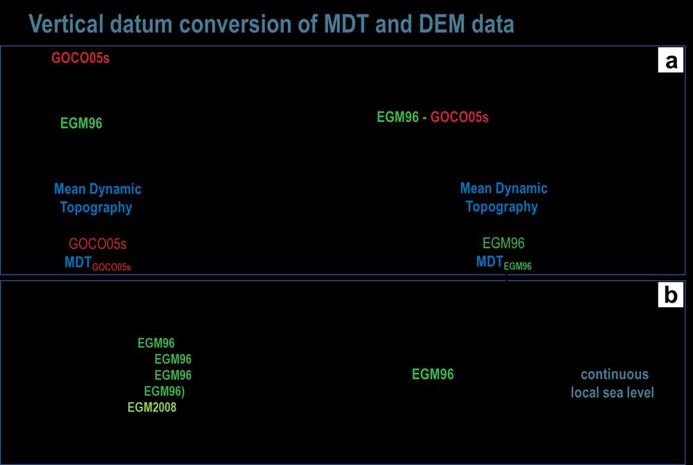
Workflow to convert all DEM and MDT data to the EGM96 geoid model (vertical datum) (a) and correction of global DEMs to local meancontinuoussealevel (b)(modifiedfromSeegeret al.,2023).
15
Figure3.WorkflowforDEMcorrection.
The initial global DEMs were referenced to different geoid models (vertical datum). Four DEMs were projected to the EGM96 model, whereas FABDEM was referenced to the EGM2008 geoid, and the MDT data to the the GOCO05s vertical datum. To convert the DEMs to local mean sea level in the Gulf of Guinea as well as the cross-comparison of the different DEMs, a harmonization of the vertical datum wasneeded.Assuch,alldatawasconvertedtobeconsistentlyprojectedverticallytotheEGM96geoid model. The diagram in Figure 3 overviews the workflow to correct DEMs to local mean sea level (b) as wellasthepriorconversionofalldatasetstotheEGM96geoidmodel(a).Forthecalculationofgravity field functionals on ellipsoidal grids, we made use of the ICGEM conversion computation (available through: http://icgem.gfz-potsdam.de/calcgrid). This allows comparison of different vertical datum (geoids) against the WGS84 projection (ellipsoid) to enable conversions. Point data has been interpolated using multiquadric radial basis functions as the use of multiquadric RBF has been established to be the most suitable for geoid data interpolation in Doganalp and Selvi (2015) and a number ofstudies reviewed byForoughietal. (2018).
2.4. Methodology
2.4.1. ShorelineprofileforDEMcomparison
For visual comparison of the different corrected DEMs we made use of shoreline profiles, running perpendiculartothecoastline,aspresentedinDiazetal.(2019)andAlmaretal.(2021).Shorelineprofiles offer a valuable tool for visual comparison of the different DEMs in a harmonized way that is easy to comprehend visually and targeted to low-lying coastal regions in our study area. By comparing the profiles, we can observe how the DEMs differ from each other in terms of relative skewness or discrepancies. In other words, the method provides a quick and easy way to visually and comprehensiblyevaluatethe (dis)agreementofdifferentDEMsinlow-lying coastal regions.
16
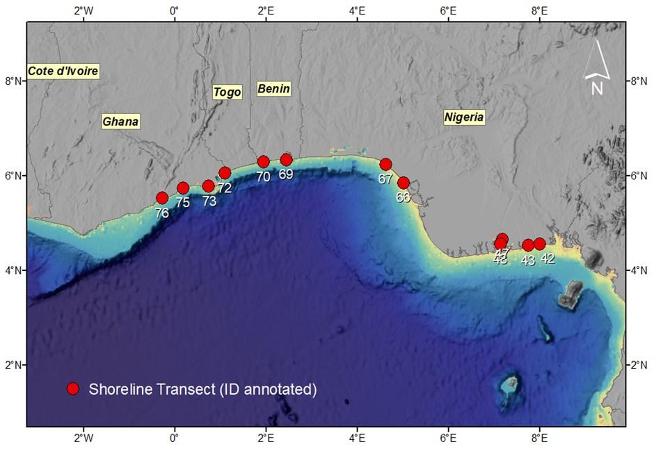
Figure4.Locationoftheshorelinetransects.
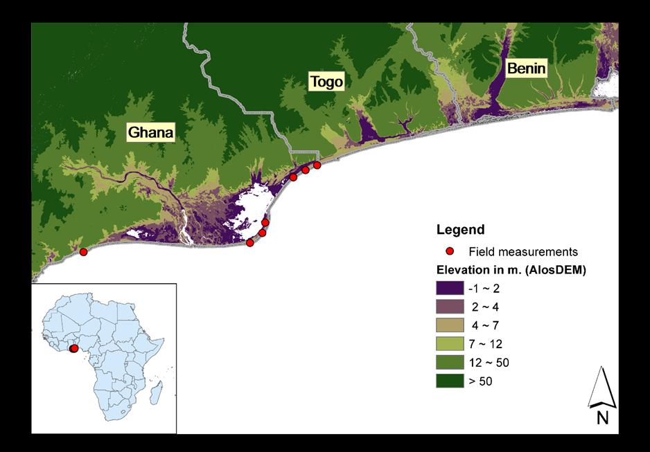
Overview oftheshorelinetransects (12a piece; 6pairs)sampled acrosslowlyelevatedcoasts of Ghana,Togo,Beninand Nigeria. Baselayercomprises ofthecombined bathymetric/topographic digitalelevationmodels stewarded at NOAA's National Centers forEnvironmentalInformation(NCEI),availablethrough: ArcGISOnline (https://gis.ngdc.noaa.gov/arcgis/rest/services/DEM_mosaics/DEM_global_mosaic_hillshade/ImageServer)
The Global Self-consistent, Hierarchical, High-resolution Geography Database (GSHHG) coastline, whichcontainsthelatitude/longitudecoordinatesofthecoastline,wasusedtodrawsamplelocations (Wessel&Smith,1996). Thedatabase consists of14,140transects alongtheopencoasts of theworld of which 106 are located in our study area. Twelve transects with the lowest average coastal elevation according to the GSHHG and located in Ghana, Togo, Benin and Nigeria were selected (Fig.4). The 12 elevation profiles were then extracted from the DEM using the coordinates from the GSHHG. The coastal shoreline and topography are highly variable alongshore. Therefore,in order to obtain reasonably robust estimates, regional profiles are constructed by averaging two neighbouring elevation transects. All transects lead up to 2 km of sample points inland, with 20 m intervals, totaling 100pointswhichareplotted using3pointsmovingaveragesoensuresmoothprofiles(Fig.8).
2.4.2. Insituvalidation
Ground truth validation is extremely valuable to assess the bias and uncertainty involved in satellitederived coastal height estimates. In-situ validation has been conducted based on a small dataset of groundcontrolpoint(GCP)heightmeasurementsintheVoltaDelta,Ghana.Intotalthemeasurements consist of seven GCP data measured in June 2009 and April 20211. We have takenthe average of both time moments to increase the robustness of the measurements and provide versatility to the temporal variation and composite nature of the different satellite-based DEMs. The in-situ measurements have been recorded on EGM2008 vertical data, and hence transformed to EGM96 for this study’s purpose. Commonly used accuracy metrics are applied to understand the error and devianceoftheDEMsagainstthein-situmeasurements.Theseincluderootmeansquareerror(RMSE), Meanabsoluteerror(MAE),andtherank-basedcorrelation(Kendall’stau)betweenin-situandspaceborne elevationmeasures.AnoverviewforthelocationoftheGCPforin-situmeasurementofcoastal elevation can be found in Figure 5. One of the GCP (located in Great Ningo, westernmost point) has been measured verycloseto the shoreline. The GreatNingo GCP’s vincinityto thecoastline produced missingvaluesacrossallfive satellitedatasetsandthereforewasomittedfromof theanalysis.
17
Figure5.Overviewofthein-situgroundcontrolpointsforvalidationofelevationestimates.
Datapoints arelocatedalong thecoast ofGhana’sVoltaDelta region.
1 Note: thereis virtually nodifferencebetween thevaluesmeasured in 2009and2021.
2.4.3. Coastalvulnerabilityanalysis
After validation and shoreline profile analysis, we focused on the most promising DEMs to scope potential coastal vulnerability hotspots. The key variables to determine potential vulnerability include the DEM-derived coastal elevation itself in combination with land use types. Cropland and built-up land cover types are considered as focal points given that these host the largest number of inhabitantsandland-basedeconomicactivity,andthuspotentiallythehighestvulnerabilitytohuman damage and loss. In addition, these land cover types are generally characterized by the highest anthropogenic land subsidence rates, thus posing a greater future risk to relative sea level rise (e.g. Abidin et al. (2011); Minderhoud et al., (2017)). The land cover type map is based on the Copernicus WorldCover dataset which provides a baseline global land cover product at 10 m resolution for 2020 based on Sentinel-1and 2 satellite data (Zanaga et al.,2021). WorldCover offers ten landcover classes and a minimum overall accuracy of 75%.Hence, vulnerability hotspots are defined by a coastal elevation height of less than 2 m above local sea level and characterized by cropland and built-up landcoverzones.
2.5. Results
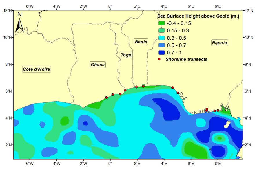
2.5.1. MDTlocalsea-levelmap
An overview of the local sea height deviation above the EGM96 geoid can be found in Figure 6. Most relevantare thevaluesclose totheshorelineas thesedeterminetheactualcoastal sea level and are subsequentlyusedtofillinvaluesinlandfollowinginterpolation.Figure7showsthedistribution(N=1200) of sea surface height above geoid for the selected shoreline transects (Fig. 4). Directly along the shoreline,deviationsof0.1mto0.7mfromtheglobalgeoidmodelarenotuncommonwithinourstudy area. Such deviations can stem from ocean circulation, temperature and salinity, tides, wind, waves amongstotherfactors.Together,Figure6highlightstheimportanceofconvertingthereferenceofthe data from the global geoid to the local sea level. Neglecting to do so can lead to large biases in the assessmentofcoastalelevationtolocalsealevelandthusrSLRimpactassessments.Thisisespecially important for the low-lying coastal regions we focus on as the observed differences in sea surface height(uptomultipledecimetres)canbeseveralmagnitudes larger thanglobalSLR
18
Figure6.SeaSurfaceHeightabovegeoid(EGM96)basedonAVISO’sMeanDynamicTopographyMDT-CNESCLS18isanestimateofthemeanoverthe1993-2017period.
Datasource: AVISO’s MeanDynamic Topography MDT-CNES-CLS18,whichis anestimate ofthemeansea surface height abovethe geoid over1993-2017.
2.5.2. Coastalelevationassessmentalongshorelineprofiles
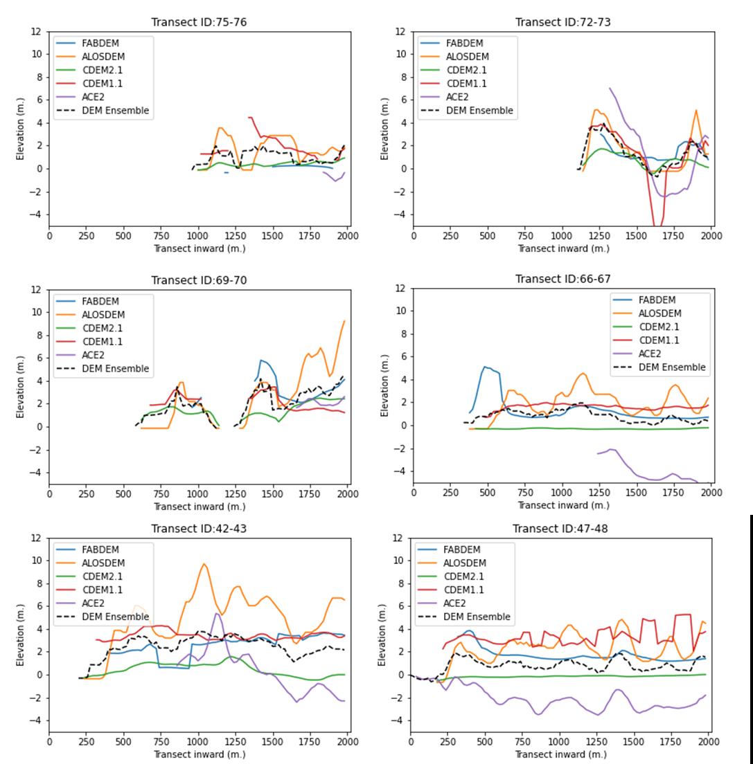
Shorelineelevationprofiles(2000mtransects)ofsixpairedlow-lyingcoastalareasalongtheGulfofGuineaasobservedbythefive differentDEMs(FABDEM, AlosDEM(AW3D30), CoastalDEMv2.1, CoastalDEMv1.1,SRTM-ACE2)andcomputed asensembleaverage. The locationof paired shorelinetransectscanbefound inFig. 4.
The coastal elevation profiles of six paired shorelines are presented in Figure 7. The data acquisition starts further or closer to the shoreline depending on the DEM. Interrupted lines generally indicate the shoreline transact crosses inland water surface (e.g.: lagoons, estuaries). The coastal elevation in inundated and sea-covered areas was unable to be mapped in the DEMs, however, differences exist across the different data sources in the starting point of detectable shoreline. In general, we find that ACE-2 tends toreportvalues muchfurtherinlandalong the transectsasopposed totheother DEMs.
19
Figure7.Shorelineelevationprofiles.
In general, we observe relatively large differences between DEMs over the same transects. These differencesareintherange ofmeters(magnitudeofthedeviationbetween1.1and 3.4m,Table 3).The shoreline profiles illustrated by ACE-2 in these low lying transects deviate the strongest from others andtheensemblemedianvalue(RMSE:3.43,Table3).Thebiasofestimationtendstonegative(-2.7m) for ACE-2 which could have to do with the initial coarser resolution (90 m). CoastalDEM_v2.1 tends to give structurally lower estimations of coastal elevation as well yet to a lesser extent. AlosDEM, on the other hand, tends to give higher estimates of coastalelevation compared to theother DEMs. The lack of tree height bias removal could be underlying this overestimation. FABDEM, and to lesser extent CoastalDEM_v2.1, seems to fall most frequently in the middle of the pack, leading to the lowest error anddeviationofthemeanof allelevationmodels
Table 3: Descriptive and error metrics (Bias, Mean Absolute Error (MAE), Root Mean Square Error (RMSE) and rank-based correlation (Kendall’s tau) calculated between the five individual DEMs and the median ensemble of all DEMs across the six low-lying coastal transects. NaNoccurrences are omittedfrom analyses.
2.5.3. Insituperformanceassessment
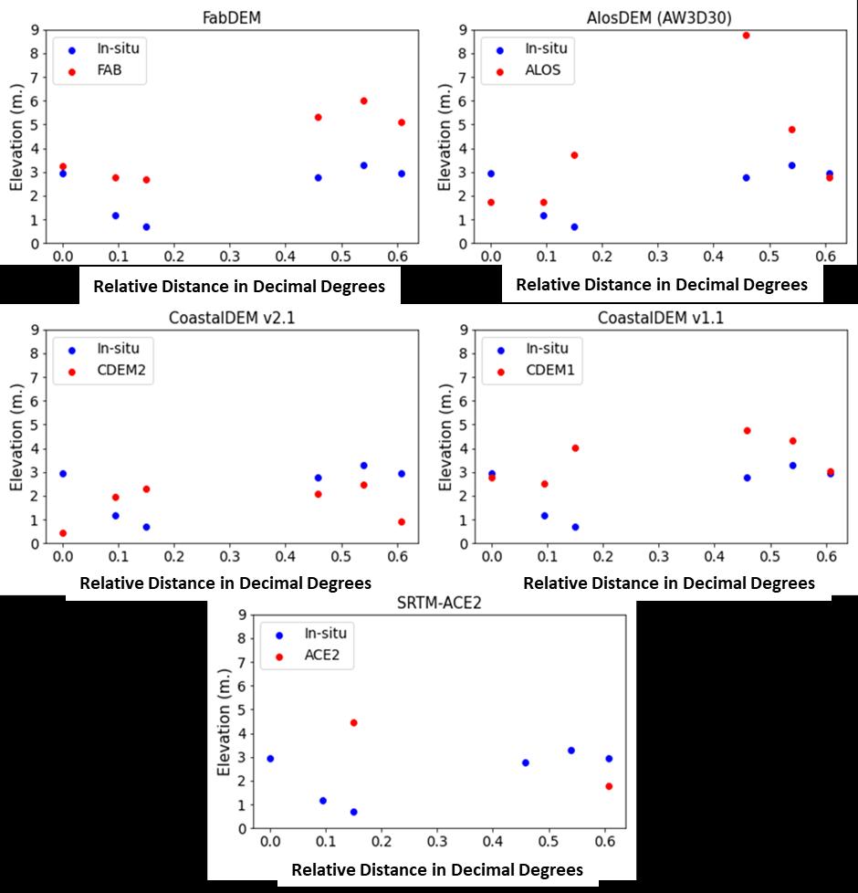
With six ground control points (GCP) in the Volta Delta, the in-situ validation is very limited in sample size.Yet,themeasurementsareconductedthoroughlyovertwomomentsintime(2009and2021)and averaged to create temporally more robust height estimates. Table 4 provides the key statistics to validate DEM performance against the ground data. The ACE-2 DEM is found to be problematic given that only two data points could be observed due to the earlier-mentioned data paucity at the coast. Moreover, there two points exhibit the strongest deviation from in-situ measurements compared to theother DEMs.AlosDEMhas thesecondlargesterror size according totheusedmetrics,howeverthis canlargelybeattributedtoasinglepointstronglyinflatingoverallMAEandRMSE,highlightingtheneed formorevalidationdatatoavoidlargeimpactofasingledatapoint.WeobservethattheCoastalDEMs perform very well in terms of error, with the latest version recording a slightly better accuracy (Table 4).IntermsofrelativedifferencesalongtheVoltaRegion,FABDEMrecordsarelativelystrongcorrelation which highlights its accuracy in capturing relative changes in coastal height. Figure 8 is illustrative of howthedifferentDEMsfollowthecoastalheightcurvaturealongthesixcoastalGCPsintheVoltaDelta. Basedoncross-validationagainstotherDEMs(previousparagraph)andthevalidationagainstin-situ GCPs, FABDEM and CoastalDEMs tend to be the safest to the other DEMs in terms of error size of this preliminary analysis. When considering the ability to capture relative height differences, FABDEM appearstobe themostconsistentoption.
20
FABDEM AlosDEM (AW3D30) CoastalDEM v2.1 CoastalDEM v1.1 SRTM-ACE2 Mean 2.22 3.15 0.63 2.78 -0.84 Median 1.87 3.00 0.46 2.79 -1.40 Std. Deviation 1.44 2.66 0.82 1.57 2.25 versus median ensemble Bias 0.20 1.34 -1.20 0.81 -2.74 MAE 0.70 1.58 1.29 1.14 2.98 RMSE 1.13 2.36 1.66 1.68 3.43
Table3.ComparisonoftheDEMperformancesalongtheshorelineprofiles
21
Fig.8:Scatterplotsdepictingin-situmeasurementsversusDEMestimatesofcoastalelevationalongsix geodeticcontrolpoints(GCP)intheVoltaDelta
The x-axis shows the distance between GCPs, in relative decimal degrees, where 0° refers to the most westward GCP See fig.5fortheGCP locations.
Performance assessments of the satellite-based DEM estimates against in-situ validation points (N=6) in the Volta Delta. The error metricsinclude MeanAbsoluteError(MAE),RootMeanSquareError(RMSE)and rank-basedcorrelation(Kendall’stau)).Kendall’stau could not becalculatedforSRTM-ACE2duetomissing data.*= significantat alpha<0.05level. ns= not significant.
2.5.4. PotentialrSLRvulnerabilityhotspots
The FABDEM and CoastalDEM v2.1 perform best in our analyses and assumably represent the actual coastal land surface level (LSL) best. Hence, we decided to use both DEMs in the coastal vulnerability to rSLR hotspot analysis to delineate areas below 2-m LSL to reduce the dependency on a single DEM andpotentialerrors herein. Mapsareprovided hereafter (Figures9to18) Theanalysis wascarriedout attwolevelsofcertaintyfollowingtwoapproaches.Thefirst,moreprecautionaryapproach,considers all areas identified below 2-m LSL in either of the two DEMs, while the second, higher certainty crossvalidated approach, considers the areas identified below 2-m LSL by both DEMs. To add a first spatial assessment of coastal risk, we linked coastal land below 2-m LSL to high risk land-use types. We considerBuilt-upAreasandCroplandasland-usetypeswithahigherrisktohumanlossanddamage. Thisisgiventhegenerallyhigherprobabilityoflandsubsidenceinthoseareasduetocompactionfrom heavy constructions and groundwater extraction for consumption and irrigation, both well-known causes for land subsidence and thus increased chance for rSLR (Shirzaei et al.,2021). In addition, builtup areas and cropland are tied to strong human presence and thus higher vulnerability through the effects of rSLR. Given the long stretch of coastline along the Gulf of Guinea, the results are presented for differentnational subsets.
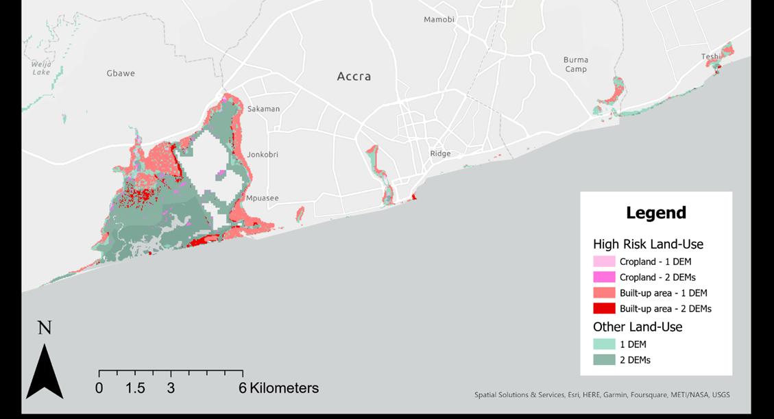
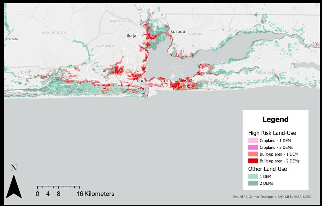
Nigeria,inparticular,contains largeareas below2-mLSL,mostofwhicharelocated inareas withlittle built-upandcropland landuse types. Weobserve,however,thatlarge parts of the megacityof Lagos are below 2-m LSL as identified by both FABDEM and CoastalDEMv2.1. Therefore, large potential vulnerability is at stake given rSLR. The concerns can be extended across the border from Lagos into Benin,regardingtheurbanresidentialareasofcapitalCotonou.OthercitieswithinNigeriasuchasthe greater Lagos area, Bonny, Warri, Port Harcourt (the latter two sheltered within the delta) are facing similarvulnerability.CapitalmetropolitanareasofAccraandAbidjanalsohavedistinctquartersofthe city below 2-m LSL with consequential vulnerability to rSLR, especially West of Accra and surrounding the Ebrie lagoonwithinAbidjan.
Theanalysisfocusedonurbanlandandcroplandasheavilyrelieduponareasforresidenceandfood production while also subject to vulnerability risk in terms of anthropogenic land subsidence. Beyond these lands, natural and extensively used low-lying areas are potentially also vulnerable to acceleratedrSLR.Anthropogeniclandsubsidencefollowing oilextraction,forinstance alongtheNiger Delta and surrounding coastal areas is likely, based on findings in oil extraction regions elsewhere (Zhang etal.,2015; Abija etal.,2020).Relative SLR in these natural regions canthreatenbiodiversity and relevant ecosystem services on which human and ecological communities rely (Furlan et al., 2022; Tregarot,2021).
22
FABDEM AlosDEM (AW3D30) CoastalDEM v2.1 CoastalDEM v1.1 SRTM-ACE2 MAE 1.89 2.08 1.41 1.32 2.45 RMSE 2.05 2.86 1.57 1.72 2.76 Kendall'stau 0.73* 0.14ns -0.07ns 0.20ns -
Table3.ComparisonoftheDEMperformancesatgroundcontrolpoints.
2.5.4.1. Côted’Ivoire

23
Figure9. Lowly-elevatedcoastalareas(elevation<2mabovelocalmeansea-level)inCôted’Ivoire.
Location of lowly-elevated coastal areas (elevation < 2 m above local mean sea-level), classified according to land-use types, in Côted’IvoireaccordingtotheDEMsFABDEMand CoastalDEM v2.1.Land-usetypesaretakenfromZanagaet al.(2021)
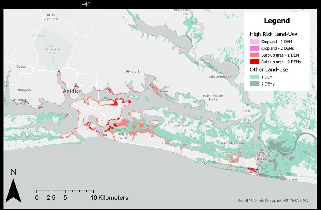
Figure10. Lowly-elevatedcoastalareas(elevation<2mabovelocalmeansea-level)inAbidjan.
Location of lowly-elevated coastal areas (elevation < 2 m above local mean sea-level), classified according to land-use types, in Abidjanaccording totheDEMs FABDEMand CoastalDEM v2.1.Land-usetypes aretakenfromZanaga etal.(2021)
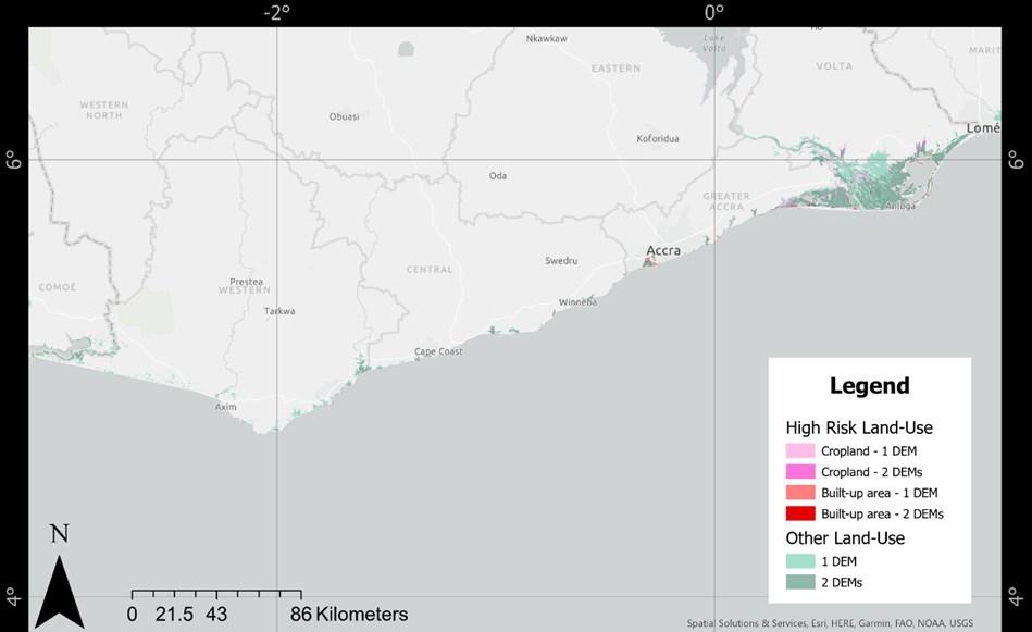
2.5.4.2. Ghana
Location of lowly-elevated coastal areas (elevation < 2 m above local mean sea-level), classified according to land-use types, in Ghana according totheDEMs FABDEMand CoastalDEM v2.1.Land-usetypes aretakenfromZanaga etal.(2021)
Location of lowly-elevated coastal areas (elevation < 2 m above local mean sea-level), classified according to land-use types, in Accra accordingtotheDEMs FABDEMand CoastalDEM v2.1.Land-use typesaretakenfromZanaga et al. (2021)
24
Figure11. Lowly-elevatedcoastalareas(elevation<2mabovelocalmeansea-level)inGhana.
Figure12. Lowly-elevatedcoastalareas(elevation<2mabovelocalmeansea-level)inAccra.
Location of lowly-elevated coastal areas (elevation < 2 m above local mean sea-level), classified according to land-use types, in theVoltadeltaaccordingtotheDEMs FABDEMand CoastalDEM v2.1. Land-usetypes aretakenfrom Zanaga etal. (2021)
2mabovelocalmeansea-level)in
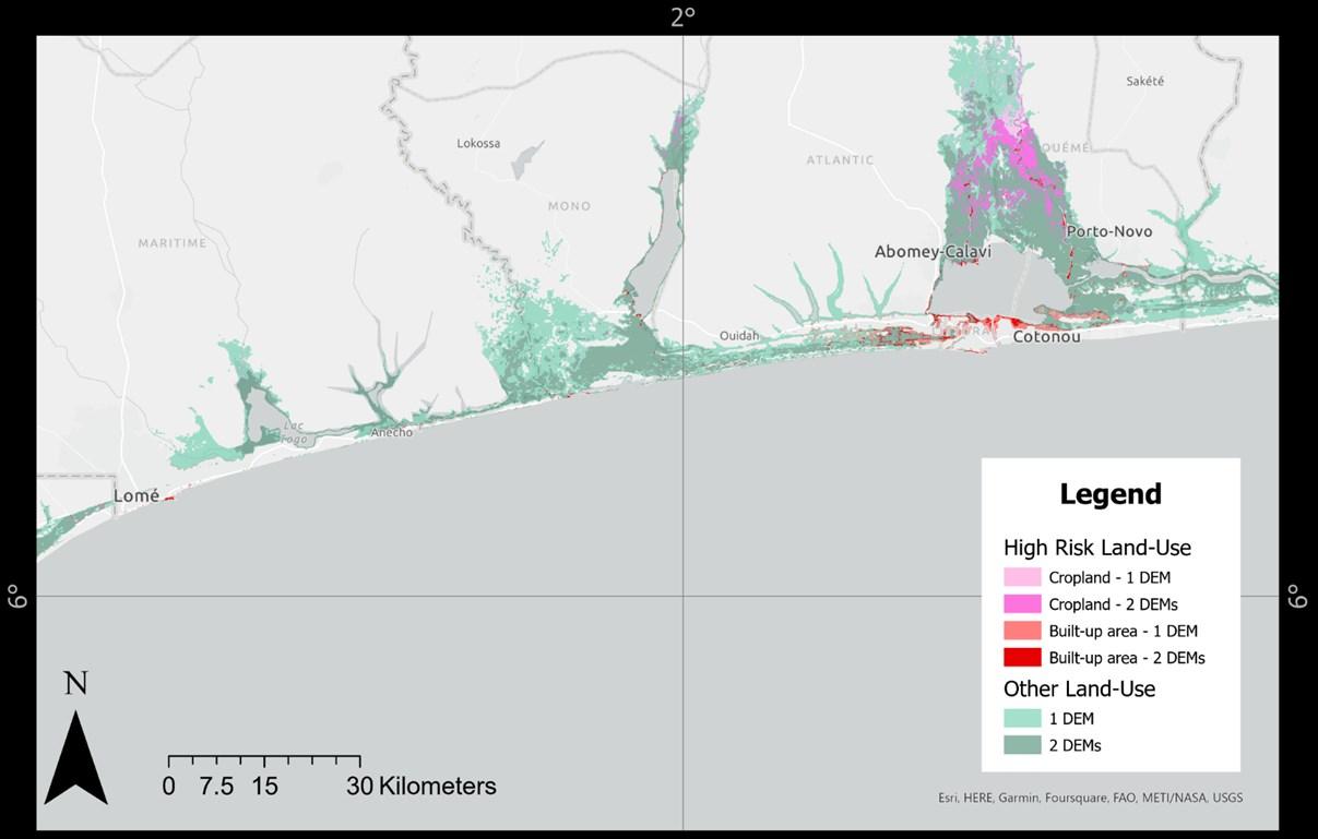
Location of lowly-elevated coastal areas (elevation < 2 m above local mean sea-level), classified according to land-use types, in Togoand Benin accordingtotheDEMs FABDEMand CoastalDEM v2.1.Land-usetypes aretakenfrom Zanaga etal. (2021)
25
Figure13. Lowly-elevatedcoastalareas(elevation<2mabovelocalmeansea-level)intheVoltaDelta.
2.5.4.3. TogoandBenin
Figure14. Lowly-elevatedcoastalareas(elevation<
TogoandBenin
2.5.4.4.Nigeria
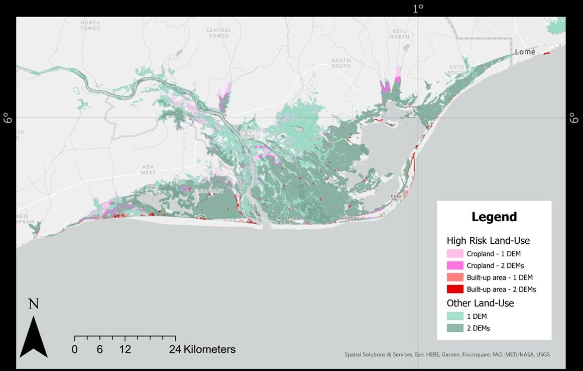
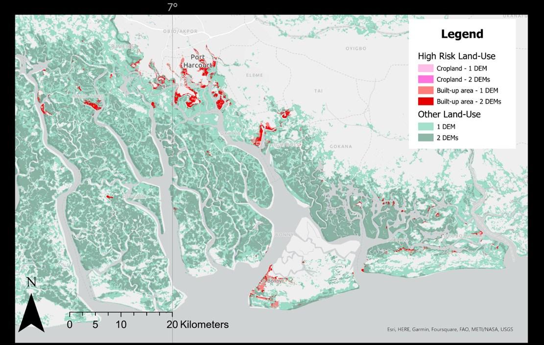
Figure15. Lowly-elevatedcoastalareas(elevation<2mabovelocalmeansea-level)inNigeria.
Location of lowly-elevated coastal areas (elevation < 2 m above local mean sea-level), classified according to land-use types, in NigeriaaccordingtotheDEMs FABDEMand CoastalDEM v2.1.Land-usetypes aretakenfromZanaga etal.(2021)
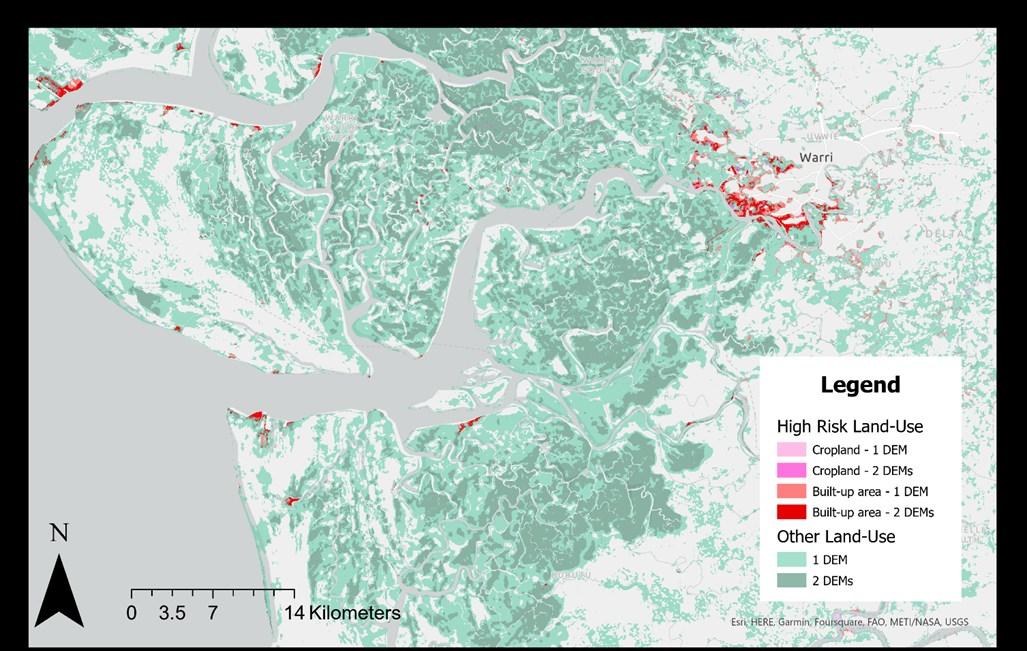
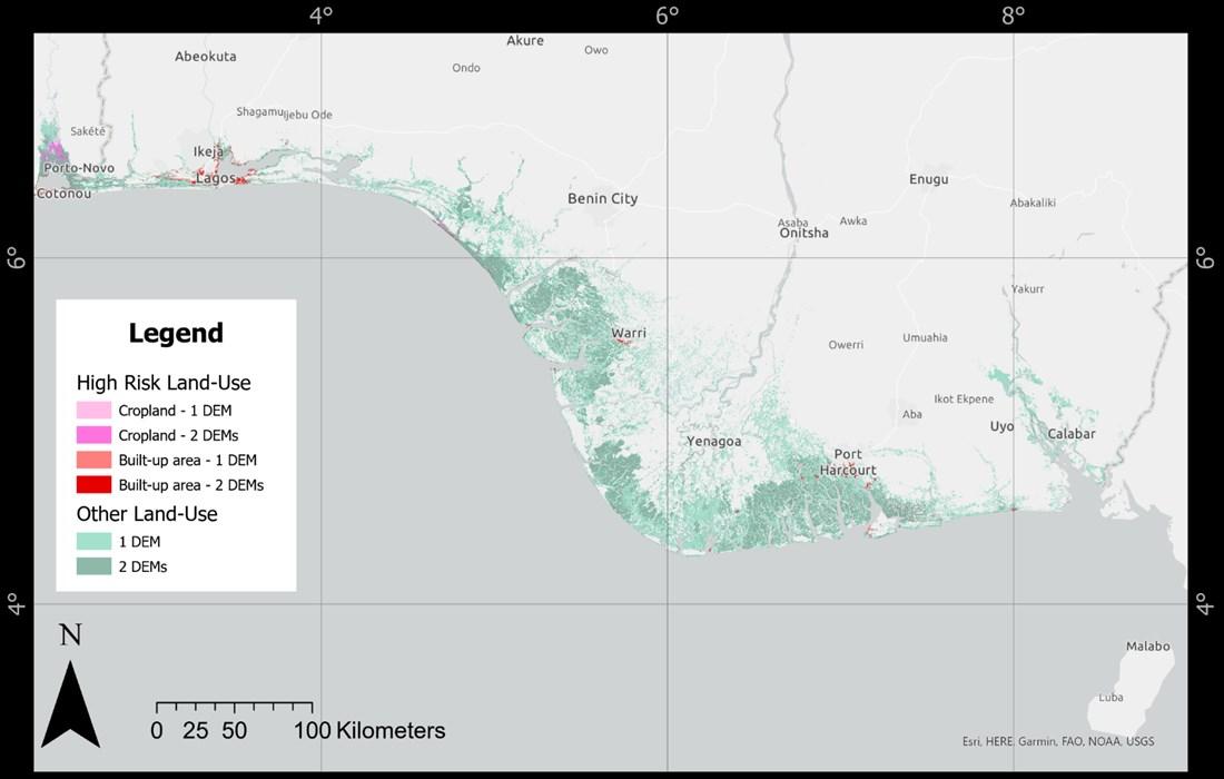
Figure16. Lowly-elevatedcoastalareas(elevation<2mabovelocalmeansea-level)inWarri.
Location of lowly-elevated coastal areas (elevation < 2 m above local mean sea-level), classified according to land-use types, in WarriaccordingtotheDEMs FABDEMand CoastalDEM v2.1. Land-usetypes aretakenfrom Zanagaet al.(2021)
26
< 2 m above local mean sea-level),
lowly-elevated coastal areas (elevation < 2 m above local mean sea-level), classified according to land-use types, in
27
Figure17. Lowly-elevatedcoastalareas(elevation<2mabovelocalmeansea-level)inWarri.
Location of lowly-elevated coastal areas (elevation
classified according to land-use types, in PortHarcour accordingtotheDEMsFABDEMand CoastalDEM v2.1.Land-usetypesaretakenfrom Zanagaet al.(2021)
Figure18. Lowly-elevatedcoastalareas(elevation<2mabovelocalmeansea-level)inWarri.
Location of
Lagosarea accordingtotheDEMs FABDEMand CoastalDEM v2.1. Land-usetypes aretakenfrom Zanaga etal.(2021)
3. Discussion
3.1. DEMperformances
ThecoastalcommunitiesandecosystemsalongtheGulfofGuineaareincreasinglyfacingchallenges in averting impeding hazards driven by global climate change and direct impacts from local human interventions (Almar et al., 2022). The scale of vulnerability to hazards and coastal changes has been difficult to assess due to limited spatially explicit understanding of local and regional processes and the challenges of obtaining detailed data. Recent advances in satellite remote sensing for digital elevation mapping has opened opportunities to address data gaps withspatially continuous coastal informationfromspace-bornesensors.Globalsatellite-baseddatasetsincreasinglyofferhighspatial resolution (~30 m), calibration with varying degrees of global representativeness, and algorithms to remove tree height biases and buildings (see overview in Table 2). In this scoping study, we ingested data from five global satellite-based DEMs; CoastalDEM version 1.1, CoastalDEM version 2.1, SRTM-ACE2, ALOSDEM(AW3D30),and FABDEM.
The global satellite-based DEMs were vertically referenced to the same global geoid model (EGM96) toenablecomparison.Firstly,weshowtheimportanceofcorrectingtolocalsealevelasfortheGulfof Guinea which deviate between 0.1 and 0.7 m above the presumed global sea level average based on theEGM96geoid.Secondly,comparisonoftheshorelineprofilesderivedfromthedifferentDEMsleads to results that can differ several meters. The limited agreeability between DEMs emphasizes the need for vigilance when purely relying on satellite-based coastal elevation estimates. Taken together, the initial results of the geospatial elevation study conducted here underpins that the message of global satellite based DEMs needs to be met with caution in low-lying and flat coastal regions (Minderhoud etal.,2019).
We found that in this region the availability of relevant in-situ measurements to validate the spaceborne observations is scarce, hard to access and poorly documented. With the wide range of differencesincoastalelevationestimatesbydifferentDEMs,suchinformationiscrucialtounderstand the size of vertical error and uncertainty, to assess the quality of the different DEMs for application in the Gulf of Guinea, and facilitate local/regional calibration. Based on a limited (N=6) yet thoroughly measured ground control points in the Volta Delta (Ghana), we find an average error size (RMSE) of between1.5and2.9mdependingontheDEMdeployedforanalysis.Furthervalidationacrosstheother countriesandregionsoftheGulfofGuineaisneeded.Moreover,amuchlargerdatasetofgroundtruth control pointsisrequired todrawsolidconclusions ontheperformanceof thedifferentDEMsforthis.
Acrossglobaldatasets,theconfidenceincoastalelevationestimationandtheassessmentofcoastal vulnerabilities against relative sea-level rise projections is generally constraining (Minderhoud et al., 2019). The accuracy of satellite radar data remains relatively low. In our study, CoastalDEM v2.1 has an accuracy of about 1.6 m (RMSE) against our GCPs, which is in correspondence to the RSME of ~1.4m (CoastalDEMv2.1)reportedbyVernimmenatal.(2020)for threevalidationsites(Vietnam,Netherlands and Florida) reports. Newer satellite-based DEMs or version of improved error-removal are continuously being developed and released (Hawker et al., 2022). In combination with field data, this leaves potential for ensemble and calibration techniques to locally optimize the estimates of global satellite-based DEMs. Potentially even more promising is the increasing availability of satellite-based LiDAR data which generally holds an improved accuracy compared to satellite radar based DEMs (Vernimmenetal.,2020).Recently,Hooijer&Vernimmen(2021)havereleasedglobalLiDARlowlandDTM (GLL_DTM_v1) at 0.05-degree resolution which currently still contains vertical reference conversion flaws (Seegers et al., 2023). The newest version (GL_DTM_v2) published during the final preparation of this report (Vernimmen & Hooijer, 2023), reportedly greatly improve both horizontal as vertical accuracy,whichprovidesa promise tofuturecoastalelevationassessments.
Inthisreport,topreliminarilyassess thevulnerabilityofdifferentregions tocoastal changes,we relied on an analysis based on two of the more recent DEMs: CoastalDEM_v2.1 and FABDEM. These datasets
28
providecoastalelevationinformationathighspatialresolution(30m),offeralgorithmstoremovetree height biases (FABDEM: also buildings), and ingest global ancillary data for the calibration of the underlyingdigitalelevationmodels(seeTable2foranoverview).Moreover,basedonthesmallsample size validation, CoastalDEM_V2.1 and FABDEM performed above-average in absolute (in meters), and relative(profileofelevation)coastalelevationassessment(Figures8and9).Yet,theseconclusionsare based onsixgroundcontrol pointsonlythereforenotconclusivebutindicativeonly.
3.2. Coastalvulnerabilitytorelativesea-levelriseandhotspotanalysis
TheassessmentofareasofpotentialvulnerabilitytorSLRwasconductedbyfocusingoncoastalareas elevatedbelow2-mLSLasobservedthroughtherespectiveFABDEMandCoastalDEM_v2.1.Weapplied bothamoreprecautionaryapproachwhichconsidersallareasidentifiedbelow2-mLSLbyeitherDEM aswellasahighercertaintycross-validatedapproachwhichhighlightsareasbelow2-mLSLidentified by both DEMs. With the exception of the coastline of Côte d’Ivoire, large spatial agreement can be observed between CoastalDEM v2.1 and FABDEM for the areas below 2 m in Ghana, Togo, Benin and Nigeria.
Secondly,thecoastalelevationdatawascombinedwithlandcoverinformation.Emphasiswasplaced onurbanlandandcroplandasademographicproxyand theselandcovertypesareassociatedwith higher risks in terms of anthropogenically-induced land subsidence. Large capital cities and major metropolitan hubs were found to be near the coast and elevated below 2-m LSL. We specifically highlight; 1) Lagos, a megacity, with large parts below 2-m LSL as identified by both FABDEM and CoastalDEMv2.1; 2) other cities within Nigeria such as the greater Lagos area, Bonny, Warri, Port Harcourt; 3) Benin’s capital Cotonou enclosed between the Atlantic Ocean and Lake Nokoué; 4) WesternAccrainGhana;5)andurbanareassurroundingtheEbrielagoonwithinAbidjan,CoteD’Ivoire. In addition to the geospatial analysis, the literature review on land subsidence highlights observed hotspots in Lagos, Niger delta, Port Harcourt, Warri and Volta delta. No specific studies were found about land subsidence in Abidjan, Accra, Togo and Benin areas that were indicated as affected by subsidencebyCianetal. (2019)
While built up area and cropland were emphasized in the analysis, other land use types can still be highlyvulnerabledespitebeinglessextensivelypopulated,inparticular,inconsiderationofbiodiversity and ecosystem services (Furlan et al., 2022; Tregarot, 2021) Large rural areas of the Niger delta are subject to subsidence due to oil and gas (hydrocarbon) extraction and the withdrawal from underground aquifers imposed heighted vulnerability to these low-lying regions (Ericson et al., 2006; Fabiyi &Enaruvbe 2014)
29
4. Futureoutlookandconclusions
Theseeffortstoimproveourestimatesoncoastalelevationarevaluableandverytimelyforthisregion, asassessmentsofverticallandmovementbyInSAR(InterferometricSyntheticApertureRadar)forthe entire coastline of the Gulf of Guinea are performed currently in the ENGULF project. This will improve our understanding on the spatial (and temporal) contemporary coastal subsidence which in combination with coastal elevation will enable to include for the first time land subsidence in future rSLRprojectionsand improve coastalvulnerabilityassessments.
The lack of specific hydrogeologic information and uncertainty in the actual coastland elevation presently hampers our ability to understand the mechanisms responsible for the observed land movements(e.g.byInSAR)anddevelopingscenariosofcoastalhazardandriskoverthenextdecades.
Theinclusionoflandcovertopredictvulnerabilitiesshouldbeexpandedtofullyunderstandthespatial relationships between elevation, land use and land subsidence potential to assess coastal vulnerability. Future analysis needs to include a wider range of spatially explicit information on population densities, major infrastructure, the distinction between different types of cropland (irrigated vs. non-irrigated), the extraction of groundwater and other underground fluids (e.g. hydrocarbons), coastal buffers including mangrove forests, coastal erosion/accreditation dynamics, and relevant geological information based on sedimentation and soil types. Rocky and sandy shores will respond differently to extraction of subsurface fluids with negligible or possibly significant subsidence rates. Including this information will improve future analyses. However, data availability, reliabilityandespeciallyhighresolutionspatiallycontinuousdatawillbechallengingtoacquireforthis region.
Toconclude,wesummarizethefollowingmessagesfromthispreliminaryscopinganalysisoncoastal elevationfor theGulf ofGuinea:
- Satellite-basedDEMsprovideafirstindicationsofthelow-lyingcoastalareasalongtheGulfof Guinea
- Estimates between DEMs differ considerably (> 1 m), which highlights the importance of validation (e.g. ground truthing) or advanced approaches incorporating multiple DEMs in the absence ofground-truthdata,asdone inthisstudy.
- Ground-truth data for the Gulf of Guinea is very scarce. This emphasizes the value of future field campaigns (e.g. monitoring or installing GPS stations) and the sharing of available data betweenrelevantinstitutes.
- Incorporation of the newest published LiDAR DEM (Vernimmen & Hooijer, 2023) and other satellite optical missions (e.g. Pleiades, Pleiades Neo) is expected to improve future assessmentsfurther.
- SeveralcoastalhotspotsofvulnerabilitytorSLRalongthecoasthavebeenidentifiedbasedon the combination of the FABDEM and CoastalDEM_v2.1 in conjunction with land cover data. These include:Lagosandits greater metropolitanarea,theNigerDeltaincludingBonny,Warri, Port Harcourt (Nigeria), Cotonou (Benin), Western Accra, the Volta region (Ghana), and the urbanareassurrounding the Ebrie lagoonwithinAbidjan(CoteD’Ivoire).
- Here, only static morphologies were considered while this stretch of soft material coast is undergoing a massive erosion (up to tens of meters per year) under climate and anthropogenic influences. It is thus key to set an efficient monitoring plan at regional scale from satellite with revisit to also account for morphological evolution in any risk assessment evolution(Taveneauetal. (2021);Almar etal.(2022);Vousdoukasetal.,(2022)).
30
Urbanized areas and cropland as a demographic and “risk” proxy can be expanded in future vulnerability assessments taking into consideration present land subsidence rates, hydrogeological setting,populationdensities,major infrastructuresamong other geospatialinformation.
31
References
ABIDIN,H.Z.,ANDREAS,H.,GUMILAR,I., FUKUDA,Y.,POHAN,Y.E.,&DEGUCHI, T.(2011).Landsubsidenceof Jakarta(Indonesia) andits relationwithurban development.Naturalhazards, 59, 1753-1771.
ABIJA,F.A.,ABAM,T.K.S.,TEME,S.C., &EZE,C.L.(2020). Ground SubsidenceandIntermontane TopographicDepressionsabove aProducingOilfield:ALinkto FloodVulnerability intheNiger DeltaBasin,Nigeria. J EarthSci Clim Change,11:9.of, 10,6-7
ABAM,T.K.S.(2001). Regional hydrological research perspectives intheNigerDelta. HydrologicalSciencesJournal, 46(1),13-25.
ABESSOLO,G.O.,LARSON,M.,& ALMAR,R.(2021). Modelingthe BightofBenin(GulfofGuinea, WestAfrica)coastlineresponse tonatural andanthropogenic forcing.RegionalStudiesin MarineScience, 48, 101995.
ADDO,K.A.(2013).Assessing coastalvulnerabilityindexto climatechange:Thecase of Accra–Ghana.Journal of Coastal Research,(65(10065)), 1892-1897.
ADDO,K.A.,&ADEYEMI,M.(2013). Assessingtheimpactofsealevelriseonavulnerablecoastal communityinAccra,Ghana. Journal ofDisasterRiskStudies, 5(1),1-8.
ADDO,K.A.(2015).Monitoringsea levelrise-inducedhazards along thecoastofAccrainGhana. Natural Hazards,78(2),1293-1307.
ADDO,K.A.,WALKDEN,M.,&MILLS,J. T.(2008).Detection, measurementandpredictionof shoreline recessioninAccra, Ghana.ISPRSJournal of PhotogrammetryandRemote Sensing,63(5),543-558.
ADDO,K.A.,NICHOLLS,R.J.,CODJOE, S.N.A.,&ABU,M.(2018). A biophysical andsocioeconomic reviewofthe Voltadelta, Ghana. Journal ofCoastalResearch, 34(5), 1216-1226.
ALMAR,R.,KESTENARE,E.,REYNS,J., JOUANNO,J.,ANTHONY,E.J.,LAIBI,R., HEMER,M.,DUPENHOAT,Y.AND RANASINGHE,R.(2015) Responseof theBightofBenin(Gulf ofGuinea, WestAfrica)coastlineto anthropogenic andnatural forcing,Part1:Waveclimate variability andimpactsonthe longshoresedimenttransport. ContinentalShelf Research, 110, pp.48-59.
ALMAR,R.,RANASINGHE,R.,BERGSMA, E.W.,DIAZ,H.,MELET,A.,PAPA,F.,...& KESTENARE,E.(2021).Aglobal analysisofextremecoastal waterlevelswithimplications for potentialcoastalovertopping. Naturecommunications, 12(1), 3775.
ALMAR,R.,STIEGLITZ,T.,ADDO,K.A., BA,K.,ONDOA,G.A.,BERGSMA,E.W., &ARINO,O.(2022).Coastalzone changesinWestAfrica: challenges andopportunitiesfor satelliteearthobservations. Surveysin Geophysics,1-27.
ALMEIDA,L.P.,ALMAR,R.,BERGSMA,E. W.,BERTHIER,E.,BAPTISTA,P.,GAREL, E.,...&ALVES,B.(2019). Deriving highspatial-resolution coastal topographyfrom sub-meter satellitestereo imagery.Remote Sensing, 11(5),590.
ALVES,B.,ANGNUURENG,D.B., MORAND,P.,&ALMAR,R.(2020).A reviewoncoastal erosionand floodingrisksandbest managementpractices inWest Africa: whathas beendone and shouldbe done.Journal of CoastalConservation, 24(3),1-22.
AMAN,A.,TANO,R.A.,TOUALY,E., SILUÉ,F.,ADDO,K.A.,&FOLORUNSHO, R.(2019). Physicalforcing inducedcoastalvulnerability alongthe GulfofGuinea. Journal ofEnvironmentalProtection 10(9), 1194-1211.
ANTHONY,E.J.,ALMAR,R.,BESSET,M., REYNS,J.,LAIBI,R.,RANASINGHE,R.,... &VACCHI,M.(2019). Responseof theBightofBenin(Gulf ofGuinea, WestAfrica)coastlineto anthropogenic andnatural forcing,Part2:Sources and patternsofsedimentsupply, sedimentcells,andrecent shorelinechange.Continental ShelfResearch,173,93-103.
AVORNYO,S.Y.,APPENNINGADDO,K., TEATINI,P.,MINDERHOUD,P.&WOILLEZ M.-N.(2023).Vulnerability ofGhana’sCoasttoRelative Sea-levelRise:AScopingReview. AFDresearchpaper n°282
BERRY,P.A.M.,SMITH,R.G.,& BENVENISTE,J.(2010). ACE2: the newglobaldigitalelevation model.In Gravity, Geoidand EarthObservation:IAG Commission2:Gravity Field, Chania,Crete,Greece,23-27 June 2008(pp.231-237).Springer BerlinHeidelberg.
BOATENG,I.,WIAFE,G.,&JAYSONQUASHIGAH,P.N.(2016).Mapping vulnerabilityandriskofGhana’s coastlinetosealevelrise.Marine Geodesy,40(1),23-39.
BROWN,S.,KEBEDE,A.S.,&NICHOLLS, R.J.(2011).Sea-levelrise and impactsinAfrica,2000to2100. SchoolofCivilEngineeringand the EnvironmentUniversity of Southampton, UK.
CIAN,F.,BLASCO,J.M.D.,&CARRERA, L.(2019).Sentinel-1formonitoring landsubsidence ofcoastalcities inAfricausingPSInSAR: a methodologybasedonthe integrationofSNAPandStaMPS. Geosciences,9(3), 124.
32
CROITORU,L.,MIRANDA,J.J.,& SARRAF,M.(2019).TheCostof CoastalZone Degradationin WestAfrica.WestAfricaCoastal AreasManagementProgram, WorldBankGroup
DADA,O.,ALMAR,R.,MORAND,P.,& MÉNARD,F.(2021).TowardsWest Africancoastalsocialecosystemssustainability: Interdisciplinaryapproaches. Ocean& CoastalManagement, 211, 105746.
DANLADI,I.B.,KORE,B.M.,&GÜL,M. (2017).Vulnerabilityofthe Nigeriancoast:Aninsightinto sealevelrise owingtoclimate changeandanthropogenic activities.JournalofAfricanEarth Sciences,134,493-503.
DASGUPTA,S.,LAPLANTE,B.,MEISNER, C.,WHEELER,D.,&YAN,J.(2007). The impactofsealevelriseon developingcountries: a comparativeanalysis.World BankPolicyResearch Working Paper4136.
DIAZ,H.,ALMAR,R.,BERGSMA,E.W.,& LEGER,F.(2019).Ontheuse of satellite-basedDigitalElevation Models todeterminecoastal topography.InIGARSS2019-2019 IEEEInternationalGeoscience andRemoteSensingSymposium (pp.8201-8204).IEEE.
DOGANALP,S.,&SELVI,H.Z.(2015). Localgeoiddeterminationin stripareaprojectsbyusing polynomials, least-squares collocationandradialbasis functions.Measurement,73, 429-438.
DOSSOU,K.M.,&GLEHOUENOUDOSSOU,B.(2007). The vulnerabilitytoclimatechange ofCotonou(Benin)therise insea level.Environmentand Urbanization, 19(1),65-79.
ERICSON,J.P.,VÖRÖSMARTY,C.J., DINGMAN,S.L.,WARD,L.G.,& MEYBECK,M.(2006).Effectivesealevelriseanddeltas:Causesof changeandhumandimension implications.Global and PlanetaryChange, 50(1-2),63-82.
EVADZI,P.I.,ZORITA,E.,&HÜNICKE,B. (2017).Quantifyingand predictingthecontributionof sea-levelrise toshoreline changeinGhana: Information forcoastaladaptation strategies.Journal ofCoastal Research,33(6),1283-1291.
EVADZI,P.I.,SCHEFFRAN,J.,ZORITA,E., &HÜNICKE,B.(2018).Awarenessof sea-levelresponseunder climatechangeonthecoastof Ghana.JournalofCoastal Conservation,22(1),183-197.
FABIYI,O.O.,&ENARUVBE,G.O. (2014).CoastalLandSubsidence andMorphologicalChanges withinNigerianCoastalAreas. Journal ofGeospatial Science andTechnology, 1(1),146-160.
FASHAE,O.A.,&ONAFESO,O.D. (2011).Impactofclimatechange onsealevel rise inLagos,Nigeria. InternationalJournal ofRemote Sensing,32(24),9811-9819.
FOROUGHI,I.,SAFARI,A.,NOVÁK,P.,& SANTOS,M.C.(2018).Application ofradial basisfunctionsfor heightdatumunification. Geosciences,8(10),369.
FURLAN,E.,DEREPASKO,D.,TORRESAN, S.,PHAM,H.V.,FOGARIN,S.,&CRITTO, A.(2022).Ecosystemservicesat riskinItalyfromcoastal inundationunderextremesea levelscenariosupto2050:A spatiallyresolvedapproach supportingclimatechange adaptation.Integrated EnvironmentalAssessmentand Management,18(6),1564-1577.
GIARDINO,A.,SCHRIJVERSHOF,R., NEDERHOFF,C.M.,DEVROEG,H., BRIERE,C.,TONNON,P.K.,...&SLOFF, C.J.(2018). Aquantitative assessmentofhuman interventionsandclimate changeontheWestAfrican sedimentbudget.Ocean& CoastalManagement, 156,249265.
GUERRERA,F.,MARTIN-MARTIN,M., TRAMONTANA,M.,NIMON,B.,& ESSOTINAKPEMOUA,K.(2021). Shorelinechanges andcoastal
erosion:Thecasestudyofthe coastoftogo(bightofbenin, westafricamargin). Geosciences, 11(2),40.
HAWKER,L.,UHE,P.,PAULO,L.,SOSA,
J.,SAVAGE,J.,SAMPSON,C.,&NEAL,J. (2022).A30mglobalmapof elevation withforests and buildingsremoved.
Environmental ResearchLetters, 17(2), 024016.
HECKMANN,M.,BRUGERON,A.,O
DOCHARTAIGH,B.,&LEWIS,M.(2022). Groundwaterresourcesinthe ECOWASregion:expected aquiferproductivity.
HERRERA-GARCÍA,G.,EZQUERRO,P.,
TOMAS,R.,BÉJAR-PIZARRO,M.,
LÓPEZ-VINIELLES,J.,ROSSI,M.,
MATEOS,R.M.,CARREÓN-FREYRE,D.,
LAMBERT,J.,TEATINI,P.,CABRAL-
CANO,E.,ERKENS,G.,GALLOWAY,D.,
HUNG,W.C.,KAKAR,N.,SNEED,M.,
TOSI,L.,WANG,H.,&YE,S.(2021). Mappingtheglobalthreatof landsubsidence.Science, 371(6524),34–36.
HOOIJER,A.,&VERNIMMEN,R.(2021). GlobalLiDARlandelevationdata revealgreatestsea-levelrise vulnerabilityinthetropics. Naturecommunications, 12(1),1-7.
IBE,A.C.ANDQUELENNEC,R.E.(1989). Méthodologied’inventaireetde contrôledel’érosioncôtière danslaregiondel’Afriquede l’Ouestetducentre,
IDOWU,T.E.,&HOME,P.(2015). Probableeffectsofsealevelrise andlandreclamationactivities oncoastlines andwetlands of LagosNigeria.In: The2015JKUAT Scientific Conference.JKUAT, Nairobi,pp207–220.
IKUEMONISAN,F.,OZEBO,V.C., MINDERHOUD,P.S.J,TEATINI,P.& WOILLEZ,M.-N.(2023).Ascoping reviewofthe vulnerabilityof Nigeria'scoastlandtosea-level rise andthecontribution oflandsubsidence.
AFDResearchPapern°284
33
IKUEMONISAN,F.E.,&OZEBO,V.C. (2020). Characterisationand mappingoflandsubsidence basedongeodeticobservations inLagos,Nigeria.Geodesy and Geodynamics,11(2), 151-162.
IKUEMONISAN,F.E.,OZEBO,V.C.,& OLATINSU,O.B.(2021A). Investigatingandmodelling groundsettlementresponseto groundwater dynamic variation inpartsofLagosusingspacebasedretrievals.SolidEarth Sciences,6(2),95-110.
IKUEMONISAN,F.E.,OZEBO,V.C.,& OLATINSU,O.B.(2021B). InvestigationofSentinel-1derivedlandsubsidenceusing wavelettoolsandtriple exponentialsmoothing algorithminLagos,Nigeria. EnvironmentalEarthSciences 80(21), 1-17.
JAPANAEROSPACEEXPLORATION
AGENCY(2021).ALOSWorld3D30 meter DEM.V3.2,Jan2021. DistributedbyOpenTopography. https://doi.org/10.5069/G94M92H B.Accessed:2022-10-07.
JONAH,F.E.,MENSAH,E.A.,EDZIYIE,R. E.,AGBO,N.W.,&ADJEI-BOATENG,D. (2016). CoastalerosioninGhana: Causes, policies,and management.Coastal Management,44(2),116-130.
JONAH,F.E.,ADAMS,O.,AHETO,D.W., JONAH,R.E.,&MENSAH,E.A.(2017). Coastalzonemanagement challenges inGhana:issues associatedwithcoastal sedimentmining.Journal of CoastalConservation, 21(3),343353.
KULP,S.A.,&STRAUSS,B.H.(2019). Newelevationdatatriple estimates ofglobalvulnerability tosea-levelriseandcoastal flooding.Nature communications,10(1), 1-12.
KULP,S.A.,&STRAUSS,B.H.(2021). CoastalDEMv2.1: Ahighaccuracyandhigh-resolution globalcoastalelevationmodel trainedonICESat-2satellitelidar.
MAHMUD,M.U.,YAKUBU,T.A., ADEWUYI,T.O.,SOUSA,J.J.,RUIZ ARMENTEROS,A.M.,BAKON,M.,...& PERISSIN,D.(2016A). Subsidence monitoringinthecoastalregion ofNigeriausingmultitemporal interferometricsynthetic apertureradar(MT-InSAR).Proc. ‘LivingPlanetSymposium2016’, Prague,CzechRepublic 9–13May2016.
MAHMUD,M.U.,YAKUBU,T.A., OLUWAFEMI,O.,SOUSA,J.J.,RUIZARMENTEROS,A.M.,ARROYO-PARRAS, J.G., &PERISSIN,D.(2016B). Applicationofmulti-temporal interferometricsynthetic apertureradar(MT-InSAR) technique tolanddeformation monitoringinWarriMetropolis, DeltaState,Nigeria.Procedia Computer Science, 100,1220-1227.
MARTI,F.,CAZENAVE,A.,BIROL,F., PASSARO,M.,LÉGER,F.,NIÑO,F.,…& LEGEAIS,J.F.(2021).Altimetrybasedsealeveltrends alongthe coastsofwesternAfrica. AdvancesinSpaceResearch 68(2),504-522.
MELET,A.,ALMAR,R.,&MEYSSIGNAC, B.(2016).Whatdominatessea levelatthecoast:acasestudy for theGulf ofGuinea.Ocean Dynamics,66(5),623-636.
MINDERHOUD,P.S.J.,ERKENS,G., PHAM,V.H.,BUI,V.T.,ERBAN,L.,KOOI, H.,&STOUTHAMER,E.(2017). Impactsof25years of groundwaterextractionon subsidence inthe Mekongdelta, Vietnam.Environmental researchletters, 12(6),064006.
MINDERHOUD,P.S.J.,COUMOU,L., ERKENS,G.,MIDDELKOOP,H.,& STOUTHAMER,E.(2019).Mekong deltamuchlowerthan previouslyassumedinsea-level rise impactassessments.Nature communications,10(1),3847.
MUSA,Z.N.,POPESCU,I.,&MYNETT,A. (2014).TheNiger Delta’s vulnerabilitytoriverfloods due tosealevel rise.NaturalHazards andEarthSystemSciences, 14(12),3317-3329.
MUSA,Z.N.,POPESCU,I.I.,&MYNETT, A.(2015A).Sensitivityanalysisof the 2DSOBEKhydrodynamic modeloftheNiger River.InIAHR WorldCongress,Hague.
MUSA,Z.N.,POPESCU,I.,&MYNETT,A. (2015B). Areviewofapplications ofsatelliteSAR,optical,altimetry andDEMdataforsurfacewater modelling,mappingand parameterestimation.Hydrology andEarthSystemSciences, 19(9), 3755-3769.
MUSA,Z.N.,POPESCU,I.,&MYNETT,A. (2016).Approachonmodeling complexdeltasindatascarce areas: acasestudy ofthelower Niger delta.Procedia Engineering, 154,656-664.
MUSA,Z.(2018). Satellite-Based MitigationandAdaptation Scenariosfor SeaLevelRisein the LowerNigerDelta.CRCPress.
NICHOLLS,R.J.,LINCKE,D.,HINKEL,J., BROWN,S.,VAFEIDIS,A.T., MEYSSIGNAC,B.,...&FANG,J.(2021). Aglobalanalysis ofsubsidence, relativesea-levelchange and coastalfloodexposure.Nature Climate Change,11(7),634-634.
OHENHEN,L.O.,&SHIRZAEI,M.(2022). Landsubsidence hazardand buildingcollapseriskinthe coastalcity ofLagos,WestAfrica. Earth'sFuture, 10,e2022EF003219.
OLOYEDE,M.O.,WILLIAMS,A.B.,ODE, G.O.,&BENSON,N.U.(2022).
CoastalVulnerability
Assessment: ACase Study ofthe NigerianCoastline. Sustainability 14(4),2097.
ONWUTEAKA,J.(2014). GIS modelingoffloodingexposurein Nigeriancoastalareasfromsea levelrise.J.Environ.EarthSci,4, 81-94.
OZER,P.,HOUNTONDJI,Y.C.,&DE LONGUEVILLE,F.(2017). Evolution récentedu traitdecôtedansle golfeduBénin.ExemplesduTogo et duBénin.Geo-Eco-Trop:Revue Internationale de Géologie,de Géographieetd'Écologie Tropicales,41(3).
34
PRLEC-UEMOA(2010). Shoreline MonitoringStudy andWest AfricanLittoral'sGuidingScheme towardaRegionalPlanfor CoastlineRiskPrevention
SALAMEH,E.,FRAPPART,F.,ALMAR,R., BAPTISTA,P.,HEYGSTER,G.,LUBAC,B., &LAIGNEL,B.(2019).Monitoring beachtopographyand nearshore bathymetryusing spaceborneremotesensing: A review.RemoteSensing, 11(19), 2212.
SEEGER,K.,MINDERHOUD,P.S.J., PEFFEKÖVER,A.,VOGEL,A.,BRÜCKNER, H.,KRAAS,F., &BRILL,D.(2023). Assessinglandelevationinthe AyeyarwadyDelta(Myanmar) anditsrelevanceforstudying sealevelrise anddeltaflooding. EGUsphere,1-42.
SHIRZAEI,M.,FREYMUELLER,J., TÖRNQVIST,T.E.,GALLOWAY,D.L., DURA,T.,&MINDERHOUD,P.S.J. (2020).Measuring, modelling andprojectingcoastalland subsidence.NatureReviews Earth&Environment,2(1),40–58.
TANO,R.A.,AMAN,A.,KOUADIO,K.Y., TOUALY,E.,ALI,K.E.,&ASSAMOI,P. (2016).AssessmentoftheIvorian coastalvulnerability. Journalof CoastalResearch,32(6),14951503.
TAVENEAU,A.,ALMAR,R.,BERGSMA,E. W.,SY,B.A.,NDOUR,A.,SADIO,M.,& GARLAN,T.(2021). Observingand predictingcoastal erosionatthe LanguedeBarbariesandspit aroundSaintLouis(Senegal, WestAfrica)throughsatellitederiveddigitalelevationmodel andshoreline.RemoteSensing, 13(13),2454.
TAY,C.,LINDSEY,E.O.,CHIN,S.T., MCCAUGHEY,J.W.,BEKAERT,D., NGUYEN,M.,...&HILL,E.M.(2022). Sea-levelrisefromland subsidence inmajorcoastal cities NatureSustainability,1-9.
TESSLER,Z.D.,VÖRÖSMARTY,C.J., GROSSBERG,M.,GLADKOVA,I., AIZENMAN,H.,SYVITSKI,J.P.,& FOUFOULA-GEORGIOU,E.(2015). Profilingriskandsustainabilityin coastaldeltas ofthe world. Science,349(6248),638-643.
TREGAROT,E.,CAILLAUD,A.,CORNET, C.C.,TAUREAU,F.,CATRY,T.,CRAGG, S.M.,&FAILLER,P.(2021). Mangrove ecologicalservicesatthe forefrontofcoastalchangein the Frenchoverseasterritories. ScienceoftheTotal Environment, 763, 143004.
UDOH,J.C.,&UDOFIA,E.P.(2014). LandSubsidenceMonitoring UsingGeographic Information System(GIS)Techniques inAkwa IbomState,Nigeria.Current WorldEnvironment,9(1), 1.
UEMOA(2017).Bilan2016. Littorauxd’Afrique del’Ouest. Documentgeneral. https://www.wacaprogram.org/si tes/waca/files/knowdoc/Littorau x%20d%27Afrique%20de%20l%27O uest%20document%20general%2 0Version%20Francaise.pdf
UKO,E.D.,FAMUYIBO,D.A.,& OKIONGBO,K.(2018). Estimationof LandSurfaceSubsidence InducedbyHydrocarbon ProductionintheNigerDelta, Nigeria,usingTime-Lapse OrthometricLevelingData. MediterraneanJournalofBasic andAppliedSciences,2(3), 1-18.
UNITEDNATIONS,DEPARTMENTOF ECONOMICANDSOCIALAFFAIRS, POPULATIONDIVISION(2018).World UrbanizationProspects:The2018 Revision.
UNITEDNATIONSENVIRONMENT PROGRAMME(1985).Coastal ErosioninWestandCentral Africa.UNEPRegionalSeas Reports andStudiesNo.67 https://wedocs.unep.org/20.500.11 822/29369.
VERNIMMEN,R.,HOOIJER,A.,&PRONK, M.(2020). NewICESat-2satellite LiDARdataallowfirstglobal lowlandDTMsuitablefor accuratecoastalfloodrisk assessment.RemoteSensing, 12(17),2827.
VERNIMMEN,R.,&HOOIJER,A.(2023). NewLiDAR-basedelevation modelshowsgreatestincrease inglobalcoastalexposureto floodingtobecausedbyearlystagesea-levelrise.Earth's Future,11,e2022EF002880.
VOUSDOUKAS,M.I.,CLARKE,J., RANASINGHE,R.,REIMANN,L.,KHALAF, N.,DUONG,T.M.,...&SIMPSON,N.P. (2022).Africanheritagesites threatenedassea-levelrise accelerates.Nature Climate Change,12(3),256-262.
WESSEL,P.,&SMITH,W.H.(1996).A GLOBAL,SELF‐CONSISTENT, hierarchical, high‐resolution shoreline database.Journalof Geophysical Research:Solid Earth,101(B4),8741-8743.
WU,P.C.,WEI,M.,&D’HONDT,S. (2022).Subsidenceincoastal citiesthroughoutthe world observedbyInSAR.Geophysical ResearchLetters,49(7), e2022GL098477.
ZANAGA,D.,VANDEKERCHOVE,R.,DE KEERSMAECKER,W.,SOUVERIJNS,N., BROCKMANN,C.,QUAST,R.,...& ARINO,O.(2021).ESAWorldCover 10m2020v100.Zenodo.
Zhang,J.Z.,Huang,H.J.,&Bi,H. B.(2015). Landsubsidenceinthe modernYellowRiverDeltabased onInSARtimeseries analysis. Natural Hazards,75(3), 23852397.
35
AcronymsandAbbreviations
ALOS-PRISM AdvancedLand ObservingSatellite –Panchromatic Remote-sensingInstrumentfor StereoMapping
DEM Digital ElevationModel
DTM Digital TerrainModel
ENGULF CoastallandsubsidENceintheGULFof Guinea
FABDEM ForestAndBuildingsdisabled Copernicus DEM
GCM General CirculationModel
GCP Ground Control Point
GPS Global PositioningSystem
GSHHG GlobalSelf-consistent,Hierarchical,High-resolutionGeographicdatabase
InSAR InterferometricSyntheticAperture Radar
LiDAR LightDetectionAndRanging
LSL LandSurfaceLevel
MDT MeanDynamic Topography
MAE MeanAbsolute Error
RCP Representative ConcentrationPathway
RMSE RootMeanSquareError
rSLR relativeSea-LevelRise
SBAS Satellite-BasedAugmentationSystems
SLR Sea-Level Rise
SNAP SentinelApplicationPlatform
SRTM ShuttleRadarTopographyMission
StaMPS StanfordMethodforPersistentScatterers
UNEP UnitedNations EnvironmentProgramme
WACA WestAfrican CoastalAreasManagementProgram
36
37 Appendix
Authors Title DOI Keywords Land subside nce Coastal vulnerabi lity Sea level rise Accreti on/Erosi on Abam(2001) Regionalhydrological researchperspective intheNigerDelta https://doi.org/10.1080/02 626660109492797 0 0 0 1 Addo(2013) AssessingCoastal VulnerabilityIndexto Climate Changethe CaseofAccra–Ghana https://doi.org/10.2112/SI6 5-320.1 1 1 1 1 Addoand Adeyemi (2013) Assessingtheimpact ofsea-levelriseona vulnerable coastalcommunity inAccra, Ghana http://dx.doi.org/10.4102/j amba.v5i1.60 0 0 1 1 Addo(2015) Monitoringsealevel rise-inducedhazards along thecoastofAccrain Ghana https://doi.org/10.1007/s11 069-015-1771-1 0 0 1 1 Addoetal. (2008) Detection, measurementand predictionof shoreline recessioninAccra, Ghana https://doi.org/10.1016/j.is prsjprs.2008.04.001 0 0 1 1 Addoetal. (2018) ABiophysical and Socioeconomic Reviewof theVoltaDelta, Ghana https://doi.org/10.2112/JC OASTRES-D-17-00129.1 1 0 1 1 Alvesetal. (2020) Areviewoncoastal erosionandflooding risks andbest management practicesinWest Africa: whathas been doneandshouldbe done https://doi.org/10.1007/s11 852-020-00755-7 0 0 1 0 Amanetal. (2019) PhysicalForcing InducedCoastal https://doi.org/10.4236/je p.2019.109071 0 1 1 1
Table A.1. List of the papers included in the literature database. For each paper, the tagged keywords are indicatedusingthenumberone.
38 Vulnerability alongthe Gulfof Guinea Anthonyetal. (2019) ResponseoftheBight ofBenin(Gulf of Guinea, WestAfrica)coastline toanthropogenicand naturalforcing,Part2: Sourcesandpatterns ofsedimentsupply, sedimentcells,and recentshoreline change https://doi.org/10.1016/j.cs r.2018.12.006 0 0 0 1 Boatenget al. (2016) Mappingvulnerability andriskofGhana’s coastline tosealevel rise https://doi.org/10.1080/01 490419.2016.1261745 0 1 1 1 Cianetal. (2019) Sentinel-1for MonitoringLand Subsidence ofCoastalCitiesin AfricaUsingPSInSAR: AMethodologyBased ontheIntegrationof SNAPandStaMPS https://doi.org/10.3390/g eosciences9030124 1 0 0 0 Dadaetal. (2021) “Towards West Africancoastal social-ecosystems sustainability: Interdisciplinary approaches” https://doi.org/10.1016/j.o cecoaman.2021.105746 0 0 1 1 Danladietal. (2017) Vulnerabilityofthe Nigeriancoast:An insightinto sealevelriseowing toclimatechange andanthropogenic activities https://doi.org/10.1016/j.ja frearsci.2017.07.019 0 1 1 1 Ericsonetal. (2006) Effectivesea-level rise anddeltas: Causesofchange andhuman dimension implications https://doi.org/10.1016/j.gl oplacha.2005.07.004 1 0 1 1 Evadzietal. (2017) Quantifyingand Predictingthe ContributionofSeaLevel RisetoShoreline ChangeinGhana: Informationfor CoastalAdaptation Strategies https://doi.org/10.2112/JC OASTRES-D-16-00119.1 0 0 1 1
39 Evadzietal. (2018) Awarenessofsealevelresponseunder climate changeonthecoast ofGhana https://doi.org/10.1007/s11 852-017-0569-6 0 0 1 1 Fabiyi& Enaruvbe (2014) CoastalLand Subsidenceand Morphological Changeswithin NigerianCoastal Areas - 1 0 1 0 Fashaeand Onafeso(2011) Impactofclimate changeonsealevel rise inLagos,Nigeria https://doi.org/10.1080/01 431161.2011.581709 0 0 1 0 Giardinoetal. (2018) Aquantitative assessmentof humaninterventions andclimatechange ontheWestAfrican sedimentbudget https://doi.org/10.1016/j.o cecoaman.2017.11.008 0 0 1 1 Guerreraetal. (2021) ShorelineChanges andCoastalErosion: The CaseStudyofthe CoastofTogo(Bight ofBenin, WestAfrica Margin) https://doi.org/10.1016/j.o cecoaman.2017.11.008 1 0 1 1 Ibe and Quelennec (1989) Methodologied' inventaireetde controlede l'erosioncotiere dans laregiondel'Afrique del'Ouestetdu Centre - 1 0 1 1 Idowuand Home(2015) Probableeffectsof sealevelrise and land reclamationactivities oncoastlines and wetlands ofLagos Nigeria - 0 0 1 0 Ikuemonisan andOzebo (2020) Characterisationand mappingofland subsidence basedongeodetic observations inLagos, Nigeria https://doi.org/10.1016/j.g eog.2019.12.006 1 0 0 0 Ikuemonisan et al.(2021) Investigatingand modellingground settlement response to groundwater dynamic variationin parts https://doi.org/10.1016/j.se sci.2021.03.001 1 0 0 0
40 ofLagosusingspacebasedretrievals Ikuemonisan et al.(2021) Investigationof Sentinel-1-derived landsubsidence usingwavelettools andtripleexponential smoothingalgorithm inLagos,Nigeria https://doi.org/10.1007/s12 665-021-10020-1 1 0 0 0 Jonahetal. (2016) CoastalErosionin Ghana:Causes, Policies, and Management https://doi.org/10.1080/08 920753.2016.1135273 0 0 0 1 Jonahetal. (2017) Coastalzone management challenges inGhana: issuesassociated withcoastal sedimentmining https://doi.org/10.1007/s11 852-017-0511-y 0 0 0 1 Mahmudet al. (2016) ApplicationofMultiTemporal Interferometric SyntheticAperture Radar(MT-InSAR) technique toLand Deformation MonitoringinWarri Metropolis, Delta State,Nigeria https://doi.org/10.1016/j.pr ocs.2016.09.150 1 0 0 0 Martietal. (2021) Altimetry-basedsea leveltrendsalongthe coastsofWestern Africa https://doi.org/10.1016/j.as r.2019.05.033 0 0 1 1 Meletetal. (2016) Whatdominatessea levelatthecoast:a casestudy for theGulf ofGuinea https://doi.org/10.1007/s10 236-016-0942-2 0 0 1 1 Musaetal. (2014) TheNigerDelta’s vulnerabilitytoriver floods duetosealevelrise https://doi.org/10.5194/nh ess-14-3317-2014, 2014 0 1 1 1 Musaetal. (2015a) Sensitivityanalysisof the 2DSOBEK hydrodynamic modeloftheNiger River - 0 0 1 0 Musaetal. (2015b) Areviewof applicationsof satelliteSAR,optical, altimetryandDEM https://doi.org/10.5194/he ss-19-3755-2015,2015 0 0 1 0
forsurface watermodelling, mapping
41
parameter estimation Musaetal. (2016) Approachon modelingcomplex deltasindata scarce areas: acase study ofthelower Niger delta https://doi.org/10.1016/j.pr oeng.2016.07.566 0 0 1 0 Oloyedeet al. (2022) CoastalVulnerability Assessment: ACase Study oftheNigerian Coastline https://doi.org/10.3390/s u14042097 0 1 0 1 Onwuteaka (2014) GISModelingof FloodingExposure in Nigerian CoastalAreasfrom SeaLevelRise - 0 0 1 0 Ozeretal. (2017) Recentevolutionof thecoastline inthe Bight ofBenin.Exampleof TogoandBenin - 0 0 1 1 Tanoetal. (2016) Assessmentofthe IvorianCoastal Vulnerability https://doi.org/10.2112/JC OASTRES-D-15-00228.1 0 1 1 1 Tayet al. (2022) Sea-levelrisefrom landsubsidence in major coastalcities https://doi.org/10.1038/s4 1893-022-00947-z 1 1 0 0 Tessleret al. (2015) Profilingriskand sustainability in coastaldeltas ofthe world https://www.science.org /doi/10.1126/science.aab3 574 0 0 1 0 Udoh&Udofia (2014) LandSubsidence MonitoringUsing Geographic InformationSystem (GIS)Techniquesin AkwaIbomState, Nigeria http://dx.doi.org/10.12944 /CWE.9.1.01 1 0 0 0 Ukoetal. (2018) EstimationofLand Surface Subsidence Induced byHydrocarbon Productioninthe NigerDelta,Nigeria, usingTime-Lapse OrthometricLeveling Data http://dx.doi.org/10.2139/s srn.3214967 1 0 0 0
data
and
42 UNEP(1985) CoastalErosionin WestandCentral Africa https://wedocs.unep.org /20.500.11822/29369 0 0 1 1 Wuet al. (2022) Subsidencein CoastalCities ThroughouttheWorld ObservedbyInSAR https://doi.org/10.1029/20 22GL098477 1 0 0 0 Totalcount 15 8 30 26
Éditions Agence française de développement publishes analysis and research on sustainable development issues. Conducted with numerous partners in the Global North and South, these publications contribute to a better understanding of the challenges faced by our planet and to the implementation of concerted actions within the framework of the Sustainable Development Goals. With a catalogue of more than 1,000 titles and an average of 80 new publications published every year, Éditions Agence française de développement promotes the dissemination of knowledge and expertise, both in AFD’s own publications and through key partnerships. Discover all our publications in open access at editions. afd.fr. Towards a world in common.
www.afd.fr
Publication Director Rémy Rioux
Editor-in-Chief Thomas Melonio
Legal deposit 2nd quarter 2023
ISSN 2492 - 2846
Rights and permissions
Creative Commons license

https://creativecommons.org/licenses/by-nc-nd/4.0/
Graphic design MeMo, Juliegilles, D. Cazeils
Layout Coquelicot
Printed by the AFD reprography service
To browse our publications: https://www.afd.fr/en/ressources-accueil
française de développement
Agence
5, rue Roland Barthes 75012 Paris l France

