13 minute read
URBAN SCORE COURSE


– Challenging Tales from the Course Setter
Glenn Horrocks – Garingal Orienteers, NSW
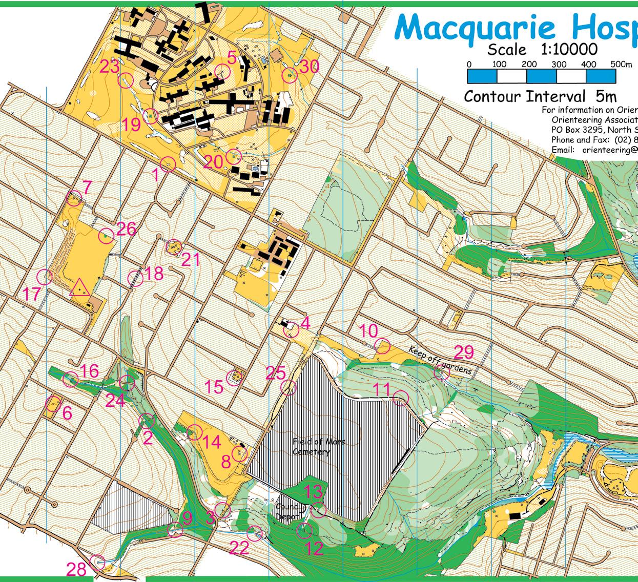
There are many challenges in organising an Orienteering event, but this article will focus only on the course setting for an Urban Score Course. The article uses the Macquarie Hospital event held on 29th October 2008 as an example
The first and most important task is to decide what the event aims to achieve. For an Urban Score Course I see the following challenges:
F Easy navigation - about Green orienteering level. F Route Planning - for the experienced orienteers the event
should:
a. Challenge their ability to plan an effective route; b. Challenge their ability to run the course at speed; c. Have a winning time for all controls of about 45 minutes. F Suitable for inexperienced orienteers by making: a. All controls easy to find; b. A variety of controls close to the start/finish; c. All controls are “in play” – there are no controls which are not worth the time taken to get them. F Event safety - the main issue for this event is the busy roads. F And most importantly - the event should be fun! Now the aims of the event have been determined, all course setting decisions should be made to achieve these aims.
Easy Navigation – Green Level
Green level courses can have controls on linear features (tracks, fences, watercourses) or obvious point features (man made objects, rocks) close to strong linear features. All controls should be able to be found by following linear features, but cross‑country “shortcuts” between linear features is to be encouraged. This is harder than a Blue level course where a checkpoint must be placed on each change in direction (such as track junctions), and easier than Orange level courses where legs can be set which require compulsory cross country navigation. On most Urban maps it is not possible to set courses much harder than Green level as the terrain is usually streets and urban parklands. Where the possibility of harder controls exists the course setter must resist it – it would not be appropriate for an event where beginners will be competing. Therefore in the example event all controls were placed on features suitable for Green level orienteering.
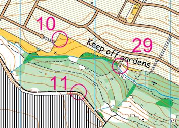
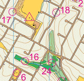
Figure 1 - Checkpoints on linear features or obvious point features
An example is the setting shown in Figure 1. Control #10 is set on an obvious point feature in a parkland, control #11 on a track and control #29 on a point feature which is obvious from the parkland next to it. All these controls can be reached via tracks and parklands, but cross country legs from #10 to #11 or #29 to #11 will encourage experienced orienteers to try a cross country leg as a short cut. During course setting I walked both these potential short cuts to check the terrain was correctly mapped and the scrub levels acceptable.
Route Planning
A key factor of an Urban Score event is challenging route planning. In a good course there will not be an obvious way to connect the controls together, with the result being that in the event competitors do a wide variety of routes. I received several comments that this
event was well set so I assume people found planning a route challenging! However I must admit I set the controls by putting a control in every corner of every park. After doing this I saw that there was a broad spread of controls and no obvious way to connect them – easy!
Running Course at Speed
This, along with running speed, will be the factor which decides the top couple of competitors in each class.
Figure 2 - Macquarie Hospital is easy navigation but the changes of direction are tricky at speed.
An example of my attempt to achieve this objective is shown in Figure 2. Even though each individual control here is simple and would present little challenge to an experienced orienteer, what I tried to do is make it so that as the competitor leaves one control the direction to head for the next control is not obvious. For instance the leg from control #20 to #1 on the most direct route involves going in a direction with no distinct feature to guide you in. The road is crossed at an acute angle which gives little assistance to your position. However this leg is considerably simplified by the road to the SW of #1 which is a strong catching feature to guide people into this control – the hospital grounds was not big enough to spread the controls out more!


Course Length
From measuring what I thought was the optimum route in previous Urban events over the years I use 9.5km as a typical course length for the winner in 45 minutes on a fast course (ie mainly roads). If the course is slow (ie lots of slow bush tracks) the distance is about 8.5km. For the course I set here I worked out what I thought was the best route and measured it to be 9.8km. As this is a little longer than my normal length I expected the winner to finish in about 46 minutes. As it turned out, Richard Mountstephens won the event by getting all controls in 45 minutes exactly, so the winner was slightly faster than I had expected. Richard’s run is particularly noteworthy as the event was held after a wet and rainy day so all the tracks were wet, slippery and slow.
All Controls Easy to Find
This was achieved during the field check of the control sites to make sure all sites were clear and described with no ambiguity. An example was control #23. Originally it was placed on a distinct vegetation boundary (marked in blue in Figure 3). While the site looks fine on the map, when you are actually there the area has light tree cover throughout and the transition from open tree covered ground in white to open grassed area in yellow was definitely not distinct. The control was moved to the embankment a little NE where the feature was much more distinct and therefore suitable for an event at Green orienteering level.
Original site for 23
Figure 3 - Control #23 had to be moved to a distinct feature
A second factor was the use of thick, high‑visibility tape at each control. Often the tape was more visible than the control. If you were close to the control I wanted you to see it straight away. People should not be hunting around for hidden controls.
A Variety of Controls Near the Start/Finish
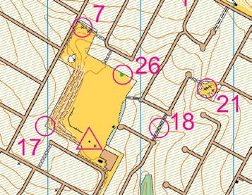
To achieve this aim I set three checkpoints in Garran Park (the Start/ Finish location) itself (#7, #17, #26), and another two close by (#18, #21), as shown in Figure 4. The hospital had another six and the small track network south of Pidding Road had three (#2, #16, #24). All of these controls should have been easily reached by even the least fit competitor. I also had a variety of controls in the Pidding Park sports oval, the misshapen layout of the hospital grounds and the bush tracks in the region south of Pidding Road. These controls were worth a significant number of points (the remainder of the course is significantly more spread out) which means even the most unfit competitor can get a few points, and tends to bunch the scores together. People feel happier when they do well and the top of the leaderboard is in sight. It is disheartening being beaten by miles by the top runners. I wanted even the most unskilled competitor to find a generous number of controls so they felt happy about their efforts rather than only finding a few and being beaten by miles.
All Controls “In Play”
When a competitor looks at the map, no matter what their orienteering skill, all controls should be “in play”. That is all controls should be worth an amount of points matching the time and effort required in getting the control from the controls immediately adjacent to it. There should be no obvious lonely controls which are clearly not worth enough points to warrant visiting. This means controls which are a longer distance apart should be worth more points than those close together. This is best demonstrated by two examples of bad course setting: 1. Don’t set a low value control which requires a huge effort to get to “just for the top runners”. All this does is make top runners who leave this control out get 590 points (out of 600) and those who do get it come back late and end up with about the same score. 2. Don’t think that controls need to be given higher scores as they get further away from the Start/Finish. If the controls are worth more as you go further away from the Start/Finish then one minute’s running a long distance from the start/finish will get you many more points than one minute’s running at the same pace near the Start/Finish. This tends to needlessly spread the scoring out as only the faster runners can get into the region of high points and the less fit people are stuck with lots of low value controls. Controls should be scored so one minute’s running anywhere on the course gets you points at the same rate. In fact I like to bias the scoring such that the scoring rate near the Start/Finish is faster than at the edge of the course, as this tends to:
• bunch the scoring up as the inexperienced orienteers can also get into the area of high scoring rate; • encourage the top orienteers to spend some time near the Start/Finish. This means new orienteers are more likely to see the top orienteers on the course during the event and see their skill in action – this gives them something to aspire to.
Event Safety
Quarry Road and Pidding Road are the two busiest roads on this map. Twin Road and Badajoz Road are also a bit busy. As course setter you have to trust the competitors to be sensible crossing roads, but the course setter can help safety by: 1. Minimising busy road crossings. A busy road should be crossed no more than twice – once to get out there and once to get back. You should not encourage people to cross busy roads any more than this by setting controls which require zig‑zagging across a busy road multiple times. Thus the course was set so the main busy roads would be crossed once to get into a region of several controls and crossed once to return. 2. If crossing points like underpasses or pedestrian bridges exist then place a control in the middle of it so competitors will use it rather than crossing the road. Even if the control is a short distance from the safe crossing point some sneaky competitor may think they can save a few seconds by taking their chances on the road. The example event had no underpasses or bridges on the map so this could not be utilised. 3. It is safer to cross a busy road while travelling along it rather than trying to cross it directly. If you are running along a road on the footpath and want to cross it you can keep running until a break in the traffic appears, then cross. This means you are unlikely to lose much time on the road crossing as you can keep running until a break in the traffic appears. If you are crossing straight across a busy road, then if the road is busy the only thing you can do is to stop and wait. As a competitor this is frustrating. It is time lost and can be a safety problem as in the heat of competition somebody may be tempted to take a risky crossing. Take for example connecting control #21 to #15 or #4, as shown in Figure 5. This leg would require crossing busy Badajoz Road, circled in blue. To maximise safety on this leg I made it so you would have to run along Badajoz Road for at least a block before turning down a side street. This means you have a fair bit of time to cross the road without having to stop and lose time – and there should be no reason to take a dangerously small gap in the traffic.
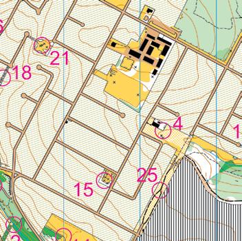
Figure 5 - Checkpoints set to make road crossing safer. Badajoz Road, a busy road, is highlighted in blue.
Make the Event Fun!
To achieve this aim I thought about what I enjoy in an Urban Score Course and tried to incorporate these concepts into the course. Things like: 1. I enjoy exploring obscure back‑alleys, the far corners of parks few people visit, and local highlights (like waterfalls, lookouts, interesting monuments). To achieve this I put controls in lots of parks, alleys and back lanes of the map. Not one boring control was placed “just” on a road. Three controls were placed on interesting local spots (see Figure 6): Control #22 was on a great little waterfall which was running strongly because it rained during the day before the event; control #24 was placed on a fascinating old bridge with sandstone buttresses; and control #17 was placed high above Gannan Park, overlooking some unusual terracing. As you could see control #17 from the Start/Finish it was great fun to see people going for this control by all sorts of different approaches.
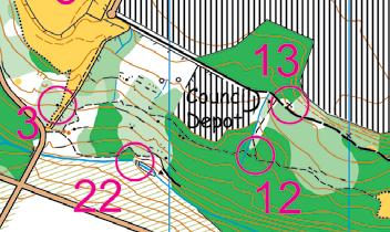
Figure 6 – Above: Control #22 was on a waterfall. Right: Controls #17 and #24 on interesting features
2. I enjoy going to new places, and seeing things like parks and hospitals from the unusual perspective of an orienteer. Macquarie Hospital has been in many events previously but it has always been a long way away from the Start/Finish so only the fast people could get there. This event gave me the opportunity to let everybody have a play in the hospital. Additionally, in the Field of Mars parklands the area around controls #12, #13 and #22 have not been fully used in previous events (see Figure 6), and extension of the map south of Quarry Road and Pidding Road meant I had a new area with a few new tracks and parks. 3. I don’t enjoy climbing hills any more than is necessary. The area used for this event is undulating but not as hilly as some Urban maps. No controls were set on top of hills or the bottom of valleys where the only option is just to climb back up again. Control #17 was probably the closest one to being a “pointless climb” but it was such a great spot I had to use it. 4. I don’t enjoy unavoidable doglegs (controls where the only option is to backtrack the way you came in when exiting the control). Every control had at least two approaches. Control #22 (see Figure 6) had only one track leading to it so was a dogleg if you did not leave the tracks, but the option of going cross country to the north was possible and several competitors did that during the event. That is a summary of a few of the things I considered when setting this Urban Score Course event. For those who have not yet done the hard but fun work of course setting – hopefully it makes you think about what a course setter is trying to achieve and appreciate the effort that goes on behind the scenes.