6 minute read
CLIMATE CHANGE


Extreme weather
brings floods and fire
Floods in northern Queensland, cyclones tracking down the coast, record high temperatures in South Australia and Victoria – and bush fires. Last summer brought all these extremes to us and Orienteering is still counting its losses. Most tragic being the loss of lives in Victoria. Orienteering terrain was also lost. In some areas it will be many years before the forests are suitable for competitions again. Falling trees will be a major safety problem for some time. Eucalypt forests will recover fairly quickly though seedling wattles and other vegetation may grow thick in places, radically changing the vegetation appearance on maps. Pine forests which have been destroyed will be harvested and replanted making them unusable for Orienteering for many years. Orienteering forest terrains destroyed or severely affected include:
Neil Barr (Bendigo Orienteers) gives some graphic descriptions of the Bendigo fire:
Belltopper Hill (TK) Darlimurla (MTBO BK) Devonshire Reef (BG) Gembrook (DROC) Lake Mountain (BK) Lake Wombat (BK) Mortimer Park (BK) Mount Robertson (YV) New Saint Mungo (BG) Watsons Creek (DROC) Wellington Chase (DROC) Williams Creek (BK) Stanley (MTBO AW) Strath Creek (YV) Two Kangaroo Creeks (TK)
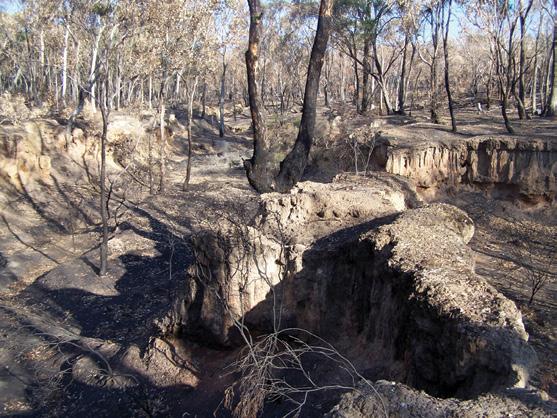
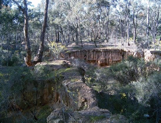
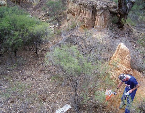
THE Daylesford fire burned the southern part of the Lake Wombat map, and after my last experience in that terrain, I was not at all surprised to see that the infra-red imagery showed an extremely hot burn. The Bendigo fire burnt most of the forest terrain on the New Saint Mungo map. That map will not be safe for a few years until the many partly burnt trees have fallen. New Saint Mungo was the map used for the 2006 Easter Prologue. Those who competed in the event will remember the terrain as a mix of forest, mining land and suburbia. The fire was started less than 500 metres to the west of the map. With gale force winds and 46ºC temperatures, the fire raced through a paddock, into the mapped area, and emerged on the other side where it ran as a narrow tongue of fire deep into the suburbs of California Gully and Ironbark. Over fifty houses were destroyed. There were many amazing stories of loss and survival. One disabled homeowner refused to leave and died trying to defend his home. A colleague of mine arrived home in time to use earth-moving equipment to smash a firebreak through the middle of his house and save the front four rooms. The fire highlights a dilemma for the town of Bendigo. The city likes to describe itself as the town within a forest. The forest surrounding the town was protected to provide a reliable source of timber for the mining industry. The mining industry has moved on from wooden props, but the forest legacy for the orienteer is a suite of eight bush maps on the edge of the town. But there lies within the town another interesting legacy. The main reef system runs from the northwest (starting in the Fiddlers Green map) and bisects the town in a line running to the south east (ending in the Diamond Hill map). Along this line lie a number of areas that were long ago reserved for future mining use. They are unlikely to be developed for housing because of a combination of arsenic-laden soil and numerous mineshafts capped some 80 years ago. (There is one house in Bendigo which has been built over a mineshaft. Apparently the lounge room floor is transparent and the residents can look down a mineshaft illuminated by fairy lights.) One of these reserves is maintained as a formal park. Victoria Hill Historic Site is a great place to explore. It was burnt on the 7th of February. Some reserves are maintained as semi-managed parklands and some are left as historic wastelands. The New Saint Mungo map lies along this line of reefs. Within these reserved areas are some fascinating venues for Sprint maps based on mining terrain, and the Bendigo Club has been slowly mapping them. Work was underway on one area burnt in the fire. The reserves are now seen as a serious problem for Bendigo. Some harbour thick vegetation, and their orientation is perfect for conducting fires into the heart of Bendigo. This is what happened on the 7th of February. When the cool change arrived, the fire front was little more than a kilometre from the centre of the town. The fire may have been much worse but for some judicious fire reduction burning conducted in the area in the previous autumn. The big question for the town now is how to manage these reserves to minimise fire risk yet maintain their historic value.
Australian climate change
Data from the Bureau of Meteorology shows: • More rain in Australia’s northwest since 1950, but less in the south and east; • Increase in the intensity of Australian droughts; • Victorian rainfall has declined by 10mm per decade in the west, and more than 20mm per decade in central and eastern areas; • Rise in sea level of about 70 mm since 1950; • Impacts include more droughts, fires, heat waves and storms, and fewer frosts, less water resources and snow.
Australians connecting Australia on climate change

at a juvenile detention centre, while over the border a woman discusses sustainability. Across country, the YMCA is being educated on sustainable business practice, while a secondary school teacher is talking to her geography class about global warming. And in Sydney’s west, a woman is standing in a church speaking to a group of mainly middle-aged Italian women about climate change. The Connectors Project, run by the Australian Conservation Foundation, was borne from the success of the Climate Project - Australia. In 2007 Al Gore, working in conjunction with ACF, visited Australia to personally train a group of Australians to deliver his presentation, made famous by the film An Inconvenient Truth. ACF was overwhelmed with applications and it was clear that around Australia people were ready and able to take a leadership role in the fight against climate change. In rural Victoria, Pat Naughtin, a Climate Project Connector, is presenting to a Rotary club filled with farmers. Pat has presented to more than 1,200 Rotary and Probus Club members from western Victoria to the Queensland border. Pat is from a family of farmers who have been active in Australian agricultural communities since the 1810s. One of Pat’s goals as a Climate Project Connector is to inform farmers, a sometimes conservative section of the community, and to get them to question their attitudes toward farming practices and climate change. “Farmers have an appreciation for the interconnectedness of ecology and farming,” he says. “They know that you cannot change one part of a living system without changing everything else. However, there are still some farmers who hold the belief that it is OK to exploit the earth for everything it offers.” Pat is made of tough stuff, so tough in fact that he happily conducted his climate change presentation at a Rotary club in northern NSW to a group of farmers involved in one of the most environmentally destructive farming practices, cotton growing. He had a receptive audience who asked well-informed questions, but he says jokingly, “I left in one piece largely because the farmers consider me to be one of them.” “Farmers, like everyone, are looking for ways that will give them an edge. I spoke in terms of my own farming experiences, and they could really relate to that; I suppose I talk like a bushy.” And that, says Pat, is the key to the Connectors Project success. When people go out into their own communities and talk about what they are doing and what their communities can do, people listen, and more importantly, they act. Website: www.acfonline.org.au/connectors
New Saint Mungo 1 – after
New Saint Mungo 2 – before New Saint Mungo 2 – after