6 minute read
Navigating the Outdoors – Part of the Adventure
By Bill Anderson, Ottawa Orienteering Club
A FEW WEEKS AGO I set out from Ottawa towards Quebec City for a ski holiday. I had been there a few times, the last time about 10 years ago. I couldn’t find my provincial road map but I didn’t think there would be a problem. I would simply follow the road signs and then use a friend’s phone instructions to get to her place in the old city.
Advertisement
Well, we missed the first exit to Quebec City after the Champlain Bridge, and then almost missed route 30—which was still under construction the last time I passed that way. A couple of hours later we crossed the new bridge at Quebec City but wandered into the wrong part of town by following our friend’s (who does not drive) general instructions. Fortunately, we found a tourist kiosk that supplied information, and maps that we should have studied before we started out.
You would think I would know better. I spend a lot of time in the outdoors making and/or updating topographical maps for orienteering and cross-country skiing. I also love to sail and wouldn’t think of heading out without the most detailed chart I could find for my sailing plan. Buy the Map!
If you are a tourist or an adventurer you will expand your awareness and improve your feeling of security if you always know where you are and how to proceed to your next objective. So buy or borrow a current and detailed map of the area you plan to visit. Those statements may sound trite, but I frequently meet hikers or skiers in the middle of Gatineau Park who: a) Don’t have a map (or compass) and don’t have a clue where they are; b) Have a 25 year old map and can’t figure out the current trail system; or c) Have a map, but can’t relate the scale to their objective and/or don’t understand the mapping symbols.
Detailed maps for specific park areas can be purchased at most outdoor outfitters in the Ottawa area or at the Visitor Centres at the park gates. For a complete selection of adventure and tourist maps, I recommend visiting a store like A World of Maps on Wellington Street. Understand the Map
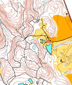
Maps for outdoor adventures vary from versions that provide only sketches of the local trail network to much more useful topographic (topo) maps that provide contours, water features, and man-made objects - including the trails. These better maps also include a grid to provide navigational reference points like longitude and latitude. If you plan on any off-trail adventures you simply must have a recent topo map with you, and the knowledge to use it effectively.
The level of detail on these maps can sometimes be overwhelming to a novice—particularly the contours—there is a learning curve that must be followed to become comfortable with using these maps. You could take a comprehensive course in land navigation, like the one offered at Algonquin College, but for most weekend adventurers that’s not necessary. Instead, you could study a book, like the classic Be Expert with Map and Compass by Kjellstrom, or you could contact a local orienteering club to see when it offer clinics on using a map and compass.
Beyond the basic instruction, the key to confident navigation
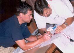
Photo by Dave Brown

is to practice “on the ground.” For example, you could head out to Gatineau Park with your topo map and follow a planned route of your choice along (or just off) some of the popular trails. Then as you hike, take the time to “check-off” on the map every landmark you pass. Take a note of the lakes, streams, steep hills and valleys, trail junctions—anything and everything that would help you locate your position on the map. After a while you will find that the major skill for effective navigation is simply concentration. Make a Plan—Map Preparation
Every outdoor adventure should include a navigational plan. The topo map of the area should be marked with the planned route, including the planned stopover points. After setting out, everyone in the group should be kept up to date on the current location so that, in case of an emergency, anyone can assist in the navigation towards safety or recovery points.
There are several basic map elements that should be understood before the plan is completed. These include the scale, the magnetic variation, and any special symbols used by the distributor of the map. Of course, the map should always be encased in a waterproof bag and stored in a handy location. Bring a compass—but know its limitations.
When navigation skills are taught in schools and clubs there is often too much emphasis placed on the use of the compass and not enough on map reading and preparation. Carrying a compass is important, but it basically only tells you the direction of magnetic north. It doesn’t tell you where you are, where you have been, or where you plan to go. Compasses that come with a protractor and sighting plate enable you to take accurate straight-line bearings. That’s great if you are, for example, on a lake and you can head directly towards a recognized point of land. But you had better check the chart first to see where the reefs are! Similarly, a compass bearing on land is handy but it only acts as a compliment to your hiking plan based on the map details—like the twists and turns of the trails. Will a GPS unit help? Maybe.
The new Global Positioning System (GPS) units, which depend on transmissions from satellites, can tell you your position on the earth, in terms of longitude and latitude, to within five metres. That’s a big help, but you have to know how to convert that information into an actual point on a map. That is a skill you must learn before you head out on your adventure.
For $200, a basic unit has a digital compass as well as memory for storing co-ordinates (waypoints), but you still need the topographical map for navigation. Of course, for many more dollars, you can get a GPS unit with built-in maps that show you (sometimes in a sketchy sort of way) where you are. But so far, the only GPS-based maps that have any relevant detail are for city folks, truck drivers, and fishermen. Will there ever be a Gatineau Park GPS map with an adventurer’s level of detail? I’m sure it will be available some time in the future. But bring extra batteries, your old compass, and a paper topo map along as well, just in case. Get Outdoors!
Don’t let a fear of getting lost prevent you from enjoying the outdoors. Don’t let those “complicated-looking” maps or technical navigational aids hold you back either. Basic map and compass knowledge, with practice on the ground of course, will increase your level of enjoyment during any outdoor adventure.
World of Maps: www.worldofmaps.com Ottawa Orienteering Club: www.magma.ca/~ottawaoc Algonquin College: www.algonquincollege.com Be Expert with Map and Compass is available at World of Maps and many local outdoor adventure stores.


