
PATHAugust2022,Issue#107 PATH Foundation A Non-Profit Organization Dedicated to Planning and Building Greenway Trails CONNECTING COMMUNITIES ACROSS GEORGIA WITH 300 MILES OF NEWSTRAILS Eastside TrolleyTrail UnderwayStoryonpage2 Artist’s rendering of Arkwright Place and Whitefoord Avenue after trail and redevelopment are complete.


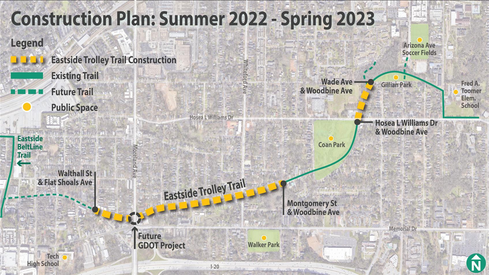
On crewsconstruction11th,JulyPATHbegan to build the next segment of the Eastside Trolley Trail.
TPATHFoundation.orghePATH team and community leaders have dreamed of a trail that would follow the old Atlanta-Decatur Trolley route through Kirkwood intersecting with what is now the BeltLine Trail. The City of Atlanta Councilperson Natalyn Archibong, the Kirkwood community, and PATH kept the project alive for the past decade.
Northbound view of construction starting at Gilliam Park.
UnderwayTrolleyEastsideTrail
The Eastside Trolley Trail segment now under construction will cost $1,987,800 to build. The City of Atlanta’s 2016 TSPLOST funding along with support from PATH’s donors are being used for completion of this segment which will be open to the public in the fall of 2023. What’s next? GREAT NEWS! In the recent passing of the City’s Infrastructure TSPLOST/Bond ballot, the next phase of the Eastside Trolley Trail was allocated funding! Thank you to everyone’s support of the trails on the ballot and for the support of Atlanta DOT and the new City Councilperson Lilliana Bakhtiari. PATH can now begin to plan for the next phase of the Eastside Trolley Trail to connect to the BeltLine and two additional spur trail connections.
2
On July 11th, PATH construction crews began to build the next segment of the Eastside Trolley Trail from the existing trail in Gilliam Park to Flat Shoals Avenue. There will be a small gap around Moreland Avenue which will be built within a Georgia Department of Transportation project.
l
PATH built the initial segment of the Trolley Trail before the 1996 Olympic Games, but with the Atlanta BeltLine in play and the changes occurring in the Kirkwood area, a more extensive trail system is needed.

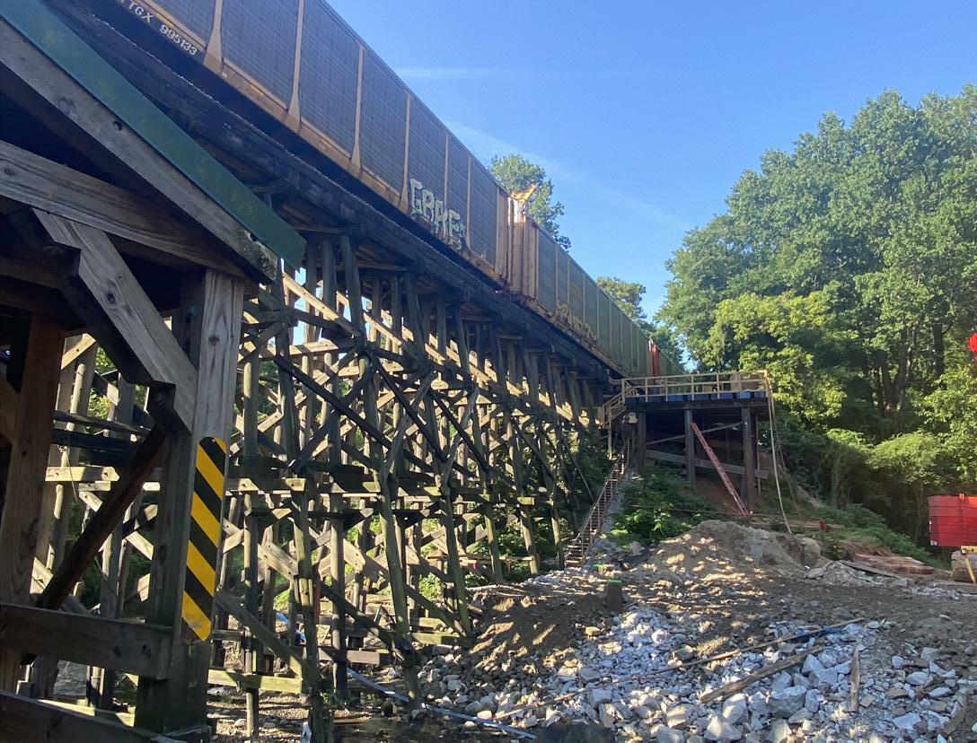
CSX has built a protective cover over the canopy we built in 2009
Last year, CSX announced plans to replace the old wooden trestle. Earlier this year work began on the trestle bridge to the west side of the existing trestle. The construction has necessitated temporary use of the open greenspace west of the trestle as a staging Trestle Re-do area and closure of the trail leading to the canopy bridge. CSX will route trains over to the new trestle once construction is completed and begin demolition of the old trestle. CSX has chosen to protect the existing canopy bridge during the replacement activity and will rebuild the trail after all trestle work is complete. The contractor plans to have all work finished by the spring of 2023. This segment of the Tanyard Park Trail will be part of the Northwest BeltLine Trail connecting the Westside and Eastside BeltLine Trails. PATH has partnered with Atlanta BeltLine, Inc. (ABI) to design and build the Northwest BeltLine Trail. The partnership’s goal has completion of the entire Northwest BeltLine Trail by 2030.l
In 2009, PATH and the City of Atlanta built the trail that begins just south of Ardmore Park and ends at Bobby Jones Golf Course. CSX Transportation partnered with us to make the trail’s connection between the parks to go under the wooden trestle as it spans Tanyard Creek. The conditions associated with the connection included ‘squeezing’ between the trestle support beams, and building a canopy over the trail to protect trail users from anything falling from the trestle, such as ballast from the track above.
AUGUST 2022 3
Temporary trestle work is evident on west side of existing trestle
CSX staging area west of existing trestle with trail removed


races,thethebefore,”ourthe“Theorg)ThebikelookingfacilitiescanleadershipwhatLaGrangeimpressive,SPLOSTtheStewardshipthroughtheRecreationalgrantsuccesscommunity.philanthropicgenerousTherateforusingfundingthroughtheTrailsProgramandrecentawardofgrantfundingtheGeorgiaOutdoorProgramhasallowedFriendsgrouptoleveragethefundinganddomoreinantimelymanner.isaperfectmodelforacitywithforwardthinkingandlocaladvocatesdowhenwalkingandbikingareapriority.Ifyou’reforafunplacetorideyourthissummer,giveLaGrangeThreadatry.(thethreadtrail.ThreadhasmadeLaGrangeplacetobeandhasbroughtcommunitytogetherasneverNataliesaid.“Itisarguablybest,mostusedamenityincity–anditisfreeforallages,andabilitiestouse.” l Pedestrians enjoying a new section of The Thread.
FPATHFoundation.orgueledbytheir common desire to enhance the quality of life and overall viability of their city, the City of LaGrange and a small group of inspired individuals engaged the PATH team to create a greenway trail master plan in 2016. The greenway trail master plan suggested building 29 miles of greenway trails to reconnect the city, entice employers and new businesses to downtown, and enhance the health and overall quality of life for the citizens and visitors to LaGrange. Over the past six years, PATH has continued its partnership with the city to design and build 11 miles of The Thread Trail System with another 2 miles currently being designed to start construction this fall.
Thread Spooling Up position for the Friends group to trail.developmentexpediteofthe Natalie Hale has been the Director of the Friends group since early 2017, working with the city staff and contractors to build out The Thread Trail System. Natalie does everything from writing grants for trail funding, advocating for the trail system, managing the design and engineering of each segment, to overseeing the construction crews in the field. From her office at city hall, she works closely with city staff and city utilities to promote and build The Thread. Her office location is a key factor in nurturing a great public/private partnership between the Friends of The Thread and the City of LaGrange. “We have enjoyed our partnership with PATH,” Natalie said. “Their experience in trail building helped guide our local team’s accomplishment.”
4
LaGrange has primarily funded their trail projects through SPLOST, grants, and a
The driving force behind The Thread is the Friends of The Thread, a 501(c)(3) advocacy group formed to encourage development and facilitate philanthropic funding opportunities. In late 2016, the Callaway Foundation funded an Executive LaGrangeDirector


TrailQuantifyingUsage
For many years PATH has been asked, “How many people are using PATH trails?” But how do we quantify the numbers in order to share them with our partners at the City of Atlanta and throughout the State of Georgia? Municipalities need to know the number of people that use trails so they can justify continuing to spend taxpayer dollars on trail projects and to know the benefit trails are providing for everyone in the city. Likewise, donors to PATH need to know that they are investing philanthropic dollars in something the public wants, uses, and are Attemptsenjoying. have been made at estimating trail usage in the past by placing volunteers at various locations around PATH trails. But the data we have collected has been unreliable. Generally speaking, there has been nothing scientific about efforts to estimate trail usage; we were busy building Atrails.2010 economic study of the Silver Comet Trail had a consulting team placing personnel at various locations along the trail for a couple of weeks. They concluded that 1.9 million people a year were populating the trail, but was this methodology the best way to get trail user counts? Who selected the stations? How many users failed to pass their stations? Recently, PATH purchased trail counters which make it possible to access trail usage on a daily basis, even distinguishing between pedestrians and cyclists. The PATH team installed EcoVisio counters (pictured above) on the Chastain Park Trail, the Westside BeltLine Connector, and the Northwest BeltLine Connector trail near Bobby Jones Golf Course. The counters will be moved to other trails annually or as data is needed. The counters cost about $4K each and have a monthly service fee for ease of auto-transmitting the data. Currently, the Chastain Park Trail has highest number of daily trail users of the three trails being monitored. The majority of trail users along the Chastain Park Trail and the Bobby Jones Trails are pedestrians, whereas the Westside BeltLine Connector has more cyclists than pedestrians. A graph showing the results of our effort to quantify trail usage is shown below. PATH will compile data from the counters and post it from time to time on the PATH website. l Eco-Visio counter at Chastain Park on Lake Forrest Drive


6 PATHFoundation.org Welcome New Board Members Northside UnderpassDriveDedication Atlanta Mayor Andre Dickens continued to show support for trails by helping the PATH team and neighborhood leaders dedicate the trail underpass at Peachtree Creek and Northside Drive on May 21, 2022. Download Our New App! • Interactive trail maps • News + Announcements • Available at the App Store & Google Play Jaime Hockin VP of Government and Legislative Affairs Georgia Power Company Tree McGlown Chief Revenue Officer (Sideqik acquired by Engine Media) Lyle Ross Director of Institutional Client BlackRockBusiness Lauren Wilson Chief of Staff Chime Solutions We are pleased to welcome four additions to the PATH Board of Directors. They each bring experience and enthusiasm to the PATH trail building team.


I had just brokered a deal with the Cumberland CID to extend the Silver Comet Trail from Mavell Road to South Cobb Drive at the East-West Connector when Tom Moreland leaned over to whisper, “It’s nice to have your own money, isn’t it?” The deal I had just made involved PATH committing $300,000 on the fly, to a million-dollar project. That was the first time I fully realized the value of philanthropy. So many crucial trail projects would hinge on a ‘back-room deal’ facilitated by me ‘having my own money.’ Of course, it wasn’t really “my own money.” Thanks to Jim Kennedy and the James M. Cox Foundation, it was usually their money that let me act like an entrepreneur to get things done. That partnership has made all the Whendifference.theGeorgia Department of Transportation (GDOT) announced plans to reconfigure the Georgia interchange,400/I-285GDOTwas aware of our desire to extend PATH400 north, through the interchange. Since GDOT’s charter prohibits them from building trails, we were asked if we could fund the trail work if they provided the Iright-of-way.steppedout of the meeting to call the Cox Foundation to make certain they would support my commitment to pay for the edwin@pathfoundation.org
AUGUST 2022 7 ED’S CORNER
It’s Nice To Have Your Own Money connection. I was able to return to the GDOT meeting and tell GDOT that PATH would pay for the trail. The PATH400 trail segment between Johnson Ferry Road and Peachtree Dunwoody Road will open next summer.
Clairmont Place Condominiums wanted a gazebo on the lake and an improved walking trail around their lake before they would sell us the land and we needed to connect Emory University to the surrounding neighborhoods. Philanthropy enabled us to make the improvements they wanted and connect the trail to Emory. Again, if DeKalb County had to use public funds to make the desired improvements the trail development would have been delayed or never built at all. We had to assemble the rightof-way for the Silver Comet Trail between Rockmart and Cedartown. The railroad is still active, so I took on the role of right-of-way man. We cobbled together federal, state, and local funds to construct the trail but the red tape associated with acquiring right-of-way with public funds would have been a nightmare. It was a time for me to have “my own money” as I went door to door making deals. I worked hand-in-hand with my buddy, Joe Anderson, an attorney from Cedartown, to acquire all but one skinny parcel sandwiched between the railroad and an occupied house. It was the only gap left on the ten-mile trail corridor. I offered the going rate for the strip of land but the owner said no. He implied that if I’d install a new window air conditioning unit at his grandma’s house in Cedartown, we had a deal. Granny got a new AC unit and the right-of-way was complete. I paid for the parcel and the window unit with “my own Assemblingmoney.”millions from public sources will eventually get things built but philanthropic dollars allowed PATH to have their own money when commitments needed to be made. If it weren’t for the generous philanthropic community in Atlanta, the Silver Comet Trail, PATH400, and most trails we have built, wouldn’t be Tomhere.Moreland was right. We had to have our “own money” to make things happen. l

8 PATHFoundation.org PATH Foundation Board of Directors Charlie Shufeldt, Chairman Alexander C. Taylor, Vice Chairman Jennifer Dorian, Secretary Harry L. Anderson, Treasurer William C. Fowler B. Harvey Hill, Jr. Jaime StephenE.ScottSarahJamesCiannatHockinHowettC.KennedyK.KennedyKitchensCodyLaird,Jr.Lanier PATH Foundation P.O. Box 14327 Atlanta, GA 30324 U.S.First-ClassPresortedMailPostagePaidAtlanta,GAPermitNo.8163 Follow us on Facebook and Instagram and visit our website at pathfoundation.org. Facebook Instagram Tree McGlown Lyle JohnRossW.Somerhalder II C. Austin Stephens Richard Tyler Lauren Wilson Sam Friedman, Emeritus Chairman W. Douglas Ellis, Jr., Emeritus Carol Muldawer, Emeritus Greta deMayo, Executive Director Ed McBrayer, Executive Advisor