―
Transit Master Planning

Transit Master Planning


Introduction ― 4 Selected Projects ― 10
― Transit Master Planning
Well-planned, designed and integrated transportation solutions have the power to change the trajectory of a community. They create vibrant, walkable neighborhoods, limit urban sprawl, strengthen the social fabric, promote a healthier environment, and foster a resilient, interconnected economy.


Transit-Supported Communities
Urban population growth is increasing pressure on the social, environmental and economic resources in our cities. With over one quarter of the land mass of any municipality dedicated to transit infrastructure, the mobility of people and goods must be a foundational consideration of urban planning and city design strategy at every scale.
At the regional and city scale, we coordinate land use planning and urban design with robust mobility and accessibility options to maximize a projects’ potential for positive change. At the human scale, we understand how the character and texture of the transit experience influence the quality of daily life. From ennobling the journey from first-mile to last-mile, everything we do revolves around the integration of great access and mobility options that connect and benefit people, places and opportunity.
1. Exchange amenity hub.
2. Space for shared mobility.
3. Dynamic signage and wayfinding.
4. High capacity corridors.

Among the design typologies explored in the report, a stand-alone transit station is transformed into a physical and digital multi-modal hub, adding value through the expansion of enhanced mobility options on site and connectivity to the city.
At a moment when North American transit infrastructure is in serious need of upgrade and expansion, mobility disruptions like self-driving cars appear to offer near-term solutions that promise equitable mobility for all. The truth is that these disruptions offer as much potential to exacerbate current mobility issues like sprawl and congestion as they do to help fix them. Through our ongoing investment in research, we’ve published a new report proposing a people-first approach to integrate emerging transportation technologies into the design of cities that helps address this issue.


The report, Designing for Future Mobility: Developing a Framework for the Livable Future City, explores both the positive and negative potential impacts of “mobility disruptor” technologies that are underway in cities across North America, including self-driving cars, vehicle and ride share services, and electric vehicles and concludes that by shifting our focus to how we move people rather than vehicles, we are able to leverage and integrate these mobility disruptors with existing systems to create cities that are safer, healthier, happier, and more sustainable places to live.

Istanbul, Turkey
Client: Istanbul Grand Airport
Size: 1052 Hectares (2600 acres)
Completion Date: 2017
The Airport City Istanbul advances the aerotropolis model by creating a real, connected urban district that supports aviation but becomes a great place.
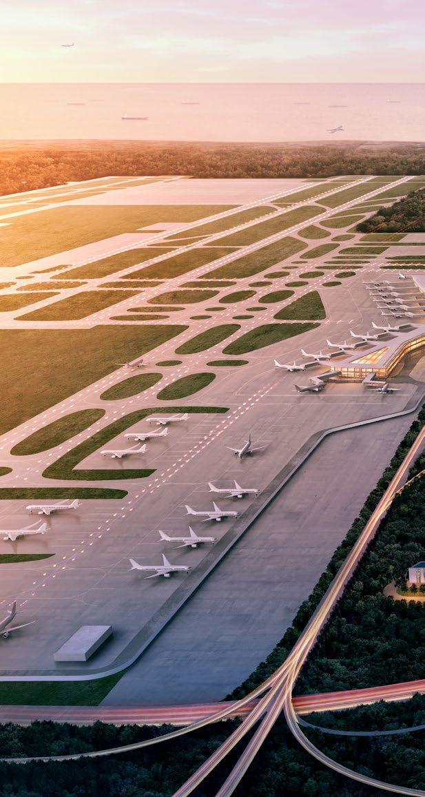
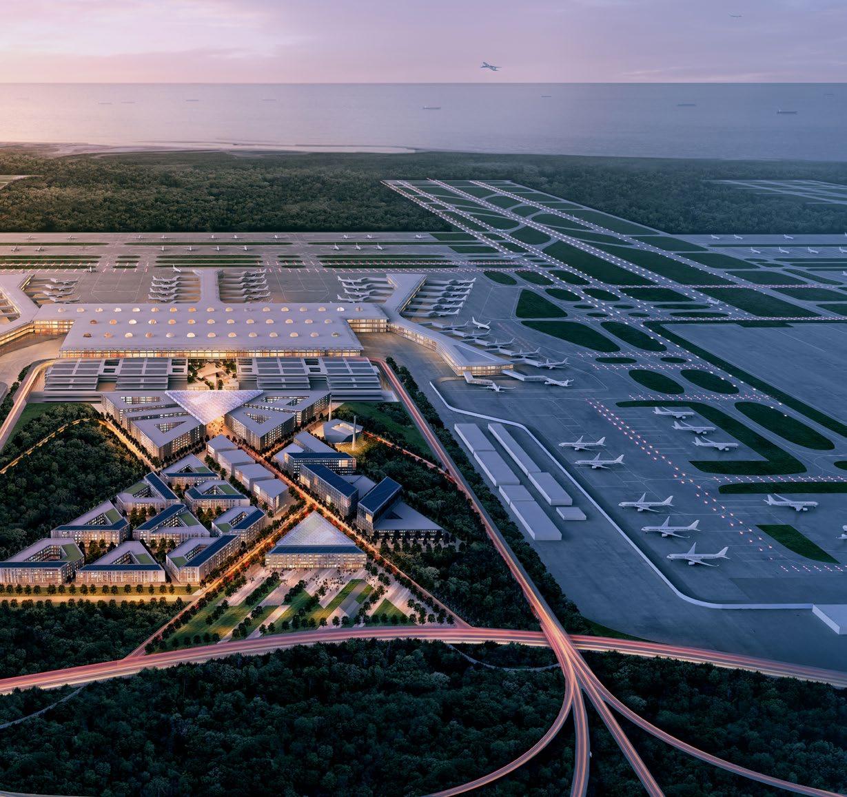
The Istanbul New Airport is planned and designed to be the busiest in the world, surpassing 90 million passengers in Terminal 1 alone. As Istanbul continues grow and globalize and Turkey plays greater role on the international stage, Airport City Istanbul will be the country’s porthole to the world, with the potential to become an economic and cultural destination in its own right.


Extending the airport environment while providing relief from the typical harsh and generic airport experience, the plan provides a convergence of mobility options and amenities at a civic scale.


― WHAT MAKES IT COOL Perkins and Will delivered the masterplan to IGA in a record-setting four months’ time.
Atlanta, Georgia
Client: Atlanta Beltline Inc.
Size: 22 linear miles (35 kilometers), 6000+ acres (2428+ hectares)
Awards:
Honor Award, Tri-State ASLA, 2014 Award of Excellence, Georgia ASLA, 2014
Overall Excellence in Smart Growth Award, U.S. Environmental Protection Agency (EPA), 2014
Adaptive Use Award, Atlanta Urban Design Commission (AUDC), 2013
Built on a loop of reclaimed railroad tracks, the Atlanta BeltLine is a 22-mile multimodal corridor consisting of public transit, a linear greenway, and multi-use trails.


Design Layers:
1. Landscape, edges, trail integration, site furnishings
2. Access, connectivity, adjacencies, interface
3. Transit alignment, station location, guideway preservation
4. Biodiversity, arboretum, public art, signage, interpretation
5. Utilities, stormwater, existing conditions, historic features
6. Economic strategies, operations, new support infrastructure


― WHAT MAKES IT COOL
This ground breaking public infrastructure reconnects 45 historic neighborhoods around the city’s urban core, catalyzing economic development as it circles the city.

The Atlanta BeltLine all started with a master’s thesis written in 1999 by then-Georgia Tech architecture and city planning student Ryan Gravel.
The design reinforces continuity and identity for the entire project by establishing a family of infrastructure elements, including bridges, walls, and railings, as well as strategies to incorporate public art and signage in this new multi-modal corridor.
San Jose, California
Client: Santa Clara Valley Transportation Authority / Bay Area Rapid Transit (BART)
Size: 6 mile (9.6 kilometer) corridor
Completion Date: Ongoing

Optimizing corridor and TOD areas based on opportunity modeling.
Assessing specific local areas of TOD development


― WHAT IT IS
The plan extends BART service deep into Santa Clara County. Parametric modelling at the urban scale supported design of a series of equitable, mixed-use, and mobilityfocused neighborhoods.
Sacramento, California
Client: City of Sacramento
Size: 33 acres (13.4 hectares)
Completion Date: 2018

― WHAT IT IS
Advances the potential of the existing station as a center of investment for the region as a wave of new jobs and people arrive in the surrounding neighborhood.

Through the introduction of a new high speed rail station, the master plan consolidates multi-modal connections, capitalizes on land value through high-intensity, mixed-use development, and connects Old Sacramento, Downtown Sacramento and the emerging Railyards District.


Upon opening in 1926, the Southern Pacific Railroad promoted the Sacramento Valley Station as a representation of the railroad’s importance in linking Sacramento to the prosperous agricultural region of Northern California.

Railyards Development Beyond at Waterfront


Dallas, Texas
Client: Texas Central Partners
Size: 880 acres (356 hectares)
Completion Date: 2019
― WHAT IT IS
A master plan that sets the stage for transformational development as the nation’s first truly high speed rail station lands on an 880 acre site in the City of Dallas.


― WHAT MAKES IT COOL
The Texas Bullet project supports the transit-oriented-development potential of an additional 29,000 jobs and 50,000 people within a half-mile radius of the new station.


Measuring the significant potential of the new high speed rail oriented development on people and jobs.

Los Angeles, California
Completion Date: 2018
A collaboration between Perkins and Will, Nelson Nygaard, and Lyft questioned how an existing city street, currently lacking meaningful places for people and overloaded with car traffic, could be redesigned to more efficiently move people and improve the public realm.

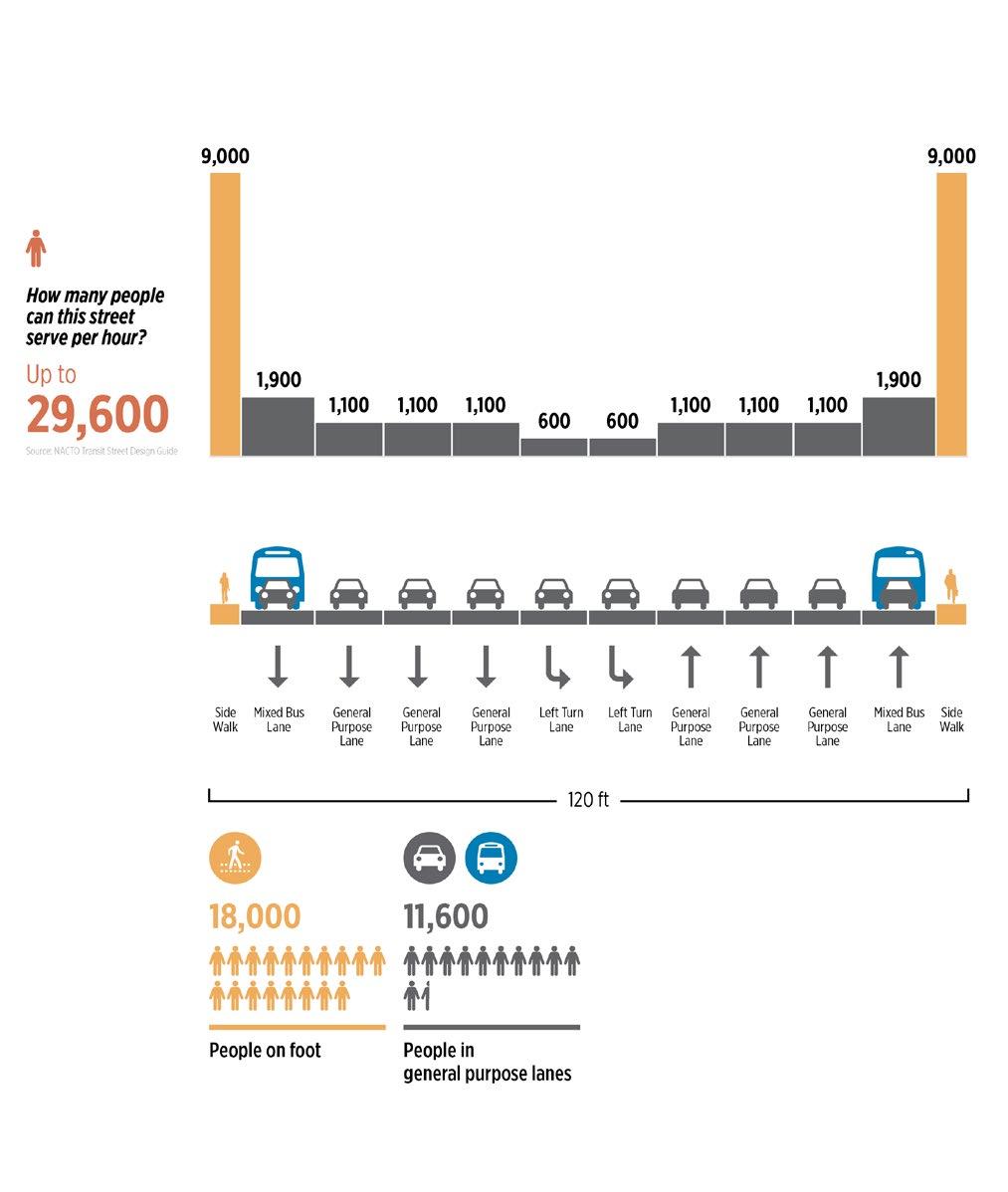
The concept re-imagined Wilshire Boulevard from 10 lanes of congested traffic into a multimodal space that moved greater amounts of people with wider sidewalks, upgraded street furniture, and dedicated lanes for bikes, buses, and shared self-driving cars.
Since 1935, we’ve believed that design has the power to make the world a better, more beautiful place.
Since 1935, we’ve believed that design has the power to make the world a better, more beautiful place. That’s why clients and communities on nearly every continent partner with us to design healthy, happy places in which to live, learn, work, play, and heal. We’re passionate about humancentered design, and committed to creating a positive impact in people’s lives through sustainability, resilience, well-being, diversity, inclusion, and research. In fact, Fast Company named us one of the World’s Most Innovative Companies in Architecture. Our global team of 2,700 creatives and critical thinkers provides integrated services in architecture, interior design, landscape architecture, and more. Our partners include Danish architects Schmidt Hammer Lassen; retail strategy and design consultancy Portland; sustainable transportation planning consultancy Nelson\Nygaard; and luxury hospitality design firm PierreYves Rochon (PYR).
For more information, contact: transportation@perkinswill.com