

About ME
An enthusiastic individual practising architecture and urban design, hopefully looking forward for learning opportunities to extend my knowledge in professional domain, motivated to work towards the good of fellow beings.
Poornima Badiger

Architect
| Urban Designerpoornimapb04@gmail.com
Education
2017-2019
M.Arch (Urban Design and Development)
Manipal Academy of Higher Education, Manipal, India.
GPA: 7.71
Thesis: Urbanity in historic place
2012-2017
Experience
05/2018 - 06/2017
B.Arch
B.V.Bhoomaraddi College of Engineering and Technology, Hubballi, India.
GPA: 7.96
Thesis: Urban Ecology Centre Urban Design Intern
Hubballi Dharwad Urban Development Authority, Hubballi, India.
01/2017 - 05/2017
Architecture Intern
2PKM Architects, Mysuru, India.
Architecture Intern
06/2016 - 12/2016
Taliesyn Design, Bengaluru, India.
Hard skills
AutoCAD
3ds Max

Adobe Illustrator
Adobe Photoshop

Certificates
ICHTR 2018 (10/2018)
Revit Architecture

Sketchup
Adobe InDesign


Lumion

Oral presentation paper titled -How is governance model a key for flood risk management? Interdisciplinary Conference on Healthcare & Technical Research (ICHTR 2018) held at MAHE, Manipal
Autodesk Revit Architecture (120 hrs)


3DS Max (80 hrs)
Interests
Curriculum
Contemporary Architecture
Landscape design
Urban Conservation
Transportation planning
Sustainable urbanism
Non-Curriculum
Reading
Movies
Cooking
Playing Guitar
Travelling
Listening to music
Contents
B.Architecture(2012-2017)
Automobile showroom
3 star Hotel design
Spiritual Centre
Thesis
Urban Ecology Centre
Urban Design Studio
Competition (2018)
HHAC 2018
Children’s Hospital and Research Center
M.Architecture(Urban Design & Developement) (2017-2019)
Urban Restructuring Through Local Actions
Urban waterfront developement
City Development Plan
Agro-based development: Agro-tourism
Thesis
Urbanity in historic place
Detailing studio
Street design in historic precinct


 South side Elevation
View
South side Elevation
View
Automobile Showroom III
The design development of Automobile showroom began with simple geometrical shapes to divide the different spaces as showroom and service centre. The circular shape Showroom with slanting roof gives the free flow circulation inside with a astound feeling.


Brief
Sem Design Development 1 2
1 Showroom
Site plan West side Elevation East side Elevation
2 Service Centre


side Elevation Top view
South
Views
3 Star Hotel & Institute of Hotel Management V Sem
Brief
Form development

The design brief was the campus planning. The project included a 3 Star Hotel and Institute of Hotel Management and also the residence for students and faculty. The proposed site was in Pune, Maharashtra. The concept of central courtyard form is more suitable for the climate of Pune, due to good air circulation throughout the building. The design development in campus planning aimed to achieve comfortable circulation and also the visual unity in form of buildings. So all the forms are developed having a central courtyard.


1. 3 Star Hotel
2. IHM
3. Faculty residence
4. Boys hostel
5. Dining hall
6. Girls hostel
Site plan Section at AA
Form development


Circulation and Axis

View
Spiritual Centre VI Sem
The site plan enhances the circulation and axis to the different spaces in the site. The main axis leads to the all faith prayer hall then to temples (gain knowledge) and then to Main Meditation hall(attain eternal salvation). This concept is based on philosophy of Dharma. The forms were developed considering the function of space and structure are developed to adopt to the local climatic conditions.


Brief
1. Administration Block
2. Cultural usic and dance class
3. Accomodation block
4. Prayer hall
5. Temple
6. Meditation hall
7. Dining hall
8. Cafeteria
9. Toilets
Site plan Section at A A 6 5 1 2 10 7 8 9 4 3
10. Open air theatre


Site Analysis N
Design Development
Brief
Thesis: Urban Ecology Centre VIII Sem

The “Urban ecology center” will offer public insight into the sustainable approach towards the urbanization. This facility conducts education programs, research pertaining urban ecology and a broad education base concerning construction and the destruction of native habitat.
As the proposed site is in Dharwad which has warm and humid climate is characterized by high temperatures accompanied by very high humidity leading to discomfort. Thus, cross ventilation is desirable and essential for all the spaces. Protection from direct solar radiation is ensured by shading. The design is developed considering the climatic conditions and making is energy efficient building by accepting north light into spaces and blocking the sun with pitched roof as shading devices.

Site plan 1 2 3 4 9 6 5
1. Parking
2. Open air theatre
3. Water body
4. Urban Ecology Centre
5. Model Residence

6. Plant Nursery
7. Student accomodation
8. Guest accomodation
9. Eco-trails
N 0 50 150m 3 7 8

Design Features

Features
Proposed Comprehensive Mobility Plan


Revitalization
Area of Interventions
Design Proposals
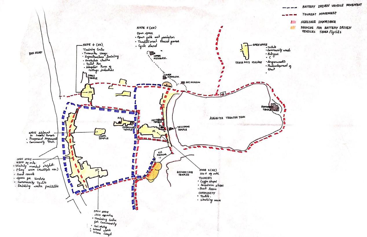
Revitalization and Heritage based inclusive development of Histric city of Badami

Urban Design Studio VII Sem
Steeped in rich history, the picturesque town of Badami is world-famous for its magnificent cave complex. It houses the oldest cave temples and structural temples in South India. Under the HRIDAY Scheme which focuses on development of civic infrastructure development projects around heritage sites, the studio began with Existing Situation Assessment & Infrastructure Gap Assessment which includes existing socio-economic, demographic, tourism and heritage profile of the city and the region. Then delineation of heritage areas around the heritage assets to establishing cultural significance.
House Typology Study
 Aerial view of Badami

Children’s Hospital & Research Centre

Manipal, India
Rectangles or squares represent stability. The concept is developed by the combination of rectangles which are arranged based on circulation and accessibility to the different spaces. Curve is a very soothing stroke. Therefore, the children’s play area is designed to have a calming effect. The multiple storeys add a feeling of stature to the form.
Site Plan


Views


Section 1
First floor Plan
Second floor Plan

 East side Elevation

Urban Restructuring Through Local Actions
Mangaluru, India
Understanding Water’s Edge
The urban fabric of Mangaluru city embraces two flourishing rivers - Netravathi and Gurupura which meets at the estuary and merge with Arabian sea. The city of Mangaluru is reclined beside the edge of interminable sea shore and surrounded by these two rivers.
Along the water’s edge, inconsistent functional districts can be observed. Most of the industrial sector nests around the water’s edge. The major industrial area Baikampady lies on the north along with New port (NMPT). The city core or the main commercial district (Bunder) of the city lies along the river’s edge which comprises the old port. By contemplating the water’s edge, it can be said that waters of Mangaluru city were mainly availed for economic activities.
The reckless approach towards the rivers is evidence of disowning the city’s own waters. The sewage outfall, solid waste, and debris dumping not only harm the environment but is also a threat for the city and the people. Even though the riverfront is spirited with inconsistent activities, there is no place to appreciate the beauty of the riverfront. The historical significance of Sultan Battery and historical landmark of Jesus Statue are not comprehended.

Issue identified
Design Proposal
Recreational area development with constructed wetland treatment. Native plantation for creating riparian basin along with the check on soil erosion.


Vegetation Building use
Roads
Land use
Gateway
Urban Waterfront Development
Vegetation:
Along with mangroves and coconut plantations, one can observe some other native plantation at the stretch of the river Gurupura.
Building use:
To the direct proximity of the river there is 40% industrial development which developed before the implementation of CRZ norms. There are few areas of heritage importance near the water’s edge also there has been developement of commercial activities.
Road:
There are very limited gateways to the riverfront, because of irregular street pattern.
Landuse:
Since 40% industrial areas are located near the bank of the river, it is highly vulnerable as there will be a constant discharge of waste into the river body. Commercial area developed in a cluster pattern increase the traffic in the area due to narrow road widths and unplanned infrastructure.
Gateways:
Due to irregular street pattern of urban form there are limited approaches to the waterfront.

Observation/ Analysis


Plan
Site
Section A
Section B
Detail 1
Detail 1
Detail 3
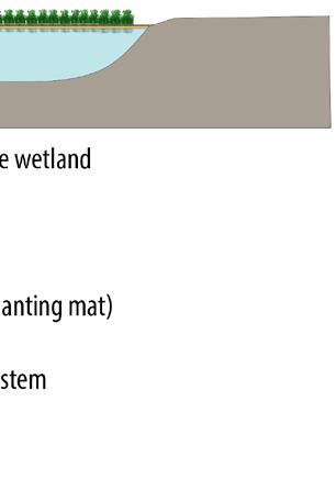
Urban Waterfront Development
Wetland Park
The area of Bangra Kulooru which used to be an agricultural land has lately becoming a residential area and settlements are turning up. The vulnerability is due to loss of biodiversity and depletion of environment i.e. the wetland destruction due to dumping of debris and sand mining as well as the industrial effluents and pollutants from storm water runoff and wastewater.
The objective is to preserve the natural setting by conserving existing wetland and improve environment quality by designing a wetland park. By considering the existing issues and analysis, wetland park has potential to reduce most of the issues around the water’s edge. The constructed wetlands have high benefits from maintaining and improving the quality of water. The floating constructed wetland near the tributaries will be an effective treatment method for the removal of impurities from the storm water and wastewater flowing into the rivers. The detention basin near the water’s edge will store the storm water thereby reducing the rate of flow of water and hold the impurities adding to the river.


Thus, proposal of wetland park will be effective in mitigating the vulnerabilities to the biodiversity and environment which also provides a recreational space for the people of Mangaluru. In many parts of the world, the waterbodies are entangled with the structure of the city and contribute to the city’s formation and its development. Waterfront in many cities is used only for industry, fishing and transportation.


Detail 3 View


City Development Plan

Kaup, India
Brief With a provoked thought of conserving Kaup culture and sustained economic growth a city development plan for 2041 was developed in the studio. The study started with analyzing the city under the lenses of Demography and history, Morphology, Transportation and connectivity within the City, Cultural Significance of the town of Kaup, Existing Infrastructural amenities (both Social and physical),Existing Landuse, Tourism Scenario and eco-sensitive zones of Kaup. The first stage of Study involved the literature review from the existing online sources. Second stage of Study Started with the base map preparation. Thirdly through Site visits and Interviews Existing situation analysis of the town in the lenses of above mentioned variables was carried out. Finally a questionnaire Survey was prepared and 300 household surveys were carried out in 9 different Villages and towns of Kaup local Planning boundry.The study ends with the important understanding to carry out the city developement plan for 2041 and Kaup design and development plan for the year 2041. Futher the focus deviated on agro-based developemnt as the Kaup has agriculture based economy. It aimed to promote sustainable and economical growth through agro based development.
Objectives
To strengthen the age old traditional agricultural practice of the coastal region with the help of modern technologies
To eliminate agricultural land conversion
To boost the localized economic value of the town through agro based development.
To provide employment opportunities for the local residents.


Site plan
Section 1
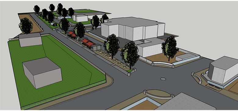
Agro-based Development


Kaup, India
Agro-Tourism
Kaup being one of the tourist spots along the coastal edge of Karnataka in between Udupi and Mangaluru has many tourist places around. Agro-tourism involves any agriculturally based operation or activity that brings visitors to a farm or ranch. Agro-tourism can range from entertaining a passerby with the scenery at horticultural and floricultural gardens, to the extent of visitors spending several days in a farm enjoying the natural setting.
Tourism is only limited to beach areas in this region. Agro-tourism has been proposed considering the following objectives.
•Raise revenue and reverse negative economic trends by bringing in visitors.
•Organic products to embrace healthy living, raise product values and encourage young generation into farming activities.
•Employment generation and community development through engaging in farming and tourism activities.
•Engaging urban visitors into village activities to experience the quality of village life.
•Increase income of local population by providing platform to sell the products.
 Market space
Section 3
Section 2
Market space
Section 3
Section 2

Abstract
Urban Design Thesis
Urbanity in Historic Place
The spatial organization of built environment create different quality in different places. The manifestation of urbanity in the city/town is experienced by the arrangement of the built structures and their functions. The experience of the urbanity is vital in a place as it provides the benefits and opportunities to utilize the spatial configuration for the individual and collective gain. The built heritage of historic Indian places has always been the cultural and economic assets of the place and fabricated urban form through the time in these place gives unique identity and meaning to the place. The structure of historic place presents the urbanity through the built form and associated activities. So, the study aims to understand and enhance the urbanity through redefining the spatial quality in the historic town Srirangapatna. The study is carried out through the literature review of different theories and concepts on urbanity and place. A conceptual framework has been derived from the literature review to study and understand the complexity of urbanity in a place. The analysis is inferred from the secondary data available and primary observation. The design interventions proposed in Srirangapatna enhance the urbanity through the built form generating wide range of activities.


Activity Mapping
Study Area
The study area selected to study is the Srirangapatna fort town as it consists of many heritage structures and is the old part of Srirangapatna town which has historical significance. The study area is approx. 2 sqkm dominant with residential land use. The only commercial area is the main road which forms the horizontal central axis to the tourist attraction Sri Ranganatha Swamy temple. The fort town also consist the taluk office and Taluk Municipal Corporation which administer the surrounding villages.
Section 1
Section 2
Section 3
Proposed Site plan


Intervention 2

Keymap
Section 10 Section 11
Proposed Site plan

Intervention 1
Design Proposals
Section 4
Brief
Intervention 1- Waterfront as quality public space
Existing waterfront is culturally active public space and only tourist are visiting. The waterfront - a public space acts as recreational space for the residents to spend time. The proposed waterfront design includes activities like boating, and for walking pathways and seating for relaxing.

Intervention 2 Improve quality of space through enhancing tourist zone by streetscaping

To improve quality of walking experience, landscaping will be one of the aspects in the proposal to plant shrubs/planters in the walkway for small enclosure area and to create a visual interest and change in activity.

Section 5

Section 6
Proposed Site plan
Intervention 3
Section 1
Section 2
Intervention 3- Creating neighborhood level parks
Creating a public space/park at community level to enhance social interaction and to increase the quality of space.


Intervention 4- Node as public space
The nodes in the town acts as major public space includes various activities like people watching, interaction with people and vending activities. To provide better facility with street furniture to create plaza.
Keymap
Proposed Site plan

Intervention 4

Brief


Views


Intervention
Road Heirarchy map of Srirangapatna fort town
Detailing Studio Street design in historic precinct


This street is the main axis to the historic monument Sri Ranganath swamy temple from the Mysuru i.e South side. The stretch is about 800m includes many public spaces and historic monuments. As it is main axis for tourist, and it includes many different activities and also exhibits the imageability of the town. Hence there is a potential to enhance the local heritage in this particular stretch of the historic place – Srirangapatna.
Brief
Proposed street
Proposed street


Existing street Existing street


street elevation 1 street elevation 2 street elevation 1 street elevation 2


Sketches
THANK YOU