Anna Bay Strategy and Town Plan December 2008

1. Introduction
The Anna Bay Strategy and Town Plan guides the management of future population growth and the building of neighbourhoods in Anna Bay. It establishes a context and policy direction for future rezoning requests and development controls in the Anna Bay area. It also integrates the location, timing and funding for community facilities and infrastructure.
The Anna Bay Strategy and Town Plan should be read in conjunction with the Port Stephens Community Settlement and Infrastructure Strategy adopted by Council in March 2007. It sets down the higher order principles for managing growth in Port Stephens and identifies Anna Bay as a suitable location for further development.
1.1 Document Structure
The Anna Bay Strategy is documented as follows:
2. Background
This part documents and summarises the ecological, social, economic, aesthetic and structural context, and the general opportunities for growth in Anna Bay.
3. Planning and Policy Context
This part provides the policy and legislative framework for the Strategy including state legislation, state planning policies and the Port Stephens Local Environmental Plan.
4. Constraints to Development
This part details the biophysical constraints on future urban growth, and includes a series of constraint maps.
5. Strategic Directions
The Town Plan establishes: The network and hierarchy of streets Neighbourhoods
Land uses within each neighbourhood Conservation areas
Recreation areas, community facilities and access.
6. Urban Capacity
This part identifies the potential capacity of the Plan in terms of yield.
7. Implementation
This part establishes a process for making rezoning requests and gives a description of proposed land uses.
1.2 Background Documents
The Anna Bay Town Plan has primarily been informed by the following documents:
DraftAnnaBayLocalAreaPlan (Port Stephens Council 2004)
DraftAnnaBayUrbanManagementPlanandGuidelines (Deicke Richards 2002)
DraftAnnaBayNorthStructurePlan (Parsons Brinckerhoff 2005)
DrainageInvestigationReportAnnaBayNorthStructurePlan (Parsons Brinckerhoff 2005)
FloraandFaunaAssessmentforProposedRezoningof NorthAnnaBay (2004)
AnnaBayTrafficStudy (Traffic Engineering Services 2007)
AnnaBayCatchmentDrainage/FloodStudyMasterplan (Sinclair Knight Merz 1995)
AnnaBayTownPlan:EcologicalAdvice (Environmental Service, Port Stephens Council 2007)
AnnaBayStrategyandTownPlan
1
2. Background
2.1 Tomaree Settlements
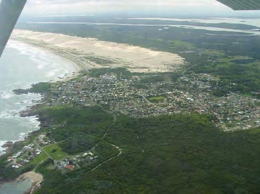
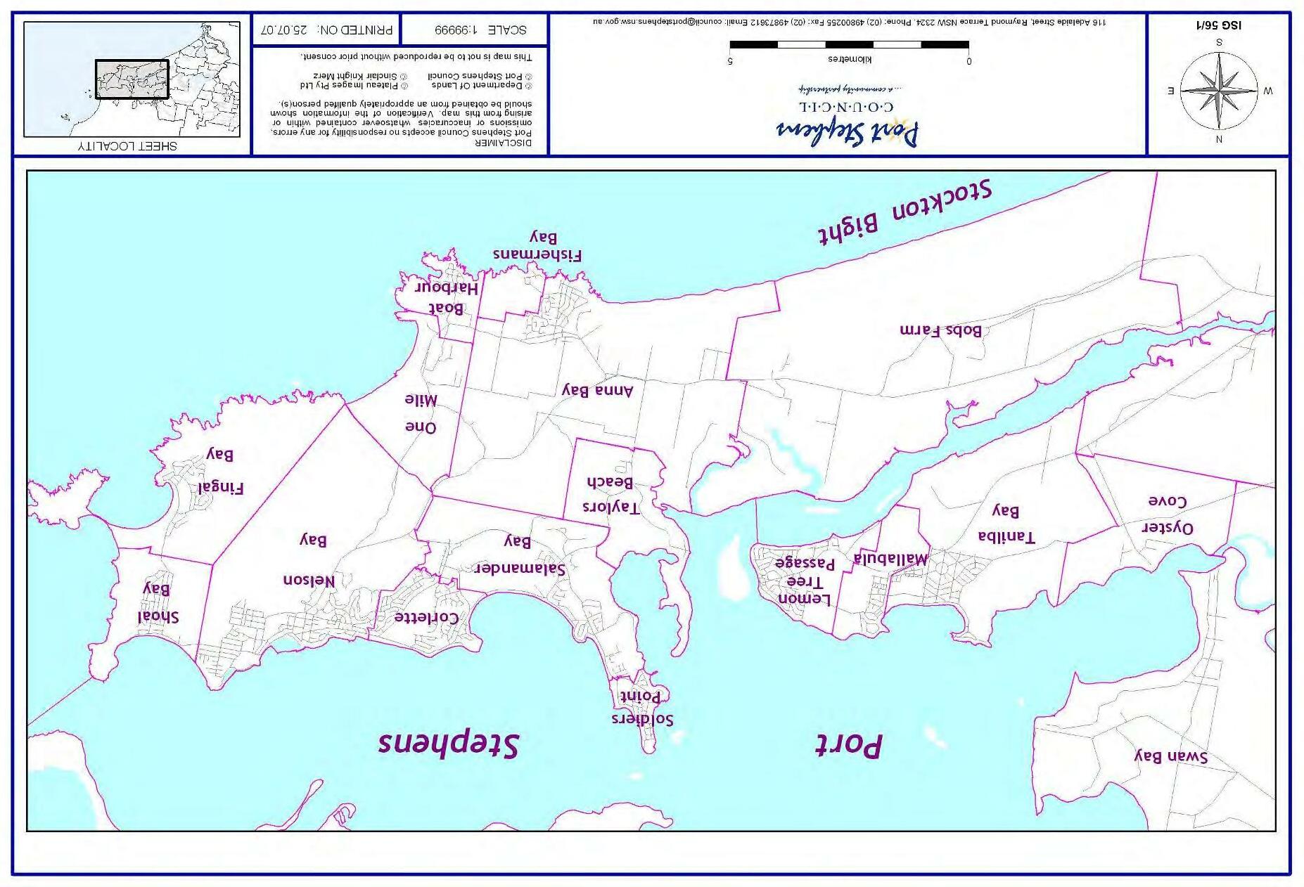
Anna Bay is a small settlement of approximately 2500 people located on the Tomaree Peninsula. The main commercial centre of Nelson Bay is 9km to the north east and Salamander commercial and community centre is 5km to the north. The villages of Fisherman’s Bay and Boat Harbour lie to the east (Figure 1).
2.2 Anna Bay Landscape Setting
Anna Bay is situated on a red-brown coloured volcanic outcrop bounded by a continuous treed ridge to the north, the Tasman Sea foreshore and parkland to the south, Stockton Sand Dunes to the west and rising National Park land to the east
In low-lying areas pockets of native paperbark trees provide strong character elements around and through the town. The main street runs east-west and the large paperbark stand in low lying land immediately to the south forms a backdrop to the retail area and hotel.
Eucalypts, angophora and banksia are typical tree species in elevated areas.
The main entry from the west is along Gan Gan Road travelling through semi-rural land, along the coastline then crossing a paperbark lined channel, before entering the town centre. This entrance sequence is unusual and distinctive and is an important attribute of the town. From the east Gan Gan Road crosses two vegetated corridors that contain large canopy angophoras and eucalypts (figures 2 and 3).
2.3 History
Aboriginal people have a long and ongoing relationship with the land in Anna Bay and Stockton dunes. Birubi Point is formally recognized as an Aboriginal Place and is an area of significant cultural heritage for the Worimi people. Large parts of the Stockton dunes are also under management by the Worimi as Worimi Conservation Land (Figure 4).
Fishing and mixed farming were the main reasons for later European settlement of Anna Bay. After World War II, with rising prosperity and new roads linking Anna Bay to Newcastle, the small settlement became a holiday destination. It also provided a gateway to the Stockton Bight and sand dunes.
With regional population growth and improved access, Anna Bay has become an established town, although it has never had a strong economic base to generate jobs and wealth. Development of the town has been through incremental growth resulting in a discordant town centre and a poor public realm.
2.4 Land Use
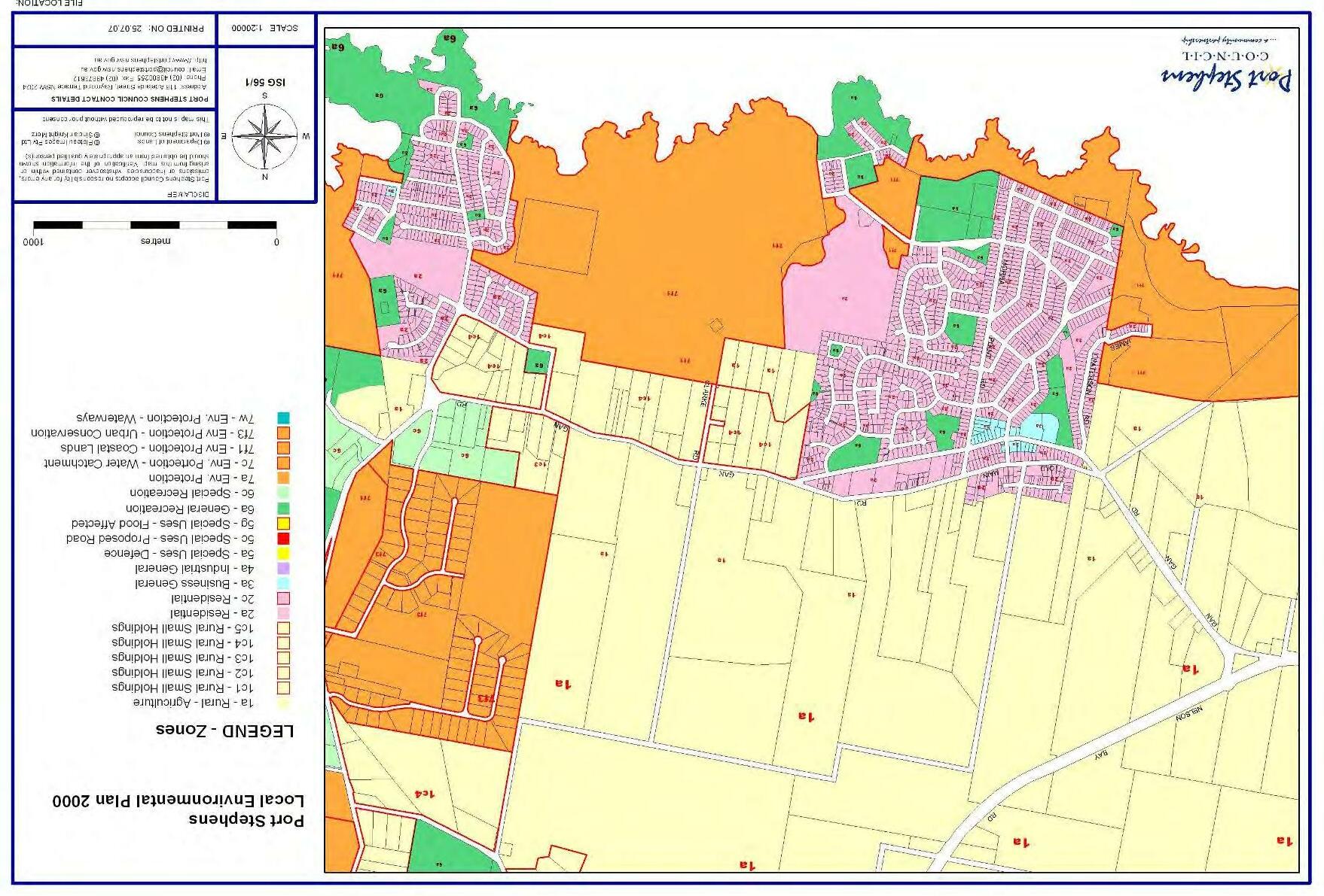
Refer to Figure 5 for existing zoning under the Port StephensLocalEnvironmentalPlan2000
Agricultural
Outside of the town the majority of land is zoned for agriculture. This is despite limited agricultural activity, pressure for development and the presence of areas of significant vegetation.
Commercial
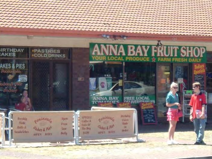
The general quality and age of the buildings on commercially zoned land in the town centre reflects a history of low investment and a small primary trade area. This is compounded by the inability of the town to attract passing trade as it is located off the main transport corridor linking the Tomaree Peninsula to Raymond Terrace and Newcastle.
The town centre is separated from the coastline by residential land. To the west, the northern side of Gan Gan Road has residential lots that back onto the street. This does provide an opportunity for additional development that can support a main street environment.
Approximately 35,000 square metres of land is currently zoned for commercial/retail land uses in the town centre. Uses include a tavern adjacent to a small shopping centre, additional retail, take-away food and cafes, a hardware shop, mechanical repairs and a service station. Pedestrian based services and uses tend to occur to the west of the town centre while other forms of retail tend to occur to the east, although this is not consistent.
Industrial
Industrial land uses are currently located within the town centre on land zoned for commercial purposes. These uses generally detract from the streetscape and appearance of the town centre, and their presence suggests that there is a lack of alternative sites for industrial land uses in Anna Bay.
AnnaBayStrategyandTownPlan
2
2. Background
Residential
Residential development is focused around the town centre, with the majority of dwellings located between Gan Gan Road and the Pacific Ocean. There are also a number of dwellings scattered across the rural landscape.
The newer residential area of Anna Bay is characterized by cul-de-sac pattern of subdivision. Rectangular shaped blocks characterise the older residential area of Anna Bay.
Residential expansion has been limited by natural constraints such as flood prone land, vegetation and the Stockton Sand Dunes.
2.5 Built Form and Character
Built form concerns the form, massing and scale of buildings in the street, and the relationship of buildings to each other and the street or open space. Materials, articulation, colours and detailing, and the landscape setting determine building character.
Anna Bay has experienced incremental growth, and a variety of residential and commercial building types is evident.
Residential Areas
Most housing in Anna Bay comprises single detached dwellings. Earlier cottages are lightweight timber frame construction on piers and more recent dwellings are typically brick veneer construction on a concrete slab. More recent medium density development is generally two storey townhouses or duplexes with rendered masonry finishes. There are few buildings old or new that reflect elements of traditional seaside architecture.
On recently developed sites double garages and extensive driveway pavement dominate the streetscape. Development of steeper sites with slab on ground construction has necessitated extensive and often unattractive cut and fill retaining and fencing solutions.
There is a limited amount of tree planting in front yards and coordinated street tree planting.
Recent medium density development is located on sites with higher aesthetic amenity near the coast and on the hillside east of the town. Medium density development close to the main street that would provide good access to shops and services has been limited.
Town Centre
In the town centre buildings are relatively small in scale, generally simple slab on ground construction of one and sometimes two storeys. Use of face brickwork, rendered masonry, timber, tile and metal sheeting is common. Pitched gables and hipped roofs tend to predominate, with some use of skillion and curved roof forms. The fragmented built form does not define the street space or contribute to good pedestrian amenity.
2.6 Road and Street Network
Anna Bay is an isolated town located off the main transport corridor of Nelson Bay Road that links the larger more prosperous towns around the Port to Raymond Terrace and Newcastle.
The primary trade area for Anna Bay is the town itself with a secondary trade area including Fisherman’s Bay, Boat Harbour, One Mile and Bob’s Farm. For higher order retail and services, Anna Bay residents travel to Salamander, Nelson Bay, Newcastle or Raymond Terrace.
The movement network within Anna Bay itself is focused on Gan Gan Road in the vicinity of the commercial area (Figure 6).
The town centre is accessed primarily by car however there is potential to improve access by alternative modes of transport including walking and cycling.
Anna Bay experiences a large increase in traffic during holiday periods. Large amounts of 4WD traffic accessing the Stockton Sand Dunes and Birubi Point via local streets has undesirable impacts on local traffic and residential amenity, particularly along James Paterson Street.
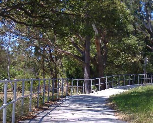
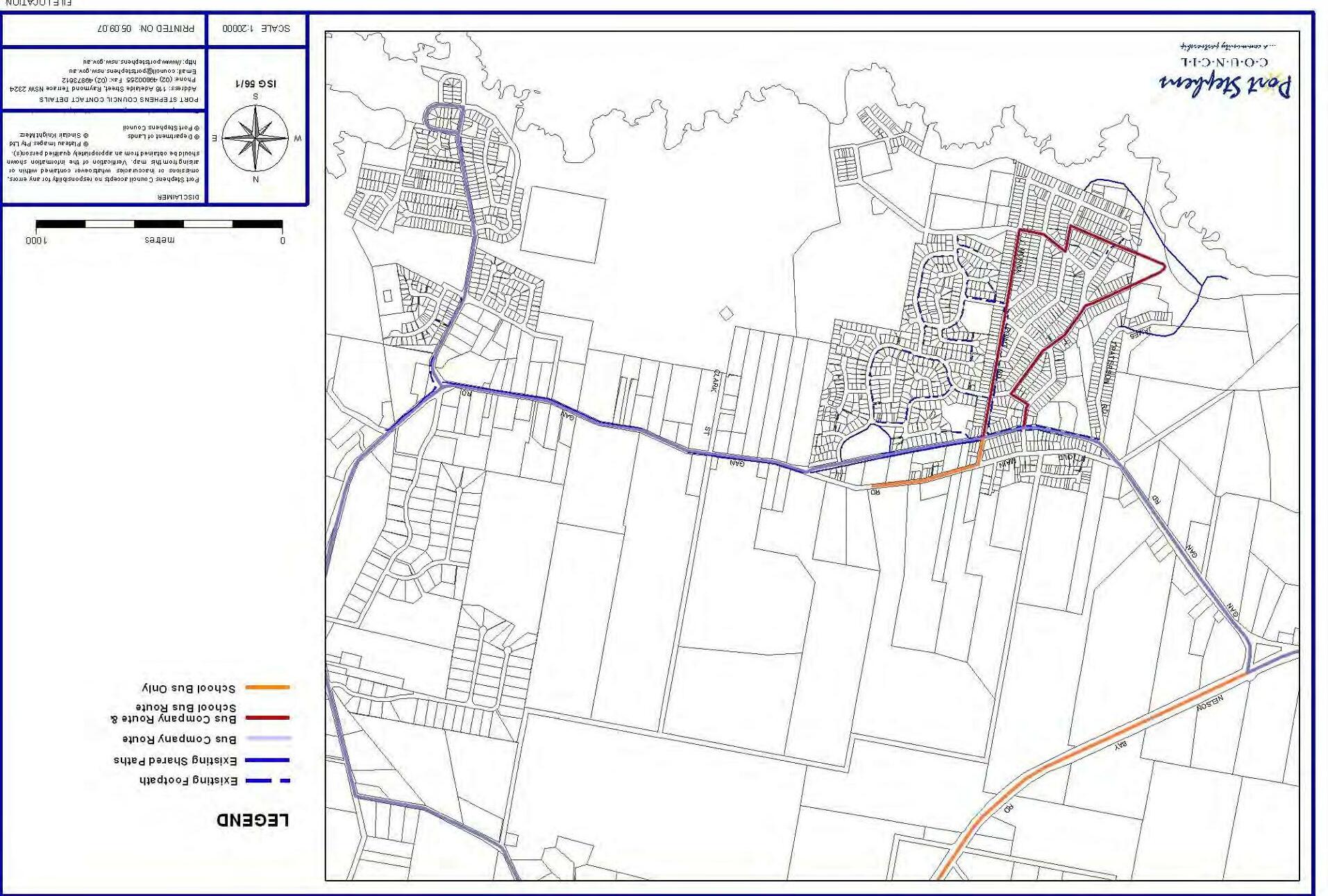
2.7 Footpaths and Cycleways
Pedestrian access from the town centre to Birubi Point is poor. The route to the beach and surf club via James Paterson Street is narrow with no formal footpath or cycleway and is unattractive.
The paperbark lined creek south of the town centre has been degraded by dumping and weed growth but has the potential to provide a pedestrian link from the main street area to Shelley Beach.
A dedicated cycleway is being constructed along Gan Gan Road to the east.
AnnaBayStrategyandTownPlan
3
2. Background
2.8 Community Facilities
The dispersed nature of settlement within Port Stephens makes the provision of a full range of facilities and infrastructure difficult to achieve in each town for reasons such as economies of scale. This is one of the relevant disadvantages of living in a small coastal town.
Existing community facilities in Anna Bay include a primary school, Rural Fire Service station, a small public hall, a pre-school in the multi-purpose community centre and a surf club. Higher order services are provided in centres such as Salamander Bay, Nelson Bay and Raymond Terrace (Figure 14).
AnnaBayStrategyandTownPlan
4
3. Planning and Policy Context
The Anna Bay Strategy and Town Plan is, in part, responding to demographic trends in the locality and current planning policy.
3.1 Demographics and Housing
Population
Anna Bay is located within a statistical district that includes Anna Bay, Boat Harbour, Fisherman’s Bay, One Mile and Bobs Farm. The population of this district at the 2006 census was 5452 persons. Anna Bay had a population of 2441 persons.
The availability of development sites will be a large factor in population growth in Anna Bay.
Household Type by Number of Persons
The following figures show the household type by number of persons in Anna Bay specifically:
One person households: 173 Two person households: 303 Three or more person households: 407 (ABS 2006)
The figures show that there are slightly more people in Anna Bay that live in either one or two person households than three or more person households. This indicates that the traditional family structure is no longer dominant in Anna Bay, with a shift towards couples with no children or lone person households. The consequence of this is that there is a need to cater for a wider variety of dwelling types.
Household Size
The following figures show the existing and future estimated average household size in the district: 2006: 2.49 2011: 2.38 2026: 2.31 (ABS 2006)
The figures show that the average household size is predicted to decline over time. This is a continuation of an existing trend within Port Stephens and the Lower Hunter. This also supports the need to cater for a variety of dwelling types.
Dwelling Type
The following figures show the number of different types of existing housing in Anna Bay: Detached houses: 780 (86%) Townhouses: 68 (8%)
Flats/Units/Apartments: 24 (3%)
Other dwelling types: 31 (3%) (ABS 2006)
These figures show a historical preference for separate houses in Anna Bay. However, demand for townhouses is also demonstrated by recent developments in proximity to the town centre. The continued reduction in household size supports the additional supply of townhouses and flats/units/apartments, as well as the continued supply of detached houses.
Employment and Education
The following figures show the number of residents in Anna Bay employed in various industry sectors: Retail trade: 204
Accommodation, cafes and restaurants: 130 Construction: 121 Manufacturing: 95 Health and community services: 78 Government administration and defence: 73 Property and business services: 68 Education: 49
Wholesale trade: 36 Transport and storage: 34 Personal and other services: 30 Cultural and recreational services: 21 Finance and insurance: 18 Electricity, gas and water supply: 12 Agriculture, forestry and fishing: 9 Mining: 3
Non-classifiable: 9 Not stated: 33 Total: 1023 (ABS 2006)
The figures show that most people in Anna Bay are employed in retail, accommodation, cafes and restaurants, followed by construction and manufacturing.
There are only 9 people employed in the agriculture, forestry and fishing sector. This is consistent with the general historical shift away from employment in this sector over time and indicates that Anna Bay is no longer a predominantly agricultural area.
AnnaBayStrategyandTownPlan
5
3. Planning and Policy Context
Travel to Work
The following figures show the way people in Anna Bay travel to work (one method only):
Bus: 20
Car (as driver): 603 Car (as passenger): 79 Truck: 29
Motorbike: 6
Bicycle: 9 Walking: 15
Worked at home: 42 (ABS 2006)
The figures show that the car – and motorised transport generally -is easily the dominant method of travel to work. More sustainable modes of transport such as walking and cycling are much less popular modes of transport.
The dominance of travel to work by car indicates that many people travel outside of Anna Bay for employment. This is likely to be because of greater job opportunities in other major centres.
3.2 Planning and Policy Context
Lower Hunter Regional Strategy
The NSW Government adopted the Lower Hunter Regional Strategy in October 2006. Anna Bay is identified as a proposed urban area with boundaries to be defined through local planning.
The strategy supports the implementation of neighbourhood planning principles, including:
A range of land uses to provide the right mix of houses, jobs, open space, recreational space and green space.
Easy access to major town centres with a full range of shops, recreational facilities and services along with smaller village centres and neighbourhood shops.
Jobs available locally and regionally, reducing the demand for transport services.
Streets and suburbs planned so that residents can walk to shops for their daily needs.
A wide range of housing choices to provide for different needs and different incomes. Traditional houses on individual blocks will be available along with smaller, lower maintenance homes, units and terraces for older people and young singles or couples.
State Environmental Planning Policy No. 71 Coastal Protection and the NSW Coastal Design Guidelines
The Anna Bay area in general is subject to the provisions of SEPP 71, which has a number of aims and objectives based around the protection of the NSW coast.
Under the NSW Coastal Design Guidelines Anna Bay can be classified as a coastal town. The following principles are applicable to guide its future growth:
Creating functional urban areas in close proximity to areas of natural beauty;
The consolidation of future growth where infrastructure, quality buildings and pedestrian friendly streets may be at present under utilized;
Using the town as a model for new neighbourhoods and infill developments;
Upgrading public transport, cycle and pedestrian systems; and Regeneration of degraded natural assets.
Port
Stephens Community Settlement and Infrastructure Strategy 2007 (CSIS)
The CSIS sets down Council’s policy framework for managing urban growth and building communities in Port Stephens.
For Anna Bay the CSIS identifies:
Anna Bay as a new release area of up to 200 dwellings over 15-20 years.
Average persons per dwelling 2.1
Average density is 10-12 dwellings per hectare (net). Projected population increase of approximately 300 persons.
These figures are a general guide and may change as a result of detailed planning.
The CSIS also contains Sustainability Principles and Criteria to guide development and are based around settlement structure and movement network, infrastructure services and facilities, quality places to live, natural areas, and resources and economics and employment.
AnnaBayStrategyandTownPlan
6
3. Planning and Policy Context
Port Stephens Local Environmental Plan 2000
Port Stephens Local Environmental Plan 2000 is the planning instrument that sets down the current zoning that applies to land across the LGA and the type of development that is permissible within each zone.
Draft Urban Management Plan and Design Guidelines 2002
The Draft Anna Bay Urban Management Plan and Design Guidelines (June 2002 and publicly exhibited from 1st August 2002 to 4th October 2002) identified opportunities to accommodate new development in the area consistent with the principles of the superseded PortStephens UrbanSettlement Strategy and that protects and develops the local identity and character of the town. The document also incorporates initiatives from an Urban Housing Workshop held in November 1999, outcomes from a Councillors Workshop held in August 2001, and an Anna Bay Community Workshop held in February 2002.
Draft Anna Bay Local Area Plan 2004
Anna Bay Local Area Plan (July, 2004 and publicly exhibited 4th March 2004 to 4th May 2004) was developed to provide broad strategic land use policy directions for future development in the Anna Bay area.
The Local Area Plan stated that development should: Encourage infill opportunities with greater mix of uses and densities within the town centre, concentrating on a walkable (800m radius) catchment to promote economic and social vitality and viability to the town centre.
Protect the topography and vegetation as an important influence on the sense of arrival and departure of Anna Bay.
Create a new neighbourhood at Anna Bay east with shops, services and a dual use drainage resereve/park adjacent to Gan Gan Road that support the new community and complement the higher order shops and services located at the main town centre.
The new neighbourhood at Anna Bay east is to be linked to the town centre by Gan Gan Road and associated footpaths and bike paths.
Support home based businesses in existing and new residential areas within 400 metres of existing and new centres.
The scale and character of new development visible from streets and parks needs to reflect the coastal location and feel of Anna Bay.
Any rezoning requests for land on either side of Nelson Bay Road away from the town will require the preparation of a Local Environmental Study.
Development in areas away from existing and new centres is preferred on land that is already substantially cleared. Development should enhance the natural attributes of the site with a focus on ecotourism and nature based opportunities.
Large-scale permanent residential away from existing and new centres is not appropriate.
Residential development ancillary to and integrated with ecotourism and nature based opportunities should only be considered in future zonings where it can be demonstrated that the residential component is of exceptional design quality, and the overall social, economic, and environmental benefit to the broader community, is above and beyond which could have been achieved had the residential component been located more closely to the Anna Bay township.
Draft Anna Bay North Structure Plan 2005
Draft Anna Bay North Structure Plan (2005 and publicly exhibited from 2nd June 2005 to 29th July 2005) identified the flooding, drainage and ecological issues and subsequent management requirements relating to the possible development of land adjacent and to the north and east of the town.
Protect and enhance the visual character of the surrounding coastal village environment and the approach to Anna Bay along Gan Gan Road.
Ensure new development is sympathetic in scale and character to its surrounding area, and mitigate potential visual impacts on surrounding residents.
Increase tree cover where possible.
Restrict urban development on ridgelines and increase tree cover in these areas.
Plan for the development of future cyclist and pedestrian linkages between key areas.
Allow for future integration of drainage areas and natural vegetation into an open space system.
Design a street system that allows easy access and is legible.
AnnaBayStrategyandTownPlan
7
3. Planning and Policy Context
Highlight important town approaches to create a sense of place.
Locate intersections at logical locations.
3.3 Previous Consultation & Feedback
The preparation of past strategies and guidelines involved consultation with the community and a number of workshops and meetings. This section summarises the feedback received on the Urban Management Plan and Guidelines, Local Area Plan and AnnaBayNorthStructurePlan
It can be summarised that residents of Anna Bay have a variety of expectations and desires for the future of the town, with the protection of lifestyle and the environment a common theme. Many landowners express the desire for more development. The DraftAnnaBayStrategyandTown Plan 2007 tries to achieve a reasonable balance between these expectations as well as meet the requirements of the current legal and policy framework.
Draft Anna Bay Local Area Plan 2004
A community workshop was held in October 2003 to identify what the community considered are the issues and opportunities for Anna Bay in the preparation of the Anna Bay Local Area Plan. The following matters were raised:
Protection of natural areas and important attractions and promotion of ecotourism facilities.
Encouragement of tourism based development with potential for integrated tourism and housing.
Need to improve existing facilities, provide more sporting, recreational and educational facilities.
Need to improve vehicular and pedestrian links within and around Anna Bay including more car parking and better infrastructure.
Need to promote a sense of community, pedestrian permeability and cohesion within Anna Bay.
Protection of the current lifestyle and the beach/village/rural character of Anna Bay.
Promotion and provision of greater housing choice and affordability.
Need to increase the economic activity and viability within the town.
A regular review of the Plan to ensure it continues to be applicable and proactive.
In general, residents of the Anna Bay have a strong sense of community and are seeking a safe, sustainable and attractive town that provides adequate public facilities and retains a local identity.
Draft Urban Management Plan and Design Guidelines 2002
In preparing the Urban Management and Design Guidelines, a community workshop was held in February 2002 to clarify and confirm resident likes and dislikes and to identify specific opportunities for the changing nature of the town.
The following positives were identified: Beaches – fishing, boating and surfing. Village atmosphere. Rural atmosphere.
Environment – variations, biodiversity, wetlands, bushland, vegetation and wildlife. Tomaree National Park. Landform – headland and sand dunes. Access to Nelson Bay.
The following negatives were identified: Type of development – massing of buildings, lack of privacy, ugliness and cluster-type developments.
Lack of infrastructure – No kerb and gutters, limited safe and accessible paths.
Lack of social support and no ambulance. Limited employment and youth facilities. Loss of vegetation and biodiversity. Drainage.
The following opportunities were identified: Upgrade town centre.
Increase height limit of commercial land to 12m. Proposal to open Old Main Road.
Provide large 1/2 acre blocks north of ridge. Increase amount of residential land.
AnnaBayStrategyandTownPlan
8
3. Planning and Policy Context
Draft Anna Bay North Structure Plan 2005
Submissions received for the Anna Bay North Structure Plan raised the following issues:
Current access to the beach is poor.
Insufficient parking at Birubi Headland.
Heavy traffic on James Paterson Street accessing Birubi Headland.
Insufficient parking in the commercial area.
Lack of tourist accommodation.
Main street is unattractive and in need of rejuvenation.
Compensation for landowners whose land is marked for conservation.
Partly cleared land is identified for conservation.
Flooding and drainage.
Fire hazard of vegetated areas.
Accuracy of koala habitat mapping.
The desire for Old Main Road to remain closed.
The number of 4 wheel-drives accessing the service station for air and water.
Adequate provision of recreation facilities.
The ability of sewer and water infrastructure to cope with expected growth.
AnnaBayStrategyandTownPlan
9
4. Constraints on Development
4.1
Flood Prone Land and Drainage
Flood Prone Land
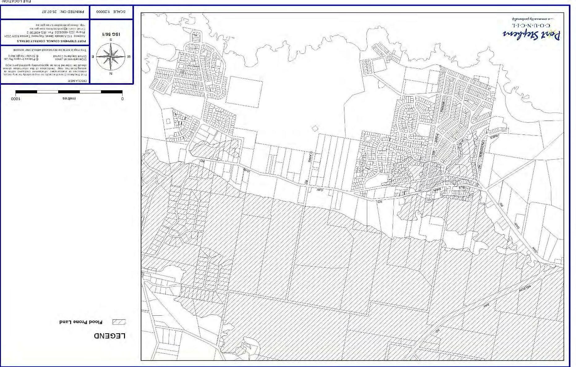
Large areas of land in Anna Bay are mapped as flood prone and this represents a significant constraint to the expansion of the town, particularly to the north of the sand ridge and in proximity to the town centre. The type of vegetation that is present on low lying land in Anna Bay provides evidence that the land is flood prone (Figure 6).
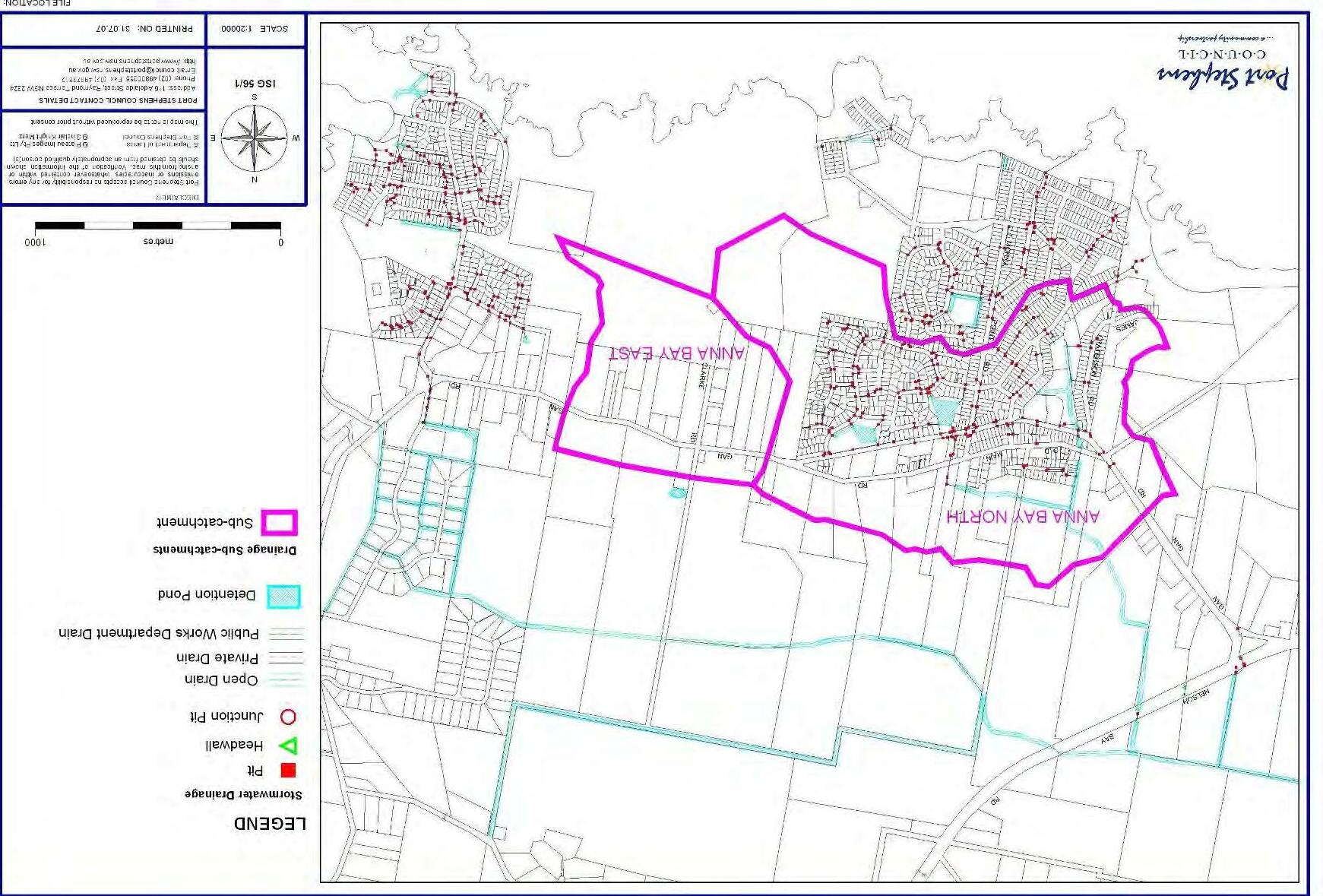
Drainage
Drainage problems exist particularly in the vicinity of the town centre and Anna Bay East. There is a ridge which runs approximately along the Old Main Road alignment. Land to the south of this ridge drains south into three locations south of Gan Gan Road being McKinleys swamp, the dry detention basin at the rear of Anglers Drive, and the wet detention basin at Essington Way. These three locations are connected by pipelines which eventually drain to the Anna Bay Main Drain after discharging into an open channel known as the Fern Tree.
Anna Bay East forms a natural basin with no natural outlet. With increasing development both within and outside the Anna Bay catchment area, the potential impacts on the performance of the drainage system must be considered.
Two previous studies have been carried out to assess the impacts of development in Anna Bay on the drainage network. They are the Anna BayCatchment Drainage and Flood Study Masterplan (SKM 1995) and Drainage Investigation Report Anna Bay North Structure Plan (Parsons Brinckerhoff 2004). These studies investigated different development scenarios however they may provide assistance in future drainage investigations.
Drainage -Anna Bay North
A significant portion of the low-lying area to the north of the town centre and natural ridge is inundated during the 100-year average recurrence interval storm event. Some limited new development in this area was identified and assessed in the past drainage studies. Flood modelling showed that a limited amount of development would not worsen existing flood levels in this northern area.
An engineered floodway immediately to the north of the town centre was suggested as an option to further investigate to determine whether flood levels could be improved. A preliminary estimation for this floodway suggested a small reduction in the flood level may be achievable with further detailed design
calculations. Any rezoning and filling of the floodplain area will require the developer to further develop the flooding and drainage study and implement works as required.
Drainage -Anna Bay East
This area forms a natural basin and therefore has local flooding problems with all stormwater draining to an existing depression located adjacent to Gan Gan Road and Clark Street. New residential development in this area will require measures to ensure existing conditions are improved. They include two large detention basins, one located in the depression and one located north of the sand ridge. Flood modelling has indicated that the size of these basins will be very large. An associated drain linking these basins will need to be placed through the sand ridge to the north (Figure 7).
4.2 Flora and Fauna
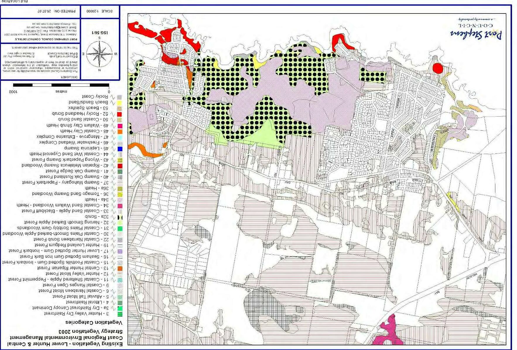
Vegetation Communities
The two major vegetation communities observed in the study area are Swamp Mahogany Paperbark Forest and Coastal Sandy Apple Blackbutt Forest, with the latter being the dominant vegetation community. The general ecological condition of the study area varies from low to medium condition (most of the Coastal Sandy Apple Blackbutt Forest) to medium to high condition (areas of Swamp Mahogany Paperbark Forest).
No threatened plant species were observed, however potential habitat for Tetratheca juncea, Diuris Arenaria and Diurispraecox exists.
Swamp Mahogany Paperbark Forest is listed as part of an Endangered Ecological Community under the ThreatenedSpeciesConservationAct1995.
The Lower Hunter and Central Coast Regional Environmental Management Strategy or LHCCREMS has mapped vegetation communities in the area at a broad scale (Figure 8).
Koala Management
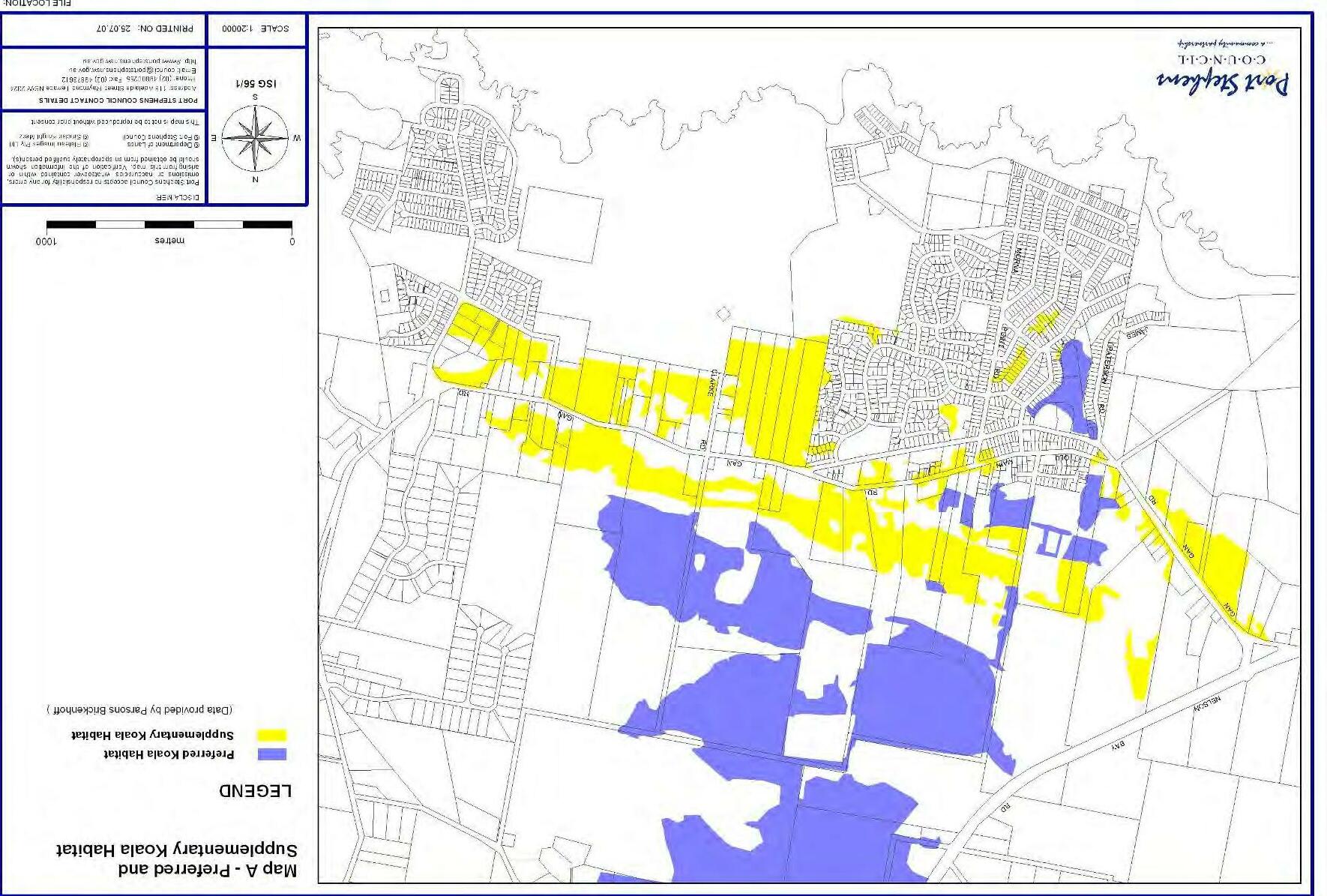
The principal document guiding the management of koalas in Port Stephens is the Port Stephens Comprehensive Koala Plan of Management or KPoM. It describes the Anna Bay area as comprising one of the most significant koala habitats on the Tomaree Peninsula. Clearing has isolated several small sub populations in the area. The two common vegetation communities present in the area, Swamp Mahogany Paperbark Forest and Coastal Sandy Apple Blackbutt Forest, are identified as preferred and supplementary koala habitat respectively (Figure 9).
AnnaBayStrategyandTownPlan
10
4. Constraints on Development
Koalas are listed as a vulnerable species in the Threatened Species Conservation Act 1995 and are also recognised as an umbrella species that indicate the general health of the environment. On this basis the protection of koala habitat is important to the quality of the environment in Anna Bay.
Council has undertaken a review of koala habitat and movement based on a range of data, attached as Anna Bay Town Plan – Ecological Advice. Key recommendations include:
Avoid impacts to existing areas of Swamp Mahogany Paperbark Forest.
Avoid development of roads, infrastructure or dwellings in areas of Preferred Koala Habitat.
Minimise the removal of isolated preferred feed trees that occur near preferred koala habitat.
Maintain movement corridors of 100m width between the preferred koala habitat and larger and significant preferred koala habit areas.
Give priority to re-vegetation with preferred feed trees (Swamp Mahogany) to enlarge size of remnant habitat patches.
Allow environmental living lots only (with requirements for tree retention and koala friendly fencing and prohibition of dogs) within koala movement corridors.
Introduce reduced speed zones signage and traffic calming where koala movement bisected by Gan Gan Road. corridors are
A map is attached showing movement corridors (Figure 10). habitat areas and
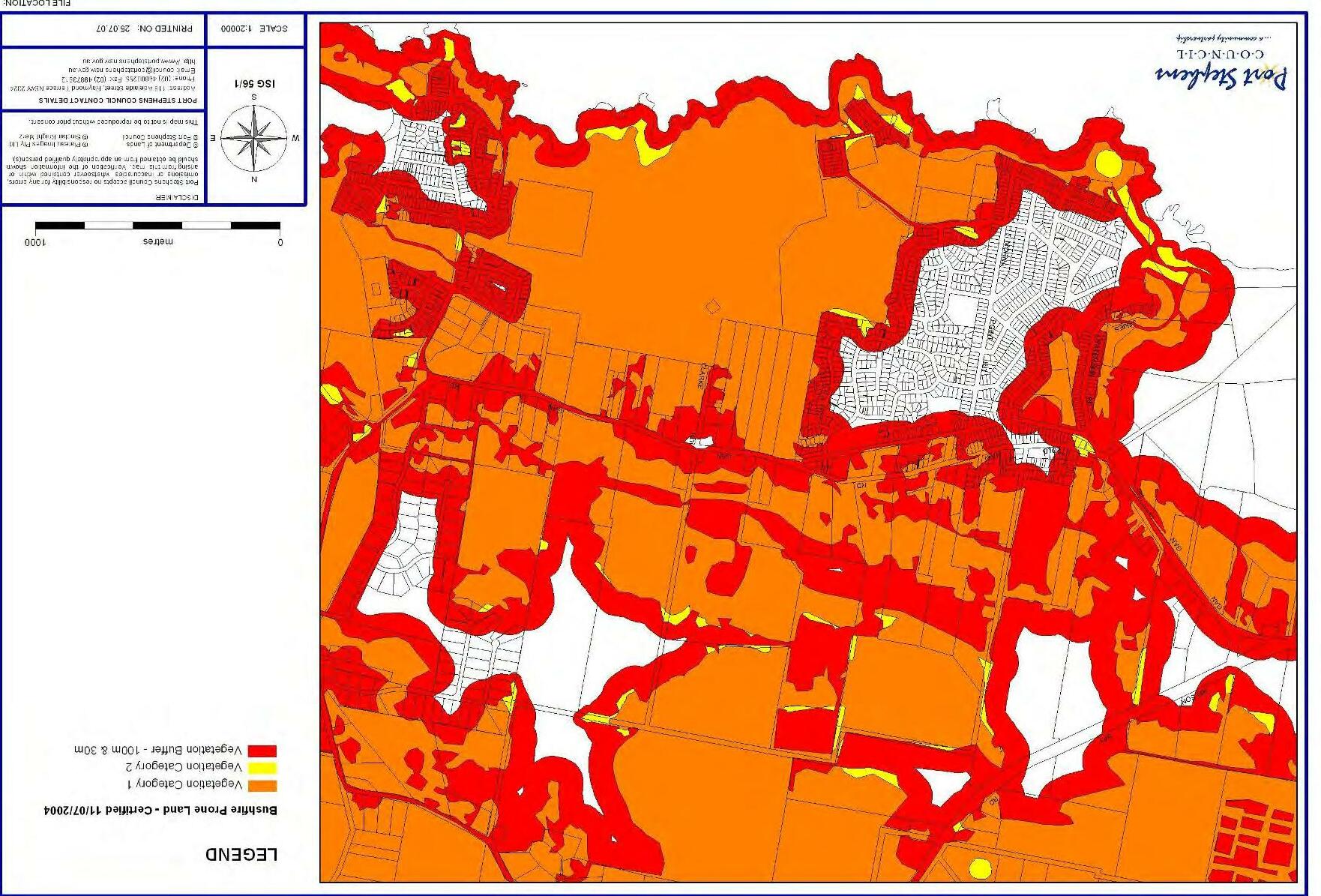
4.3 Bushfire Prone Land
The Rural Fires Act 1997 requires development to comply with the Planning for Bushfire Protection Guidelines where development is within land identified as bushfire prone. Most of the land in Anna Bay is mapped as bushfire prone. The guidelines assist in identifying the level of bushfire threat and determining asset protection zones for protection during bushfire events.
Council’s LGA Wide Bushfire Hazard Map was prepared using the vegetation predicted on site as mapped by the LHCCREMS (Figure 11).
The following requirements are likely to be incorporated into the rezoning and development of greenfield sites:
An APZ for each lot adjacent to bush land (located within allotment boundaries).
Perimeter roads (with a road reserve of 16-20m) which link to the major road system at an interval of no greater than 500m.
Dead ends should be avoided where possible and not be any greater in length than 200m.
4.4 Steep Lands
The landform is dominated by an east – west linear ridge with a relief of 15m to 20m with moderate to steep side slopes. A review of the Port Stephens 1:100,000 Soil Landscape Series Sheet 9332 and the accompanying report (Murphy 1995) records the ridge as a variant of the Shoal Bay Aeolian landscape. This landscape comprises well-drained dunes of low fertility, with steep slopes and potential for foundation hazard due to potential slumping of cut batters.
The Draft Anna Bay North Structure Plan defined steep land as land with a slope in excess of 25% (1 vertical to 4 horizontal). This is appropriate for the loose non-cohesive dune sand soil conditions found at this site. Slopes interpreted from aerial photographs were verified by selected ground truthing (Figure 12).
Site measurements of fill batter slopes at the market garden on top of the dune to the east of Anna Bay indicate slopes of up to 80% north of the crest. Some leaning or curved trunk trees (indicative of slope creep movements) were noted in the north facing slopes of the main portion of the ridge. Extensive cut and fill earthworks in the steeply sloping terrain areas may initiate slope instability.
Parts of the northern ridge and a ridge to the south have over 25% slope and are unsuitable for intensive development.
The slope stability section in the Draft Anna Bay North Structure Plan recommends:
Restrict earthworks within steeply sloping terrain areas to a maximum of 1.5m cut or fill.
Avoid construction of major access roads in the steep areas.
Avoid extensive clearing of vegetation.
Control surface drainage to minimise ponding and concentrations of flows.
Development be consistent with good hillside practice as defined by Landslide Risk Management Concepts and Guidelines (AGS, 2000).
Development be subject to the preparation of a landslide risk assessment report and geotechnical review of development plans prior to approval in accordance with the Landslide Risk Management ConceptsandGuidelines (AGS, 2000).
AnnaBayStrategyandTownPlan
11
4. Constraints on Development
4.5 Stockton Sand Dunes
Anna Bay is the gateway to the Stockton Sand Dunes that stretch southwards for 32 kilometres along the coastline and cover area of approximately 2500 hectares. The dunes are the largest continuous mobile sand mass in eastern Australia and at some parts rise up to 30 metres above sea level. This landscape is part of the Worimi Conservation Lands that are co-managed by NSW Parks and Wildlife and the Worimi Local Aboriginal Land Council.
Parts of Birubi Point area are formally declared as an Aboriginal Place under the National Parks and Wildlife Act 1974. The values of the place include burials, a ceremonial site, an area rich in natural resources, and extensive archaeological material important for teaching current and future generations about Aboriginal culture (refer to NSW Government Gazette No. 54, 20th April 2007) (Figure 4).
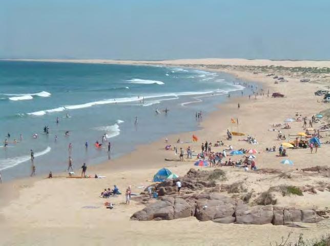
The area is subject to heavy recreational use and is a popular tourist destination. The management of recreation in the area is an ongoing concern. Sand extraction also occurs in the area. There is a need for a coordinated approach to management of the land.
AnnaBayStrategyandTownPlan
12
Figure 1 Settlements of the Tomaree Peninsula
AnnaBayStrategyandTownPlan
13
AnnaBayStrategyandTownPlan
14
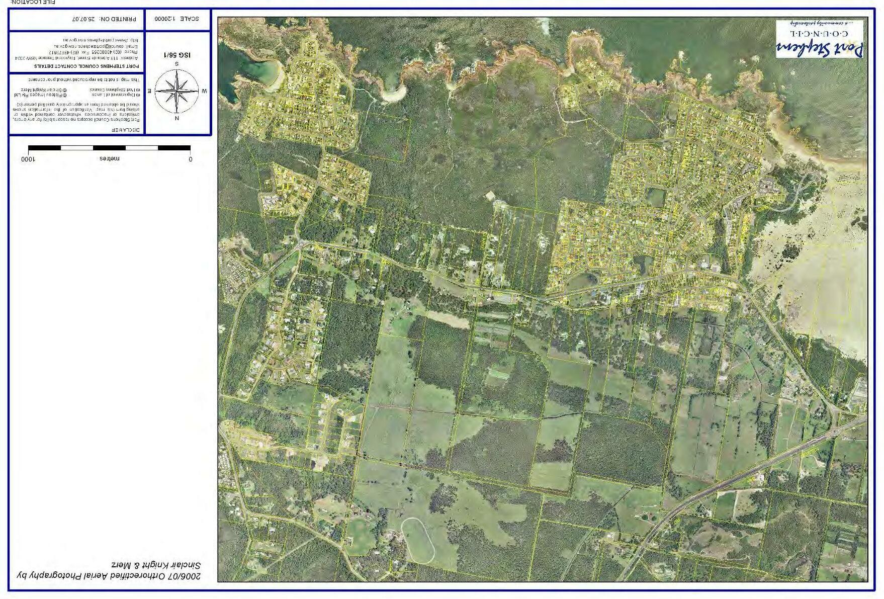
Figure 2 Anna Bay Aerial Photograph 2006
AnnaBayStrategyandTownPlan
15
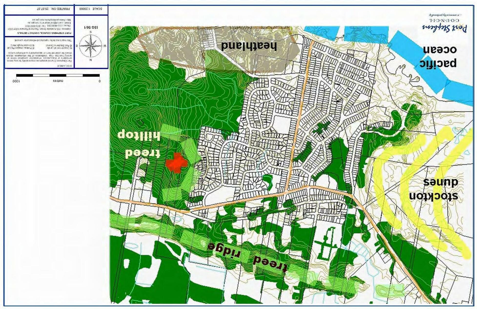
Figure 3 Landscape Setting of Anna Bay
andNationalParkAreas
AnnaBayStrategyandTownPlan
16
Figure 4 BirubiPointAboriginalPlace
AnnaBayStrategyandTownPlan
5
17
Figure
Anna BayExistingLandUse Zoning(PortStephens LEP2000)
AnnaBayStrategyandTownPlan
18
Figure 6 Anna Bay Flood Prone Land
Anna BaySub-Catchments andExisting andProposedDrainage Infrastructure
AnnaBayStrategyandTownPlan
19
Figure 7
Figure 8 ExistingVegetation Communities (Lower Hunter andCentralCoastRegionalEnvironmentalManagementStrategy2003)
AnnaBayStrategyandTownPlan
20
AnnaBayStrategyandTownPlan
21
Figure 9 Preferred andSupplementaryKoala Habitat(DraftAnna BayNorthStructure Plan 2005)
AnnaBayStrategyandTownPlan Figure
22
10 SignificantVegetation andLinkingClearedLands
Figure 13 ExistingFootpaths, SharedPaths andBus Routes
AnnaBayStrategyandTownPlan
25
Figure 14 Existing Recreation Areas and Community Facilities
AnnaBayStrategyandTownPlan
26
AnnaBayStrategyandTownPlan Figure 15
27
Anna Bay Town Plan – Land Uses
5. Strategic Directions
The Town Plan (Figure 15) is a strategic response to the constraints and opportunities in Anna Bay and the policy and legal framework. It is also informed by the previous background studies and draft plans.
5.1 A Vision for Anna Bay
Anna Bay has a future as a small and vibrant town offering a mix of dwelling types and business opportunities and a quality natural environment. It will have a pleasant main street with a mix of retail and office space for local and visitor patronage, and shop top housing or tourist accommodation.
5.2 Key Strategic Directions
The Town Plan is based on the following strategic directions:
1) Protecting the Landscape Setting
a) Maintains and protect the treed ridge to the north of the town above 10m AHD and the treed landscape south of Gan Gan Road above 20m AHD. These areas form the visual and physical containment of the settlement. The 10m and 20m AHD can be reviewed if it can be demonstrated that the removal of vegetation and subsequent development is not visible from a public street park or other public vantage point.
b) A green corridor will enhance the entrance to Anna Bay from the east and west on both sides of Gan Gan Road. Development in these areas must maintain a green entrance to the town.
c) A bushland break will be maintained between the existing town and the proposed neighbourhood at Anna Bay East. Development in this bushland break area will comprise larger environmental living lots that retain the large canopy trees and koala food species. This and the school will act to avoid ribbon development and to create a distinction between the two neighbourhoods.
d) A coordinated program of street tree planting will be introduced comprising of local native species such as the Tuckeroo (Cupaniopsis anarcardioides) Broad-leafed paperbark (Melaluca quinquenervia) and Spotted Gum (Corymbia maculata).
2) Protecting Aboriginal Heritage
a) Anna Bay is a place of high importance to the local Aboriginal community. The Birubi Point Aboriginal Place and Worimi Conservation Lands are acknowledged and any proposed development in the vicinity needs to respond to the importance of these places.
b) Any proposed parking areas and access routes to the dunes and beach must located to minimize conflict with areas of Aboriginal significance.
3) Supporting Town Centre Growth
Anna Bay could potentially compete with high amenity towns such as Fingal, Shoal and Nelson Bays and Soldiers Point.
a) To attract new residents, including high income earners and retirees, professionals and creative and entrepreneurial people, the town must provide a range of high quality housing and work or retail spaces.
b) Town centre growth will be supported by an increase in quality mixed-use development on Gan Gan Road and an increase in the population of the town’s primary trade area.
c) Both strategies will; attract investment into the town centre; improve the quality and range of services as well as the quality of the built environment; reduce escape spending; increase convenience and accessibility for local residents; and, reduce travel to retail and commercial services in other towns.
d) The town centre will develop with mixed-use buildings with residences or serviced apartments above shops or professional office space on the street level. A pleasant and lively pedestrian environment would be created by buildings that provide active frontage to the street and by coordinated street tree planting of local native shade trees, shrubs and grasses.
4) Diversity and Quality of Dwellings
The broader economic and demographic trends show that future residents of Anna Bay are likely to have higher incomes and demand a more diverse and higher quality range of housing, goods and services.
a) Higher quality housing and greater diversity of dwelling types that front attractive and pedestrian friendly streets and parks will attract new residents.
b) Greenfield and infill development will provide for quality villa and townhouse development.
5) Supporting Home Based Business
To encourage sustainable employment and transport; home-based businesses will be encouraged within residential zones. To encourage local economic development near the town and near neighbourhood centres dwelling design should allow for areas with independent access on the ground floor.
AnnaBayStrategyandTownPlan
28
5. Strategic Directions
6) Providing Employment Land
A new, small-scale light industrial area will be provided at the western edge of Anna Bay. This area has good transport access to Nelson Bay Rd. It will support relocation of light industrial businesses currently operating on high value land within the commercial centre, and would allow local trades people to set up storage sites or workshops.
7) Improving Recreation Places and Community Facilities
The use and improvement of existing and future community facilities will be encouraged by pursuing opportunities to improve and/or develop existing and further multi-purpose community spaces.
Pedestrian and cycleway connections will be provided and the amenity of parks, reserves and gathering places improved.
b) The Town Plan street and block layout is in response to the natural topography, habitat values, aesthetic values and constraints of flooding, drainage and slope stability. The pattern of streets, blocks and parks is also based on the desired future character and accessibility of each neighbourhood. The appropriate scale, massing and character of future residential and mixed-use development and landscape plantings will serve to enhance each local neighbourhood’s sense of place.
c) Locality specific development controls for Anna Bay will be included in the Port Stephens DevelopmentControlPlan2007.
2) Town Centre Neighbourhood -Main Street West
This precinct is the primary focus for retail and commercial, including indoor and outdoor eating.
5.3 Strategic Directions Neighbourhoods
-
The Town Plan is structured around the town centre and five residential neighbourhoods (Figure 16).
Each residential neighbourhood has access to particular services and facilities within approximately 500m of each dwelling.
Town Centre Neighbourhood – includes main street shopping, mixed uses and surrounding residential dwellings.
School Neighbourhood-includes Anna Bay Public School and Community Facility.
Anna Bay East– includes proposed mixed use development and small dual use drainage reserve/park.
Birubi Neighbourhood – includes beach access, surf club, caravan park, skate park and playground.
Fisherman’s Bay Road Neighbourhood – (southeast quarter of the existing town and land zoned 2(a) Residential that borders on the Tomaree National Park) – includes scout hall, multi-purpose centre and community hall.
1) Neighbourhood Character
a) Each neighbourhood is distinguished by its landscape setting and vegetation, the existing or proposed settlement pattern, and the form and character of buildings.
a) New development should enhance the existing street character that is established by the aggregation of smaller building masses.
b) Future mixed-use buildings would be up to 3 storeys and buildings set back from the property boundary. This reinforces the existing pattern and allows for generous street and landscape planting. Residential uses would occupy the upper levels and car parking would be located at the rear or under buildings.
The number of access driveways are to be kept to a minimum in improve pedestrian focused areas, visual amenity and maximize business frontages. Existing and future businesses should setup one-way access driveways and right-of-carriageways, examples are such as the southern side shopping centre carpark and the off-street rear parking on the northern side of Gan Gan road.
A lane linking Gan Gan Road and Old Main Road will create better circulation within the CBD for pedestrian, cyclist and vehicles to the commercial parking areas, to the right-of-carriageway, as well as for the residential lands immediately to the north.
3) Town Centre Neighbourhood -Main
Street East
This block supports commercial uses that do not necessarily need to be located on a pedestrian focused street. Such uses include service stations and professional offices.
a) Buildings will be a maximum of 2-3 storeys with active street frontage and awnings. Loading bays and car parking would be at the rear. Continuous
AnnaBayStrategyandTownPlan
29
5. Strategic Directions
footpaths and shade trees would provide a pleasant pedestrian environment.
b) Development on the north side of Gan Gan Road between Morna Point Rd and Campbell Avenue should include ground floor commercial uses to create a stronger link to the main street activities on the south side.
4) Town Centre Neighbourhood – Surrounding Residential Areas
This neighbourhood includes a variety of dwelling types and supports future medium density development of villas and townhouses on large sites. These dwellings would be within easy access and walking distance from the town centre and beach, and the vegetated ridge to the north.
It is anticipated that buildings will be a maximum of 2-3 storeys. Villa and townhouse development will be encouraged.
The western connection of Old Main Road onto Gan Gan Road occurs opposite the 4WD access point where vehicle access onto the beach is to be concentrated. The 100m long Cul-de-sac is to be relocated through redevelopment areas too avoid a four-way intersection and future traffic conflicts.
5) School Neighbourhood
This neighbourhood includes a variety of lot sizes and dwelling types within easy walking distance of the school. Retention of trees on environmental living lots would form an extension of the large tree cover in the school grounds.
Traffic reports have suggested that the eastern end of Old Main Road be terminated into a cul-de-sac where it intersects with Gan Gan Road due to the severve bend in Gan Gan Road and the poor intersection angle. Traffic should be rerouted through the new road network to link back onto Gan Gan Road. Options can be explored as traffic volumes increase to possibly create a left in/left out or oneway system.
The new residential areas west of the current Old Main Road and Gan Gan Road intersection will be denied vehicle access to Gan Gan Road. See section 5.6 (Roads and Streets) for further details.
6) Birubi Neighbourhood
This neighbourhood on the edge of Birubi and Shelly beaches has a broad open outlook to the Pacific Ocean. The neighbourhood has poor street connectivity, very large blocks and limited walkability. This is an established residential area of Anna Bay characterized by larger detached 1 and 2 storey
houses and the tourist park that occupies a broad site between Shelley Beach and a significant stand of paperbark trees. The tourist park is occupied by low scale lightweight cabin structures and caravans, and has minimal vegetation cover.
7) Anna Bay East
This neighbourhood is visually and physically contained by encircling vegetation. The neighbourhood would be focused on a small dual use drainage reserve/park and local shop(s).
a) The future character of this neighbourhood will be mainly determined by the development of new housing on medium to large size residential lots with treed setbacks to Gan Gan Road.
b) Gan Gan Road will have kerb and guttering and parking on both sides of the street however some development east of the Old Main Road (west) and Gan Gan Road intersection will be denied vehicle access to Gan Gan Road. See section 5.6 (Roads and Streets) for further details.
c) Road widening may be required on northern side of Gan Gan Road to facilitate the extension of the cycleway linking Anna Bay to Boat Harbour
d) Drainage and stormwater management will necessitate the requirement for stormwater detention/treatment basins and the implementation of water sensitive urban design principles. The basin located on the Clarke Street intersection can be utilized as a small park or open space area. It is anticipated that this neighbourhood would have contemporary lightweight housing, traditional rural rainwater tanks and ample vegetation cover.
e) Limited number of environmental living lots are proposed on the northern side of the sand ridge. Their inclusion reflects a resolution made by Council to support development on this site and the rezoning request received the support of the DECC at the time. These lots provide public benefit by funding the up-front provision of necessary drainage works. In the event of rezoning occurring, landowners in the Anna Bay East sub-catchment will be required to contribute towards recouping the cost of these drainage works based upon the amount of developable land.
8) Fisherman’s Bay Road Neighbourhood
The neighbourhood focus is the multi-purpose community centre on Fisherman’s Bay Road. The western part of this neighbourhood is established detached housing, fronting broad, open road reserves. Existing street connectivity and walkability
AnnaBayStrategyandTownPlan
30
5. Strategic Directions
is poor. The eastern half of the neighbourhood comprises 22 hectares of Crown Land that has been zoned for residential development since 1991 (development consent was granted to Landcom for a 95-lot subdivision in March 1996). The site was subject to a land claim by the Worimi Local Aboriginal Land Council.
A new development application for the site will be required and be subject to a master plan.
5.4 Vegetation Management
1) Scenic Protection
Vegetation cover on the northern ridge and the eastern hill slopes east of Anna Bay both provide a scenic backdrop and define the edge of the town.
a) Retention of vegetation cover on elevated slopes and the coastal dune areas is required to protect the unique landscape setting.
b) Vegetation between Gan Gan Road and the Stockton Sand Dunes will be maintained or planted to provide a visual buffer between the coastline and the town.
2) Vegetation Protection
a) Vegetated areas that are principally located on flood prone land are identified for environmental protection. These areas are generally not suitable for development and contain preferred and supplementary koala habitat.
b) A small number of key wildlife movement corridors over cleared land have been identified. The intention is to encourage the revegetation of these areas over the long-term to facilitate the movement of wildlife.
c) Each residual allotment created as a result of subdivision will comprise at least one dwelling entitlement to ensure the ongoing management of the land. Residual allotments that are in private ownership may have agricultural potential are better managed if there is a resident owner on site.
d) Development of new urban areas may be subject to appropriate agreements that bring private land that contributes to local or regional habitat corridors under environmental protection or that commits to revegetation to reconnect or enhance corridors.
5.5 Drainage and Flood Management
Very limited areas of flood prone land are identified for potential development on the basis that they will consolidate the Town Neighbourhood and define the edge of the town.
The previous flood studies undertaken are relevant but have limitations as they investigated different development scenarios.
New development areas will be required to complete a drainage study during rezoning and/or development occurring. The study will address flooding, drainage and water quality issues. These areas must provide arrangements for investigation, funding and construction of the necessary drainage infrastructure.
Anna Bay Drainage Union is responsible for the maintenance of the drainage network to the north of Anna Bay township which includes the Anna Bay Main drain. Development in Annan Bay will need to consider the Anna Bay Drainage Union catchment area and where the development ultimately discharges to. Consultation with the Union may be necessary.
1) Water Sensitive Urban Design
a) The principles of water sensitive urban design will apply to all development in Anna Bay.
b) Development should: i.) Provide rainwater tanks, infiltration trenches and vegetated swales where possible to reduce run-off; ii.) Protect water catchment areas, wetlands and existing groundwater reserves; iii.) Provide a pit and pipe network for the capture and conveyance of local runoff from proposed development areas; iiii.) Provide drainage that does not compromise public safety and that minimises the occurrence of nuisance flooding;
ivi.) Maintain or reduce peak runoff at existing levels for minor and major storm events; and vi.) Ameliorate flooding problems upstream of the site as a result of any future trunk drainage works;
vii.) Ensure that the quality of stormwater discharged to sensitive downstream waterways is at levels that would not impact upon downstream ecosystems. However it would be a function of management and treatment techniques adopted on-site; and
AnnaBayStrategyandTownPlan
31
5. Strategic Directions
viii.) Ensure that the system is designed at a stormwater catchment scale so that it performs as designed, maximises design life whilst minimises maintenance costs.
5.6 Roads and Streets
The Town Plan sets out the road network to optimize connectivity with existing streets, to minimise no through roads and to follow property boundaries where possible for ease of subdivision.
a) The perimeter road to the north provides an alternative route for local traffic and also serves as a buffer for bushfire protection.
b) Roads generally follow the natural topography to limit cut and fill, are of minimal width and should be designed to use grass swales instead of kerb and gutter where the land use, sandy soils and gradients permit.
c) Roadside trees and native vegetation should be retained where possible within the verge.
d) Roads should be designed to encourage slow vehicle speeds and promote the safety of other users. They should be designed as an important component of residential amenity.
Some areas will be denied vehicle access to lots from Gang Gan Road. These locations include the light industrial area, Anna Bay East and the residential areas west of the Old Main Road (west) connection to Gan Gan Road. These lots will orientate facades, pedestrian paths, open space and the like to Gan Gan Road however driveways will only be permitted from side roads and internal roads. These Intersections onto Gan Gan Road will be located in limited numbers in locations with suitable sight distance and safety requirements. Street Block lengths/depths mayl necessitate the requirement for short straight cul-de-sac’s that provide pedestrian and cycle connections to Gan Gan Road and achieve objectives such as views to open space areas, assist wayfinding and encourage physical activity.
New street blocks will orientate the long side pointing toward desirable destinations such as shops, schools, parks and community facilities to aid wayfinding for pedestrians, cyclists and vehicles.
Due to sight distance problems or constrained north south depth of new areas such as Anna Bay East and the industrial zone, it may be necessary to create street blocks but not create multiple intersections onto Gan Gan Road. Figure 20 demonstrates how development might occur that provides good pedestrian/cycle linkages and opens up views for ease of wayfinding, but avoids unsafe intersections.
Figure 16 Example of achievingblockdepth when intersection is notdesirable
There are a number of locations where it is undesirable for vehicle driveways to access onto Gan Gan Road even though lots will be required to orientate dwellings and building towards it. This includes the northern side of Anna Bay East where the Anna Bay to Boat Harbour Cycleway existing, and the section of Gan Gan Road between the Nelson Bay Road roundabout and the Old Main Road intersection. Developers can potentially achieve this in ways similar to Fig 20 or by creating reciprocal rights-of-carriageway to a rear street.
Environmental living lots fronting Gan Gan Road will be required to gain vehicle access from an alternate road. This will be relevant to areas such as between the School Neighborhood and the Anna Bay East Precinct
5.7 Recreation and Community Facilities
1) Improvements to Community Facilities
The following strategies seek to improve access to, and amenity of, recreation and community facilities: a) Pursue opportunities to provide additional multi purpose community space within close proximity to the town centre b) Locate an additional skate park in the area or enlarge the existing facility at Shelley Beach c) Continue revegetation and landscape works at Shelley Beach skate park and playground d) Include interpretation of Aboriginal heritage in landscape works along the coastline e) Upgrade the reserve at the end of Ocean Avenue
AnnaBayStrategyandTownPlan
32
5. Strategic Directions
f) Provide a new picnic and interpretation area at the ocean vantage point at the end of Morna Point Road that is easily legible and accessible.
2) Parks and Reserves
Three new local parks are located within easy walking distance of new dwellings. The Clark Street park will actually be a drainage reserve with a dual function of providing park like open space.
3) Pedestrian and Cycle Links
Key pedestrian connections between these community places are required. In particular, improvements are made to connections between the main street, the foreshore, Surf Club and footpaths & cycleways with the Forward Works Program.
4) Beach Access
a) The provision of an alternative car park to cater for tourist buses and 4WD operators accessing the dunes to remove heavy vehicle traffic from James Paterson Street is recommended. The precise location of the carpark will be subject to further planning but should occur in the vicinity of the investigation area south of Gan Gan Road.
b) There is land in this vicinity owner or controlled by the Department of Lands, Worimi Local Aboriginal Land Council, Council and privately owned lots which could potentially accommodate the carpark. Council will work with the government agencies and other stakeholders as opportunities develop.
c) Air and water facilities are to be located in the vicinity of the four-wheel drive access road to service the large volume of 4WD vehicles accessing the dunes. A private commercial operator will be encouraged to provide this facility. It is understood that a similar facility operates at Fraser Island.
5) Parking
Additional parking areas have been identified within the town centre as shown on the Town Plan. Opportunities for a public car park are very limited due to funding and the lack of available land.
a) Parking will be provided as a mixture of on street parking and parking at the rear of commercial premises.
b) Rear lane access shall be provided to commercial properties to improve traffic flow and streetscape.
c) The traffic study undertaken by Traffic Engineering Services (2006) concludes that parking supply in the CBD is considered to be adequate for existing development. However, it
will be essential that future commercial developments incorporate off-street parking in accordance with Council’s Development Control Plan.
5.8 Design and Development Control
The Port Stephens Development Control Plan 2007 (DCP) provides general controls for commercial, mixed-use, industrial and residential development. A new chapter for Anna Bay will provide development control principles and controls that are specific to the Anna Bay locality.
1) The DCP should include principles and controls related to:
a) Streetscape
b) Town centre built form c) Landscape plantings and species d) Koala management e) Water Sensitive Urban Design f) Coastal design.
AnnaBayStrategyandTownPlan
33
6. Urban Capacity
To meet the dwelling capacity projections identified for Port Stephens in the Lower Hunter Regional Strategy, it is estimated that Anna Bay has the capacity for approximately 200 new dwellings. The number of dwellings for each neighbourhood is based on the area of land identified for residential development within that neighbourhood, relative to the total number of dwellings for Anna Bay (200).
Table 1 Urban Capacity
Neighbourhood Use Area (ha) No. of Dwellings
Town Neighbourhood Commercial 0.5 n.a. Residential 9.2 50 Industrial 4.2 n.a. Park 0.1 n.a.
School Neighbourhood Commercial 0 n.a. Residential 10 56 Park 0.8 n.a.
Anna Bay East Neighbourhood Commercial 0.4 n.a. Residential 17.2 94 Park 0.3 n.a.
Total Commercial 0.9 n.a. Residential 36.4 200 Industrial 4.2 n.a. Park 1.2 n.a.
AnnaBayStrategyandTownPlan
34
7. Implementation
7.1 Infrastructure Delivery
Development of new dwelling sites in Anna Bay will be constrained by delivery of water and sewer infrastructure.
Hunter Water Corporation (HWC) indicates that there is currently insufficient capacity in the local Anna Bay water supply system to cater for the expected development yield of the Draft Town Plan. The HWC Tomaree Peninsula Water Supply Servicing Strategy includes a new link main from the nearby TomagoTomaree trunk main to the township, as well as a new reservoir to be located at Nelson Bay.
Construction of these augmentations is expected to be undertaken in 2008-2009.
There is some limited capacity at the Boulder Bay Waste Water Treatment Works for town expansion. Augmentation works have also been identified to provide sufficient capacity for the overall anticipated growth over 20 years.
A strategic traffic study to model anticipated increase in traffic volumes in Anna Bay has been completed. Recommended infrastructure upgrades include a new roundabout at the easterly junction of Gan Gan Rd and Nelson Bay Road, as well as an intersection upgrade at Frost Rd and Nelson Bay Rd.
7.2 Staging
Staging is based on drainage catchments that effectively separate the areas identified for development into Anna Bay North and Anna Bay East (Figure 7). Although there is no preference for rezoning and development in Anna Bay North as opposed to Anna Bay East, any proposal for development works in one part of the catchment must address the potential impacts on other sites within the catchment.
Anna Bay North
Some sites in this catchment are identified as flood prone and may require filling. Rezoning requests received must be accompanied by a drainage study that assesses the impact on drainage of the full extent of development in accordance with the Town Plan.
Rezoning and development should begin adjacent to the existing town centre. The effect is the gradual and orderly development of the town from the existing urban area to outer green field sites.
Rezoning of land identified for industrial development can occur at any time subject to the availability of services. The justification for this flexibility is the broad benefit of providing employment opportunities. The early provision of public bus stops and cycleway connection is imperative to creating sustainable transport options.
Anna Bay East
In Anna Bay East it is essential that drainage infrastructure be in place prior to, or concurrent with development occurring. Previous studies indicate that drainage infrastructure required includes two large detention basins, a drain through the northern sand ridge and potentially a drain connecting to the Anna Bay Main Drain. Rezoning and development in this location must provide arrangements for the funding and construction of this infrastructure at the first stage of development.
7.3 Rezoning requests
The Anna Bay Strategy and Town Plan will be implemented by making amendments to the Port Stephens Local Environmental Plan 2000 . Adjoining landowners and developers are strongly encouraged to coordinate with each other to reduce the number of ‘spot’ rezonings. Rezoning requests for individual lots or small areas of land are not likely to be supported.
Ideally, one rezoning request should be received for land within Anna Bay North and one for Anna Bay East. This has administrative and cost benefits for authorities and landowners.
Council may consider a rezoning request for land identified in the Anna Bay Strategy if it meets the following criteria as a minimum:
• The rezoning request is strategic. That is, it includes a significant area of land for development, as opposed to individual holdings;
• The rezoning request must address the planning policy framework of Council and the NSW State Government; and
• The rezoning request must include site analysis and site planning that addresses the Sustainability Principles and Criteria of the Port Stephens Community Settlement and Infrastructure Strategy and the provisions of AnnaBayStrategyandTownPlan
• Ensures rezoning facilitates cooperative expansion of development land and infrastructure.
AnnaBayStrategyandTownPlan
35
7. Implementation
• The rezoning request is accompanied by a drainage study that identifies any necessary solutions or works required, and how those works or solutions will be implemented.
An appointment with Council’s Rezoning Assessment Panel is required to be made to discuss the above matters prior to initiating detailed investigations.
7.4 Proposed Land Uses
The Town Plan identifies a range of land uses. Any subsequent proposed zone should be consistent with the land use identified in the Town Plan. Proposed zones will be further investigated and determined as part of the rezoning process.
Land uses identified in the Town Plan are set out below.
1) Standard Residential Lots
a) The objectives for this land use are:
• To provide for the housing needs of the community within a low-density residential environment
• To enable other land uses which provide facilities or services to meet the day-to-day needs of residents.
b) This land use will encourage single dwellings with lot sizes ranging from 400m2 to 700m2. Smaller lots should be located facing a park or reserve area.
2) Villas and Townhouses
a) The objectives of this land use are:
• To provide for the housing needs of the community within a medium density residential environment
• To provide a variety of housing types within a medium density residential environment
• To enable other land uses which provide facilities or services to meet the day-to-day needs of residents.
b) This land use will encourage villas and townhouses with a minimum area per dwelling of 300m2. Medium density residential development will be concentrated around commercial uses or community facilities.
3) Environmental Living
a) The objectives of this land use are:
• To provide for low-impact residential development in areas with special ecological, scientific or aesthetic values
• To ensure that residential development does not have an adverse effect on those values.
b) This land use will encourage single dwellings with lot sizes greater than 1000-1500m2. Environmental living lots will be located within koala movement corridors or other environmentally sensitive locations.
c) Development controls will be applied in these locations to facilitate continued movement of wildlife.
4) Commercial
a) This land use will encourage commercial premises with mixed uses. There will be a small expansion of commercial zoned land in the west of the town centre. The existing commercial area of Anna Bay will remain the local centre for commercial activity.
b) The objectives for the commercial zoned land in the town centre are:
• To provide a range of retail, business, entertainment and community uses which serve the needs of people who live, work in and visit the local area
• To encourage employment opportunities in accessible locations
• To maximize public transport patronage and encourage walking and cycling.
c) A small commercial area is identified in Anna Bay East to provided basic needs for that neighbourhood. It will act as a neighbourhood centre.
d) The objective of the small commercial area in Anna Bay East is to provide a range of small-scale retail, business and community uses which serve the needs of people who live and work in the surrounding neighbourhood.
AnnaBayStrategyandTownPlan
36
7. Implementation
5) Light Industrial
Light industrial uses will be encouraged at the western entrance of Anna Bay to provide employment opportunities and encourage redevelopment of the town centre to commercial and residential uses.
a) The objectives of this land use are:
• To provide a wide range of light industrial, warehouse and related land uses
• To encourage employment opportunities
• To minimise any adverse effect of industry on other land uses
• To enable other land uses which provide facilities or services to meet the day to day needs of workers in the area.
6) Rural
a) The objectives of this land use are:
• To encourage sustainable primary industry production by maintaining and enhancing the natural resource base
• To encourage diversity in primary industry enterprises and systems appropriate for the area
• To minimise fragmentation and alienation of resource lands
• To minimise conflict between land uses within the zone and with adjoining zones.
b) The majority of cleared land north of the sand ridge should remain in agricultural use. There are a small number of key wildlife corridors over cleared land that should be placed into conservation and revegetated over the long term.
7) Conservation and Scenic Conservation
a) The objectives for these conservation areas are:
• To protect, manage and restore areas with special ecological, scientific, cultural or aesthetic values
• To provide for a limited range of development that does not have an effect on those values
• To prevent development that could destroy, damage or otherwise have an adverse effect on those values.
b) Land identified for conservation is generally unsuitable for residential development because it is identified as flood prone and comprises significant vegetation. Key habitat linkages have also been identified for conservation and revegetation over the long term.
c) The northern sand ridge forms a scenic backdrop to the town and also has environmental value. The scenic value of the sand ridge should be protected in the long term.
8) Recreation
A small number of local parks have been identified at Shelby Close, Clark Street (Dual use) and at the western end of Old Main Road. The local parks are located on areas that contain important habitat, located in proximity to proposed urban release areas, or on land that forms part of a proposed drainage system.
AnnaBayStrategyandTownPlan
37
AnnaBayStrategyandTownPlan
23
Figure 11 Bushfire Prone Land
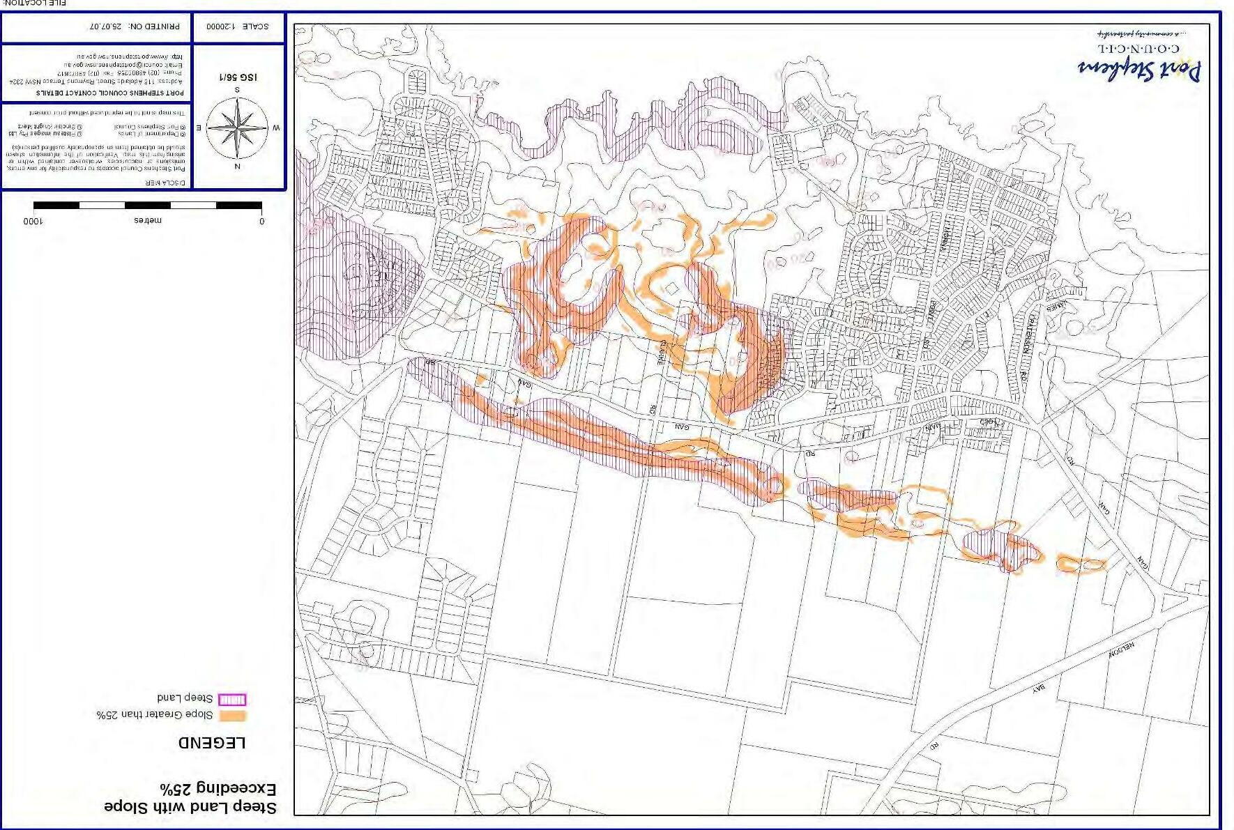
AnnaBayStrategyandTownPlan Figure 12 Steep Land 24
