Fern Bay and North Stockton Strategy

PORTSTEPHENS.NSW.GOV.AU | NEWCASTLE.NSW.GOV.AU
Acknowledgement
Port Stephens Council and City of Newcastle acknowledges the Worimi People as traditional custodians of this land and pays its respects to Worimi Elders, past, present and future.
Revision History
Revision Date Detail
Council Resolution CN PSC
1 28 May 2019 Draft Strategy (Version 1) N/A N/A
2 22 October 2019 Draft Strategy (Version 2) 76 197
3 24 March 2020 Final Strategy 14 N/A
4 14 April 2020 Final Strategy N/A 50
Abbreviations
CN City of Newcastle
DCP Development Control Plan
DHA Defence Housing Australia
EPA Environment Protection Authority
GNMP Greater Newcastle Metropolitan Plan 2036
HRP Hunter Regional Plan 2036
LEP Local Environmental Plan
LGA Local Government Area
NLEP Newcastle Local Environmental Plan 2012
NPWS National Parks andWildlife Services
PFAS Per and Poly Fluoroalkyl Substances
PSC Port Stephens Council
PSLEP Port Stephens Local Environmental Plan 2013
RAAF Royal Australian Air Force
Definitions
Town centre Shopping and business centre for the district, located in North Stockton. Includes health and professional services mixed with tourist accommodation and medium and higher density residential development
Neighbourhood centre A small scale commercial centre, located in Fern Bay, comprising limited retail development, including a neighbourhood supermarket to serve the day to day needs of the people who live or work in the local area. The neighbourhood centre is limited in area so as to not undermine the viability of the future town centre.
List of Figures
Figure 1 Strategy Area
Figure 2 Land use precincts
Figure 3 Monitoring, reporting and review cycle
Figure 4 Regional context map
Figure 5 Overall Structure Plan
Figure 6 Precinct 1: North Stockton
Figure 7 Precinct 2: Original Fern Bay
Figure 8 Precinct 3: Beachfront
Figure 9 Precinct 4: Sports
Figure 10 Precinct 5: Seaside Estate
Figure 11 Precinct 6: Fullerton Cove
Fern Bay and North Stockton Strategy
1
Executive Summary 3
Part A Introduction 6
Part B Goals 13
Part C Planning Principles.........................................................................................................20
Part D Precinct Plans 24
Attachment 1 Implementation Plan
Attachment 2 Background Investigations
2
Fern Bay and North Stockton Strategy
Contents
Executive Summary
Port Stephens Council and City of Newcastle have developed the Fern Bay and North Stockton Strategy (the Strategy) to guide future development and ensure sufficient community infrastructure is provided for the growing community The Strategy is based on evidence utilising information gathered from technical studies and investigations
The Strategyseeks to identify opportunities for Fern Bay and North Stockton to create a pedestrian focused place which offers housing diversity, a mixed use town centre, connected open spaces and community facilities
To achieve this vision the Strategy is guided by the following goals (Part B):
1 Environment: protect the treasured and unique Stockton Bight for future generations and attract responsible heritage and nature based tourism.
2 Town Centre: establish a conveniently located mixed-use town centre connected by technology, transport, housing, tourism and great public places
3 Housing: grow a resilient coastal community with access to liveable and diverse housing.
4 Open Space and Community Facilities: improve access to useable open spaces and well-designed community facilities to support daily activity and healthy lifestyles
5 Transport: prioritise safe and convenient travel by walking, cycling and use of public transport and duplicate Nelson Bay Road for its full length from Stockton to Newcastle Airport to support regional journeys.
6 Tourism: advocate for tourist and visitor accommodation to support the regional visitor economy and Newcastle Airport
The Strategy sets out planning principles (Part C) for each goal to guide future development, including the preparation and assessment of planning proposals to amend the relevant Local Environmental Plan (LEP).
Implementation of the Strategy is driven through identification of specific outcomes (Part D) for the six precincts that make up the Strategy Area: North Stockton, Original Fern Bay, Beachfront, Sports, Seaside Estate and Fullerton Cove (Figure 2). The actions are allocated a colour coded number. The colour aligns the action to the specific precinct goal.
Future development is likely to occur in the North Stockton and Beachfront precincts through redevelopment of larger, already disturbed sites. Development further north (of Fern Bay) is limited due to a range of environmental factors.
Fern Bay and North Stockton are well connected to the Newcastle City Centre, Newcastle Airport and Port Stephens. The Strategy seeks to provide housing options which are close to employment opportunities, as well as increase the opportunities for attracting visitorstothe area, building uponthe rich culture and raw beauty of Stockton Bight
Fern Bay and North Stockton Strategy
3
Figure 1 Strategy Area

4
Fern Bay and North Stockton Strategy
Part A Introduction


Introduction
A1 Purpose
Fern Bay has experienced rapid population growth over the last 15 years. In this time, the area has developed from a small village to a larger community incorporating a number of large, disconnected residential developments This has resulted in the creation of an urban population where a semi rural village centre had been
Port Stephens Council (PSC) and City of Newcastle (CN) have received planning proposals for the redevelopment of the Rifle Range and Fort Wallace sites, proposing up to approximately 400 additional dwellings within the Strategy Area The Fort Wallace planning proposal was gazetted on 13 September 2019. The Rifle Range planning proposal received a Gateway determination on 25 November 2019. These additional residents are expected to increase demand for essential community services and transport infrastructure. The redevelopment of large land holdings within North Stockton and South of Fern Bay have the potential to create positive outcomes and infrastructure for the community PSC and CN have identified the need to develop this Strategy to guide development in Fern Bayand NorthStockton for the next 20 years
A2 Structure of the Strategy
Part A provides context for the Strategy
Part B provides an overview of the goals for the area as informed by community aspirations.
Part C lists principles to inform future planning when land is rezoned
Part D details the outcomes for each of the six precincts in the Strategy Area with specific actions to achieve the goals.
A3 Application and Effect
The Strategy Area includes land within the Port Stephens (Fern Bay and Fullerton Cove) and City of Newcastle (North Stockton) local government areas (LGAs) (Figure 1). The Strategy does not include the established Stockton neighbourhood, southof CorrobaOval ormost parts of theFullerton
Fern Bay and North Stockton Strategy
Cove locality due to a range of known environmental constraints limiting development potential
Amendments to relevant Local Environmental Plans (LEPs), Development Control Plans (DCPs) and Local Infrastructure Plans will be required to implement the Strategy Planning proposals within the Strategy Area are to demonstrate consistency with the planning principles (Part C) and achieving the goals of the Strategy (Part B)
A4 Precincts
Six precincts (Figure 2) have been identified within the Strategy Area:
North Stockton includes the Stockton Residentail Centre (a residential care facility, which opened in 1900 and important in the Hunter region’s history for its role as a quarantine station and use as a mental health facility) and Fort Wallace (built for the defence of Newcastle during World War One) immediately to its south. Both sites have significant heritage value.
Original Fern Bay includes the original village boundary for Fern Bay, providing single detached dwellings within a grid street pattern. Palm Lakes Resort and Bayway Village are located to the north of the precinct and consist of manufactured dwellings for people aged over 50. Newcastle Golf Course is a significant land holding with opportunities for future development.
Beachfront comprises the greatest area of environmentally significant land, being Worimi Conservation Lands (WCL) and Stockton Beach. While no recent development has occurred within this precinct, the Rifle Range offers opportunities forfuture urban development and connectiontothe surrounding environmental lands
Sports precinct includes Corroba Oval and surrounding recreational land. The precinct will provide a common place for recreation and community activities for the Stockton Peninsula.
Seaside Estate is a planned community located within proximity to Stockton Beach and WCL. It consists mostly of single dwellings and some landscaped recreation areas
6
Part A
Fullerton Cove includes the only rural lands in the Strategy Area. The Cove Village, located in the south of the precinct, provides housing for over 55s with resort style facilities. Rural dwellings and agricultural land use are dispersed through the
northern section of the precinct. The precinct has the ability to accommodate a neighbourhood centre, providing for the day to day needs of the community.
7
Fern Bay and North Stockton Strategy
Figure 2 Land use precincts

8
Fern Bay and North Stockton Strategy
A5 Monitoring and Review
CN and PSC will monitor and review the Strategy
An annual report to each respective council on the implementation of its outcomes will be provided. The Strategy will be reviewed every five years, or as necessary.
areas reflect the aspirations derived from the community during the consultation. The community aspirations also act as strategic directions for planning and decision making that will help achieve the goals for each focus area
The Strategy was exhibited in October/November 2019. Key changes to the Strategy include the consideration of a neighbourhood centre within the Strategy Area, the inclusion of the Newcastle Golf Course as a Key Site and updating information.
A7 Regional context
Fern Bay and North Stockton are well positioned within the region (Figure 4) to capitalise on the vision projected by the NSW Government in the Greater Newcastle Metropolitan Plan 2036 (2018)
Figure 3 Monitoring, reporting and review cycle

Partnerships
CN and PSC have worked collaboratively to develop the Strategy with early input sought from the community and relevant organisations to plan for coordinated and sustainable growth
The two Councils are unable to deliver this Plan alone and will require cooperation and assistance across Government, industry and the community
Further engagement will occur throughout this process. Roles for each council, State agencies and other organisations have been clearly outlined in the Implementation Plan (Attachment 1) to ensure that the goals of the Strategy are realised.
A6 Community Engagement
The Strategy has beenguided by community input via comments received on an interactive online map, community survey and two separate drop-in sessions in September 2017.
The themes identified as priorities are Environment; Housing and People; Town Centre; Open Space and Community Facilities; Transport and Tourism. The goals for each of these focus
Fern Bay and North Stockton Strategy
The Strategy Area is situated on the main thoroughfare between Newcastle City and Newcastle Airport. TheAirport and Newcastle Port are considered 'Global Gateways' that offer employment opportunities next to Fern Bay and North Stockton. The Strategy Area's proximity to these regional assets in addition to the lifestyle and visitor opportunities offered in Fern Bay and North Stockton demonstrate the potential to positively contribute to Greater Newcastle.
9
Regional context map

10 Figure 4 –
Fern Bay and North Stockton Strategy
Hunter Regional Plan 2036 (2016)
The Strategy is aligned with and will contribute to achieving key goals of the Hunter Regional Plan 2036:


Goal 1 'The leading regional economy in Australia' by promoting new small business with the establishment of a new mixed use town centre (Direction 8) and growing tourism in the region at both Fern Bay and Stockton (Direction 9). The Strategy also supports the establishment of the DAREZ lands by providing additional housing within a 30 minute drive of the Airport/RAAF Base (Direction 7).
Goal 2 'A biodiversity rich natural environment' by protecting natural areas, including Worimi Conservation Lands and Hunter Wetlands, (Direction 14) and considering natural hazards and climate change for future residential areas (Direction 16)
Goal 3 'Thriving communities' by enhancing walking and cycling opportunities through identifying appropriate and accessible spaces and facilities (Direction 17 & 18) and protecting natural, built and cultural heritage (Direction 19). The design of a new mixed use town centre is to incorporate place-making principles (Direction 20).
Goal 4 'Greater housing choice and jobs' by establishing a compact settlement surrounding a new mixed use town centre and limiting further development on the urban fringe (Direction 21) and promote a mix of housing choices in new and existing residential areas (Direction 20).
11 A8 Planning Context
Fern Bay and North Stockton Strategy
Greater Newcastle Metropolitan Plan 2036 (2018)
The Strategy is aligned with and will contribute to achieving key outcomes of the Greater Newcastle Metropolitan Plan 2036:
Outcome 1 'Create a workforce skilled and ready for the new economy' by providing housing close to the airport and aerospace and defence precinct (Strategy 2) and increase tourism opportunities (Strategy 6)
Outcome 2 'Enhance environment, amenity and resilience for quality of life' by creating great public places where the community can come together (Strategies 10 and 11) and consider natural hazards and climate change for future residential areas (Strategy 14).
Outcome 3 'Deliver housing close to jobs and services' by increasing housing diversity and choice (Strategy 16)
Outcome 4 'Improve connections to jobs, services and recreation' by integrating land use and transport planning (Strategy 20).
The GNMP also requires CN and PSC to work together to coordinate housing and infrastructure development in Fern Bay to protect transport connections between the Newcastle Airport and Newcastle Port. It also requires focus on development of tourism opportunities in Stockton to support the establishment of a cruise ship terminal in the Carrington Precinct.
Newcastle 2030 CSP (2018) and Port Stephens CSP (2018)
The Strategy is aligned with the Newcastle 2030 and Port Stephens Community Strategic Plans, which outline the community's agreed aspirations and needs for the respective LGAs
Newcastle Local Planning Strategy (2015)
Stockton’s existing town centre, located in Mitchell Street, is a ‘Local centre (minor)’ that should be promoted as a tourism destination without reducing its appeal as a place to reside.
Identifies the consideration of a new commercial centre in North Stockton and the need to consider coastal erosion. The Strategy identifies an opportunity for a new town centre at North Stockton to service residents outside the existing Stockton Local Centre pedestrian catchment.
Port Stephens Planning Strategy (2011)
Fern Bay is a ‘Smaller Village Centre’ within the Eastern Growth Corridor of Port Stephens. Opportunities exist for increasing densities to maximise access to existing infrastructure and additional commercial zoned land is required. There are opportunities for infill (42) and greenfield (1,396) residential dwellings with an estimated density of 10 12 dwellings per hectare.
Planning proposals and key sites
Rifle Range
Fort Wallace
Seaside Estate
Stockton Residential Centre
42 Fullerton Cove Road
Newcastle Golf Course
Fern Bay and North Stockton Strategy
12
Part B Goals


Environment


GOAL
Community Aspirations and Strategic Directions
Protect the treasured and unique Stockton Bight for future generations and attract responsible heritage and nature-based tourism
Embrace the value of the Worimi Conservation Lands as a regional asset to benefit the local community
Understand coastal processes and identify management options for these processes
Focus development in areas that are less constrained and already disturbed
Protect environmental land to support the Watagan to Stockton Biodiversity Corridor
Promote local heritage and the traditional Aboriginal custodianship of the land
14
Fern Bay and North Stockton Strategy
Town Centre
GOAL
Community Aspirations and Strategic Directions


Establish a conveniently located mixed-use town centre connected by technology, transport, housing, tourism and great public places
Provide a new mixed-use town centre including a large format supermarket and complementary retail uses
Provide public spaces and a residential population surrounding the mixed use town centre
Support the existing commercial centre at Stockton to increase its viability
Allow a neighbourhood centre with a neighbourhood supermarket to service the day to day needs of the residents.
Leverage from natural surroundings to increase visitors
Locate the mixed use town centre in a central location with exposure to Nelson Bay Road to support opportunities for increased walkability
15
Fern Bay and North Stockton Strategy
Housing


GOAL
Community Aspirations and Strategic Directions
Grow a resilient coastal community with access to liveable and diverse housing
Provide diverse housing to support growth
Provide housing in areas well connected to public transport links for greater access
Increase housing densities within a walkable catchment to the mixed-use town centre
Limit housing growth on the urban fringe, particularly north of the Strategy Area
16
Fern Bay and North Stockton Strategy
Open Space and Community Facilities
Provide new community facilities with the mixed-use town centre
Maximise existing open space areas
Ensure new open space areas respond to community needs
Establish a district grade sports precinct at Corroba Oval
Improve access to useable open spaces and well-designed community facilities to support daily activity and healthy lifestyles Community Aspirations
Provide library and other services to support the community

17
Fern Bay and North Stockton Strategy
and Strategic Directions GOAL
Transport


Prioritise safe and convenient travel by walking, cycling, and use of public transport and duplicate Nelson Bay Road for its full length from Stockton to Newcastle Airport to support regional journeys

18
Fern Bay and North Stockton Strategy
Safely
homes
Promote walking and cycling as part of everyday life Investigate a ferry terminal at
Increase opportunities for public transport use by providing high quality bus stops Duplicate Nelson Bay Road as a regional transport corridor Community Aspirations and Strategic Directions
connect people from
to the mixed-use town centre and open space areas with foot and cycle paths
North Stockton
GOAL
Tourism


19
Fern Bay and North Stockton Strategy
tourist and vistor accommodation in the new mixed-use town centre
Community
and Strategic Directions
hotel and other tourist and visitor accommodation along
Road
uses that support tourism and tourism support facilities
the area’s tourism potential with connections to
and the
Advocate for tourist and visitor accommodation to support the regional visitor economy and Newcastle Airport Encourage
GOAL
Aspirations
Consider
Nelson Bay
Consider land
Recognise
Newcastle City, Newcastle Airport
Tomaree Peninsula
Part C Planning Principles


This Part provides the principles for development within the Strategy Area A planning proposal within the Strategy Area is to demonstrate how it is consistent with the principles and how it contributes to achieving each of the listed goals.
C1 Environment
Goal: Protect the treasured and unique Stockton Bight for future generations and attract responsible heritage and nature based tourism
Principles
1. Grow tourism in the region
Encourage visitors to experience the history and natural beauty of the area and promote tourism support services such as cafes, restaurants and short term accommodation.
2. Protect the coast and increase resilience to natural hazards
Consider the Newcastle Coastal Zone Management Plan 2018 and requirements of the future Coastal Management Program under the Coastal Management Act 2016
3. Protectimportantenvironmental assets and enhance biodiversity connections Protect the Watagan to Stockton Link Biodiversity Corridor including WCL and other areas of environmental significance
4. Recognise and conserve heritage
Ensure the indigenous and non indigenous significance of the area is reflected in the built environment through design, colours and materials.
1. Atraditional patternofcomplete streets and public spaces
Identifya distinct town centre incorporating a public domain that enables engagement and interaction of people
Provide a legible layout, with appropriate “landmarks” and adequate signage.
Develop policies that promote high quality, creative design of development, urban spaces and landscape settings.
Provide a variety of public spaces that are useable and pleasant to reflect community needs, including those for quiet reflection, noisy activities, public events and casual meetings
2. Pedestrian priority and integrated public transport
Provide a compact retail core and street network to encourage low vehicle speeds, use of public transport, walking and cycling, including commuter cycling and links to the beach.
3. Balanced and discrete parking provision
Provide convenient car parking for shoppers at a level of provision that will encourage the use of public transport but not disadvantage retailers in competition with other town centres.
C3 Housing Goal: Grow a resilient coastal community with access to liveable and diverse housing Principles
C2
Town Centre
Goal: Establish a centrally located mixeduse town centre in North Stockton that is connected by technology, transport, housing, tourist and visitor accommodation and great public places
Principles
Bay and North Stockton Strategy
1. Focus housing growth in locations that maximise infrastructure and services
Encourage higher density residential development in the town centre, near public transport stops, parks and other public open spaces.
2. Deliver greater housing supply and choice to encourage more affordable housing
Provide housing that is diverse in form, number of bedrooms, configuration and is
21
Fern
universally designed1 to cater for aging in place.
Provide aged care accommodation colocated with the mixed use town centre to provide older residents easier access to services and transport.
3. Limit urban sprawl and impacts on the natural environment Promote housing development within the existing urban footprint and provide highest residential densities in proximity to the town centre
C5
resources and expanded learning opportunities.
Transport
Goal: Prioritise safe and convenient travel by walking, cycling and use of public transport and duplicate Nelson Bay Road for its full length from Stockton to Newcastle Airport to support regional journeys
Principles
C4
Open Space and Community Facilities
Goal: Improve access to useable open spaces and well-designed community facilities to support daily activity and healthy lifestyles
Principles
1. Optimise access
Improve connections between residential and community areas and provide multipurpose, safe and innovative spaces that are equitably distributed across the local government areas
2. Connect with nature and culture Utilise the existing natural setting and cultural values to design an integrated open space network
3. Maximise user experience Encourange social connections and community participation and promote health and wellbeing. The development of a new library would facilitate the engagement of local residents with digital resources and expanded learning opportunities.
travel
4. Engage with new technology The development of a new library will assist local residents to access digital
1 universal design is the design and composition of an environment (e.g. building) so that it can be accessed, understood and used to the greatest
Fern Bay and North Stockton Strategy
1. Prioritise pedestrians and cyclists Link footpaths/sharedpaths fromhomesto the town centre, public spaces, and transport nodes including bus stops and ferry terminal(s)
2. Support public transport ridership Provide high quality transit stops (shelter, seating, signage, information and lighting) forming part of the transport network enabling convenient and safe access within and from the Strategy Area.
3. Maintain the integrity of Nelson Bay Road as a regional transport corridor Limit of one signalised intersection on Nelson Bay Road. Promote walking and cycling. Duplicate Nelson Bay Road to two lanes of travel in each direction from Stockton to Newcastle Airport and allow a share path, bus and access lanes Note: Transport for NSW are the authority for Nelson Bay Road and will be responsible for the design and construction of the road
C6 Tourism
Goal: Advocate for tourist and visitor accommodation to support the regional vistor economy and Newcastle airport
extent possible by all people regardless of their age, size, ability or disability (Source: National Disability Authority, 2012).
22
Principle
1. Encourage tourist and visitor accommodation in the new town centre Allow land uses to support tourism and tourism support facilities, hotel or tourist and visitor accommodation along Nelson Bay Road and in the mixed-use Town Centre.
Bay and North Stockton Strategy
Fern
23
Part D Precinct Plans

This Part provides the outcomes for each precinct that will be implemented through the Implementation Plan (Attachment 1).
Figure 5 Overall Structure Plan
Environment Outcomes
Investigate a Tomaree to Stockton walk (involving boardwalk/trails and observation decks) to link with the Great North Walk.
Investigate the establishment of formal walking trails (including directional, educational and interpretational signage) to link Seaside Estate and the Rifle Range site with the WCL and existing beach access.
Town Centre Outcomes
Implementation of the Stockton Public Domain Plan and Traffic Plan. Review residential uses (particularly single dwellings) that are permissible within the B2 Local Centre Zone of NLEP in the existing Stockton centre.
Further explore place making options and events to better activate spaces and assist in overall revitalisation of the existing Stockton centre.
Allow for the consideration of a neighbourhood centre, with a neighbourhood supermarket, in Fern Bay. The centre should be limited in area to be consistent with the Strategy’s objective to provide a mixed-use town centre in a central location with exposure to Nelson Bay Road
Open Space and Community Facilities Outcomes
Investigate future ownership of the beachfront land within the Strategy Area to enable continuous public access to the beach from Stockton to the WCL.
Investigate feasibility of a new modern library and multipurpose facility to be located within the proposed mixed use town centre.
Transport Outcomes
Provide a shared path from Seaside Boulevard, along the access trail to the east of Newcastle Golf Club, through to Popplewell Road then link up with the existing shared path to the east of Nelson Bay Road. This could also include a link to the rear of Bayway Village.
Indicative shared path providing a link between future development of the Rifle Range, potential mixed-use town centre and Fort Wallace sites. The location of this path would be determined pending detailed design of these developments.
A future road link should be provided connecting the existing Fern Bay residential area through to North Stockton (Fullerton Street). The road would pass through the Rifle Range, the potential mixed-use town centre and Fort Wallace sites. Ensure relevant site specific DCP sections allow for a road link connecting the three sites.
Relocate, upgrade or construct bus stops in accordance with the Seca Traffic and Transport Study.
Duplicate Nelson Bay Road to two lanes of travel in each direction between Vardon Road and Seaside Boulevard and allow a share path, bus and access lanes and two vehicle lanes in both directions Note: Transport for NSW are the authority for Nelson Bay Road and will be responsible for the design and construction of the road.
Fern Bay and North Stockton Strategy
25
Tourism Outcomes
Consider land uses to support tourism and tourism support facilities, hotel or tourist and visitor accommodation along Nelson Bay Road.
Bay and North Stockton Strategy
26
Fern

27
Fern Bay and North Stockton Strategy
Figure
Precinct 1: North Stockton
Environment Outcomes
Recommend that Fort Wallace is included on the State Heritage Register.
Review public access points to the northern parts of Stockton Beach to enhance accessibility, considering the impact on coastal erosion.
Investigate a potential source of sand for beach nourishment in Stockton area.
Town Centre Outcomes
Preferred Option: Liaise with the land owner to discuss future use of site. The site remains operational and no decision has been made by the State Government regarding the future use of the site. A masterplan to outline how the site can be redeveloped into the future is required to support any future change in land use. The masterplan process is to consider (but is not limited to) connections to adjacent sites, access to Stockton Beach, heritage and environmental opportunities, dwelling type and yield (including provision of affordable housing), location of mixed use town centre incorporating commercial, residential, tourist and visitor accommodation, open space and community uses.
Housing Outcomes
Provide housing incorporated with a mixed use town centre comprising residential (low medium density) accommodation, commercial, community and recreation uses. Note, the envisaged potential land uses would allow the existing uses on the site to continue.
Fort Wallace the planning proposal was gazetted on 13 September 2019. The land has been rezoned and requires a development application to be approved in order for the site to be developed.
Transport Outcomes
Upgradethe existing busstop onthe eastern sideof Fullerton Street, adjacent totheFortWallace access, to provide seating and shelter.
Remove the signage for the bus stop to the immediate north of the Stockton Bridge. Upgrade the existing bus stop on the western side of Nelson Bay Road, adjacent to the Stockton Cemetery access, to provide seating and shelter. This would be developed in conjunction with a pedestrian refuge to be provided in this location.
Provide a bus stop with seating and shelter along the western side of Fullerton Street, opposite the access to the potential future mixed use town centre. Encouraging safe crossing of Fullerton Street at the existing pedestrian crossing in this location.
Review the operation of the roundabout intersection at Nelson Bay Road / Fullerton Street prior to planning for the North Stockton Precinct which may not be required if the predicted level of background growth or future development is not realised.
Investigate a ferry terminal at North Stockton to support growth in the longer term. An existing boat ramp at North Stockton (south of Corroba Oval) has recently been upgraded. This opportunity could be further investigated in the future
Tourism Outcomes
Encourage tourism and visitor accommodation in the mixed use town centre
Draft
28
Fern Bay and North Stockton Strategy
6

29
Fern Bay and North Stockton Strategy
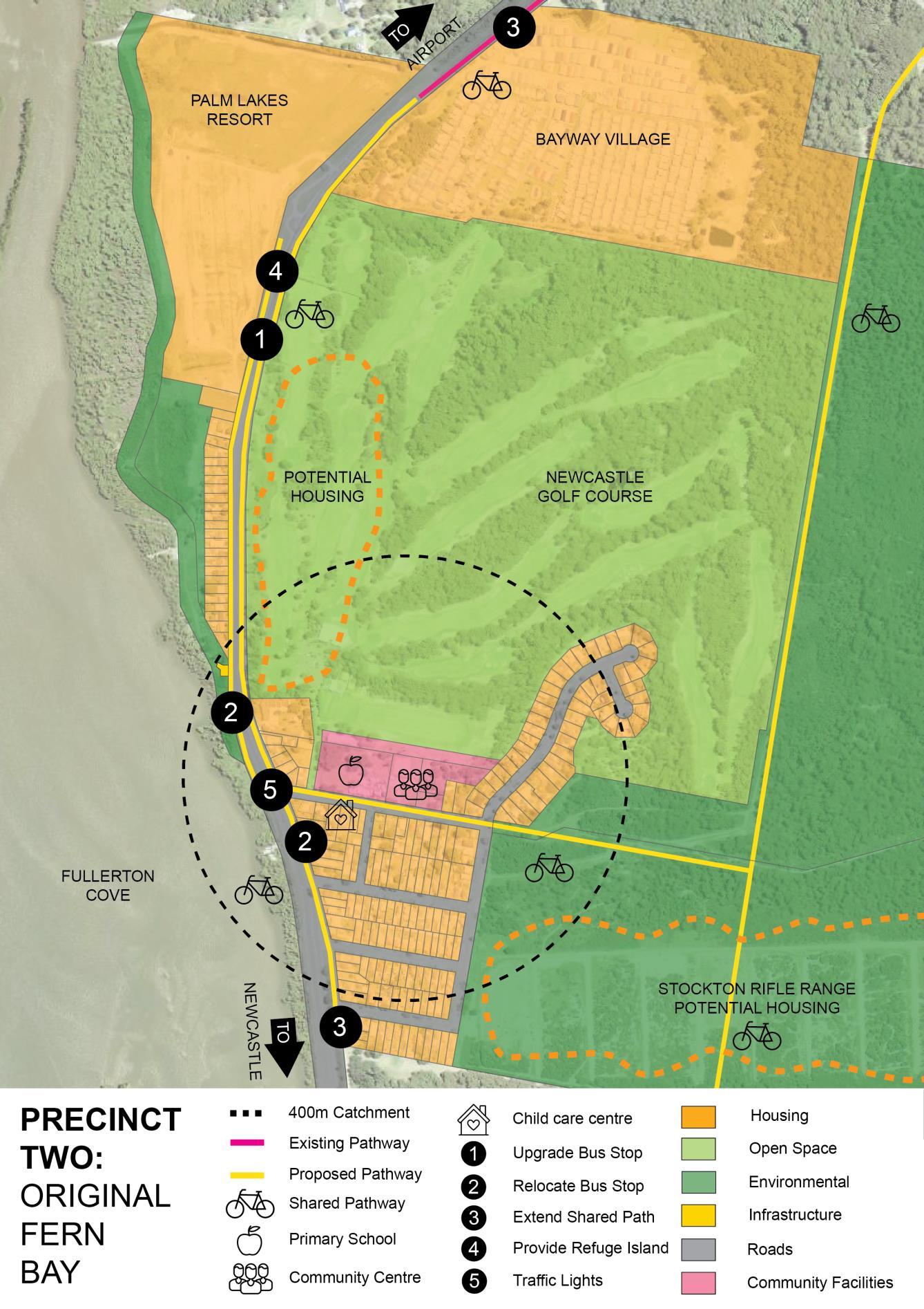
Figure 7 Precinct 2: Original Fern Bay
Town Centre Outcomes
Liaise with landowner to discuss potential future use of the site The masterplan process is to consider (but is not limited to) connections to adjacent sites, access to WCL, heritage and environmental opportunities, dwelling type and yield, tourist and visitor accommodation, open space and community uses.
Housing Outcomes
Provide housing with greater densities closer to the proposed mixed use town centre.
Undertake feasibility modelling to identify incentives or necessary amendments to planning controls to encourage infill housing development in Original Fern Bay.
Consult with the NSW Department of Education on potential growth scenarios and the provision of educational facilities and advocate for the provision of preschools.
Transport Outcomes
Upgrade the existing bus stop on the western side of Nelson Bay Road, adjacent to the Palm Lakes Resort access, to provide seating and shelter.
Relocate the existing bus stop on the eastern side of Nelson Bay Road, north of Vardon Road, to the south of Vardon Road. This relocation will allow for sufficient area to provide a bus stop with seating and shelter located in close proximity to the future signalised intersection of Nelson Bay Road and Vardon Road allowing for pedestrian phases on the signals.
Provide a bus stop with seating and shelter along the western side of Nelson Bay Road, to the north of Vardon Road, to encourage safe crossing at the future signalised intersection.
Upgrade the existing footpath along the eastern side of Nelson Bay Road, between Bayway Village and Braid Road, to provide a shared path along the length of Nelson Bay Road through the locality.
Extend the existing footpath, along the frontage of the residential developments on the western side of Nelson Bay Road, to the south to Vardon Road providing connection for pedestrians to cross safely at the future signalised intersection of Nelson Bay Road and Vardon Road.
Provide a suitably located refuge island at Nelson Bay Road near Palm Lakes / Bayway Village. Construct traffic signals and pedestrian crossing at the intersection of Vardon Road and Nelson Bay in conjunction with the Rifle Range Planning Proposal to allow the safe crossing of Nelson Bay Road for pedestrians and enable safe vehicular access onto Nelson Bay Road.
Tourism Outcomes
Landuses along Nelson Bay Road to consider hotel or tourist and visitor accommodation.
Bay and North Stockton Strategy
30
Fern
31
Fern Bay and North Stockton Strategy
Figure 8 Precinct 3: Beachfront
Environment Outcomes
Review the heritage significance of the Rifle Range site through consideration of a planning proposal.
Housing Outcomes
Undertake a detailed assessment of the 'Request to Amend the Port Stephens Local Environmental Plan' submitted by DHA for the Rifle Range site, which received a Gateway determination on 25 November 2019.
Support the proposed town centre by providing medium density housing within walkable distances
Open Space and Community Facilities Outcomes
Investigate options for improved continuous public access to the beach from Stockton to the WCL
Transport Outcomes
Provide an internal bus stop as part of the future development of the Rifle Range Site. Consideration should be given to providing bus services throughthe existing Fern Bay residential area, to service houses adjacent Rifle Range site.
Figure 8 Precinct 4: Sports Open Space and Community Facilities Outcomes
Investigate a new Sporting Precinct at Corroba Oval including multipurpose courts, additional playing fields, parking, amenities building and undercover seating.
Transport Outcomes
Consider constructing a pedestrian refuge island on Fullerton Street to ensure safe pedestrian access to Corroba Oval.
Request Transport for NSW to review the 70km/hr speed limit on Fullerton Street and consider a reduction to 50km/hr.
Consider cycling facilities (including electric) at the proposed Sporting Precinct at Corroba Oval or the mixed use town centre and Stockton Ferry terminal.
Advocate to Transport NSW for a new ferry terminal at North Stockton. A potential location is the existing boat ramp that has recently been upgraded.
Fern Bay and North Stockton Strategy
32


33
Fern Bay and North Stockton Strategy
Figure 9 Precinct 5: Seaside Estate
Town Centre Outcomes
Undertake a detailed assessment of the 'Request to Amend the Port Stephens Local Environmental Plan' submitted for 2, 4, 4A, 4B, 5, 20, 21, 22, 23, 24 ,25 and 26 Seaside Boulevard, Fern Bay.
Open Space and Community Facilities Outcomes
Continue investigations to improve recreational and community facilities at Seaside Estate, including public toilets within the development.
Transport Outcomes
Relocate and upgrade (seating and shelter) the existing Seaside Estate bus stop in consultation with the community, Transport for NSW and bus companies to provide greater connectivity for local residents.
Figure 10 Precinct 6: Fullerton Cove
Environment Outcomes
Consider rezoning land mapped as containing an endangered ecological community to an environmental zone.
Town Centre Outcomes
Undertake a detailed assessment of the 'Request to Amend the Port Stephens Local Environmental Plan' submitted for 42 Fullerton Cove Road, Fullerton Cove.
Transport
Outcomes
Provide seating and shelter on both sides of Fullerton Cove Road in the location of the existing bus zones.
Fern Bay and North Stockton Strategy
34


35
Fern Bay and North Stockton Strategy
Attachment 1 Implementation Plan
Key:
I S M L O
Immediate 0 2 years (2020 2022)
Short term 3 5 years (2023 2025)
Medium term 6 10 years (2026 2030)
Long term 11 20 years (2031 2040) Ongoing (continuous action and/or monitoring)
No Actionable Outcome Specific
What will be undertaken?
Overall
1 Investigate a Tomaree to Stockton walk (involving boardwalk/trails and observation decks) to link with the Great North Walk.
2 Investigate the establishment of formal walking trails (including directional, educational and interpretational signage) to link Seaside Estate and the Rifle Range site with the WCL and existing beach access.
3 For existing Stockton Town Centre: Implementation of the Stockton Public Domain Plan and Traffic Plan.
4 For existing Stockton Town Centre: Review residential uses (particularly single dwellings) that are permissible within the B2 Local Centre Zone of Newcastle Local Environmental Plan 2012.
5 For existing Stockton Town Centre: Further explore place making options and events to better activate spaces and assist in overall revitalisation of the existing centre.
6 Investigate options for improved continuous public access to the beach from North Stockton to theWCL.
Discussions with relevant stakeholders will be undertaken to plan for a connected trail.
7 Investigatefeasibilityofanewmodernlibraryand multipurpose facility to be located within the proposed mixed use town centre.
Ensure Planning Proposals or staging of existing residential developments include pedestrian access to conservation lands and the beach.
Discuss options with Seaside Estate residents/developer, NPWS and WCL Board of Management.
Staging and costing of the works, detailed design and implementation.
Further investigate removing single dwellings as apermissibleusewithintheB2LocalCentreZone inresponsetoactionscontainedwithinNewcastle Local Planning Strategy and the Hill PDA Commercial Study.
Consider more activities to celebrate Stockton's unique history, heritage and culture.
Undertake discussions concerning future ownership and management of beachfront land with key stakeholders, including landowners so the community can access the beach. Sites include Lot 5, DP 233358; Lot 430, DP 835921; and Lot 202, DP 1150470
A larger library is required to support the District Area (Fullerton Cove, Fern Bay and Stockton). Further planning and understanding around feasibility is required.
Implementation Plan: Fern Bay and North Stockton Strategy 1
Attachment 1 Implementation Plan
Measurable Assignable Realistic Timing
How will the action be measured as a success?
Funding and approval of a project plan to construct a Tomaree to StocktonWalk.
Who will implement the action?
Overall
NPWS, WCL Board of Management and Worimi LALC (landowners). PSC (Strategic Planning) & CN as advocates in conjunction with land owners and board.
What results can be achieved given resources?
The project would require multi agency cooperation and significant contributions from grant funding. Liaison with the State government is recommended.
Future planning proposals to identify how these will work.
Detailed costing and design for location and number of links finalised.
Implementation of the works outlined in the plan.
Finalise assessment as part of preparation of the Housing Strategy and Local Strategic Planning Statement and potential planning proposal.
Community feedback, activated spaces and a revitalised centre.
Improved public access to the beach between Stockton and WCL.
NPWS, WCL Board of Management and Worimi LALC and site landowners. PSC (Strategic Planning) to advocate and consider with any relevant rezoning.
CN
CN
Stockton Community in partnership with CN
CN, PSC (Strategic Planning + Community and Recreation Assets), NPWS, landowners and other key stakeholders.
Subject to working in collaboration with landowners and key stakeholders.
PSC does not own any landandthismayincrease complexity in delivering the projects.
Through work programs and already agreed upon funding. O
Through work programs and already agreed upon funding. S
Through work programs and place making grants. O
Through work programs. Investigation needs to understand ongoing maintenance and associated costs required.
Selection of preferred site and location ideally within an identified community hub or precinct, located within the proposed mixed use centre and better understanding of associated costs.
CN and PSC (Library Services)
Plan: Fern Bay and North Stockton Strategy
Preparation of a project brief can be done through work programs. A new library for Stockton is listed in the Development Contributions Plan. Funding and grants are also available to construct libraries.
S
2
Implementation
S
M
S
No Actionable Outcome
8 A future road link should be provided connecting the existing Fern Bay residential area through to NorthStockton(FullertonStreet).Theroad would pass through the Rifle Range, the potential mixed use town centre and FortWallace sites.
9 Construct footpaths and shared paths in accordance with the Seca Traffic and Transport Study.
10 Relocate, upgrade or construct bus stops in accordance with the Seca Traffic and Transport Study.
11 Advocatefor wideningofNelsonBayRoadtotwo lanes of travel in each direction plus bus and accesslanes betweenVardonRoadandSeaside Boulevard.
12 Prepare an amendment to the Strategic Asset Management Plan (SAMP) to align the infrastructure items outlined in this Strategy with the SAMP for each council.
13 Prepare an amendment to the relevant Local Infrastructure Contributions Plan to align the infrastructure items outlined in this Strategy
14 Consider infrastructure funding options in addition to the SAMP and Infrastructure Contribuions Plans.
Specific
EnsurerelevantsitespecificDCPSectionsallows for a road link connecting the three sites.
Four paths have been identified and prioritised in the Seca T&T Study. These paths will be designed, costed and included in the relevant SAMP.
Eleven bus stop locations have been identified and prioritised in the Seca T&T Study. These bus stopswillbedesigned,costedandincludedinthe relevant SAMP.
Provide a written submission to Transport for NSW detailing outcomes of the Seca T&T Study and need for upgrade and prioritise journeys to the Newcastle airport.
Each council will prepare separate amendments to their SAMP to ensure that the infrastructure identified in this Strategy can be delivered as the area grows
Each council will prepare separate amendments to their Infrastructure Contributions Plans to ensure that the infrastructure identified in this Strategy can be delivered as the area grows
Council’s often rely on grant funding, either wholly or partly, to deliver infrastructure projects. This action will be implemented by identifying other funding options, such as state and national grants, to deliver the infrastructure identified in this Strategy.
Precinct 1: North Stockton
15 Review public access points tothe northern parts of Stockton Beach to enhance accessibility, considering the impact on coastal erosion.
16 Investigate potential source of sand for beach nourishment in Stockton area.
Consolidation of access points to be considered through the preparation of the Stockton Coastal Management Plan.
Further explore with landowner and key stakeholders potential to use sand from north of FortWallace as a source of sand to replenish the southern end of Stockton.
Implementation Plan: Fern Bay and North Stockton Strategy
3
Measurable Assignable Realistic Timing
Council Adopted DCP's identifying the proposed link
Inclusion of proposed paths in relevant SAMP and Development Contributions Plans.
Inclusion of proposed paths in relevant SAMP and Development Contributions Plans.
CN and PSC (Strategic Planning + Civil Assets)
CN and PSC (Civil Assets)
Subject to landowners undertaking relevant proposals and liaison with Council.
Though works programs. Development Contributions funds may be utilised and grants should be considered following detailed design and costing.
S
CN and PSC (Civil Assets)
Constructionof road widening. Transport for NSW construction
CN and PSC written submission (Strategic Planning)
Though works programs. Development Contributions funds may be utilised and grants should be considered following detailed design and costing.
Transport for NSW are intending to develop a Strategywhichwillidentifyand prioritise upgrades along the corridor. Implementation of this action will be dependent on Transport for NSW.
S
The adoption of an amended SAMP for each council
CN and PSC (Civil Assets) The SAMP is updated every 12 months. Depending on the timing for adoption of this Strategy, the infrastructure items can be identified in a future amendment to the SAMP
S-M
I
I
The adoption of an amended Contributions Plan for each council
This action will be measured by the identification of potential grant funding schemes and the completion of grant applications for infrastructure item identified in this plan.
Public access points are constructed.
Monitoring through implementation of Plans.
Visualinspectionstoshow reduction of informal access points.
Investigation studies for sand sourcing completed.
CN and PSC (Strategic Planning) An amendment can be prepared to the existing Contributions Plans adapted by each council. This could occur followingadoptionof the Strategy
CN and PSC (Strategic Planning, Civil Assets + Community and Recreation Assets)
CN
Council often applies for grants to assist in delivering infrastructure projects. This action is realistic given the nature of infrastructure delivery through local government.
Precinct 1: North Stockton
CN will implement this action through respective work programs.
Funding sources may be available through grants or Development Contributions.
CN Investigations conducted as part of implementation of Newcastle Coastal Zone Management Plan and preparation of Coastal Management Program.
I
O
S-M
S
Implementation Plan: Fern Bay and North Stockton Strategy
4
No Actionable Outcome Specific
17 Preferred Option: Liaise with land owner to discuss future use of site. A masterplan to outline how the site can be redeveloped into the future is requiredtosupportanyfuturechangeinlanduse. The masterplan process is to consider matters identified in this Plan.
18 Establish a ferry terminal at North Stockton to support growth in the longer term.
Development of a masterplan consistent with the Fern Bay and North Stockton Strategic Plan, Local Environment Plan, Development Control Plan and other relevant legislation.
Advocate to Transport NSW for a new ferry terminal at North Stockton. A potential location is the existing boat ramp that has recently been upgraded.
Precinct 2: Original Fern Bay
19 Undertake feasibility modelling to identify incentives or necessary amendments to planning controls to encourage infill housing development in Original Fern Bay.
20 Consult with the NSW Department of Education onpotentialgrowthscenariosandtheprovisionof educational facilities and advocate for the provision of preschools.
21
ProvideasuitablylocatedrefugeislandatNelson Bay Road near Palm Lakes / Bayway Village.
22 Construct traffic signals and pedestrian crossing at the intersection of Vardon Road and Nelson Bay in conjunction with the Rifle Range Planning ProposaltoallowthesafecrossingofNelsonBay Road for pedestrians and enable safe vehicular access onto Nelson Bay Road.
Further investigate planning incentives to encourage infill housing in original Fern Bay by lasing with DPE.
Provide a joint written submission to NSW Department of Education on potential growth scenarios, the provision of educational facilities and consider the provision of preschools.
Liaise with Transport for NSW regarding relocating the refuge island.
Trafficsignalswillbelinkedtodevelopmentofthe Rifle Range site and subject to the development progressing.
Precinct 3: Beachfront
23 Review the heritage significance of the Rifle Range site through the assessment of the Request to Amend the Port Stephens Local Environmental Plan.
24 Proceed with planning proposal as per the Gateway determination (dated 25 November 2019) to allow part of the site to be zoned R3 Medium Density Residential.
Prepare Councils planning proposal to list the Rifle Range as a Heritage item (Part 1) in Schedule 5 of the PSLEP.
Proceed with LEP Amendment to allow around 300 dwellings the Rifle Range site.
Implementation Plan: Fern Bay and North Stockton Strategy
5
Measurable Assignable Realistic Timing
Completionofthemasterplan. Landowner in consultation with CN
Construction of a ferry terminal. Transport for NSW construction CN written submission
Through work programs. S
Need for the terminal is apparent form the overuse of the Stockton terminal and projected growth identified din this plan. Implementation will bedependentonTransportfor NSW
I
Precinct 2: Original Fern Bay PSC to review progress including reviewing DAs or CC's for infill development.
Discussion with NSW Department of Education and ongoing review of social infrastructure to support the North Stockton and Fern Bay community.
PSC (Strategic Planning) to liaise with DPE.
PSC & CN (Strategic Planning) written joint submission
Through work programs. M
Through works programs. I
Construction of refuge island. PSC (Civil Assets) / Transport for NSW
Construction of traffic signals. PSC (Strategic Planning) / landowner
Precinct 3: Beachfront
Needs to be identified in the SAMP and funding determined.
Identification of the item in Development Contributions Plan may be necessary.
S
M
An amendment to the LEP is gazetted 12 months following the Gateway Determination.
Completion of the detailed assessment, exhibition of the planning proposal and Gazettal of the LEP Amendment
PSC (Strategic Planning) The NSW Department of Planning and Environment identifies 12 months as a target timeframe for minor LEP amendments.
PSC (Strategic Planning) Through work programs. I
I
Implementation Plan: Fern Bay and North Stockton Strategy 6
No Actionable Outcome Specific
Precinct 4: Sports
25 Investigate a new Sporting Precinct at Corroba Oval including multipurpose courts, additional playing fields, parking, amenities building and undercover seating.
26 Consider constructing a pedestrian refuge island on Fullerton Street to ensure safe pedestrian access to Corroba Oval.
27 Request Transport for NSW to review the 70km/hr speed limit on Fullerton Street and considered a reduction to 50km/hr.
28
Prepare a report considering the potential upgrades needed to support the community and recommendations from the Stockton Coastal Zone Management Plan and Program.
Liaise with HWC as adjoining landowner.
Identify the refuge island in the SAMP.
Provide a written submission to Transport for NSW detailing outcomes of the Seca T&T Study and need for review.
Precinct 5: Seaside Estate
Undertakeadetailedassessmentofthe'Request toAmendthePortStephensLocalEnvironmental Plan' submitted for 2 Seaside Boulevarde, Fern Bay.
29 Continue investigations to improve recreational and community facilities at Seaside Estate.
30 Consult with the community and other stakeholders regarding the proposed relocation of the bus stop at Lots 4 and 5 DP 280073, 5B and 7 Seaside Boulvard.
Undertake a detailed assessment of the 'Request toAmendthePort StephensLocalEnvironmental Plan' submitted for Site 6.
Liaise with developer to better understand what facilities are proposed and when they will be constructed to support residents of the development.
Council will continue to liaise with the relevant stakeholders, including Transport for NSW, bus companies and the community to determine the most appropriate location for bus stops within Seaside Estate.
Precinct 6: Fullerton Cove
31 Consider rezoningland mapped as containing an endangered ecological community to an environmental zone.
32
Undertakeadetailedassessmentofthe'Request toAmendthePortStephensLocalEnvironmental Plan' submitted for 42 Fullerton Cove Road, Fullerton Cove.
Investigate preparing a planning proposal by liasing with DPIE, ESS and relevant Council staff to amend LEP.
Undertake a detailed assessment of the 'Request toAmendthePort StephensLocalEnvironmental Plan' submitted for Site 4.
Plan: Fern Bay and North Stockton Strategy
Implementation
7
Measurable Assignable Realistic Timing Precinct 4: Sports
Adoption of a masterplan for the site. CN
Report prepared initially may be included through works programs. Master planning of the site may require an external consultant (which may be funded by Development Contributions).
Construction of refuge island CN / Transport for NSW Needs to be identified in the SAMP and funding determined.
Review undertaken by Transport for NSW and response received.
Transport for NSW review CN written submission
S
S
Through works program. I
Precinct 5: Seaside Estate
Completion of the detailed assessment. PSC (Strategic Planning) Through work programs. I
Community feedback on appropriate facilities. PSC (Strategic Planning) to Through work programs. S
Community feedback on appropriate location. PSC (Strategic Planning, Community Development and Engagemnet, and Facilities and Services) to facilitate communication between relevant stakeholders.
Through work programs S Precinct 6: Fullerton Cove
Preparation of a planning proposal to amend the LEP. PSC (Strategic Planning) Through work programs S
Completion of the detailed assessment and preparation of a planning proposal.
PSC (Strategic Planning) Through work programs. I
Implementation Plan: Fern Bay and North Stockton Strategy
8
Attachment 2 Background Investigations
Attachment 2 provides an overview of the investigations that were carried out to inform the Planning Principles (Part C) and Precinct Plans (Part D).
List of Figures in Attachment
Figure 2A Existing land uses
Figure 2B Environmental considerations heat map
Figure 2C Potential town centre site
Figure 2D Strengths and opportunities SWOT Analysis: Stockton Local Centre
Figure 2E Images showing growth
Figure 2F Envisaged demographic
Figure 2G Anticipated dwellings
Figure 2H Expected growth
Figure 2I Envisaged housing types
Figure 2J Estimated growth
Figure 2K Standards for open space and facilities
Fugure 2L Location of community facilities and open space
Figure 2K Nelson Bay Road Future Cross Section
Figure 2A Existing land uses
Background Investigations: Fern Bay and North Stockton Strategy 1

B1 Environment
The Strategy Area has a diverse range of environmental attributes affecting land use patterns. The Heat Map (Figure 6) illustrates how land in the Strategy Area is affected by accumulative constraints. The Strategy Area is bound by the Hunter River and Stockton Beach which increases the likelihood of flooding and drainage issues. The following list includes some of the environmental considerations in the Strategy Area:
Coastal Zone and Wetlands
Drainage and Flooding
Endangered Ecological Communities
Heritage (Indigenous and Non Indigenous)
Ramsar (Hunter) Wetlands
Koala Habitat
Coastal Erosion
Stockton has the largest active dunes in coastal Australia and the Stockton Beach has a long history of erosion and recession. The dunes are un vegetated which allows sand to be blown into and northwards along the dunes and onto surrounding lands (BMT WBM, 2017). Past modelling has indicated that the breakwaters at the Hunter River entrance have interrupted the flow of sand from Nobbys north to Stockton Beach. Erosion continues to worsen resulting in a significant volume of sand being lost from Stockton Beach each year. Sand from further north along the dunes may offer a potential source of sand to replenish eroded beach. Hazard lines have been developed to assist with planning for growth.These hazard lines areunder review by CN.
Green Corridors
The Strategy Area is located within the Watagan to Stockton Link Biodiversity Corridor (identified by the HRP). Planning in this area aims to conserve existing remnant vegetation and invest in the rehabilitation of land to strengthen the regionally significant corridor. The viability of the corridor is influenced by current and future land
use demands in the area. The Strategy attempts to ensure lands of ecological significance are protected to support the corridor.
Worimi Conservation Lands
Worimi Conservation Lands (WCL) and Stockton Bight are distinctive features of the Port Stephens Local Government Area (LGA) connecting Nelson Bay to Stockton. The Bight includes 30km of beach and prominent sand dunes reaching up to 40m in height. The Stockton Bight provides a unique setting for outdoor recreation, education and cultural tourism.
The Plan of Management for WCL sets a vision to protect, respect and connect with Country. Considerable archaeological investigations and reporting of the lands has been undertaken with a number of sites (including middens, stone artefacts and bird, fish, animal bone and burial sites) identified as providing material evidence of theWorimi People's past use. The sites protected are “important to Aboriginal people for social, spiritual, historical, and commemorative reasons” (OEH, 2015).
There is limited pedestrian access to the WCL including the absence of a walking trail to Stockton Beach. While significant tourism opportunities are available at WCL, such as four wheel driving, horse riding and quad bike riding, these activities must be balanced with the efforts seeking to protect conservation lands including Aboriginal sites.
PFAS Contamination
TheWilliamtown RAAF Base PFAS Management Area Maps published by the EPA identify the North West portion of the Strategy Area as part of its Broader Management Zone. The EPA advises that the topography and hydrology of the area means PFAS detections could occur within the Broader Management Zone. Precautionary advice issued by the EPA for residents in the PFAS Management Area aims to discourage activities that would increase the likelihood of human exposure to PFAS chemicals originating from the Williamtown RAAF Base.
Investigations: Fern Bay and North Stockton Strategy
Background
2
Map disclaimer: The map focuses on identifying where development is not appropriate due to land suitability. The map is intended to give an overview of constrained land within the Strategy Area only and an indication of where future development should be located.
Figure 2B Environmental considerations heat map
Background Investigations: Fern Bay and North Stockton Strategy

3
B2 Town Centre
This section investigates the demand, potential locations and opportunity for a supermarket and supporting retail uses within the Strategy Area.
B2.1 Is there a need for a supermarket? Existing retail development in Fern Bay is limited to a takeaway food and drink shop on Nelson Bay Road. While the existing commercial centre at Stockton (7 10 minute drive from Strategy Area) offers a supermarket, residents have indicated that they are more likely to travel to Medowie, Newcastle and Mayfield for their main shop. These centres are approximately 20 minutes by car outside peak hours.
A recent study by Hill PDA found that there is sufficient demand in the Strategy Area to support a retail centre of approximately 6,285m2. The Hill PDA Study recommends: a new local centre of 4,000 6,500m2 (including a large format supermarket of 2,800 3,200m2 with complementary specialty floor space) within the Strategy Area; that the new centre could leverage from its natural surroundings to increase visitors; the resident population within the immediate vicinity of the new local centre should be increased; and there may be potential for a mixed use development (retail and residential) at the new centre given recent housing trends.
B2.2 Where should a supermarket be located?
The Hill PDA study examined 6 sites within the Strategy Area (Figure 7) and ranked the sites from 1 (Very Poor) to 5 (Very Strong) against several assessment criteria that included:
Developable Area: a centre 5,000 6,000m2 provided over one level with at grade parking would require approximately 2ha of developable land;
Location: a successful centre must be centrally located for convenient access by a majority of residents of which it serves;
Exposure: retail development benefits from being located in high profile locations such as main arterial roads; Accessibility: with people becoming increasingly ‘time poor’ convenience and accessibility increases the attractiveness and visitation of a centre; and Walkable Catchment: walkable communities bring significant economic and social benefits including reduced vehicle emissions and petrol costs, improved traffic safety and health benefits. A centre that has a higher residential population within 800m (10min walk) is likely to experience increased pedestrian activity and vitality.
The sites assessed are in single ownership and their developable area offers greater opportunity for major changes in land use than other sites.
There are two sites already zoned for commercial use within the Strategy Area including the take away food and drink shop (referred to in B2.1) and Site 6 (Figure 7). These sites were found not to be suitable for expanded commercial use as a town centre due to their size or location.
The site ranking process identified Site 1 (in North Stockton Precinct) and Site 2 (in Original Fern Bay Precinct) as the preferred locations for a town centre. Both sites are accessible to residents in the Strategy Area, have large developable areas and contain comparatively few environmental constraints. The town centre's location will be dependent on the intentions of landowners and willingness to accommodate development. Should a Planning Proposal be lodged for either site councils will consult with each other and the State Government in considering the proposal. A masterplan will be needed for either site to determine the appropriate scale, type and mix of development that could occur.
Investigations: Fern Bay and North Stockton Strategy
Background
4
Figure 2C Potential town centre sites

Background Investigations: Fern Bay and North Stockton Strategy

5
B2.3 Coexisting with the existing commercial centre at Stockton
The Hunter Regional Plan (DPE, 2016) identifies the importance of utilising existing centres for commercial and retail development to ensure that new centres: a. are integrated with existing or planned residential development; b. encompass high quality urban design; c. consider transport and access requirements; and d. do not undermine existing centres.
The Hill PDA study examined the existing commercial centre at Stockton and Figure 8 identifies its strengths and opportunities. Significantly, the existing commercial centre at Stockton is not conveniently located for residents in the north of the Strategy Area and does not meet the needs of current residents in Fern Bay.
The Hill PDA study does identify that a new retail centre may result in a moderately strong or significant impact on trade in the existing Stockton commercial centre, although this impact would lessen overtime with population growth and expenditure in the locality.
Despite the potential impact on the existing commercial centre in Stockton, it is recommended that a new mixed use town centre be supported to: meet the needs of the local (and future) residents in an area which is currently underserviced; reduce travel demand by providing an improved range of shops and services to reduce the number of journeys made by local residents to surrounding centres. This supports a reduction in vehicle emissions, improves transport safety and can contribute to lower cost of living; and increase employment opportunities in the area.
The existing commercial centre at Stockton will continue to provide an important role in supporting the residents and visitors of Stockton by providing a mix of retail and community uses. Although it is not located within the Strategy Area, there are several initiatives that may improve the performance of the Stockton commercial centre, these include:

Local eat street
Tourism
Increase the resident population surrounding the town centre.
Figure 2D Strengths and opportunities SWOT Analysis: Stockton Local Centre (Source: Hill PDA, 2017)
Background Investigations: Fern Bay and North Stockton Strategy
6
1998
community but also to ensure that further growth of the Strategy Area occurs in a coordinated way.
The current demographics for each precinct can be summarised as:
Precinct Demographics
North Stockton (307 persons at 1.8 persons/ha) Consisting mostly of residents from the care facility aged between 35 and 74 years of age.
Original Fern Bay (930 persons at 7.08 persons/ha outside Bayway Village and 729 persons at 27.25 persons/ha within Bayway Village) Has the most diverse mix of age groups of any precinct.
Beachfront (0 persons)
Sports (0 persons) Seaside Estate (1,111 persons at 5.17 persons/ha) Predominately young families with the highest number persons aged 0 14. Fullerton Cove (568 persons at 0.31 persons/ha) Predominately people aged over 65 due to The Cove Village. (Source: Remplan, 2018)

2015
Figure 2E Images showing growth
B3.1 How has the area grown?
From 2006 to 2016 Fern Bay's population doubled from 1,137 to 2,673 people. This growth has been facilitated by new developments such as the Seaside Estate, Palm Lakes Resort and The Cove Village.
Previously, PSC's vision for Fern Bay was a compact village confined to the existing urban footprint within the Original Fern Bay Precinct (PSC, 2002). The rapid increase in residential development in the area has resulted in development being out of step with the provision of infrastructure.

Fern Bay is a desirable place to live and visit, and is identified as part of the Eastern Growth Corridor (PSC, 2011). The Strategy not only attempts to identify the community infrastructure required to support the local
B3.2 What does the future population look like?

7 B3
Background Investigations: Fern Bay and North Stockton Strategy
Housing
Note: Assumes 100% of dwelling potential will be constructed. Site specific investigations required.
strategic centre (Newcastle Airport) and the following precincts are expected to accommodate housing growth.
Figure 2F Envisaged demographic (Source: Remplan, 2018)
Hill PDA (2017) provided forecasts for Fern Bay, Fullerton Cove and Stockton as part of the Commercial Lands Study. High growth scenario projections predict a population of up to 12,500 people.


It is expected that Stockton (not including North Stockton) will grow from 4,400 up to 5,000 people by 2036. This is consistent with projections forecast by profile.id which expect a population of 4,526 in Stockton by 2041 (profile.id, 2018).

B3.3 Where will future housing occur?
The HRP has set a target of 95% of people living within 30 minutes of a strategic centre. The Strategy Area is within 30 minutes of a

Note: Assumes approximately 750 dwellings can be accommodated with mixed use town centre.
Figure 2G Anticipated dwellings
Note: Assumes 100% of dwelling potential will be constructed. Site specific investigations required.
Figure 2H Expected growth (Source: Remplan, 2018)
Future housing within the Strategy Area will predominantly be focused on four key sites, within the North Stockton Precinct, Original Fern Bay Precinct and south of the Beachfront Precinct. Housing is to be integrated within and surrounding the mixed use town centre and adjoining properties. Figure 13 illustrates the diversity of housing that may be provided in thediffering precincts.Thegreatest diversity of housing will be provided in conjunction with the mixed use town centre. A challenge associated with 'aging in place' within the Strategy Area will be to provide adequate social support services to the community.
Background Investigations: Fern Bay and North Stockton Strategy
8
Figure 2I Envisaged housing types

Key Site: Town Centre
Potential Dwellings Subject to detailed site investigations
Existing Zone SP2 Infrastructure (Health Services Facility)
Potential Land Uses Mixed use town centre (commercial/residential), community and recreation uses. Potential zones and planning controls will be determined through the master planning process. The planning controls will be determined through the master planning process The envisaged potential land uses would allow the existing uses on the site to continue.
Key Site: Rifle Range
Potential Dwellings Approximately 300
Existing Zone E2 Environmental Conservation
Potential Land Uses Low / medium density residential and open space
A Gateway determination was issued for the Rifle Range Planning Proposal on 25 November 2019
The site is largely disturbed and is considered appropriate for residential development. The limited opportunity for growth in the Strategy Area reinforces the importance of housing at the Rifle Range. Vehicle and shared (bicycle and pedestrian) connections between the Rifle Range and the future town centre must be demonstrated with any proposal.
Key Site: Fort Wallace
Potential Dwellings Approximately 110
Existing Zone SP2 Infrastructure (Defence)
Potential Land Uses Low density residential and open space
On 13 September 2019, a planning proposal to rezone Fort Wallace to allow a mix of housing types was gazetted The proposal focuses development on lands already disturbed and of a coastal character. The bulk and scale proposed will protect important views to heritage features and the coastline.
Key Site: Newcastle Golf Club
Potential Dwellings Approximately 150
Existing Zone RE2 Private Recreation
Potential Land Uses Seniors Living
The Newcastle Golf Club are preparing a development application for a seniors living development, with the intention of lodging it with PSC in early 2020, which will included the development of approximately 150 dwellings. The land does not require rezoning in order to permit the development. Access to Nelson Bay Road should be limited in accordance with this Strategy.
9
Background
Investigations: Fern Bay and North Stockton Strategy
Infill Development
Infill housing may be provided within the Original Fern Bay Precinct. The Port Stephens Planning Strategy (2011) identifies an opportunity for 42 infill dwellings. It is expected that any additional dwellings will mostly be provided in the form of secondary dwellings. Potential for up to 60 infill dwellings has been investigated within Original Fern Bay subject to detailed site investigations.
Background Investigations: Fern Bay and North Stockton Strategy
10
Figure 2J Estimated growth

11
Background Investigations: Fern Bay and North Stockton Strategy
B4 Open Space and Community Facilities
This section investigates the provision of open space and community facilities.
B4.1 What are the existing open spaces and community facilities?
Background Investigations: Fern Bay and North Stockton Strategy
12
Figure 2K Standards for open space and facilities
Item Standard
Community Services
A Community Multipurpose Facility
Required2 Currently provided
District1 Plan provision
600 1,000 m2 600 1,000 m2 165 m2 1
Cultural Services and Leisure Facilities
B Library 42m2 per 1,000 people 504 m2 157 m2 1
Recreational Facilities
C Surf Lifesaving Clubs
1 facility per 30,000 people 1 1 boat ramp per 6,000 people 2 3
Parkland District
1 per 15, 000 25, 000 people - 1Local 0.4 ha of local park per 1,000 people 4.8 ha 7.5 ha 4.4 ha
D Public Toilets (Strat Area only)
Sports Facilities
1 per 2,000 people 3 2 toilet blocks 2
E Multipurpose Courts 2 courts per 10,000 people 2 0
F Skate / BMX 1 per 10, 000 15, 000 people 1 2
G Soccer fields 1 sports ground (comprising two playing fields per 5,000 people) 4 2 4
H Sports fields (local) 0.4 ha per 1,000 people 4.8 ha 5 ha
I Tennis Courts 2 courts per 10,000 people 2 7 -
J Playgrounds (Strat Area only)
1 per 1,500 people 4 4
K Dog exercise area 1 per 5, 000 10, 000 people 1 1 1
Sources: AEC, 2013 and CN Parkland & Recreation Plan KEY
Oversupply no action Meets standard monitor over time Undersupply – requires action City of Newcastle Standard
Terms used in this Section active recreation area means an area used for structured recreational activities which require specialised parkland development and management (e.g. sports fields, playgrounds, golf courses, gymnasiums etc.) district park means a park area of substantial size, well developed, offering a broad range of quality recreation opportunities i.e. quality landscaping, signage, playground for a variety of ages, seating, shade, paths, toilets, BBQ facilities and lighting. Not necessarily within walking distance. Generally regular in shape, preferably not less than 50m wide.
local park means defined spaces primarily serving a local population. Positioned in a visible location for safety. Ideally 5 10m walk of majority of households. May support community gardens and/or off leash dog areas. passive recreation area means an undeveloped area, including an environmentally sensitive area, which requires minimaldevelopmentormanagementandisusedforlessstructuredrecreationalactivities(e.g.walking,jogging,fishing, bird watching etc.)
1 Includes Fern Bay, Fullerton Cove and Stockton to ensure an equitable distribution along the peninsula
Background Investigations: Fern Bay and North Stockton Strategy
13

14
Background Investigations: Fern Bay and North Stockton Strategy
2 Tomeetstandards under thehighgrowthscenario (12,220people withintheDistrictArea by2031) (HillPDA, 2017).
B4.2 What is the condition of open spaces and community facilities?
There is a diverse range of active and passive open space areas within the Strategy Area. Passive open spaces are mostly provided within the Worimi Conservation lands, Hunter Wetlands, Stockton Beach and along the Hunter River Foreshore. There are opportunities to improve access to these open space areas, particularly Stockton Beach and encourage recreation activities, such as walking, hiking and fishing. Sections of the beach have been inaccessible to the public due to fragmented public/private ownership. Continuous public access beachfront from Stocktonthroughto theWCL would benefit the local and community and general public.
Palm Lakes Resort, The Cove Village and Bayway Village include open space areas and facilities for their residents; these spaces are not open to the public.
Corroba Oval (2.8 ha in Sports Precinct) is centrally located along the peninsula in Stockton, servicing both the Fern Bay and Stockton community. Corroba Oval provides the hard surface playing courts within the Strategy Area which are not easily accessible for Fern Bay residents and could be better adapted for multiple purposes. Survey responses from the community indicate a desire to: increase the number of soccer fields;
improve the parking area; prioritise safe pedestrian movements;
improve the amenity of the club house, seating and toilets; and upgrade the netball courts to be co-located with other sporting uses.
Fern Bay Community Centre and Reserve (0.7 ha in Original Fern Bay Precinct) has recently been upgraded to form a central community and recreational hub for the public; however there is limited room for expansion and it is unlikely this facility will be able to cater for the predicted growth in the Strategy Area.
Amenities and toilet block provided at Corroba Oval require upgrading. Further investigation is required to determine requirement for extra provision of toilet block within the Strategy Area.
Seaside Estate open space areas, including six parks, are owned and managed under a Community Title Scheme. Residents have indicated a need for additional high quality community infrastructure, embellishment and amenities.
Child care services, including long day care, outside of school hours and preschool services are lacking within the District Area (GHD, 2017).
Library services may be improved. PSC operates a mobile library service from Fern Bay Community Centre every fortnight. The service is restricted from visiting most residential areas due to vehicle access and manoeuvrability constraints. The Stockton Library, operated by CN, is open two full days and two half days per week; however, is comparatively small (157m2) in size. Although located outside the Strategy Area the library serves Fern Bay residents. A review of standard provisions and community responses indicates that the footprint and function of the library is inadequate to service the existing and evolving needs of the community.
B4.3 What are the opportunities for new open space and community facilities?
Community Hub
The nature of libraries is changing to form hub like spaces, with a growing focus on community activities that support lifelong learning and digital access to information. A library is an essential service for community wellbeing and cohesion. Co locating a library with related and supporting uses (such as internal and external meeting spaces for youth, art and cultural activities and events) combined with good quality amenities will establish a community hub to exchange
Investigations: Fern Bay and North Stockton Strategy
Background
15
information and support the evolving community.
The incorporation of a community hub with the proposed town centre will contribute to the centre's viability and promote a strong sense of community.
Additional Open Space areas may be provided through the redevelopment of the Fort Wallace (North Stockton Precinct) and Rifle Range (Beachfront Precinct) sites where the following is proposed:
Fort Wallace gathering and event space, adaptively reused heritage buildings, sport lawn and picnic area, playground, community space and walking trails.
Note: A district skate park and playground will be built in Griffith Park in Stockton. The park is likely to attract local residents and visitors to the area. A local skate park should be considered within the Seaside Estate Precinct to meet the needs of Fern Bay residents.
Rifle Range open lawn and field area, playground, picnic and shelters.
Subject to consideration by Council, these facilities may be shared by the public.
A range of suggestions have been received from the community. Council's limited capacity to provide additional infrastructure within existing open space areas will require further consideration of the suggestions in planning for new open space areas with new developments (e.g. Rifle Range, Fort Wallace and Town Centre). Suggestions for consideration will include (but are not limited to):
Community / Men's Shed with public access to support the health and wellbeing of men and women;
Off-Leash Dog Area as currently none exist in the Strategy Area;
Seating, picnic facilities and rubbish bins and toilets to improve the appeal and usability of open space areas;
Shade trees and landscaping to promote an urban tree canopy and increase the usability of open space during summer; and
Skate Park to cater for the increasing number of adolescent children within the Strategy Area.
Background Investigations: Fern Bay and North Stockton Strategy 16
B5 Transport
A traffic and transport study (Seca, 2018) has been undertaken to: assess the capacity of the existing road network to support new urban development and population growth; ensure the function of Nelson Bay Road as a regional connection is maintained; and investigate opportunitiesto prioritise active transport and improved safety.
B5.1 Active Transport (Walking/Cycling)
The Strategy Area is car dependent and offers few destinations within a walkable distance (400 800 metres) of residential areas. The future mixed-use town centre offers an opportunity to better connect residents to services and each other. The benefits of active transport in people's lives include: more exercise; reduced pollution; more opportunities for interaction; and reduced road congestion and cost.
The Strategy Area can benefit from higher levels of walking and cycling by providing: an interconnected path network enabling greater alternative choices of travel routes and methods to destinations; safe street crossings; and increased residential densities surrounding destinations.
B5.2 Public Transport
Bus The Strategy Area is serviced by Hunter Valley Buses and Port Stephens Coaches in addition to a school bus service. Bus services connect residents to Newcastle City, Newcastle Airport and Stockton.
Ferry A 10 minute ferry service is available from the Stockton peninsular to Newcastle (Queen Street Wharf). The Draft Regional NSW Services and Infrastructure Plan (Transport for NSW, 2017) lists new ferry stops in Newcastle as an "initiative for
investigation". Thetiming forinvestigation and delivery of these proposed stops in unknown. Cycling facilities may be appropriate at the Ferry Terminal. The provision of an end of trip facility which allows for both e bikes (with charging area) and regular bicycles may encourage additional Ferry patronage and less vehicular movements.
B5.3 Roads and Private Vehicles Nelson Bay Road provides a major connection between Nelson Bay to the north and Kooragang to the south. It forms part of the regional road network and carries a high volume of traffic between Newcastle and the Port Stephens LGA, including Newcastle Airport / Williamtown RAAF base. Within the Strategy Area the road varies between a dual and single lane carriageway. Nelson Bay Road should provide dual carriageways in each direction as well as provision for public transit whilst ensuring additional connections onto the corridor are limited. A concept design for the future duplication of Nelson Bay Road is provided in Figure 2L. Transport for NSW are the authority for Nelson Bay Road and will be responsible for designing and constructing the duplication of the road.
North of Stockton Bridge, Nelson Bay Road connects with Fullerton Street. This intersection provides the only vehicle access into and out of Stockton.
Traffic surveys and modelling indicate the intersection of Vardon Road and Nelson Bay Road is heavily used, particularly the right hand turn out of VardonRoad. Providing traffic signals at this intersection would accommodate future growth projections, support vehicle movements to/from Fern Bay Public School and Newcastle Golf Course and provide improved pedestrian connectivity for existing residents on the western side of Nelson Bay Road travelling south.
Parking A parking survey was undertaken around the Stockton foreshore to understand parking requirements. The Council carpark is
Background
17
Investigations: Draft Fern Bay and North Stockton Strategy
well utilised with overflow parking occurring in surrounding streets and the Stockton Foreshore.
CN is investigating the feasibility of expanding the car park at Stockton Ferry Terminal to
cater for additional commuters. A concept plan under design would see the total number of parking spaces at the terminal increase from 120 tomorethan 250byextending the existing car park to the east.
Figure 2K Nelson Bay Road Future Cross Section

B6 Infrastructure
This section describes how the need of essential infrastructure may be met.
Gas
Jemena have confirmed that gas mains are located within the vicinity of the proposed growth areas and these mains have adequate capacity to serve expected growth. Further consultation at master planning stage is recommended.
Telecommunications
The North Stockton Precinct falls within an active NBN area and any development within this precinct, including the potential mixed use town centre, will be connected to the network.
Water and Sewer
The Rifle Range and Fort Wallace sites are included in Hunter Water's Growth Plan. Water to service the mixed use town centre is not included in the growth plan and requires further consultation at master planning stage.
No regional upgrades arerequiredtothe water system as there is surplus existing capacity. In terms of waste water, should it exceed capacity, Hunter Water would connect initial stages and undertake a risk assessment to determine if system upgrades are required.
Through Site links
Shared "through site" links proposed as part of this Plan are to be made publicly accessible. If these are logically associated with a particular proposal, access will have to be negotiated with the relevant land owner.
Local Infrastructure Contributions
It is likely some of the community infrastructure proposed in this Plan will be funded from Local Infrastructure Contributions. The relevant Local Infrastructure Contribution Plans will be reviewed to incorporate the outcomes of this Plan. Further detail is provided in the Implementation Plan (Attachment 1)
Infrastructure is to be integrated into the planning, design and construction phases of development. The Strategy supports an
Background Investigations: Fern Bay and North Stockton Strategy 18
intensity and more diverse range of land uses and commits to ensuring new sites are well serviced. The Beachfront Precinct must be
References
accompanied by the appropriate level of supporting infrastructure to result in a high level of amenity.
AEC Group. 2013, 'Review of Standards Guiding the Provision of Council’s Community & Recreational Facilities: Port Stephens Council' Department of Planning and Environment. 2018, 'Greater Newcastle Metropolitan Plan 2036' Department of Planning and Environment. 2016, 'Hunter Regional Plan 2036'.
Environment Protection Authority. 2018, 'RAAF Base Williamtown PFAS contamination' GHD. 2017, Social Impact Assessment Fort Wallace & Riffle Range Giles-Corti B, et al. Increasing density in Australia: maximising the health benefits and minimising harm. Perth, Western Australia: National Heart Foundation of Australia, 2012.
Hartig T, et al .1991, Restorative Effects of Natural Environment Experiences. Environment and Behaviour. 23 (1): 3 26.
Healthy Spaces and Places. 2011, Australian Government & PIA HillPDA. 2017, 'Commercial Land Study: Fern Bay and North Stockton' Hooper, P., et al. 2015, “The building blocks of a ‘Liveable Neighbourhood’: Identifying the key performance indicators for walking of an operational planning policy in Perth, Western Australia.” Health & Place 36: 173 183.
Merom D, et al. 2006, Active commuting to school among NSW primary school children: implications for public health. Health & Place. 12 (4): 678 687.
National Disability Authority. 2012, 'What is Universal Design' City of Newcastle. 2017, 'Community Assets and Open Space Policy' City of Newcastle. 2018, 'Draft Community Strategic Plan' and existing Plan. City of Newcastle. 2014, 'Parkland and Recreation Strategy'
Office of Environment and Heritage. 2012, 'Heritage Database - Stockton Centre' Office of Environment and Heritage. 2015, 'Worimi Conservation Lands Plan of Management' Port Stephens Council. 2002, ‘Port Stephens Urban Settlement Strategy’
Port Stpehens Council. 2011, ‘Port Stephens Planning Strategy’ Profile.id. 2018, Demographic and Population Statistics Remplan. 2018, Demographic and Population Statistics Sallis, J. F., et al. 2012, “Role of Built Environments in Physical Activity, Obesity, and Cardiovascular Disease.” Circulation 125(5): 729 737.
Seca. 2018, 'Traffic and Transport Study: Fern Bay and North Stockton' Urbis. 2012, 'Fullerton Cove Economic Analysis' Urbis. 2016, ‘Heritage Impact Statement Fort Wallace'
Background Investigations: Fern Bay and North Stockton Strategy 19
PORTSTEPHENS.NSW.GOV.AU NEWCASTLE.NSW.GOV.AU

