


PORT STEPHENS Local Strategic Planning Statement

Port Stephens Council acknowledges the Worimi People, the traditional custodians of the land on which this document was prepared. We pay respect to knowledge holders and community members of the land, and acknowledge and pay respect to Elders, past, present and future.

Acknowledgment of Country 2
Glossary 5
Abbreviations 5
How to read this Statement 6
Purpose of this Statement 6
Consultation 8
Our Place in Greater Newcastle and the Hunter 8 Port Stephens 2040: A Vision 13

16
Planning Priority 1 | Support the growth of strategic centres and major employment areas 18
Planning Priority 2 | Make business growth easier 20
Planning Priority 3 | Support tourism development and attract events 21
22
Planning Priority 4 | Ensure suitable land supply 24
Planning Priority 5 | Increase diversity of housing choice 25
Planning Priority 6 | Plan infrastructure to support communities 26
28
Planning Priority 7 | Conserve biodiversity values and corridors 30
Planning Priority 8 | Improve resilience to hazards and climate change 31
Planning Priority 9 | Protect and preserve productive agricultural land 32
Planning Priority 10 | Create people friendly spaces in our local centres where people can come together 33
Transport 34
Planning Priority 11 | Integrate land use and transport planning 36
Priority 12 | Enhance inter-regional connections

Blue and green grid has the same meaning as in the Hunter Regional Plan and means the network of open space and waterways throughout Greater Newcastle, including recreation areas, bushland, farms, drinking water catchments, rivers, lakes, other waterways, and beaches.
Catalyst areas are places of metropolitan significance where a planned approach, coordinated between State and local government, will drive the transformation of Greater Newcastle as a metropolitan city.
Emerging strategic centre means a local centre that is likely to evolve into a strategic centre due to its potential for growth and proximity to major employment areas
Infill housing means development in areas already used for urban purposes. Specifically, the reuse of a site within the existing urban footprint for new housing.
Local centres means centres of local importance, as identified in the Hunter Regional Plan, Greater Newcastle Metropolitan Plan or a local planning strategy endorsed by the NSW Department of Planning, Industry and Environment.
Local plans means Local Environmental Plans (LEP) or Development Control Plans (DCP) prepared by a council for a local government area to guide planning decisions. A local plan is typically the main mechanism for determining the type and amount of development which can occur through zoning and development controls. Local plans are the main planning tool that can shape future land use and local development.
Local strategies means strategies, plans and policies adopted by Port Stephens Council.
Strategic centres means centres of strategic importance (as identified in the Hunter Regional Plan and Greater Newcastle Metropolitan Plan).
CSP
DCP
DPIE
EP&A Act
GNMP
HRP
IP&R
LALC
LEP
LGA
LSPS
NSW
Community Strategic Plan
Development Control Plan
Department of Planning, Industry and Environment Environmental Planning and Assessment Act 1979
Greater Newcastle Metropolitan Plan
Hunter Regional Plan
Integrated Planning and Reporting framework under the Local Government Act 1993
Local Aboriginal Land Council
Local Environmental Plan
Local Government Area
Local Strategic Planning Statement
New South Wales
The Local Strategic Planning Statement (LSPS) identifies the 20-year vision for land use in Port Stephens. It sets out social, economic and environmental planning priorities for the future and identifies when they will be delivered. The LSPS has immediate and short term actions to deliver these priorities and identifies ongoing actions, which are listed separately under the heading ‘Council will’ for each priority. The timeframe for the delivery of immediate actions is 2020 to 2021, and for short term actions the timeframe for delivery is 2022 to 2024.
The LSPS is the tool that gives local-level effect to State government regional plans by informing local statutory plan making and development controls. It also provides the link between the Port Stephens Community Strategic Plan (CSP) and land use planning. The LSPS has been prepared in accordance with section 3.9 of the Environmental Planning and Assessment Act 1979 (the EP&A Act).
Figure 1 – The position of the Local Strategic Planning Statement within the NSW strategic planning hierarchyLocal Strategic Planning Statement Local Environmental Plan Development Control Plan Regional Plan District Plan Community Strategic Plan
The LSPS identifies the land use planning actions to achieve the directions in the Hunter Regional Plan 2036 (HRP), Greater Newcastle Metropolitan Plan 2036 (GNMP) and the CSP.
The LSPS will inform local plans such as the Local Environmental Plan (LEP), Development Control Plan (DCP) and Local Infrastructure
Town Centre Strategy Implementation Plan
Contributions Plans (CPs) as well as providing a link to the local strategic planning hierarchy for centres in Port Stephens. The LSPS will shape how these plans evolve over time to meet the community’s needs and vision in the CSP.
Figure 2– Local Strategic Planning framework for centres across Port Stephens. The hierarchy outlines a suite of strategic planning documents that link planning, land use controls and local infrastructure provision in town centres
The LSPS has been informed by the consultation undertaken for the Integrated and Reporting framework in 2017. The LSPS is consistent with the Community Strategic Plan. A draft LSPS was exhibited for 28 days to seek community comment. The community were invited to attend drop in sessions and make submissions via Council’s website.
The NSW Department of Planning, Industry and Environment (DPIE) and other relevant State agencies were also consulted during the preparation of the LSPS.
Our Place in Greater Newcastle and the Hunter
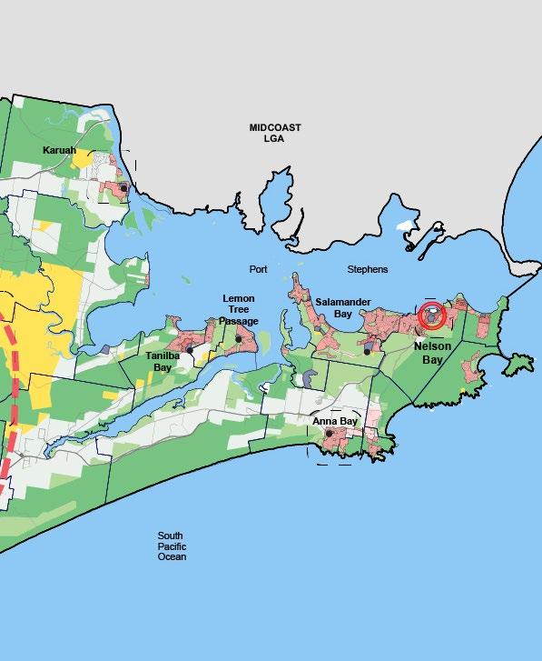
Port Stephens Local Government Area (LGA) spans 860 square kilometres and forms part of the Hunter region, Australia’s largest regional economy. It is bounded by Dungog Shire and Mid Coast Council areas to the north, Maitland City to the west, the City of Newcastle to the south. The Pacific Ocean lies to the east.
Port Stephens is home to approximately 72,700 people living in coastal communities, hinterland villages, rural retreats, or in the suburbs. Each local centre in the LGA offers housing and lifestyles that create diverse communities.
In 2018, Port Stephens was the third fastest growing LGA in the Hunter (behind neighbouring Maitland and Cessnock). Port Stephens attracts residents seeking homes with strong connections to the natural environment, including our beaches, rivers and waterfronts, forests, sand dunes, or a rural outlook.
Port Stephens supports a diverse range of
economic activities comprising agriculture and aquaculture, manufacturing, tourism, defence, construction and a mix of retail and small business. Proximity to Greater Newcastle employment centres and the resource rich Hunter Valley make Port Stephens an attractive location for business and residents.
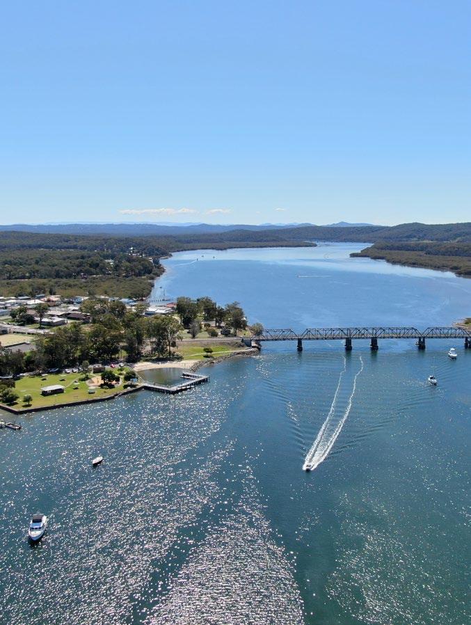
Raymond Terrace and Nelson Bay are regionally significant strategic centres and Tomago and Williamtown are employment centres identified as ‘Catalyst Areas’ in the GNMP and earmarked for significant growth and investment over the next 20 years. Due to its proximity to Williamtown and Tomago, as well the potential for residential growth, Medowie is likely to emerge as a strategic centre playing an important role both within Port Stephens and Greater Newcastle.
Newcastle Airport at Williamtown provides a global gateway for the region and is home to the Royal Australian Air Force (RAAF) base and associated aerospace and aviation support services. The arrival of the Joint Strike Fighter is anticipated to create some 3,000 direct and indirect jobs for civilian and defence workers and the expansion of the aerospace precinct around the airport is likely to have a significant impact on the growth of Port Stephens and Greater Newcastle.
Nelson Bay and the Tomaree Peninsula are major contributors to the regional visitor economy, hosting iconic tourist destinations that attract State, national and international visitors.
Access to Newcastle Airport, the Port of Newcastle, and key regional road and rail corridors connects Port Stephens to Greater Newcastle, the Hunter Valley, Australian capital cities and worldwide destinations.
Port Stephens is renowned for its scenic and natural beauty, with kilometres of coastal bushland and the largest mobile sand dunes in the southern hemisphere. The LGA is also home to environmentally significant areas with an underwater marine oasis at Tomaree, a substantial estuary system and several national parks as well as the Watagan to Stockton Green Corridor.
Port Stephens is important to the region’s drinking water supply, with the Grahamstown Dam Drinking Water Catchment, the Williams River Drinking Water Catchment, and the Tomago Sandbeds located in the LGA. Given the significant commitments to invest in Port Stephens and grow the regional and local economies, Port Stephens will continue to grow. The LSPS aims to balance growth and support vibrant communities in our unique environment.
Urban Residential
Figure 3
Port Stephens Structure Plan
State and National Parks
Rural Residential Employment Land Agricultural Land Water
Green Space
Rural Land Infrastructure
Council Boundary Metropolitan Frame Local Area Strategy Major Road Minor Road

State and National Parks Green Space
Rural Land
Water
Council Boundary
Metropolitan Frame Local Area Strategy Major Road Minor Road
Local Centre
Emerging Strategic Centre Strategic Centre
Port Stephens offers a variety of diverse centres and neighbourhoods that connect residents, visitors and workers with their community, the environment and opportunity.

Our centres are the hub of community life in Port Stephens. Residents and visitors use walking and cycling links to access local shops, schools, parks and sporting facilities. Shared spaces are activated to provide people with places to gather, celebrate and explore. New communities are planned to be healthy, active neighbourhoods and designed to support sustainable lifestyles.
People are attracted to Port Stephens for the strong connections to our natural areas including National Parks, wetlands, beaches and bushland. Our natural and cultural heritage is valued and reflected in the local character of our neighbourhoods and centres and communities are resilient to natural hazards such as flooding and bushfire.
Port Stephens supports a strong and varied economy with a growing national defence and aerospace hub and regionally significant manufacturing and tourism sectors. Port Stephens is the centre of an advanced transport network that provides easy local, regional and global connections and provides opportunities to export goods, services and skilled labour across Australia and the world. Opportunities for education and innovation make Port Stephens a desirable place for new business and provides a convenient lifestyle for local workers and their families.
The LSPS contains actions to achieve this vision by 2040.
This table shows how state and regional plans, and the CSP have informed the priorities in the LSPS. Environment Transport Economy
Housing
Create a workforce skilled and ready for the new economy
Deliver housing close to jobs and services Enhance environment, amenity and resilience for quality of life
Improve connections to jobs, services and recreation
PORT STEPHENS
Key Direction P1: Strong economy, vibrant local businesses, active investment
Key Direction P3: Thriving and safe place to live
Key Direction P3: Thriving and safe place to live
Key Direction P2: Infrastructure and facilities
Key Direction E1: Ecosystem function
Key Direction E3: Environmental resilience
Key Direction P3: Thriving and safe place to live
Key Direction P2: Infrastructure and facilities
Key Direction P3: Thriving and safe place to live
COMMUNITY STRATEGIC PLAN 2018 - 2028 PORT
Priority 1: Support the growth of strategic centres and major employment areas
Priority 2: Make business growth easier
Priority 3: Support tourism development and attract events
Priority 4: Ensure suitable land supply
Priority 5: Increase diversity of housing choice
Priority 6: Plan infrastructure to support communities
Priority
Priority 11: Integrate land use and transport planning
Priority 12: Enhance inter-regional connections


Port Stephens is a significant contributor to the Hunter region, Australia’s largest regional economy. It has been recognised by all tiers of government as a strategic location for economic growth, with a regionally significant tourist and visitor economy, a long established manufacturing sector, and Australia’s fastest growing aviation and defence hub.
Proximity to the M1 Motorway, Newcastle Airport and the Port of Newcastle make Port Stephens a convenient choice for business and creates opportunities to grow. Stunning natural assets attract tourists and visitors and make Port Stephens a desirable location for workers in the region seeking an enviable work life balance.
Port Stephens has recently attracted significant investment from both the public and private sectors and is earmarked to be a primary driver in the growth of regional NSW over the next 20 years.
The Port Stephens economy has a diverse and growing industry and employment base. Major employment areas are located at Williamtown, Tomago, Heatherbrae and the Tomaree Peninsula. Strategic centres at Raymond Terrace and Nelson Bay, as well as an emerging strategic centre at Medowie, complement the employment areas whilst supporting their own employment hubs. Williamtown and Tomago are identified as ‘Catalyst Areas’ in the Greater Newcastle Metropolitan area, and are likely to be the focus for employment and public and private infrastructure investment over the next 20 years.
Williamtown is the home of Newcastle Airport and the Royal Australian Air Force (RAAF) base, both significant economic drivers for the region. The arrival of the Joint Strike Fighter is anticipated to create some 3,000 direct and indirect jobs for civilian and defence workers
and, with the expansion of the aerospace precinct around the airport, Williamtown could support up to 5,500 jobs by 2040.
Tomago hosts internationally recognised and highly specialised manufacturing businesses and the GNMP identifies that a minimum 700 additional jobs are expected in the precinct by 2036.
The Tomaree Peninsula is the primary focus of a thriving tourism industry and a cornerstone of the Hunter tourist and visitor economy. Tourism currently provides 1,169 jobs in the main visitor destinations of Port Stephens and is a vital sector in terms of local employment and supporting the local and regional economies.
Council will
• Monitor the supply of employment land and work to ensure sufficient land is available should a shortfall in supply be identified.
• Proactively develop, implement and monitor the local strategic planning hierarchy incorporating land use planning, infrastructure plans as required to guide future growth.
• Support the growth of strategic and local centres with our community through established strategic area Implementation Panels.
• Council will co-operate and collaborate with the State Government in planning for a ‘Special Activation Precinct’ at Williamtown.
• Encourage growth through development and implementation of the Local Housing Strategy.
• Assess rezoning requests for consistency with the economic directions set in local strategies.
1.1 Prepare an economic prospectus for Port Stephens to attract business and investment.
Delivers Action 14 of Council’s adopted Raymond Terrace and Heatherbrae Strategy

1.2 Prepare land use studies and strategies to support the growing economy and facilitate jobs, including commercial and employment land studies to update the Port Stephens Commercial and Industrial Land Study 2010.
1.3 Complete strategic planning framework for strategic and local centres including infrastructure plans and funding strategies.
Immediate term
Immediate term
Short term
The local economy includes over 4,500 actively trading businesses, with most growth currently occurring in the manufacturing, tourism and defence sectors. New industries are also emerging to support a growing regional economy, taking advantage of easy access to regional, national and international markets via Newcastle Airport. The small business sector will continue to be a major jobs generator, particularly in creative, knowledge and service based, and tourism industries.
Business growth in local centres can contribute to more vibrant public spaces and local populations concentrated in and around our centres will support local economies.
By creating an environment where business can thrive, Council can facilitate the growth of innovative and successful enterprise and
ensure existing industries can continue to provide jobs and opportunities in our LGA.
• Evaluate business and tourism related opportunities for grant funding.

• Support the establishment of a new town centre that services Fern Bay.
• Monitor and report on the implementation of town centre strategies in partnership with residents and businesses through established Implementation Panels.
• Assess rezoning requests consistent with local strategies, including planning strategies for Fern Bay, Nelson Bay town centre, Medowie and Raymond Terrace.
• Provide advice to Local Aboriginal Land Councils (LALC) about their landholdings to assist in identifying options for economic opportunities.
2.1 Expand bulky goods at Heatherbrae, further strengthening its role as a key destination for this type of commercial development.
Delivers Action 2 of Council’s Raymond Terrace and Heatherbrae Strategy
2.2 Investigate Council owned land for commercial catalyst sites in centres, including sites that may be suitable for shared workspaces or start-up hubs.
Immediate term
Short term
The elements that make Port Stephens a great place to live and work also attract over a million visitors a year. It is one of Australia’s premier tourist and visitor destinations, generating in excess of $335 million for the local economy per annum.
The visitor economy in Port Stephens is strongly linked to the appeal of our unique natural environment including the Worimi Conservation Lands, Tomaree National Park and the Port Stephens - Great Lakes Marine Park.
In addition to its natural beauty, Port Stephens is a popular destination for both domestic and international visitors because it is easily accessible. It has close proximity to the M1

Motorway and easy access to the global gateways of Newcastle Airport and the Newcastle Cruise Ship Terminal.
There has been significant recent investment in the development of events and festivals, growing emerging tourism markets, and infrastructure such as the Tomaree Coastal Walk, the Koala Sanctuary at Anna Bay, and the Birubi Information Centre.
Council will
• Advocate for a major hotel and conference facility to be established in the LGA.
• Advocate for the State government to fund a coastal walk at Stockton beach to link to the Great North Walk.
3.1. Prepare and implement an events strategy.
3.2 Facilitate programs for business to encourage accessible tourism across Port Stephens.
3.3 Investigate opportunities to facilitate land uses that can support the tourist and visitor economy, including enabling farm gate sales along the Nelson Bay Road corridor and areas for boat and caravan storage in suitable locations.
Immediate term
Immediate term
Short term
There are tremendous opportunities to expand tourism, especially international tourism


As a major driver in Australia’s largest regional economy, Port Stephens has attracted significant investment in residential development that will support infrastructure and future job growth over the next 20 years. Major public, private and civil projects will make Port Stephens a regionally significant hub for the defence, tourism, manufacturing, aviation and aerospace, marine and energy sectors. In addition, future growth in housing will continue to support the growth and development of our strategic and local centres. These jobs will attract workers and families looking for a work life balance in one of the Hunter’s most beautiful and varied landscapes.
Port Stephens is a popular destination for retirees and other people looking to enjoy a relaxed lifestyle in beautiful surroundings. Future housing demand could also include ‘regional returners’, people who left the area as young adults and are choosing to move back to be close to family or because they value the lifestyle in Port Stephens. Equally, a sustainable supply of additional residential land provides greater opportunity for retaining our younger population, who can maintain links to existing centres and communities whilst accessing local and regional employment, education and entertainment.
Directions in State planning strategies require planning for a diverse range of future housing choices, from homes in coastal communities and spacious rural retreats to townhouses in local centres and granny flats in our suburbs. Providing housing diversity can have a positive impact on housing affordability and providing homes with access to jobs and centres will be key to meeting housing demand over the next 20 years.
Planning for new development in and around existing local centres and suburbs will contribute towards the targets for redevelopment of urban land set in the State Government’s GNMP.
In 2018, Port Stephens was the third fastest growing LGA in the Hunter, and given the projected job growth in our LGA over the next 20 years that trend is likely to continue.
Proximity to growing job markets in our LGA and Greater Newcastle will make living locally an attractive option. Most existing housing opportunities in Port Stephens are located within 15 minutes of a Greater Newcastle employment centre. Existing and future residential areas, such as Fern Bay, Kings Hill, and Medowie can provide housing options less than 30 minutes from major employment areas in Williamtown, Maitland, Broadmeadow, and Newcastle City centre.
Port Stephens has a housing market that is supply driven and without an adequate supply of land in the right locations, housing affordability is likely to be negatively impacted.
Council will
• Review or prepare local strategies, including a local housing strategy, to respond to changing circumstances.
• Council will continue to contribute to the State Government’s Greater Newcastle Urban Development Program.
• Assess rezoning requests for consistency with the directions for housing in local strategies.
4.1 Prepare and implement a local housing strategy to ensure suitable land supply and other planning priorities for housing identified in the LSPS.
Immediate term
Housing diversity means a range of housing types, sizes, tenures and price points are available to meet demand in the right locations.
Housing choices in our LGA can include new estates, rural lifestyle lots, terraces, duplexes, small lot housing, shop top housing, granny flats, and homes in retirement villages and lifestyle communities.
Housing diversity in some locations can promote the more efficient use of existing infrastructure or promote the more efficient use of land in order to protect the conservation and economic value of coastal, rural and natural environments. Some housing types offer energy efficiencies and other
sustainability benefits. Some models of home ownership can offer seniors independent living in close knit communities.
Planning for diverse housing can mean prioritising what people value and planning for a range of housing types and sizes to suit different lifestyles.
Council will • Implement housing diversity actions contained in adopted strategies.
Delivers Action 25 of the Raymond Terrace and Heatherbrae Strategy.
5.1 Council will amend the LEP to support higher densities in Nelson Bay town centre and surrounding the Raymond Terrace town centre.
Delivers Action 7 in the Progressing the Nelson Bay Town Centre and Foreshore Strategy: A revised implementation and delivery program (Nelson Bay Delivery Program).
Delivers Action 15 in Raymond Terrace and Heatherbrae Strategy.
5.2 Investigate and promote the development of suitable catalyst sites in the Raymond Terrace and Heatherbrae Strategy for diverse housing opportunities.
Delivers Action 25 of the Raymond Terrace and Heatherbrae Strategy.
Immediate term (NB) Immediate term (RT)
Short term
As Port Stephens grows, communities will require housing, infrastructure and services that can meet changing needs. Liveable communities have employment, housing and transport options that meet their needs and enjoy access to quality public spaces, community or sporting facilities, and services such as medical care or child care. Increasingly, digital infrastructure and smart technology can positively impact the sustainability, resilience and safety of our community.
Port Stephens is significant to the Hunter Region’s drinking water supply, including Grahamstown Dam Drinking Water Catchment, the Williams River Catchment, and the Tomago
Sandbeds. Planning for new development in the vicinity of drinking water catchments to maintain water quality will protect these regional infrastructure assets.
Council will
• Align infrastructure in local strategies with the Local Infrastructure Contributions Plans to ensure new development and infrastructure can be delivered in line with growth.
• Collaborate with infrastructure providers such as Hunter Water to ensure the security in the supply of infrastructure.
• Assess rezoning requests for consistency with local strategies that identify infrastructure needs.
6.1 Council will develop a Smart City Blueprint to plan for digital infrastructure and data management.
6.2 Council will collaborate with Hunter Water Corporation in the preparation of a drainage strategy for Medowie. Aligns with the Medowie Planning Strategy
6.3 Council will review the Port Stephens Infrastructure Specifications to deliver best-practice guidelines for planning, designing and developing sustainable built environments.
Immediate term
Short term
Short term


Port Stephens is home to a variety of natural landscapes including coastal plains, sand dunes, rivers, valleys, forests, beaches, wetlands and wooded ridgelines. Port Stephens supports an abundant natural environment with remarkable flora, fauna and marine species including koalas, oysters, dolphins and whales. Our natural and cultural heritage shapes the local character and identity of our centres, towns and villages and underpins local economies, including aquaculture and the visitor and tourist economy.
Managing impacts on the natural environment and planning for green connections promotes and protects biodiversity, natural habitats and cultural heritage. Our natural assets can help mitigate the impacts of urban development, increase resilience to natural hazards such as flooding, and contribute towards economic development and tourism.
Access to green space can support the promotion of biodiversity and provides residents with lifestyles that promote wellbeing and enhances quality of life. Our parks, gardens and recreational facilities provide opportunities to soften the interface between urban and other development and the natural landscape provides an enhanced visitor experience.
Green spaces can serve as important habitat corridors as well as creating places that enhance social connections and contribute to defining communities.
Port Stephens is home to unique areas of high environmental significance including the Hunter estuary and wetlands, the Stockton sand dunes, the Watagan to Stockton Green Corridor, the Hunter and Williams rivers, and National Parks. The blue and green grid of natural landscapes, open spaces and waterways contributes to conserving high biodiversity values and includes Stockton beach, Hunter Botanic Gardens, the Hunter River, and areas in Port Stephens that support the koala population.
Healthy natural environments support clean air, water and healthy soils. Biodiversity in Port Stephens supports ecological, cultural, recreational, economic and scenic values. Managing environmental impacts and promoting biodiversity benefits community wellbeing and seeks to ensure the health, diversity and productivity of our environment is maintained or enhanced for the benefit of future generations.
7.1 Council will review and update the tree and vegetation management framework.
Immediate term
7.2 Council will prepare and implement a Biodiversity Strategy to avoid, minimise and offset impacts on biodiversity. Short term
7.3 Council will review and update the koala management framework. Aligns with the Medowie Planning Strategy
Short term
Port Stephens experiences a wide range of natural hazards such as flooding, coastal inundation, erosion and bushfires. Natural hazards and risk management influence how we plan for future growth and new development in Port Stephens.
Strategies to build community and environmental resilience to natural hazards and climate change support positive economic, environmental and social outcomes. Reducing risk exposure and increasing resilience to natural hazards ensures that people, property, infrastructure, the economy and the environment can withstand future hazard events.
Where and how we build communities can impact resilience to hazards and climate change. Planning for land use can include taking into consideration evacuation planning principles to minimise risk to life or reduce the burdens on emergency services. Choice of materials, design and efficient use of water and energy can make the built environment more resilient and promote ecologically sustainable development.
Council will
• Implement the recommendations of Council’s Flood Committee.
• Assess rezoning requests for consistency with environmental, sustainability and risk management directions in local, regional and state planning framework.
8.1 Council will review the Climate Change Adaptation Action Plan. Immediate term
8.2 Council will assist the NSW Rural Fire Service in reviewing the bushfire mapping for Port Stephens Short term
8.3 Council will prepare and implement a Coastal Management Program to mitigate natural hazards and incorporate resilience measures that promote ecologically sustainable development.
8.4 Council will review existing policies for water sensitive design and consider options to improve outcomes for the environment and home owners.
8.5 Council will develop a Sustainability Strategy which will include actions for energy savings, reduction of waste and encourage low carbon emissions.
Short term
Short term
Short term
Ecologically sustainable development should be recognised as a key commitment
Agriculture is an important sector of the Port Stephens economy, contributing $107 million of exports annually and providing around 400 jobs. Poultry and oyster farming are the dominant agricultural industries in the LGA and agriculture is significant to the local character and cultural heritage of villages in the rural west of Port Stephens and some coastal areas. Some types of agriculture support the visitor and tourist economy and contribute to unique visitor experiences.
Productive agricultural land in Port Stephens can support healthy neighbourhoods and locally produced food is generally more sustainable, expending less energy, emissions
and ‘food miles’. There may be opportunities for existing agricultural businesses to capitalise on complementary uses such as artisan food premises, boutique breweries and wedding reception venues which can provide supplementary income for farm based businesses.

Managing the impacts of new development in some areas requires assessing potential land use conflicts to ensure existing and potential agricultural uses are protected. This can include managing new housing and land fragmentation in rural areas and managing water quality and other natural resources that sustain local agricultural industries such as oyster aquaculture.
9.1 Prepare a local housing strategy that includes assessment criteria for new rural residential development to protect existing and potential productive agricultural land.
9.2 Review local plans to encourage niche commercial, tourist and recreation activities that complement and promote agricultural industries.
Immediate term
Short term
Planning Priority 9 | Protect and preserve productive agricultural land
Protect the distinctive rural heritage of the West Ward area
Planning Priority 10 | Create people friendly spaces in our local centres where people can come together
Planning for healthy communities promotes wellbeing and encourages active living. Healthy neighbourhoods include public spaces and green spaces where people can come together and feel connected to the natural environment. Liveable communities with access to shared space and adequate recreational areas foster strong social connections. Our public places in and around local centres can provide spaces where people can meet, play or explore. Place making can empower communities to make spaces more inviting and create opportunities for residents and visitors to participate in events that bring people together.
Council will
• Improve access to open space, recreation areas and waterways by implementing local strategies such as the Recreation Strategy, Pathways Plan and the Pedestrian Access and Mobility Plans.
• Investigate opportunities in existing centres to provide better public spaces and plan for public spaces that:
Improve amenity and grow connections ─
Include public art and are suitable for community events
Support the ageing population ─
Enhance local character, including natural and cultural heritage
Facilitate the reuse of heritage places ─
Meet objectives in the Better Placed Framework and Regional Urban Design Guide (published by the NSW Government Architect’s Office) and the Movement and Place Framework (published by Transport for NSW)
• Support placemaking initiatives in town centres.
• Consult with LALCs in the review of local planning strategies to identify and protect Aboriginal cultural heritage values.
• Undertake community consultation to ensure town centre revitalisation projects respond to community values and priorities.
• Assess rezoning requests for consistency with the directions in local strategies for public spaces.
10.1 Prepare a Community Wellbeing Strategy to promote liveable communities. Short term
10.2 Support the activation of public spaces, including events, public art, small business opportunities, markets and other temporary uses. Short term
10.3 Prepare a Public Domain Plan for Raymond Terrace. Immediate term


Port Stephens is connected by local, regional and global transport networks that provide easy access to jobs, interstate and overseas travel, education, and health services. Access to the global gateways that are Newcastle Airport and the Port of Newcastle, as well as the M1 Motorway, and regional rail corridors make Port Stephens a well-connected place to live and a hub for business and industry.
Local transport infrastructure supports thriving communities and businesses. Local roads, pathways, bus shelters, car parks and other transport facilities, such as the Birubi Point Aboriginal Place Tourism Interchange, can connect Port Stephens to Greater Newcastle, connect our local centres and support local economies, including the tourism and visitor economy.
New development in Port Stephens will contribute funding towards local infrastructure that provides or upgrades facilities, including sporting, community and cultural facilities, road upgrades and cycle paths. Infrastructure that connects residents to public transport or promotes walking and cycling can facilitate healthy communities.
Investment in town centre rejuvenation will include transport infrastructure upgrades, such as parking strategies and roadworks, to revitalise centres and activate main streets. Pedestrian connections and connections to public transport will ensure our centres are accessible. Local business will benefit from attractive and accessible centres that are destinations for residents and visitors.
Planning for land use to integrate with transport infrastructure can have significant social, environmental and economic benefits. Transport planning can support planned land uses, create demand for different land uses, or change the character of a place and the lifestyles of the people that live and work in our LGA.
Transport infrastructure can facilitate the land uses that will grow the local and regional economies in Port Stephens. Improved infrastructure can make tourist destinations more accessible, and infrastructure such as trails and cycle ways can themselves attract visitors for tourism or recreational opportunities. Transport options can be provided around employment and retail centres that supports employees living and working locally and encourages people to shop locally.
Planning for communities that can access public transport, walking and cycling paths promotes more active living and can help reduce car dependency, congestion and commuting time. Transport planning can make our public spaces more attractive and functional. Town centres that are accessible support local businesses by connecting customers, employees and related industries. Public spaces that balance movement and place are people friendly and inviting for residents and visitors. Council will
• Undertake town centre upgrades to support accessibility and improved connections, including works to improve parking and pedestrian connectivity in town centres.
Aligns with local strategies for Raymond Terrace, Medowie and Nelson Bay, the Nelson Bay Public Domain Plan and the Nelson Bay Citizens Parking Panel Report.
• Seek grant funding for infrastructure that supports healthy communities such as footpaths, shared paths and end of trip facilities for cyclists in centres.
• Support investigations to establish a ferry terminal at North Stockton/Fern Bay.
Delivers Action 19 in the draft Fern Bay and North Stockton Strategy.
• Assess rezoning requests for consistency with the directions for transport infrastructure in local strategies.
Immediate term

11.1 Identify and prioritise delivery of pathways that form part of, or connect to, regional trails.
Port Stephens has established connections to the Hunter, Sydney and other capital cities, and international destinations. Our connections support business and industry, our visitor and tourist economy, and residents.
As a global gateway, Newcastle Airport is central to unlocking unrealised potential for the tourism industry and provides an opportunity for the Hunter region to export goods, services and skilled labour across Australia and the world.
The Airport provides national and international opportunities to grow local businesses and supports a more agile workforce, including fly in and fly out workers and people choosing to live in Port Stephens and work remotely. People living in Port Stephens also have access jobs and services Greater Newcastle with major residential areas in Port Stephens located within 15 minutes of a Greater Newcastle employment centre.
Proximity to the Port of Newcastle, the M1 motorway, and regional rail corridors supports local business and industry to access markets in Sydney, the Hunter Valley, northern and central NSW, and interstate.
There are opportunities to improve public transport and active transport connections from Port Stephens to Greater Newcastle centres and beyond. Planning for future rail connections, in particular to support interregional freight or passenger connections to Newcastle Airport, will further enhance existing transport links.
Council will
• Advocate for improved transport connections, including more active and public transport, from Raymond Terrace, Medowie and Fern Bay to major employment areas at Tomago and Williamtown and other centres in Greater Newcastle.
• Support State agencies to identify a potential future freight corridor to Newcastle Airport.
• Work with Maitland City Council to coordinate infrastructure and land use planning in areas with connections to the Maitland LGA.
• Advocate for rail connections between Newcastle Airport and Newcastle City and to connect Port Stephens to the Hunter region, the NSW North Coast and Brisbane.


The Port Stephens LSPS has been prepared in accordance with section 3.9 of the EP&A Act. It gives effect to the HRP and GNMP, implementing the directions and priorities at a local level. It puts forward the vision and long-term land use strategy for Port Stephens for the next 20 years. To realise the vision, amendments to the LEP, DCP and CPs may be required to provide the framework for delivery.
In accordance with section 3.33(2) of the EP&A Act the assessment of rezoning requests will include whether the proposed instrument will give effect to the LSPS and will comply with relevant directions under section 9.1 of the EP&A Act.
On adoption of the LSPS, Council will contact and invite the proponents for selected existing planning proposals to provide additional information to support the further assessment of the proposal, including (where necessary) an amended planning proposal.
Council will monitor, review and report on its LSPS to ensure that the planning priorities are being achieved.
Implementation of the LSPS will be monitored and reported through the Integrated Planning and Reporting Framework (IP&R) under the Local Government Act 1993. The LSPS will
support Council’s CSP, and will be reviewed concurrently every four years, commencing in 2024. The review will take into account changes to the HRP, the GNMP, Council’s updated CSP and other relevant local planning strategies.
Actions contained within the LSPS are the primary responsibility of Port Stephens Council. However, the successful implementation of the actions will require the input, advice and assistance from a range of additional groups and organisations.
Council will continue to work hard to maintain effective partnerships with the following organisations and State government agencies to support the realisation of the plan:
• Aboriginal Strategic Committee
• Community Groups
• Heritage Committee
• Hunter and Central Coast Development Corporation
• Hunter Joint Organisation
• Hunter Water Corporation
• Flood Committee
• Newcastle Airport
• NSW Department of Planning, Industry and Environment
• Roads and Maritime Services
• Strategic Arts Committee
• Strategic Centre Implementation Panels
• Urban Development Program
1.1 Prepare an economic prospectus for Port Stephens to attract business and investment.
1.2 Prepare land use studies and strategies to support the growing economy and facilitate jobs, including commercial and employment land studies to update the Port Stephens Commercial and Industrial Land Study 2010.
1.3 Complete strategic planning framework for strategic and local centres including infrastructure plans and funding strategies.
2.1 Expand bulky goods at Heatherbrae, further strengthening its role as a key destination for this type of commercial development.
2.2 Investigate Council owned land for commercial catalyst sites in centres, including sites that may be suitable for shared workspaces or start-up hubs.
Economic Development and Tourism Strategic Planning Immediate term
Strategic Planning Not Applicable Immediate term
Strategic Planning Not Applicable Short term
Strategic Planning Not Applicable Immediate term
Economic Development and Tourism Not Applicable Short term
3.1. Prepare and implement an events strategy.
3.2 Facilitate programs for business to encourage accessible tourism across Port Stephens.
3.3 Investigate opportunities to facilitate land uses that can support the tourist and visitor economy, including enabling farm gate sales along the Nelson Bay Road corridor and areas for boat and caravan storage in suitable locations.
4.1 Prepare and implement a local housing strategy to ensure suitable land supply and other planning priorities for housing identified in the LSPS.
5.1 Council will amend the LEP to support higher densities in Nelson Bay town centre and surrounding the Raymond Terrace town centre.
5.2 Investigate and promote the development of suitable catalyst sites in the Raymond Terrace and Heatherbrae Strategy for diverse housing opportunities.
6.1 Council will develop a Smart City Blueprint to plan for digital infrastructure and data management.
6.2 Council will collaborate with Hunter Water Corporation in the preparation of a drainage strategy for Medowie.
6.3 Council will review the Port Stephens Infrastructure Specifications to deliver best-practice guidelines for planning, designing and developing sustainable built environments.
7.1 Council will review and update the tree and vegetation management framework.
7.2 Council will prepare and implement a Biodiversity Strategy to avoid, minimise and offset impacts on biodiversity.
7.3 Council will review and update the koala management framework.
8.1 Council will review the Climate Change Adaptation Action Plan.
8.2 Council will assist the NSW Rural Fire Service in reviewing the bushfire mapping for Port Stephens
8.3 Council will prepare and implement a Coastal Management Program to mitigate natural hazards and incorporate resilience measures that promote ecologically sustainable development.
8.4 Council will review existing policies for water sensitive design and consider options to improve outcomes for the environment and home owners.
8.5 Council will develop a Sustainability Strategy which will include actions for energy savings, reduction of waste and encourage low carbon emissions.
9.1 Prepare a local housing strategy that includes assessment criteria for new rural residential development to protect existing and potential productive agricultural land.
9.2 Review local plans to encourage niche commercial, tourist and recreation activities that complement and promote agricultural industries.
10.1 Prepare a Community Wellbeing Strategy to promote liveable communities.
10.2 Support the activation of public spaces, including events, public art, small business opportunities, markets and other temporary uses.
10.3 Prepare a Public Domain Plan for Raymond Terrace.
11.1 Identify and prioritise delivery of pathways that form part of, or connect to, regional trails.
Economic Development and Tourism
Economic Development and Tourism
Not applicable Immediate term
Not applicable Immediate term
Strategic Planning Not applicable Short term
Strategic Planning Not applicable Immediate term
Strategic Planning Not applicable Immediate term (RT) Immediate term (NB)
Strategic Planning Not applicable Short term
Strategic Planning Not applicable Immediate term
Flooding and Drainage
Strategic Planning Short term
Development Engineering Strategic Planning Short term
Natural Resources Strategic Planning Immediate term
Natural Resources Strategic Planning Short term
Natural Resources Strategic Planning Short term
Natural Resources Strategic Planning Immediate term
Natural Resources Strategic Planning Short term
Natural Resources Strategic Planning Short term
Development Engineering Strategic Planning Short term
Natural Resources Not applicable Short term
Strategic Planning Not applicable Immediate term
Strategic Planning Not applicable Short term
Strategic Planning Community Development and Engagement Short term
Economic Development and Tourism
Community Development and Engagement Short term
Strategic Planning Not applicable Immediate term
Civil Assets Not applicable Immediate term
116 Adelaide Street | PO Box 42 Raymond Terrace NSW 2324 council@portstephens.nsw.gov.au 02 4988 0255
