POLICY CONTEXT
BACKGROUND 14 GOAL 1: A competitive economy with regional services, including transport, health, justice, government, commercial, retail, industrial and entertainment 15 Direction 1.1 Growing a more regionally competitive centre by providing lands to strengthen the retail offering of Raymond Terrace and facilitating Heatherbrae as a destination for bulky goods 17 Direction 1.2 Enhancing transport and mode connectivity, including road, public transport, footpath and cycleway connections within Raymond Terrace and Heatherbrae 20 Direction 1.3 Planning for regional soft infrastructure services to meet the needs of a growing community 23 Direction 1.4 Raising the profile of Raymond Terrace through a commercial strategy/prospectus 26 GOAL 2: A city of housing choice with homes that meet our needs and lifestyles with a focus on providing for affordable accommodation, which includes seniors living and student accommodation 27 Direction 2.1 Enabling development that supports compatible land clustering 'like with like' land uses by the identification of key precincts, such as Kangaroo Street for Light Industrial, and Heatherbrae for bulky goods. 29 Direction 2.2 Providing opportunities for affordable housing and seniors/retirement living 30 Direction 2.3 Council facilitating the development of catalyst sites 32 GOAL 3: A great place to live with quality public and private spaces that are accessible 33 Direction 3.1 Improving the quality of existing public open spaces and undeveloped sites 35 Direction 3.2 Identifying locations for future passive open space 36 Direction 3.3 Implementing main street upgrades 41 GOAL 4: A resilient city with clear directions for improved social, environmental and economic outcomes 42 Direction 4.1 Retaining connections to the past through the integration of heritage into development 43 Direction 4.2 Developing a streetscape design guideline for consistency in the town centre 43 Direction 4.3 Establishing an implementation panel to provide continual input 44 Direction 4.4 Reinforcing the role of Raymond Terrace within the Local Government Area commercial hierarchy as the prominent commercial centre to service the future needs of Kings Hill, Medowie, Tomaree Peninsula and other smaller towns
2 CONTENTS 3 EXECTUIVE SUMMARY 9
45
INTRODUCTION 10 THE STRATEGY 12
13
45 IMPLEMENTATION
NEXT STEPS 45 MONITORING AND REVIEW
EXECUTIVE
Introduction
The Raymond Terrace & Heatherbrae Strategy is an action plan that can be best summarised by viewing the implementation table and two maps. This Table and the accompanying maps seek to clearly illustrate that this Strategy is an 'action strategy' that seeks to make Raymond Terrace and Heatherbrae a strong regional centre and a great place to live work and play. Implementation
The Strategy identifies the following land for 4.5ha of B5 Business Development on the western side of the Pacific Highway to facilitate Heatherbrae as a 'key destination for bulky goods':
2253 Pacific Hwy (Pt Lot 62 DP 578367)
2259 Pacific Hwy (Pt Lot 1 DP 836879) 2249 Pacific Hwy (Lot 1 DP 161865) 2265 Pacific Hwy (Pt Lot 1 DP 1113232) 2273 Pacific Hwy (Pt Lot 2 DP 1113232)
3 Promote catalyst sites for commercial development to underpin William Street as the main street of activity catalyst sites are discussed under Action No. 24 (p.21)
Short SP ED
Ongoing ED PS
Direction 1.2 Enhancing transport and mode connectivity, including road, public transport, footpath and cycleway connections within
3
SUMMARY
Key: ED Economic Development Unit SP Strategic Planning Unit IL Individual Landowners RMS Roads & Maritime Services FS Facilities and Services Group PS Property Services Section DAC Development Assessment & Compliance Section CL Crown Land GOAL 1 A competitive economy with regional services, including transport, health, justice, government, commercial, retail, industrial and entertainment Direction
Growing a more regionally competitive centre by providing lands to strengthen the retail offering of Raymond Terrace and facilitating Heatherbrae as a destination for bulky goods No Action Timing Owner 1
Commercial Core and IN2 Light Industrial
Medium ED SP
Table
1.1
Monitor the supply of B3
lands in Raymond Terrace as part of the review of the Port Stephens Planning Strategy that is set to occur in 2015/16. Then monitor the supply of these lands on an annual basis once the commercial strategy has been developed in accordance with Action No.14.
2
Raymond Terrace and Heatherbrae No Action Timing Owner 4 Identify ‘missing road links’ within the site specific Development Control Plan for Raymond
and Heatherbrae Short SP 5 Finalise the construction and maintenance of the multi transport hub at 'The Close' Short FS 6 Update and implement the Raymond
Pedestrian
Complete priority links and advocate for connections
Medium FS 7 Support
FS
FS
Terrace
Terrace
& Cycle Strategy.
to the wider network, such as from Raymond Terrace to Newcastle and Maitland.
future proposals for increased public transport from Port Stephens. Ongoing ED SP
8 Advocate for the southern interchange of the Heatherbrae Pacific Highway to provide northern access to Heatherbrae. Ongoing ED SP 9 Undertake a detailed traffic analysis/management plan to determine the future traffic environment of Heatherbrae. This analysis will also identify opportunities for improved accessibility to support additional lands for bulky goods premises. Timing of this action is subject to the finalisation of the Heatherbrae Bypass Plan by RMS. Medium ED SP
10 Address the informal access arrangements that have been created over 'community land' as defined under the Local Government Act 1993 for businesses with direct access to the Pacific Highway. Long SD FS DAC RMS
11 Consolidate the identified portions of roads within Riverside Park and the Raymond Terrace Trotting Track into the adjoining Crown Land Reserves
Long FS CL
Direction 1.3 Planning for regional soft infrastructure services to meet the needs of a growing community
No Action Timing Owner
12 Advocate for Raymond Terrace amongst major institutions, such as the University of Newcastle, about the availability of affordable land and key catalyst sites both in Council and in private ownership. Catalyst sites and those with subdivision potential have been identified under Action No.24
13 Recognise the role in providing services to those smaller surrounding centres, such as Medowie, Dungog, Kings Hill and Salt Ash through providing a more detailed audit of community services than what is provided under Action No.1 in the review of the Port Stephens Planning Strategy
Ongoing ED PS
Medium SP
Direction 1.4 Raising the profile of Raymond Terrace through a commercial strategy/prospectus
No Action Timing Owner
14 Develop an economic/commercial strategy/prospectus that promotes land availability and its development potential, which will:
Assist landowners in understanding the development potential of their land under the planning framework
Provide prospective developers with an understanding of the precincts and business agglomerations present in Port Stephens
Provide current data (i.e. planned infrastructure investments, approved development types, etc.) through an online medium
Incorporate data regarding board market parameters from the Property Services Section of Council
Follow examples, such as the Wollongong City Council. May 2014, 'Wollongong Investor Prospectus' or 'Lake Macquarie Love the Lake'
Short ED PS
No
15 Investigate options to increase the maximum height of building from 9 to 15 metres at locations zoned R3 Medium Density Residential and from 12, 15 and 19 metres to 35 metres (10 storeys) at locations zoned B3 Commercial Core within the town centre to support opportunities for increased density.
16 Support the improvement of quality open space within Raymond Terrace and contribute to the target of 300 dwellings by implementing the Boomerang Park Masterplan
17 Insert the standard instrument clause for activated street frontages into the Port Stephens Local Environmental Plan 2013 (NSW) and identify where development is to provide activated street frontages within the town centre to facilitate street activation
18 The Department of Defence Administration Building is to provide a boardwalk/path along the Hunter River as part of their existing condition of consent. Council is to work with this property owner to finalise this portion of the boardwalk.
19 Identify a portion of land at the end of Speedy Lock Lane, Heatherbrae, known as Lot 173, DP 808771 from RU2 Rural Landscape to R2 Low Density Residential as a potential site for greenfield development to assist in achieving housing targets as identified for Raymond Terrace under the Lower Hunter Regional Strategy
20 Monitor the subdivision of lots within the town centre as a part of the review of the Port Stephens Planning Strategy and facilitate discussions with developers for ways in which Council can assist in achieving density for those locations zoned R3 Medium Density Residential such as reduced parking requirements. An excellent forum to achieve this is provided by the Port Stephens Council Industry Reference Group (IRG).
21 Facilitate and encourage shop top housing within the town centre through ensuring the regulatory framework caters for this development type
22 Review/Audit of future potential residential sites through the review of the Port Stephens Planning Strategy (PSPS)
Direction 2.2 Providing opportunities for affordable housing and seniors/retirement living
Short SP IL
Short SP
Short SP
Short DSC IL
Medium SP ED IL
Medium SP ED DSC
Short SP
Medium ED PS
No Action Timing Owner
4
GOAL 2 A city of housing choice with homes that meet our needs and lifestyles with a focus on providing for affordable accommodation, which includes seniors living and student accommodation
Direction 2.1 Enabling development that supports compatible land clustering 'like with like' land uses by the identification of key precincts, such as Kangaroo Street for Light Industrial, and Heatherbrae for bulky goods.
Action Timing Owner
23 Explore legislative and regulatory framework for further possible mechanisms to achieve small lot housing within the zone R3 Medium Density Residential under the Port Stephens Local Environmental Plan 2013 (NSW).
24 Similar to Action No.12, liaise with the University of Newcastle or private accommodation providers to promote Raymond Terrace as a location with affordable land, existing services and accessibility to the Lower Hunter Region.
Direction 2.3 Council facilitating the development of catalyst sites
Medium SP
Ongoing ED
No Action Timing Owner
25 Ensure the commercial strategy/prospectus under Action No.14 incorporates these sites and places a detailed emphasis on their most suited use and potential.
GOAL 3 A great place to live with quality public and private spaces that are accessible
Direction 3.1 Improving the quality of existing public open spaces and undeveloped sites
Medium ED
No Action Timing Owner 26 Implementation of the Boomerang Park Masterplan subject to securing appropriate funding, which includes quality paths, play equipment, etc.
27 The Streetscape Design Guideline, which is proposed under Action No.36 is to take into account urban design elements, such as what trees and/or vegetation would be most appropriate for open spaces
28 Explore the possibilities for the activation of undeveloped sites, such as those sites identified as 'catalyst sites'. For example, the former Raymond Terrace sports field regularly hosts visiting circuses. While the site on the corner of Adelaide and William Streets could host pop up stalls to bring people into the town centre.
Direction 3.2 Allocation and integrating locations for future passive open space
Medium FS
Medium SP FS DAC
Medium ED
No Action Timing Owner
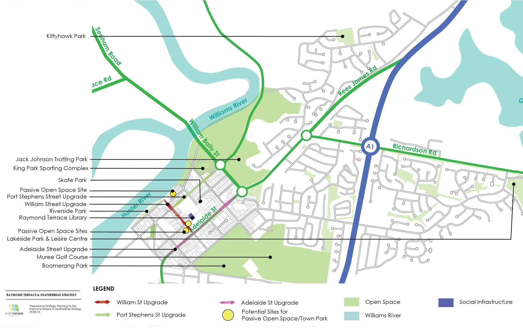
29 Determine a preference for a location for passive open space, whether it be one of the three that have been identified: 51 William Street (Old Fire Station Building) and 53 William Street (Old RTA Building);
42 William Street (Port Stephens Communicate Building);and
16 & 18 King Street (Marriage Trees). or another suitable alternative. Any future development of these sites could be constructed in lieu of development contributions or Council may seek to construct it with the assistance of federal or state government grants.
Long SP FS IL 30 In accordance with Action 11.1.1.9 of the Port Stephens Community Strategic Plan 'Prepare a project plan to redefine the civic present of Raymond Terrace'.
5
users, links
car
GOAL 4 A resilient city with clear directions for improved social, environmental and economic outcomes Direction 4.1 Retaining connections to the past through the integration of heritage into development No Action Timing Owner 34
Raymond
Direction
Development
streetscape design guideline for consistency
No Action Timing Owner 35
Long SP ED Direction 3.3 Implementing main street upgrades No Action Timing Owner 31 Consider further detail on the three options for the upgrade of William Street once funding is identified Short FS SP ED 32 Concept designs and costings will be developed for the upgrade of Adelaide and Port Stephens Streets and subsequently placed on public exhibition for comment Long FS 33 Develop a parking management plan for Raymond Terrace defining the goals for parking provision and incorporate a Parking Structure Plan with a hierarchy of
to policies and controls. Considering a proposal to develop the former sports field site would result in a significant amount of
spaces Long FS
Part D9
Terrace Town Centre of the Port Stephens Development Control Plan provides additional guidance to heritage and incentives for the integration of historical significance into new development and the preferred location for gateway signage. The proposed Streetscape Design Guideline under Action No.36 will detail a common approach and standard to signage within the Raymond Terrace town centre Short SP
4.2
a
in the town centre
Develop a streetscape design guideline to be used in the implementation of the William Street, Port Stephens Street and Adelaide Street upgrades. This guideline should seek to provide the same level of detail as the example provided within the City of Ipswich. 2013, 'Ipswich Streetscape Design Guideline A guide for Council, Short SP FS
Developers and the Community'. This guideline will explicitly cover the following matters, which were raised during the exhibition period:
Consistent paving on the west/riverside footpath to match town/eastern side;
Consistent themed historic signage;
Specific and distinct furniture and lighting for the King Street Precinct; and
Style and character of public art that is in keeping and reflective of the locality Direction 4.3: Establishing an implementation panel to provide continual input
No Action Timing Owner
36 Formulate an implementation panel that meets formally on a regular basis to drive the implementation of the actions contained within this strategy. The 'Terms of Reference' of this group will be formalised by Council when the strategy is reported to Council at the completion of the exhibition period.
37 Any future revision of this Strategy is to acknowledge the drainage matters identified by numerous flood and drainage studies completed for Raymond Terrace/Heatherbrae and provide a critical path towards addressing these matters.
Short SP ED
Short SP ED
Direction 4.4 Reinforcing the role of Raymond Terrace within the Local Government Area commercial hierarchy as the prominent commercial centre to service the future needs of Kings Hill and Medowie
No Action Timing Owner
38 The implementation panel identified under Action No.37 is to engage and seek input from the sub region, such as representatives from Newcastle Airport, Medowie, Kings Hill, Karuah, Dungog, Tomaree Peninsula and Tomago
Short SP ED
6
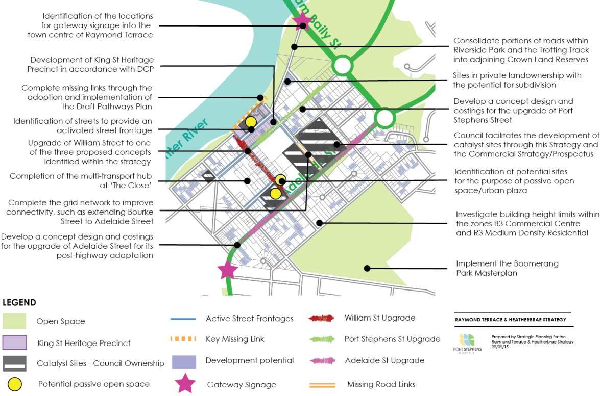
Figure L: KEY ACTION MAP RAYMOND TERRACE
7
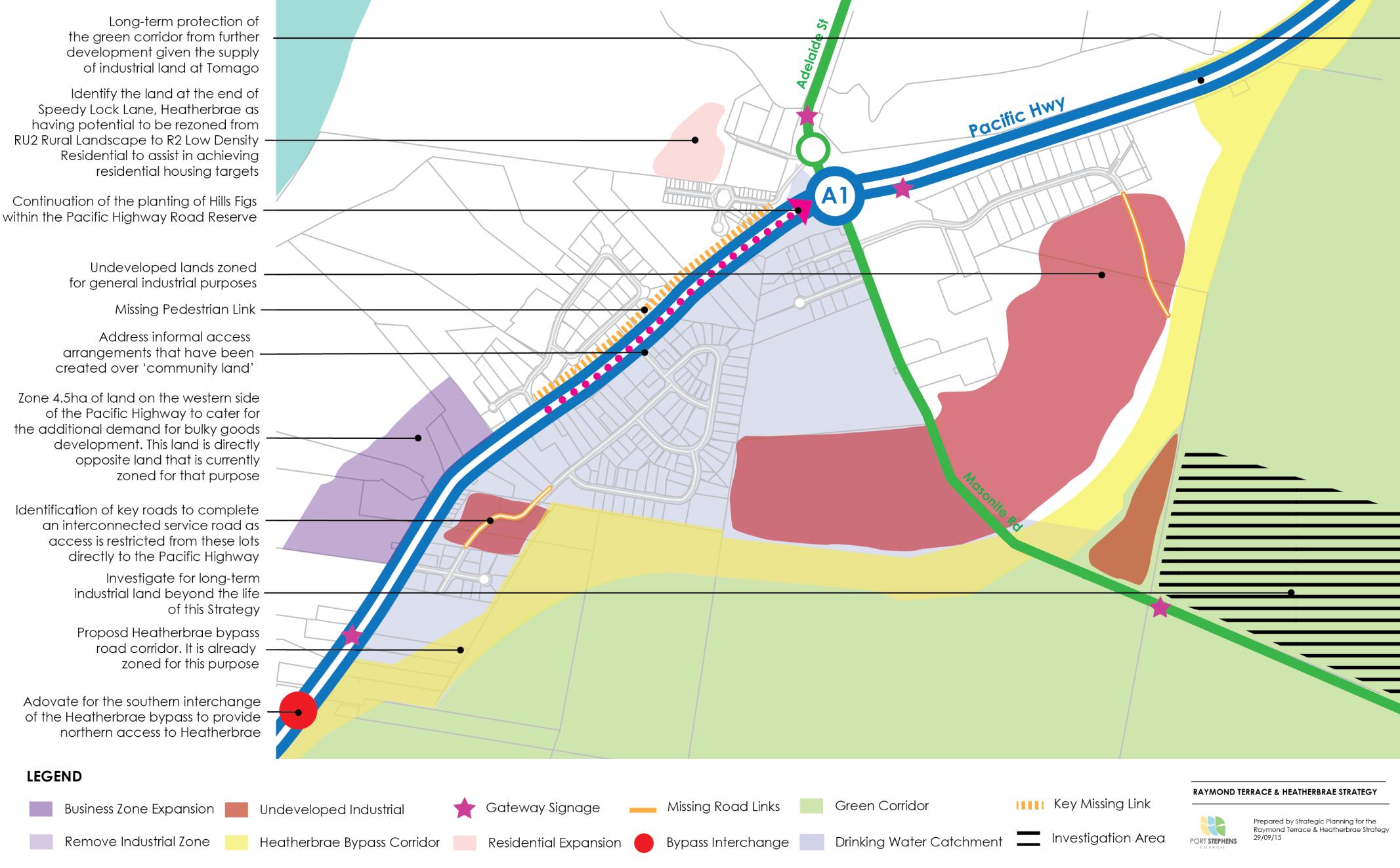
Figure M: KEY ACTI ON MAP HEATHERBRAE

8
INTRODUCTION
Raymond Terrace was established in 1837 based on its strong connections with the river
Raymond Terrace and its neighbouring centre of Heatherbrae are now home to over 12,000 people. Each suburb has its own identity which collectively contributes to the distinctive riverside character of Raymond Terrace and the diverse highway/industrial character of Heatherbrae.
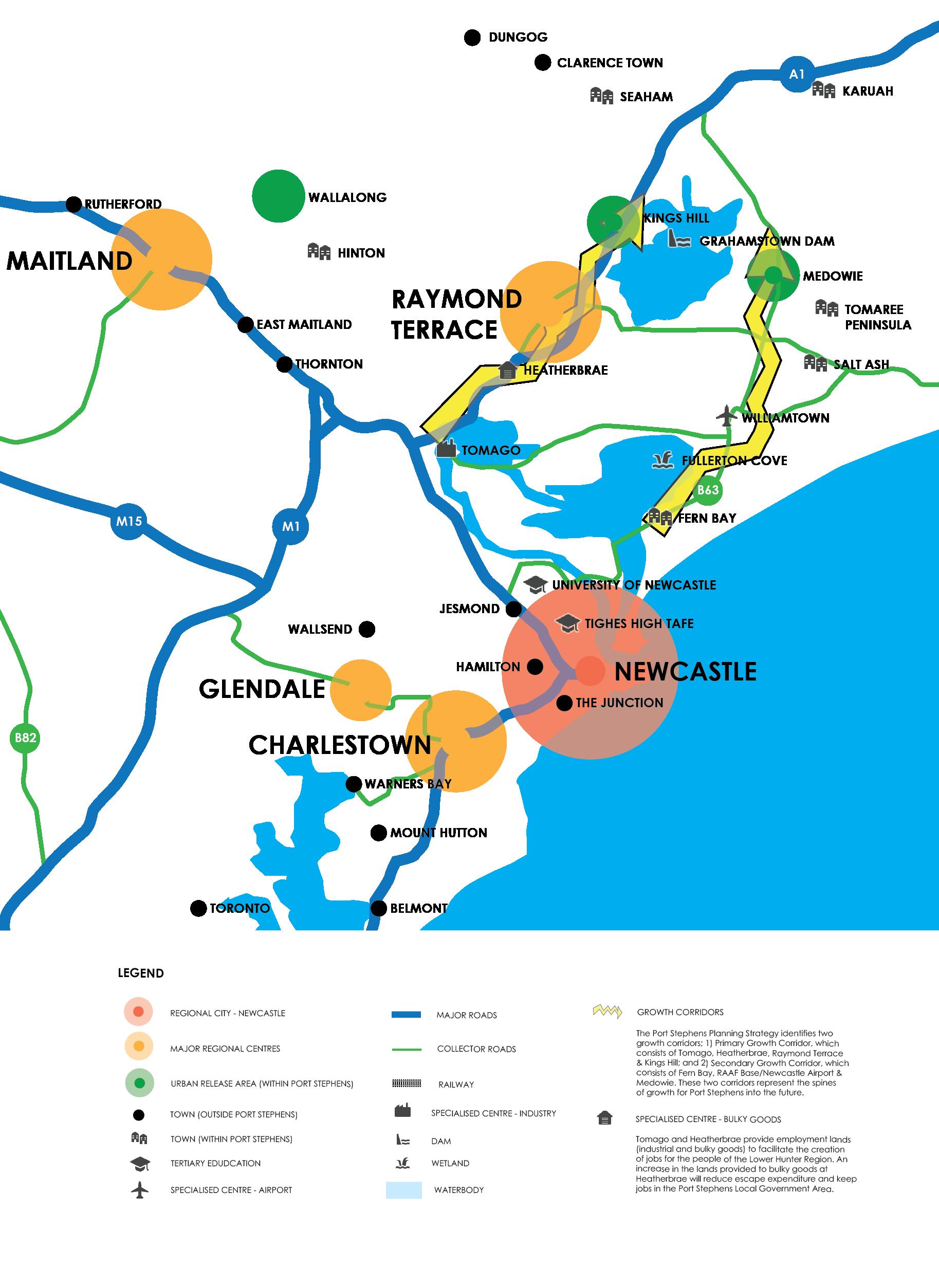
Raymond Terrace has been identified by the NSW Government as one of six major regional centres under the Lower Hunter Regional Strategy (LHRS). The aim of the LHRS is to ensure that the region develops in a strong and sustainable way over a 25 year period to 2031. This means that what happens in Raymond Terrace is not only of importance for the future of Port Stephens, but to the future of the Lower Hunter Valley Region.
This regional centre role is both reflective of histori cal settlement patterns and its proximity to growing centres of employment, such as the RAAF Base Williamtown, Newcastle Airport and the industrial concentration of Tomago. This growth is further illustrated by the residential urban release areas of Kings Hill, which immediately adjoins Raymond Terrace to the north and Medowie, which is 11km to the east. These centres will provide an additional 7,000 dwellings to accomodate19,000 persons by 2031.
Raymond Terrace itself is forecast to accommodate an additional 300 dwellings and 1600 jobs by 2031. This will be provided through infill development and the identification of land to be zoned for business purposes at Heatherbrae. In turn, it is clear that the role of Raymond Terrace is to provide the higher order functions (e.g. court house & speciality retail stores) of a regional centre to not only support its own population growth, but to service the surrounding growth centres.
Signals that both private and public enterprise is responding to this anticipated growth are evidenced by the new GP Super Clinic, NSW Police Local Area Command and Defence Administration Centre, which have all been completed in the past five years When combined with the Port Stephens Council Administration Building, NSW Department of Family & Community Services and major supermarkets, these services all contribute to the regional role of Raymond Terrace in providing those higher order services.
To best accommodate this growth, Raymond Terrace needs a 'strategy'. This strategy needs to outline how to achieve the vision of a strong major regional centre and a great place to live, work and play. It also needs to respond to the core relationships Raymond Terrace has with the Lower Hunter Region as a whole.
The future success of Raymond Terrace and Heatherbrae is believed to be dependent on:
Identifying existing assets, such as the Hunter River that if built upon has the potential to attract investment and visitors
Maintaining its position as the primary commercial centre within Port Stephens
Continued growth of surrounding residential and employment nodes, such as Kings Hill, Medowie, Newcastle Airport and Tomago
Providing key transport links (e.g. vehicular, pedestrian & cycle) between these nodes
Heatherbrae expanding to recoup escape expenditure from bulky goods retail (e.g. hardware and whitegoods)
Raymond Terrace accommodating adaptable and affordable housing due to the concentration of existing community services (e.g. Super Clinic)
Engaging stakeholders, such as local businesses and the active 'place management' (e.g. festivals) of the town centre
Increasing residential density in the town centre
The path towards achieving this vision has been broken down into the following goals:
1. A competitive economy with regional services, including transport, health, justice, government, commercial, retail, industrial and entertainment
2. A city of housing choice with homes that meet needs and lifestyle with a focus on providing for affordable accommodation
3. A great place to live with quality public and private spaces that are accessible
4. A resilient city with clear directions for improved social, environmental and economic outcomes
This strategy is Council's plan to achieve these goals It's an action plan focused on bringing all stakeholders together with a common purpose to make Raymond Terrace a strong major regional centre and a great place to live, work and play. The drivers for growth are evident and therefore planning for this growth has never been more important.
9
THE STRATEGY
Raymond Terrace needs a strategy to achieve its vision as a strong regional centre and a great place to live, work and play. The strategy provides the strategic direction to effectively link broad strategic directions to tangible actions that will be implemented within the life of this strategy.
The strategy is made up of two components; 1) A written component, which is provided as a vision, then a series of goals, directions and actions; and 2) An illustrative component, which is provided as the Key Action Maps (pp. 50 51). The written component is summarised below.
Port Stephens Council's vision for Raymond Terrace is:
VISION: A strong regional centre and a great place to live, work and play
To achieve this vision, Council has set down goals and directions that Raymond Terrace will be:
GOAL 1: A competitive economy with regional services, including transport, health, justice, government, commercial, retail, industrial and entertainment
DIRECTION 1.1: Growing a competitive regional centre by providing lands to strengthen the retail offering of Raymond Terrace and to make Heatherbrae a leading destination for bulky goods (e.g. hardware)
DIRECTION 1.2: Enhancing transport and mode connectivity, including road, public transport, footpath and cycleway connections within Raymond Terrace and Heatherbrae
DIRECTION 1.3: Planning for regional community services to meet the needs of a growing community
DIRECTION 1.4: Raising the profile of Raymond Terrace through a commercial lands strategy/prospectus.
GOAL 2: A city of housing choice with homes that meet needs and lifestyle with a focus on providing for an aging population through seniors living
DIRECTION 2.1: Enabling development that supports compatible land clustering 'like with like' land uses by the identification of key precincts, such as Kangaroo Street for Light Industrial, and Heatherbrae for bulky goods
DIRECTION 2.2: Providing opportunities for affordable housing and seniors/retirement living
DIRECTION 2.3: Council facilitating the development of catalyst sites
GOAL 3: A great place to live with quality public and private spaces that are accessible
DIRECTION 3.1: Improving the quality of existing open space and undeveloped sites
DIRECTION 3.2: Identifying locations for future passive open space.
DIRECTION 3.3: Implementing main street upgrades
GOAL 4: A resilient city with future development integrating heritage, consistency in the public domain and plan implementation
DIRECTION 4.1: Retaining connections to the past through the integration of heritage into new development
DIRECTION 4.2: Developing a streetscape design guideline for consistency of elements in the town centre
DIRECTION 4.3: Establishing an implementation panel to provide continual input.
DIRECTION 4.4 Reinforcing the role of Raymond Terrace as the prominent commercial centre to service the future needs of Kings Hill, Medowie, Tomaree Peninsula and other smaller towns
The pathways provided by these directions are then translated into a key number of actions. These actions are the implementation outcomes of this strategy
10
POLICY CONTEXT
Raymond Terrace is identified as a major regional centre within a number of strategic planning documents and policies. The strategy responds to the strategic directions set in:
The Port Stephens Integrated Planning & Reporting Framework aims to ensure that the agreed direction, aspirations and goals of the community are reflected in Council's planned operations.
National Urban Design Protocol (2011)
Lower Hunter Regional Strategy (2006)
Port Stephens Community Strategic Plan (2014)
Port Stephens Planning Strategy (2011)
Port Stephens Local Environmental Plan (2013)
Port Stephens Development Control Plan (2014)
Port Stephens s94 Contributions Plan (2007)
National Urban Design Protocol
The Urban Design Protocol establishes twelve broadly agreed principles for quality urban places in Australia. These principles can be applied to any project or location, such as Raymond Terrace.
These twelve principles were used to analyse Raymond Terrace and then formulate the goals, directions and actions included in this strategy.
Lower Hunter Regional Strategy
The Lower Hunter Regional Strategy is the NSW Government's 25 year land use strategy for the Hunter Region that seeks to ensure the region develops in a strong and sustainable way.
The strategy is based upon a population growth scenario of an additional 125,000 persons in the Lower Hunter Valley by 2031, and promotes a hierarchy of centres, ranging from Newcastle as a regional city of national importance to six major regional centres, being Charlestown, Glendale/Cardiff, Maitland, Cessnock, Raymond Terrace and Morisset. The strategy identified that Raymond Terrace would accommodate an additional 1600 jobs and 300 dwellings over 25 years.
Port Stephens Local Environmental Plan 2013
The Port Stephens Local Environmental Plan 2013 provides the legislative rules that control building form. This plan was the product of a comprehensive review that came to a completion on 22 February 2014.
A comprehensive review of the development standards, such as building heights as they relate to Raymond Terrace are awaiting the outcomes of this Strategy.
Port Stephens Community Strategic Plan
Figure A: Community Strategic Plan Framework
As illustrated above in Figure A, the role of the Community Strategic Plan is to detail the community's agreed aspirations and needs for the Port Stephens Local Government Area.
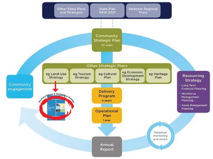
From this, it can be understood that it is the role of strategic plans, such as the Raymond Terrace and Heatherbrae Strategy to directly inform the Delivery and Operational Plan. In turn, it is the role of this Strategy to detail the community's agreed aspirations for the needs of Raymond Terrace and Heatherbrae to then ensure they are provided through the delivery and operation plan.
Port Stephens Development Control Plan 2014
The Port Stephens Development Control Plan 2014 seeks to provide further guidance to the legalise and non descriptive format of the Port Stephens Local Environmental Plan 2013.
The parts within this Development Control Plan that are to be reviewed through this Strategy include D1 Heatherbrae Industrial and D11 Raymond Terrace Town Centre.
Port Stephens s94 Contributions Plan
The Port Stephens s94 Plan, Incorporating Port Stephens, Great Lakes and Newcastle Cross Boundary s94 Plans details the financial contribution required for development. These should be considered as future mechanisms to implement a number of actions included in this strategy.
12
BACKGROUND
The strategy has involved the following key milestones:
Collaborative Community Map Output Report
The Collaborative Community Map Output Report that was completed by ARUP summarises key matters raised by the community through the use of an online community engagement mapping tool.
A density analysis of the key words mentioned resulted in the following top results:
'things I like' playground, trees and park.
'things that I do not like' playground, families, replace, service and need.
'things that are missing' playground, park, river, town, facilities, along, play and need.
Background Paper
The following background studies and community consultation has taken place to develop this strategy.
Business Retention and Expansion Survey Report
The Raymond Terrace Business Retention and Expansion Survey Report is the output of a survey of 84 businesses undertaken to gain an understanding of needs, concerns and opportunities.
The report offered a number of recommendations relating to promotion/profiling, business environment/development, the foreshore/riverfront and Council services.
Economic Land-Use Study
The Economic Land Use Study was completed by Hill PDA to better understand the demand for a range of employment generating uses.
The study offered a number of strategies, such as 'making Heatherbrae a destination for bulky goods'
Transport and Parking Review
The Transport and Parking Review was completed by GHD to develop realistic and achievable transport outcomes for Raymond Terrace with the aims of increasing walking, cycling and public transport.
The transport strategies developed as a part of this review have been incorporated into the strategy
framework and have also been listed as actions, such as Direction 1.2 Enhancing road connections
The background paper forms the first component of this strategy. It was developed to provide a summary of literature and information, such as census data.
This paper provided an overview of baseline data, such as transport, which has fed into the development of this draft strategy.
Discussion Paper
The discussion paper followed the background paper by providing the basis for community discussion with a focus on:
Identifying opportunities for growth
Stimulating discussion and encouraging ideas
Identifying issues that are important
Consultation Summary
The strategy has been developed in coordination with the Port Stephens community. The following key community consultation initiatives were undertaken in the development of this strategy:
Business Retention Survey
Submissions to Discussion Paper & Draft Strategy
Information Stands
Collaborative Mapping Tool s
Surveys and Voting Booths
Council received 20 submissions to drafts, 84 completed business retention surveys, over 230 comments on the collaborative mapping tool , 8 completed surveys and 39 votes on the main street.
13
8.
7. Community
6. Discussion
5. Economic Assessment Study 4. Traffic and Car Parking Study 3. Background Paper 2. Business Retention & Expansion Survey 1. Literature Review
Raymond Terrace and Heatherbrae Strategy
Consultation
Paper
GOAL 1
- A competitive economy with regional services, including transport, health, justice, government, commercial, retail, industrial and entertainment
Photo: Court House, William Street, Raymond Terrace
GOAL 1
A competitive economy with regional services, including transport, health, justice, government, commercial, retail, industrial and entertainment
DIRECTION 1.1: Growing a competitive regional centre by providing lands that strengthen the retail offering of Raymond Terrace and facilitate Heatherbrae as a destination for bulky goods
Raymond Terrace has been identified by the Lower Hunter Regional Strategy (LHRS) as one of six major regional centres within the Lower Hunter Valley Region The LHRS is the NSW Government's 25 year land use strategy for the Hunter Region to ensure it develops in a strong and sustainable way.
The strategy is based on a population growth scenario of an additional 125,000 persons in the Lower Hunter Valley by 2031, and promotes a hierarchy of centres, ranging from Newcastle as a regional city of national importance to the six major regional centres of Charlestown, Glendale/Cardiff, Maitland, Cessnock, Morisset and Raymond Terrace.
This major regional centre role of Raymond Terrace should reflect its strong historical and cultural connections to the river, proximity to the growing centres of employment, such as the RAAF Base Williamtown, Newcastle Airport and the industrial concentration of Tomago and it's close proximity to major national and state road networks.
These growth opportunities are further illustrated by the residential urban release areas of Kings Hill, which immediately adjoins Raymond Terrace to the north and Medowie, which is 11km to the east. These centres will provide an additional 7,000 dwellings to accomodate19,000 persons by 2031.
Raymond Terrace itself is forecast to accommodate an additional 1600 jobs and 300 dwellings by 2031. This will be provided through infill development and some lands zoned for business purposes at Heatherbrae. In turn, it is clear that the role of Raymond Terrace is to provide the higher order functions of a regional centre to not only support its own population growth, but the surrounding growth at Kings Hill and Medowie.
Raymond Terrace
The Hill PDA, 2012, 'Raymond Terrace & Heatherbrae Strategy' identified demand for an additional
45,633m2 (9.4ha) of commercial floorspace within Raymond Terrace by 2031. However, at 5%, Raymond Terrace's vacancy levels are very low and as such there would be limited scope within the centre to accommodate future demand for retail floor space or redevelopment at greater densities.
As a result, it is likely that the 6.0ha of vacant land currently zoned for commercial purposes at the Raymond Terrace Sports Field would be the most likely site to accommodate this growth
The provision of any additional retail floorspace should take into account the following principles:
New retail development, especially at Medowie and Kings Hill should reinforce the role of Raymond Terrace as the key retail hub for the day to day needs of the Region's residents
New retail development should contribute to and improve the vitality and viability of the centre, including existing assets, such as the revitalisation of William Street and the King Street Precinct
New retail development should support improvements to the local transport network and the public domain to provide better pedestrian, cycleway and public transport connectivity
New retail development should provide greater retail choice and competition
This strategy identifies that sufficient commercial lands currently exist in Raymond Terrace and that they be monitored at five yearly intervals to ensure demand does not exceed supply.
Heatherbrae
The Hill PDA. 2012, 'Raymond Terrace & Heatherbrae Strategy' identified an additional demand for 15,000m2 for bulky goods within Heatherbrae by 2031.
The study identified that much of the current demand for bulky goods is being met by stores outside of the Local Government Area (LGA), such as those at Rutherford, Thornton, Kotara and Warners Bay. Whilst all of the growth in demand for bulky goods floorspace does not need to be located within the LGA, there are substantial benefits from accommodating more bulky goods floorspace locally, including:
generating employment
reducing the need for residents to travel
15
capturing expenditure from other locations to the benefit of business in the LGA
Furthermore, the planned M1 Pacific Motorway bypass of Heatherbrae and the additional residential population planned at both Kings Hill and Medowie, places Heatherbrae in a position to evolve from a destination that caters to passing traffic to become a destination in itself, catering for the needs of the growing residential population.
In turn, Heatherbrae lends itself to becoming a 'destination for bulky goods' as it demonstrates characteristics that bulky goods retailers prefer:
The following actions seek to strengthen the retail offering of Raymond Terrace and make Heatherbrae a key destination for bulky goods premises.
Actions
1. Monitor the supply of B3 Commercial Core and IN2 Light Industrial lands in Raymon d Terrace as part of the review of the Port Stephens Planning Strategy and then on an annual basis once the commercial strategy/prospectus has been developed the need for a commercial strategy is identified as Action No.14.
Large and extensive trade area
Central position within a trade area Cheap and substantial land to enable plentiful parking and loading/unloading facilities Location on a major road with high visibility Expanding trade area as new homes generate higher demand than established homes
From the above, the only characteristic that Heatherbrae may be lacking is affordable land due to the difficulties in sourcing, assembling and purchasing lots of sufficient size to cater for floorspace, parking and access requirements. This is why the strategy proposes to identify lands on the western side of the Pacific Highway for bulky goods premises (Figure M, p. 51). This land has primarily been maintained in large land ownership due to past agricultural pursuits and has excellent exposure from the Pacific Highway which will continue beyond the proposed Heatherbrae bypass.
Bulky goods retailers such as Masters have recently responded to these favourable characteristics by establishing on the eastern side of the Pacific Highway at Heatherbrae. In supporting Heatherbrae into becoming the key 'destination for bulky goods', any proposals outside of existing centres would need to be carefully considered. This is based on the importance of clustering bulky goods in one location for their long term viability.
Heatherbrae has been identified as the most suitable location for bulky goods premises from the following studies:
Hill PDA. 2012, 'Raymond Terrace & Heatherbrae Strategy'
Leyshon Consulting. 2011, 'Review of Bulky Goods Floorspace Demand Study'
2. Identify 4.5ha of B5 Business Development on the western side of the Pacific Highway to facilitate Heatherbrae as a 'key destination for bulky goods'. The most suitable sites have been identified as the following:
2253 Pacific Hwy (Pt Lot 62 DP 578367)
2259 Pacific Hwy (Pt Lot 1 DP 836879)
2249 Pacific Hwy (Lot 1 DP 161865)
SGS Economics. 2010, 'Port Stephens Commercial and Industrial Lands Study'
2273 Pacific Hwy (Pt Lot 2 DP 1113232)
2265 Pacific Hwy (Pt Lot 1 DP 1113232)
3. Promote catalyst sites for commercial development that will underpin William Street as the main street of activity catalyst sites are discussed as Action No.26
DIRECTION 1.2: Enhancing transport and mode connectivity, including road, public transport, footpath and cycleway connections within Raymond Terrace and Heatherbrae.
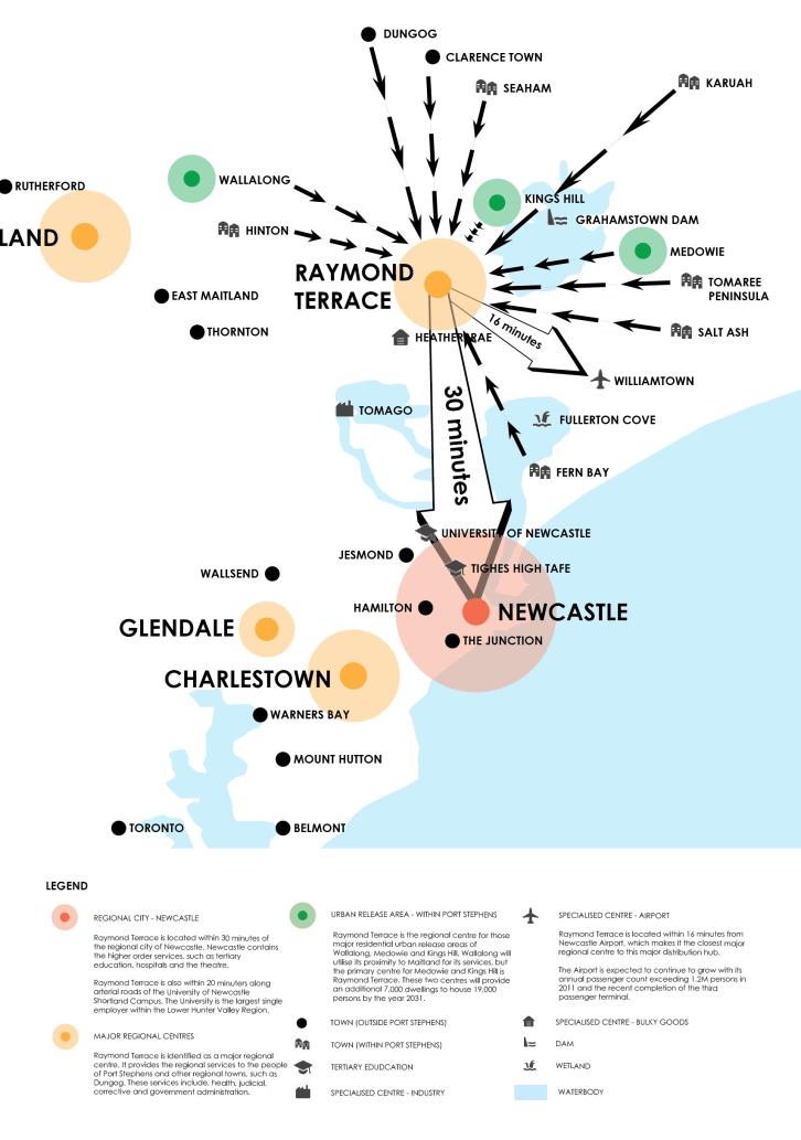
Raymond Terrace has strong connectivity to surrounding centres via major arterial roads. It is within 30 minutes of Newcastle, 25 minutes of Maitland and 16 minutes of Newcastle Airport. Its connection to Newcastle is via the Pacific Highway, which is the major arterial road along the East Coast of Australia.
Maintaining and improving connections both within and between other centres is a key attribute in the facilitation of a competitive economy, as it is accessibility to places of interest, such as jobs and entertainment that is a key contributor to land value.
Raymond Terrace
The road network within the Raymond Terrace town centre is reflective of a traditional 'gridiron' street pattern. The GHD. 2011, 'Raymond Terrace Transport and Parking Review' identifies a list of improvements to complete this grid network to improve connectivity.
17
These improvements will not only increase connectivity for vehicular movements, but stimulate further redevelopment within the town centre. These key improvements are to take place through the redevelopment of certain lots and/or the acquisition of land by Council, they include:
Port Stephens Street and Seaham Road, which connects Dungog and Maitland to Raymond Terrace
Richardson Road, which connects the Tomaree Peninsula and Medowie to Raymond Terrace
Bourke Street is extended from Adelaide to Port Stephens Street to continue the grid like network Carmichael Street is extended from the existing cul de sac to Bourke street
Reconfiguration of the Bourke Adelaide Street intersection to be signalised to allow full turning movements, including right turn from Adelaide St
Connectivity does not just relate to private motor vehicles, but also to public and active transport modes, provided in the form of buses, rail, cycleways and pedestrian access. Rail is not a significant player in the Hunter Region. Historical connections exist between places such as Maitland and Newcastle and between Newcastle and Sydney. Public buses are therefore the dominant form of public transport to travel to/from and within Port Stephens
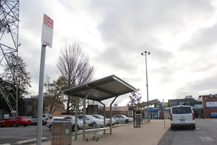
For many, Raymond Terrace is the key location for these regional services. Pick up and drop off locations along Adelaide Street allow commuters to catch a regional bus service to locations such as Sydney and Nelson Bay A new multi transport hub located off 'The Close' now also provides an accessible location for commuters to wait for taxi services.
Raymond Terrace and Heatherbrae also have a network of pedestrian and cycle tracks that connect suburbs within Raymond Terrace to other towns, such as Medowie. Paths have also been identified to provide future connections to the urban release area of Kings Hill.
However, some of these existing connections are incomplete, while other connections could be improved to increase their accessibility for the disabled. A key role of the strategy is to identify those incomplete links or those in need of improvement by identifying the need to update and implement the Port Stephens Council, 2015, 'Draft Pathways Plan'
The key links to/from Raymond Terrace to those towns that utilise this Regional Centre for its services include:
Newline Road, which connects the urban release area of Kings Hill to Raymond Terrace. The intersection of NewLine and Seaham Roads will need to be upgraded as Kings Hill develops
Masonite Road, which connects Newcastle Airport to Raymond Terrace and Heatherbrae
Pacific Highway and Adelaide Street, which connects Newcastle and Sydney to Heatherbrae and Raymond Terrace
Figure B: Raymond Terrace Identification of regional road connections and suburbs illustrates some of these key connections into Raymond Terrace.
Photo: Multi Transport Hub, Raymond Terrace Heatherbrae
The Pacific Highway has been continuously upgraded and is now a separated dual carriageway from Heatherbrae to Port Macquarie.
The existing road between Raymond Terrace and Newcastle is not dual carriageway, but generally consists of dual lanes that have a number of pinch points, such as the Hexham Bridge. This creates an opportunity for the continuation of the dual carriageway from Heatherbrae. The Port Stephens Council, 2011, 'Port Stephens Planning Strategy' has forecast that this section of the Pacific Highway will increase from 39,258 vehicles in the year 2005 to 131,769 vehicles in the year 2031.
One of the key components of this strategy is to prepare Heatherbrae for the potential M1 Pacific Motorway extension and realignment. Critical to this will be effective connections to improve connectivity and safety, while providing opportunities for Heatherbrae to evolve from a highway service centre.
Connections to Heatherbrae from Medowie, Kings Hill and some eastern parts of Raymond Terrace will be
18
Figure B : Raymond Terrace Identification of regional road connections and suburbs

19
via the Pacific Highway. Ensuring that Heatherbrae can transition into a destination for bulky goods is dependent on the connections to and from what will be the old Pacific Hwy to be classified as a local road.
It is suggested that either Roads & Maritime Services or Council prepare a traffic analysis/management plan to assist in understanding the traffic environment post highway. This analysis would facilitate the rezoning of those lands identified for bulky goods premises and ensure a safe and efficient relationship with the new Heatherbrae bypass. In addition, both Roads & Maritime Services and Council need to prepare a coordinated approach to this informal access to ensure the safety of road users.
Raymond Terrace also has a number of roads that exist on paper, but have never been sealed. They will not be required for the future traffic network and in turn it is proposed that they be earmarked for closure and consolidation. These roads include two roads within Riverside Park and a road that is within the Raymond Terrace Trotting Track. Once survey work is completed it is proposed that they be consolidated with the adjoining Crown Land.
Actions
4. Identify ‘missing road links’ within the site specific Development Control Plan for Raymond Terrace and Heatherbrae.
5. Finalise the construction and maintenance of the multi transport hub at 'The Close'
6. Update and Implement the Raymond Terrace Pedestrian & Cycle Strategy. Complete priority links and advocate for connections to the wider network, such as from Raymond Terrace to Newcastle and Maitland
7. Support future proposals for increased public transport from Port Stephens
8. Advocate for the southern interchange of the Heatherbrae Pacific Motorway bypass to provide northern access to Heatherbrae.
9. Undertake a detailed traffic analysis/management plan to determine the future traffic environment of Heathbrae. This analysis will also identify opportunities for improved accessibility to support additional lands for bulky goods premises. Timing of this is subject to the finalisation of the Heatherbrae Bypass Plan.
10. Address the informal access arrangements that have been created over 'community land' as defined under the Local Government Act 1993
for businesses with direct access to the Pacific Highway
11. Consolidate portions of roads within Riverside Park and the Trotting Track into the adjoining Crown Land Reserves.
DIRECTION 1.3: Planning for regional community services to meet the needs of a growing community
Raymond Terrace has existing community infrastructure, which is referred to by town planners as 'social infrastructure'. This social infrastructure is the human capital and the institutions that capitalise it, such as schools, police stations or hospitals
Raymond Terrace has the following existing community infrastructure:
Raymond Terrace General Practice Super Clinic
NSW Police Local Area Command
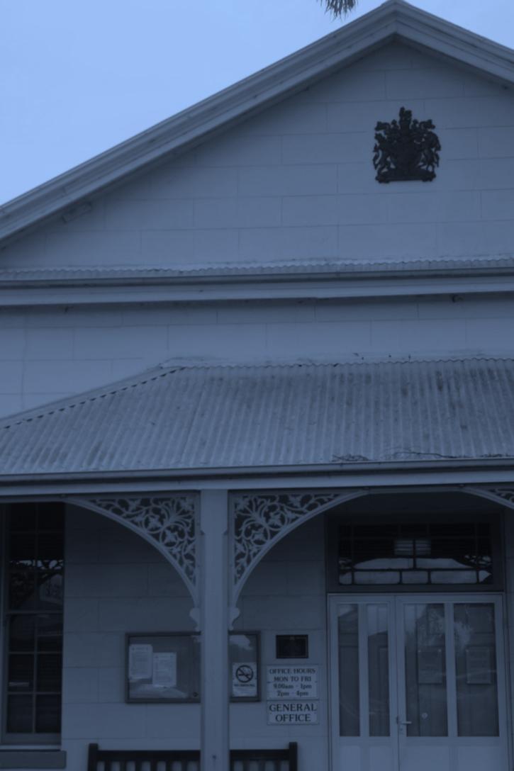
Raymond Terrace Court House
Department of Family & Community Services
Port Stephens Council Administration Building
Defence Administration Centre
Schools, both primary and secondary
Places of public worship, such as churches
Roads & Maritime Services Building
While Raymond Terrace has an increasing amount of community infrastructure with the completion of the GP Super Clinic in 2014 and the NSW Police Local Area Command in 2012 it still has the potential to expand its provision of community infrastructure in other spheres, such as education. It could leverage off its close geographical connections to the University of Newcastle, Tighes Hill TAFE and other senior colleges in Newcastle to provide not only regional education services for Port Stephens, but as a satellite location for these services to Newcastle.
For example, Raymond Terrace is located within 20 minutes of the University along a major arterial road. It
20
Figure C: Raymond Terrace Draft Pathways Plan
21
Figure D: Heatherbrae Draft Pathways Plan
22
has a plentiful supply of affordable land in close proximity to existing infrastructure and services. The University or private accommodation providers could seek to capitalise on this availability. This approach of marketing Raymond Terrace to major service providers could also be applied to private or other government services. Raymond Terrace is the closest regional centre with the highest concentration of existing commercial and industrial floor space to Newcastle Airport. The existing 681,419sqm of existing industrial and business floorspace supply and its B3 Commercial Core is reflective of this regional role.
The closest alternatives to the Airport include Maitland, which is within 34 minutes and the Newcastle CBD, which is within 30 minutes. Passengers at Newcastle Airport exceeded 1.2M in 2011 and this is forecast to continue to grow with the recent completion of the third passenger terminal.
Raymond Terrace must continue to reinforce its role as the major centre, not only for the placement of social infrastructure services for Port Stephens, but also in its role as being the closest centre to the growing Newcastle Airport and to cater for overspill from the growth of the regional city of Newcastle.
Actions
12. Advocate for Raymond Terrace amongst major institutions, such as the University of Newcastle about the availability of affordable land and key catalyst sites both in Council and in private ownership. Catalyst sites and those with subdivision potential have been identified under Action No.24
13. Recognise the role in providing services to those smaller surrounding centres, such as Medowie, Dungog, Kings Hill and Salt Ash through providing a more detailed audit of community services than what is provided under Action No.1 in the review of the Port Stephens Planning Strategy.
DIRECTION 1.4: Raising the profile of Raymond Terrace through an economic and commercial strategy/prospectus
The profile of Raymond Terrace as a liveable major regional centre is understated within the Lower Hunter Region. The Hill PDA.2012, 'Raymond Terrace & Heatherbrae Economic Study' identified retail as the highest employer within Raymond Terrace.
Raymond Terrace has approximately 135,000sqm of occupied floorspace. Retail trade comprises 61% of this total occupied floorspace. The town centre also
compromises a relatively significant amount of financial, insurance, professional and government services. Raymond Terrace is also expected to experience a population growth of an additional 8,034 people by 2031. This growth will largely be accommodated by the development of the Kings Hill Urban Release Area. Challenges associated with this forecast population increase include:
• Increasing demand for retail and services
• Attracting office development and workers
• Increasing the provision for health and community services
Conversely, Raymond Terrace has significant opportunities for growth based on a better utilisation of the following qualities:
• River frontage
• Close connections to Newcastle and the Airport
• Availability of affordable land
• Walkable town centre
• Traditional retail main street
• Existing sporting fields and facilities
• Connections to Pacific & New England Highways
• Untouched heritage, such as King Street
• Place making opportunities
These qualities are reflective of a number of good urban design attributes, such as a short main street. The 'Main Street' of Raymond Terrace, being Williams Street is 480m in length from Adelaide to King Street. This is close to an ideal length for walkability and the appreciation of human scale.
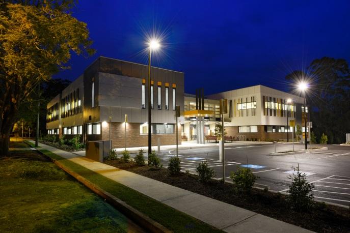
Photo: GP Super Clinic, Jacaranda Ave
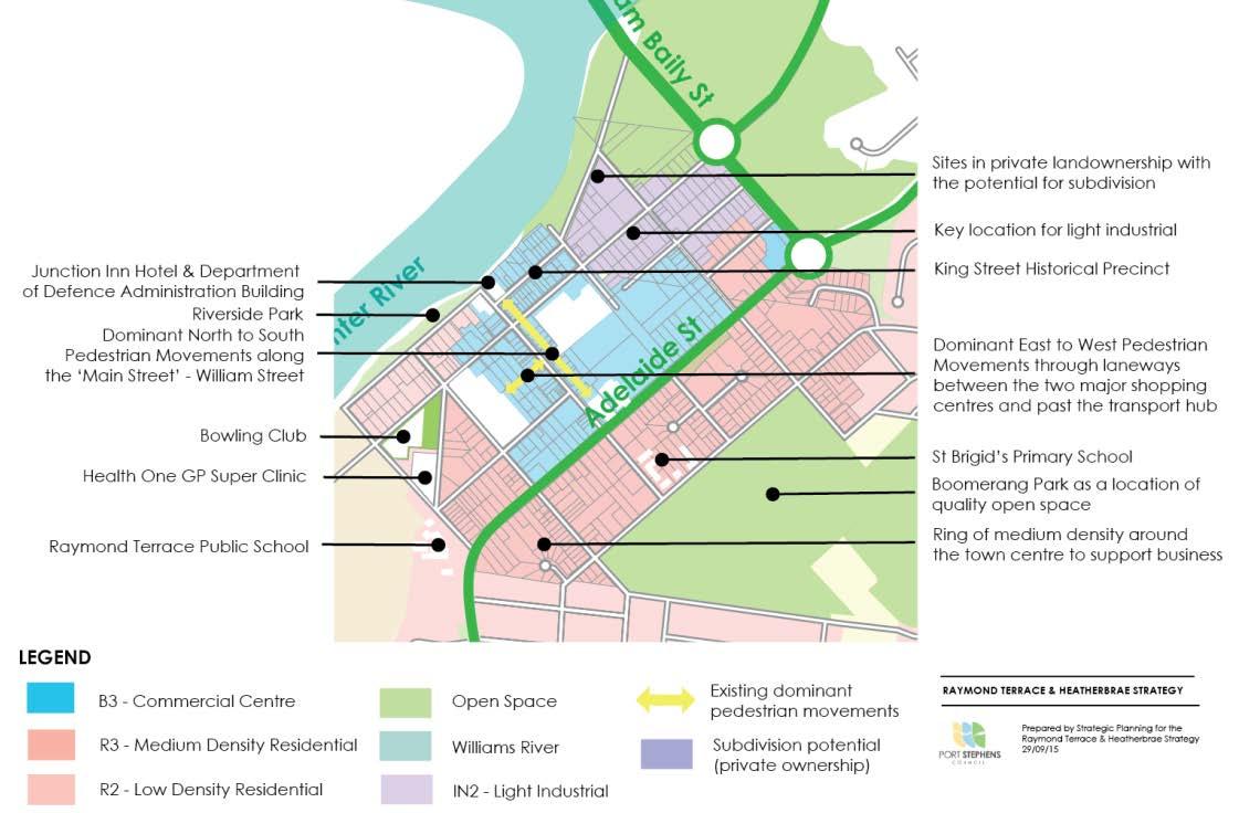
This main street also receives excellent cross direction flows between the two major shopping centres of Raymond Terrace Marketplace and Terrace Central as illustrated in Figure E: Raymond Terrace Identification of land use zones, sites with subdivision potential and landmark buildings This favourable
23
environment means that the street continues to evidence high occupancy rates despite the aging state of a number of the buildings.
Port Stephens Council through its economic development Unit and in consultation with key stakeholders should seek to promote the availability and attractiveness of employment lands (commercial and industrial) not only in Raymond Terrace, but across Port Stephens.
It could seek to provide this promotion through the development and maintenance of a commercial strategy that acts as a prospectus. This strategy would incorporate the discussion of both long term and emerging trends in the supply and demand for lands. It would incorporate data relating to land take up, site coverage and employment agglomerations.
The economic and commercial strategy would expand on the Hill PDA. 2012, 'Raymond Terrace & Heatherbrae Economic Study', specifically Chapter 12. It will provide a framework for growth and seek to enact the vision for Raymond Terrace as a vibrant and liveable town centre, Heatherbrae as a destination for bulky goods, the Tomaree Peninsula for tourism and lands around Williamtown Airport for airport related uses. It would maintain up to date data integrated with planning requirements to allow private investors to make well informed decisions about the purchase and development potential of employment lands.
Actions
14. Develop an economic/commercial strategy/prospectus that promotes land availability and its development potential, which will:
Assist landowners in understanding the development potential of their land under the planning framework
Provide prospective developers with an understanding of the precincts and business agglomerations present within Port Stephens
Provide current data (i.e. planned infrastructure investments, approved development types, etc.) ideally via an online medium
Incorporate data regarding broad market parameters from the Property Services Section of Council
Promote and describe the attributes of key landmark sites, which may either be in Council or private ownership
Follow examples such as the Wollongong City Council. May 2014, 'Wollongong Investor Prospectus' or the Lake Macquarie City 'Love the Lake'
24
E : Raymond Terrace Identification of land use zones, sites with subdivision potential and landmark buildings
25
Figure
GOAL 2
- A city of housing choice with homes that meet our needs and lifestyles with a focus on providing for affordable accommodation, which includes seniors living and student accommodation
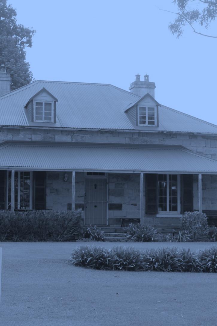
Photo: Cadell Cottage (Former Doctor's House), Hunter Street, Raymond Terrace
GOAL 2
- A city of housing choice, with homes that meet our needs and lifestyles with a focus on providing for affordable accommodation, which includes seniors living and student accommodation
DIRECTION 2.1: Enabling development that supports compatible land clustering 'like with like' land uses by the identification of key precincts, such as Kangaroo Street for Light Industrial, and Heatherbrae for bulky goods.
The planning framework as it relates to development standards, such as height, has been updated as part of the adoption of the Port Stephens Local Environmental Plan 2013 on 22 February 2014.
The strategic justification for these local environmental plan amendments was provided by the by the Port Stephens Council, 2011, Port Stephens Planning Strategy, which is underpinned by the NSW Government. 2006, Lower Hunter Regional Strategy'. The PSPS identifies the following for Raymond Terrace and Heatherbrae:
Heatherbrae has been identified as the key location for bulky goods retail in the Local Government Area. Repositioning of this area for this purpose will be facilitated by the development of the Raymond Terrace/Heatherbrae Growth Strategy (this strategy), which will see an increase in demand for additional employment generating lands The Raymond Terrace town centre is affected by the flooding of the Williams and Hunter Rivers The Kangaroo Street Precinct is retained for local light industry.
The river outlook is an underutilised asset
The key land use legislative changes for Raymond Terrace resulting from the Port Stephens Local Environmental Plan 2013 included:
will gain greater means to achieve higher density objectives by increasing the permissible height. This will ensure consistency across other locations zoned R3 Medium Density Residential within the Port Stephens Local Government Area.
Further legislative and regulatory changes that are proposed by this Strategy will be based on the following planning principles:
The town centre has sufficient supply of commercial land and a number of locations on its periphery with existing use rights for commercial purposes, such as the land opposite Raymond Terrace Public School and on the corner of Bourke & Adelaide Streets. The strategy will seek to consolidate commercial activities that are focused around William Street Reinforce William Street as the main retail precinct and ensure the strong north to south pedestrian directional flow that is provided by the two major shopping centres
Placing a perimeter of R3 Medium Density Residential around the town centre. Reducing the boundaries of the B3 Commercial Core to a defined area of the town centre
Reserving land at Heatherbrae for the Pacific Highway bypass
This strategy now seeks to compliment these zoning changes with development standards. For example, the medium density zoning around the town centre
Encourage higher residential density in the town centre to provide support for business by increasing building heights for the land zoned R3 Medium Density Residential and zoned B3 Commercial Core around the town centre.
Focus industrial and commercial lands to the western side of the Pacific Highway and do not allow further development in the green corridor beyond the approved Kinross Industrial Estate within the life of this strategy
Identify sites that are both suitable for infill and new land release residential development
27
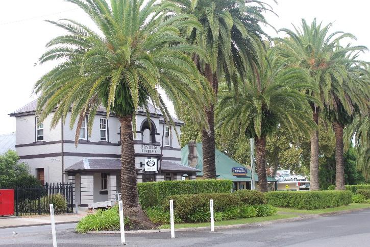
Photo: Phoenix Palms, Port Stephens St
Ensure commercial development provides activation to existing and proposed streets rather than resulting in introverted private spaces
Provide quality open space over quantity of open space. This is consistent with the best practice approach detailed in the Landcom. 2008, 'Guidelines for Open Space Design' Capitalise on the riverside setting by providing better connectivity with the river foreshore for improved pedestrian access and recreational activities.
The following actions seek to achieve these planning principles. This approach is also supportive of the identification of a key number of precincts, such as:
William Street as the main street of activity and the centre of town centre services
R3 Medium Density Residential around the town centre as the key location for increased densities to support commercial services
Boomerang and Riverside parks as key locations of quality open space
Heatherbrae as the destination for bulky goods King Street as the historical precinct North East of the town centre as the key location for light industrial services
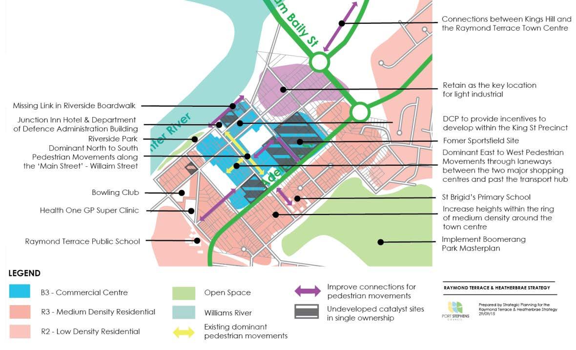
These precincts as illustrated by Figure F: Raymond Terrace Identification of key precincts, catalyst sites and key pedestrian connections are not explicitly defined, but rather seek to provide strategic justification to guide the inclusion or exclusion of permissible development types in each zone. The role of the strategy is therefore to provide strategic justification and provide answers when questions are asked of the regulatory framework, such as:
Why should commercial development be focused around William Street? The location of key anchors, such as Woolworths and the Defence Administration Building on William Street provides support to surrounding retail, which in turn increases the interest for other businesses, such as offices or accommodation to locate within the town centre. Allowing large scale retail outside of the town centre undermines the ability to provide support to these speciality stores.
development, such as highway exposure and in turn the strategy should support the benefits of agglomerations by focusing this type of development to this one location.
Why should developable land be currently contained to the eastern side of the planned Heatherbrae bypass? The allocation of land for the planned Heatherbrae bypass has resulted in industrial land at Heatherbrae being split in half. As a result, a small residual parcel exists on the eastern side, which forms part of the Kinross Industrial Estate. Given the significant supply of industrial land at both Heatherbrae and Tomago , it would be appropriate to not zone further lands for industrial purposes. This approach ensures that development is, on the most part, retained to the western side of the proposed by pass and the Watagan Stockton Green Corridor, as identified under the Lower Hunter Regional Strategy, is not incrementally encroached by development. At the same time, it would be logical that if further general industrial lands are required that this be an extension of Kinross Estate. As such, potential future expansion to the existing industrial area is identified for long term investigation through reference to Figure M: Key Action Map: Heatherbrae.
Why identify locations with potential for infill and Greenfield development within Raymond Terrace? The Lower Hunter Regional Strategy identifies that Raymond Terrace itself is forecast to accommodate an additional 1600 jobs and 300 dwellings by 2031. These small dwelling targets are reflective of the fact that Greenfield development will occur at Kings Hill and Medowie, while dwellings within Raymond Terrace itself will be achieved by infill development. The strategy identifies a site at the end of Speedy Lock Lane and those sites within the town centre with current subdivision potential will be used to achieve these targets. Additional sites will also be identified through the implementation of the actions outlined below.
Actions
Why should bulky goods development be focused at Heatherbrae? Bulky goods development becomes more viable when located in close proximity to other bulky goods development. Heatherbrae displays the characteristics that are sought by such
15. Investigate options to increase the maximum height of building from 9 to15 metres at locations zoned R3 Medium Density. Residential and B3 Commercial Core within the town centre to support opportunities for increased density.
28
16. Support the improvement of quality open space within Raymond Terrace and contribute to the target of 300 dwellings by implementing the Boomerang Park Masterplan
17. Insert the standard instrument clause for activated street frontages into the Port Stephens Local Environmental Plan 2013 and identify where development is to provide activated street frontages within the town centre to facilitate street activation
18. The Department of Defence Administration Building is to provide a boardwalk/path along the Hunter River as part of their existing condition of consent. Council is to work with the property owner to finalise this portion of the boardwalk
19. Identify a portion of land at the end of Speedy Lock Lane, Heatherbrae, known as Lot 173 DP 808771 from RU2 Rural Landscape to R2 Low Density Residential as a potential site for Greenfield development to assist in achieving the housing targets as identified for Raymond Terrace under the Lower Hunter Regional Strategy
20. Monitor the subdivision of lots within the town centre as a part of the review of the Port Stephens Planning Strategy and facilitate discussions with developers for ways in which Council can assist in achieving density for those locations zoned R3 Medium Density Residential, such as reduced parking requirements. An excellent forum to achieve this is provided by the Port Stephens Council Industry Reference Group (IRG)
21. Facilitate and encourage shop top housing within the town centre through ensuring the regulatory framework caters for this development type
22. Review/Audit of future potential residential sites through the review of the Port Stephens Planning Strategy (PSPS)
DIRECTION 2.2: Providing opportunities for affordable housing and seniors/retirement living
Compared to the NSW median, residents in Raymond Terrace have a smaller mortgage and use a smaller portion of their household income to service it.
According to the 2011 ABS Census the median monthly mortgage was $1,517 in Raymond Terrace compared to the NSW average of $1,993.
This data, which is reflective of housing affordability is also reflected in the median house price, which is
$274,000 compared to the NSW average of $415,000. When this is coupled with forecasts that persons over the age of 60 will make up more than 30% of the population by 2031, it begins to be understood that Raymond Terrace lends itself to providing affordable housing, such as seniors living and/or student accommodation.
This aging population presents a major opportunity for Raymond Terrace as it is well positioned to become an innovative leader in the implementation of adaptable housing and aged care accommodation. Integration of diverse housing types provides significant social and economic benefits. Housing options to be explored may include seniors living accommodation and aged care accommodation. Sites in and around the centre of Raymond Terrace have many attributes required for this kind of affordable accommodation, including:
Close proximity to services, such as shops, business and medical facilities which is important for not only health reasons, but also social well being. Housing for older persons should be located within reasonable walking distance of a town centre (ie 200 400m)
A safe walking environment that is level (or has a modest gradient) both on the site and to services/centres. Increasingly sites or locations suitable for use by scooters (ie low gradient, wide paved footpaths) is required to accommodate these movements and enable independence Pleasant surroundings with access to a range of outdoor and indoor recreation/leisure facilities
Access to existing sewerage, electricity and reticulated water services along with adequate road and transport services
The preference for seniors living and affordable housing is illustrative of the trending demographic
29
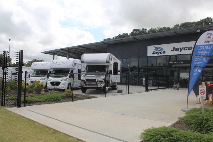
Photo: Jayco Regional Headquarters, Heatherbrae
data, the availability of affordable land, existing social infrastructure and services.
When these characteristics are coupled with the proximity of Raymond Terrace to Newcastle (30 minutes) and Newcastle Airport (15 minutes) there is an opportunity for growth The strategy could seek to facilitate this role for Raymond Terrace as a destination for affordable housing/retirement through the following actions.
Actions
23. Explore legislative and regulatory framework for further possible mechanisms to achieve small lot housing within the zone R3 Medium Density Residential under the Port Stephens Local Environmental Plan 2013
24. Similar to Action No.12, liaise with the University of Newcastle or private accommodation providers to promote Raymond Terrace as a location with affordable land, existing services and accessibility to the Lower Hunter Region.
DIRECTION 2.3: Council facilitating the development of catalyst sites
Over the past decade or so, Council has sought to purchase as part of its operational property portfolio sites for a variety of reasons (eg consolidation of open space). Within Raymond Terrace, the focus has been on purchasing key sites, consolidating and for marketing to potential purchasers.
This is a common approach to the redevelopment of key sites where the 'state' of the land simply makes redevelopment unrealistic for a private party. Examples include the remediation and redevelopment of Honeysuckle in Newcastle and Sydney Harbour through both state and federal funds, such as the Building Better Cities Program.
Although Raymond Terrace is on a much smaller scale, the economics of redevelopment still holds true and in turn Council has acquired a number of strategic sites in and around the town centre.
One of the roles of this strategy is to identify these sites, which include the following:
North side of King St 8,000sqm
Raymond Terrace Sports field Site 35,000sqm
Bourke St Extension 14,000sqm
Corner of Glenelg & Port Stephens St 2,000sqm
Corner of Adelaide & William St 12,000sqm
The strategy will seek to facilitate the development of these key sites through the following action.
Actions
25. Ensure the commercial strategy/prospectus under Action No.14 incorporates these sites and places a detailed emphasis on their most suited use and potential.
The purpose of this process is to reduce the obstacles that that would otherwise render the project unfeasible for a private developer. Council in its governance role then promotes these as catalyst sites for development.
30
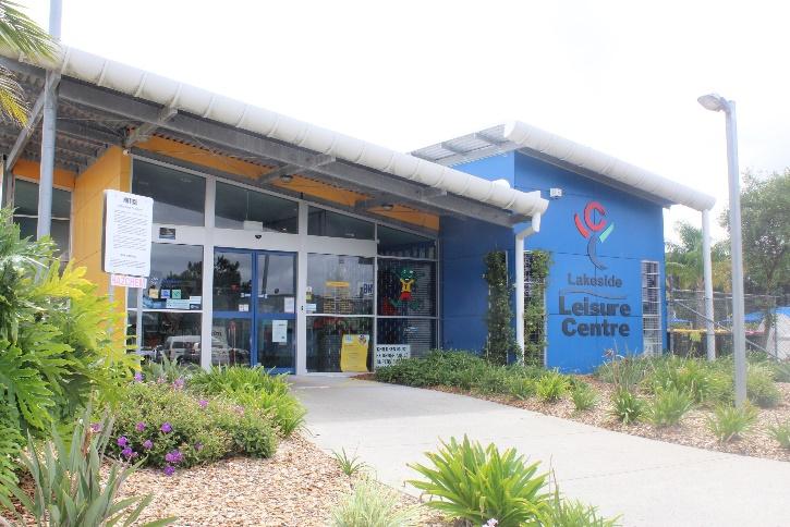
Photo: Lakeside Leisure Centre, Raymond Terrace
Photo: Newcastle Airport, Williamtown
Figure F: Raym ond Terrace Identification of key precincts, catalyst sites and key pedestrian connections

31
GOAL 3
- A great place to live with quality public and private spaces that are accessible
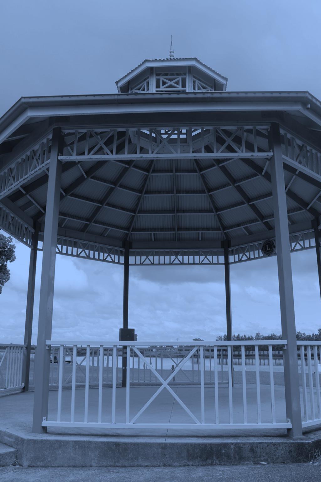
Photo: Rotunda, Riverside Park, Hunter Street, Raymond Terrace
GOAL 3
DIRECTION 3.1: Improving the quality of existing public open spaces and undeveloped sites
Quality open public spaces that are aesthetically pleasing, safe and inclusive for a diverse range of users have a significant effect on the way communities function. These factors determine how liveable a city is and ultimately who wants to invest here, who wants to visit and how long they stay.
Raymond Terrace contains pockets of public open spaces for both active and passive needs. This open space is in both public and private ownership and includes:
Boomerang Park King Park Sporting Complex Jack Johnson Trotting Park Riverside Park Muree Golf Course Bettles Park Botanic Gardens Lakeside Park and Sporting Complex Kittyhawk Park
Figure G: Raymond Terrace Open Space, Passive Open Space Options and Main Street Upgrades illustrates these locations. The Port Stephens Strategic Asset Management Plan 2015 2025 identified the following 'service levels' based on 2006 census data for key items.
These figures illustrate that Raymond Terrace exceeds the cited benchmarks for both active and passive open space and other community infrastructure.
Open space serves an important role in the promotion and encouragement of healthy lifestyles for both residents and visitors. When coupled with a traditional preference for detached housing on large lots, Raymond Terrace has vast amounts of open space in both private and public ownership. Consistent with the Landcom. 2008, 'Open Space Design Guidelines', a quantity to quality approach is desired by Council.
This quantity to quality approach is evident through the open space review that was completed in 2007 and led to the reclassification and rezoning of several sites across Port Stephens. More recently this has been
Item Benchmark Current
Libraries 1 branch library per 20,000 people
1 Raymond Terrace Library Exhibition Space 1 per 30,000 people 2 Raymond Terrace Library and Council Administration Building
Parks & Reserves 0.4ha per 1,000 persons 3.767Ha per 1,000 persons Play grounds 1:366.6 ratio to no. children 1.075 ratio to no. children Leisure Centre 1 per 17,500 persons 2 Lakeside Leisure Centre & YMCA Raymond Terrace Sporting Fields Merits based approach 9 King Park Sporting Complex & Lakeside Leisure Centre
Netball Courts 1 per 3,000 persons 10 King Park Sporting Complex Skate Park 1 per 4,000 persons aged 5 24 years
1 Former Raymond Terrace Sports field Tennis Courts 1 per 1,800 persons 8 King Park Sporting Complex
evidenced by the Boomerang Park Masterplan. This approach recognises the limited operating budgets of regional Councils and si gnificant amounts of open space that they are required to maintain due to poor past open space acquisition.
The strategy will seek to implement this quantity to quality approach in Raymond Terrace through the following actions.
Actions
26. Implementation of the Boomerang Park Masterplan which includes quality paths, play equipment, etc. This is subject to securing appropriate funding.
27. The Streetscape Design Guideline, which is proposed under Action No.36 is to take into account urban design elements, such as what trees and/or vegetation would be most appropriate for open spaces
28. Explore possibilities for the activation of undeveloped sites, such as those sites identified as 'catalyst sites' For example, the former Raymond Terrace sports field regularly
33
- A great place to live with quality public and private spaces that are accessible

34
Figure G: Raymond Terrace Open Space, Passive Open Space Options and Main Street Upgrades
hosts visiting circuses. While the site on the corner of Adelaide and William Streets could host pop up stalls to bring people into the town centre. Examples of activities that are successful in other towns include:
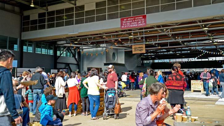
'The Forage' is a showcase of street food by local cafes, food trucks, wineries, designers and breweries in Canberra. It rotates between sites throughout the year to provide activity to underutilised sites and provide a market for small businesses, such as food trucks.
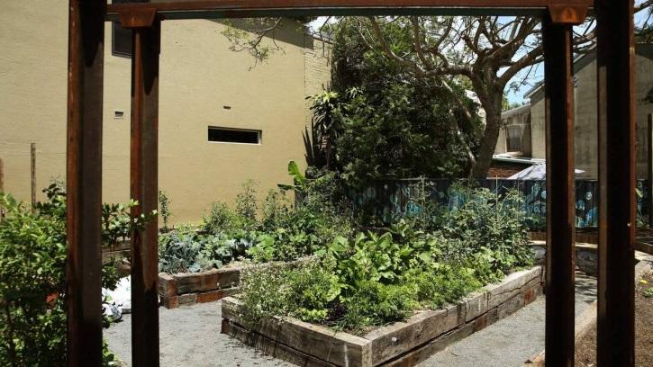
Community gardens have grown in popularity through the refocus on the educational and environmental benefits of locally grown food. Community gardens provide temporary or permanent activation to underutilised sites. The Darby Street Community Garden is an excellent example in Newcastle that has come to fruition through council and community involvement.
The 'King Street' Heritage Festival hosted in April 2015 included a dress up photo booth, weaving demonstrations, live music and market stalls. It was a celebration of the history and future of this historical precinct

During the public exhibition of the Raymond Terrace and Heatherbrae Discussion Paper the community identified a shortfall of passive open space within the town centre. Active open space within the town centre is present at both the northern end (ie Riverside Park) and the southern end (ie Boomerang Park) of Raymond Terrace, but not within its centre.
Active space allows for organised and formal sporting activities and includes sports fields, ovals, outdoor hard courts (e.g. netball), tennis, showgrounds and generally all outdoor sports. Passive open space provides, by default, for all other recreational uses both sedentary in nature and informal activities not associated with organised sport. This strategy proposes to provide passive open space within the town centre The site should be located between the key generators of pedestrian activity, such as:
Health One Centre
Marketplace
Terrace Central
Court House
Police Local Area Command
Port Stephens Council Administration Bui lding
Department of Defence Administration Building
Health One GP Super Clinic
St Brigid's Primary School
Raymond Terrace Public School
Raymond Terrace Bowling Club
35
Photo: The Forage, Street Style Food, Canberra
Photo: King St Heritage Festival, Raymond Terrace
Photo: Darby Street Community Garden
DIRECTION 3.2: Identifying locations for future passive open space
Sites that have been identified to be located between these key generators of pedestrian activity and are within Council ownership include:
51 William Street (Old Fire Station Building) and 53 William Street (Old RTA Building)
42 William Street (Port Stephens Communicate Building)
16 & 18 King Street (Marriage Trees)
The design of this passive open space/urban plaza should seek to incorporate elements that have been proven to make 'great urban spaces', including food, water, shelter, people and seating.
Actions
29. Determine a preference for a location for passive open space, whether it be one of the three that have been identified:
51 William Street (Old Fire Station Building) and 53 William Street (Old RTA Building);
42 William Street (Port Stephens Communicate Building); and
16 & 18 King Street (Marriage Trees). or another suitable alternative. Any future development of these sites could be constructed in lieu of development contributions or Council may seek to construct it with the assistance of federal or state government grants 30. In accordance with Action 11.1.1.9 of the Port Stephens Community Strategic Plan 'Prepare a project plan to redefine the civic precinct of Raymond Terrace'
DIRECTION 3.3: Implementing main street upgrades
Government can assist in achieving more desirable social, environmental or economic outcomes through the use of legislation, regulation or investment.
Local Government can invest in the public domain to enhance the built environment, which attracts business investment through increased patronage. The three main streets within Raymond Terrace that are in need of public domain improvements are William, Port Stephens and Adelaide Streets.
William Street
William Street is the 'Main Street' of Raymond Terrace. It has a diverse variety of retail/commercial premises.
William Street is currently in need of sub base reconstruction. This provides the opportunity to
upgrade the existing paving, lighting, furniture, trees and pavement width to expand on the potential opportunities for alfresco dining.
This is intended to involve improving the overall condition of the road and its sub base and to also reduce the steep slope from the centre of the road to the footpath and kerb. Concept 3 was determined as the most preferred of the three during the exhibition period as the community identified that this 'central median strip has a big country town feel about it and with vegetation will beautify the main street as well as making it feel more spacious for pedestrians'.
The strategy continues to include the three options and recognises that further design and consultation will take when the funding is identified and sourced.
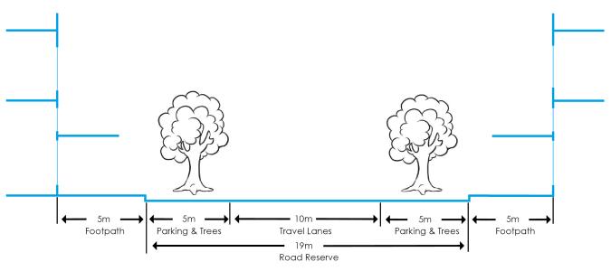
Concept 1
Road improvements (ie sub base reconstruction)
Upgrade of the existing footpath paving, lighting, street furniture and street trees
No. of car parking spaces 72, no change
Detail is provided by Figure H.
Concept 2
Concept 1, plus the following:
Widen the footpath on the northern side to create equal footpath widths on both sides of William Street and expand the opportunities for street activation
No. of car parking spaces 72, no change
Detail is provided by Figure I
Concept 3
Concept 1 and 2, plus the following:
36
Incorporate a central median (between Sturgeon and Port Stephens Streets) to improve pedestrian amenity and safety No. of car parking spaces: 67, loss of five spaces Detail is provided by Figure J
Adelaide Street
The role of Adelaide Street is to provide the principal vehicular access that caters to sub regional traffic. The layout and configuration of the road has not changed since it was bypassed by the M1 Pacific Motorway over 20 years ago.
A future concept design for the configuration of Adelaide Street is to take into consideration:
Retaining two through lanes per direction between Glenelg Street and William Street Retaining existing parallel kerb side car parking configuration where currently provided, except at approaches to and departures from Glenelg Street and William Street intersections
Reconfiguring Adelaide Street William Street intersection with kerb extensions and removal of exclusive left turn bays, to decrease pedestrian crossing distances
Introducing gateway markers to Raymond Terrace Town Centre. It is suggested to push out the tree treatment as far as possible to make the entry visible and slow down traffic
Introducing pedestrian crossing to slow down traffic with speed hump so that motorists are made aware of the pedestrian network in the
town centre. The gateways also serve as focal points that link up the pedestrian network
Converting the Adelaide Street Bourke Street intersection to a signalised intersection in support of the Sports Field development that will occur with the extension of Bourke Street.
Reviewing signal phasing for the signalised intersections along Adelaide Street in consideration of the intersection layout revisions
Port Stephens Street
Port Stephens Street functions as a secondary principal vehicular access to Adelaide Street. It serves as alternate access to the town centre from both the north and to the south.
A future concept design for Port Stephens Street is to take into consideration:
Retaining the existing cross section of Port Stephens Street between Glenelg Street and William Street
Providing speed tables as traffic calming measures on the Glenelg Street and William Street ends
Reconfiguring cross section of Port Stephens Street between William Street and Bourke Street to replicate the existing cross section between Glenelg Street and William Street
Converting existing central turning lanes between Bourke Street and Kangaroo Street into a planted median strip.
Considering converting rear to kerb angle parking between Bourke and Kangaroo Street to parallel parking
Actions
31. Consider further detail on the three options for the upgrade of William Street once funding i s identified.
32. Concept designs and costings will be developed for the upgrade of Adelaide and Port Stephens Streets and subsequently placed on public exhibition for comment.
33. Develop a parking management plan for Raymond Terrace defining the goals for parking provision and incorporate a Parking Structure Plan with a hierarchy of users, links to policies and controls.
37
Photo: William Street, Raymond Terrace
38
Figure H : William Street Upgrade Concept 1
Figure I : William Street Upgrade Concept 2
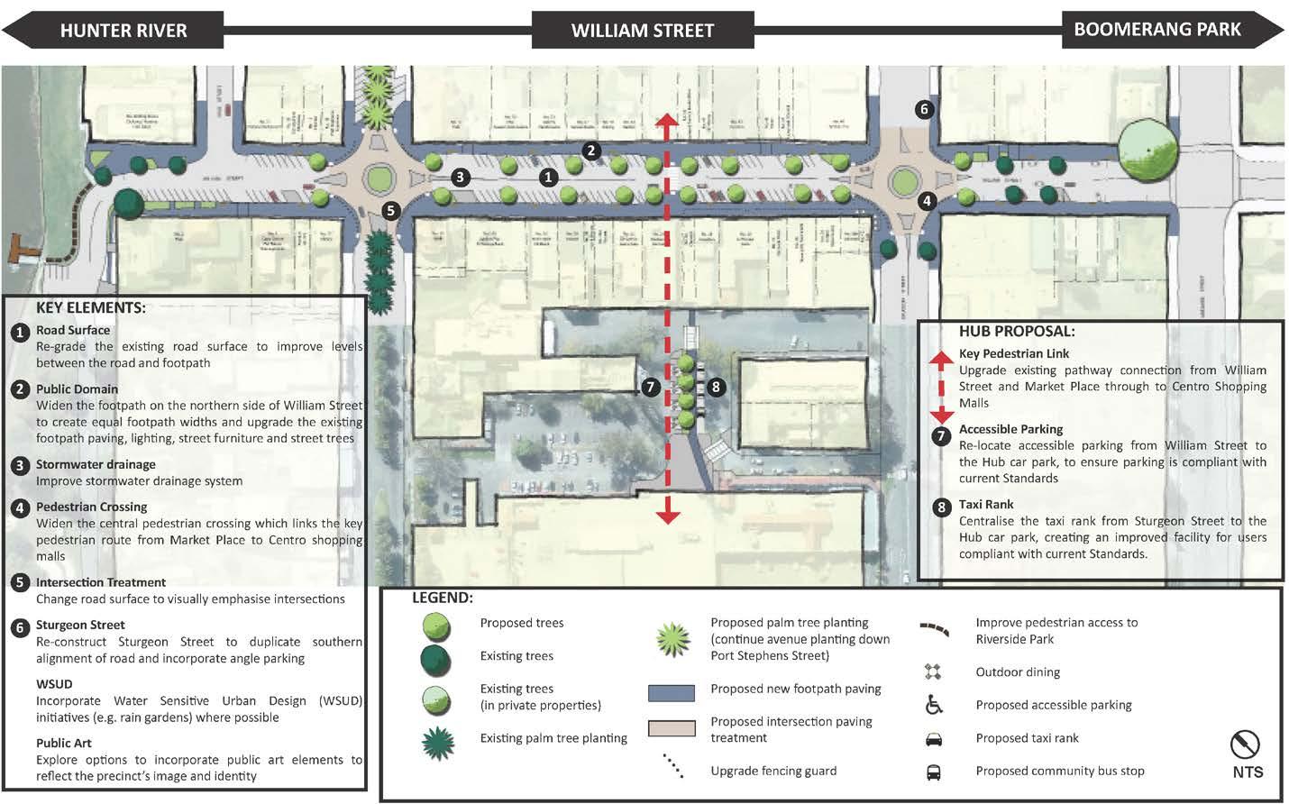
39
Figure J: William Street Upgrade Concept 3
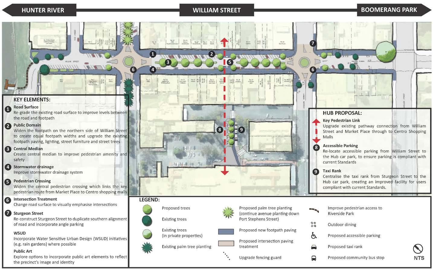
40
GOAL 4
- A resilient city with future development integrating heritage, consistency in the public domain and plan implementation
Photo: Roeth House, Swan Street, Raymond Terrace
GOAL 4
A resilient city with future development integrating heritage, consistency in the public domain and plan implementation
DIRECTION 4.1: Retaining connections to the past through integration of heritage into development
The earliest inhabitants of Port Stephens were the Aborigines of the Worimi Tribe. Port Stephens was first noted by Europeans in 1770 when Captain James Cook referred to Port Stephens in his log as 'an opening forming a bay'.
In 1801 Lieutenant Paterson took the survey vessel 'Lady Nelson' to investigate the coal outcrop that was discovered by Lieutenant Shortland at the mouth of the Hunter River. Paterson travelled upstream and came to the junction of the two rivers now known as the Hunter and Paterson River. Paterson camped overnight near this junction on the riverbank now known as Riverside Park.
This early European history represented in Raymond Terrace is due to its proximity to Sydney and its position on the banks of a river, which was considered the main means of transportation in 18th Century Australia.
The first plans drawn up for the township in 1835 generally correspond to the Town Centre of today. Within three years after the first allotments were offered for sale in 1837 and the town became an important centre with the stationing of police; a Court House, Pound, Church and Parsonage, a flour mill and stores, public houses, a doctor's surgery, shops and many private dwellings.
This rich history of Raymond Terrace is best illustrated by the riverside cottages and sandstone structures within the town centre. The buildings of identified significance are listed as heritage items and those that contribute to the heritage significance of the town centre are included within the heritage conservation area under the Port Stephens Local Environmental Plan 2013.
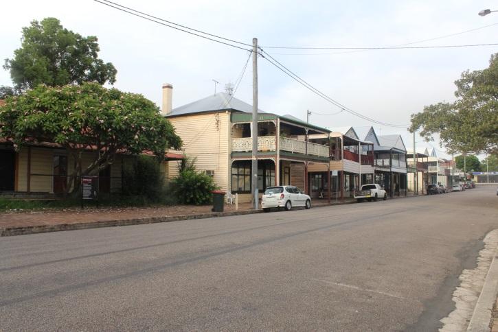
The role of the strategy should be to recognise this heritage significance so future development can capitalise on this setting with speciality shopping that is a point of difference from modern shopping environments. Opportunity exists for any new development to contribute to this setting rather than detract.
King Street
One of Raymond Terrace's key assets is its proximity and cultural ties to the river, some of which can still be interpreted via the heritage buildings on King Street. These aesthetic and historic attributes present a major opportunity for Raymond Terrace The King Street streetscape is aesthetically significant as a largely intact example of a 19th Century River Port Town consisting of single two storey timber buildings and single storey weatherboard residences.
King Street could potentially become a major indoor and outdoor dining location with high quality restaurants/ cafes as well as a unique destination for local produce and the arts. It is recognised that a number of constraints face the renewal of this precinct, such as:
• limited funding
• flooding
• the height of the river bank
• fragmented land ownership
• condition of existing buildings
However, the community and private investors are starting to recognise the opportunities that this location offers with recent developments evidencing the potential that King Street has to offer.
A set of guiding development principles have been formulated to guide the development of this precinct. These principles build on the existing Dickson Rothschild, 2007, 'King Street Waterfront Heritage Precinct, Raymond Terrace, NSW Urban Design Study' and have been incorporated into the amendments to D1 Heatherbrae and D9 Raymond Terrace Town
42
Photo: Historical King St, Raymond Terrace
Centre of the Port Stephens Development Control Plan 2014.
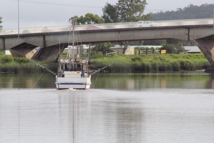
These guiding principles seek to ensure that new development retains the existing heritage character by retaining existing building elements, such as verandahs, and using materials and colours that are sensitive to the locality. The proposed development control plan amendments also seek to provide incentives for development by allowing a total overall reduction in the number of parking spaces that will be required.
It must also be noted that the future development of the King Street Precinct will also be enhanced through the commercial strategy/prospectus proposed under Action No. 14.
Actions
34. Part D9 Raymond Terrace Town Centre of the Port Stephens Development Control Plan provides additional guidance to heritage and incentives for the integration of historical significance into new development and the preferred location for gateway signage. The proposed Streetscape Design Guideline under Action No.36 will detail a common approach and standard to signage within the Raymond Terrace town centre.
Actions
35. Develop a streetscape design guideline to be used in the implementation of the William Street, Port Stephens Street and Adelaide Street upgrades. This guideline should seek to provide the same level of detail as the example provided within the City of Ipswich. 2013, 'Ipswich Streetscape Design Guideline A guide for Council, Developers and the Community'. This guideline will explicitly cover the following matters, which were raised during the exhibition period:
Consistent paving on the west/riverside footpath of King Street to match town/eastern side
Consistent themed historic signage
Specific and distinct furniture and lighting for the King Street Precinct
Style and character of public art that is in keeping and reflective of the locality
DIRECTION
4.2: Developing a streetscape urban design guideline for consistency in the town centre
The role of a streetscape urban design guideline is to go beyond the requirements of a development control plan in guiding a developer and Council as to the types of materials and elements that would be expected of an important public domain development. The role of this is to provide consistency of elements, such as street furniture, bins, street trees, paving, etc.
The production of this guideline comes at an opportune time as Council will be investing in the reconfiguration of William Street, which will provide an opportunity for the revision and updating of these urban design elements.
This guideline ensures that each piece meal and incremental development that occurs is consistent with an overall vision for the look and feel of a town centre. It demonstrates that detailed consideration has been provided to every element and that their 'look and feel' should stand the test of time through their durability and appearance.
DIRECTION 4.3: Establishing an implementation panel to provide continual input
The most important stage of this strategy is its implementation. The strategy has sought to clearly define a list of actions that are based on achieving over arching directions and goals.
The best way to ensure that the strategy is implemented is to form a panel that over looks the implementation of the strategy.
This implementation panel will consist of Councillors, Council Officers and community members. It will provide continued momentum to the actions of the strategy once it has been adopted by Council and be integral in providing feed back into future street
43
Photo: Boat on Hunter River, Raymond Terrace
upgrades and the facilitation of interim uses of sites, such as on the corner of Adelaide and William Streets.
Actions
36. Formulate an implementation panel that meets formally on a regular basis to drive the implementation of the actions contained within this strategy. The 'Terms of Reference' of this group will be formalised by Council when the strategy is reported to Council at the completion of the exhibition period.
37. Any future revision of this strategy is to acknowledge the drainage matters identified by numerous flood and drainage studies completed for Raymond Terrace/Heatherbrae and provide a critical path towards addressing these matters.
Actions
38. The implementation panel identified under Action No.37 is to engage and seek input from the sub region, such as representatives from Newcastle Airport, Medowie, Kings Hill, Karuah, Dungog, Tomaree Peninsula and Tomago.
DIRECTION 4.4: Reinforcing the role of Raymond Terrace as the prominent commercial centre to service the future needs of Kings Hill, Medowie, Tomaree Peninsula and other smaller towns
It has been continually reinforced throughout this strategy that Raymond Terrace and Heatherbrae are a major regional centre that provides services and support for those neighbouring towns.
This regional role relates to transport, being a pick up/drop off location for Sydney buses; government, being the location of the Port Stephens Council Administration Building; and open space, being the location of regional sporting fields that host events such as the Aboriginal League Knockout.
The purpose of this direction is to reinforce the need to underpin Raymond Terrace as this major regional centre in all future land use planning decisions.
44
Photo: Jacaranda Avenue, Raymond Terrace
IMPLEMENTATION
The key step in the development of a strategy is its implementation. This strategy identifies a number of clear and concise actions to ensure Raymond Terrace and Heatherbrae becomes a strong regional centre and a great place to live, work and play.
A concise summary of these actions, their assigned responsibilities and timeframes are provided under Figure I : Implementation Table (p. 46) and illustrated by the key action maps developed for Raymond Terrace (p. 50) and for Heatherbrae (p. 51).
The actions and their associated timeframes for the next 3 5 years have been made clear through the Implementation Table . However, it is those actions with 'ongoing' timeframes that will require continual monitoring, which is discussed in further detail under Monitoring and Review
NEXT STEPS
The strategy is up to the final step of implementation.
The implementation of this strategy will be the primarily responsibility of the Economic Development Unit of Port Stephens Council in consultation with the implementation panel.
The Economic Development Unit will seek assistance from other sections of Council, but it is the Economic Development Unit who will hold the key responsibility. Those goals, directions and actions are summarised in the following table.
MONITORING AND REVIEW
The following table illustrates those actions over an immediate time horizon of 3 5 years. This period commences when the strategy is formally adopted by Council following the exhibition period.
After three years, the strategy actions will be reviewed and the development of new actions may occur in order to achieve the defined goals and overall vision for Raymond Terrace and Heatherbrae. Within the table, the actions have been defined as either short, medium, long term or ongoing. The exact timing will be determined in consultation with the implementation panel. The short, medium, long and ongoing timeframes serve as an indicator to the resources and priorities from a Council perspective.
Where possible, these key actions have then been illustrated on the key action maps, which are provided as Figure L: Key Action Map Raymond Terrace (p.50) and Figure M: Key Action Map Heatherbrae (p.51).
45
Figure K: Implementation Table
Key:
ED Economic Development Unit
SP Strategic Planning Unit
IL Individual Landowners
RMS Roads & Maritime Services
FS Facilities and Services Group
PS Property Services Section
DAC Development Assessment & Compliance Section
CL Crown Land
GOAL 1 A competitive economy with regional services, including transport, health, justice, government, commercial, retail, industrial and entertainment
Direction 1.1 Growing a more regionally competitive centre by providing lands to strengthen the retail offering of Raymond Terrace and facilitating Heatherbrae as a destination for bulky goods
No Action
1 Monitor the supply of B3 Commercial Core and IN2 Light Industrial lands in Raymond Terrace as part of the review of the Port Stephens Planning Strategy that is set to occur in 2015/16. Then monitor the supply of these lands on an annual basis once the commercial strategy has been developed in accordance with Action No.14.
2 The Strategy identifies the following land for 4.5ha of B5 Business Development on the western side of the Pacific Highway to facilitate Heatherbrae as a 'key destination for bulky goods':
2253 Pacific Hwy (Pt Lot 62 DP 578367)
2259 Pacific Hwy (Pt Lot 1 DP 836879)
2249 Pacific Hwy (Lot 1 DP 161865)
Timing Owner
Medium ED SP
Short SP ED
2265 Pacific Hwy (Pt Lot 1 DP 1113232)
2273 Pacific Hwy (Pt Lot 2 DP 1113232).
3 Promote catalyst sites for commercial development to underpin William Street as the main street of activity catalyst sites are discussed under Action No. 24 (p.21).
Ongoing ED PS Direction 1.2 Enhancing transport and mode connectivity, including road, public transport, footpath and cycleway connections within Raymond Terrace and Heatherbrae
No Action Timing Owner
4 Identify ‘missing road links’ within the site specific Development Control Plan for Raymond Terrace and Heatherbrae
Short SP
5 Finalise the construction and maintenance of the multi transport hub at 'The Close' Short FS
6 Update and implement the Raymond Terrace Pedestrian & Cycle Strategy. Complete priority links and advocate for connections to the wider network, such as from Raymond Terrace to Newcastle and Maitland.
7 Support future proposals for increased public transport from Port Stephens.
8 Advocate for the southern interchange of the Heatherbrae Pacific Highway to provide northern access to Heatherbrae.
9 Undertake a detailed traffic analysis/management plan to determine the future traffic environment of Heatherbrae. This analysis will also identify opportunities for improved accessibility to support additional lands for bulky goods premises. Timing of this action is subject to the finalisation of the Heatherbrae Bypass Plan by RMS.
10 Address the informal access arrangements that have been created over 'community land' as defined under the Local Government Act 1993 for businesses with direct access to the Pacific Highway.
11 Consolidate the identified portions of roads within Riverside Park and the Raymond Terrace Trotting Track into the adjoining Crown Land Reserves
Medium FS
Ongoing ED SP FS
Ongoing ED SP
Medium ED SP FS
Long SD FS DAC RMS
Long FS CL
Direction 1.3 Planning for regional soft infrastructure services to meet the needs of a growing community
No Action Timing Owner
12 Advocate for Raymond Terrace amongst major institutions, such as the University of Newcastle, about the availability of affordable land and key catalyst sites both in Council and in private ownership. Catalyst sites and those with subdivision potential have been identified under Action No.24.
13 Recognise the role in providing services to those smaller surrounding centres, such as Medowie, Dungog, Kings Hill and Salt Ash through providing a more detailed audit of community services than what is provided under Action No.1 in the review of the Port Stephens Planning Strategy.
Ongoing ED PS
Medium SP
46
Direction 1.4 Raising the profile of Raymond Terrace through a commercial strategy/prospectus
No Action Timing Owner
14 Develop an economic/commercial strategy/prospectus that promotes land availability and its development potential, which will:
Assist landowners in understanding the development potential of their land under the planning framework
Provide prospective developers with an understanding of the precincts and business agglomerations present in Port Stephens
Provide current data (i.e. planned infrastructure investments, approved development types, etc.) through an online medium
Incorporate data regarding board market parameters from the Property Services Section of Council
Follow examples, such as the Wollongong City Council. May 2014, 'Wollongong Investor Prospectus' or 'Lake Macquarie Love the Lake'.
Short ED PS
GOAL 2 A city of housing choice with homes that meet our needs and lifestyles with a focus on providing for affordable accommodation, which includes seniors living and student accommodation
Direction 2.1 Enabling development that supports compatible land clustering 'like with like' land uses by the identification of key precincts, such as Kangaroo Street for Light Industrial, and Heatherbrae for bulky goods.
No Action Timing Owner
15 Investigate options to increase the maximum height of building from 9 to 15 metres at locations zoned R3 Medium Density Residential and from 12, 15 and 19 metres to 35 metres (10 storeys) at locations zoned B3 Commercial Core within the town centre to support opportunities for increased density.
16 Support the improvement of quality open space within Raymond Terrace and contribute to the target of 300 dwellings by implementing the Boomerang Park Masterplan.
17 Insert the standard instrument clause for activated street frontages into the Port Stephens Local Environmental Plan 2013 (NSW) and identify where development is to provide activated street frontages within the town centre to facilitate street activation.
18 The Department of Defence Administration Building is to provide a boardwalk/path along the Hunter River as part of their existing condition of consent. Council is to work with this property owner to finalise this portion of the boardwalk.
19 Identify a portion of land at the end of Speedy Lock Lane, Heatherbrae, known as Lot 173, DP 808771 from RU2 Rural Landscape to R2 Low Density Residential as a potential site for greenfield development to assist in achieving housing targets as identified for Raymond Terrace under the Lower Hunter Regional Strategy.
20 Monitor the subdivision of lots within the town centre as a part of the review of the Port Stephens Planning Strategy and facilitate discussions with developers for ways in which Council can assist in achieving density for those locations zoned R3 Medium Density Residential such as reduced parking requirements. An excellent forum to achieve this is provided by the Port Stephens Council Industry Reference Group (IRG).
21 Facilitate and encourage shop top housing within the town centre through ensuring the regulatory framework caters for this development type.
22 Review/Audit of future potential residential sites through the review of the Port Stephens Planning Strategy (PSPS).
Direction 2.2 Providing opportunities for affordable housing and seniors/retirement living
Short SP IL
Short SP
Short SP
Short DSC IL
Medium SP ED IL
Medium SP ED DSC
Short SP
Medium ED PS
No Action Timing Owner
23 Explore legislative and regulatory framework for further possible mechanisms to achieve small lot housing within the zone R3 Medium Density Residential under the Port Stephens Local Environmental Plan 2013 (NSW)
24 Similar to Action No.12, liai se with the University of Newcastle or private accommodation providers to promote Raymond Terrace as a location with affordable land, existing services and accessibility to the Lower Hunter Region.
Direction 2.3 Council facilitating the development of catalyst sites
Medium SP
Ongoing ED
No Action Timing Owner
25 Ensure the commercial strategy/prospectus under Action No.14 incorporates these sites and places a detailed emphasis on their most suited use and potential
GOAL 3 A great place to live with quality public and private spaces that are accessible
Direction 3.1 Improving the quality of existing public open spaces and undeveloped sites
Medium ED
47
No Action Timing Owner
26 Implementation of the Boomerang Park Masterplan subject to securing appropriate funding, which includes quality paths, play equipment, etc.
27 The Streetscape Design Guideline, which is proposed under Action No.36 is to take into account urban design elements, such as what trees and/or vegetation would be most appropriate for open spaces
28 Explore the possibilities for the activation of undeveloped sites, such as those sites identified as 'catalyst sites'. For example, the former Raymond Terrace sports field regularly hosts visiting circuses. While the site on the corner of Adelaide and William Streets could host pop up stalls to bring people into the town centre
Direction 3.2 Allocation and integrating locations for future passive open space
Medium FS
Medium SP FS DAC
Medium ED
No Action Timing Owner
29 Determine a preference for a location for passive open space, whether it be one of the three that have been identified:
51 William Street (Old Fire Station Building) and 53 William Street (Old RTA Building); 42 William Street (Port Stephens Communicate Building);and 16 & 18 King Street (Marriage Trees). or another suitable alternative. Any future development of these sites could be constructed in lieu of development contributions or Council may seek to construct it with the assistance of federal or state government grants
30 In accordance with Action 11.1.1.9 of the Port Stephens Community Strategic Plan 'Prepare a project plan to redefine the civic present of Raymond Terrace'.
Direction 3.3 Implementing main street upgrades
Long SP FS IL
Long SP ED
No Action Timing Owner
31 Consider further detail on the three options for the upgrade of William Street once funding is identified.
32 Concept designs and costings will be developed for the upgrade of Adelaide and Port Stephens Streets and subsequently placed on public exhibition for comment
33 Develop a parking management plan for Raymond Terrace defining the goals for parking provision and incorporate a Parking Structure Plan with a hierarchy of users, links to policies and controls. Considering a proposal to develop the former sports field site would result in a significant amount of car spaces
Short FS SP ED
Long FS
Long FS
GOAL 4 A resilient city with clear directions for improved social, environmental and economic outcomes
Direction 4.1 Retaining connections to the past through the integration of heritage into development
No Action Timing Owner
34 Part D9 Raymond Terrace Town Centre of the Port Stephens Development Control Plan provides additional guidance to heritage and incentives for the integration of historical significance into new development and the preferred location for gateway signage. The proposed Streetscape Design Guideline under Action No.36 will detail a common approach and standard to signage within the Raymond Terrace town centre
Short SP
Direction 4.2 Development a streetscape design guideline for consistency in the town centre
No Action Timing Owner
35 Develop a streetscape design guideline to be used in the implementation of the William Street, Port Stephens Street and Adelaide Street upgrades. This guideline should seek to provide the same level of detail as the example provided within the City of Ipswich. 2013, 'Ipswich Streetscape Design Guideline A guide for Council, Developers and the Community'. This guideline will explicitly cover the following matters, which were raised during the exhibition period:
Consistent paving on the west/riverside footpath to match town/eastern side;
Consistent themed historic signage;
Specific and distinct furniture and lighting for the King Street Precinct; and
Style and character of public art that is in keeping and reflective of the locality
Short SP FS
Direction 4.3: Establishing an implementation panel to provide continual input No Action Timing Owner
36 Formulate an implementation panel that meets formally on a regular basis to drive the implementation of the actions contained within this strategy. The 'Terms of Reference' of this group will be formalised by Council when the strategy is reported to Council at the completion of the exhibition period.
Short SP ED 37 Any future revision of this Strategy is to acknowledge the drainage matters identified Short SP
48
by numerous flood and drainage studies completed for Raymond Terrace/Heatherbrae and provide a critical path towards addressing these matters.
Direction 4.4 Reinforcing the role of Raymond Terrace within the Local Government Area commercial hierarchy as the prominent commercial centre to service the future needs of Kings Hill and Medowie No Action Timing Owner
38 The implementation panel identified under Action No.37 is to engage and seek input from the sub region, such as representatives from Newcastle Airport, Medowie, Kings Hill, Karuah, Dungog, Tomaree Peninsula and Tomago
49
ED
Short SP ED
Figure L: KEY ACTION MAP RAYMOND TERRACE
50
Figure M : KEY ACTION MAP HEATHERBRAE
51