IMPROVING URBAN RESILIENCE IN GHANA

The Intersection of Urban Transport & Informal Livelihoods
Princeton University
Woodrow Wilson School of Public and International Affairs
January 2019

The Intersection of Urban Transport & Informal Livelihoods
Princeton University
Woodrow Wilson School of Public and International Affairs
January 2019
This report would not have been possible without the valuable contributions of numerous people and institutions. The master’s students from the Woodrow Wilson School would like to acknowledge their support and thank them for their time and effort.
Invaluable input and guidance were provided by the team from the University of Pennsylvania School of Design including our policy workshop professor, Dr. Eugenie Birch, and two PhD candidates, Chandan Deuskar and Kimberly Noronha. Their expertise in the areas of urban design and planning augmented our research, enhanced our analysis, and informed our recommendations.
We would like to thank our client, 100 Resilient Cities, for allowing us to support its work in Accra and for providing resources and support throughout our time in Accra. We especially want to thank Jeb Brugmann from 100 Resilient Cities whose leadership, insight, and expertise helped shape the scope and direction of this project in impactful ways. We are also thankful for the guidance and coordination provided by Martine Sobey prior to our arrival as well as on site in Accra. Finally, we are grateful to the Rockefeller Foundation for hosting our team in its New York office and for offering us an opportunity to share the findings from our study.

The Woodrow Wilson School students would like to thank Karen McGuinness, Jeffrey Oakman and the other administrators in the Graduate Program Office at WWS who provided the logistical support that made our international travel possible. We also want to acknowledge the endowment from the Robertson family that financially supports the policy workshop experience for all master ’s students at the Woodrow Wilson School.
This project was enhanced by the input of many stakeholders working to bolster Accra’s resilience. These include representatives from the Accra Metropolitan Assembly, members of People’s Dialogue, officers from the Accra police force, local architects, and community members. Many conversations with these actors during our field research and the 100 Resilient Cities CoLab provided invaluable context and shaped our thinking about policy solutions.
Lastly, we express our gratitude for the people of Accra whose culture, history, and experiences we had the honor to study. In particular, we would like to extend our sincere thanks to the residents who welcomed members of our team into their homes and shared their daily routines for the purpose of our research. It was a privilege to see Accra through their eyes and to learn from their perspectives.
100RC 100 Resilient Cities – Pioneered by the Rockefeller Foundation
AMA Accra Metropolitan Assembly
BIGRS Bloomberg Initiative for Global Road Safety
BRT Bus Rapid Transit
PD People’s Dialogue on Human Settlements
PRA Preliminary Resilience Assessment
WWS Woodrow Wilson School of Public and International Affairs
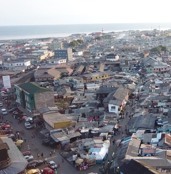
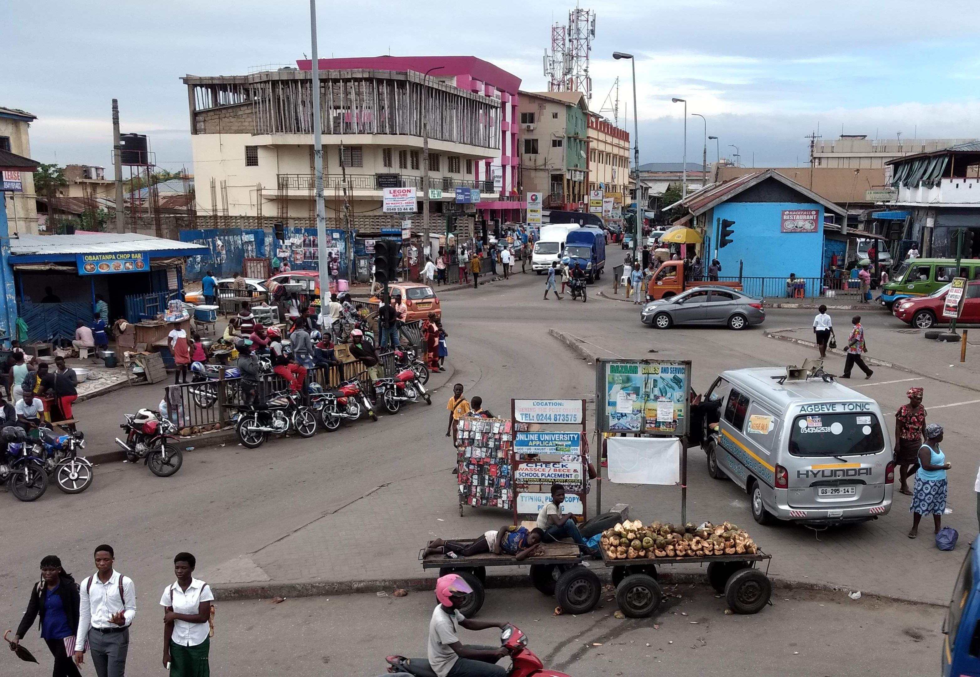
Accra has experienced rapid population growth over the past two decades, a phenomenon that has presented many challenges. Among the most important are the rise of informality, with the majority of Accra’s citizens employed in the informal economy or living in informal housing.¹ The city also faces a massive strain on its infrastructure; in particular, the transportation system is characterized by poor road conditions and safety hazards. Notably, transportation and informality converge on Accra’s streets, where vendors intercept vehicles at key intersections to sell a wide variety of goods—creating a dynamic ecosystem with its own set of complex concerns and opportunities.
Faced with these and other challenges related to its explosive urbanization, the Accra Metropolitan Authority (AMA) joined the Rockefeller Foundation’s 100 Resilient Cities (100RC) Initiative in 2014. Under this umbrella, it undertook extensive stakeholder participation exercises to identify critical physical, social, and economic stresses and develop remedies to address them. In so doing, the AMA articulated five goals to bolster the city’s resilience. Among them were two related to the transportation and informality issues discussed above:
1. Strengthen urban mobility and transportation; and
2. Recognize, embrace, and support the informal sector.
Seeking assistance in delineating policies to pursue these two goals, 100RC, represented by Jeb Brugmann, Vice President of Solutions Development & Innovation, commissioned a team of students at Princeton University’s Woodrow Wilson School of Public and International Affairs (WWS) to undertake a pilot study of vendor/vehicular behavior at two critical intersections: Wato Junction, located at the city’s historic center, and Cathedral Junction, a thoroughfare at the crux of some of the city’s important health and cultural institutions. The WWS study objective was three-fold: i) to research and analyze traffic and pedestrian flows as well as informal livelihoods activities at the two intersections, ii) to participate in and contribute to a 100RC multi-stakeholder workshop on generating improvement concepts for the two intersections with preliminary findings as inputs, and iii) to provide the final findings and recommendations on policies and institutional development measures that could facilitate the implementation of AMA resilience strategy to 100RC.
Under the direction of visiting professor Eugenie Birch and visiting lecturers Chandan Deuskar and Kimberly Noronha from the University of Pennsylvania, the WWS team conducted research at Princeton prior to carrying out a week-long field study in the two intersections and their surroundings. (See WWS, Topics on Informality in Ghana, 2019). During this field research, the team mapped traffic flows and documented vendor and driver behaviors, as well as analyzed the spatial features of each location. The team also participated in a 100RC-sponsored Co-Lab, a daylong stakeholder workshop, to gain a better understanding of the policy environment related to urban design, transportation, and planning in the city and to solicit ideas regarding the infrastructural and livelihood challenges identified at each site.
The WWS team discovered that Wato Junction, which serves as a thoroughfare and community destination, and Cathedral Junction, which acts primarily as a conduit for vehicles, experience little vehicle congestion, limited traffic backups, and high vehicular speeds even in peak traffic periods. However, the team did witness that both intersections exhibited significant pedestrian safety concerns stemming from poor design and maintenance. We concluded that both intersections serve vehicles rather than pedestrians or vendors, despite heavy vendor and pedestrian presence at each intersection.
The team also discovered that while vendors, as part of the city’s informal economy, provide key services at each intersection, they lead precarious lives. Vendors fulfill the public demand for such goods as water, snacks, sunglasses, and other small items; purchase products at local businesses; and collect waste or clean streets where they work. At the same time, they are physically and economically insecure. They earn highly variable incomes, engage in strenuous and dangerous work, and have little access to formal social safety nets. Further, their relationships with authorities are strained and fraught with tension.
In many ways, the intersections offer conditions that support a vendor ecosystem. To begin with, they provide a constant stream of customers who make purchases while paused for traffic lights. There is no space use or rental charge for vending, which is not the case at nearby formal markets. Adjacent businesses, which sometimes also hire the vendors to sell their goods, offer storage facilities and access to water and toilets.
Based on these findings, the WWS team generated recommendations to improve each intersection’s ability to serve vehicles, pedestrians, and vendors. Our ideas encompass the redesign of the individual intersections and policy solutions replicable city-wide. Regarding design, we suggest tactical interventions to improve pedestrian safety and walkability at Wato Junction and present solutions to integrate pedestrians/vendors and traffic flow more smoothly at Cathedral Junction. We also identified six city-wide policy proposals that include developing inclusive plans covering all forms of transportation and public space and creating means to legitimize vendor activities.
While we recognize that the original time period for the 100RC/AMA partnership is nearing a close, we hope that 100RC will find ways to support the AMA in achieving this report’s recommendations. The team also notes that its study is limited in terms of time, geography, and participants. Further research on resilience issues related to traffic, pedestrian safety, and informal livelihoods in Accra would round out the analysis presented here.
Chapter 1
"These conditions—high population growth, sprawling settlement patterns, and the dominance of informal economic activity—challenge Accra’s infrastructure and service provision capacity."
This report is the culmination of a semester-long Policy Workshop consisting of 12 Master in Public Affairs candidates at Princeton University’s Woodrow Wilson School of Public and International Affairs (WWS). Graduate policy workshops are a second-year practicum through which WWS students undertake a consulting project for public or social sector clients. Eugenie Birch, Professor of Urban Research at the University of Pennsylvania’s School of Design, oversaw the workshop, assisted by Chandan Deuskar and Kimberly Noronha, PhD students in City and Regional Planning at the University of Pennsylvania.
The client for this Policy Workshop was 100 Resilient Cities (100RC)— represented by Jeb Brugmann, Vice President of Solutions Development & Innovation. An initiative of the Rockefeller Foundation, 100RC is dedicated to helping cities around the world become more resilient to the physical, social, and economic challenges they face. Currently, 100RC supports 101 cities in the preparation and implementation of Resilience Strategies that help city governments to better manage chronic stresses and acute shocks so that city residents, especially the poor and vulnerable, are safer, healthier, and have enhanced livelihood options. In addition to engaging directly with cities, 100RC also works to catalyze and contribute to a larger global urban resilience movement.
In Spring 2018, 100RC requested the assistance of the WWS Policy Workshop team to support its work with the Accra Metropolitan Assembly (AMA) in Ghana’s capital city, Accra. A member of the 100RC Network since December 2014, Accra has been working collaboratively with 100RC to develop its roadmap to resilience. As part of the first phase of the
process, 100RC and AMA officials completed a Preliminary Resilience Assessment (PRA) in 2016, developed through field research, broad stakeholder consultation, and an evaluation of existing programs, initiatives, and plans.²
Through this preliminary assessment, the AMA identified five “Discovery Areas,” or key resilience building opportunities: i) strengthening urban mobility and transportation, ii) improving management of flooding, waste, and sanitation, iii) citizen engagement towards greater accountability, iv) recognizing, embracing, and supporting the informal sector, and v) creating an environmentally sustainable city. This report aims to assist 100RC in the development of the following two Discovery Areas:
1. Strengthening urban mobility and transportation: An Accra with affordable, inclusive, safe, and sustainable transportation options that support citizens to thrive in the wake of everyday stresses and shortfalls accompanying disasters and emergencies.
2. Recognizing, embracing, and supporting the informal sector: A more resilient, equitable, and inclusive city that better understands and incorporates the realities of informality in order to promote inclusive development, increased tourism, creative economies, and sustainable economic growth for the benefit of all.
In particular, 100RC asked the WWS Policy Workshop team to:
1. Research, document, map, and analyze the two intersections through the collection of data on traffic and pedestrian flows, commercial and informal livelihood activities, and other land uses to inform governmental and nongovernmental stakeholder efforts to improve conditions in these intersections, consistent with the Accra Resilience Strategy.
2. Develop preliminary findings and recommendations from the above research as inputs for consideration for Accra’s Resilience Strategy development process, including the generation of improvement concepts for the two intersections, as well as policies that could facilitate city-wide implementation of the identified resilience objectives. The report is composed of six sections. Chapter 1 describes the context of the project and outlines the research methods and data sources employed by the WWS research team; Chapter 2 presents the findings related to the spatial attributes of each intersection; Chapter 3 presents the findings on informal economic activity at each site; Chapter 4 provides a consolidated analysis of the research findings; Chapter 5 describes the results of Co-Lab workshop sessions; Chapter 6 offers policy recommendations and concludes with suggested next steps and considerations for future work.
As identified by the PRA, Accra faces several challenges that threaten the city’s resilience. Rapid urbanization and population growth have put enormous stress on Accra’s public infrastructure systems and resources. In 1950, the population in Accra was just 177,000. Today, the Accra Metropolitan Area, Accra’s most populous and central municipality, has an estimated 1.6 million residents.³
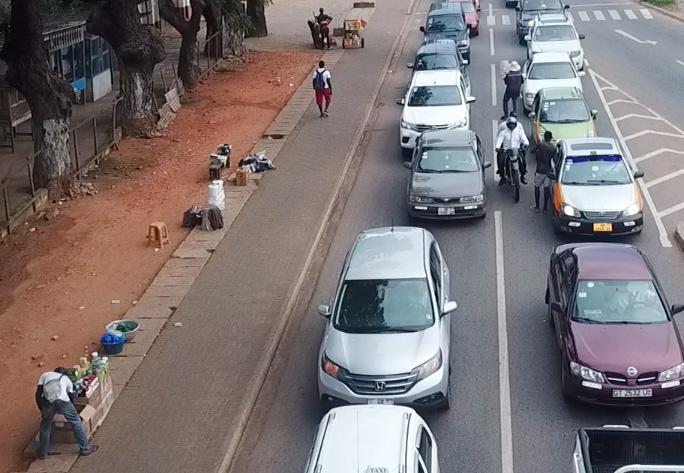
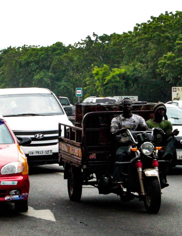
Accra’s unprecedented population growth has also accelerated the city’s spatial expansion. This larger footprint, alongside increased housing prices, has led to a significant decline in population density throughout Accra, with many poorer residents flocking from central Accra to the city’s outskirts. Currently, roughly 2 million people commute into and out of Accra each day.⁴ Coupled with a relative dearth of public transportation, the area's pattern of growth has contributed to traffic congestion and an increase in the number of traffic-related accidents. Pedestrian fatalities and injuries are commonplace throughout the city.⁵
High levels of informality also characterize Accra's growth. More than half (58 percent) of the city’s population lives in some form of informal settlement, while three quarters are employed in the informal sector.⁶ Here workers take on a variety of roles, as waste collectors, home-based producers, and street vendors. Informal street vending plays an essential role in the city’s economy, providing cheap and accessible goods and services to residents and attainable employment opportunities to lowincome city dwellers. However, informal workers in Accra face many challenges, including unstable incomes, a lack of social safety net, unclear regulatory environments, exploitative treatment from local officials, and numerous occupational health and safety hazards.
These conditions—high population growth, sprawling settlement patterns, and the dominance of informal economic activity— challenge Accra’s infrastructure and service provision capacity. Road corridors are often congested during weekday rush hours as workers traveling in cars, motorcycles, and tro-tros (privately owned minibus taxis) commute to and from work. Congestion at key intersections attracts high numbers of street vendors who dodge traffic to sell a wide range of goods. While these public spaces facilitate the passage of traffic, they are also home to an ecosystem of pedestrians, motorists, and informal vendors who engage in a variety of economic and social activities. Poorly planned to accommodate these two functions, Accra’s intersections have become a source of crowding, danger, and pollution, testing the city’s ability to properly manage this part of its urbanization.
In order to tackle these challenges, 100RC has been working with the Bloomberg Initiative for Global Road Safety (BIGRS), a Bloomberg Philanthropies’ program that is providing the AMA with technical assistance to improve pedestrian safety. BIGRS selected the two intersections as the focus areas for the WWS team’s research—Wato Junction and Cathedral Junction. The sites are characterized by multiple modes of transportation, mixed land use, and roadside hazards. Both are home to permanent, semi-permanent, and mobile vendors who occupy the intersections to sell their goods, often without the formal acknowledgement of city officials.
While no one intersection is fully representative of Accra’s landscape, these sites represent two types present in the city each having different traffic flows, pedestrian patterns, and informal livelihood practices. Together, they offer an
opportunity to map, through field observation and interviews, the spatial and economic dynamics at play on Accra’s streets and public spaces. They also present an entry point for understanding the elements of city-wide street design, policy, and institutional development that are required to implement the AMA’s Resilience Strategy.
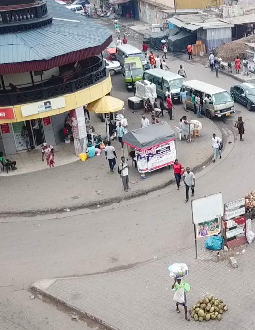
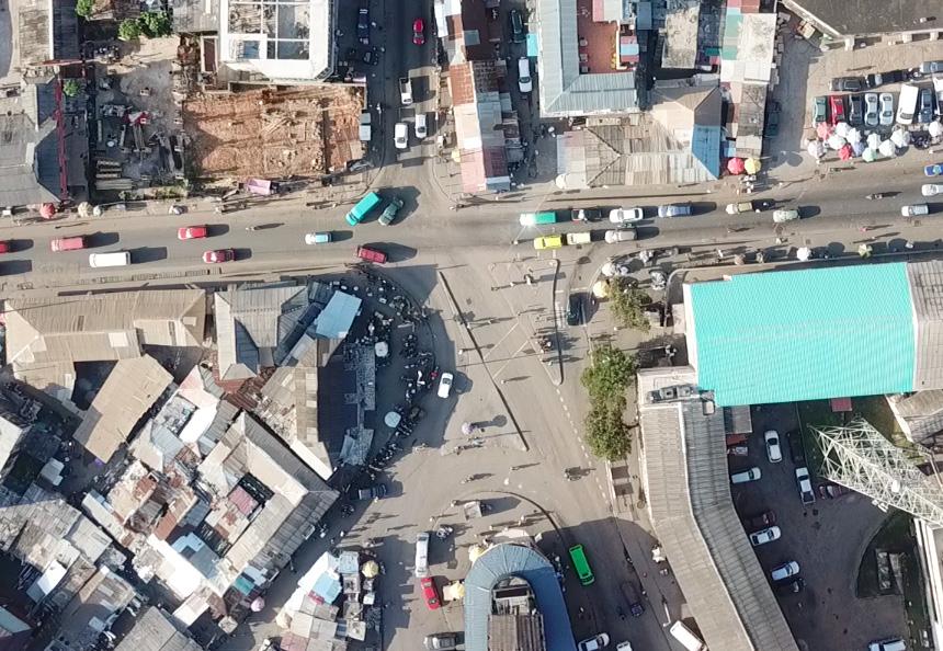
Wato Junction, the historic center of old Accra, serves social and economic functions while acting as a major conduit of traffic moving to and from the modern central business district. Five streets converge at the intersection. Pedestrian exposure to vehicular traffic is high due to the existence of nearby schools, markets and a densely populated residential neighborhood. Children, the elderly, and persons with disabilities face a heightened risk of accidents.
A major traffic thoroughfare, Cathedral Junction connects the adjacent and outlying residential areas with surrounding health facilities and business districts. Challenges facing the intersection include the high incidence of jaywalking, dysfunctional traffic lights, and illegal motorcycle activity. As with Wato Junction, people with disabilities and other vulnerabilities are at particular risk at this site.
Rapid urbanization and population growth have put enormous stress on Accra’s public infrastructure systems and resources.
In addition to the research conducted at Princeton, the findings in this report draw on primary datacollection in Accra. (See WWS, Topics on Informality in Ghana, 2019). In a field study in October 2018, a combined WWS-AMA team observed the spatial characteristics, vehicle and pedestrian patterns, and vendor attitudes and behaviors at Wato and Cathedral Junctions. 100RC and the WWS team presented the findings to a group of local stakeholders and elicited their views on high-priority issues via a 100RC-sponsored Co-Lab workshop. Due to time constraints, fieldwork data were only collected over a five-day period, so findings should be interpreted as indicative, rather than fully representative, of conditions at the two intersections. This work offers a model for additional in-depth studies.
The WWS team collected data on land use, pedestrian and vendor volumes, and traffic flow patterns at each intersection. Specifically, the team undertook the following studies:
Land Use. Within a two-minute walking radius of the intersections, the team mapped current land use (as compared to formal zoning land use). The team also documented vehicular types and behaviors: private automobiles, motorcycles, and tro-tros (privately owned minibuses that function as shared taxis, operating on fixed routes) and their parking and temporary stopping points practices.
Appraisal of Motor and Pedestrian Infrastructure. Within the two-minute, walking radius of each intersection, the team conducted a visual appraisal of motor and pedestrian infrastructure, focusing on quality, maintenance, access, safety, and aesthetics.
Pedestrian Volume and Flow Patterns. For three time periods throughout the day (8AM, noon and 5PM), the team collected data on the volume of pedestrians crossing each node of the intersections. They disaggregated the pedestrian volume count by pedestrian type, focusing particularly on vulnerable populations including children, disabled or elderly persons, and load-bearing pedestrians. The team also mapped the major patterns of pedestrian flows at each intersection for each period.
Vendor Volume, Location, and Flow Patterns. For three periods throughout the day, the team collected data on the volume
and movement of vendors. They disaggregated the vendor volume by type of vendor (mobile and stationary) and by category of goods sold (food, beauty/health/ apparel, electronic, housewares, or general/other). The team also mapped vendor locations and movement disaggregated by vendor type at each intersection.
Social Gathering. The team mapped the spaces used for social gathering at each intersection for three periods.
The WWS-AMA team monitored traffic and pedestrian flow at each intersection for the three time periods over two days, gathering data on:
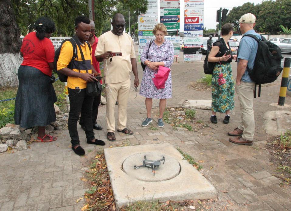
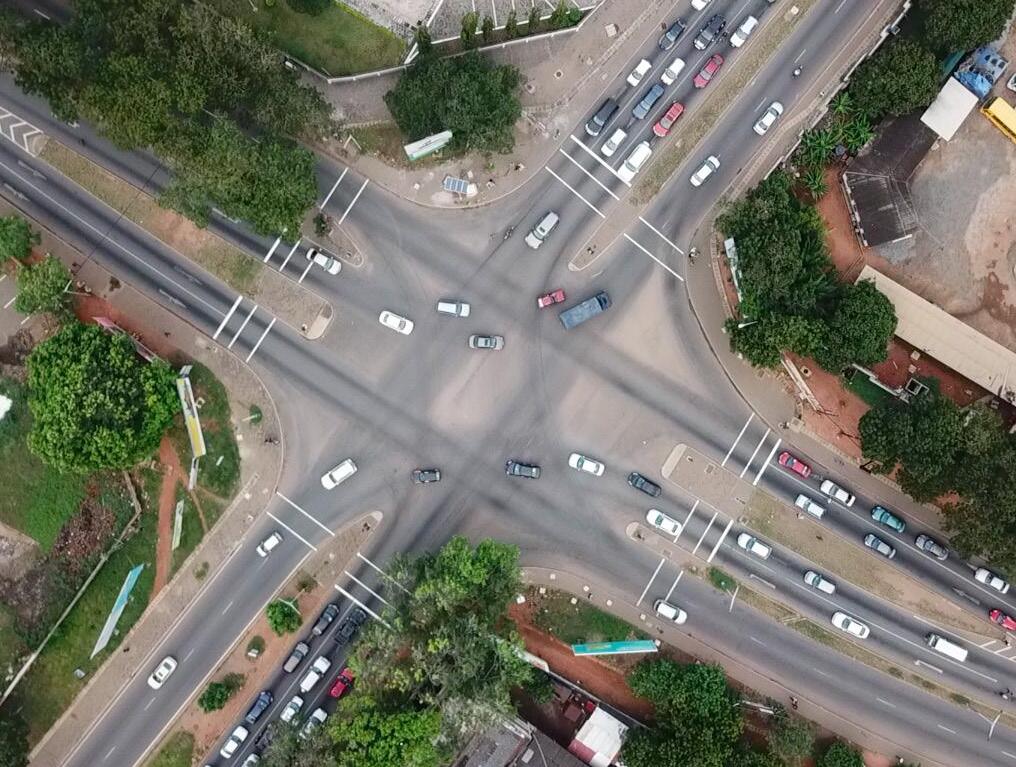
Vehicle Turning Counts. Using drone footage, the team counted the number of vehicles passing through the intersection, disaggregated by the direction of traffic. The total was then divided by the duration of the footage to obtain an estimate of flows per unit time.
Pedestrian Flow Counts. Using drone footage, the team counted the number of pedestrians crossing at or near the intersections, disaggregated by lanes crossed. The total was then divided by the duration of the footage to obtain an estimate of flows per unit time.
Origin and Destination Surveys. The AMA officials approached the vehicles stopped at traffic lights to survey drivers on the origins and destinations of their trips. Five data points were gathered for each lane in each time period.
The research team prepares the drone, acquired through partnership with local stakeholders, to capture traffic and spatial footage. Students interview local street vendors to gain a deeper understanding of the vendors' work routine.Backup Length. The maximum length of traffic backup was measured for each lane feeding into the intersection to gauge the level of service of roadways near intersections.
Obstacle Assessment. The WWS team and AMA staff recorded behavioral or infrastructural bottlenecks that could potentially cause congestion or crashes.
The WWS team collected data on the behaviors, well-being, and needs of vendors working at Wato and Cathedral Junctions. The team used three methods to gather this information:
Direct Observation. The team observed vendors at their places of work, extracting insights about their routines and interactions at each junction.
In-Depth Interviews. The WWS team, assisted by translators from People’s Dialogue on Human Settlements (PD), a Ghanaian community-based, non-governmental advocacy organization for informal workers, conducted semi-structured interviews with vendors about their day-to-day experiences.
Rapid Photo-Ethnography. 100RC worked with PD to arrange home visits with one vendor from each intersection. Host families were asked to take 40 photos representing their lives and were later interviewed about the meaning of the most relevant pictures. The photos allowed the team to explore vendors’ day-to-day lives from different perspectives.
100RC Co-Labs are a convening of 100RC staff, city officials, and subject matter advisors designed to drive innovation in services, tools, and products in response to complex city resilience challenges. They offer a collaborative opportunity for stakeholders to identify relevant resilience issues in a given city and generate ideas to solve these issues.
On November 1-2, 2018, members of 100RC, the AMA, and other groups convened for a Co-Lab on urban transportation and livelihood resilience challenges in Accra. Represented stakeholders included, but were not limited to: AMA Department of Transportation, the National Development Planning Commission (NDPC), People’s Dialogue (PD), the Bloomberg Initiative for Global Road Safety (BIGRS), Institute for Transportation and Development Policy (ITDP), the Accra Police Force, members of the WWS team, and other independent researchers.
The Co-Lab process was as follows:
1. 100RC introduced a framework for considering resilience challenges in Accra.
2. The WWS team presented the results and analysis of their fieldwork.
3. Participants broke out into groups for collaborative discussions. During discussions, each table of participants was tasked to prioritize key resilience gaps in Accra, brainstorm and shortlist a set of potential solutions, and ultimately select one idea to refine for presentation. Each table then presented a resilience-building initiative for consideration by the wider group.
The ideas generated by the Co-Lab are detailed in Chapter 5. These stakeholder-generated insights and initiatives were used as inputs for this report.
At each intersection, the team reviewed the history, current context, and land use, and collected primary data for site analysis focusing on transportation and infrastructural challenges.
Junction was once the center of Old Accra. The area was first inhabited by the fishing communities of the Ga people, who still inhabit the space today.⁷ Beginning in the late 1600s, British and Dutch colonists entered the region around Wato Junction, creating the James Town neighborhood to the south and Ussher Town to the north.⁸ Today, Ussher Town has been developed and modernized and is now host to Makola Market, Accra’s largest trading hub. James Town, however, has retained much of its original form and functions as a commercial fishing village. The surrounding blocks north
of Wato Junction primarily have commercial uses at street level, and office or residential uses above. To the south, the surrounding blocks are primarily informal mixed-use, with the exception of the Ghana General Post Office. Formed by the intersection of Kwame Nkrumah Avenue, Asafoatse Nettey Road, and Lutterodt Street, Wato Junction serves as both a gateway to the nearby neighborhoods and a hub connecting commuters to the rest of city. Wato Junction is a place of communal and historic importance in Accra. Located between two of the city’s trading forts, Wato
Wato Junction is a place of communal and historic importance in Accra.
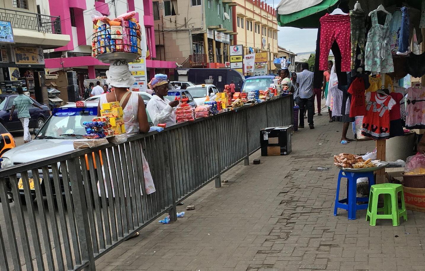
Wato Junction has an irregular street network and block structure, inherited from its pre-colonial settlements. The mixed land use in and around Wato Junction reflects its functional diversity and dynamism. East of the intersection, on Asafoatse Nettey Road, are commercial office buildings and the Ghana General Post Office. Vending stalls—both permanent and semi-permanent—offer a lively atmosphere along the streets.
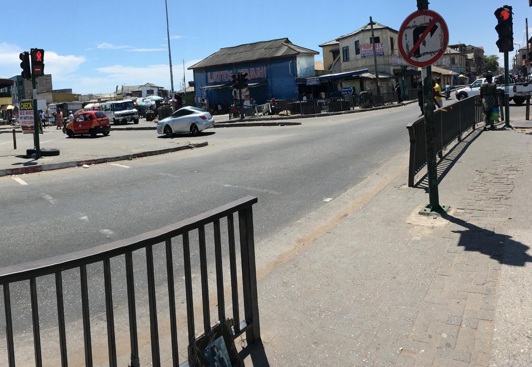
Streets and sidewalks display a mix of functional infrastructure with low levels of standardization and maintenance. Near the intersection, streets are well-paved and have designated lanes; pedestrian and traffic lights are functional. Automobiles generally observe traffic signals, although motorcycles routinely ignore signage and drive against the intended direction of traffic. Tro-tros frequently run the red light on Kwame Nkrumah Avenue to turn west onto Asafoatse Nettey Road.
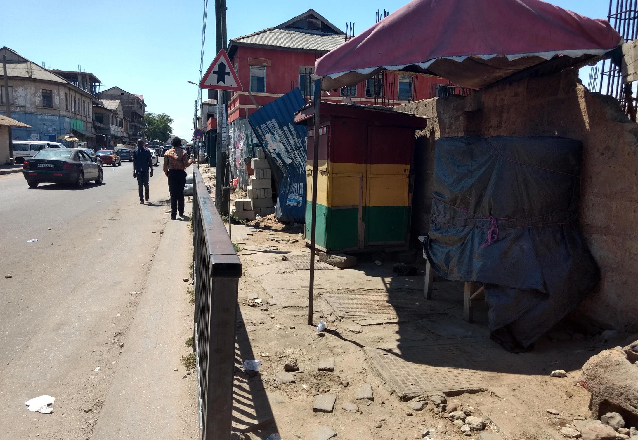
Many sections of sidewalk leading to the intersection are fairly wide (about six feet), well-paved, and free of trash. However, the sidewalk infrastructure displays a lack of appropriate design thinking, standardization, and maintenance. Whereas streets in the immediate vicinity of the intersection have sidewalks, sidewalks disappear on road sections further away from the intersection. On Nii Owoo Road and Atukpai Road at the south of the intersection, sidewalks are either severely obstructed by the expansion of living quarters, or they narrow and end abruptly. The lack of careful attention to design is also evident in that sidewalk widths vary significantly throughout the intersection.
In general, even where sidewalks are well-paved, there are physical obstacles to pedestrian access. Construction debris and abandoned utility poles limit sidewalk space and maneuverability, especially for people with disabilities. Pedestrian access at the corner of Kwame Nkrumah Avenue and Asafoatse Nettey Road is particularly limited, with vehicles parked directly on sidewalks and construction spillover impeding access. At the corner of Nii Owoo Road and Asafoatse Nettey Road, meanwhile, parked motorcycles, a large but severely slanted sidewalk, and heavy vendor presence restrict pedestrian usage.
At the intersection’s southern corner, the open space located in front of and under the arcade of the former Wato Club restaurant is advantageous to vending. The arcade offers vendors protection from the sun and rain, while the space in front of the arcade has high visibility. Furthermore, the streets on either side of this corner are used as informal tro-tro and taxi stops, providing a steady stream of potential customers. One moderate disadvantage of the space under the arcade is its sunken elevation; the space is vulnerable to flood during periods of heavy rain.
Finally, sidewalks lack features for accessibility and nighttime pedestrian access. Sidewalks do not have pedestrian ramps for wheelchairs. At night, the intersection is poorly lit, significantly reducing visibility for both pedestrians and automobiles and increasing the chance of accidents. Public open space is generally located on the south, east, and west sides of Wato Junction. However, public space is insufficient to accommodate the volume of pedestrian traffic traveling through Wato Junction on a daily basis, and what exists is highly underutilized due to a multitude of surface obstructions.
On the east side of the intersection, the wide sidewalk is used for vending and congregating. Three mature trees offer protection from the sun and rain, while the steps and veranda of the Ghana General Post Office building provide seating and a platform to view the intersection. Pedestrians use this corner to congregate and read newspapers. Of all the open spaces surrounding the intersection, this corner is the most comfortable for sitting and standing throughout the day.
The southwest corner of Wato Junction is used for vending, congregating, and transport. Several mobile food vendors and a semi-permanent restaurant sell there, and motorcycle taxis have established an informal transport hub. This is the only corner where people have stationed makeshift benches for sitting. However, a major disadvantage of the space is the steep incline that slopes towards a site drain, precluding all access to that portion of the space.
The roadway system at Wato Junction comprises five road branches, each carrying one-way vehicular traffic. The main northsouth street, Kwame Nkrumah Avenue, carries the southbound traffic from the Ring Road to Asafoatse Nettey Road, terminating at Wato Junction. A second northsouth, one-way street, Lutterodt Street, begins at Wato Junction, carrying the southbound traffic towards John Evans Atta Mills High Street along the coast. The main east-west street, Asafoatse Nettey Road, is a one-way, arterial road that carries outbound traffic from the city center towards the James Town neighborhood. The two local streets, Nii Owoo and Atukpai Roads, branch off from Wato Junction towards James Town and primarily carry pedestrian traffic.
Formal public transit lines travel along Asafoatse Nettey Road, making stops at the northwest corner of Wato Junction. Tro-tros and taxis stop at the southeast corner of the intersection along Lutterodt Street. The guardrails located along the sidewalk corners of Wato Junction together with pedestrian medians channel pedestrian circulation. No bicycle infrastructure exists.
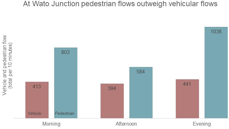
The vehicular and pedestrian flows at Wato Junction peak during the morning and evening rush hours. The WWS team counted vehicle flows by type of vehicle and direction in several 10-minute intervals. Aggregating by all vehicle types and directions, an average of 41.3 vehicles per minute travel through the intersection in the morning rush period; 44.1 vehicles per minute pass during the evening rush period. In the afternoon period, the average number of vehicles drops to 39.4 per minute. Pedestrian flows outweigh vehicular flows. The number of pedestrians is roughly double the number of vehicles in the morning, two and a half times the number of vehicles in the evening, and one and a half times the number of vehicles in the afternoon. (Figure 1)
Morning Peak Period. Around 50 percent of all vehicular traffic in Wato Junction runs from east to west along the one-way Asafoatse Nettey Road, with about 218 vehicles passing in this direction every 10 minutes during the morning rush hour. The second highest vehicular traffic flow occurs as vehicles drive south from Kwame Nkrumah Avenue and turn right onto Asafoatse Nettey Road: about 58 vehicles every 10 minutes. Vehicular flow is moderate or low—even negligible—to and from adjacent roads, including Lutterodt Street, Atukpai Road, and Nii Owoo Road. (Figure 5)
As for pedestrians, a sizable stream of people heads from the
southwest part of Wato Junction to the north and northeast, in the general direction of Makola Market, during the morning rush. Most pedestrians make several crossings, primarily through the two traffic islands located at the center of the Junction, onto the northern side of Asafoatse Nettey Road. (Figure 4)
Afternoon Period. The off-peak, afternoon period sees moderately reduced vehicle and pedestrian flows. On average, 394 vehicles and 584 pedestrians cross through the intersection every ten minutes (Figure 1). School children make up a larger share of pedestrians in the intersection at this time.
Evening Peak Period. The evening rush hour sees an increase in vehicular and pedestrian flows relative to the morning. For the most part, vehicles travel along Asafoatse Nettey Road. At 241 vehicles for every 10 minutes, the east-west flows account for more than 50 percent of all vehicles. The traffic from Kwame Nkrumah Avenue to Asafoatse Nettey Road also sees a slight increase relative to the morning traffic, but proportionally, the number (73 vehicles every 10 minutes) remains moderate. In adjacent streets, vehicular traffic is moderate to almost nonexistent. (Figure 8)
While the total number of pedestrians in the Junction increases from 803 to 1,038 per ten-minute period between the morning and evening rush hour, the direction of pedestrian flows reverses across Asafoatse Nettey Road and towards the southwest area. Pedestrians walk from the Makola Market, presumably back to the James Town neighborhood, during the evening. (Figure 7)
Automobile parking at Wato Junction is predominantly informal, with the nearest dedicated parking spots approximately 50 meters
east along Asafoatse Nettey Road. Automobiles park along both sides of Lutterodt Street. At Kwame Nkrumah Avenue, they park either along the curb or on the sidewalks. During the evening rush hour, motorized vendors park on pedestrian medians to sell their merchandise. Throughout the day, motorcycles park along the curb and on the western edge of Wato Junction. (Figures 6 & 9)
The team collected data on pedestrian type and pedestrian crossing behaviors in addition to pedestrian flow data.
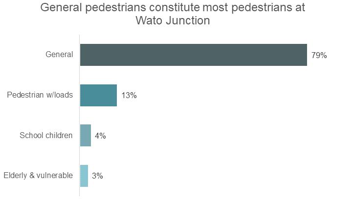
Pedestrians fall into four categories—general, elderly and vulnerable, school children, and pedestrians with loads. General pedestrians constitute most pedestrians at around 79 percent, while each of the other categories constitute 3-13 percent (Figure 2). Elderly and vulnerable pedestrians include people with limited mobility including mothers with toddlers and persons with disabilities.
Children who live around the Wato Junction commute daily to several local schools, including Holy Trinity Cathedral Senior High School, Bishop Girls School, St. Mary’s Anglican Pre-school, Seventh Day Adventist School, Accra Sampe School, and Richard Akwei Memorial Basic School. The AMA has identified “mak[ing] the journey to school safe” as one of the seven pillars of its pedestrian safety plan.⁹ However, young children who attend neighborhood schools cross haphazardly through the streets at Wato Junction.
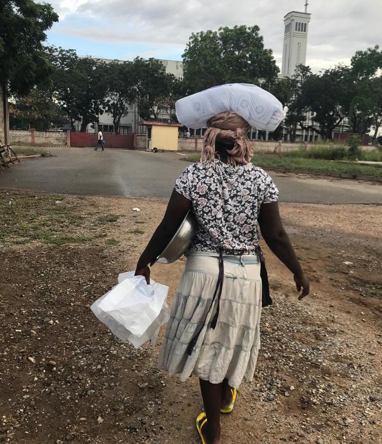
Finally, many pedestrians cross through the intersection bearing heavy loads, often on their heads. These people are less able to move out of the way of oncoming traffic, and avoid pedestrian traffic islands so they do not have to step up onto the curb. Rather, they walk through the carriageway, making them more vulnerable to oncoming vehicle traffic. Many people carrying loads through the intersection are vendors traveling from James Town to Makola Market or other parts of the city.
As a popular neighborhood gathering center, Wato Junction is home to different kinds of vendors that serve the surrounding community. As per the WWS team’s data collection, there are a wide variety of goods sold in Wato, with vendors selling food comprising around 65 percent of the total market. Vendors specializing in electronic goods such as cell phones or headphones take up nearly 14 percent, with beauty/ apparel and general merchandise claiming about 9 percent each.
The highest density of mobile vending occurs in the morning, when mobile vendors, usually selling food, travel from James Town in the south and move northward, presumably to sell at Makola Market. The number of vendors gradually decreases throughout the day, and the flow of movement reverses as people make their way back towards residential James Town in the afternoon and evenings. (Figure 3)
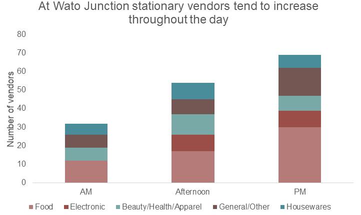
Stationary vendors tend to increase throughout the day with the number of vendors more than doubling by the evening. Food is the most common item sold—vendors selling it comprise between 31 and 43 percent of the market share depending on the time of day. Vendors tend to sell in more spacious areas where pedestrians can easily access their stalls as they pass through.
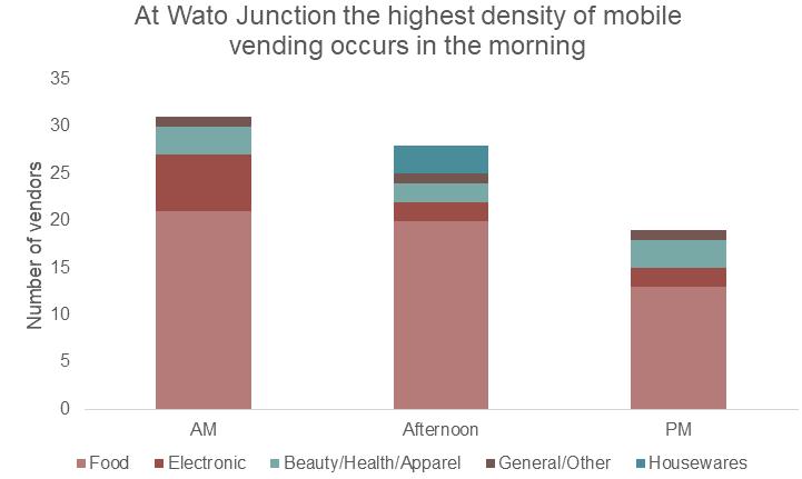 Figure 1. Source: Primary data collection (manual counts and drone footage)
Figure 2. Source: Primary data collection (manual counts)
Figure 3. Source: Primary data collection (manual counts)
Figure 1. Source: Primary data collection (manual counts and drone footage)
Figure 2. Source: Primary data collection (manual counts)
Figure 3. Source: Primary data collection (manual counts)
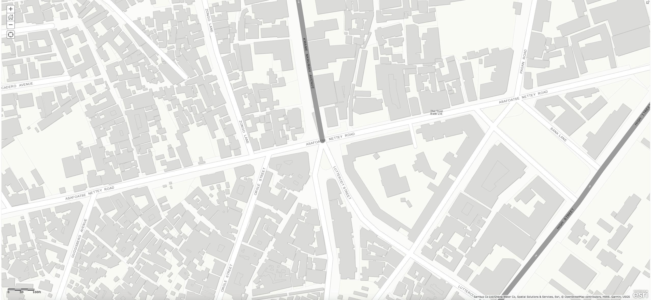 Figure 4. Morning Peak Period: Pedestrian Circulation
Figure 5. Morning Peak Period: Vehicular Circulation
Figure 4. Morning Peak Period: Pedestrian Circulation
Figure 5. Morning Peak Period: Vehicular Circulation
As a gateway to the James Town neighborhood, Wato Junction has high volumes of pedestrian traffic relative to vehicle traffic. However, roadways take up much of the space, with five branches of roads coming together in the junction. Multiple points of exposure to vehicular traffic represent a risk to pedestrian safety.
During the morning and evening rush hours, corners and traffic islands become very crowded as people wait to cross. Pedestrian spillover onto roads increases their exposure to traffic and associated risks. The light cycle at Asafoatse Nettey Road only
allows pedestrians 17 seconds to cross—an insufficient window to accommodate the hundreds of people crossing at peak times.
Many pedestrians typically choose to take the shortest possible route between James Town and the two eastern corners of the intersection. They walk through the roadway at Salaga Market and Lutterodt Streets, avoiding the two pedestrian islands at the center. Walking through the street (outside of the crosswalk) obviously increases the risk of being struck by a vehicle.
Obstructed sidewalks also compound the issue of insufficient pedestrian space at the intersection. The construction on the northwest corner forces pedestrians into the street as they navigate around piles of debris. The sidewalk of
the northeast corner narrows significantly towards the north, and vendor stalls take up scarce sidewalk space. The southwest corner has several vendor stalls and a steeply slanted sidewalk, making the corner difficult to traverse. Moto taxi parking along the perimeter effectively blocks the corner to pedestrians. These contribute to the preference for crossing through the two islands and onto the northeast corner rather than on the western side of the intersection. This results in pedestrians traversing three lanes of traffic rather than just one, increasing exposure to oncoming vehicles. The advantage of this system, however, is that pedestrians crossing in this manner do not obstruct the relatively high-volume turn lane from Kwame Nkrumah Avenue to Asafoatse Nettey Road.
Pedestrian guardrails along the northeast, southeast, and southwest corners create additional bottlenecks. During the evening rush period, the northeast corner is particularly crowded, and pedestrian traffic slows down as commuters attempt to squeeze through the guardrail opening. The guard rail opening on the northeast corner does not align with the crosswalk from the island, increasing the crossing distance. To avoid bottlenecks or circuitous routes, some pedestrians choose the dangerous option of walking in the roadway around the fence when crossing Asafoatse Nettey Road or Lutterodt Streets. The guard rail on the southwest corner, combined with motorcycle parking, blocks access to the corner and encourages pedestrians to use the islands rather than the corner.
Persons with Disabilities. Wato Junction is extremely dangerous for vulnerable populations, such as persons with disabilities, the elderly, and children. It has no non-visible cues for the visually impaired, nor is it accessible for those in wheelchairs or with other physical impairments. It does not have wellmaintained sidewalks or proper curb cuts, making it impossible for persons with disabilities to use pedestrian causeways. Many physically impaired people use the streets instead of the sidewalks, as they are in better condition. Also, the short pedestrian light cycle is not long enough for a slower pedestrian to make it safely across the intersection.
Additionally, even when people are using sidewalks and medians properly, motorcyclists often drive on pedestrian thoroughfares to avoid traffic or skip red lights. This behavior is extremely dangerous for all pedestrians, and particularly for vulnerable groups.
School Children. School hours tend to coincide with the morning and evening rush hours, exposing school children to risk. Children tend to cross the intersection without adult company, alone, and in groups. No traffic police are present during school hours to help students to cross the intersection. Occasionally, the WWS team observed an adult pedestrian or bystander helping students cross roads; however, such instances are disproportionately rare in comparison to the volume of students crossing the intersection.
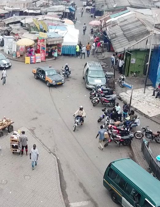
Cathedral Junction, the intersection of two major commuting arteries— Barnes and Castle Roads—is located between the Adabraka and West Ridge neighborhoods of Accra. The intersection functions mainly as a thoroughfare to major employment centers in the adjacent neighborhoods of North Ridge and West Ridge.
The intersection is surrounded by institutional and civic buildings, including the Holy Spirit Cathedral (the seat of Accra’s Roman Catholic bishop) located on the northwest corner. Eastward, two hospitals— Accra Psychiatric Hospital and Adabraka Polyclinic—along with a
medical training school, flank Castle Road. The Accra Rehabilitation Center sits at the southeast corner.
The intersection functions mainly as a thoroughfare to major employment centers in the adjacent neighborhoods.
The wide streets and large blocks surrounding Cathedral Junction reflect modern engineering standards that prioritize smooth vehicular traffic flows.
Cathedral Junction displays generally functional street and sidewalk infrastructure designed primarily for motor traffic. The multi-lane roads are well-paved with demarcated traffic lanes. Like Wato Junction, motor traffic lights are functional, and automobiles observe signals and traffic rules—motorcycles do not. The western and southern segments of Castle and Barnes Roads provide tree-lined pedestrian refuges. Sidewalks are generally evenly paved and free of trash.
However, as with Wato Junction, pedestrian infrastructure exhibits a low level of standardization and maintenance at Cathedral Junction. Although motor traffic lights are present and functional, there are only two pedestrian lights—one across Barnes Road and the other across Castle Road. They are either dysfunctional or out-of-sync with motor traffic lights. Sidewalks suffer from low levels of maintenance with obstructions such as broken drainage covers (on the east and south segments of Castle and Barnes Roads, respectively), rocks, and trees. The lack of ramps also poses a major challenge to access by the Cathedral intersection’s vulnerable populations. The variations in sidewalk width along road segments also indicate a lack of appropriate standardization. Similarly, the very thin pedestrian refuge on the north segment of Barnes Road creates danger for pedestrians crossing the road.
The distance between Cathedral Junction and the next intersection,
in all directions, is several hundred meters. As such, pedestrian jaywalking is exceedingly common in Cathedral Junction, as people would rather cross in the middle of the block than walk to the next corner. Though all four sides of the junction have significant mid-block pedestrian traffic, there is a midblock crosswalk only on the eastern segment of Castle Road. Most people crossing here are employees or patients of the hospitals, leaving to purchase food from stationary vendors in the morning or catch transportation in the evening. Some patients must cross from one side to the other to travel between medical appointments.
Public open space, in the form of wide curbs, is located on each corner of Cathedral Junction. Although these corners are largely unpaved, overgrown, and blocked by utilities and billboard columns, they are used by mobile vendors and pedestrians for congregation and respite.
On the northwest corner, mature trees offer pedestrians protection from the sun and rain. This corner has the most pavement of any at the Junction, allowing vendors to set up chairs and small tables on the even surface. However, billboards impede some pedestrian access to the sidewalk. Hawkers vend along the Barnes Road side of the corner during the morning rush hour.
At the northeast corner, open space is used primarily by pedestrians passing through the intersection. The open space beyond the sidewalk is unpaved and blocked by a line of billboard columns, making for an uncomfortable and inconvenient place to gather. However, farther eastward along Castle Road, a line of mature trees creates a comfortable location for stationary vendors to sell their wares throughout the day from semi-permanent stalls.
The southeast corner is distinct, and offers two options for pedestrian passage, with a sidewalk at street level and an unpaved walking path at a lower elevation along Castle Road. Small trees separate the sidewalk from the walking path, making the path the more comfortable and protected of the two spaces. Vendors congregate along this path, taking advantage of the wide space to also park their carts. Finally, although the southwest corner of the intersection is marked by overgrowth and billboard columns, it is used for access and congregation. Pedestrians walk across well-trodden paths in the weeds, and vendors have made seating out of the masonry walls. Along Castle Road, vendors use the utility poles to display their wares.
The roadway system at Cathedral Junction comprises two streets, both bearing two-way vehicular traffic. Its main north-south street, Barnes Road, branches off from arterial streets near the Kwame Nkrumah Interchange and carries traffic to and from the coast. The main east-west street, Castle Road, carries traffic to and from the Osu neighborhood to the west and the River Odaw to the east. Formal public bus lines travel along both Barnes Road and Castle Road, making stops past each corner of the intersection. Trotros and taxis also stop infrequently at the bus turnouts to pick up and drop off passengers. Pedestrian crossings at the intersection are set back past the turning radius of each corner. A midblock pedestrian crossing located eastward on Castle Road allows for pedestrian circulation between the Accra Psychiatric Hospital and the Adabraka Polyclinic. No bicycle infrastructure exists.
At the aggregate level, both vehicular and pedestrian traffic flows at Cathedral Junction are similar across the three peak periods. Around 65 vehicles per minute
flowed through the intersection (in any direction) and 5 pedestrians per minute made crossings at each sampled period (Figure 10).
Morning Peak Period. The morning peak period experiences significant southbound vehicle traffic along Barnes Road towards the Central Business District. According to the collected vehicle traffic count data, approximately 177 vehicles flowed per 10 minutes in the abovementioned direction. In contrast, the northbound vehicular traffic observed on Barnes Road was approximately 94 vehicles per 10 minutes. The highest vehicular traffic volume was observed eastwards on Castle Road at about 246 vehicle flows per 10 minutes, while the westward flow was approximately half that rate, at about 125 vehicles per 10 minutes. (Figure 14)
The observed pedestrian flows were less than one-tenth that of vehicle flows (Figure 10). On average, 35 pedestrians crossed Barnes Road during the 10-minute period, while 14 pedestrians crossed Cathedral Road over each 10-minute period.
Afternoon Period. Pedestrian and traffic flows are very similar in the morning and afternoon periods. The vehicle traffic count data show approximately 640 vehicles flowing per 10 minutes in the morning and 650 in the afternoon. The pedestrian flows are similar at approximately 50 pedestrians per 10 minutes in the morning and 40 pedestrians per 10 minutes in the afternoon. The direction of traffic is similar to the morning southbound pattern.
Evening Peak Period. In contrast with the morning, the evening peak period sees a reversal in vehicle traffic along Barnes Road in the northward direction with an average of 229 vehicles flowing per 10 minutes. The southward flow on Barnes Road is less than half that rate, at approximately 97 vehicles per 10 minutes. The
eastward vehicle flow on Castle Road was again higher than the westward flow, at 179 vehicles per 10 minutes and 159 vehicles per 10 minutes, respectively (Figure 15). During the evening, pedestrian flows across Barnes and Castle Roads were equal, with 25 pedestrian crossings occurring per 10-minute period on both roads. (Figure 16) Motorcycles, taxis, and tro-tros do not frequently park or stop in Cathedral Junction as it is mainly a thoroughfare and not a residential area. There are two bus stops with curb extensions that tro-tros, taxis, and private cars use temporarily, mostly for people accessing the hospitals. These transportation stops generate mid-block pedestrian traffic.
though less severe placement issue, as 22 percent of pedestrians choose to cross in front of the crosswalk.
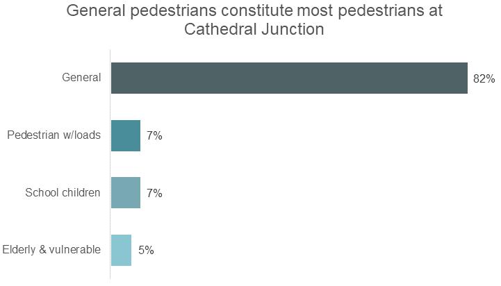
Using the same categories of pedestrians used for Wato, we find that general pedestrians constitute 82 percent of those walking at Cathedral Junction, while school children make up 7 percent, those carrying loads make up another 7 percent, and the elderly and the vulnerable comprise the remaining 5 percent. (Figure 11)
As previously noted, jaywalking is common at Cathedral. As many as 65 percent of pedestrians choose to cross mid-block. Of the pedestrians crossing between the north and south sides of Castle Road midblock, only 6 percent use the provided crosswalk. A full 71 percent of pedestrians walking along Barnes Road cross Castle Road in front of the crosswalk. The crosswalks across Barnes Road have a similar,
Unlike Wato Junction, the predominantly institutional land use around Cathedral Junction means that school children do not make up a large share of pedestrians crossing the intersection. There are only a handful of schools and educational programs in the vicinity of the intersection including Springboard School Osu, Adabraka Presby Basic School, Bethel Kids International School, Merton International School, and Accra High School. Land use layout and the predominance of private schools suggest that most children can commute to school without having to cross the intersection.
Although many persons with disabilities and elderly persons attend the church and hospitals in Cathedral Junction, many do so by car. However, those who do use the intersection must contend with several accessibility challenges. The crosswalk on the west side of Barnes Road is placed such that the tree in the median is in the middle of the crosswalk, creating a diversion for pedestrians. None of the crosswalks are wheelchair accessible, nor do they have non-visual or audible cues for the visually impaired.
Furthermore, many vendors carry carts or loads of wares through the intersection. The crossing distances are very long for slower pedestrians to make it in the allotted time. Additionally, motorcyclists often run red lights, putting all pedestrians at risk even those properly crossing the streets. Broken sidewalks and open sewers are hazardous for pedestrians—especially those in wheelchairs or with carts—but they do not cause pedestrians to detour onto roadways.
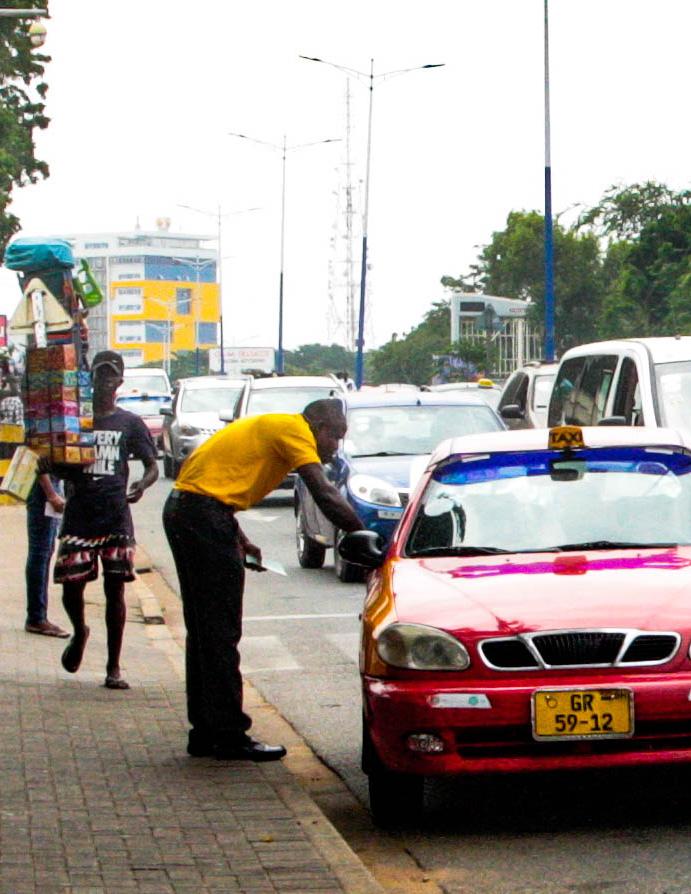
Cathedral Junction is a prime location for street hawkers. Although vendors were not included in the pedestrian counts crossing Cathedral Junction, they make up a significant share of the foottraffic in the intersection. The nature of vending in Cathedral Junction is shaped entirely by its function as a major commuting corridor. Vendors mainly target and sell to vehicle traffic. This pattern is evidenced by vendors’ goods and their selling strategy.
Vendors in Cathedral Junction are extremely mobile, usually carrying their goods and weaving in and out of lines of traffic stopped at red lights. As this is not a market center, they depend on impulse purchasing decisions from people passing in vehicles. They sell cold drinks, snacks, and small housewares. Vendors selling food comprise 43 to 55 percent of total market share with housewares claiming 25 to 29 percent. Street vending density increases throughout the day, presumably selling to homebound commuters and taking advantage of the afternoon heat to sell cold drinks and snacks. Despite their presence in the street during red lights, vendors do not contribute to traffic congestion or back-ups in Cathedral Junction. Vendors are quick to move out of the street when the light turns green, allowing vehicles to move freely.
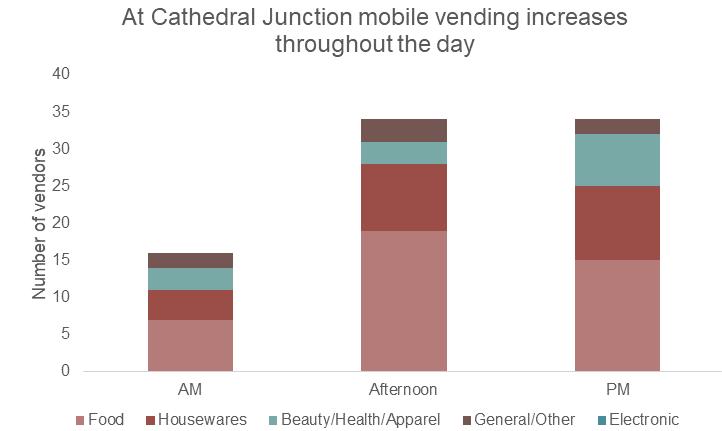
Stationary vendors mainly sell prepared meals (76 to 80 percent of market share) and tend to vend most heavily in the mornings and afternoons, selling breakfast and lunch to employees and visitors to the surrounding institutions. There are 2.5 times more stationary vendors in the morning and afternoon than there are in the evening. (Figure 12)
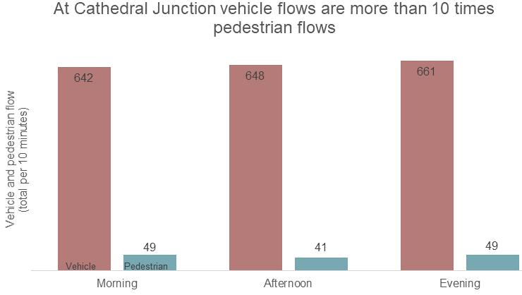 Figure 10. Source: Primary data collection (manual counts and drone footage)
Figure 11. Source: Primary data collection (manual counts)
Figure 12. Source: Primary data collection (manual counts)
Figure 10. Source: Primary data collection (manual counts and drone footage)
Figure 11. Source: Primary data collection (manual counts)
Figure 12. Source: Primary data collection (manual counts)
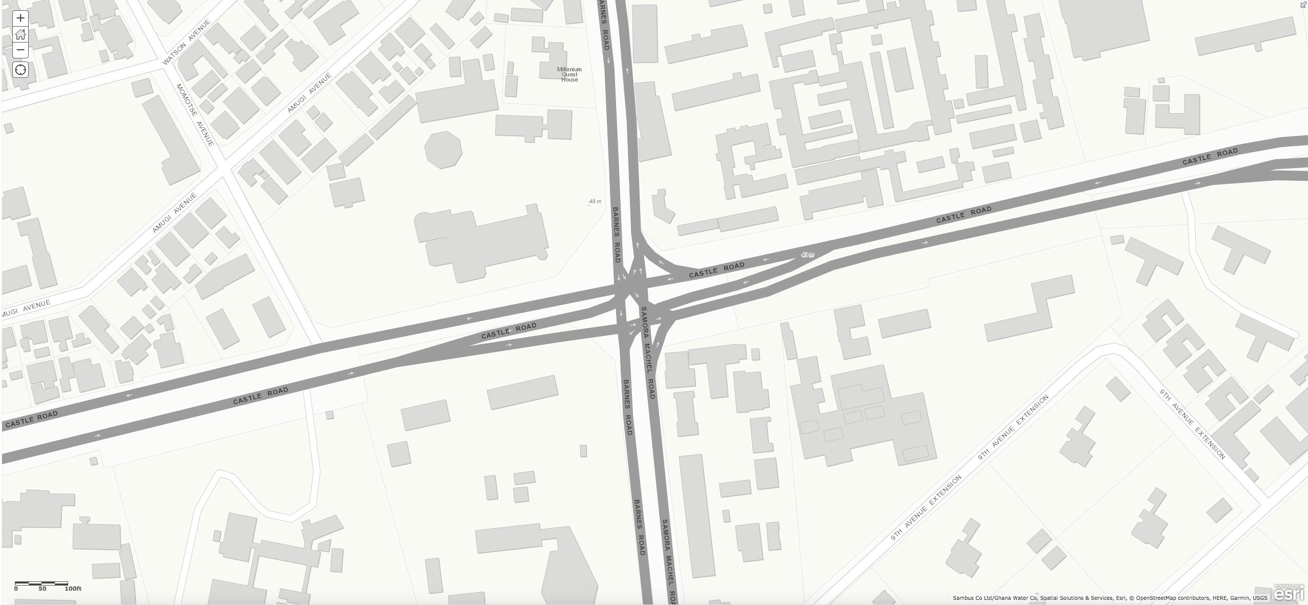 Figure 13. Morning Peak Period: Pedestrian Circulation
Figure 14. Morning Peak Period: Vehicular Circulation
1” = 100’
Figure 16. Evening Peak Period: Pedestrian Circulation
Figure 17. Evening Peak Period: Vehicular Circulation
1” = 100’
Figure 13. Morning Peak Period: Pedestrian Circulation
Figure 14. Morning Peak Period: Vehicular Circulation
1” = 100’
Figure 16. Evening Peak Period: Pedestrian Circulation
Figure 17. Evening Peak Period: Vehicular Circulation
1” = 100’
Although Cathedral Junction does not have heavy pedestrian flows, those who must cross do so at high risk. The main risk to pedestrians is the high speed of oncoming traffic. In addition, pedestrian signals are ill-timed, and crosswalks are not well-placed.
Pedestrian signals, while operational, are not timed correctly with traffic. They direct pedestrians to cross into oncoming traffic and to wait when it is safe to cross. When pedestrians cannot see turning vehicles nor trust the pedestrian signals, they take a gamble each time they cross the streets. During the Co-Lab, AMA officials pointed out that signal timing malfunctions often arise from power failures. Power loss results in signal timers being reset, which in turn causes the system to lose synchronicity.
Since the crosswalks are placed so far from the corner, pedestrians using the crosswalk are less visible to turning vehicles, and pedestrians waiting at the crosswalk similarly cannot see around the corners to check for turning cars. This diminished visibility makes crossing riskier. Many pedestrians choose to forego the crosswalks altogether because of their distance from the corner. However, this too has associated risks. Crosswalks are currently placed such that medians provide a shelter for pedestrians midway through the crossing. Those who cross closer to the intersection lose the valuable protection of the median.
Cathedral Junction puts vulnerable populations at certain risks, especially considering the intersection is home to two health and psychiatric institutions. The intersection has well-marked crosswalks and multiple medians to break up the crossing; however, it also has several accessibility issues, as noted in the sections above.
The mid-block crosswalk that connects the hospitals on either side of Castle Road does not sufficiently protect pedestrians. Road signs and a painted crosswalk warn drivers of pedestrian crossings but do little to slow oncoming traffic. Moreover, the crosswalk does not line up across the median, so pedestrians must walk along the narrow median strip if they wish to stay within the painted area while they cross. The narrowness of the median makes it difficult for several people to cross at once, and a pole in the median obstructs the path between the two sides of the crosswalk. The crosswalk is not wheelchair accessible, which is problematic for hospital clientele.
Similar to Wato Junction, motorcycles pose one of the greatest risks to pedestrians in Cathedral Junction. They frequently weave through stopped traffic, disobey red lights, travel against traffic patterns, and come up on sidewalks, seriously endangering pedestrians. They impose a heightened threat to hawkers who take advantage of stopped traffic to sell their goods. Often, motorcyclists travel in between traffic lanes where hawkers, who are selling, may not be able to see them coming.

Chapter 3
Through observations and interviews, the WWS team collected information on the demographics, commercial activities, and well-being of vendors at both Wato and Cathedral Junctions. Vendors maintain important roles at both locations, serving public demand for low-cost goods and services, supporting formal economic actors, and maintaining the public way. However, vendors face numerous challenges to their physical and financial well-being due to the nature of their work. Of note, while the experiences described here are likely representative of those of many of Accra’s informal vendors, they are drawn exclusively from the limited number of vendors observed and interviewed by the WWS team.
Accra’s informal vending community boasts diversity in terms of socioeconomic status, gender, age, and educational attainment. Interviewees ranged from young teenagers to elderly people who have worked as vendors for up to 20 years. Most observed vendors were women, some of whom are single parents, whose households depend entirely on their income from vending. Many vendors interviewed migrated to Accra from Ghana’s northern regions, while others traveled from nearby locations such as the Ashanti Region. Some are Accra natives whose families’ indigenous roots date back to the colonial era; others are the first in their families to arrive in Ghana from neighboring countries such as Niger and Nigeria.
 Vendors sell their goods to passing traffic at Wato Junction.
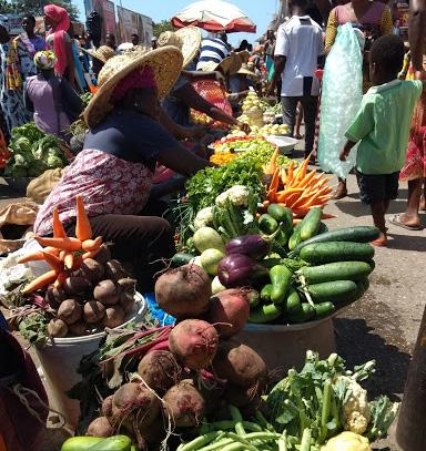
Vendors sell produce at Makola Market.
Vendors sell their goods to passing traffic at Wato Junction.
Vendors sell produce at Makola Market.
Most observed vendors were women, some of whom are single parents, whose households depend entirely on their income from vending.
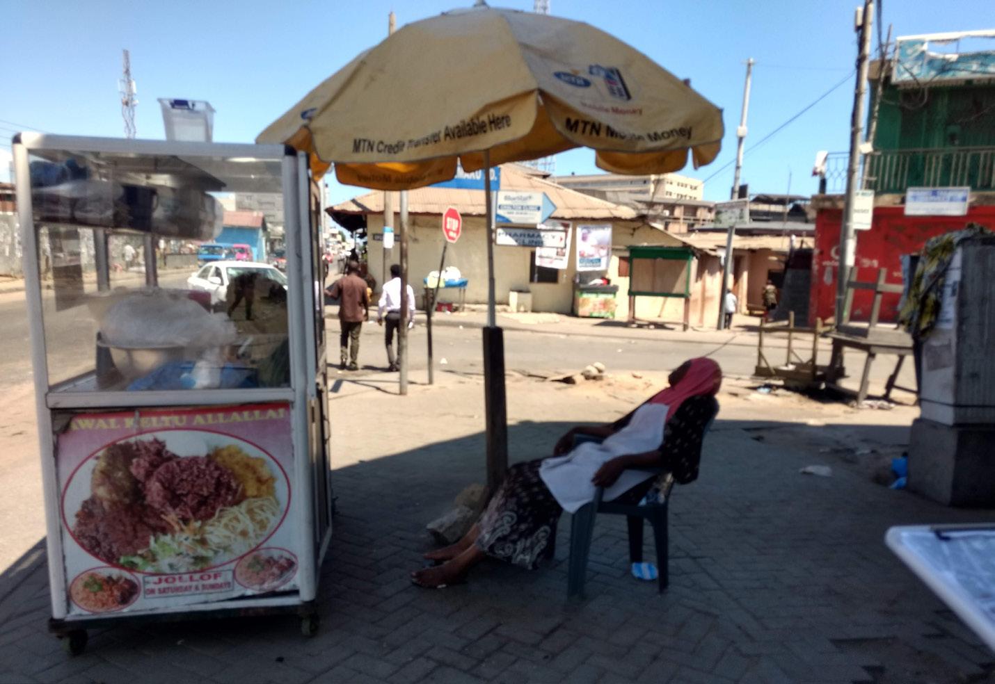
Street vending is best understood in two categories: stationary vending and mobile vending. Stationary vending involves selling goods from a fixed location along a sidewalk or median. Some stationary vendors sell from stalls complete with wooden structures and coverings to protect their products; others may provide customer seating, typically accommodating up to three patrons at a time.
In contrast, mobile vendors move about the road, selling directly to drivers and passengers stopped at traffic lights. The most prevalent categories of mobile vendors are hawkers, cart vendors, and head porters, also known as kayayei. Mobile vendors usually maintain a space adjacent to the road to organize their products and replenish their wares as they make sales throughout the day. Other vendors sell products from mobile carts, typically carrying items from a single company.
At Wato Junction, both stationary and mobile vendors sell to a mix of pedestrians and passing vehicle traffic, with some walking into the roadway to sell to stopped cars and tro-tros. Vendors in Cathedral Junction, meanwhile, are predominantly mobile, carrying their goods and weaving between lines of stopped traffic. These patterns are reflective of the intended uses of each junction; Wato exists as public space with high foot traffic, while Cathedral functions as a major commuting corridor that promotes mobile vending.
As identified in previous sections, both fixed and mobile vendors sell a range of products including food and drink, apparel, and
home supplies. It is common for vendors to vary the products they sell throughout the year as they adapt to market demand, adjust to the seasonal availability of certain goods, and seek products with higher profit margins. It is unclear based on the collected data which forms of vending, or which types of goods, are the most profitable.
The workday for informal street vendors varies, but most begin their work between 5:30 AM and 7:30 AM. Most interviewed vendors end their days between 4:30 PM and 7:00 PM, after the evening rush hour.
At Wato Junction, the highest density of mobile vending occurs in the morning when mobile vendors, usually selling food, travel from James Town in the south and move northward. The number of mobile vendors gradually decreases throughout the day, and the flow of movement reverses as people make their way back towards James Town in the afternoon and evening. Stationary vendors tend to increase in number throughout the day, with the evening experiencing
more than double the number of vendors as the morning. Vendors tend to sell in more spacious areas where pedestrians can easily access their stalls (Figure 19).
By contrast, mobile vending density increases throughout the day at Cathedral Junction, where mobile vendors take advantage of the afternoon heat to sell cold drinks and snacks to homebound commuters in the evening.
Stationary vendors at Cathedral tend to sell most heavily in the mornings and afternoons, selling breakfast and lunch to employees and visitors to the surrounding institutions. The team observed 2.5 times more stationary vendors in the morning and afternoon than during the evening hours.
The level of informal vending activity at Wato and Cathedral Junctions is affected by the weather and the amount of traffic on a given day. For example, there is lower economic activity at both intersections on rainy days, as the inclement weather reduces the number of potential customers. Similarly, low traffic flows reduce the number of drivers and passengers who buy from hawkers.
Wato and Cathedral Junctions are home to complex economic ecosystems comprised of formal business owners, vendors, suppliers, and customers. There are many types of relationships, detailed below, maintained by informal vendors with other economic actors at each intersection. These relationships vary in terms of the nature of commercial arrangements and in terms of the level of trust and acceptance involving vending activities.
Customers come in many forms at both intersections. They are pedestrians commuting to and from work; they are leisurely passersby; they are drivers or passengers stopped at traffic lights; they are shop owners and other vendors who purchase refreshments while working. All of these actors express a demand for vendors’ goods; they are also present in different concentrations at each intersection. Vendors were observed selling to tro-tro drivers and passengers with greater frequency at Wato Junction, given the higher number of tro-tros which pass through Wato. Similarly, transactions involving shop owners and other vendors are more common at Wato Junction than at Cathedral Junction due to the dearth of retail in the Cathedral area.
The WWS team observed vendors engaging in both transactional and non-transactional interactions with one another. Transactional interactions between vendors include the purchase of one another’s goods; vendors also rely on other vendors for the inputs or storage spaces they require to run their businesses.
Vendors were also observed supporting one another in a nontransactional manner, as would any group of colleagues. The WWS team found that it is common for vendors to leave their products unattended for periods of time (to use the restroom or replenish their wares) under the assumption that other vendors would watch over their belongings. Vendors also provide a source of comfort and entertainment for one another throughout the day.
The interviewed vendors source their products from a variety of actors in the formal economy. Many purchase their goods in bulk from vendors or wholesalers stationed in markets. Others source their products from more formal businesses or multinational corporations. Vendor relationships with large corporations vary significantly. The WWS team identified many vendors who purchase a specific company’s goods in bulk to sell for a higher price on the street. However, other vendors have more formal relationships with private companies. One company, FanMilk, provides vendors with a cart and a set of products to sell in exchange for a fixed profit (awarded only to
vendors who sell all of their stock each day). The interviewed vendors who sold for FanMilk are not under contract and could transact with them at will. Other companies engage more formally with vendors; for example, Galaxy, a company that produces soya milk, hires vendors by application in exchange for monthly compensation, free accommodation, and water.
Many vendors reported that they maintain supportive relationships with property owners at each Junction. Property owners grant stationary vendors permission to establish fixed stalls in front of their buildings and on their lands. Some landowners charge vendors for the right to sell on or in front of their properties, while others extend such a benefit free of charge. Landowners may also offer overnight storage services to vendors.
However, some vendors reported contentious relations with property owners, particularly at Wato Junction. Some shopowners reportedly take issue with vendors selling outside of their stores, as vendors take up space or obscure their businesses.
Vendors support one another in a non-transactional manner, as would any group of colleagues.
Many stationary vendors interviewed by the WWS team have sold their goods in the same location for several years. This permanence is possible when stationary vendors inherit their vending locations from parents or other relatives. Older generations typically develop relationships with landowners that pass down the permission to sell in a given location in the event of retirement or death.
Cathedral Junction benefit from long red lights, traffic backups, and high vehicle flows, as they require high volumes of stopped traffic to sell effectively. Meanwhile, several vendors, primarily at Wato Junction, recounted how they value their vending space because of the easy access to bathroom facilities, food options, and the company of other vendors. These amenities offer vendors a semi-comfortable and convenient workspace.
Despite the physical advantages of vending at Wato and Cathedral Junctions, both spaces have limitations that hamper vending activity. Vendors at Wato Junction contend with damaged, flooded, or tilted sidewalks. Guardrails also limit their movement and trap them against traffic flows when they enter or exit the motorway. In Cathedral Junction, the biggest challenge facing vendors is the danger imposed by motorcycles that weave through stopped traffic where vendors are selling. Additionally, although stationary vendors at Cathedral Junction benefit from ample sidewalk space to display their goods, they do not see large flows of pedestrian customers.
Vendors face an unclear legal and regulatory framework. The AMA’s by-laws prohibit unregulated street hawking and selling on pavements: AMA by-law VII states that “no person shall offer for sale or sell any article in a street market other than in the space for selling allocated to him by the AMA.”¹⁰ This law indicates that there are designated spaces for street hawking and vending in Accra. However, the majority of vendors the WWS team spoke with are not permitted by the AMA, and it seems that rules are arbitrarily enforced and poorly regulated.
However, these relationships are not required for informal vendors to establish a selling space. As per the WWS team’s interviews, new vendors are free to make their own decisions about where to sell, and their claims to a location are generally respected. However, it is unclear what happens when a claim to a location is disputed, and if the process of claiming a space is different for mobile and stationary vendors.
Aside from those who inherited their vending locations, vendors cited sales potential and amenities as the primary reasons why they sell at a given location. Importantly, vendors prefer locations with functional traffic infrastructure. Vendors at
Vendors in both intersections were observed treating their selling spaces with care and attention to cleanliness. Early in the morning, stationary vendors at both intersections sweep the streets and sidewalks around their stalls. At Wato Junction, the WWS team observed that a group of hawkers put out a large trash can each day to collect their own trash and that of passers-by. At the end of the work day, most vendors clean their vending spaces, picking up trash and any excess wares. Interestingly, these observations seem to contradict the common perception of informal vendors in Accra as street polluters.
As a result, the relationship between vendors and city authorities is tense. Many vendors reported that AMA officials and police have evicted them from their vending spaces and confiscated their goods. Stationary vendors experience evictions more frequently than head porters and hawkers; however, the WWS team did observe one verbal altercation between a head porter and a police officer. Despite these altercations, vendors reported returning to the same vending spaces regardless of AMA eviction policies and have systems in place to hide or protect their wares when AMA officials arrive. Some vendors did note that AMA attempts to remove vendors from public spaces have decreased in recent years.
A review of the literature indicates that while Ghana’s Department of Labor and National Labor Commission are mandated to receive complaints from workers, trade unions, and employers, most informal vendors find it challenging to pursue legal action against the AMA unless they can afford counsel.¹¹
Moreover, labor laws are not clearly applicable to informal workers, and informal vendors are less likely to organize and form unions than other categories of workers. As such, vendors are highly susceptible to abuse and exploitation by city officials and private companies.¹²
Sales potential and amenities are the primary reasons for location choice.
Vendors face numerous challenges to their financial, physical, and emotional well-being. Most vendors reported their income as highly variable and barely sufficient to cover their basic costs of living. It is clear that vendors are among the poorest citizens in Accra, with many of them living in informal settlements and subsisting on very basic diets. Furthermore, vendors expressed that they face difficulty in accessing capital to maintain or expand their businesses. Despite these challenges, some vendors reported that they earn enough to periodically save money, either independently or using informal savings and loan programs (locally known as “susus”).
Vendors at Wato and Cathedral Junction do not appear to have meaningful access to formal social safety nets. For example, though some vendors described their enrollment in Ghana’s nationalized health insurance plan, they noted that they do not use health services due to the extra costs associated with hospital visits, tests, and medication. Many vendors reported that they never fall sick, i.e. they cannot afford to forfeit any income due to illness and do not have plans in place if confronted by a serious health emergency. It also appears that vendors lack access to life, accident, or property insurance. Many vendors interviewed are widows, who began vending after the death of a spouse. Others began vending after the loss of their formal business to fire, for example.
Moreover, street vending is physically taxing. Vendors spend most of their time on their feet, burdened by heavy carts or loads carried on their heads or shoulders. Many vendors exhibited poor posture, and some reported that they experience daily joint and body pain. Meanwhile, though many vendors (particularly those at Wato Junction) reported that they feel comfortable and safe maneuvering through traffic as they sell their goods, vendors face a higher risk of traffic accidents than the general population due to the nature of their work.
 A vendor carries water sachets to her stall. Heavy loads contribute to vendors’ poor health.
 @ 2018, Kimberly M Noronha (All rights reserved)
“While there are potential areas for improvement, the intersections are largely functional spaces that accommodate traffic and pedestrians in dynamic, thriving, and self-sustaining ways.”
 Chapter 4
The findings from the spatial/traffic and vendor data collected by the WWS team provide an opportunity to draw insights about the elements of spatial and policy design that are currently supporting vendor livelihoods, helping to manage effective traffic flows, and facilitating pedestrian safety at Wato and Cathedral Junction. Overall, even when there are potential areas for improvement, the intersections are largely functional spaces that accommodate traffic and pedestrians in dynamic, thriving, and self-sustaining ways.
Wato Junction successfully serves multiple functions as a vibrant community space. Wato Junction serves as both a community destination and a thoroughfare. The intersection maintains a vibrant network of vending activity; neighbors gather in public spaces to converse with each other and buy snacks and goods from vending stalls. Wato is also a place of historical importance. Institutions like the Wato Club connect the Junction’s past to its present and provide spaces for social and communal gathering. At the same time, Wato serves as a transportation hub for passengers leaving and arriving in tro-tros, moto taxis, and private vehicles. Thus, Wato Junction is operating successfully both as a conduit to the rest of the city and as a space for communal and economic activities.
Both intersections provide basic pedestrian safety infrastructure. Both Wato and Cathedral Junctions have sidewalks for pedestrian use, painted crosswalks, and pedestrian crossing signals. The wide and low median on the eastern side of Castle Road provides space for vendors to safely wait for cars and to quickly get out of the way of traffic when the light turns green.
The medians on all sides of the intersection provide shelter for crossing pedestrians. At Wato Junction, traffic islands provide safe spaces for pedestrians crossing the intersection. These spaces are extremely valuable for vendors and other pedestrians. Nonetheless, their design could be improved significantly (as elaborated upon in Chapter 6).
Both intersections have smooth traffic flows despite vendor presence. Both Wato and Cathedral Junctions handle traffic congestion well, with minimal traffic backups. With the notable exception of motorcyclists, drivers obey traffic signals, enabling the intersections to function safely and efficiently for vehicles. Cathedral Junction, which receives more vehicular traffic, is particularly well designed for handling large vehicle volumes. Though it experiences moderate backups in southbound lanes during the morning rush period, for the most part traffic moves quickly and efficiently through the intersection. There are no significant traffic backups during the evening rush period, even though this period has the highest level of vendor presence. Wato Junction, with relatively less vehicular traffic, also supports fairly rapid and efficient traffic flows through the intersection, despite its complicated structure. Contrary to common perceptions, our observations did not indicate that vendors impede traffic flows. They enter the street space when cars have stopped at traffic lights and vacate before the lights turn green. Thus, vendors are providing a convenient service to drivers on their evening commute without contributing to traffic congestion.
Vendors generate and enhance economic activity at each intersection. Vendors operate as suppliers and consumers of different goods and services in the intersections, emblematic of the symbiotic relationship that exists between formal and informal economic actors in Accra. Vendors retail for large companies and store owners, making products available to pedestrians and vehicles passing by. They also sell to other vendors and to salespeople in nearby stores. They also patronize local businesses when they buy food at the intersections and pay for access to services like bathrooms and storage facilities.
The vending value chain functions well. Vendors at both intersections report ready access to storage spaces, wholesalers, and other upstream service providers in and around the intersections. In addition, strong relationships amongst vendors form the basis of an informal vendor support community (e.g. vendors watching other vendors’ goods and sharing resources). As a result, the flow of goods from manufacturers and wholesalers to consumers at the intersections is smooth, with minimal theft and loss along the way.
Vendors care for their workspace in ways that contribute to the city’s resilience. Vendors value cleanliness in their vending environments and, at Wato and Cathedral Junctions, provide a significant service to Accra’s public sanitation. We observed vendors providing waste collection and street cleaning services at each intersection.
To better support the dynamic relationship between vendor activities, traffic, and other spatial uses of the intersections, it is important to acknowledge various elements of each space that limit vendor livelihoods, curtail effective traffic flows, and compromise pedestrian safety. There are significant pedestrian and vendor safety issues at both Wato and Cathedral Junctions that need to be addressed. Additionally, vendors at each site face numerous challenges related to their overall well-being. Clarifying the dimension and scope of these areas for improvement is key to ground potential recommendations that reflect the need, urgency, and process for change.
Both intersections present a dangerous environment for pedestrians. There is insufficient space and protection for pedestrians at Wato and Cathedral Junctions.
Limited sidewalk space at Wato Junction is insufficient to accommodate the high volume of pedestrian traffic, forcing pedestrians onto the roadway and encouraging unsafe behaviors like jaywalking. Obstacles such as pedestrian guardrails, motorcycle parking, construction debris, and poor sidewalk maintenance also block sidewalks, corralling pedestrians into the unsafe center of the intersection. Street hawkers face particular difficulty in accessing sidewalks from the roadways where they vend. While Cathedral Junction has sufficient sidewalk space on the outer edges of the intersection, there is insufficient protection for pedestrians wishing to cross. Crosswalks are ill-placed, without wheelchair accessibility, and with physical obstacles such as trees and billboards. These issues discourage the use of designated
crosswalks. Sidewalk barriers also disincentivize the use of sidewalks by vendors pushing carts or carrying heavy loads.
Moreover, rash driving by motorcyclists puts everyone at risk. Motorcycles drive through the pedestrian traffic islands at Wato Junction and make other unpredictable maneuvers that are difficult for pedestrians to avoid. The danger posed by motorcycles weaving through traffic lanes is also a major safety challenge facing vendors in Cathedral Junction.
Physical infrastructure is poorly maintained at both sites. While vehicle signals are maintained at both intersections, several pedestrian signals at Cathedral Junctions are uninstalled, do not function, or are out-of-sync with traffic signals—posing serious threats to pedestrian safety. Pedestrians at both intersections cannot see around turning lanes to check for oncoming vehicles. Pedestrian light phases are also too short for slower-moving pedestrians to cross the wide, high-speed roads at Cathedral Junction and to accommodate the very high pedestrian volumes at Wato Junction. Furthermore, poor street lighting at both intersections makes it difficult for drivers to see pedestrians at dark hours. This problem is particularly acute at Wato Junction, where the evening rush period sees thousands of pedestrians crossing the streets. Improving pedestrian signals and street lighting could have significant benefits for pedestrian safety.
Other broken or missing infrastructure hampers safety and cleanliness at both sites. Sidewalks are broken, slanted, or obstructed in many locations throughout Wato
and Cathedral Junction, presenting trip hazards and forcing pedestrians and vendors into the roadway. Additionally, the WWS team did not observe any public trash cans or other waste management infrastructure at either intersection (beyond those provided by vendors).
Vendors face vulnerabilities in their economic and physical well-being. Many vendors report that their vending activities provide barely enough income to cover their family expenses. Several expressed the desire to sell a higher quality product or own a formal stall, but lack the capital to expand their businesses. Moreover, vendors have little access to formal social safety nets, and vendors are unaware of the social protection programs for which they are eligible.
Moreover, vendors engage in strenuous and dangerous work. Most vendors work long hours and put physical strain on their bodies by standing for extended periods of time, carrying heavy products on their heads or pushing heavy carts. For street hawkers, particularly in Cathedral Junction, there is the added danger of working amidst moving traffic.
Street vendors’ relationships with authorities are strained and fraught with tension. Even though vendor-AMA relations have reportedly improved in recent years, vendors still live in fear of eviction or product confiscation by the AMA. Additionally, there is confusion as to the legal framework and taxation policies faced by informal vendors, which creates inefficiencies in policy response.
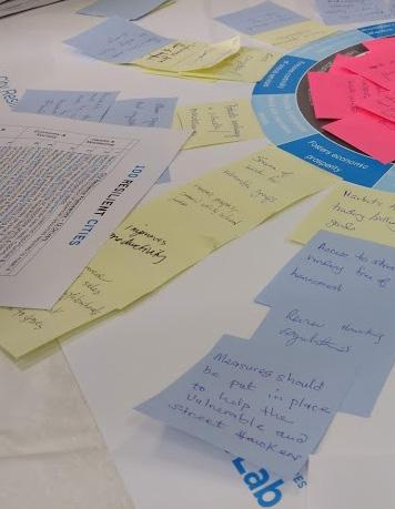
Chapter 5
“The specific proposals suggested by the Co-Lab teams and the additional logistical, political and financial constraints that participants shared framed the WWS team’s thinking about the policies recommended.”
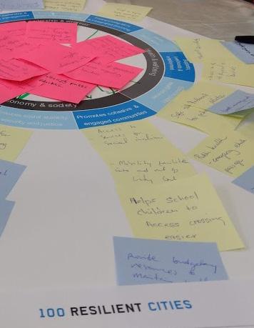
The WWS team presented many of the above findings to the participants of the Co-Lab hosted by 100RC on November 1-2, 2018 at the AMA Headquarters. The Co-Lab involved both facilitated discussion and presentation activities among tables of different stakeholder groups. To encourage cross-sectoral collaboration, each table contained government officials, local NGO representatives, international experts, WWS team members, and 100RC staff. The groups were first asked to prioritize resilience challenges in Accra. Then, they were asked to brainstorm potential initiatives to address high-priority gaps and create a shortlist of initiatives via voting. Finally, participants formed new teams around the shortlisted initiatives based on their interests and expertise, refined the shortlisted initiatives, and presented their initiatives to a panel of senior AMA officials.
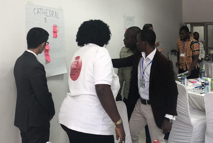
Proposals broadly fell into three categories:
1. Redesigns or upgrades of Wato and Cathedral Junctions;
2. Initiatives to organize or formalize vending; and
3. Placemaking strategies for Wato Junction
Further details of the proposed projects are listed on the opposite page. The specific proposals suggested by the Co-Lab teams and the additional logistical, political and financial constraints that participants shared framed the WWS team’s thinking about the policies recommended in the following chapter.
The Co-Lab provided an opportunity for the WWS team to learn about some of the constraints on the AMA and other stakeholders in implementing new policies. The team noted that:

Decentralization of the AMA’s responsibilities to local councils makes city-wide policies more difficult to coordinate and implement. Therefore, place-based policies and those that come under the national government directive will be easier to implement in the short-term than those which will require consensus-building and stakeholder engagement across several councils.
Divergent views among the stakeholders about the role of the AMA vis-à-vis vendors revealed that any major change to existing vendor policies may meet with heavy resistance. Some participants approach vendors with the goal of regulating and controlling vendor behaviors, which may make vendors’ circumstances more precarious. Others would prefer to empower vendors by providing legal protections for their work. Both strategies can generate similar policies, such as new permit or licensing schemes. It should therefore be recognized that such policies could ultimately serve to undermine or strengthen vendors’ position and that any eventual policy changes should be vetted thoroughly by vendor stakeholders to ensure that the stated goals are being achieved.
Serious financial constraints limit the scope of intervention that can be pursued without additional outside funding, underlining the importance of prioritizing policy objectives.
Co-Lab participants discuss resilience challenges at Cathedral Junction. Stakeholders design a new Wato Community Center, one of the ideas generated from the Co-Lab. @ 2018, Kimberly M Noronha (All rights reserved)The following provides a summary of policy and design solutions generated by stakeholders at the 100RC Co-Lab. The Co-Lab produced action items for the AMA to confront transportation and livelihood challenges at Wato and Cathedral Junctions and Accra more broadly. The WWS team has incorporated the most promising and pressing elements of these solutions into its final recommendations.
Redesigns or upgrades of Wato and Cathedral Junctions
The AMA could undertake a redesign of pedestrian routes and crossings in Wato and Cathedral Junctions to reduce public safety risks and traffic vulnerabilities.
The AMA could undertake a street and traffic light solarization program to improve road safety, focused especially on high traffic intersections like Cathedral Junction. This program would involve the installation of reliable solar lighting, and the regular evaluation and adjustment of traffic and pedestrian light sequencing to eliminate overlaps in green signals for vehicles and pedestrians.
Initiatives to organize or formalize vending
The AMA could develop a municipality-led engagement strategy with street vendors, in partnership with vendor support organizations. This process would gather information about vendor needs, facilitate connections between the AMA and vendor representatives, and establish a regular forum for communication on relevant policy planning between vendors and city officials.
The AMA could establish a municipal permitting system for vendors that offers formal recognition of the vendor occupation, and provides incentives to permitted vendors to maintain trading within designated locations, cleanliness in public spaces, etc.
The AMA could collaborate with vendor support NGOs to facilitate the development of a union or federation for street vendors to help improve their business skills and incomes, inform vendors of their rights, and advocate for laws and regulations on their behalf.
Placemaking strategies for Wato Junction
The AMA could engage in communication efforts to raise awareness about the value of Wato Junction as a place (and not simply as an intersection). The AMA could develop a place branding strategy for the Junction that increases awareness of the area’s cultural and historic assets. The strategy could encourage pride and responsibility for maintaining Wato’s public areas.
The AMA could redevelop the Salaga Market (in Wato Junction) and adjacent car park as a multi-functional public space for recreation, vending activity, and other revenue generating activities, restricting traffic in this area.
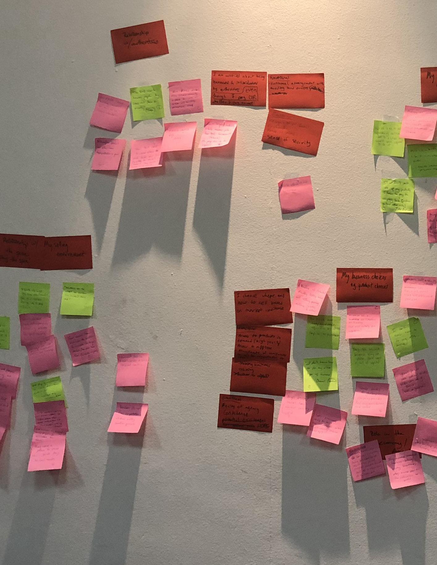
The AMA and 100RC envision an Accra in which transportation corridors are characterized by harmonious relationships between traffic, pedestrians, and vendors. Such harmony is critical to Accra’s public safety, economic development, and overall resilience. To achieve this vision in Wato and Cathedral Junctions, and in Accra more broadly, the WWS team has developed a set of design and policy interventions intended to support traffic flows, pedestrian safety, and vendor livelihoods. The recommendations seek to optimize the intended functionality of both intersections: Wato as a community space, and Cathedral as a major commuter node. The WWS team’s recommendations incorporate several aspects of the proposals that emerged from the Co-Lab process, including specific design elements and policy objectives, as well as associated constraints and political challenges.
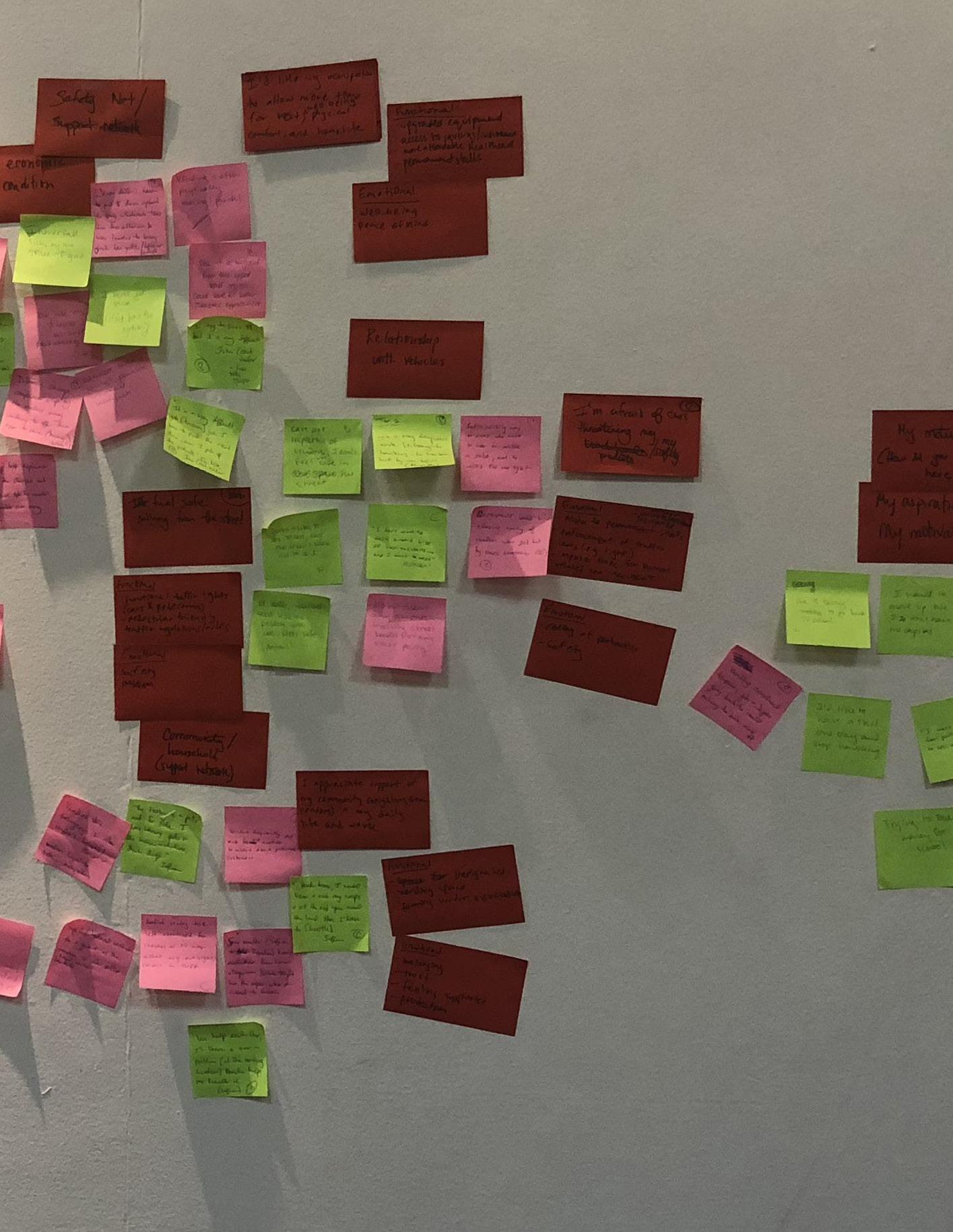
Since Wato Junction is primarily used by pedestrians, the potential design interventions for this intersection aim to improve pedestrian safety and walkability using traffic calming measures to reduce pedestrian exposure to vehicular traffic. By reclaiming strategic portions of the roadway to extend sidewalk widths, the design interventions below actually ease traffic congestion by moving pedestrians through the intersection more quickly, allowing for shorter light cycle times for vehicles.
Extend or reconfigure curbs and traffic islands: Curb extensions (also called bulb-outs) and traffic island expansions increase the width of sidewalks at street corners and pedestrian crossings to accommodate the volume of pedestrian traffic during rush hours and to reduce the number of vehicular traffic lanes pedestrians must cross.
Remove pedestrian barriers: Sidewalk improvements and the removal of construction debris from sidewalks will allow pedestrians to stay on the sidewalks rather than being redirected into the street and oncoming traffic.
Replace pedestrian guardrails with bollards: Guardrails create bottlenecks for crossing pedestrians that can be alleviated by widening gaps in the railing or replacing all or part of the railing with bollards. Bollards prevent vehicles from accessing the sidewalk while allowing pedestrians to flow more freely. Bollards would also enable street hawkers to access the sidewalk more quickly when the light turns green, making their activities safer.
Reduce turning lane blind spots: Moving the crosswalk on the southwest corner to the corner’s edge will reduce the risk of turning vehicles striking crossing pedestrians.
Lengthen pedestrian signal time: Extended pedestrian signal times, especially for those crossing Asafoatse Nettey Road, will enable pedestrians to cross more safely by reducing the need to cross against the signal. The pedestrian phase can be lengthened even more during the morning rush hour when east-west traffic on Asafoatse Nettey Road is light.
Scatter walk: This option adds a phase to the light cycle in which all vehicle traffic is stopped and pedestrians can cross in all directions. This process allows pedestrians to cross multiple lanes quickly and safely and removes bottlenecks at certain corners.
Install street lights: This will improve visibility at night, making it easier for drivers to see pedestrians. Well-placed pedestrian lights could also contribute to placemaking efforts.
Designated motorcycle parking: Creating designated motorcycle parking that allows access to all parts of the intersection will disincentivize motorcyclists from breaking traffic laws and putting pedestrians at risk.
Designated tro-tro stops: Incorporating the existing unofficial tro-tro stops into any redesign will ensure that the stops are in optimal locations to minimize pedestrian and traffic risks.
Because Cathedral Junction is primarily a vehicular thoroughfare, the potential design interventions for this intersection aim to improve pedestrian safety and walkability through traffic calming, while maintaining enough width to avoid creating traffic congestion. Furthermore, the selected design interventions below account for future urban planning needs, such as the city’s bus rapid transit (BRT) system, using a phasein strategy that addresses short-, medium-, and long-term planning.
Move crosswalks to corner edge: Placing crosswalks on the corner edge improves the visibility of vehicles to pedestrians and vice-versa. They facilitate pedestrian use by removing circuitous routes to reach the crosswalk.
Extend or reconfigure curbs and medians: Curb extensions improve pedestrian safety by slowing turning traffic and reducing the overall distance pedestrians must cross. Median extensions towards the intersection will provide refuge for pedestrians crossing at the corner edge and will slow turning traffic, making the crossing safer. To allow for continued refinement and modularity, curb and median extensions could be accomplished initially via bollards, with extension of the raised concrete curb coming only after validation and finalization of the design.
Make medians and corners accessible: Curb cuts should be added to all corners and medians to make the crosswalks at corners and the hospital crossing entirely wheelchair accessible. This measure is particularly important for hospital patrons who use the intersection, and for vendors carrying heavy loads or pushing carts.
Raised crosswalk at hospital crossing: Essentially a very wide speed bump, this option automatically slows vehicle traffic and improves pedestrian visibility to make a safer passage for pedestrians.
Improved signal functionality: Pedestrian lights require reconfiguration so that they correctly signal when it is safe to cross. Adding power back-up or solar panels to the signaling system will ensure that pedestrian signals do not get outof-sync with traffic signals in the case of a power outage.
Install new pedestrian street lighting: Currently, poor street lighting causes low visibility at night and poses a danger to motorists and pedestrians. Installing pedestrian lighting—street lamps designed to light sidewalks instead of roadways—at pedestrian crossings will help vehicles identify pedestrians before they step into the roadway.
Flashing pedestrian light at hospital crossing: Adding a pedestrian button that activates flashing lights to alert drivers of pedestrians at the hospital crossing will improve pedestrian visibility and make the crossing safer.
Create dedicated lanes: In line with the integrated mobility plan, dedicated lanes should be added for BRT, bicycles, and/or other prioritized modes of transport as relevant. To make way for these lanes, the AMA could reclaim land where adjacent property owners have encroached and/or purchase unused land (e.g. from Museum Board) in surrounding areas. Dedicated lanes improve travel speeds for prioritized modes of transport, in turn driving travelers towards those modes and improving congestion and environmental performance.
These select few potential design interventions prioritize the most vulnerable users to foster inclusive urban planning. Drawing from the urban design literature, the following design principles informed the WWS team’s proposed interventions:
1. Cater to all users’ needs: Intersection design should cater to all users’ needs, including pedestrians, persons with disabilities, vendors, tro-tros, public transit, private vehicles, and motorcycles.
2. Manage vehicle input and exit: Intersection design should limit prolonged vehicle input-exit imbalances that give rise to congestion.
3. Reduce pedestrian exposure: Intersection design should shield pedestrians from vehicle traffic to the extent possible via appropriate sidewalk design, signal installation, and maintenance.
4. Increase driver awareness: Intersection design should increase driver awareness of pedestrians and other drivers via signal installation and maintenance and traffic calming measures.¹³
Due to their presence in the public right of way, vendors face a higher risk of accidents than the average pedestrian. We thus expect that these design improvements will benefit vendors in particular.
Drawing from the research findings and the ideas generated by the 100RC Co-Lab, the WWS team developed the following set of policy recommendations which could help to solidify efforts to improve traffic flows, pedestrian safety, and vendor vulnerability throughout Accra. In many cases, these recommendations do not offer concrete solutions but mechanisms through which relevant stakeholders may convene to arrive at specific policy conclusions after sharing relevant information and perspectives.
The AMA Department of Transport should build on the Ghana Urban Mobility and Accessibility Project in coordination with other ministries, departments, and agencies by developing an Integrated Mobility Plan for the city. Integrated Mobility Plans seek to provide a coherent approach towards urban mobility, catering to the current and future needs of the population. They also strive to ensure social inclusion by improving access to low-cost transport services, increasing system sustainability, and facilitating better coordination of transport services. In Accra’s context, such a plan implies coordinating the development and regulation of different modes of transport such as buses (and the new BRT system) and informal transports including tro-tros. It also entails broadening the lens of mobility from predominantly the vehicle perspective to including pedestrian needs—for example, improving road crossings and the walkability of sidewalks for pedestrian safety.
Create a comprehensive public space program that prioritizes social inclusion
After assessing existing public spaces, the AMA should establish city-wide goals for public space design and enhancement, focusing on providing access to all citizens. It should also implement a public space program targeted to pilot design interventions for new public spaces and to enhance existing public spaces. For existing spaces, the program should enhance the quality of spaces by maintaining or upgrading broken sidewalks and providing amenities such as trash bins, seating, and lighting.
Maintenance of public infrastructure that affects traffic and pedestrian circulation is key to supporting proper vehicular and traffic flows. As such, the AMA could benefit from a mechanism that prioritizes and establishes guidelines to maintain public infrastructure including sidewalks, public transportation depots and stops, and traffic lights. Such a mechanism, which would entail a broad consultation process with relevant stakeholders and technical studies on infrastructure building and maintenance, could not only ensure that pedestrians and motorists have access to functional sidewalks and lighting crucial to their safety but could also improve the perceptions of vendors throughout the city. Vendors are typically regarded as unclean contributors to street waste; it may be that such a perception is fueled by a lack of adequate waste management infrastructure throughout Accra.
The AMA should create a multi-stakeholder task force to explore policies and/or enforcement changes related to motorcycles. At present, motorcycles are illegal and unregistered in Accra, making it difficult for AMA officials to regulate their behaviors. In turn, motorcycles routinely engage in practices that endanger pedestrians and passengers alike. The task force should thus explore whether legalizing and regulating motorcycles would lead to improvements in their driving behaviors and safety record, as well as whether the AMA has the capacity to do so. In addition, the task force should explore options to improve traffic law enforcement (e.g. reporting hotlines and traffic police deployment at key intersections).
The AMA should develop a comprehensive strategy to engage with vendors on a regular basis; such engagement is key to gathering vendor inputs on policies that are relevant to their behaviors and livelihoods and to sharing information on policy changes with the vending community. An engagement strategy should include the following components:
1. An initial scoping period during which AMA officials meet with vendor support organizations and nongovernmental organizations, such as PD, to identify leaders in the vending community and map vendor needs;
2. The development and administration of a representative survey of vendors covering their demographic characteristics, distribution throughout the city, and needs;
3. Piloting different engagement strategies, including small group meetings with vendor representatives, focus groups, and town hall meetings;
4. A commitment to regular meetings with vendors, employing the most effective communication techniques identified through the piloting phase.
A regular and open dialogue between the AMA and the vending community could help to reduce tensions between the groups and lead to more effective development and implementation of policies related to vendors. This recommendation directly mirrors an idea generated by the 100RC Co-Lab.
The AMA should create a multi-stakeholder task force to explore policy changes related to vendor legal and social protections. This task force should include actors from a variety of AMA departments and could explore any number of the following issues (all brought up at the 100RC Co-Lab):
1. Extending permits to vendors to sell in a given space;
2. Allotting vendors designated spaces to sell their goods;
3. Integrating informal vendors into formal social safety programming, including health and other insurance schemes.
Vendors and the AMA alike could benefit from a clear legal designation for vending behavior. Strengthened social protection for vendors, meanwhile, could insulate this vulnerable population from shocks to their income and improve the health and financial security of many of Accra’s citizens. While the WWS team was unable to determine which policy might be most effective from its week of research in Accra, the task force should explore the feasibility of and appetite for such policies and solicit vendor feedback in developing any recommendations.
With these design and policy recommendations in mind, the WWS team has identified the following as next steps that can be taken by AMA officials and 100RC staff to ground the successful implementation of the aforementioned recommendations. The team also indicates areas for which further study is necessary to understand the nature of traffic and livelihood challenges in Accra.
100RC and the AMA should take the following steps to implement the recommendations indicated above.
1. Follow up with ideas generated by the Co-Lab: particularly those that align with the WWS team’s recommendations. Assess the current status of each idea and identify key stakeholders necessary to sustain progress.
2. Deepen engagement with vendor support organizations and vending communities to identify vendor representatives who can engage in dialogue with the AMA.
3. With respect to the design interventions, create a project team or a point person under the AMA to coordinate the approval, feasibility, and completion of the suggested changes.
100RC and the AMA should commission or conduct the following research to better understand transportation and livelihood challenges in Accra:
1. Apply the methodology used in this report to conduct a wider scale study of traffic flows, pedestrian flows, and pedestrian behaviors throughout Accra.
2. Conduct a similar city-wide study of vendor behaviors and needs.
3. Quantify the economic importance of vendors in Accra’s formal economy and study economic vulnerabilities and consumption patterns of vendors.
4. Explore barriers to traffic law compliance and enforcement throughout Accra.
Accra is facing numerous challenges with respect to traffic flows, pedestrian safety, and informal economic activity. These challenges come to a head in Accra’s intersections, where a variety of actors seek convenient transport, community interaction, and business transactions. Wato and Cathedral Junctions are emblematic of the different intersection ecosystems that exist throughout Accra. Wato, as a community space and gathering point, facilitates a complicated network of traffic, pedestrians, and vendors. Cathedral, meanwhile, serves as a key thoroughfare for Accra’s daily commuters.
While many elements of each intersection support its intended use, damaged or inefficient infrastructure, unclear regulatory environments, and a lack of social safety nets undermine health, safety, and economic prosperity at each site, and throughout the city more broadly. As identified by the WWS team, there are numerous urban design and broader policy solutions that the AMA and supporting institutions can undertake to correct such imbalances. Chief among these solutions are infrastructural upgrades to improve pedestrian safety and policy proposals designed to integrate planning on transportation challenges; generate city-wide data on transportation and livelihood issues; and improve collaboration and communication among government and community stakeholders.
While the outsiders’ perspective brought by the WWS team was conducive to creative thinking on this issue, it is important to highlight that field research was limited in terms of time and scope. This report also does not address details on how to finance design and policy ideas. That being said, the WWS team’s research highlights the deeply interconnected nature of transportation and economic development challenges in Accra. Given the many actors touched by these issues and charged with their improvement, it is crucial that 100RC and the AMA strive to engage all relevant stakeholders in efforts to research and generate design and policy solutions that support Accra’s Resilience Strategy. Only then will current and future efforts that address transportation and mobility issues, as well as informal livelihoods, directly support the capacity of Accra to survive, adapt, and grow, no matter the challenges that lie ahead.
Edwin earned a BA in International Comparative Studies from Duke University and an EdM in International Education Policy from the Harvard Graduate School of Education. He is currently in his second year of the MPA program at WWS. Edwin conducted education policy research in Cape Town, South Africa, served as a Peace Corps Volunteer in Morocco, and worked as a Federal Investigator at the US Equal Employment Opportunity Commission.
Maura is a second year student at WWS focusing on economics and public policy. She has four years of work experience in impact evaluation and international development policy research. Prior to attending Princeton, she led a project on payroll digitization in Bangladesh’s garment sector. She hopes to continue working at the intersection of business and public policy in the future.
Ileana graduated with a BA in Political Science from the University of Puerto Rico. She served as Special Assistant to Associate Justice Sonia Sotomayor at the Supreme Court and later as Project Coordinator for the “Partnership for Refugees”, an initiative supporting President Obama’s efforts to spur greater private sector involvement in addressing the global refugee crisis. After graduating, Ileana plans to work on policy that expands economic opportunity in cities.
Jennifer is focusing her studies at Princeton on international development, specifically in creating sustainable livelihoods for the world’s rural, agricultural poor. Jennifer has development experience across the world, most recently serving two years with the Peace Corps in Senegal where she worked as a value chain and agribusiness specialist. Jennifer is from Cumming, GA and has a BA in Economics from Washington and Lee University.
Isabel focuses her studies on gender and health policy. Most recently, she managed an impact evaluation for Root Capital, an agricultural investment fund. Prior to graduate school, Isabel conducted policy analysis on global food security for the Chicago Council on Global Affairs. She has also researched HIV testing behaviors in Cochabamba, Bolivia. Isabel received her bachelor’s in international relations from the College of William & Mary.
Aung is a Master in Public Affairs candidate at WWS. Prior to his study, he spent four years leading a research program at the Myanmar Centre for Economic & Social Development, founded to provide evidence-based policy advice to the Myanmar Government and other stakeholders. Aung holds a Master in International Political Economy from the University of Kent. He was a Coro Fellow in Public Affairs for 2010-11.
Anurag is currently a second year Master in Public Affairs student at WWS. His areas of interest include human development, technology and innovation, and development finance. Previously, he has worked in management consulting, and in global health across emerging markets in Asia, Africa, and Latin America. He holds a Bachelor of Technology degree from IIT Delhi.
Tiffany is a Vietnamese-American architect and urban designer who is passionate about building community through inclusive and sustainable urban development. She has advised governments in Hanoi, Ho Chi Minh City, LA and NYC on land-use, housing, and transport projects. Upon graduating with a MPA degree from WWS, she aims to work at the nexus of design and development. Tiffany holds a B.Arch degree with honors from the University of Notre Dame.
Ryan is a Master in Public Affairs candidate at WWS. His policy interests include industrial policy and transportation infrastructure and services. Prior to Princeton, Ryan worked as a policy advisor with the Ethiopian Agricultural Transformation Agency and a management consultant with Bain and Co in Southeast Asia. He holds a BS in Operations and Information Management and a BA in Political Science from the University of Pennsylvania.
Francisca was born and raised in Santiago de Chile. She studied industrial engineering and earned a Master in Management and Public Policy at Universidad de Chile. For four years, Francisca worked at the Center for Public Systems as the director of the Projects and Studies area, focused on the improvement of management capabilities of the Chilean public sector. She is interested in health policy and public administration.
Originally from Honduras, Jaime is a Master in Public Affairs candidate at WWS. He has extensive experience in the education sector, working in different capacities including teaching, program implementation, and consulting for the Bill & Melinda Gates Foundation. Jaime holds a BA in Political Economy from the University of California, Berkeley, and an MBA from the Wharton School of the University of Pennsylvania.
Mitik is a second year MPA candidate at WWS from Addis Ababa, Ethiopia. Prior to graduate school, she was a Senior Analyst at the Ethiopian Agricultural Transformation Agency, a strategy and delivery-oriented federal government agency. Most recently, she worked at the Bill & Melinda Gates Foundation’s Agriculture Development team. Mitik’s policy interests include agriculture development, private sector development, and effective public service delivery.
Ryan Kuo Francisca Vidal1 Jorge Ubaldo Colin Pescina, Economic Base of Accra, Ghana (New York: Columbia University: Advanced Issues in Development Planning, 2013).
2 Accra Metropolitan Assembly, Preliminary Resilience Assessment: Summary (New York: 100 Resilient Cities, 2017).
3 Accra Metropolitan Assembly, Preliminary Resilience Assessment, 6.
4 Ibid.
5 World Health Organization, Global Status Report on Road Safety (Geneva: World Health Organization, 2015).
6 Accra Metropolitan Assembly, Preliminary Resilience Assessment, 7.
7 D.E.K. Amenumey, Ghana: A Concise History from Pre-Colonial Times to the 20th Century (Accra: Woeli Pub. Services, 2008).
8 Ibid.
9 Accra Metropolitan Assembly, Pedestrian Road Safety Action Plan for the Accra Metropolitan Assembly, 2018-2022 (Accra: Accra Metropolitan Assembly, 2017).
10 Clara Osei-Boateng and Edward Ampratwum, The Informal Sector in Ghana (Accra: Friedrich Ebert Stiftung, 2011).
11 Nana Akua Anyidoho and William F. Steel, Perceptions of Costs and Benefits of Informal-Formal Linkages: Market and Street Vendors in Accra, Ghana, WIEGO Working Paper No. 35. (Cambridge, MA, USA: WIEGO, 2015).
12 Ibid.
13 Accra Metropolitan Assembly, Pedestrian Road Safety Action Plan.
Accra Metropolitan Assembly. Pedestrian Road Safety Action Plan for the Accra Metropolitan Assembly, 2018-2022 Accra: Accra Metropolitan Assembly, 2017.
Accra Metropolitan Assembly. Preliminary Resilience Assessment: Summary. New York: 100 Resilient Cities, 2017.
Amenumey, D.E.K. Ghana: A Concise History from Pre-Colonial Times to the 20th Century. Accra: Woeli Pub. Services, 2008.
Anyidoho, Nana Akua, and William F. Steel. Perceptions of Costs and Benefits of Informal-Formal Linkages: Market and Street Vendors in Accra, Ghana. WIEGO Working Paper No. 35. Cambridge, MA, USA: WIEGO, 2015.
Colin Pescina, Jorge Ubaldo. Economic Base of Accra, Ghana. New York: Columbia University: Advanced Issues in Development Planning, 2013.
Osei-Boateng, Clara, and Edward Ampratwum. The Informal Sector in Ghana. Accra: Friedrich Ebert Stiftung, 2011.
World Health Organization. Global Status Report on Road Safety. Geneva: World Health Organization, 2015.