48 minute read
FORM AND CONTEXT


Many communities find significant homeowner resistance to housing types that look different than the surrounding neighborhood. This resistance is often based on prior experience with higher density development that was not wellexecuted. Under traditional Euclidean zoning in the 1970s, 80s, and 90s, many local zoning codes imposed very few design requirements. Carefully crafted design standards can be helpful in ameliorating neighbor concerns.
It’s crucial to recognize that the quality of development or the market segment it attracts often has very little to do with density. Instead, as with all neighborhoods, the quality and price are driven by accessibility, proximity, and connectivity. Housing located near community amenities like grocery stores, libraries, schools, retail, medical, and nature, will be attractive to nearly all households in the marketplace - no matter the density. Well-connected and amenity-rich neighborhoods are far more likely to retain their value over time and attract additional investments than isolated neighborhoods without proximity or connectivity to desirable amenities.72
In fact, there is no empirical evidence that higher density causes any decline in property value. It’s often helpful to begin conversations about allowing for more compact development and a broader selection of housing types with discussions about design – which means talking about building form and building context. The tools that follow aim to accomplish the following: • Trade density for better design to increase the compatibility of various housing types with existing development. • Make development easier to accomplish by reducing lot area and lot width, density, unit sizes, and parking requirements. • Facilitate the construction of missing middle housing.
One of the elements that can help existing property owners feel more secure in allowing for a greater variety of housing types is to identify specific standards related to form and the elements of a neighborhood that shape its context. At a minimum, this typically includes massing standards that ensure new homes and buildings aren’t dramatically larger than existing buildings in the immediate area.
Two different forms of quadplexes, Google Streetview
There may be a desire to go further with form and context standards in some communities. This may include standards related to the location and placement of garages and driveways, the amount of transparency (windows) on a residential building, and the size and scale of porches, or the front entry orientation.
A word of caution is needed here. Regulating the shape or form of new development does not equate to a City Council picking out paint colors or the Township Board dictating how many bedrooms. Community expectations must be reasonable and should relate to how a site and building functions rather than personal preferences. It is important to identify, then select, those things that are most important to the built context that new development projects should respect. For example, if all of the homes in a traditional neighborhood have front porches, then it would not be appropriate for a new fourplex to have a row of garages facing the street.
Affordability plays a role in this discussion. Design expectations can add a true financial cost to a project. The trade-off for those expectations can be additional housing units (increased density). This can create a winwin for the community and developer. For example, requiring detached single-family homes in a neighborhood will likely result in pricing of at least $325,000 to $350,000 for starter homes. In contrast, attached townhomes, duplexes, or small condominium buildings could offer starter homes from $185,000 to $250,000. This price point would be more attainable to more households.
It can be helpful to talk through the community’s broader priorities as they may relate to supporting a variety of housing types and sizes or supporting those families who work within the community. Then, talk through the cost of new housing if all new homes were required to be identical to those that already exist compared to allowing a greater variety of types, sizes, and configurations. Pause when thinking about design regulations and ask: • Does this rule really shape the overall look and feel of the neighborhood? • Will this requirement make a difference or is this just adding extra cost? • Am I imposing my personal preference? • Can we provide a menu of options for a builder to choose from rather than being overly prescriptive?
Most neighborhoods can accommodate many different building types without any adverse impacts on the context and character of the community. If the context of the buildings is similar – the setbacks, relationship between buildings, relationship to the street – varying housing types can coexist harmoniously and even prove to be beneficial to home values. Recent data show that neighborhoods with diverse housing types retain their value better than neighborhoods that are all the same. The key is to find a reasonable balance between affordability (don't require too much in architectural standards) and value creation (new construction supports a quality built environment and, ideally more units) to find success.


Two different forms of duplexes, Google Streetview
Reduce Minimum Lot Width and Area Requirements
WHAT IT IS
Lot width requirements set the minimum standard for how wide a lot must be to support a particular land use; this is sometimes referred to as a frontage requirement – as in the amount of road frontage a lot must have. Lot area requirements set the minimum standard for how large a property must be. These two standards combined are often the primary criteria that establish whether a lot is buildable, and they are a significant controlling factor in the likely cost of a home.

Master Plan Case Study: East Jordan – Master Plan (2020)
Proposed Zoning Changes – District Regulations In some instances, the district regulations conflict with the City’s historic development patterns. Where possible, these inconsistencies should be rectified in the zoning ordinance to reduce the number of non-conformities and support future development that is harmonious with historic patterns. Some examples of recommended changes to the district regulations include: • In the R1 District, reduce the minimum parcel size and minimum lot width to ensure compatibility with the existing parcel boundaries. (p.118) Neighborhoods & Housing Goal: Provide for a variety of housing types to serve all residents with safe, attractive, and affordable housing options. • Consider reducing setback requirements in the City’s traditional neighborhoods to accommodate infill development that matches the historic development patterns of those neighborhoods. (p. 124)
WHY IT IMPACTS HOUSING
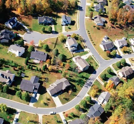
Historically, neighborhoods and communities have included a wide variety of home sizes and lot sizes. Small cottages were built on small lots. Large estate homes were built on larger lots. In older neighborhoods, these lot sizes and house types were seamlessly intermingled on the same block or from one block to the next.
However, with the advent of the post-WWII suburban zoning paradigm, entire tracts of land were zoned for one standard minimum lot size or width, making building those smaller cottages much more difficult. A common rule of thumb is that the home’s value will be approximate three times the value of the land it is on. With larger lots in high-demand areas, the land is too expensive to justify building only a small cottage. Instead, the larger the lot, the more expensive the land. The more expensive the land, the more expensive the home built there. In this way, larger lot sizes can be an exclusionary tactic used to prohibit smaller, less expensive homes.
Communities which intentionally zone land to require large lot sizes to discourage smaller, less expensive homes from being
built are leaving people behind. High housing prices can make living in certain communities nearly impossible for fire fighters, teachers, daycare workers, and other individuals the community relies upon. The practice of trying to keep out specific housing types is resulting in failed recruiting attempts to find a qualified workforce. Further, the Michigan Zoning Enabling Act (MZEA) prohibits the exclusion of uses and a 2015 Supreme Court ruling began to examine the concept of disparate impact where low-income individuals were excluded from better areas of a community.
HOW IT IS USED
Many communities use lot width or lot area (often the two in combination) to regulate the "character" of a neighborhood. These standards can be very blunt tools that, ironically, can be used to regulate and reinforce sameness.
More often, the standards that impact context have much more to do with how buildings frame the street: the proximity of trees to the road, how large those trees are, the amount and style of landscaping employed on both private property and within the public right of way, and the materials, architectural style, and form of the buildings. Lot width and area requirements in and of themselves do not necessarily give a neighborhood any sense of character. Yet, they are often relied upon as the sole or primary method for articulating development patterns.
PARADIGM SHIFT
While the cost of land is one of many factors that impacts the cost of housing in a particular neighborhood, allowing more homes is an excellent mechanism to turn the dial toward slightly more affordable housing.
For example, if a 10,000 sq. ft. lot sells for $75,000 and a builder/owner is permitted to build a single home on the lot, the total value of the land will be reflected in the sales price of the house – adding $75,000 to the total cost of construction. However, this land price can be reduced by one-half or one-third per new home constructed if an additional home or two is permitted to be built. In this example, lot width and lot area requirements can have a $25,000 to $50,000 impact on the price of a new home in the neighborhood.
If the 1,000 sq. ft. home above can be built at-cost for $200,000, the size and value of the land can potentially add anywhere from 12% to 40% to the final price tag. A 33’ x 100’ lot should be one option for a builder or homeowner to choose if a large yard is not a priority for the homeowner.
COST OF HOME + ~$75K COST OF HOME + ~$37K COST OF HOME + ~$25K

Image courtesy of Ryan Kilpatrick
Zoning Ordinance Case Study: Traverse City
This block in Traverse City includes lots that range from under 30’ to more than 200’ in width. Lot areas range from 2,000 sq ft up to ¾ of an acre. The average lot in this neighborhood is roughly 50’ x 170’ (8,500 sq ft). Yet, other lot sizes (both larger and smaller) coexist nicely. Also included in this image are the estimated values of each home and property. The size of the property is not always the primary indicator of the property’s value in this example, and there is a most noticeable correlation in the smaller lots, allowing for more moderately priced properties.
Ch. 1332 – R1a and R1b – Single-Family
• The Single-Family Dwelling—Large Lot (R1a) District is for the purpose of primarily accommodating conventional single-family dwellings. • The Single-Family Dwelling—Small Lot (R-1b) district is for the purpose of accommodating single-family dwellings on small lots. • Clustering (e.g., single-family attached, zero-lotline detached dwellings) may be allowed in either district on larger parcels within the designated density guidelines as a means to protect sensitive soils and provide usable open space. Reducing minimum lot width and area requirements can also have implications for infrastructure costs to a community. Allowing existing lots to be split for new homes takes advantage of existing infrastructure for infill development.

POSSIBLE OBSTACLES TO DESIGN AND IMPLEMENT
Many people believe the myth that sameness preserves property values. Opponents to allowing a diverse range of lot widths and sizes will argue that allowing for smaller lots will reduce their property value, add unwanted traffic, or change the neighborhood’s character. Research by land economists provide evidence that does not support these claims. Neighborhoods with a greater diversity of housing types and price points fared much better during the Great Recession than homogeneous neighborhoods with only single-family homes.73

Photo courtesy Modern Cottage Blog
TECHNICAL RESOURCES
• Your County may have a parcel viewer that you can use to view lot dimensions in your community, such as Kent County Parcel Viewer or Property Gateway in Oakland County. • BS&A is a great resource to view property values and other information.
Reduce or Eliminate Minimum Dwelling Unit Size
WHAT IT IS
Most communities have established a minimum dwelling unit size for various housing types. For example, single-family homes must be a minimum of 1,000 square feet, and multi-family units will have a minimum size that can range from 400 square feet to 800 square feet, depending on the community.

Master Plan Case Study: Eaton Rapids (2020)
Goal: Variety • Update the Zoning Ordinance to reduce the minimum lot size and/or minimum floor area requirements in residential neighborhoods. (p. 75)
Master Plan Case Study: River Rouge (2017)
Goal: Provide high-quality housing options throughout the City that meet the housing needs of all ages, income levels, and levels of disability. • Action: Reduce the minimum floor area for studios and one-bedroom units. (p. 90)
WHY IT IMPACTS HOUSING
The cost of a home is very often directly related to the size of the house. Size isn’t the only factor influencing cost, but it is a significant contributing influence. As a result, when a local community predetermines that all detached homes must be at least 1,000 square feet, the community makes choices on behalf of individual homeowners. From the single widow in their early 60s seeking to transition into a small cottage to the young professional hoping to move out of their parent’s house into their first apartment, minimum dwelling unit sizes often have unintended impacts on which housing choices and price points are available in a community.
HOW IT IS USED
Minimum dwelling unit sizes are often imposed to prevent certain kinds of perceived incompatibilities. In some instances, a minimum dwelling unit size for detached homes was a reaction against mobile homes. However, these standards often created hundreds of non-conforming structures among post-WWII homes that might range from 750 to 950 square feet. This was the workforce housing for the Greatest Generation, and in many communities across the state, it has become illegal to build.
To implement, consider reducing the minimum required dwelling unit size by housing type. Or, you could even eliminate a mini-
mum dwelling uit size. Some communities do not regulate the minimum dwelling unit size within their zoning ordinance. Instead, the zoning code defers to the standards of the Michigan Building Code. It is also common for Homeowner Associations (HOAs) to have their own private standards.
PARADIGM SHIFT
Since the 1970s, the average household size in the United States has been steadily falling. In 2020, just under 40% of all households in Michigan included children under 18 in the home. This means 60% of all households are comprised of a single adult or two adults without children at home.
Young professionals and empty nesters are both more likely to prioritize the location of their home over the size of the house. Communities that revisit minimum dwelling unit sizes can better accommodate the shifting demands toward lower maintenance and higher amenity options like cottage courtyards, townhomes, and condominiums. In high-growth markets with many young professionals seeking to live close to downtown, studio apartments are also an important option to allow. Combine this tool with Reduce Minimum Lot Area and Width Requirements or more flexible density standards, and this is a winner for creating housing that is more affordable.
Zoning Ordinance Case Study: Glen Arbor Township
Residence: A dwelling that is designed and built for human occupancy. The dwelling must have a minimum of 480 sq. ft. and a minimum core dimension of 20 feet by 20 feet (400 sq. ft.) The dwelling must have a bedroom, full bath, kitchen/ dining area, and a living room. A residence may be occupied full or part-time and is often referred to as a home, house, apartment, condominium, modular home, or mobile home.

Google Streetview
TECHNICAL RESOURCES
• The New Neighborhood, Empire, Michigan • Pocket Neighbohoods
POSSIBLE OBSTACLES TO DESIGN AND IMPLEMENT
This is a fairly simple code adjustment with very few obstacles in the way of enacting right away. However, it is common to hear neighbors or planning commissioners express concerns about allowing smaller homes to be constructed in a neighborhood. The perception is that a smaller home will be less expensive and this will cause a drag on property values in the neighborhood. In reality, most property valuations are based on a combination of factors which include location, condition of the home, size of the home, and proximity to positive or negative features in the community. Where smaller homes are permitted in neighborhoods with a diversity of housing types, the smaller homes tend to retain a property value that is higher on a per square foot basis than larger homes. This means that an 800 square foot cottage in a neighborhood with 1,600 and 2,400 square foot homes will likely be valued more per square foot than the larger homes.
• 800 square foot cottage: Estimated property value of $230,000, or $287/sq. ft. • 1,600 square foot home: Estimated property value of $325,000 or $203/sq. ft. • 2,400 square foot home: Estimated property value of $399,000 or $166/sq. ft.
Reduce or Eliminate Minimum Parking Requirements
WHAT IT IS
Most zoning ordinances require off-street parking to be provided for development. Commonly calculated by use, parking requirements are typically the minimum number of parking spaces that must be provided. Commercial uses may require parking based upon gross square footage or the number of employees, while residential uses commonly require parking based upon the number of dwelling units or bedrooms. Reducing or eliminating the minimum number of parking spaces required is an intervention that can lower the cost of development to make a housing project more feasible and/or increase the amount of developable land for more housing units.
Master Plan Case Study: Ann Arbor – Comprehensive Transportation Plan (2021)
The city should expand its current policy for downtown and remove minimum parking requirements from the Unified Development Code so that all new developments can determine the proper amount of parking based on existing and forecasted demand. A variety of cities across North America, including Buffalo, New York; Hartford, Connecticut; and Edmonton, Alberta have all eliminated parking minimums.
A. In addition to removing minimum parking requirements, Ann Arbor should establish maximum parking ratios in downtown and other locations well-served by transit, such as along signature transit corridors (see Strategy 10). Maximum parking ratios set a ceiling for how much parking a development can include, while giving developers the option to provide any amount of parking beneath that threshold. B. By removing parking minimums citywide and establishing parking maximums in appropriate locations, the supply of parking will be better aligned with real-world demand. Requiring less land to be set aside for parking can bring a multitude of benefits by increasing housing affordability and freeing up land for alternative uses. (p. 106)
WHY IT IMPACTS HOUSING
Providing off-street parking costs money. That cost can be for the additional land area required to construct parking, the cost of materials to construct a surface parking lot or parking structure, or the cost of adding a garage to a residential structure. The cost of building surface parking spaces generally starts at $20,000 for each space. A spot in a parking structure costs about $45,000, and underground parking can cost upwards of $75,000 a space. This cost is passed to the occupant, resulting in higher housing costs whether or not that person owns a vehicle. The cost of providing parking also limits the ability of a developer to provide more housing units. Land or square footage that could be devoted to residential dwellings is relegated to parking. A study by the Mortgage Bankers Association found parking spaces outnumber homes 27:1 in Jackson, Wyoming. Philadelphia's parking density is 3.7 times greater than that of homes, and Des Moines has 83,141 households and 1.6 million parking spaces.74
The relationship between parking, land use, and transportation can become a vicious cycle. Parking minimums drive up housing
costs, which inadvertently locates more affordable housing in areas where land is cheaper. In these "more affordable" areas, however, the need to drive and park is prevalent and raises household expenses for vehicle ownership.75 In this way, parking minimums contribute to sprawl and support the need for an automobile as the only reliable or realistic form of mobility, thereby reducing access to jobs, education, medical assistance, recreation, and nearly all other amenities and opportunities. This decreased accessibility most severely impacts people without the means to own an automobile or who cannot drive.
Zoning Ordinance Case Study: Traverse City
Traverse City outlines a vision for transportation that balances the use of the personal auotomobile with pedestrians, bicyclists, and other modes.
Chapter 1374 – Circulation and Parking “The purpose of chapter is: • To make Traverse City safe and accessible by pedestrians, cyclists, drivers and passengers.
• To give equal consideration to the pedestrian in the design of all public and private parking areas.
• To promote site designs that help to reduce crashes and conflicts between pedestrians and vehicles.
• To maintain the utility of the public rights-of-way to move goods and people safely and adequately.
• To promote interesting street edges that invite people to walk.
• To encourage a healthier transportation mix.” Traverse City also reduced their residential parking requirement from 1 per dwelling unit to zero.

Progressive AE
HOW IT IS USED
Parking requirements can be structured in a variety of ways. For residential development, a minimum number of spaces may be required per dwelling unit, the number of bedrooms, or the type of occupant (for example, senior living). Parking requirements can be reduced by decreasing the number of parking spaces required per dwelling unit. Instead of 2 spaces per dwelling unit, many communities now require 1 or 1.25 spaces. You can also establish different thresholds based on the number of bedrooms. For example, all dwelling units with two bedrooms or less could be required to have only 1 parking space, but 0.5 additional parking spaces could be required for each additional bedroom.
Proximity to transit or a community’s central business district or the availability of bike infrastructure and public parking can also influence parking requirements. Many communities do not require parking in business districts, either for all uses or for non-residential uses. Other cities waive parking or reduce parking for housing located within a certain distance from a transit stop, such as half a mile or 500 feet. Another strategy is to waive a certain number of parking spaces if there is available on-street parking within a certain radius. Car parking requirements could also be reduced if bike parking is provided.
Additionally, allowing for shared parking agreements for complementary uses can be a way to limit the amount of off-street parking for neighboring parcels. Uses with a primary parking need during the day can allocate their parking spaces to uses with a primary parking need during the evening or vice versa.

Instituting maximum parking requirements is another way to limit parking provision and signals an attitude shift. A development providing more than a certain percentage above the minimum parking requirement may be required to receive special land use approval for the excess parking. Lastly, some communities are exploring eliminating parking requirements altogether. Developers are allowed to decide the parking the amount of parking needed.
PARADIGM SHIFT
It is not the responsibility of the local government to guarantee free and convenient parking for every resident, visitor, and business owner. Many communities established parking minimums in the 1950s and 1960s when developable land was more plentiful and attitudes about the automobile were different than they are today. However, the unintended consequences of prevalent parking are coming to bear. Local government units are questioning the utility of parking as a land use compared to other more productive uses. A report by the Urban Land Institute found that “parking often earns only 7 to 42 percent of the tax revenues earned by other land uses.”76
Sustainability and quality of life concerns are other motivations for reducing parking minimums. Required parking can lead to increased traffic congestion and pollution, increased flooding and property damage from impervious surfaces, and rising temperatures due to the heat island effect.
Communities across the country are beginning to rethink their parking policy. A study by Parking Reform Network of 200 zoning ordinances across the country found that 20% have eliminated or reduced parking minimums throughout their entire jurisdiction.77 The reality is that parking minimums are generally unncessary in the zoning ordinance. Developers and the banks underwriting their financing will generally consider parking within the overall marketability of the development. It is in their best interest to finance/build only enough parking to meet end-user needs, or else it won't be marketable. There are two scenarios that result: either the ordinance requires more parking than the use actually requires, pushing up costs for parking that never gets used, or else the ordinance requires not enough parking and the developer will build more than the ordinance minimum, making a minimum requirement irrelevant.
POSSIBLE OBSTACLES TO DESIGN AND IMPLEMENT
Residents may say, "If you don’t require parking for X development, people are just going to park in my neighborhood." Depending on the location of the neighborhood, it is possible this could happen. Solutions like on-street permit parking can be explored as well as parking management districts. Remember that oftentimes that same neighborhood is desirable is because of the nearby amenities. Reduced parking should be done in tandem with policies to encourage transit and nonmotorized transportation. This could entail changing the conversation around “free” parking and “free” roads. These are being paid for, but the costs may feel less direct.
TECHNICAL RESOURCES
• Local Housing Solutions – Reduced Parking Requirements • Parking Reform Network • Urban Land Institute – Parking Policy Innovations in the United States
Missing Middle Housing (including ADUs)
WHAT IT IS
Missing middle housing types take many shapes and sizes. Typically, “missing middle” housing refers to the moderate density housing types between detached single-family and larger multi-family housing. Commonly 2-20 units per structure. The Opticos graphic below illustrates these housing types. The following is a shortlist of missing middle housing types..
Accessory dwelling units (ADU), sometimes referred to as a granny flat, in-law suite, or guest house, is a more commonly known example of missing middle housing. An ADU is a small residence that shares a lot or building footprint with a larger primary dwelling. These types of dwellings can offer tremendous flexibility for the homeowner – a place for an aging parent who would like to remain semi-independent but needs someone to look in on them regularly; an adult child saving for the down-payment to purchase their own home; a family friend who has recently gone through a divorce; or a working professional who has relocated to the area for a job but would like to take time to get to know the community before buying a home. Sometimes the homeowner will live in the accessory dwelling and rent the primary home to a family.

Photo courtesy of City of Tucson, AZ

Townhomes or attached single-family
homes are typically houses attached to the neighboring house via a shared wall. These house types can be built on smaller lots with a smaller building footprint while still allowing for single-family homeownership with a traditional mortgage. This is one of the best ways to provide housing that can be family-oriented, owner-occupied, and remain relatively affordable.
Small Apartment House or Mansion
House is an excellent way to integrate a different housing type into a neighborhood while maintaining some consistency with existing homes. These building types can fit seamlessly onto lots that are very similar in size to a detached house but can accommodate 3-6 apartment units. These building types create housing choices within neighborhoods that might otherwise be inaccessible to local residents, offering stable housing for essential workers, young professionals, and older residents who would like to age-in-place and no longer want the upkeep of their bigger home.

Photo courtesy Mosaic Homes

Photo courtesy Metric Structures
WHY IT IMPACTS HOUSING
Missing Middle Housing offers opportunities to build more than a single home on a traditionally sized lot in almost any neighborhood type. The building design and character should be very similar in size and massing to other structures in the neighborhood – see the Form and Site Standards tool for more detail on how to shape these regulations. By allowing these building types, local neighborhoods can offer housing choices in a broader range of sizes and price points while providing better access to local schools, parks, and amenities.
HOW IT IS USED
Missing middle housing is often located near neighborhood entrances, commercial districts, community gathering places like parks or recreation centers, between planned commercial/retail nodes, or on corner lots. Small clusters of missing middle housing can offer much needed diversity of housing types while maintaining the traditional character of a neighborhood.

Photo courtesy Thomson Architecture
PARADIGM SHIFT
Missing middle housing meets the needs of a range of household types. The following are a few reasons why a diversity of housing types is becoming more popular and necessary in the U.S.:
Master Plan Case Study: Cassopolis (2019)
GOAL #7: Identify residential growth opportunities and within five years, develop a strategy to attract housing types that match the State of Michigan’s definition of ‘missing middle housing’, including: townhouses, mansion flats, fourplexes, duplexes, live/work, etc. OBJECTIVE A Execute a Residential ‘Target Market Analysis’ (TMA) to determine gaps in needs and attract developers (in conjunction with the commercial TMA). OBJECTIVE B Identify appropriate locations for missing middle, multifamily, and single-family residential types and identify strategies to attract residential developers. OBJECTIVE C Rezone land as needed to develop a comprehensive plan for the future of housing and the amenities that will be supported, and in turn support, new residents. (p. 43-45) • Aging in place. A large segment of the population in many communities is aging and ready to let go of home maintenance responsibilities but would prefer to remain in an active and familiar neighborhood.
Offering smaller cottages, townhomes, attached homes, condominiums, and accessory dwelling units can be an excellent way to support older adults who want to remain in their neighborhood without being obligated to own a 3,000 sq. ft. house with a large yard and all of the responsibilities that come along with it.

• Multi-generational households. Missing middle choices allow for families to care for elderly relatives or launch young adults into more independent living while keeping a close eye on them. Missing middle housing allows multi-generational families to maintain privacy and independence.
• Housing across the lifecycle. In some life stages, smaller homes are the most suitable. First-time home buyers often can’t afford the largest homes, and elderly homeowners often want to downsize to something smaller and with less maintenance.
• Financial benefit. A homeowner can generate additional income by renting out one of two units in a duplex or an accessory dwelling on their property. A homeowner can also opt to live in the ADU and rent out the primary structure.
POSSIBLE OBSTACLES TO DESIGN AND IMPLEMENT
Some of the missing middle housing types are more likely to be rentals. Many people perceive renters as a potential threat to neighborhood stability. However, more than two decades of research have shown that neighborhoods with a diversity of housing types tend to fare better during economic downturns and have an equal or better rate of property value appreciation than their single-family only counterparts.

New construction is always surprisingly expensive, even for smaller and more diverse housing types. Neighbors may complain that proposed missing middle housing types are not affordable enough to justify the transition from single-family only. However, these arguments rarely consider the even higher cost of building new singlefamily homes as a comparison. Missing middle housing types will require adequate water and sanitary services. This may mean a more extensive shared septic system or available underground utilities. However, smaller housing units typically accommodate smaller families who impose a lesser burden on infrastructure than larger families. Systems should be sized for the number of bathrooms and kitchens being served rather than the number of units.
Zoning Ordinance Case Study: Brighton
Article 98-3.0 Zoning Districts, R-5 Uptown Multiple Family
The R-5 multiple-family residential medium-to-high density district is intended to provide for residential units in a variety of styles and types within walking distance (five– to ten-minute walk) of downtown and adjacent to the downtown business district. The R-5 district is a unique area of the city. It is located north of downtown, east and west of N. Second Street, and is primarily surrounded by industrial and commercial uses. A portion of the district fronts on the Millpond. It is intended to be transitional between areas of dissimilar land use and the downtown. It also is intended to implement the High Density Mixed Residential category on the City’s Future Land Use Map.
This district is divided into two sub-districts: Uptown North and Uptown South. Uptown North is envisioned with larger-scale multiple-family development projects on larger lots. Typical building types include large apartment buildings and townhouses. Uptown South is envisioned with small-scale, multiple-family structures on smaller lots, including redeveloping one or two lots of record that meet the dimensional requirments for the desired building type. Typical building types include townhouses, courtyard apartments, fourplexes, and similar types.
• For Uptown South, a typical building of one to three stories is envisioned. For Uptown North, up to four stories may be permitted if certain standards are met and the development is compatible with the surrounding neighborhood. The neighborhood in the R-5 district should be walkable, and tree-lined streets should encourage pedestrian linkages to downtown.
TECHNICAL RESOURCES
• AARP ‒ The ABCs of ADUs • AARP ‒ Home and Community Preferences Survey • Local Housing Solutions ‒ Missing Middle • HousingMissingMiddleHousing.com • MEDC ‒ Missing Middle Housing Solutions
APPLICABLE CASE STUDIES
• Celadon New Town, Grand Rapids Township • Veridian at County Farm, Ann Arbor • North Barton Mews, New Buffalo
Density / Height Bonuses
WHAT IT IS
Many communities regulate development based on the number of dwelling units per acre, number of stories per building, or building height. Each of these regulations creates an artificial cap on the number of homes or apartments that can be developed on a given parcel of land, regardless of what pressure there may be on the private market to produce more housing on the site. Creating a density bonus or a height bonus gives the planning commission and/or local governing body the ability to allow the private market to build more housing on a given site if the developer agrees to provide something associated with the project that also aligns with community priorities. A density bonus may be related to affordable or attainable housing, greenspace or open space preservation, sustainable development, or another priority that has been established by the community.

Master Plan Case Study: East Lansing Master Plan (2018)
Future Land Use Category: Residential 3 – Context: Zoning Plan This land use category is shown on the future land use map primarily where there is a mix of renter-occupied housing and owner-occupied housing within a single-family residential neighborhood or where there are multiplex building types three (3) stories or less on the edge of a single-family neighborhood. The category allows for rowhouse and small multi-plex building types. It is limited to these building types at a density of sixteen (16) units per acre with heights no higher than two and one half (2.5) stories or thirty-five (35) feet by right or four (4) stories or fifty (50) feet with a bonus. The intent of this land use category is to increase the variety of housing choices with a small-to-medium building footprint by allowing a higher density than the Residential 2 Category through increased height as a bonus and where it provides a transition between residential and commercial uses and between higher intensity multiple-family uses and single-family residential uses through the redevelopment of existing building types. (p. 88)
WHY IT IMPACTS HOUSING
Artificial constraints on the creation of new housing supply tend to impose a mismatch between supply and demand. When the local housing market proves a demand for more housing units per acre than the local zoning will allow, this typically creates scarcity in the market and pushes prices up more quickly.
HOW IT IS USED
By creating a density and/or height bonus, the community can allow for an incremental increase in housing units while simultaneously negotiating for community priorities that align with the project. However, it is imperative that this tool be calibrated to the local economic conditions in the specific neighborhood where it is
being utilized, and that the local planning commission has a clear understanding of the true cost of implementing the community’s expectations. In some neighborhoods, a single story of additional height, or a half dozen additional dwelling units per acre can make an important difference for financing. In other neighborhoods, multiple stories of additional height or a doubling of density will be necessary to make the provision of the community amenity make financial sense.
Cost-benefit analysis example: Mixed-Use building A mixed-use, three-story building with a 10,000 sq. ft. footprint costs roughly $7,000,000 to construct on a half-acre lot. The proposed building will have 5,000 sq. ft. of ground floor retail/commercial space and 28 residential apartments. In order for this development to make financial sense for an investor, the developer must charge at least $18 - $22 per square foot for the commercial space and an average of $1,300 per month for the apartments. This rental rate is roughly affordable for households who are earning at least $52,000 per year in the local community.
If the community offers the developer the option to build a fourth story in this building and add another 10 units to the project, it is possible for the developer to moderately reduce the rent for a portion of the additional apartment units. It is important to recognize that the additional apartment units will each bring additional costs to the project. However, the overall cost per unit to construct these additional apartments will likely be slightly less as the number of units increases.
While the overall cost of construction will increase with every apartment unit added to the project, the cost of land, design fees, legal fees, and much of the site work will remain relatively the same whether the building is three stories or four. This means that at least 3-5 of the additional 10 apartment units could be leased for $900 - $1,000 per month instead of $1,300 per month. These additional units would be attainable to households earning at least $36,000 per year and works out to roughly 10% of the total units in the project being income-restricted and affordable.
Cost-benefit analysis example: New neighborhood subdivision Similar to the previous example, communities can negotiate for an increase in the total number of homes per acre within new subdivisions. Where an underlying zoning code may permit 3-6 units per acre, allowing for 9-12 units per acre (or more) can provide for significant cost reductions on a portion of

Photo courtesy City of San Francisco Photo courtesy Matt Reames

the homes. The greater the density bonus, the greater the likelihood of a reduction in price.
Once again, in the example involving homes for sale, there are some fixed costs associated with construction that cannot be eliminated or reduced with a density bonus. However, by allowing for a greater number of small lots, and by allowing some of the homes to be attached instead of detached, a developer is able to disperse the cost of land, legal fees, design fees, and site work across a greater number of units. If negotiated strategically, this is an excellent opportunity to support mixed-income neighborhoods with a variety of housing types and price points to support a variety of family sizes and income levels. See Missing Middle Housing to learn more about these housing types.
PARADIGM SHIFT
For decades, many communities have operated under the assumption that density was not good for property values, tax revenue, neighborhood stabilization, and a host of other community priorities. In fact, the Michigan Zoning Enabling Act even cites one of its purposes being to “limit the inappropriate crowding of land and congestion of population!”78 However, density carefully designed and regulated can offer dramatically improved property values, greater tax revenue relative to services required, and neighborhoods that are much more vibrant and socially connected.
Moreover, the National Association of Realtors biennial poll (2019) finds that a majority of homebuyers or would-be homebuyers prefer a walkable, amenity rich neighborhood to a large lot subdivision. The poll also found that a majority of Millennials, the Silent Generation, and the Greatest Generation preferred a smaller home in a walkable neighborhood to a large home without walkable amenities. These preferences have been consistent for about a decade. (It should also be noted that while the COVID-19 pandemic has impacted preferences for walkability, it is too soon to say whether these attitude shifts are permanent.)
The adjacent image illustrates two different neighborhood plans on the same ~18acre parcel. The design at the top creates space for 38 new single-family homes. In Michigan, these homes will likely be priced from $325,000 to $425,000 each or more, depending on the location. Total investment is likely around $12.5 million and taxable value is roughly $6 - $7 million. The design at bottom creates space for 146 new dwelling units (40 single-family homes, 16 studio apartments, 16 live/ work dwellings, and 74 townhouses), along with more than 50,000 square feet of commercial/retail/restaurant space, and a 10,000 sq. ft. church. Prices in this neighborhood are likely to range from about $1,000 per month or less for the studio apartments, $225,000 to purchase a townhouse, and the same $325,000 to $425,000 price point for single family dwellings. In this design, total investment is likely to approach $50 million with a taxable value near $25 million – 3 to 4 times the
Comparative densities

revenue generated by the lower density option at top. Meanwhile, the mixed-density option creates housing choices for young renters, first-time homebuyers, emptynesters, start-up business opportunities, middle-income families, and folks who want a larger home with all the benefits of a walkable, amenity-rich neighborhood.
This is an example of a significant increase in density which can create a correspondingly large amount of attainable and even affordable housing within the neighborhood. In exchange for the additional density, the local community may require a deed restriction to preserve affordability on a portion of the additional homes permitted and permanent protection of the open space.
POSSIBLE OBSTACLES TO DESIGN AND IMPLEMENT
In many communities, density is still a four letter word. It may take some effort to communicate the benefits of allowing for greater densities. Creating a local capital improvement plan and clearly communicating the long-term obligation of local infrastructure can be a good opportunity to talk about density. The more efficient a community can be at maximizing the value of infrastructure to generate revenue that pays for short-term repairs and long-term maintenance, the lower the local tax levy must be to cover those costs. This, in turn, gives local voters choices to either reduce taxes or pay for additional amenities like public education, community recreation centers, enhanced parks, and open spaces, or even affordable housing. When granting a density bonus, it can be tempting for a local planning commission to continue to maintain the standard minimum requirements related to parking
Zoning Ordinance Case Study: East Lansing Article VI. Business, Office, and Industrial
Districts – Division 4. – City Center Commercial District, B-3 – Section. 50-593. Development Standards F. The minimum building height shall be four stories.
The maximum number of stories permitted is eight and the maximum building height is 112 feet. The city council may, upon an affirmative vote of three-fourths of all members of the city council, permit an increase in stories or a maximum building height of up to 140 feet for a building deemed by the city council to be of significant public benefit subject to an approved special use permit as provided in article II, division 3 of this chapter. Further, additional stories may be added to existing one- and two-story buildings that total less than four stories or 64 feet in height if the existing building remains substantially the same and no additional structural changes are needed to the existing building to support the additional stories.

and greenspace. However, these standards can often directly undermine the value of the density bonus. Each market is somewhat unique, but the higher the underlying land value, the more likely it is that excessive parking and open space requirements will undercut options for affordability.
TECHNICAL RESOURCES
• Inclusionary Housing ‒ Density Bonuses • Local Housing Solutions ‒ Density Bonuses • Inclusionary Housing ‒ Mechanisms for Preserving Affordability • Local Housing Solutions ‒ Deed-Restricted Homeownership • Randall Arednt - Rural by Design: Planning for Town
Form and Site Standards
WHAT IT IS
Form- and site-based standards regulate the form and placement of a structure on a parcel. These standards are a middle ground between a conventional use-based zoning code and a form-based code. While a form-based code in the strict sense of the term is agnostic towards the use of a building, form and site standards work to appropriately integrate specific uses into an area. Use still matters, but a neighborhood can host a wider variety of them so long as they are appropriately sited and integrated.
Master Plan Case Study: Lansing – Design Lansing Comprehensive Plan (2012)
The City of Lansing established a Form Based Code in 2021 based upon recommendations from its 2012 master plan to adapt zoning standards to preserve and encourage appropriate neighborhood patterns. Ch. 7 – Placemaking. Transect and Pattern Types “A transect is an urban-to-rural cross section that identifies the relationship of pattern types which vary in the intensity and character of their natural and built components across the city. The different pattern types are defined by the design elements described above, including the layout and design character of streets; lot sizes and how buildings are located in relationship to the street and each other; building types and architectural styles and features. The transect and pattern type descriptions are often compiled in a “pattern book” and used to encourage building and neighborhood design decisions that reflect the regional location and architectural history of a city and that, as a result, are more compatible with the valued characteristics of the existing built context. They have been used effectively to counteract the standardized, “anyplace” design of mass-producedhousing and chain retail buildings and to ensure a coherent character and consistent quality in large development projects implemented over time by a variety of builders. By understanding the pattern types and relationships that exist today, Lansing will establish a basis for developing the tools needed to ensure that valued patterns are preserved and less desirable patterns are enhanced or transformed in the future. This information provides the basis for future discussions on how placemaking content – also known as urban design or form-based considerations – might be made part of Lansing’s development regulations and/or review and approval process.” (p. 162).

Photo courtesy Brookfield Neighborhood
WHY IT IMPACTS HOUSING
If a common argument against range of housing types is that they don’t “fit in” to the existing neighborhood, form- and site-based development standards can help integrate denser housing into a low or mixed density neighborhood development pattern. These standards help to quantify the term “neighborhood character,” which can often be an amorphous flag waived in opposition to new or more dense housing projects. Form and site regulations allow for the harmonious integration of townhouses, accessory dwelling units, duplexes, and small apartment buildings into residential or commercial zone districts. More units in more places means an increase in housing supply. Rather than barring certain housing types from a zone district outright, they allow for the location of these different types strategically.
HOW IT IS USED
The standards here fall into two categories: those that address the siting of a particular housing type within a neighborhood or on a parcel and those that address elements of the building’s form. These standards can be based upon a variety of factors: the zone district, the location within a street network, the size or frontage of the parcel, or the use, for example. While you are no doubt familiar with the dimensional or site layout standards common to a zoning ordinance such as minimum lot area or minimum front yard setback, this tool attempts to prioritize the form or context of a structure more than the number of housing units (density) itself when determining its appropriateness for a site.
Site and context regulations can allow a duplex or a multi-family dwelling to be permitted by right when certain lot criteria are met. For example, a duplex can be allowed by right when located on a corner lot, or perhaps an apartment building is permitted by right on all major streets within a community, regardless of the zone district. If you opt for that strategy, make sure to classify all the streets in your network and produce a map to refer to.
Building element requirements can ensure that higher density development integrates with the rest of the neighborhood context. These standards can apply to things like façade variation, building orientation, transitional features, and transparency. In older neighborhoods, you might regulate the front entrances of buildings, making sure that traditional features like a porch or the framing of the doorway are maintained. In this way, Missing Middle Housing can appear architecturally similar to singlefamily homes. Form-based standards produce buildings that feel consistent in scale and massing and their relationship to the street and other buildings. This can result in a neighborhood that includes more than just detached single-family structures because structures are complimentary.
Consider form or context elements that the community may regulate: building orientation and placement, parking location, expression line, transparency, building materials, entrances and porches, landscape buffers, and building stepbacks. There will be a tension here, however, with costs and feasibility to be mindful of.
Form and site standards when used in conjunction with other tools like Expand Allowable Uses and Rezone for MixedUse/Multi-Family in Commercial Districts, allow us to create the sorts of unique neighborhoods that are beloved and typically could not be built under the conventional zoning codes that became ubiquitous in the early to mid-20th century. As an added benefit, many of these form and site standards can work to create more pedestrian-friendly and safe neighborhoods.

Zoning Ordinance Case Study: Pittsfield Township
Pittsfield Township created five mixed-use form-based districts in their most recent comprehensive zoning ordinance update. These districts were created in order to align with the 2010 Master Plan’s vision for six mixed-use development nodes throughout the township. Each site in these districts has a street type, site type, building form, and use group.
Article V. Form-Based Mixed-Use Districts / 40-5.01 General intent, purpose, and use.
Intent. The Master Plan identified focus development areas within the Township that place greater emphasis on regulating urban form and character of development as well as use and intensity of use. Within these focus areas the Township encourages development with a mix of uses, including public open space, in order to provide transit-oriented development in a sustainable way. The Form-Based Mixed-Use Districts are intended to implement the vision, goals, and objectives of the Master Plan and any other applicable plans.
Purpose. The general purposes of these regulations are to: • Ensure that development is of human scale, primarily pedestrianoriented, and designed to create attractive streetscapes and nonmotorized spaces. • Promote infill development and redevelopment. • Promote a compact growth pattern to efficiently use the remaining developable land, and to enable the cost-effective extension of utilities, services, streets, and transit service. • Promote mixed-use development in both a horizontal and vertical form. • Ensure reasonable transition between higher-intensity development and adjacent neighborhoods. • Improve mobility options and reduce the need for on-site parking by encouraging alternative means of transportation.
Factors for regulation. These regulations are based on two significant factors: site context and building form. Site context is derived from existing and desired characteristics, which include street types and site types. Streets can be divided into various types, based on purpose and unique attributes. Sites are divided into types based on characteristics including shape, size, and orientation. Areas are distinguished from one another by their site context, which includes size and configuration of the site, street patterns, location, existing land uses, and intensity of use. Therefore, considering site context provides a customized approach to the inherent conditions of the areas where these regulations are applied
Building form addresses the manner in which buildings and structures relate to their lots, surrounding buildings, and street frontage. The shape of the building, the land area to volume ratio, and the orientation of the building have significant impacts upon the general feel and character of an area. Building form standards control height, placement, building configuration, parking location, and ground story activation applicable to the site context
Regulations are tailored to meet a more specific intent of each district. These districts and intents are set forth elsewhere in this article.

TECHNICAL RESOURCES
• Form-Based Code Institute • Congress for New Urbanism • CNU & MML – Enabling Better Places: Users’ Guide to Zoning Reform • CNU & AARP – Enabling Better Places: A Handbook for Improved Neighborhoods • City of Minneapolis – Minneapolis 2040: Land Use and Built Form

Diagram courtesy Progressive AE
PARADIGM SHIFT
One large shift is defining the various housing types as residential uses. While this might seem like a "duh" comment, standard zoning ordinances regard different housing types as completely different uses. For example, "multi-family" is a listed use, as are "duplexes" and "detached single-family". They are, in fact, all residential uses. The actual differentiator between them is the number of dwelling units contained within the structure.
It may also seem like an abrupt change to step outside outside the paradigm of the zoning district determining the appropriateness of the number of dwelling units. But form and site standards exist even in the most conventional of zone districts today. It is common for a development to be possible only if setbacks are met, for example, or a lot being able to be divided only if the resultant parcels are larger than the average of the surrounding lots. It is not that these form and site regulations are more onerous than the ones you might be familiar with, they simply have different objectives. Instead of taking the stance of exclusion, these standards are aimed at inclusion: expanding residential housing choices within a given neighborhood or district. And by expanding allowable housing types, you are also expanding options for the people that make up your community.
POSSIBLE OBSTACLES TO DESIGN AND IMPLEMENT
Form and site standards may feel onerous at first but, if combined with a consolidation of zoning districts and an expansion of allowable housing types, you may end up with a zoning ordinance that is easier to administer. You will be able to determine the appropriateness of a housing type based on whether certain form or lot characteristics are met. As stated previously in the Collapse Residential Zone Districts and Expand Allowable Uses tools, form and site based standards will require an understanding of the existing and desired development patterns at a detailed level. You’ll want to understand what unifies a residential neighborhood beyond simply the use. Are there trends in building heights and entrances? The relationship between buildings or between buildings and the street? Building element details?
Remember, you don’t have to scrap your current zoning ordinance and replace it with a form-based code. Communities across Michigan and the country have been able to implement form and site based standards incrementally. You could start with one district, perhaps in a commercial area. As residents and developers get used to formbased standards, you can choose to expand them.