4 minute read
THE PUBLIC’S RADIO: High tide


High Tide
Flooding o ers a glimpse of Rhode Island’s future as sea level rises
By Sofie Rudin
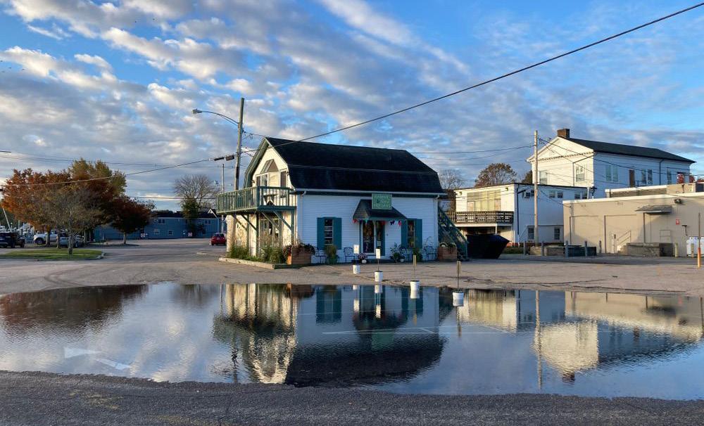
As the tide rolled in on a recent morning in Wickford, the center of the Brown Street parking lot gradually filled with water.
The parking lot is wedged between the harbor and the main street, which is lined by antique shops, boutiques, and restaurants. In the middle of the lot, water welled up through a storm drain.
“There’s a connection of the storm drain out to Wickford Harbor,” explained Teresa Crean, a coastal community planner with the University of Rhode Island who focuses on sea level rise. “So when the tides are really high, the water comes up from underneath and floods the area around the storm drain.”
The tide on this day was especially high for a couple reasons. The moon had been new recently, meaning it lined up with the sun, increasing the gravitational pull on the earth’s oceans. And the moon was at its closest point to the earth in its monthly orbit, which also strengthens its pull. These extra-high tides are known as king tides or spring tides.
King tides regularly cause flooding across the state: from Atlantic Ave in Westerly to the Oakland Beach neighborhood in Warwick, from Waterplace Park in Providence down through the East Bay.
As global warming causes sea level to rise, high tide flooding like this is becoming more common. In 2000, tide stations in Providence and Newport recorded two to three flooding days per year. By 2050, the National Oceanic and Atmospheric Administration projects those cities could see high tide flooding more than a hundred days each year.
The flooded parking lot in Wickford “represents what we are going to expect on a daily basis, you know, possibly 10 or 20 years from now,” Crean said.
She regularly visits this spot during storms and high tides to photograph the flooding.
“We’ve seen fish swimming. I always look for fish to see if any fish made it in,” she said.
On this morning, bicyclists and dog walkers detoured around the expanding pond, and a couple people hopped out of cars to take a look. The flooding crested about a dozen feet from a small building that houses the Harbor View Artisans co-op, which sells art made by 25 local artists.
“It happens quite often, like probably every
The parking lot outside Harbor View Artisans often floods during king tides.


couple of weeks,” said co-founder Neringa Aiello. She said the building flooded during Hurricane Sandy in 2012, but hasn’t since.
“When we opened up the store in April, everybody was like, ‘Oh, what are you thinking? You know, the parking lot floods all the time. And the building floods all the time.’ So we were like, ‘Holy moly, what did we get into?’” Aiello said. “But it seems like it stays dry in here and just the parking lot floods up. So we’re used to it. It doesn’t scare us anymore.”
Is she concerned about sea level rise?
“Yes, of course,” Aiello said, but she said it hasn’t yet factored into business decisions. “You know, hopefully – we don’t know how many years we’re gonna be here.”
The repeated floods have damaged the parking lot. The town of North Kingstown is working on plans for repairs that are aimed at reducing future flooding, funded in part by grants from the Rhode Island Commerce Corporation and Department of Environmental Management.
Those plans include building a taller wall around the lot’s outer edge and raising the level of the parking lot, particularly in the low dip where the storm drain sits. And the town will A map of Wickford showing areas at risk of flooding during high tides

install a one-way flap on the storm drain to keep the water from welling up during high tides.
“As sea level rises, this is going to become more and more common,” said Becky Lamond, one of the town planners. “But this isn’t the only low spot. We have trouble in several spots in Wickford, and evacuation routes can become inundated.”
An assessment by the town found just a couple feet of sea level rise could cut o road access to the Wickford neighborhood and flood several hundred properties throughout North Kingstown.
At high tide, the water also laps against the Wickford Bridge, which is part of a state road and one of the state’s most vulnerable bridges to sea level rise, according to a 2015 assessment.
The state Department of Transportation is planning repairs, which could include elevating the bridge. But work wouldn’t begin until 2030. By that point, scientists expect sea level in Rhode Island to have risen by more than a foot.
Reporter Sofie Rudin can be reached at srudin@thepublicsradio.org.
FAMOUS BRAND NAME CLOTHING
Fraction of the Regular Price!
1175 Boston Neck Road, Narragansett 782-1110 • Wed-Sun 10am-5pm


