S WE ENTER OUR FALL SEASON here in the High Desert, the days get shorter (daylight) and the temperature drops. We enter my favorite time of the year; Halloween-Thanksgiving-Christmas and for me Santa gigs.
For those that know me as Santa know that once I put on that outfit, I become SANTA. The smiles we see when our Santa TEAM shows up, from young and old boys & girls, makes what we do very rewarding. We will once again this season do our part in keeping the spirit of Christmas alive, but remember the reason for the season is not just Santa.
Santa getting a haircut and beard trim before the Christmas seaon. If you want to book Santa contact the North Pole via the PULSE.
Please join us in THANKING all the people, agencies, fire departments and citizens for their awesome work in protecting our communities from all the recent fires. GREAT JOB.
Remember to support our advertisers and the many events taking place in our areas.
Jim Conkle
The Impact of Poor Sleep A Deeper Explanation into What It Does to Us
by Melissa Mischka, PsyD
IHAVE REALIZED A CONSISTEN t trend among our clients and patients lately and it further highlighted the importance of proper sleep hygiene and the lack of knowledge that most people have about it. I have always had issues with healthy sleep and have tried countless techniques over the years but developing proper and consistent sleep hygiene has at least helped me to identify what works and what doesn’t. We all know that sleep plays a critical role in physical and mental well-being, serving as a foundation for emotional regulation, cognitive function, and overall health. However, with increasing demands from work, technology, and daily stressors, maintaining good sleep hygiene can often fall by the wayside. Poor sleep hygiene— marked by inconsistent sleep schedules, disruptive environments, and unhealthy pre-sleep habits—has a profound impact on mental health. Understanding how poor sleep habits affect psychological well-being is crucial for promoting healthier lifestyles and enhancing overall mental resilience.
One of the most immediate psychological effects of poor sleep hygiene is mood instability. Sleep deprivation disrupts the brain’s ability to regulate emotions, leading to increased irritability, mood swings, and emotional sensitivity. The amygdala, a key brain structure involved in emotional responses, becomes overactive in sleepdeprived individuals, making them more prone to emotional outbursts.
Over time, chronic sleep deprivation has been linked to more severe mood disorders, such as depression and anxiety. Studies show that individuals with insomnia are ten times more likely to develop depression and seventeen times more likely to struggle with anxiety disorders. Poor sleep exacerbates feelings of hopelessness, worry, and restlessness, creating a vicious cycle where the inability to sleep intensifies symptoms of mental illness, and mental illness further disrupts sleep patterns.
Cognitive function is another area heavily influenced by sleep. Poor sleep hygiene diminishes concentration, memory, and decision-making abilities. The brain relies on the deep sleep stages—particularly REM (rapid eye movement) sleep—
to consolidate memories and process information. When sleep is disrupted or cut short, the brain struggles to retain new information and make connections between ideas.
For individuals who suffer from chronic sleep deprivation, this cognitive impairment can become more pronounced over time. Lack of sleep leads to poor attention span, difficulty in focusing, and increased mistakes in both personal and professional settings. It can also reduce problem-solving abilities and make it harder to think creatively. This cognitive fog can impair academic performance, work productivity, and even everyday decision-making, leading to frustration and a decline in self-esteem. I talk to a lot of people that worry they are having memory issues and stress over the possibility of dementia when in fact most people are just sleep deprived. Sleep deprivation also raises the body’s stress response by increasing levels of cortisol, the stress hormone. When cortisol levels remain elevated due to poor sleep, it creates a state of hyperarousal, making it difficult to relax or manage stress effectively. Individuals who suffer from chronic sleep issues tend to report higher levels of day-to-day stress and are less equipped to cope with stressors. Furthermore, poor sleep hygiene limits the brain’s ability to regulate its response to stressful situations. The prefrontal
cortex, which is responsible for executive functions like planning and impulse control, becomes impaired without adequate sleep. This makes it more difficult to approach problems rationally, heightening emotional reactions to everyday challenges.
A growing body of research points to a bidirectional relationship between sleep disturbances and mental disorders such as schizophrenia, ADHD, bipolar disorder, and PTSD. While these mental illnesses often contribute to poor sleep, the reverse is also true—disrupted sleep can exacerbate the symptoms of these disorders. For example, individuals with bipolar disorder may experience irregular sleep patterns, especially during manic episodes, which then contribute to increased severity of symptoms. Similarly, PTSD sufferers frequently struggle with nightmares and fragmented sleep, worsening their condition.
In many cases, treating sleep problems can be a powerful intervention in managing mental health conditions. Improving sleep hygiene is increasingly viewed as an essential component of comprehensive treatment plans for these disorders, as it helps to stabilize mood, enhance cognitive function, and reduce stress.
Over time, persistent poor sleep can lead to long-term psychological effects such as burnout, a state of emotional, physical, and mental exhaustion caused
by excessive and prolonged stress. Poor sleep makes it difficult to recover from daily stress, leaving individuals feeling perpetually drained and emotionally numb.
Chronic sleep deprivation can also lead to social withdrawal. Sleep-deprived individuals often have less energy for social interactions and may feel disconnected from family, friends, and coworkers. The combination of emotional instability, cognitive impairment, and stress can push individuals into a state of isolation, further compounding mental health issues such as depression and anxiety.
Fortunately, many of the psychological effects of poor sleep hygiene can be mitigated by adopting healthier sleep habits. Key strategies for improving sleep hygiene include:
Maintaining a consistent sleep schedule: Going to bed and waking up at the same time every day helps regulate the body’s internal clock, making it easier to fall asleep and wake up naturally.
Creating a restful sleep environment: A quiet, dark, and cool bedroom is conducive to better sleep. Limiting noise, bright lights, and electronic devices before bedtime can help the brain wind down.
Practicing relaxation techniques: Meditation, deep breathing, and progressive muscle relaxation can help
reduce pre-sleep anxiety and prepare the body for rest.
Limiting stimulants: Avoiding caffeine, nicotine, and heavy meals close to bedtime can prevent sleep disruptions and enhance sleep quality.
Establishing a pre-sleep routine: Engaging in calming activities such as reading, journaling, or listening to relaxing music before bed can signal to the brain that it’s time to sleep.
Poor sleep hygiene can significantly impact psychological health, leading to emotional instability, cognitive impairments, heightened stress, and an increased risk of mental disorders. However, by improving sleep habits, individuals can enhance their mental resilience, boost cognitive performance, and reduce the risk of long-term
psychological issues. I have found that not all healthy sleep habits work for everyone, and they don’t work all the time. For example, you might find that your prebedtime ritual of drinking chamomile tea or taking magnesium may work for a few days then suddenly one day, they don’t work, and you have an insufferable night of poor sleep. My suggestion, don’t give up on that ritual just yet. So many times, external factors such as an increase in personal stress, change in diet, or a change in environmental temperatures, can diminish the effects of our sleep hygiene techniques. If you notice this occurring, try to pinpoint what could be causing this such as a change in diet, and come up with a plan to minimize the negative effects or strengthen your sleep hygiene and add on another technique.
Daggett Pionner Days
AS A RURAL DESERT community resident, there are few things more fun to me than the local celebrations. I believe we appreciate them more because we have less activities to choose from. We proudly cheer when our volunteer fire fighters drive past us in our parades. We are enthusiastic when we see a local organization on a “float” that was just a pickup truck or farm trailer the day before streamers and flags were added. We are as enthusiastic as those folks down the hill are at the Tournament of Roses Parade. On September 7 we had the opportunity to celebrate with our neighbors in Daggett, Pioneer Days.
Although Daggett may be the smallest of our local communities now, it was historically very important. Founded soon after silver was discovered at Calico, it became the shipping and supply center for the mines in the Calico Mountains and beyond, even as far away as Death Valley. Its historic district is the perfect location for a celebration such as Pioneer Days. The festivities began with a parade. Carrying the colors was Britney Swenson riding Jake, the only horse in the parade.
Britney is the owner of Pegasus Training in Yermo and founder of Smoke’s Equine Oasis horse sanctuary. The fire fighters also participated, including our Newberry Fire Department with their new to them engine to show off. There were pioneers and classic cars. The ultimate custom vehicle, and a perennial favorite, was the stage coach vehicle.
Art Torres, of Drag it to Daggett fame, received the key to the city in a ceremony. A blue grass band performed live and lively music to add to the country feel. There were food vendors, craft vendors, and organizational information booths. The Daggett Historical Museum was open to allow everyone to see the great historical displays, and the recently added Route 66 items from the now permanently closed Mother Road Museum. The younger visitors could enjoy a ride on Jake, the tall but gentle wonder horse. For the kids of any age that could put their phones down, the portable cliff climbing wall was available.
Of particular interest to me were two wagons that were on display. One was a Studebaker chuck wagon. The chuck wagon, as seen in countless movies, was the portable kitchen that carried everything needed by the cook to prepare meals on the long cattle drives, roundups, and other ranch work. All of the day-today items were stored in a rear-facing cabinet. The cabinet cover hinged down to become the cook’s food preparation counter, and we have the nerve to complain the microwave is too small in our camping trailer.
The other wagon was of more historical significance to our area. It was an actual ore wagon built in Alf’s blacksmith shop in Daggett. It was used at the large Borax mining complex known as Borate in the Calicos. This particular wagon was the center wagon of a three-wagon combination. Pulled by the iconic “twenty mule team” the first two wagons carried borax, the third had a large water tank. The twenty mules stretched over one
By John Wease
hundred feet in front of the wagons. Borate was located about half way up what we now call Mule Canyon. The trip from the mine to Daggett took two days with an overnight camp at the outlet of Mule Canyon. This ore wagon, after making its rounds in Daggett, Mojave River Valley Museum, and Calico Days, will return to its home in Boron.
Speaking of Alf’s, Seymour Alf operated a blacksmith shop in Dagget. His shop is a well-preserved treasure normally hidden behind a security fence. For Pioneer Days, guided tours by a pleasant young docent, and an actual descendent of Mr. Alf, were available. Seymour Alf had a crew of blacksmiths and wheelwrights that manufactured and maintained the now famous twenty-mule team ore wagons used by the silver and borax mines that operated in the Calico Mountains.
Pioneer Days is an annual event in Daggett. Due to the extreme heat this year, a spring or fall event is being discussed for next year. If you enjoy our local history, and the important part Daggett played in it, check out the Daggett Historical Society and get involved. The society is working hard to preserve the historic district of the mining era as well as Daggett’s location on the Historic Route 66. Volunteer help and donations are appreciated and needed. More information can be found on the Daggett Historical Society website.
A special thanks to Shelby Nicole for sharing her parade and vendor photos. Shelby’s Photography is a great choice for your photographic needs.
A Chat About Parkinson’s
“You shouldn’t be falling like that at your age, Mom.”
IT’S MY SON, MIKE, SPEAKING. He’s right, of course. Is this a veiled message of truth, or just hie clever mind spontaneously joking? It’s probably a mix. He likes to think that he is funny.
His American Bulldog was chasing my miniature Dachshund. My pup went through my legs and Missy was relentlessly in pursuit. To stop Missy, I grabbed her collar and hung on. She charged on and the collar slipped out of my hand. I plummeted forward as if shot from a cannon. Thus, the helpful “advice” from Mike.
It may seem that I’m falling because of my age, but I am not losing my balance; I’m tripping, and I swear I catapult. I must have good bones, because so far, no bones have broken. If they did, you might see a replica of Ezekiel’s vision of dry bones walking around.
Parkinson’s people tend to slip, trip or lose balance. It goes with the shuffle that can develop. People often complain of a heaviness feeling, dragging one side or cramping in certain muscles.
Walking can change from shuffling steps to festination, or a tendency toward smaller and faster steps that pitch you forward. Postural instability causes trouble with keeping your center of balance upright. This is called retropulsion, if there is a tendency to fall backward.
I realize that I could challenge myself cognitively to concentrate on my movement and improve body awareness. Wait! That’s exactly the advice for Parkies that’s noted in Davis Phinney’s “Every Victory Counts” manual for People with Parkinson’s. (You can get one from Davis Phinney Foundation Website). When I talk with patients about gait, I have them focus on long strides that are more natural. They can walk without a shuffle when they focus. I remember a time when my Burt and I came out of the grocery store. I was carrying a couple of bags – the plastic ones with the handle - and Burt also had one in each
hand. As we walked side by side, he began to tilt forward, more and more. I stopped him and suggested that he stand up straight. He was on the way to a face plant. Interrupting the action momentarily helps as much as improving the gait.
by Ann Miner
And while we’re at it, KEEP YOUR HANDS OUT OF YOUR POCKETS when you walk. Burt had his hands in his pockets probably most of his adult life. That’s just how he was comfortable. But when he fell on the road while on a walk, he hit his face and head because he couldn’t protect them with his hands. ER was a bear.
Go now, practice taking BIG steps, maybe walk in time to music. It’s very good for you. Then mark your calendar for the first Monday of every month at 1:00 so you can remember to come to the Parkinson’s Support Group meetings. They are at Choice Medical Bldg. 19111 Town Center Dr, in front of Jess Ranch. We have fun and learn, and you’ll be glad you did! And so will I.
13th Annual Classic Car & Motorcycle Show Saturday, October 19, 2024 –
$10.00 Lunch
Cheeseburger or Bratwurst (Also includes chips and choice of soft drink)
Afton Canyon: Little Grand Canyon of the Mojave Desert
By Jaylyn And John Earl
WE HAD AN AMAZING ADVENTURE exploring lovely Afton Canyon. The Mojave River flows above ground here and ranges from a small creek to a couple of feet deep depending on seasonal rainfall totals. Afton Canyon lies in part along the old Mojave Indian Trail, near the 35th parallel, that extended from the Colorado River to Los Angeles. Originally Afton was called Cave Canyon, or simply The Caves, stemming from three caves that were eroded into the canyon walls. The Caves was the usual camping place for wagon trains headed east the first day out of Camp Cady–a distance of 16 miles. It’s present name came later when Afton was suggested by a railroad stop of this name at the head
of the canyon, and also by the mountain called Afton in the region. The canyon lies in the midst of barren hills and craggy mountains which form a fitting backdrop for the scene of the ancient land.
Stunning doesn’t even begin to describe
this magical place! The Mojave River flows above ground in some areas of Afton Canyon although the river typically flows underground most everywhere else. It flows east and north here, eventually cloaking itself again under the arid ground.
Early Western explorers passing through this area included Father Garcés, Jedidiah Smith, Kit Carson and John Charles Frémont. Garcés explored the length of the Mojave River in early 1776, naming it Arroyo de los Mártires, “river of the martyrs.” He also called the canyon Sierra Pinta, painted mountain. Jedidiah Smith called the Mojave River the inconstant river. The mercurial river was also known as Río de las Ánimas, Spirit River, or the River of Lost Souls. It also has the accurate nickname of the backward-upside-down river because the approximately 110 miles long river flows the opposite direction of most inland rivers and is mostly subterranean.
The Mojave River was a little less deep when we crossed it back in 2013.
The Mojave Road is a rugged 4-wheeldrive scenic tour running from Fort Mojave on the Colorado River near Needles to Camp Cady near Harvard Road. In 1858, Afton Canyon was the U.S. Army bivouac site named for Major General George Alexander Hamilton Blake, then in command at Fort Tejon. Two of the three caves were destroyed by the railroad during construction. In 1874, John Platte Hight lived there and called it Caves Station.
Arbuckle Mine wasn’t named after the famous silent screen actor, Fatty Arbuckle, in case you’re wondering. The mine was located about 400 feet from the canyon floor (35.021987, -116.350769), and was a working magnesite (magnesium) operation until about 1918. There was a steep aerial tramway to carry the ore down the cliff and across the Mojave River to a railroad siding. Arbuckle Camp, the mining camp for the mine, was located west of the mine at the base of the cliff. Later, the mine operated as the Cliffside mine.
Mojave River history author Erma Peirson was accompanied by Cronese pioneer Elmo Proctor’s son, Al, for her first visit to Afton Canyon in 1959 where she gazed upon the Mojave River. Sometimes the river is merely a trickling stream but other times it can cause ferocious flooding in Afton Canyon, as was the case in 1938. The old ghost town of Baxter is at the mouth of the canyon. It was once an important rail siding and mining center. In the end it lost its mining livelihood, as well as its name because an out-of-state town on the same railroad had the same name. Baxter was renamed Basin.
How can mere words describe this amazing natural wonder? Our 4X4 truck is literally dwarfed by the towering cliffs of this dry waterfall in Afton Canyon. The photos don’t do this miraculous place justice. A cross in the sky was the perfect touch. We heard later that some people refer to this area as Spooky Canyon but we found nothing scary about it.
Afton Canyon is nicknamed the Little Grand Canyon of the Mojave Desert. It’s highest walls rise up to 400 feet above the desert floor. This is truly one of the most
far.
The “Buried Boxcar,” now known to be at least two boxcars, is a railroad car that seems to have been intentionally buried by the Union Pacific Railroad Company after a steam locomotive derailment in the 1930s but there are other theories.
Basically, there are two schools of thought about what happened. One is the great flood of 1938 washed the boxcars down the river and buried them here. The more widely accepted theory is that the railroad intentionally left them here because it was impossible to salvage them after a derailment. How much the empty boxcars are exposed at any given time depends on the wind and sand.
This Union Pacific railroad bridge in Afton Canyon boasts 1929 as the year it was built and it’s still in use.
“Along a faint, remote wagon road, near the old Mormon Trail, is a rectangular mound of volcanic rocks marking a grave. Under a rock on top of the grave was an
amber bottle containing a hand-written note in 1870s style penmanship that stated, “December 27, 1872, to whom it may concern: died this day of sickness; too far to travel so will put her here. Bonnie Keebler Harris, born December 1823 in New York, mother of five children. God rest her soul.” The original bottle is on display at the Bureau of Land Management Office in Barstow. The Mojave River Valley Museum installed a permanent marker to the site.”
Discovered this old mine amongst many in Afton Canyon. Magnesium is an important light-weight building material and incendiary chemical.
We enjoyed exploring the outside of abandoned mines in Afton Canyon. Wooden tracks are still visible where mining carts were used, although the rails are long gone. There was even an old mail box near the entrance site.
Bring your camera and binoculars! Afton Canyon has a diverse landscape of hills, canyons and washes. Multicolored rock walls and changing light conditions make for many photographic opportunities. Washes and stream channels are good hiking trails and excellent for experiencing natural conditions.
Sometimes you find the darnedest things in the middle of nowhere. Like this man. Standing next to an old bullet-ridden water cistern, likely dented by tumbling over rocks during many powerful flash floods in this dry river bed. From the looks of him, he’s traveled a long, long way. Not sure about the cistern though.
May I seat you? We found this wobbly table sitting on an old foundation in the middle of nowhere in Afton Canyon. We waited to dine al fresco with its million dollar view but alas no wait staff appeared. Perhaps we should have traded in our hiking boots to meet their fancier dress code.
The 7 miles long Afton Canyon Natural Area is located 37 miles northeast of Barstow, California along Interstate 15 between the Afton Road and Basin Road exits. The canyon can be entered from either end. High clearance 4X4 vehicles recommended. There is no cellphone service in Afton Canyon.
beautiful natural areas we’ve visited in the desert so
Apache Death Cave
By John R Beyer
IT IS THAT TIME OF YEAR that brings communities together. To laugh, to share, and to just find the joy in being alive.
It is October – and that can only mean one thing – Halloween.
Ghosts, goblins, witches, and cryptids do their best to scare us to an unpleasant place.
It is the month to mutilate the pumpkin and paint the cat black.
One of my favorite seasons.
As Laureen and I were driving west along Route 66, after visiting Winslow, Arizona –we decided to stop by a place that is so haunted, so scary, so unnaturally spooky that most humans would not dare to tread there.
Not being like most humans, we knew it was an experience we just had to visit on our very own.
Laureen is not that fancy on these spectral sorts of sites but since I was driving . . .
After pulling south off Route 66 by the ruins of the town of Two Guns, I was busy scanning my hand-held GPS looking for the scariest area near Two Guns.
“I don’t think this thing is working,” I told Laureen. “If I’m holding it correctly, we’re somewhere between Vienna and Salzburg.”
No reply from Laureen.
Suddenly I heard her from about 50 feet away. “It’s right here, I can feel it.”
The reason Laureen does not like to travel to many supposedly haunted places is due to the fact she actually ‘feels’ something. A sense or foreboding of what may have occurred in the past at such a place.
Me, I usually feel hungry or thirsty.
As in earlier articles concerning ‘haunted places’ I tend to be a bit of a skeptic. Don’t really think folks from the afterlife are lingering around waiting for me to invade their space.
“Hey, you are now in my personal ghost space. So rude of you that I will throw this antique rocking chair at your head.”
Of course, I do have to admit I have heard or seen things that I can not explain while traveling here and there.
I once saw a boy scout escort an elderly woman across the street in Houston, and I thought that only happened in Hallmark films.
“What is right here that you can feel it?” I asked Laureen, finally giving up on the hand-held GPS which had me now somewhere east of Moscow.
“The cave, it’s right here,” she replied.
The cave, Laureen was mentioning, was the famed Apache Death Cave located about 12 miles west of Meteor Crater in Arizona along Route 66.
The legend is terrifically sad.
In the late 19th century, the two dominate native tribes residing in the area were the Apache and the Navajo. These two groups did not get a long well together and often raided and killed each other over territory or perhaps because they did not like each other.
But in 1878 it is rumored that some Apaches entered two Navajo camps and killed everyone except three young girls
whom they kidnapped.
Other Navajo warriors hearing of this diabolical action started to chase the Apache to seek their revenge and get the girls back.
The Navajo were closing the gap of the fleeing Apache but suddenly lost sight of them near the edge of the Canyon Diablo, a long arroyo that meanders through the territory.
Getting off their horses, the Navajo looked high and low and low and high but could not locate the Apache.
Just then, as the story goes, one of the Navajo thought he heard voices coming from somewhere below him and then found a deep cave carved into the Kaibab Limestone.
Sure enough, the Apache had ridden into the large cave with their horses and captives hoping to trick the tracking Navajo.
cryptic monument at Two Guns, Arizona
Laureen venturing closer to the supposed haunted Apache Death Cave
The opening to the Apache Death Cave.
The ruse did not work.
Grabbing a lot of sagebrush, the Navajo decided to smoke the Apache out of the cave by lighting the bushes on fire.
Moments later, a few Apache ran from the cave but were immediately killed by the waiting Navajo.
It only took a few minutes to realize the captives had been murdered by the Apache, so the rest of the Navajo posse decided to finish the job and continued to throw large amounts of burning sagebrush into the mouth of the cave.
There was no chance for escape for any of the Apache trapped within the walls of the cave. 42 Apache succumbed to the smoke and fire.
I wandered over to where Laureen was standing by a small rock border, and she pointed downward. Sure enough, there was a cave which seemed as though the walls may have been smoke damaged sometime in the past.
“The hairs are standing up on head,” she stated.
Looking at her perfectly quaffed hair, I did not know what to say. So, I said nothing.
An old wooden ladder type of bridge ran across the width of the cave allowing the visitor a chance to get closer into the cave.
“You first,” I said.
“Me never,” Laureen replied.
After a few tense moments of rock scrambling and teetering on the wooden bridge, I found myself at the bottom of the cave.
It was dark inside the cave.
“Do you feel anything?”
“Yes,” I replied.
“Wow, what?”
“I think I dislocated my right shoulder.”
The cave was longer than I had thought it would be. I wandered a bit bumping into this wall or that wall, once nearly knocking off the top of my head on a low ceiling and thought that if the ghosts of the murdered Apache were not going to talk to me, it was time to call this adventure off.
Besides, it did seem rather spooky in that dark hole in the ground alone.
“You want to come down, and see?”
“Nope.”
After dusting myself off and making sure my forehead was not bleeding, I noticed that Laureen was not looking quite herself.
She told me that there was something in the immediate surroundings she could sense. A sense of doom, of tragedy, of unmistakable horror.
“They were afraid to die in such a way.”
I do not question her feelings. I may do it inwardly but not outwardly.
But there was something different in that cave – I am not saying I felt what Laureen did, but it was rather oppressive in the cave. Almost suffocating, but that could be the close quarters and wandering around in a dark place by yourself.
New Reality paranormal investigators, Shawn and Cody, had visited the Apache Death Cave in the past and recorded their investigation for their hit series.
They felt and heard things while pulling their stint within that cave.
We spent time with them when they investigated a haunted ranch house in Lucerne. We all heard and experienced things that long haunting night.
These guys are experts in this paranormal field.
But I am still a skeptic. I am waiting for Casper to come sit next to me on the sofa and explain clearly why he is a ghost and why I need to believe.
In 1881, a bridge was built across Canyon Diablo by the Atlantic and Pacific Railroad and a small tent city, named Canyon Diablo was constructed for the workers.
But that little tent city grew up to be a rootin’-tootin’ full-time town which made Tombstone look like a children’s nursery school.
The population boomed to 2,000 folks overnight and there was at least one killing in the streets near the dozen saloons, gambling halls, and brothels each day.
In fact, the first Marshall hired to protect the town was shot dead three hours later. It was a lawless town.
Boot Hill became so full that the undertaker ran out of room for any new customers.
One problem with this tale, according to the Republic Newspaper out of Arizona, is that this town probably never existed.
In an article written by Scott Craven, the town had been created by a fictional writer by the name of Gladwell Richardson who passed away in 1980 who had written nearly 300 western novels under various pseudonyms.
When the bridge was completed, the tent city moved on.
It was also Richardson who first wrote about the Apache Death Cave in his only non-fiction book about the town of Two Guns, Arizona. Prior to him writing about it in his book the tragic event had never seen print.
Seems, that both a town so wild Doc Holiday would have circumvented it and a horrific story such as the Apache Death Cave had occurred there should be more mention of it in the history books.
But, as with many historical records, things may get a bit exaggerated by those writing those histories.
Those silly writers. Who do they think they are embellishing here and there?
We walked around studying the layout, checking this out and checking that out and Laureen said she could still feel that something tragic had occurred here in the past.
Perhaps something had happened to the Apache and Navajo in the 19th century and perhaps not.
A town may have been here that was totally lawless but perhaps not.
That is the way with myths and legends, they grow stronger as the decades slip by. Are they true or does it really matter?
One of many ruins of Two Guns, Arizona
An old rickety bridge leading into the pits of the Apache Death Cave
It’s time to go NUTS in NEWBERRY SPRINGS
By John Wease
IT IS TIME TO MARK YOUR CALENDARS for a can’t miss event.
On November 2nd, the Newberry Springs Chamber of Commerce will be presenting their twenty-sixth annual Route 66 Pistachio Festival. The event is held at the Newberry Springs Community Park from 9:00 a.m. until 4:00 p.m. The festival has grown over the years to become a regionally famous event, attended by thousands. Last year, there were nearly one hundred vendors. There were food vendors, artisanal and craft products, and organizational and nonprofits information booths. There was live music and activities for kids of all ages. Every year, along with the Pistachio Festival, there is an art show inside the Community Services District building. It is sponsored by Main Street Murals. There
is always an amazing collection of art produced by our talented desert artists. There are awards for different media and categories. My favorite is the pistachio themed art. The creativity of the artists is sure to put a smile on your face.
We also will be having the 3rd annual Kickball Tournament. Organized by the Community Services District (CSD), we can thank CSD Director Mike Matson for bringing this entertaining sport to Newberry Springs. Local businesses, churches, or organizations form teams to compete tournament style to find the top team. The top two teams were invited back for an exhibition rematch at our July 3rd Independence Day celebration. Director Mike Matson has worked tirelessly to improve the sports facilities at the park. The CSD is planning a redesign
of the park to help promote youth sports and other activities for our local residents.
The first Pistachio Festival was held November 14, 1998 at Big Al’s Pistachio Farm. It was a joint effort of the local pistachio growers and the Chamber of Commerce. It was much smaller with around twenty vendors inside and outside of Big Al’s barn. The vendors included one food vendor, a few crafts booths, Bill Mann selling his interesting books, and organizations and businesses promoting their products or services. Of course, there were pistachios. Pistachio nuts, pistachio recipes, pistachio ice cream even. The festival was hugely successful and was later moved to the community park. Pistachios are tasty and healthy snacks. They take a long time to grow. The first seeds were brought to California in the
1850s. In the 1880s pistachios were imported into the United States. The quality and appearance were generally poor so the nuts were died red to hide the blemishes. As the popularity of pistachios grew so did the interest in producing them. Testing different varieties and methods delayed commercial production in California. The first commercial crop was finally produced in 1976. Today, ninetyeight percent of U.S. pistachios are grown in California, primarily in Kern and Fresno Counties. Pistachios grew wild in the deserts of ancient Persia, now Iran. Iran continues to lead the world in pistachio production. The 1979 fall of the Shaw in Iran, and the post revolution, uncertain future there, added to the interest in producing pistachios in California.
The trees are somewhat unique. There
are male and female trees. In the early 1980s, root stock was planted and male or female pistachios were grafted when the stems were large enough. The male trees were strategically located to provide pollination with the aid of the wind. The ideal location for growing pistachios commercially required spring winds, hot summers, and cold winters. Does that sound familiar? Added to that, as a desert tree, pistachios require less irrigation than the previously commercially grown apricots here in Newberry.
So, come out to see us on November 4th at the Newberry Springs Pistachio Festival. Admission and parking are free. The Community Park is located at 30884 Newberry Road. Come and enjoy the great food, music, art, and kickball. And, of course, pistachios.
Honoring Breast Cancer Warriors This October
By Tiffanie Williams
AS SOMEONE WHO has fought my own battle with brain cancer, I know firsthand the mental and physical toll that a diagnosis can take. But I also know that my journey is different from those facing breast cancer, particularly for the brave women who have endured the challenge of a double mastectomy. Though I can’t truly grasp the enormity of that experience, I stand in awe of their strength, resilience, and the courage it takes to face such a lifechanging fight.
This October, Breast Cancer Awareness Month, we recognize the women who have battled breast cancer, those who will face it, and the families who support them along the way. It’s not just about pink ribbons and slogans—it’s about real people, real lives, and the communities that rally behind them with love and support.
To the women who’ve battled: You are warriors. You’ve faced challenges that demand both grit and grace, and you continue to show us all what true strength looks like. Your scars are badges of honor, and your stories inspire hope for others walking this path.
To the women who will face breast cancer: Know that you are not alone. There’s an army of survivors, families, and supporters ready to lift you up, hold your hand, and remind you that humor, love, and even joy can exist amid the toughest of times. The road may be hard, but you are stronger than you realize, and we will be here with you every step of the way.
And to the families and loved ones: You are the backbone, the support system that often goes unseen. Your love,
patience, and presence are as important as any treatment. Whether you’re offering a laugh when it’s needed most or simply being there in moments of silence, your strength makes all the difference.
I don’t pretend to understand every nuance of the journey. But what I do understand is that cancer doesn’t define any of us—it’s our response to it that matters. Let’s come together this October to celebrate the survivors, encourage the fighters, and honor the memories of those we’ve lost.
Together, with love, humor, and unwavering support, we’ll continue to fight—not just for a cure, but for one another.
THE FRIENDS OF THE VICTORVILLE LIBRARY (FOVL) provides financial assistance to the Victorville City Library and its numerous popular programs and services which address the ever-growing needs of our community. Assistance includes such items as equipment, DVDs, book bags, the Summer Reading Program, and many other monthly activities and crafts for our children, teens and adults. The FOVL is able to provide this support through membership dues, our Book Store (open during library hours) and our monthly $5.00 a bag book sale. The FOVL counts heavily on our Victorville residents donating their slightly used books to our book store.
Late last year, the FOVL embarked on a new mission to “Build Reading Literacy” in response to the very poor reading skills of our children. California has the lowest literacy rate in the nation. Nearly 1 in 4 people over the age of 15 lack the skills to
decipher the words in this sentence [from EDSource.org]. The FOVL addresses this critical issue in two ways. We presently sponsor Little Free Libraries in three of our city parks – Hook, Brentwood and Las Haciendas. We partner with the city and a group called “People’s Care” (An organization which supports individuals with developmental and intellectual disabilities). Information about Little Free Libraries may be found at: littlefreelibrarys. org. Individuals, businesses and organizations are encouraged to purchase
a Little Free Library (approximate cost, $400) and donate it to the Friends of the Victorville Library for placement in one of our parks. The FOVL will provide the books for the library.
We encourage the donation of books by the public which are then cleaned, inventoried and stocked at the LFL locations by “People’s Care.”
A second action by the FOVL in combating reading illiteracy is the provision of new books to several pre-schools in Victorville. These new books purchased with FOVL funds are earmarked for children ages 3 to 10.
Please consider joining the Friends of the Victorville Library. We meet monthly, except for the summer months, at 3 pm in the library on the third Tuesday of each month. Help us in supporting our city library and to “Build Reading Literacy” in our children, youth and adults.
For more information, contact: FOVICLIB@YAHOO.COM.
Your banner ad could be here!
Let PULSE be the voice and the door knocker for your business!!
Mitsubishi Supports Local Nonprofits and Fundraising Events in August
Mitsubishi Cement Corporation (MCC) sponsored two fundraisers earlier this year to support local organizations assisting veterans and the elderly. The first event was the 3rd Annual Golf Tournament for Thundar, Lightning and Peace, or ThundarLP, a local nonprofit which helps veterans dealing with trauma, PTSD and depression. Four MCC employees — Electrical Supervisor James McWilliams, Environmental Specialist Louis Olivo, Production Superintendent Josiah McLellan and Production Supervisor John McLellan — played in the tournament which took place August 12 at Sierra Lakes Golf Course in Fontana.
ThundarLP was founded in 2021 by Samantha Moreno when she was still attending high school. The nonprofit performs many services to help veterans, including the acquisition of service dogs. “We at ThundarLP greatly appreciate the continued support of Mitsubishi Cement Corporation. Mitsubishi’s sponsorship helps us be able to create meaningful events, projects, and resources to the veteran community,” Moreno said. “These projects ensure that our veterans receive the care and support they deserve. We are grateful for their partnership and look forward to continuing our collaboration in the years to come.”
MCC also sponsored the 16th Annual Bowl-A-Thon for Smiles for Seniors on August 17. The Yucaipa-based nonprofit provides emergency assistance and safety net services to low-income seniors and states that it “aims to alleviate the burdens faced by vulnerable seniors, ensuring they can maintain a decent quality of life even on fixed limited incomes.” MCC has sponsored and participated in the event for the entirety of its run. As a token of gratitude, the company received a Certificate of Appreciation for outstanding community service and continued support from the nonprofit. The participants in this year’s event were Maintenance Manager Steve Tyrrell and his wife Kim, Maintenance Superintendent Ryan Barnett and his girlfriend Valerie Abrego, Environmental Manager David Rib, Environmental Superintendent David Riddle, Environmental Specialist Louis Olivo and his wife Alexa, and Electrical Supervisor James McWilliams and Rosemary Hernandez. Tyrrell won a trophy for the highest score in the men’s division.
James McWilliams, Louis Olivo, Josiah McLellan and John McLellan participated in a golf tournament supporting a nonprofit which assists veterans.
Spend the Day in Daggett
By John Wease
CALICO GHOST TOWN Regional Park is an interesting place to step back into the past. In ruins when Walter Knott purchased it in the 1950s, he spent a fortune restoring it to its former boom town glory. He donated it to San Bernardino County and it is now a tourist destination, and an important part of our local history. Closely related to the past success of Calico and the silver and borax mining districts in the area is the once-thriving community of Daggett. Silver was discovered in 1881. By 1882, Calico was a town. Around the same time, large deposits of borax were discovered in the nearby area we now refer to as Mule Canyon. Mining districts are only successful if there is a way to ship their products for processing. The Southern Pacific Railroad built tracks to “Calico Junction” in order to bring in miners and supplies and to ship out silver and borax. Calico Junction was renamed Daggett in honor of then Lieutenant Governor (and Calico mine owner) John Daggett. Daggett became the supply center for the mining operations as far away as Death Valley. Monthly silver shipments averaged $100,000. Some seven or eight freight cars, each with fifteen tons of borax, shipped from Daggett each day.
In 1896, silver prices fell to sixty-five cents per ounce. Most of the Calico silver mines closed and the miners moved on. Pacific Coast Borax continued its large scale borax mining until they too closed operations in 1907. A 1908 fire destroyed much of Daggett’s business district. With
the mines closed, there was little incentive to rebuild. Daggett could easily have become another forgotten ghost town. Fortunately, the dedicated members of the Daggett Historical Society have worked tirelessly to preserve the once important community.
The plan is to restore as many of the old buildings as possible and use them as museums. The historic district is not a large area so in a “day in Daggett,” visitors could park and walk from site to site. Each museum will have a specific theme. Some will reflect their close relationship to Calico and the railroad. Others will focus on their location on the Historic Route 66.
The oldest, and perhaps most photographed building is the Stone Hotel. The original structure, built in 1882, was a two-story wood building called the Railroad Hotel and Eating House. It had a restaurant and saloon downstairs. The small door on the east end was the stairway to the second-floor hotel rooms. This hotel burned down almost immediately. The first floor was rebuilt using native stone blocks and adobe mortar. The second floor was again built of wood and featured a lighted glass dome that could be seen for miles at night. It is believed it burned once more in 1890 and again in the 1908 fire. After the 1908 fire, with Daggett’s days of being a commerce center over, the second story was eliminated. Two tin-walled wings were built behind what was by then called the Stone Hotel. One wing had hotel rooms and the other was housing for the owners. An interesting
side note is that the small door that once led to the stairway to the second floor became room number seven. This room was permanently reserved by Death Valley Scotty and used as his permanent address as he defrauded would be investors in his mining schemes.
The Stone Hotel was derelict for many years. It was saved from demolition and now is owned by the Daggett Historical Society. A new roof was built in 1985. The roof is basically holding the walls up. The building sustained significant damage in the 1992 Landers Quake and again during the 1999 Hector Earthquake. The chances of restoring the building are slim to none. It is interesting to see the exterior and imagine the countless people that walked through those doors.
Across the street is the old Fout’s Garage building. It was once a mine railroad repair building located by the dry lake below Calico. It is privately owned but has an interesting plaque explaining its history. It was an automotive garage in its current location, serving the many travelers on Route 66.
Next door to the Stone Hotel is the People’s General Store building. Plans are to set it up again as a general store. The empty lot west of it was once a saloon that burned in the 1908 fire. The Desert Market, also privately owned, was built after the 1908 fire where the larger Thistle’s General Store had been. The market has been in continuous operation since 1908. It is worth a visit and a nice place to buy a cold drink.
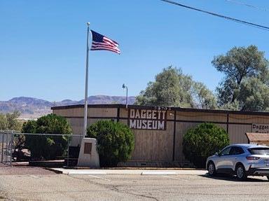
Turning on Mill Street, you will find the Community Park and the Historical Society Museum. The museum is located in the west end of the Daggett Community Services District building. The museum has a nice selection of artifacts and friendly docents to answer any questions. Along with historical displays related to mining, transportation, and agriculture, they recently added items from the now permanently closed Mother Road Route 66 Museum that was located at the Barstow Harvey House. At this time, the museum is only open Saturday afternoons. Just west of the park is the incredible Alf Blacksmith Shop. Seymour Alf had a freight business at the “Fish Ponds” area
west of Daggett. He moved to Daggett in 1885 and built a large blacksmith shop. Although he engaged in grading and road building, he is best known for building the large “twenty-mule team” freight wagons used to haul silver ore and borax to Daggett. The blacksmith shop looks like Mr. Alf may be back any minute as it is fully equipped. A covered area out back houses examples of the twenty-mule team wagons.
Across the Santa Fe tracks, and on the corner of National Trails Highway and Yermo-Daggett Road, you will find the building most commonly referred to as the Ski Lodge Roof House. This building was built in 1926 and was one of the first welcome centers in California. Located on the U.S. Route 66, it was across the street from the original agricultural inspection station. When the new inspection station was built east of town, the welcome center was sold and was used over the years as a land development office, a café, and finally as a private residence.
Grants have been applied for to fund the renovation of this building and the 1950s era Standard Gas Station next door to be used once again as a visitor/information center. Located on the Historic Route 66, this transportation-themed complex should be a must-see for the Route 66
“roadies” and tourists traveling the old “Mother Road.”
Two more museums are in the works. Although not in historic buildings, they are located behind the Stone Hotel. One will house historic mining exhibits. The other will be a museum dedicated to the Calico Print. The Calico Print was the Calico newspaper established in 1882. This museum will have a collection of printing presses and every issue ever printed by the Calico Print.
The Daggett-Calico Historical Society is a 501c3 non-profit. Their website has membership applications and a means to make tax deductible donations. Donations and volunteer help would be appreciated to help preserve this important part of our local history.
8:30am
Oasis Under The Trees
NESTLED UNDER A GROVE OF TREES , on a ten acre parcel of land, in the small town of Enoch, Utah, I stumbled across a hidden gem. The sign said, “Roadhouse BBQ.” When I arrived all I saw was a flag that said, “BBQ” with a gigantic white arrow pointing to a bunch of trees. As I approached the trees I discovered a path that meandered through the forest. Eventually I saw a clearing and an old barn began to come into view. A small metal sign that read “The Roadhouse BBQ” was on the ground leaning against the barn. A few feet away a red white and blue banner that said “Open” hung on the wall. Next to that a small door was open so I went inside. I was surprised to see a spacious dining room. The ceilings were tall and it had a rustic look about it. On one wall was a salad bar and on another sat a beautiful organ.
There was an adjoining room that had a small stage where a band could play in the colder months. As I exited that room it lead out to a large patio area with adjoining gardens. Outside was a huge stage in another barn where the Roadhouse Wranglers can be heard on Thursday and Saturday nights. Occasionally top name performers such as Wade Hayes can be heard on their stage.
The current owners Brad and Charlotte Lark purchased the land in September of 2020, during the Covid Pandemic. Along with the restaurant and music barn, the land also contains a house, several unique cabins and an RV park. The property is presently known as Willow Glen Resort.
Willow Glen was created in the early 1970’s by the previous owners, Philip and Violet Carter. The Carter’s had eight children. With their creative juices flowing and the help of their children, the Carter’s set out to build their dream home. Being
By Debbie Walker
a very frugal person and wanting the buildings to have a rustic feel, Violet set out to find salvaged lumber.
During the early 1980’s, she purchased a building called the Chauffeur’s Lodge for its scrap lumber. It was a small building in downtown Cedar City, that had been used to lodge bus drivers and other workers. It took the Carter family almost two years to dismantle the building by hand. They also collected other scrap materials such as logs, boulders, branches and any other rustic items they could find. Over the next five decades the cabins, buildings and grounds began to resemble Violets cherished home state of Virginia.
Currently the Willow Glen is used for weddings, parties, reunions and even an occasional funeral. With its newly opened RV park, amazing restaurant and weekly music events, the Willow Glen is the place to be.
The food at the Roadhouse BBQ is excellent. If you’re ever in the area you should definitely try Martha’s Macaroni and Cheese or her scrambled eggs. They are the best I’ve ever tasted. Who is Martha? You ask. Well, when she’s not working in the kitchen she can be found performing with the Roadhouse Wranglers. You might call her a Wranglerette.
Artistry Unleashed
What is ART?
Is it the same as ARTISTRY or ARTISTIC?
TO ME THE WORD IS SUBJECTIVE to whatever industry, topic or field of study that ignites an emotional response within.
Using an AI to research this topic, I found common ground within each definition example:
When asking, can you explain the Art of healing? The various responses were not surprising:
1. Holistic Approaches—Holistic healing considers the whole person, body, mind, spirit, and emotions. Techniques often include Acupuncture, Massage Therapy, Herbal Medicine, and Homeopathy.
2. Creative Arts Therapies – Art can be a powerful tool for healing; creative arts therapies include Art Therapy, Music Therapy, Dance/Movement Therapy
3. Mind-Body Practices – these practices focus on the connection between the mind and body: Meditation, Yoga, Tai Chi.
4. Energy Healing – Energy healing involves manipulating the body’s energy field: Reiki, Qi Gong
5. Counseling and Psychotherapy – Emotional and mental health are crucial for overall well-being: Cognitive Behavioral Therapy (CBT), Mindfulness-Based Stress Reduction (MBSR)
When asked to explain the art of architecture, the response was similar:
1. Definition and Purpose – Architecture is both an art and a science. It involves designing and constructing buildings and other structures that are not only functional but also aesthetically pleasing. The goal is to create spaces that meet people’s needs while inspiring and uplifting them.
2. Historical Significance—Throughout history, architecture has reflected the cultural values and technological advancements of societies, from the pyramids of Egypt to the cathedrals of Europe. Each era has its own distinctive architectural style.
3. Elements of Design – Architectural design includes several key elements: Form, Function, Space, Materials, Lights.
4. Styles and Movements – Architecture has various styles and movements, each with its own characteristics: Classical, Gothic, Modern, Postmodern.
Interestingly, when asked: “How are culinary talents a work of art?” again, the answer is not surprising:
1. Creativity and Innovation
2. Presentation and Aesthetics
3. Flavor and Balance
4. Cultural Expression
5. Sensory Experience
6. Technical Skill
Here is the biggest question of all: “What are the various art forms?” I hope these do not surprise anyone:
• Visual Arts – painting, sculpture, photography, drawing.
• Applied Arts – Architecture, graphic design, fashion design, ceramics.
• Performing Arts – Theater, Dance, Music, Opera.
• Literary Arts – Literature
• Digital Arts – Digital Art, Animation
• Conceptual Arts – Focusing on the idea rather than the finished product
• Folk Arts – Traditional art forms
• Martial Arts – combining physical movement with artistic expression in the form of technique
• Art of Animal Training – positive reinforcement, operant & classical conditioning, applications, organizations, and resources
While the comparison of art or artistry, or how artistic lends itself to recognition between industries, in the business world, they all have one thing in common: people.
Find out how being a chamber member benefits the community and your business. Look to your local chamber of commerce for networking, resources, and community support. Amplify your business impact; join the chamber today.
The Pinon Hills Chamber is proud to support and participate in the community event sponsored by the Phelan Chamber of Commerce on Saturday, October 5, 2024. We are encouraging everyone to stop by the Pinon Hills booth and complete a comment card on the various art displays.
If you’re not a member in Pinon Hills yet, let’s talk. Every business has a story to tell, we look forward to hearing how you started and how we can help you grow.
If you have any questions, reach out to 760-868-7191 or email info@pinonhillschamber.info
Marcy’s Musings The Historic Kemper Campbell Ranch Lives On
AFTER THE RESIDENTS of the Victor Valley endured over a week of bright orange and gray skies, choking smoke, and windblown ashes, the evening of Thursday Sept. 12 at the historic Kemper Campbell Ranch couldn’t have been more beautiful! Blue skies and no wind welcomed hundreds of Greater High Desert Chamber of Commerce members to the annual Kemper Campbell mixer, still hosted by members of the Campbell family. Dating from 1860 when it was known as the Rancho Verde, this beautiful guest ranch, once frequented by celebrities, artists, poets, and movie crews, is now home to numerous permanent residents, while also serving as a desert get-away for vacationers.
Representing the Mohahve Historical Society were Directors Mike Phillips and Scott Johnson, while Eric Mandesson and Marcy Taylor represented the Apple Valley Legacy Museum/ Victor Valley Legacy Museum projects. A large number of business sponsors made the event successful. Among the many raffle prizes were gift bags filled with historic collectibles from the two non-profits. The lucky recipients were happy to pose with their prizes.
Following the delicious dinner, which included a large assortment of desserts and drinks, Ranch Manager Peggy Shaughnessy shared a brief history of the ranch. GHD Chamber President/ CEO Mark Creffield followed, present
longtime Victorville resident, Attorney, and City Councilman Terry Caldwell with a well-deserved recognition plaque for his “support, devotion, and pioneering sponsorship of the Kemper Campbell Ranch Mixer.”
A great big thank you goes out to the GHD Chamber and the KC Ranch folks for putting on this amazing yearly event, where new members can get a dose of local history, while the long-time residents reminisce about the “good ol’ days” of cowboys and cattle drives, when celebrities frequented the old adobe buildings of this famous movie site and Hollywood hideaway.
The Golden Land of Apple Valley
IT WAS A NICE HOT SMOKY DAY as the Apple Valley Happy Trails Parade rolled down Highway 18 the morning of Sept. 7. The 41 entries included floats, equestrian units, mini Shriners’ cars, marching groups, school bands, civic organizations, church groups, vintage cars, a radio station, cheer squads, Marines, Veterans’ groups, karate kids, plumbing trucks, cement trucks, and Scout troops, all led by Sheriff Shannon Dicus and the Mounted Sheriff’s Rangers, and spied upon by a drone flying overhead.
Starting out as a part of the old Apple Valley Pow Wow Days celebrations held from 1948 until 1992, the parade morphed into Frontier Days and Round-up Days during the 1993-2006 era. After an eightyear hiatus, and by popular request, the parade was back, as “You can’t keep a good Town down!” The Apple Valley Legacy Museum has entered a creative themed float every year since the 2015 reinstatement of the parade under its current name, with museum volunteers joined by Mohahve Historical Society members the last three years.
Our 2024 entry, entitled “The Golden Land of Apple Valley,” showcased fourteen costumed riders, ranging in age from 21 to 89. Honoring the Town for giving us “A Better Way of Life,” our
song recognized the many activities and events that we residents can enjoy, making our Town an active and enjoyable place to live, work, and play. So attend the concerts, enjoy the pool, sign up to join a team, maybe play some golf or enter the Reverse Triathlon, and enjoy the many activities Park and Rec provides for all age groups. Conscientious residents might even consider adopting a pet or adopting a street, and most importantly, don’t forget to separate your trash!
Following the Parade the crowd rushed down to James Woody Park for the annual Car Show and Street Fair. Once again, the Apple Valley Legacy Museum and Mohahve Historical Society shared a booth space, with a variety of vintage items and local history books for sale. Lots of shoppers, both new and return visitors, a good number of sales, great volunteers, and the many folks that expressed their appreciation for our local history made for an enjoyable day.
A big shout out to all the talented volunteers who made our musical float come to life, to the driver and the photographer, to those who held down the fort in the park on a nice hot afternoon, and to the Town of Apple Valley and Village PBID folks for bringing us all together for this fantastic event.
Civilians Present to the Military
AT THE INVITATION of MHS Board
Member
and MOAA
Vice President Major Meera Maheswaran, currently in charge of programming, MHS Board Members Eric Mandeson, Delvin Harbour, and Marcella Taylor were the speakers at the monthly meeting of MOAA, the Mojave Desert Chapter of Military Officers Association of America. So on Wednesday, August 28, it was “Take Two” for our “Military’s Impact on the High Desert” presentation, previously given at the June 27 Mohahve Historical Society meeting at the Lone Wolf Colony. Nine MHS members, 4 with dual membership in the MHS and MOAA, as well as a large number of MOAA members, were present at Bear Valley Country Club in Spring Valley Lake. Attendees checked out our for-sale items, and browsed our displays of photos, news stories, and artifacts, including some large remnants of practice bombs dropped in Apple Valley during the late 1940s era. After a delicious lunch and a bit of socializing, it was SHOW TIME!
The power point presentation started back with the history of the early forts along the Mojave Road and the Army camel caravans, briefly covering the number of military bases currently in the area, and stressing the importance of both the Victor Valley and the Antelope Valley in the development and advancement of both aviation and the space program. During the World War II era, rural Apple Valley was considered to be “out in the middle of nowhere,” thus a perfect location to drop practice bombs onto gigantic bombing circles, preparing for the real thing.
The talk included a description and photos of the largest and most unusual fallout shelter in the country, built by Victor Valley locals inside the old Sidewinder Gold Mine, in what is now northeast Apple Valley. It was purported to house
up to 1000 people hundreds of feet underground for at least three weeks were a nuclear attack to occur, while those left outside met their unfortunate fate. Thankfully it was not needed for that purpose.
For three civilians presenting to a military audience with two former fighter pilots in attendance, we did a fair job, with only a few errors/clarifications pointed out. The Q and A session after the talk went like this:
Former Fighter Pilot: How did you get those aerial shots of the bomb circles?
Civilian presenter #1: Google Earth, how else?
Former Fighter Pilot: You could get a much better view from my plane. I fly over them all the time.
Civilian presenter #2: How many passengers can you take?
Former fighter pilot: ONE!
Civilian presenter #2: OK, thanks. We’ll make a sign-up list. That will make a nice future fieldtrip.
Thanks to Major Meera Maheswaran and the other members of MOAA for inviting us to speak to you. We truly enjoyed it and hope to see you again soon.
The Clampers Commemorate Ludlow
MOHAHVE HISTORICAL SOCIETY member Bonnie Ingram, AKA Boni on the Keys, recently passed through the small town of Ludlow, and lo and behold,
discovered two monuments placed by E Clampus Vitus, one on each side of the Ludlow (Route 66) Cafe. To get there, take the I-15 to Barstow, then head east on the I-40 until you see the Ludlow sign, directing you down the historic Route 66 to the cafe.
The marker to the right of the mining cars commemorates “Project Carryall,” a 1963 plan to realign the Atchison, Topeka, and Santa Fe railroad lines, using 23 nuclear explosions totaling 18 megatons to excavate a two-mile cut as much as 350 feet deep through the Bristol Mountains. The project idea was dropped in 1962 due to health and environmental concerns. The plaque was placed in 2010.
Just to the left of the mining cars is the T & T plaque, officially titled “Tonopah
and Tidewater Railroad Shops,” recognizing the facility that for 18 years serviced the locomotives and rolling stock of the Nevada Shortline. The 26 miles of track between Ludlow and Crucero were abandoned in 1933, and only the road bed remains. The plaque was placed in 2007.
Thanks to Bonnie and her daughter Jamie Cordova (the photographer) for sharing these tidbits of local history. Be sure to make a stop in Ludlow the next time you’re passing by.
“Stagecoach” Races Across the Screen
THANKS TO VP DELVIN
INSTALLING a new movie screen, and Director Eric manning the projector, our second summer movie night was a great success, with 47 in attendance on a beautiful desert evening. And let’s not forget MHS members Alyson, Patty, Jada, and Carol J., who worked to make sure all in attendance were well taken care of.
The 1939 John Wayne movie, directed by John Ford, was much more than most people expected, i.e. “over the top” fantastic! The beautiful scenery, outstanding music and sound effects, expert horsemanship, superb acting and
directing, all came together to bring this exciting and thrilling adventure story to the big screen. And we, the audience, watching 85 years later, took a step back in time to see history come to life. The scenes of the peaceful Navajo Nation Indians playing the role of the warlike Apaches, with Hollywood stuntman
Yakima Canutt performing one of the greatest stunts of all times, were filmed just a few miles east of us on a Lucerne Valley dry lake bed.
Thanks to all who attended to support two non-profits, MHS and the AV Legacy Museum, who share the common purpose of preserving and sharing local history.
Coming in for a Landing at Edwards Air Force Base
ON FRIDAY AUG. 3, 2025 , 29 Mohahve Historical Society members met at the West Gate of Edwards Air Force Base for the opportunity to tour the Base, and to see the Flight Test Museum and Yeager Park. Our knowledgeable tour guides included Art Thompson, Chairman of the Flight Test Museum Foundation; Lt. Col. Rex Moen, Chairman of the Friends of the Flight Test Museum Foundation; Col. Jimmy Doolittle III, grandson of Five Star General Jimmy Doolittle; David Smith of the Speakers Bureau; George Welch, Flight Test Museum Director; Major James E. Brown, President of the National Test Pilot School; and Lisa Brown, Director of Education and Community Relations. Both Edwards AFB and George AFB played important roles in shaping desert aviation history. While
Captain Joseph McConnell’s replica plane Beauteous Butch is on display at the Apple Valley Airport, we observed Brig. Gen. Chuck Yeager’s replica Glamorous Glennis hanging from the Flight Test Museum’s ceiling. These two famous well-known pilots were both connected with George and Edwards, with Yeager’s family living for several years in Victorville, and McConnell’s family living for many years in Apple Valley, even after his untimely death at age 32. Yeager, on the other hand, lived to the ripe old age of 97, and was active in the Victor Valley for many years, periodically wowing residents with his aviation skills. While McConnell is best remembered as a Triple Jet Ace of the Korean War, Yeager is most well-known for being the first human being to fly faster than the speed of sound, i.e. breaking the Sound Barrier.
The Mohahve Historical Society is proud to be a Friend of the Flight Test Museum at the Bronze Level, with donated funds going towards building a new and much larger museum outside the gate, thus allowing for public access. We hope that our first monument, “Sound Barrier Cracked,” placed in 1988 to honor Captain Chuck Yeager, along with the bronze Yeager Statue, will move to the new location.
After a complimentary lunch, a browse around the gift shop, and a bus ride back to the parking lot, we took a look at the frame of the museum-to-be. Nearby we were happy to find six bricks in the Heritage Walk, placed by the following members: Ralph and Kelly Chavez, Gari Meade, Clara Petrosky, Mike Phillips, Marcy Taylor, and Blanche Trujillo. If you wish to contribute to this worthy history-preserving project, it’s not too late to add your brick to the Heritage Walk.
Upcoming Community Events
Thurs. Oct. 3- Leo Eiffert’s Musical Tribute to benefit Apple Valley Legacy Museum 5-7:00 Museum porch
Tues. Oct. 8- Friends of the Apple Valley Library meeting- Ca. Writers Club presentation 11:00
Wed. Oct. 9- Groundbreaking of new Apple Valley Capt. McConnell Park 8:00 AM Navajo and PahUte
Sat. Oct. 19- Santa Fe Trading Co. Crafts Fair (rescheduled) 10-4:00 Old Town 7th Street
Thurs. Oct. 24- Mohahve Historical Society meeting- Mark Landis -Arrowhead Water Train 6:30 Lone Wolf Colony
Sat. Oct. 26- Mohahve Historical Society Fieldtrip to Granger (Cross-Eyed Cow) Farm- 10:00 Helendale
The Curious Case of the
Cronese Cat
FIGURING OUT THE ORIGIN
of the Cronese Cat’s name has just about as many theories as a storybook feline has lives. It was believed the natural wonder is either named for early explorer and author Titus Fey Cronise or William H.V. Cronise. In 1870, both were officers of the Piute Mining Company. Early homesteader Elmo Proctor offered another theory. He said “cronese” was the corruption of the Paiute word for “wildcat” and refers to the hanging sand dune above the lake which resembles a resting cat.
Desert Magazine, August 1942
“The Cat on the Hill…Several years ago there were inquiries as to the origin of name Cronese (appearing on most maps as Cronise). I had heard that it was an Indian word meaning wildcat, and that the Indians so named it because of the cat’s image that sits on Cat mountain. But the Automobile club insists it was named after a scientist named Cronise, who wrote about the Mojave in 1880. I have talked with several old desert men who visited the valley in the ’60s and they say it was
By Jaylyn And John Earl www.thedesertway.com
named Cronese then, which was 20 years before Mr. Cronise’s visit here. A short time ago I had a long visit with a Pahute Indian…I asked him to say “wildcat” in his language. He pronounced it CROdthESE. The dth [sound] is slurred and subdued so that it sounds like an “n,” but if you pronounce it “n” they will correct you. There is no doubt that the Pahutes saw the cat on the hill. (Signed) Elmo Proctor, Yermo, California.”
To complicate things even more, the community and station are spelled with an “e” (Cronese) but the spring, mountains, valley and lakes are spelled with an “i” (Cronise).
The Cronese Cat has other names too. Many know it as “Cat Mountain,” while the lower part is sometimes referred to as “Kitten Dune.” Mother Nature’s artwork looks like the back of a giant cat sitting on its haunches with its ears perked up, perhaps ever-vigilant for a giant mouse in the heart of the mountain.
Photo courtesy of Larry Vrenburgh.
According to Journal of Geology, “The source of sand is believed to be the adjacent Cronese Lake basins, but the volume of eolian sands in the area may indicate an additional source in the
Photo courtesy: Eastern California Museum; Frasher Foto. Cronese Flood, February 1927. Photo courtesy of Keith B. Rosenberg.
paleolake Mannix basin to the west. The most prominent of the dunes is the Cat Dune, a falling dune that fills a ravine between elevations of 370 and 670m on the east side of the Cronese Mountains. The dune is indurated and its surface is covered by a thin angular gravel talus. At the base of the main dune is a smaller
talus-covered falling dune informally named the “Kitten Dune.” (Evans, 1961)
Four of Keith B. Rosenberg’s great aunts at the base of the “Cat,” May 8, 1932. Photo courtesy of Keith B. Rosenberg. Elmo Proctor built Cronese Station in 1925. When the highway was rerouted in 1934, he moved his family and business
QUARTERMANIA
WEDNESDAY
NOVEMBER 13, 2024
Elks Lodge 9202 ‘E’ Avenue, Hesperia
Doors open at: 5:00pm Holiday Shopping & Full Bar Available 6:00pm Dinner
Each Auction will have a $40+ retail value $25 ADMISSION includes dinner one bidding paddle
6:30 Quartermania
Increase your chances add’l paddles $3 each Bring 2 or 3 Rolls of Quarters Purchase Tickets ONLINE -No Tickets Sales at the Door
two miles to Cronese Cove on the south side of Highway 91, 18 miles west of Baker. It was known as Proctor’s Station and Cafe. Elmo Proctor continued to own and operate it until the 1960s, when Interstate 15 was realigned.
Elmo Proctor’s father was Elon Chrysler Proctor. Nona Proctor was Elmo and Ella Mae Wright Proctor’s oldest daughter. She married Harry Weldon Rosenberg in 1927. Their son, Dr. Harry Rosenberg, wrote Life Along the T & T.
Elmo Proctor is Ethel Rook Messer’s grandfather. Ethel passed away on June 24, 2020. She was the beloved manager of Shoshone Museum whose heart and soul was local history and so much more. I’m honored to have called Ethel my friend.
Location
The Cronise Mountain range is located in the east Mojave Desert, north of Interstate 15, southwest of the town of Baker, California, between Baker and Yermo at coordinates 35.113871°N 116.313909°W
Please refer to thedesertway.com for citations and recommended resources.
Photo courtesy of Larry Vrenburgh.
What’s in a Name?
Grand Cannyon
by Jorge Leandro Rodrigues
THE GRAND CANYON offers one of the most visible examples of a worldwide geological phenomenon known as the Great Unconformity, in which 250 millionyear-old rock strata lie back-to-back with 1.2 billionyear-old rocks. What happened during the hundreds of millions of years between remains largely a mystery
In 1869, a man named John Wesley Powell observed that several layers of rock that should’ve been in the Canyon walls
Play with it!
were not present. More than a billion years of rock are missing from the walls.
The Grand Canyon represents wonder, freedom, and the adventurous spirit of the United States. Often called “The Great Unknown”, the Grand Canyon was a literal blank spot on the map until Joseph Christmas Ives sailed up the Colorado River in search of a trade route to the West