7 minute read
DESIGN: PROPOSED IMPROVEMENTS
by REA site


Advertisement

DESIGN: PROPOSED IMPROVEMENTS
• For Main Street, reconstruct part of the street as a pedestrian plaza that removes the need for curbs and allows positive drainage away from the buildings. This will allow the remainder of the narrowed street to be used by vehicles during normal business hours, but will allow the street to be shut down and used as a pedestrian gathering area for special events.

Sidewalks
In general, sidewalks should be free of obstructions and provide adequate passing space for pedestrians. Sidewalk grading should be smooth and without breaks. At intersections, every sidewalk should include a curb ramp with a contrasting, detectable warning and a clear landing at the top of the ramp. Detectable warnings are often in the form of raised tactile devices. Raised tactile devices alert people with visual impairments to changes in the pedestrian environment. They are often used at:
• The edge of depressed corners
• The border of raised crosswalks and intersections
• The base of curb ramps
• The border of medians
Contrast between the raised tactile devices and the surrounding pavement is important as it alerts people with low vision to the presence of the devices. All new sidewalks and sidewalk reconstructions should contain ADA compliant curb ramps. Existing curb ramps that are not compliant should be replaced as resources become available.

DESIGN: PROPOSED IMPROVEMENTS
Crosswalks
Just as it is important for people to be able to safely walk along streets, people must be able to safely cross streets. Crossing a street should be easy, safe, convenient, and comfortable. A number of tools are available to improve safety and make crossing easier. Crosswalks are used to assist pedestrians in crossing streets and help to alert motorists to their possible presence. Crosswalks legally exist at intersections whether they are marked or not, unless the pedestrian crossing is specifically prohibited. At non-intersections, crosswalk markings are used to legally establish the crosswalk. Parallel striping is the most basic type of crosswalk marking. Continental or ladder crosswalk markings provide greater visibility of the crossing location. The ladder style crosswalk is recommended to be the standard in Frankfort. Decorative pavements, brick pavers, and other enhanced markings may be used to enhance the aesthetic appearance of crosswalks at key locations.
In developing a complete and connected pedestrian system, crosswalks should not be isolated to intersections. Appropriate locations for marked crosswalks are:
• All signalized intersections
• Crossings near transit facilities

• Trail/path/greenway crossings
• Near land uses that generate high pedestrian volumes
• Where there is a preferred crossing location due to sight distance

Higher visibility crosswalk treatments, including raised crosswalks or intersections, rectangular rapid flashing beacons, in-street signage, and pedestrian hybrid beacons, are beneficial where pedestrian volumes are expected to be higher and/or pedestrian vulnerability is increased. This includes school zones, mid-block crossings, and at unsignalized intersections. It is important to note that at unsignalized intersections where vehicular speeds exceed 40 miles per hour, marked crosswalks alone should not be used.
DESIGN: PROPOSED IMPROVEMENTS
Downtown Park

Located on the city-owned lots near the intersection of Washington Street and Prairie Creek, a new urban park is central in making the downtown attractive to a wider range of residents and visitors while also attracting investment for new development and redevelopment. This prominent location is ideal for a park given its visibility and centralized location, uniquely sited in a prime redevelopment area, and on the banks of Prairie Creek.
Features in downtown urban parks should include an open lawn for general gathering and play as well as viewing performances on a proposed event stage and canopy. During the winter, the lawn can repurpose as an ice skating rink to maintain seasonal interest. Additionally, the park should include a spray pad or some other form of water play to be enjoyed by families with children. Other features recommended for the park include public artworks, shaded seating areas, playgrounds, food vendor spaces, spaces for reflection, and bicycle parking.

DESIGN: PROPOSED IMPROVEMENTS
MULTI-USE TRAILS
Multi-use paths and bicycle facilities can take a variety of forms and can be designed in a multitude of ways. When planning for these facilities, it is important to consider the context within which the trail or path will be located and the design standards that are offered by organizations such as the National Association of City Transportation Officials (NACTO). For instance, in a rural area with limited vehicular traffic and a lot of open space, a simple asphalt path may be appropriate. In an urban area, where there is a lot of activity, and potential for conflict between trail users and vehicles, it may be more appropriate to consider a facility such as a protected cycle track.
Cycle tracks are the most attractive facilities for various user groups and are the safest facilities for families using trails. They are visually distinct and offer amenities such as wayfinding signage, lighting, benches, and unique pavements. Cycle tracks have also been determined to encourage healthy living, improve local real estate values, and encourage new development and investment.
It is recommended that as the proposed trail system connects various points of interest throughout the City’s corporate limits, and specifically downtown, consideration be given to constructing it as a protected cycle track. Protected cycle tracks separate the trail use from the street, and in many cases, separate the trail from the sidewalk. This is an ideal design in urban areas where the trail will be located immediately adjacent to storefronts. By separating the uses, the potential for conflict between the various user groups is minimized.
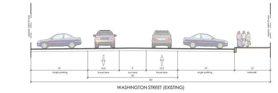
Through downtown Frankfort, consideration should be given to developing a separated-use cycle track along the northern edge of Washington Street between Columbia Street and Prairie Creek. This would require the shifting of the northern curb line and changing existing angled parking to parallel parking, resulting in an estimated total loss of eighteen parking spaces. Angled parking could be maintained along the southern curb line. West of Columbia Street, as the trail travels towards the old railyard, the trail could convert to a shared-use trail, replacing the existing sidewalk, and utilizing the large tree lawn that is available.

It should be noted that while the loss of any on-street parking will be a controversial subject, the benefits of the multi-modal facilities will far outweigh the disadvantages of lost parking; parking which can be easily restored and accommodated in other, convenient
DESIGN: PROPOSED IMPROVEMENTS
locations through means previously discussed in the existing conditions portion of this report.
• Locate signs at heavily trafficked and key places such as downtown, parks, key intersections, and along proposed trail corridors.
Adjacent to Prairie Creek, the cycle track would travel east along the north side of Washington Street as a shared-use trail, providing a connection to Frankfort High School and Frankfort Middle School. While this would just provide one leg to a trail, connecting routes should link to the plans laid out in the Frankfort Bicycle and Pedestrian Plan.
Temporary improvements for implementing the trail facility may include patching ravelling sidewalks and installing signage and benches to aid in accessibility and wayfinding, but the long-term plan should be to construct an asphalt or paver pathway meeting NACTO standards.
Public Sign Systems
While business and building signage is covered under the “Element: The Buildings” section, improvements to wayfinding signage are recommended within this section to enhance navigability throughout the Frankfort community for both pedestrians and motorists.
Suggested improvements include:
• Develop a design standard for public signage within Frankfort that offers at least two types of signs: smaller, more detailed signs located along walks and directed towards pedestrians, and larger, less detailed signs directed towards motorists.
• Develop a physical design character for the signage that has an urban yet historical character and complements other streetscape amenities such as benches, litter receptacles, street lights, and planters.
• List points of interest and provide directional markings and distances. Signs designed for pedestrians can also offer interpretive information about historic, cultural, and social places and events and can provide key maps of the larger community.

DESIGN: PROPOSED IMPROVEMENTS
Site Furnishings
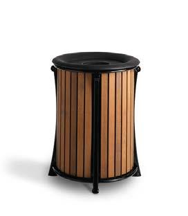
New site furnishings are recommended throughout downtown Frankfort and should include benches and litter receptacles at a minimum. These amenities will provide character to the streetscape, seating opportunities, and help to maintain the downtown’s cleanliness.

Specific recommendations for site furnishings include:
• Select furnishings that have a similar character and complement the other streetscape amenities including benches, litter receptacles, street lights, and planters.

• Place furnishings at common intervals and locations that are used by downtown patrons and do not impede pedestrian circulation by placing items directly in a path of travel.
Street Lighting
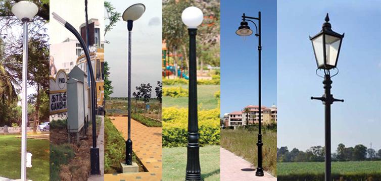
Street lighting is a critical component for a downtown such as Frankfort’s. It not only provides security in the evening, but acts as an amenity that can add to, or detract from, the downtown’s character. Street lighting can also provide multiple functions, and offer opportunities for banners that highlight local events or celebrations, as well as offer arms for hanging baskets and plantings.
Specific recommendations for street lighting include:

• Select lights that have a similar character and complement the other streetscape amenities including benches, litter receptacles, street lights, and planters.
• Select lights that are pedestrian scaled, twelve to fourteen feet tall and that illuminate both the sidewalk and roadway.
• Locate lights at regular intervals.
• Select high efficiency fixtures such as LED that will be low maintenance.
DESIGN: PROPOSED IMPROVEMENTS
Street Plantings
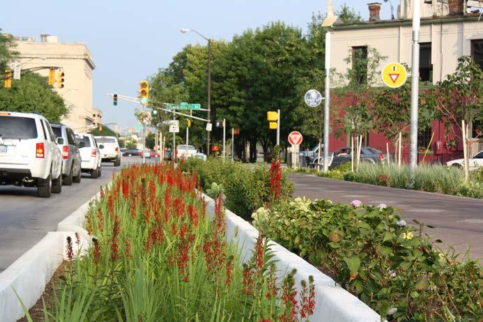
Street plantings of a variety of types provide color to an urban area that can make it feel warm and inviting. They also provide functional purposes that offer shade to downtown patrons and can be used to cleanse and treat stormwater. Plantings can be provided in a variety of ways that include above-grade planters, in-grade/depressed planters, hanging baskets, and at curb bumpouts.
When considering street plantings, specific recommendations include:

• Select perennials and annuals that are relatively low maintenance.
• When using above-grade planters, select planters that complement other downtown site furnishings and that are movable in lieu of fixed constructions. Movable planters offer more flexibility in the design and use of the streetscape.
When using trees, select trees that have an upright branching habit to minimize the need for pruning and to minimize conflict with pedestrians and vehicles. Select trees that do not bear nuts or fruit as they become a nusiance when maintaining downtown sidewalks and also attract birds and other wildlife.
DESIGN: PROPOSED IMPROVEMENTS
Gateways
A gateway is a marker that announces arrival, or serves as a landmark, in a place and that helps a community evoke a specific brand or character. Gateways can be of a variety of types and sizes, and can occur in a variety of locations. Gateways can span roadways, or be located within or adjacent to roadways. The City of Frankfort has limited signage located at the corporate limits that announces arrival to the community. Within Frankfort, there are no real gateways to the downtown.
Recommendations for gateways within the City of Frankfort include:
• Develop gateways with a similar character that evoke a character/brand/theme by which the City of Frankfort can be identified.

• Construct new gateways along all of the major routes into the city (SR 39 and SR 28).

• Construct a new gateway at the intersection of Jackson and Walnut Streets.
• Construct new gateways along the new Washington Street corridor— one near Prairie Creek and one near the old railyard, future home to.


