ISSN 2348-1218 (print)
International Journal of Interdisciplinary Research and Innovations ISSN 2348-1226 (online) Vol. 8, Issue 2, pp: (8-16), Month: April - June 2020, Available at: www.researchpublish.com

ISSN 2348-1218 (print)
International Journal of Interdisciplinary Research and Innovations ISSN 2348-1226 (online) Vol. 8, Issue 2, pp: (8-16), Month: April - June 2020, Available at: www.researchpublish.com
Department of Geography and Resource Management, Mizoram University (A Central University), Aizawl – 796004, India
Email: sati.vp@gmail.com
Abstract: This study examines the increasing incidences of cloudburst triggered debris-flows/flash floods in the Garhwal Himalaya, India. Data were gathered through the case studies of three incidences that occurred during the monsoon season – July, August, and September 2019. A total of 24 people died and 39 people were injured due to the cloudburst triggered debris-flows and flash floods events during the period. Further, about 150 roads were blocked and several houses, cowsheds, and agricultural land were drowned during the same time. This study reveals that most of the death and loss of property occurred along the river valleys because of the construction of houses on the fragile landscapes of these rivers’ banks. This study suggests that the construction of settlements should be avoided along the river valleys or on fragile landscapes. Economic activities should also be avoided in these fragile locations.
Keywords: Debris-flows, flash floods, cloudburst, Garhwal Himalaya.
Cloudburst can be defined as a sudden heavy rain shower that occurs within a particular space and a short span of time (Sati and Maikhuri 1992) It triggers the occurrences of huge debris flows and flood floods. Debris flows and flash floods are synonymous. However, the amount of debris and water distinguishes them. Flash floods mainly occur along the river valleys, both sides of the streams whereas debris flows occur along the hill slopes, which comprise high slope gradients and fragile landscapes. Both debris flows and flash floods are very common, frequent and intensive in the Garhwal Himalaya and as a result, the entire region is worst affected. These hazards become more violent/disastrous, when they occur in the human settlements, cause the death of humans and animals, and the loss of properties and infrastructure The high landscape fragility, instability of terrain, and intensive anthropogenic activities accentuate the magnitude of debris flows and flash floods, causing serious environmental degradation and huge loss of lives and property (Sati 2008) Every year, several debris flows and flash floods events occur in the Garhwal Himalaya. These events are accounting for more than 70% of all the economic losses and more than half of the casualties (Sati 2011) In the recent past, the Garhwal Himalaya has received high climate variability and change. The valley regions are warming and the middle altitude and the highlands are affecting with intensive and scanty of rainfall. High variability and change in climate have increased the frequency and intensity of rainfall, leading to flash floods and landslides in the Garhwal Himalaya (Chalise and Khanal 2001; ICIMOD 2007; ICIMOD 2007; Bhandari 1994; Kumar et al 2006; Uttarakhand 2017; Ives and Messerli 1989; Solomon et al 2007; Du et al 2004; Bandyopadhyay 1994; Sati 2013) during the recent past.
The Garhwal Himalaya of the Indian Central Himalayan Region (ICHR) is one of the most fragile landscapes, which is highly vulnerable to natural hazards. It receives heavy rainfall mainly during the three months of monsoon season – July, August, and September, every year. There are several rivers – the Yamuna River and its tributaries, the Bhagirathi River and its tributaries and the Alaknanda River and its tributaries – originate and flow in the Garhwal Himalaya and many of
ISSN 2348-1218 (print)
International Journal of Interdisciplinary Research and Innovations ISSN 2348-1226 (online) Vol. 8, Issue 2, pp: (8-16), Month: April - June 2020, Available at: www.researchpublish.com
them are glacial fed perennial rivers. During the monsoon season, they flow above the denser marks. Even, the seasonal streams become violent The watersheds are big, where huge water accumulates and flows with high volume and velocity through the river valleys. Cloudburst triggered debris flows and flash floods are very common during the monsoon season. Occurrences of large landslides and mass movements are also caused due to heavy downpour during the same time Several incidences have occurred in the entire Garhwal Himalaya during the past decades, which has led to huge loss of lives and damage to existing infrastructure, properties, and agricultural and forestlands (Sati 2013)
It has been observed that the incidences of cloudburst triggered debris flows and flash floods have increased during the last decades The increasing variability in climatic conditions such as high intensity, and irregular and unseasonal rainfall have further accentuated rainfall intensity and frequency. The severity of disasters has increased because of the growing population and a large scale construction of settlements along the river valleys and fragile landscapes This study examines the increasing shreds of evidence of debris flows and flash floods in the Garhwal Himalaya, India. The study also aims to assess the major driving forces that cause the occurrence of these disasters. A study of cloudburst events that triggered debris flows and flash floods in the three months of monsoon season i.e. July, August, and September 2019 was conducted in the Garhwal Himalaya. Further, a case study of three debris flows and flash floods affected areas was conducted.
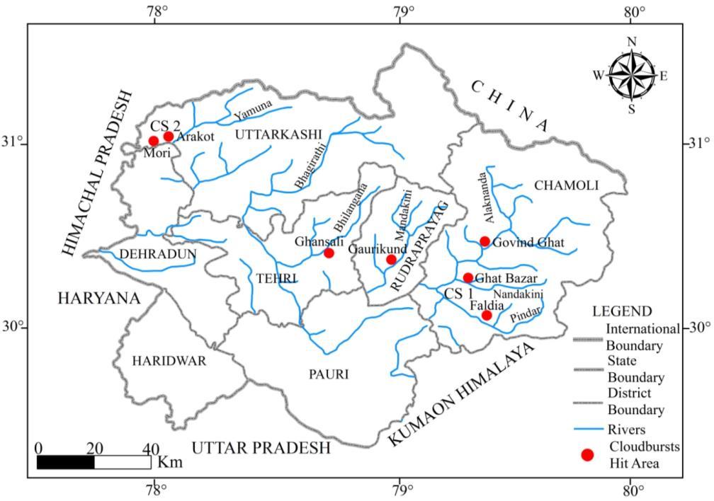
The Garhwal Himalaya stretches between 29o31’9” N – 31o26’5” N and 77o33’5” E – 80o6’0” E and covers an area of about 29,089 km2, of which, 92.6% land is mountainous mainland (Figure 1). Out of the total mountainous area, about 16% of areas are snow-covered. The Garhwal Himalaya is inhabited by 59% of the total state population. It is an integral part of the Uttarakhand Himalaya, characterized by a fragile landscape and rough, rugged, and precipitous terrain Altitude ranges from 300 m to >7,000 m and it comprises four landscapes – the great Himalayan ranges, middle Himalayan, lower Himalayan/ Shivalik ranges, and Doon Valley. It has seven administrative districts – Hardwar and Dehradun (partially) are located in plain areas while Chamoli, Rudraprayag, Pauri, Tehri and Uttarkashi districts are mountainous. The mountainous districts are ecologically fragile and highly vulnerable to weather-induced disasters. Monsoon rain occurs mainly during the three months – July, August, and September with high intensity and frequency that leads to severe natural catastrophes. Rain also occurs during the winter season through Western Disturbances, causing heavy snowfall in the middle and higher altitudes of the region. Seasonal changes have been observed in both summer and winter rainfall.
ISSN 2348-1218 (print)
International Journal of Interdisciplinary Research and Innovations ISSN 2348-1226 (online) Vol. 8, Issue 2, pp: (8-16), Month: April - June 2020, Available at: www.researchpublish.com
Empirical data were collected through the extensive field visit of the Garhwal region, mainly Chamoli and Uttarkashi districts during the three months of July, August, and September 2019. Data on loss of lives, damage of houses, agricultural land, and infrastructure were collected during the field visit. Environmental degradation such as forest depletion, landslides, and landscape degradation was assessed. Data on major cloudburst triggered debris flows and flash flood incidences were analyzed and the economic and environmental impacts of these incidences were assessed. The study has been divided into three sections In the first section, a case study of the cloudburst triggered debris flows and flash floods that have occurred in various places of Chamoli district was carried out. The second case study is related to the debris flows/flash floods that have occurred in three various places of Uttarkashi district. And the last section is about the other incidences, which have occurred during the period in the entire Garhwal region. A detailed analysis of the causes and consequences of debris flows/flash floods, mainly in the Garhwal region was carried out.
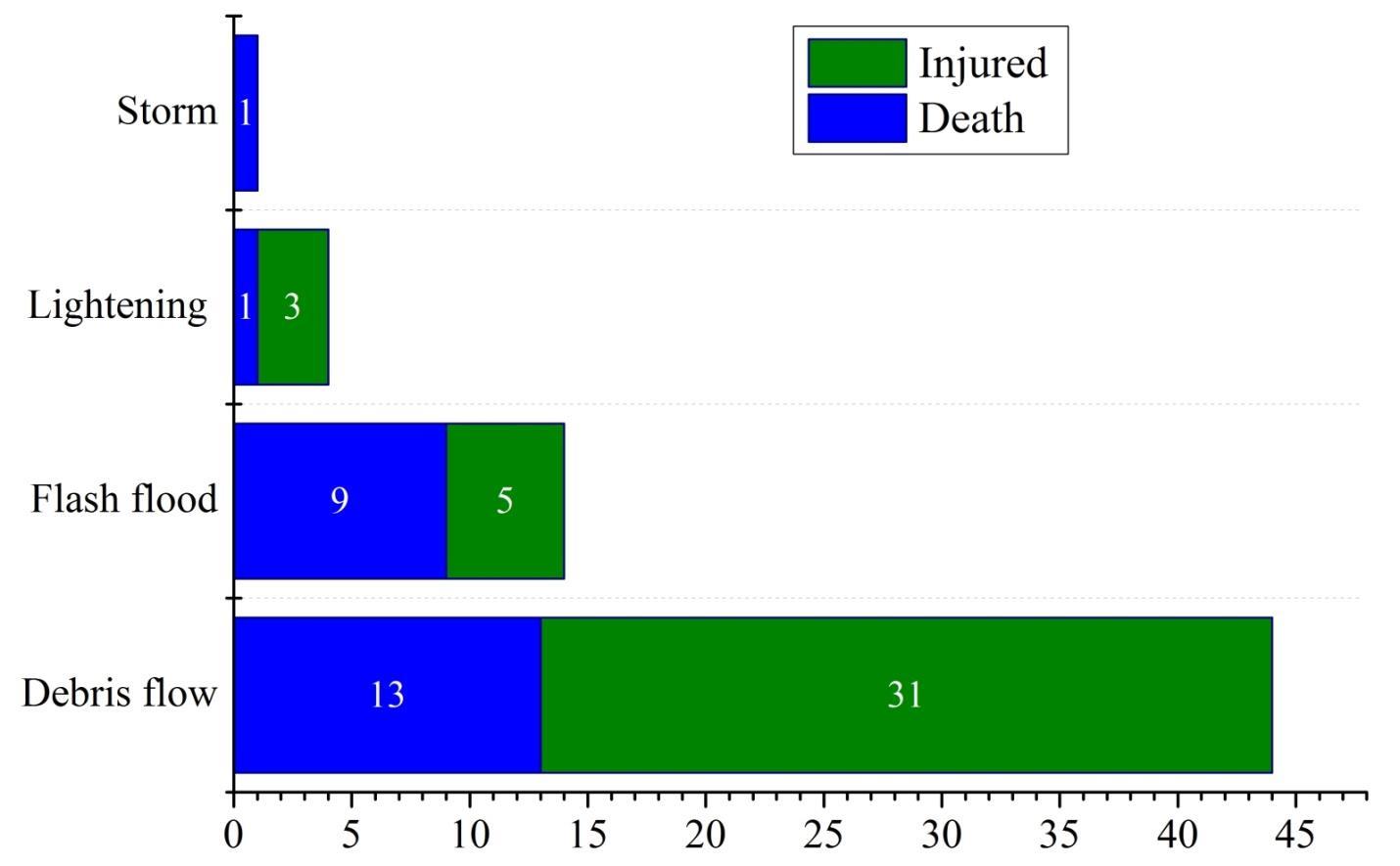
During the three months of monsoon season, the major disasters that occurred in the Garhwal region were landslides, cloudburst triggered debris flow and flash floods, lightning, storms, and others. Debris flows were the major disasters’ events, due to which, 13 people have died and 31 were injured (Figure 2). Flash floods events were the second disastrous events, which has led to the death of nine people and five were injured. Due to lightening, one person died and the other three were injured. One person was died due to a storm. As a whole, a total number of 45 people have died and 39 people were injured due to the cloudburst triggered disastrous.
 Source By author
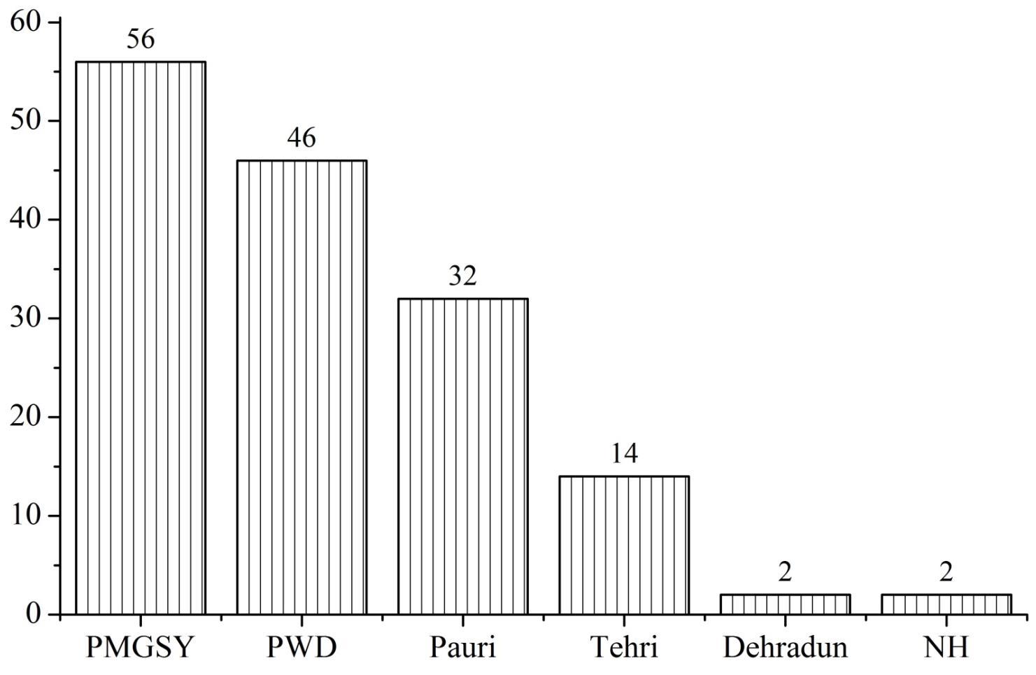
Data were gathered on the major road blockages and damage of roads in the different districts of the Garhwal region. The highest number of roads were blocked and damaged under the Prime Minister Gramin Sadak Yojana (PMGASY), which were 56 in number, followed by the roads, which are constructed and maintained by the Public Work Department (PWD), which were 46 in numbers. At the district level, the highest road blockages and damages were noticed in the Pauri district (32) followed by Tehri (14), and Dehradun (2). Two national highways (NH) were also damaged during the period. A total of 150 roads were blocked and damaged in the Garhwal region during the three months (Figure 3)
ISSN 2348-1218 (print)
International Journal of Interdisciplinary Research and Innovations ISSN 2348-1226 (online) Vol. 8, Issue 2, pp: (8-16), Month: April - June 2020, Available at: www.researchpublish.com
4.3. Case Studies
The Chamoli district lies in the north part of the Garhwal region, borders with Tibet (China) in the north, the Kumaon Himalaya in the east, and Rudraprayag and Uttarkashi in the west It is a mountainous district and a large part of it is snow-covered accounts for 16% of the total geographical area. A number of large glaciers are found in the district. The famous Alaknanda River, its four major tributaries – the Vishnu Ganga, the Dhauli Ganga, the Nandakini, and the Pindar rivers, and several minor perennial streams originate from the glaciers and flow through the district The whole district is highly influenced by the Great Himalayan Ranges and as a result, the district receives heavy rainfall during the monsoon season. In several times, the rivers flow above the danger marks and the low lying areas are inundated. Further, the entire district is ecologically fragile and the risk and vulnerability of hazards are enormous. The river valleys are densely populated where human habitats are constructed along the river banks, and on the fragile slopes.
In the months of July, August, and September 2019, the entire district received a number of cloudbursts events, which has resulted in a huge loss of lives and property, including infrastructure, human habitats and agricultural fields. Table 1 shows cloudbursts triggered debris flows and flash floods in several locations of the district. On August 8, 2019, debris flow, which was triggered by a cloudburst, devastated the Faldia village, lies in the Deval block in the right bank of the Pindar River (Figure 4 A). Due to debris flow, two women have died and 18 animals were drowned. A total of 12 houses and eight cowsheds were fully damaged. In terms of infrastructural facilities, three bridges were collapsed and drowned and a large proportion of agricultural land (four ha) was washed away On the same day (i.e. August 8, 2019), cloudburst triggered debris flow occurred in the Mainthana village, which lies on the way to the Badrinath pilgrimage near Langasu in Chamoli district. As a consequence of the incident, two houses were collapsed and a large proportion of arable land was washed away
One of the biggest incidences occurred in the Nandakini River valley in Ghat development block of the Chamoli District on August 12, 2019. Cloudburst triggered a flash flood that occurred in the Chufalgarh, a tributary of the Nandakini River, which has fully affected the Banjbagar, Lankhi, and Ali villages. Old Bazar of Ghat (Figure 4 B), which is located on the left bank of Chufalgarh, was largely damaged. Due to flash floods, six people have died and 40 animals were drowned. In
ISSN 2348-1218 (print)
International Journal of Interdisciplinary Research and Innovations ISSN 2348-1226 (online)
Vol. 8, Issue 2, pp: (8-16), Month: April - June 2020, Available at: www.researchpublish.com
addition, two houses were drowned and several houses were damaged. A large proportion of roads were washed away On September 7, 2019, cloudburst triggered flash floods and debris flows occurred in 13 villages of the Upper Pindar River, which are Gudam, Thala, Lolti, Gwaldom, Talwadi, Bainoli, Vijaypur, Jatera, Sera, Jaula, Buljuala, Trikot, and Chidinga. About four houses were fully damaged. A large proportion of agricultural land and forest areas were washed away. Debris entered into about 12 human habitats and cowsheds and damaged them. On the same day, 40 motor vehicles were drowned with a flash flood, four shops were fully damaged and 30 m long national high way was drowned in Govindghat, lies in the right bank of the Vishnu Ganga (also known the Alaknanda River). In Ghat block of Chamoli district, cloudburst triggered debris flow once again occurred in the Dhurma village on September 7, 2019. Huge debris entered into the middle of the Dhurma village, which has damaged a number of human habitats and washed away a large proportion of the agricultural land.
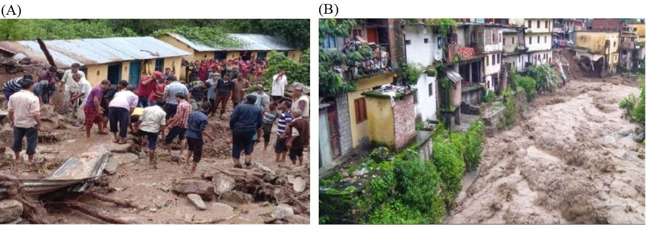
Table 1: Debris flows/flash floods occurred in several places of the Chamoli district
Affected villages/River basin/Date
Loss of lives Loss of properties
Faldia village, Pindar River Basin on August 8, 2019 Two women died and 18 animal drowned
Maithana village, Alaknanda River Basin on August 8, 2019 Nil
Bhanjbagar, Lankhi, Ali villages and Old Bazar of Ghat, Chufalgarh, a tributary of the Nandakini River on August 12, 2019
Gudam, Thala, Lolti villages (Jamun Srot) A total of 10 villages – Gwaldom, Talwadi, Bainauli, Vijaypur, Jatera, Sera, Jaula, Buljaula, Trikot, and Chidinga villages were affected, Pindar River Basin on September 7, 2019
Six people died and 40 animals were drowned
Nil
Total 12 houses and eight cowsheds were fully damaged, agricultural land and three bridges were washed away
Two houses were collapsed
Two houses were drowned, several other houses were damaged and the road was drowned in several places
Four houses were partially damaged, agricultural land was drowned and debris entered into more than 12 houses and cowsheds.
Govindghat, Vishnuganga valley on September 7, 2019 Nil
About 40 motor vehicles were drowned with debris, four shops were damaged, and 30 m long national high way was washed away
Dhurma village, Ghat, Mandakini River Basin on September 7, 2019 Nil
Debris entered into the middle of the village and damaged many houses and cowshed and washed away a large proportion of agricultural land
ISSN 2348-1218 (print)
International Journal of Interdisciplinary Research and Innovations ISSN 2348-1226 (online) Vol. 8, Issue 2, pp: (8-16), Month: April - June 2020, Available at: www.researchpublish.com
Like Chamoli district, the Uttarkashi district is also a mountainous area. A large part of it is snow-covered. The two major glaciers of the Himalaya, Gangotri, and Yamunotri are located in this district from which the Bhagirathi and the Yamuna rivers, respectively originate A number of major and minor tributaries of the Yamuna River originate and flow from the district. The Tons River, Pawar, Rupin and Supin are the main tributaries of the Yamuna system. It is border with Tibet (China) in the north, the Chamoli district in the east, Himachal Pradesh in the west, and Tehri and Dehradun districts in the south. The entire district is highly affected by cloudbursts triggered debris flows and flash floods and every year a number of disasters occur in the district.
A detailed assessment of flash floods and debris flows events that occurred during the three months of the monsoon season was carried out (Table 2). On July 7, 2019, landslide/debris flow event occurred in Paligarh, a perennial tributary on the way to the Yamunotri pilgrimage. The construction work was going on along the bank of the stream. Due to debris flow and landside, a big portion of the road was washed away and several machines, lying on the road were drowned. On August 8, 2019, two incidences of debris flows occurred, one in the Modiyatra forest area and the other in Nandgoan, the Pathar Gad. Both are located in the Purola division. In the Modiyatra forest area, about 250 lambs were drowned and killed and a large portion of dense forestland was washed away. Due to flash flood in the Pathar Gad, existing crops were damaged and the croplands were washed away.
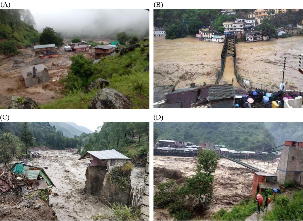
On the night of 13th and 14th August 2019, several incidences occurred in the Mori block of the Uttarkashi district. The Tons River flew over the danger mark (Figure 5 B and D). Due to this incident, 19 people were killed, nine were missing, and 47000 people of the 50 villages were affected. A heavy loss of property took place and a large portion of agricultural land was washed away. On August 17, 2019, five people died and a crasher machine was drowned due to debris flow in the Sanel village. Another big disaster of flash flood/debris flow occurred in Arakot market, Mori block, which has caused the killing of 11 people, missing seven and injuring seven people (Figure 5 A and C).
Table 2: Debris flows/flash floods in several places of the Uttarkashi district
Paligarh tributary in Yamunotri, Uttarkashi on July 7, 2019 Nil
Machines were drowned, a big portion of road was washed away and forestland damaged
Modiyatra forests in Purola on August 8, 2019 About 250 lambs were drowned A portion of forestland was damaged
Nandgaon, Pathargarh in Purola on August 8, 2019 Nil
Arakot market, Bangaan and Mori in the Tones River on August 14, 2019
About 19 people have died and nine were missing, About 47000 people of 50 villages were affected
Agricultural land was washed away and existing crops were damaged
Heavy losses of property and agricultural land took place Among them, 16 shops were damaged.
Sanel village Uttarkashi on August 17, 2019 Total of five people died A crusher machine drowned and forest land degraded
Arakot in Mori block of Uttarkashi on August 18, 2019 About 11 people were died 10 people injured and seven were missing
Source: Primary data collection in July, August, and September 2019
Agricultural land was washed away and existing crops were damaged
ISSN 2348-1218 (print)
International Journal of Interdisciplinary Research and Innovations ISSN 2348-1226 (online)
Vol. 8, Issue 2, pp: (8-16), Month: April - June 2020, Available at: www.researchpublish.com
During the study period, a number of debris flows and flash floods events occurred in other districts of the Garhwal region (Table 3). On July 4, 2019, debris flow event occurred in the Mandoli perennial stream, which has affected the Chamsheel village of Augustyamuni block. About 60 m motor road and agricultural fields were washed away and the water supply line was damaged. It has led to future catastrophes. On August 8, 2019, flash floods occurred in Nelchami perennial stream and affected Tharti village of Ghansali block, Rudraprayag district. Many houses were damaged and a transformer and eight poles were drowned. On the same day, the flash flood occurred in the Kuledi village of Kirtinagar block in the Tehri district. The two horses died and a bridge was collapsed. On August 18, 2019, debris flows and flash floods occurred in three places – Gaurikund in the Rudraprayag district, Ralakot and Chiarbari villages of Pratapnagar block in Tehri district and Kumbhichuad and Rampur areas of Kotdwar in Pauri district. Three bridges were collapsed, two shops and seven villages were damaged and a vast agricultural land was washed away.
Affected villages/River basin/Date Loss of life
Chamsheel village in Augustyamuni block, Mandoli perennial stream, Rudraprayag district on July 4, 2019
Tharti village in Ghansali block, Nelchami perennial stream, Rudraprayag district on August 8, 2019
Nil
Total of two people died
of property
About 60 m motor road was washed away, the water supply line was damaged and agricultural fields were washed away. It has already led to the future catastrophes
Many houses were damaged, a transformer and eight poles were drowned
ISSN 2348-1218 (print)
International Journal of Interdisciplinary Research and Innovations ISSN 2348-1226 (online)
Vol. 8, Issue 2, pp: (8-16), Month: April - June 2020, Available at: www.researchpublish.com
Kuledi village of Kirtinagar block in Tehri district on August 8, 2019
A total of two horses died.
Gaurikund in Rudraprayag district on August 18, 2019 Nil
Ralakot and Chirabari villages of Pratap Nagar in Tehri district on August 18, 2019
Nil
Kumbhichuad and Rampur (Jamun Srot), Kotdwar on September 6, 2019 Nil
Source: Primary data collection in July, August, and September 2019
A bridge was collapsed
Three bridges were collapsed
Four houses were damaged and two shops were collapsed
Several houses were damaged and agricultural land was washed away
There were many other streams where cloudburst triggered debris flows and flash floods occurred. Among them the Kalp Ganga and in the Ghudsal Gadhera Gopeshwar, the Khoh and Sukharo Nadi (streams) in Kotdwar, Urgam valley in Joshimath, and the Bhaitoli Nala in New Tehri are the major affected streams. On August 18, 2019, the entire Garhwal region was affected by flash floods and debris flows. Lambagarh in Joshimath and Nauli-Bagoli villages were also affected by cloudbursts-triggered landslide in the month of August 2019
The Garhwal Himalaya of the ICHR has been the worst affected region due to cloudburst triggered debris flows and flash floods since time immemorial. Other major weather-induced disasters, which are active in this region, are landslides and mass movements. Due to the occurrences of these events, the entire region received a huge loss of lives and properties. Flash floods of 2013, which is also called as ‘the Himalayan Tsunami’ and which occurred in the entire Garhwal region, mainly the Kedarnath and Badrinath valleys was the major disaster events in the region. This event has led to the death of more than 10000 people and a huge loss to property and infrastructural facilities [15] In 2018, there were a total of 4330 incidences of cloudbursts, which caused to death of 101 people, 53 people were injured and 739 houses were damaged. Likewise, the entire Garhwal region is being affected by these incidences on the year to year basis.
This study revealed that within three months of monsoon season – July, August, and September 2019, more than 112 incidences of flash floods and debris flows were occurred, which were resulted in the death of more than 45 people, about 16 people were missing, 10 people were injured, and 310 animals, including horses, lambs, cows, and oxen, were died. In a nutshell, about 47000 people above 50 villages were affected due to these events during the study period. In addition, more than 12 ha of agricultural land were washed away. About 34 houses, 22 shops, seven bridged, four machines, a transformer, and four electric poles were washed away. The existing crops were damaged and a big forest area was washed away.
The amount of rainfall determines the intensity and frequency of cloudbursts and its triggered debris flow and flash floods. The Garhwal region is witnessed that whenever the amount of rainfall was high, cloudbursts related incidences were also high. However, the temporal and spatial variation of these incidences was observed high mainly due to climate variability and change. The cloudbursts related events are more localized and their intensity is also high. It has been noticed from the study that the incidences of cloudburst triggered debris flows and flash floods have been increasing in the Garhwal region from the recent past. Although 32% rainfall deficit was registered in 2019 in the Garhwal region, yet rainfall intensity was higher in several areas where cloudburst took place. However, in 2018, total rainfall occurred in the three months of monsoon was 1229 mm. So, it is evident from the fact that despite the overall rainfall deficit in the region, cloudburst events were enormous. The landscape of the Garhwal region is one of the most fragile landscapes. Heavy rainfall disintegrates the fragile landscape. And therefore, the entire region is vulnerable to natural disasters.
The two districts of the Garhwal region – Chamoli and Uttarkashi are mountainous where the altitude ranges more than 7000 m. Slopes are steep and precipitous and the velocity and volume of the rivers/streams are very high. Further, during the monsoon season, they are more violent. The rivers are in their young stage and several times they flow above danger marks. Human and animal habitats are located along the river valleys and on the steep and precipitous slopes. All these factors accelerate the intensity of disasters. Cloudburst is a natural hazard, no one can stop it. However, cloudburst triggered disasters can be minimized. It is suggested that the slope suitability analysis should be conducted before constructing settlements and infrastructural facilities. Construction of settlements along the river valleys and on the steep and fragile slopes should be avoided. The construction of roads should also be avoided along the fragile slopes and instead of it, bridges and tunnels should be constructed.
ISSN 2348-1218 (print) International Journal of Interdisciplinary Research and Innovations ISSN 2348-1226 (online) Vol. 8, Issue 2, pp: (8-16), Month: April - June 2020, Available at: www.researchpublish.com
[1] Bandyopadhyay J, Gyawali D (1994) Himalayan water resources: ecological and political aspects of management. Mountain Research and Development, 1994, 14 (1): 1-24
[2] Bhandari RK (1994) Landslide Hazard Mapping in Sri Lanka - a Holistic Approach. Proceeding of National Symposium on Landslides in Sri Lanka, pp: 271- 284
[3] Chalise SR and Khanal NR (2001) An introduction to climate, hydrology and landslide hazards in the Hindu KushHimalayan Region. In Tianchi, L; Chalise, SR; Upreti, B.N. (eds) Landslide Hazard Mitigation in the Hindu KushHimalayas, Kathmandu: ICIMOD, pp. 51-62.
[4] Du MY, Kawashima S, Yonemura S, Zhang X Z and Chen SB (2004) Mutual influence between human activities and climate change in the Tibetan plateau during recent years. Global and Planetary Change, 41: 241-249
[5] ICIMOD (2007) Flash Flood Hotspot mapping in the Hindu Kush-Himalayan region (draft DVD ROM). Kathmandu: ICIMOD.
[6] ICIMOD (2007) Inventory of Glaciers, Glacial Lakes and Identification of Potential Glacial Lake Outburst Flood (GLOFs) Affected by Global Warming in the Mountains of the Himalayan Region (DVD ROM).Kathmandu: ICIMOD.
[7] Ives JD and Messerli B (1989) The Himalayan Dilemma: Reconciling Development and Conservation. London: John Wiley and Sons.
[8] Kumar K, Subramanya P and Kanuijia VK (2006) Geological &Geotechnical Investigations of Patalganga Landslide adjacent to NH-58, Garhwal, Uttaranchal – A Case Study, Proceedings of Indian Geotechnical Conference, Chennai.
[9] Sati VP (2013) Disaster Management and Risk Reduction, Aavishkar Publications, Jaipur.
[10] Sati VP (2013) Extreme Weather-Related Disasters: A Case Study of Two Flashfloods Hit Areas of Badrinath and Kedarnath Valleys, Uttarakhand Himalaya, India, Journal of Earth Science and Engineering, Vol 3, Pp. 562-568
[11] Sati VP (2011) Climate Disasters in the Himalaya: Risk and Vulnerability, International Conference on Climate Change and Natural Hazards in mountain Areas, Dushanbe Sept. 19-21, 2011.
[12] Sati VP (2008) Natural Resources Management and sustainable development in the Pindar Basin, Himalaya, Dehradun, Bishen Singh Mahendra Pal Singh.
[13] Sati VP and Maikhuri RK (1992) Cloudburst- A Natural Calamity. Him Prayavaran Newsletter, pp 11-13.
[14] Solomon S, Qin D, Manning M, Chen Z, Marquis M, Averyt KB, Tignor M and Miller HL (2007) Climate Change 2007: The Physical Science Basis. Contribution of Working Group I to the Fourth Assessment Report of the Intergovernmental Panel on Climate Change.Cambridge and New York: Cambridge University Press.
[15] Uttarakhand (2017) Retreat from http://www.q8india.com/blog/2017/08/15/uttarakhand cloudburst