
rbano MISCELÁNEA MISCELLANEOUS MAYO 2022 / NÚMERO 45 ISSN IMPRESA: 0717 - 3997 ISSN ELECTRÓNICA: 0718 - 3607 45

MAYO 2022 / NÚMERO 45
ISSN IMPRESA: 0717 - 3997
ISSN ELECTRÓNICA: 0718 - 3607
REVISTA DEL DEPARTAMENTO DE PLANIFICACIÓN Y DISEÑO URBANO / UNIVERSIDAD DEL BÍO - BÍO / CONCEPCIÓN / CHILE
EDITORA RESPONSABLE / Editor in Chief


ANA ZAZO MORATALLA / Departamento de Planificación y Diseño Urbano, Facultad de Arquitectura, Construcción y Diseño, Universidad del Bío - Bío. azazo@ubiobio.cl
COMITÉ DE REDACCIÓN / Editorial board

SERGIO BAERISWYL RADA / Departamento de Planificación y Diseño Urbano, Facultad de Arquitectura, Construcción y Diseño, Universidad del Bío - Bío.
IGNACIO BISBAL GRANDAL / Departamento de Planificación y Diseño Urbano, Facultad de Arquitectura, Construcción y Diseño, Universidad del Bío - Bío.
IVÁN CARTES SIADE / Departamento de Planificación y Diseño Urbano, Facultad de Arquitectura, Construcción y Diseño, Universidad del Bío - Bío.
HÉCTOR GAETE FERES / Departamento de Planificación y Diseño Urbano, Facultad de Arquitectura, Construcción y Diseño, Universidad del Bío - Bío.
MARÍA ISABEL LÓPEZ MEZA / Departamento de Planificación y Diseño Urbano, Facultad de Arquitectura, Construcción y Diseño, Universidad del Bío - Bío.
AARÓN NAPADENSKY PASTENE / Departamento de Planificación y Diseño Urbano, Facultad de Arquitectura, Construcción y Diseño, Universidad del Bío - Bío.
FRANCISCO NUÑEZ CERDA / Departamento de Planificación y Diseño Urbano, Facultad de Arquitectura, Construcción y Diseño, Universidad del Bío - Bío.
ALFREDO PALACIOS BARRA / Departamento de Planificación y Diseño Urbano, Facultad de Arquitectura, Construcción y Diseño, Universidad del Bío - Bío.
FRANCISCO SABATINI DOWNEY / Departamento de Planificación y Diseño Urbano, Facultad de Arquitectura, Construcción y Diseño, Universidad del Bío - Bío.

COORDINACIÓN EDITORIAL/assistant editor JOCELYN VIDAL RAMOS / Facultad de Arquitectura, Construcción y Diseño, Universidad del Bío - Bío. javidal@ubiobio.cl
ASISTENTE EDITORIAL/editorial assistant MARÍA PAZ CID ALARCÓN / Facultad de Arquitectura, Construcción y Diseño, Universidad del Bío-Bío mpcid@ubiobio.cl
COMITÉ CIENTÍFICO EDITORIAL/editorial board PABLO ALLARD SERRANO. Universidad del Desarrollo. Chile. ARTURO ORELLANA OSSANDON. Pontificia Universidad Católica de Chile. Chile. MABEL ALARCÓN RODRÍGUEZ. Universidad de Concepción. Chile. JORGE INZULZA CONTARDO. Universidad de Chile. Chile. ELISA CORDERO JAHR. Universidad Austral de Chile. Chile
ROBERTO GOYCOOLEA PRADO. Universidad de Alcalá. España ZAIDA MUXÍ MARTÍNEZ. Universidad Politécnica de Catalunya. España. ESTER HIGUERAS GARCÍA. Universidad Politécnica de Madrid. España. ALFREDO ANDIA STELZER. Florida International University. EEUU. CLARA IRAZÁBAL ZURITA. University of Missouri. EEUU. DANIEL GONZÁLEZ ROMERO. Universidad de Guadalajara. México. EDUARDO SOUSA GONZÁLEZ. Universidad Autónoma de Nueva León. México. HELGA VON BREYMANN MIRANDA. Universidad de Costa Rica. Costa Rica. SAMUEL VÉLEZ GONZÁLEZ. Universidad Pontificia Bolivariana de Medellín. Colombia KARINA BORJA. Universidad Católica Ecuador. Ecuador. ALICIA NOVICK. Universidad Nacional de General Sarmiento. Argentina.
DIRECCIÓN DE ARTE Y DIAGRAMACIÓN/ art director and layout IGNACIO A. SÁEZ ARANEDA ignaciosaezaraneda@gmail.com
TRADUCCIÓN AL INGLÉS/English translation KEVIN WRIGHT
CORRECCIÓN DE ESTILO/proofreader
OLGA OSTRIA REINOSO GESTIÓN WEB/webmaster KARINA LEIVA
SECRETARÍA/administration PAMELA SIERRA VILLALOBOS


IMAGEN DE PORTADA/cover image
VISTA ÁEREA NONGUÉN, COLLAO. FUENTE: PEPE LENIZ, 2022

INDEXACIONES/indexation Scopus, Scielo, Emerging Sources Citation Index, Redalyc, ERIHPLUS, DOAJ, EBSCO, AVERY Index, Latindex Catálogo 2.0, Dialnet, REDIB, REBIUN. URBANO forma parte de ARLA, Asociación de Revistas Latinoamericanas de Arquitectura.


 DEPARTAMENTO DE PLANIFICACIÓN Y DISEÑO URBANO
IMPACTOS DEL CORREDOR MIGRATORIO EN CIUDADES DE PERÚ Y CHILE: TRANSFORMACIONES URBANAS DURANTE LA PANDEMIA IMPACTS OF THE IMMIGRATION CORRIDOR ON PERUVIAN AND CHILEAN CITIES: URBAN TRANSFORMATIONS DURING THE PANDEMIC
CRISIS SOCIOPOLÍTICA, PANDEMIA Y VIVIENDA PRECARIA: ¿ARRAIGO HAITIANO EN SANTIAGO DE CHILE? (2019-2021) SOCIO-POLITICAL CRISIS, PANDEMIC, AND PRECARIOUS HOUSING: HAITIAN TIES IN SANTIAGO DE CHILE? (2019-2021)
EL ROL CONDICIONANTE DEL ESPACIO URBANO EN POSADAS, ARGENTINA SETTLEMENTS AND HABITAT. THE CONDITIONING ROLE OF URBAN SPACE IN POSADAS, ARGENTINA.
METROPOLIZACIÓN Y TURISMO EN CIUDADES INTERMEDIAS ANÁLISIS DE LA COMPETITIVIDAD TERRITORIAL DEL TURISMO EN BELLO, COLOMBIA METROPOLIZATION AND TOURISM IN INTERMEDIATE CITIES: ANALYSIS OF THE TERRITORIAL COMPETITIVENESS OF TOURISM IN BELLO, COLOMBIA
POLÍTICA DE SUELO URBANO EN SAN CARLOS DE BARILOCHE (2001-2019) APORTES PARA UN BALANCE CRÍTICO URBAN LAND POLICY IN SAN CARLOS DE BARILOCHE (2001-2019) CONTRIBUTIONS FOR A CRITICAL BALANCE.
LA SOSTENIBILIDAD DEL PATRIMONIO URBANO ESTUDIO DE CASO EN ALTEA Y LA VILA JOIOSA (ALICANTE, ESPAÑA) SUSTAINABILITY OF URBAN HERITAGE CASE STUDY IN ALTEA AND LA VILA JOIOSA (ALICANTE, SPAIN)
LA EVOLUCIÓN DE LAS ESTACIONES DE TREN ACCESIBLES EN MADRID APROXIMACIÓN A TRAVÉS DEL ESTUDIO DE MAPAS (2009-2020) THE EVOLUTION OF ACCESSIBLE TRAIN STATIONS IN MADRID: A MAP STUDY APPROACH (2009-2020)
ANÁLISIS DE ESTRUCTURAS URBANAS EN UN COMPANY TOWN INICIO, DESARROLLO Y DECLIVE DEL CASO “CAMPAMENTO NUEVO”, CHUQUICAMATA ANALYSIS OF URBAN STRUCTURES IN A COMPANY TOWN. BEGINNING, DEVELOPMENT, AND DECLINE OF THE “NEW CAMP” CASE, CHUQUICAMATA
CAMINANDO POR EL BARRIO. COMPRENDIENDO LAS EXPERIENCIAS DE LAS PERSONAS MAYORES EN UN SANTIAGO ADVERSO, EN TIEMPOS DE PANDEMIA WALKING THROUGH THE NEIGHBORHOOD: UNDERSTANDING SENIORS’ EXPERIENCES DURING THE PANDEMIC, IN A HARSHER SANTIAGO
Alberto Prado Díaz Stella Schroeder Claudio Cortés Aros
Elkin Muñoz
Alexandra López Martínez Yunier Sarmiento Ramírez
Tomás Guevara Julieta Wallace
Ángela Reos-Llinares
Sergio García-Doménech Carlos L. Marcos
Alba Ramírez Saiz
Miguel Ángel Ajuriaguerra Escudero

Editorial ANA ZAZO MORATALLA 1
What role should Chilean State Universities play in their territories? The social uprising, Covid-19, along with natural disasters like the 2010 earthquake, remind us that global phenomena have serious repercussions on the local sphere and that it is on this scale where security and resilience to change need to be generated to overcome major catastrophes, to face the challenges of our cities, and to provide local endogenous development and quality of life for those living there.
Specifically, the Law on State Universities, 21.094 of 2018, reminds us that these institutions must contribute to the sustainable development of the country and the progress of society in the diverse areas of knowledge and culture. This law put on the table several challenges for the comprehensive transformation of Chilean universities. Among them, is that of strengthening their role as generators of knowledge and human capital, to contribute to the local development of their territories from the perspective of sustainability. This challenge implies rethinking, first, what the current society, with whom we have to jointly generate the transformations, is like, and second, what the local and nationwide challenges to target are, always from a sustainability approach.
The paradigm of knowledge society, which changes from focusing on the production of material goods to focusing on the production, acquisition, and exchange of new knowledge, emerges at the end of the 20th century. This new society demands that universities, as generators of knowledge and human capital, play a more relevant role in the transformation and local development processes of the territories where they are based. The territory thus ceases to be a physical support to become an active agent with which to interact. On one hand, it receives the knowledge generated internally, serving as a real laboratory. On the other, it gives feedback on the classic missions of the university, namely teaching and research. The result is the territorialization of universities at a local level and the extension of their activities beyond their university spaces.
In this context, the third mission of the university appears, which aims to apply, use, and exploit knowledge generated by the university to increase social welfare and contribute to the social and economic development of the territory. This third mission, materialized in Chile in the three areas of technology transfer, outreach, and engagement with the environment, is called knowledge transfer in the specialized literature and articulates global thinking in the local sphere. In this way, it covers multiple dimensions - technological, social, and cultural - and involves interaction and consensus with the different actors of the territory. Its orientation can target the generation of companies, from a utilitarian perspective, or be more oriented to social responsibility, from a humanistic perspective. A committed university is one that incorporates the problems of society into the university agenda in an interdisciplinary way and takes these on as a challenge, contributing to local development and the generation of public policies through knowledge.
EDITORIAL ANA ZAZO MORATALLA REVISTA URBANO Nº 45 / MAYO 2022-OCTUBRE 2022 PÁG. 47 ISSN 07173997 / 07183607
1 2
Editora Revista Urbano Doctora Arquitecta en Sostenibilidad Urbana Académica del Departamento de Planificación y Diseño Urbano, Facultad de Arquitectura, Construcción y Diseño Universidad del Bío Bío http://orcid.org/0000-0003-1912-9448 azazo@ubiobio.cl
This text contextualizes to the Chilean reality the theoretical contributions of the PhD thesis: Arcos, Maribel (2019) Universidad, Territorio y Desarrollo Local. Un análisis de la Universidad Autónoma de Barcelona, Barcelona: Universitat Autónoma de Barcelona.
DOI: https://doi.org/10.22320/07183607.2022.25.45.00
Figura 1, 2 Vista áerea Nonguén, Collao. Fuente: Pepe Leniz, 2022
This third mission must strengthen its relational dimension with the territory by generating links with all the actors that are part of the local transformation and dynamization through the quadruple helix model. In this model, the university, as a generator of knowledge and human and intellectual capital, must reach out to the citizenry, as a beneficiary but also a producer of knowledge; to the public administration, as a creator of regulatory frameworks and public policies; to the local productive sectors, as potential recipients of innovation, but also as potential financiers of research. In short, this relational model should form a collaborative governance whose purpose is to analyze, anticipate, and cooperate in the management of the future territory project.
The crux of the question is what should the approach be for the university to enhance this bidirectional relationship with the territory. In the current context, marked by the climate, environmental, and energy crisis, it is inescapable that sustainability is the direction that guides teaching, research, and its transfer to the territory. The goals set by the UN on a global scale, such as the Millennium Development Goals or the New Urban Agenda for 2030, are the frameworks that universities must adopt to respond to local-scale challenges.
For some decades now, European and American universities have begun to incorporate sustainability as an overriding dimension in their daily work, from its integration into teaching and research, the management of their campuses, and the internal culture, to the definition of their relationship with the territory. Diverse methodologies have been created in each geographical setting to guide their transition, evaluate the implementation, provide green stamps and seals, and classify them based on their sustainability criteria. In the Latin American sphere, there is an evaluation tool called RIES, developed by the Sustainable Campus Network, which aims to act both as a roadmap to facilitate the transition of Ibero-American Higher Education institutions, and as a methodology for evaluating the performance of sustainability policies. It has five categories, including governance, sustainable culture, academia, campus management, and engagement with the environment. This last category analyzes the efforts made by universities to contribute to generating a fairer, more equitable, more diverse, and gender-sensitive society inside and outside the university.
From the perspective of the institutionalization of sustainability, this must not only be integrated in a transversal way in each state university, but it must permeate the entire national university system in an integral way. This implies that it needs to be promoted from higher institutionalized settings so that they have a bottom-up influence on public policies, and a top-down one on the real transition of its group of universities through different formulas such as evaluation, seals, or rankings. In Spain, the Conference of the Rectors of Spanish Universities (CRUE) has been working since 2007 on the dimension of university sustainability, evaluating the level of contribution to the environmental sustainability of Spanish universities to know their strengths and weaknesses and to guide university policies. However, in Chile, today it is a private association, the Sustainable Campus Network, whose affiliation is voluntary, which brings together the debate and discussion on sustainability at the university level, being completely independent of the Council of Rectors of Chilean Universities (CRUCH) and the State Universities Consortium (CUECH), which are the current space of discussion and proposals on the quality of Chilean university teaching and performance.
Therefore, it is essential to outline a radical transformation of the Chilean university system which, freed from the bureaucratic constraints and ideologies imposed by the neoliberal system, assumes sustainability as its flag, and promotes its transversal integration not only internally, but especially outside its buildings and campuses, aiming to solve urban challenges, to strengthen the sustainable development of its territory, and to advance the quality of life of the people living there.

IMPACTOS DEL CORREDOR MIGRATORIO EN CIUDADES DE PERÚ Y CHILE: TRANSFORMACIONES URBANAS DURANTE LA PANDEMIA
ALBERTO PRADO DÍAZ, STELLA SCHROEDER, CLAUDIO CORTÉS AROS REVISTA URBANO Nº 45 / MAYO 2022-OCTUBRE 2022 PÁG. 819 ISSN 07173997 / 07183607
Recibido: 01-12-2021 Aceptado: 15-05-2022
URBAN TRANSFORMATIONS DURING THE PANDEMIC
IMPACTOS DEL CORREDOR MIGRATORIO EN CIUDADES DE PERÚ Y CHILE TRANSFORMACIONES URBANAS DURANTE LA PANDEMIA
ALBERTO PRADO DÍAZ 1 STELLA SCHROEDER 2 CLAUDIO CORTÉS AROS 3
Doctor en Arquitectura
Universidad Arturo Prat, Facultad de Ingeniería y Arquitectura, Iquique, Chile. Académico e Investigador vinculado a la Escuela de Arquitectura y a la Facultad de Ingeniería https://orcid.org/0000-0002-6392-0694 alprado@unap.cl
Magíster en Ciencias (Urbanismo)
Universidad de Piura, Facultad de Ingeniería, Piura, Perú. Directora del Instituto de Urbanismo y Territoriales. Escuela de Arquitectura. https://orcid.org/0000-0001-8591-2719 stella.schroeder@udep.edu.pe
Magíster en Antropología y Desarrollo
Universidad de Antofagasta, Instituto de Investigaciones Antropológicas, Antofagasta, Chile. Académico e Investigador del Instituto de Investigaciones Antropológicas. https://orcid.org/0000-0002-7015-2590 claudio.cortes@uantof.cl
9
El desalojo de migrantes de la plaza Brasil, en la ciudad de Iquique, cuestionable por la violencia de la fuerza pública, dejó de manifiesto no solo el problema humanitario implicado, sino también un punto de inflexión en los intentos por normalizar un proceso donde las ciudades se han visto alteradas por el éxodo de migrantes. El presente estudio indaga en los impactos generados por las sucesivas etapas de migración correspondientes al flujo migratorio venezolano, el cual se caracteriza por una condición de gran vulnerabilidad. Desde inicios de 2020, en etapa de crisis sanitaria y cierre de fronteras, estos migrantes han ingresado por vía terrestre y por pasos no habilitados a Colombia, Ecuador, Perú, Bolivia y Chile, con el propósito de encontrar mejores condiciones de vida en los destinos prioritarios en este contexto. Se discuten aquí los enfoques que relacionan flujos y transformaciones como respuestas a factores de reproducción de la sociedad global, con aquellos que conciben la movilidad como una “fuerza creativa” que interactúa en forma autónoma con estas estructuras. Para ello, se explora la movilidad en los centros históricos de tres ciudades ubicadas en zonas de tránsito fronterizo y de ingreso a cada país, donde la interrelación en el espacio público se ha transformado y tensionado: Piura, en Perú, e Iquique y Antofagasta en Chile. Los resultados evidencian similitudes en dinámicas y transformaciones generadas. Dada la condición vulnerable de los migrantes, se observa un incremento en la ocupación del espacio público como resultado de acciones autónomas de autogestión y organización, como también de resistencia local, lo que da cuenta de la relevancia de la movilidad en la sociedad contemporánea. Se recomienda, en suma, adoptar una agenda diferenciada para comprender la conexión entre migrantes y lugares durante la experiencia de movilidad.
Palabras clave: migración, covid-19, espacios públicos, transformaciones urbanas.
The eviction of migrants from Plaza Brasil, in the city of Iquique, an act that was questioned due to the violence used by public forces, revealed not just the humanitarian problem involved, but also a turning point in attempts to normalize a process where cities have been altered by the exodus of migrants. This study looks into the impacts generated by the successive stages of migration within the Venezuelan migratory flow, one characterized by the great vulnerability of these migrants. Since the start of 2020, amid a health crisis and border closures, they have entered Colombia, Ecuador, Peru, Bolivia, and Chile by land using unauthorized crossings, to find better living conditions in these destinations. Here, the approaches which connect flows and transformations as responses to reproduction factors of global society, with those that conceive mobility as a “creative force” that interacts autonomously with these structures, are discussed. To this end, mobility in the historical centers of three cities located in border transit and entry zones to each country, where the interrelation in public space has been transformed and stressed, is explored, namely Piura, in Peru, and Iquique and Antofagasta in Chile. The results show similarities in the dynamics and transformations generated. Given the vulnerable condition of migrants, there is an increase in the occupation of public space, through autonomous actions of self-management and organization, as well as local resistance, demonstrating the relevance of mobility in modern society. All-in-all, it is recommended to adopt a differentiated agenda to understand the connection between migrants and places during the mobility experience.
IMPACTOS DEL CORREDOR MIGRATORIO EN CIUDADES DE PERÚ Y CHILE: TRANSFORMACIONES URBANAS DURANTE LA PANDEMIA ALBERTO PRADO DÍAZ, STELLA SCHROEDER, CLAUDIO CORTÉS AROS REVISTA URBANO Nº 45 / MAYO 2022-OCTUBRE 2022 PÁG. 819 ISSN 07173997 / 07183607
Keywords: migration, covid-19, public spaces, urban transformations.
In Latin America, the social, political, and economic crisis in Venezuela has caused the largest population exodus of the last two decades towards the south of the continent. Migratory movements have become a challenge, especially for recipient countries; a situation that has worsened amid the Covid-19 pandemic, increasing the health crisis, and requiring immediate responses from the affected governments. In this process, cities have played a substantial role, as crossroads, especially those located on the Pacific Ocean, where more than four million Venezuelans have made their way along the geographical corridor towards the tip of America.
Peru and Chile have been experiencing constant economic growth, as have Colombia and Ecuador, which alongside geographical continuity factors have made them attractive destinations for migrants. According to the Venezuelan Population Flow Monitoring in Peru, made by the International Organization for Migration (IOM) (2020), in February 2020, the Venezuelan population in transit indicated Peru as their main final destination (92.6%), followed by Chile (5.3%), Argentina (1.2%), and Bolivia (0.6%). In Peru, 860,000 Venezuelans have found refuge, and in Chile, 361,000 (Escobar, 2019); figures that consolidate their role as recipient countries of cross-border migration, and that force their cities to adapt.
The cities located on the migratory corridor, in border transit and entry zones to each country, on the route to the priority migration regions and cities, such as Lima and Santiago, are the main destination cities for migration. These play the role of receiving migrants and represent attractive employment options. In the northern region of Peru, service, agro-export, and extraction activities lead the economy, positioning themselves as a labor alternative for migrants. The cities of northern Chile are attractive to migrants due to mining, services, and trade in the Duty-Free Zone, the result of their ability to continue leading the economic dynamism. Thus, as border cities, Piura, in Peru, and Iquique and Antofagasta, in Chile, have a double role, of transit and of receiving migrants.
In this evolution, these cities have been transformed in terms of the occupation and reconfiguration of public space, integrating the migrant movements. From the growth of street trade and informal settlements in the outskirts, migrants contribute with new lifestyles and add a component of social unrest today. Above all, the lack of adequate responses from local governments, stresses the social reality of cities, especially for those
which this study addresses, exacerbating the extreme positions that question the arrival of migrants.
The prominence of space in the creation of the migrant mobility social reality and its articulation with the reproduction processes of global society (Santos, 2004; Canales, 2016; Maldonado, Martínez Pizarro, and Martínez, 2018), are under debate. On one hand, some find the movement, permanence, and resettlement of the migrant population, as responses to the dynamic transformation of contemporary society conditioned by capital, demography, class structure, and social inequality reproduction factors (Canales, 2013). On the other, some see this phenomenon as a “creative” force to address the basic needs of survival (Casas-Cortes, 2020). For Bojadzijev and Serhat (2010), this is an autonomous response of migration, in the configuration of mobility in space, which emerges from social conflicts, and leads to rethinking the approaches to analyze the South American migration route.
In this context, the purpose of this research is to contribute to debates on relationships between space and its users, examining the interrelation between migrants and public space through their daily use in the historic center of the three South American cities. It seeks to understand the specificities of the relationship between this group of users and the public space, identifying survival tactics as well as those of resistance and organization, and comparing the urban dynamics and transformations in the heart of the three cities.
Based on theoretical discussions on the precariousness of temporary migration and the intersection between migrants and urban space, the proposal of the work seeks to expand upon the reflection on the incidence of migration dynamics in the reconfiguration of cities, which presupposes, in a globalized world, pondering the migrant as an active driver of urban restructuring (Bork-Huffer, 2009). et al., 2014; Maldonado et al., 2018).
Migration is built in a complex, multi-variable scenario, exacerbated by the health crisis that exceeds humanitarian borders in a framework that the process of globalization grants. To date, several investigations address the effects of migration processes and how they, as socio-spatial dynamics, have marked the development of cities, the use of public space, urban expansion processes, policies, and the local economy (Etzold, 2019). Likewise, some evaluate the global dimension of the territorial transformations that are affecting
South American countries, as responses to global society reproduction factors (Santos; 2004; Canales, 2013; 2016; Maldonado, 2018).
In the context of the political and socio-economic crisis in Venezuela, added to the health emergency and migratory restrictions imposed by South American governments, the movements of the Venezuelan migratory flow found permeable points on the borders of Colombia, Ecuador, Peru, Bolivia, and Chile. This allowed shaping the migration corridor (Figure 1), as a concrete experience enhanced by the geographical continuity and the experiences that pioneer migrants shared through social networks, which allow understanding systemic relations and their connections, encouraging the population exodus, and increasing the number of people entering irregularly or informally.

Initially, on a South American scale, the economic and social crisis in Venezuela and Colombia (during the early 2000s) triggered migration to Peru and Chile, which positioned themselves as receiving countries for migrants (IOM, 2020). On a national scale, as part of the geographical migratory corridor, Peru and Chile are both transit countries and recipients of migratory flows, and, on a local scale, their strategic cities are a crossroads.
The proposal of Datta and Brickell (2011) falls within the scope of city space transformation. It allows observing and interacting with the different migrant dynamics and reveals an understanding of the broadly and spatially complex mobility, regarding the modification and adaptation processes of places, of a groundedness during those interactions. The translocal approach embodies not only studying local-global relations but, at the same time, local dynamics. The urban transformations as trans-local reconfigurations, resulting from those social practices, which create and transform shapes (Santos, 1996), and as significant ways that materialize human existence, where there is no human being who does not rise within a world of humanized materialities (Silveira, 2014), constitute statements that simultaneously allow recovering and unveiling the social totality, in other words, the space as a whole.
In this framework, the public spaces as stages for dispute, and the complex and conflicting encounters of different actors, show the various forms of appropriation of an active citizenry (García-Arias and Hernández-Pilgarín, 2019) and, in parallel, can play a key role in improving migrant inclusion by acting as places for dialog and intercultural exchange (Price and Chacko, 2012). Likewise, Kohn (2004) identifies three components of public space: ownership, accessibility, and intersubjectivity. He relates property to public goods; accessibility to the possibility of entry to all inhabitants; and intersubjectivity to the social aspect and the promotion of communication and interaction. The study of public space gains depth by adopting a more people-centered approach and its fundamental role in the social and economic life of communities. In this sense, Borja and Muxí (2003), Johnson and Glover (2013), and Wittmer (2017) have realized their importance in the city. It should be added that there are different land uses in the city and public space has the role of linking them, creating places for recreation, exchanging products, or creating symbolic landmarks (Carrión 2007).
In general, it is acknowledged that space is produced, endowed with meaning by its inhabitants and users, and is the product of complex power relations (Lefebvre, 2013; de Certau, 1999). Just as with the concept of “appropriation”, this is a result of the creative action of citizens expressed in the city space, those who are brought together and converge in its production. The design and the proposed roles of public space are, according to Lefebvre (2013), representations of space that reflect “decisions about what - and who - should be visible and what should not, [when talking about] concepts of order and disorder” (Zukin, 1995). This duality between the uses of space, in the decision-making process, and the user or users as active creators of space,
11
IMPACTOS DEL CORREDOR MIGRATORIO EN CIUDADES DE PERÚ Y CHILE: TRANSFORMACIONES URBANAS DURANTE LA PANDEMIA ALBERTO PRADO DÍAZ, STELLA SCHROEDER, CLAUDIO CORTÉS AROS REVISTA URBANO Nº 45 / MAYO 2022-OCTUBRE 2022 PÁG. 819 ISSN 07173997 / 07183607
Figure 1. Venezuelan migration corridor. Source: Preparation by the authors.IMPACTOS DEL CORREDOR MIGRATORIO EN CIUDADES DE PERÚ Y CHILE: TRANSFORMACIONES URBANAS DURANTE LA PANDEMIA ALBERTO PRADO DÍAZ, STELLA SCHROEDER, CLAUDIO CORTÉS AROS REVISTA URBANO Nº 45 / MAYO 2022-OCTUBRE 2022 PÁG. 819 ISSN 07173997 / 07183607
generates the question: who really is the user and how do they appropriate the space?
By the beginning of 2021, the measures adopted by the region’s countries sought to control the spread of the pandemic. With the declaration of a health emergency, restrictions on freedom of movement increased, and with the closure of borders, a ban on the entry of non-resident foreigners was decreed. The lockdown rulings, the crisis in hospital care, and compulsory vaccination generated a differentiated impact on the different population groups, hitting the population with limited resources and precarious and informal jobs harder. In this way, the mass arrival of migrants alongside a major part of the local population, which had to leave their homes and neighborhoods to support their families, led to different subsistence and appropriation strategies of the public space.
Given the breadth of the migratory phenomenon, this research sought to design a work methodology that would address the dynamic complexity of occupation of urban space – and its restrictions - in the chosen cities. Thus, the first decision of the team was the choice of urban centers, where the first plane of reflection went through understanding the particularities of each city, their economic activities, demographic and location aspects, among others, contextualizing Venezuelan mobility in its transit along the migratory corridor. In this way, the approach from geography, architecture, and anthropology is formed by a multidimensional vision that favors analysis of the migratory phenomenon and its interaction in the public space. Specifically, the spatial dimension – the transit through places and territories – was one of the objectives to be addressed. Hence, an observation strategy was chosen, but from a perspective that allowed dialog from a multilocalized strategy (Rivero, 2017). It sought to privilege observing movements in those points that, during the pandemic, remained a constant reference of migrant occupation, which became a space to share access to resources, accommodation, and information regarding the next stages of their “journey”.
A descriptive methodology and a qualitative approach were chosen for the research approach, (Flick, 2012), characterized by capturing and reconstructing meanings (Ruiz, 2012), since they helped expand upon the analyzed scale, comprising the movement of individuals in the context of the historical centers. Its application was based on using an observation pattern and its purpose was to identify the spatial movement of migrants in the public
space, in a pandemic context and the resulting tensions regarding the use and access to services in that space. The record was complemented with photographs, given the importance of visual data (Banks, 2010), and with the elaboration of sketches based on flow maps of people’s movement around the different streets of the city, which allowed reconstructing the plans included in the next section. Finally, the fieldwork was completed with open and brief conversations that, in many cases, emerged during the observation in a quick and the least invasive way possible so as not to greatly affect the vulnerability of migrants and their complex conditions.
The dual role of cities as a stop-off and migratory corridor effectively became a constant, where migrant practices were reproduced in different places. Through the observations made in each city, it was possible to identify several forms of occupation. The constructivist perspective, by providing analysis of the characteristics of flows and paths in the public space, helped to understand the displacement dynamics, giving meaning to the occupation of urban centers in the specific context of the pandemic and allowing, not just to discuss the particularities and generalities of the phenomenon in the three cities, but also to develop possibilities to expand upon and for the continuity of the study.
Regarding migrant visibility in the space of the three cities, a new dynamic generated by migrants, and an increase in associated economic activities can be noticed. Figures 2, 3, and 4 show the mapping of the Venezuelan community’s activities against the commercial activities of the center and its public spaces.
The city of Piura (Figure 2), is the fifth-largest city in the country, with about 480,000 inhabitants (National Institute of Statistics and Informatics [INEI], 2018). Due to its border location, it is the destination for migrants passing through the border with Ecuador and is the transit zone to other southern regions of the country. The city experienced exponential growth driven by invasions or illegal land markets. In addition, it is estimated that 90% of the population works in the informal sector, many in services and construction (INEI, 2018). In the urban structure of the historic center, the Plaza de Armas (1) and Grau Avenue and Oval (2) stand out, where there is a noticeable presence of Venezuelan refugees and migrants, with a greater concentration on Grau Avenue, one of the city’s main avenues. In its first blocks, this stands out as being an important commercial
13
IMPACTOS DEL CORREDOR MIGRATORIO EN CIUDADES DE PERÚ Y CHILE: TRANSFORMACIONES URBANAS DURANTE LA PANDEMIA ALBERTO PRADO DÍAZ, STELLA SCHROEDER, CLAUDIO CORTÉS AROS REVISTA URBANO Nº 45 / MAYO 2022-OCTUBRE 2022 PÁG. 819 ISSN 07173997 / 07183607


Figure
 Figur3 2. The historic center of Piura and urban displacement of migrants. Source: Prepared by Angie Calle.
3. The historic center of Iquique and urban displacement of migrants. Source: Preparation by the authors.
Figur3 2. The historic center of Piura and urban displacement of migrants. Source: Prepared by Angie Calle.
3. The historic center of Iquique and urban displacement of migrants. Source: Preparation by the authors.
intersection that is confirmed in the pedestrian flow, the shops, and some traditional places.
The city of Iquique and Alto Hospicio form a conurbation whose total population, according to the 2017 census, is 300,000. Iquique extends along a narrow coastal platform and its center (Figure 3) was historically configured by its relationship with the port and its activities. The arrival of groups of Venezuelans in 2020 marked a humanitarian turning point. Migrant families, enduring extreme climatic conditions, crossed the border at more than 4,000 meters above sea level, from the high planes of Bolivia and Chile, and descended towards Iquique, crossing the desert to reach the city. The historic center became a reference point to receive them. There are three squares in the historic center’s urban structure, which give an order to the city: the main square, Plaza Prat (1), with its financial and social activities, and heritage buildings of the Municipal Theater, cafes, and clubs; Plaza Condell (2), with commercial activities that extend into the surrounding streets; and, finally, Plaza Brasil (3), linked with the neighborhood urban unit that welcomed former migrants who gave it its name, “Barrio Inglés” or the “English Neighborhood”.
Meanwhile, the city of Antofagasta has been a center of cosmopolitan attraction since its foundation. With

an eminently mining origin, it was known for attracting workers and families from different corners of the world. Nowadays, with a population of over 360,000 inhabitants, according to the 2017 Census, it is the region with the highest number of copper deposits in the country, and their exploitation, in turn, has had an important effect on the urban dynamics of the region and attracts new inhabitants in a search for work. It is one of the cities with the largest migrant population in northern Chile. In the urban structure of the historic center, Paseo Prat (3) and Matta Street (7) stand out, one of the main arteries of the city, which is located near the Mall (2) (Figure 4) and has the largest flow of migrants.
Three occupation and transformation categories were observed in the three centers. Figures 5 and 6 illustrate some of the dynamics observed in the historic center of the cities of Piura and Antofagasta. The first category corresponds to formal trade, referring to established trade, and has an association with migrants linked to their vocation and identity practices. In the three cities, a new dynamic can be seen, through an increase in economic activities, with migrant-managed barbershops, services, clothing sales, and fast food joints. Through the stores, social networks are created and other businesses are established. In Piura, the formal trade of the Venezuelan migratory group is a new phenomenon over the last

five years and has intensified with the pandemic. In the two Chilean cities, but especially in Antofagasta, the first migratory wave of Colombians dates back to the 2010s, and the presence of migrants in the historical centers is common, as such it is not so easy to identify Venezuelans. In practice, they add to a participatory and integrative synergy (Massó Guijarro, 2013) associated with informal street economic activity. In the case of Iquique, the number of migrant-managed shops has increased considerably in recent years, with the arrival of the first migrants from Venezuela, alternating between street markets or strip malls.


Informal street trade is a widespread phenomenon in the three cities analyzed, something that is perceived in
a polarized way. The merchants are found in the busiest streets of the center, although in the afternoon/evening they move to spaces outside the malls or parks. Street vendors and food stalls in the streets are part of the commercial activity that gives open spaces a special character, beyond the productive work and the social connection they generate. Among the most symbolic aspects of consumption, territorial appropriation was found, where the explicit cultural expressions of migrants, associated with open spaces, such as music, food, and drink, can be considered activities of attachment to the place. They are the same sellers who come every day occupying the same places. They indicate that there is a certain organization between them and everyone knows each other. Despite the mobility restrictions of the pandemic, a high number of street vendors are seen
in the main streets of the center. In Piura, this mostly happens on Grau Avenue and its oval (2). In Iquique, commercial activities were concentrated on Tarapacá and Vivar streets, where informality predominates occupying the streets, and the presence of Venezuelan migrants is a minority. In Antofagasta, the largest concentration of informal trade is located on Matta Street (7), specifically in places with a greater influx of public, due to the control by the police.
Finally, the camp-type temporary forms of occupation, through tents and awnings, have emerged in the public space of the three historical centers, in squares, vacant lots, and green and recreational areas, as well as in beach areas. In Piura, places such as the Children’s Playground (3) or the green areas in the Los Cocos Development are occupied with tents as overnight spaces. In Antofagasta, due to the lack of space in green areas in the center, the temporary occupation has moved to the interstitial area between the Institutional and Commercial Center and the port area, and the Antofagasta Mall (2). Before the mass-scale arrival of Venezuelan migrants, it was used as a temporary settlement for the “homeless” population. Currently, there is a visible occupation in these spaces, mainly during the day. Thanks to the information gathered, it can be stated that migrant family tents are installed during the night, especially in areas around the port, since during the day these spaces have surveillance

that makes it difficult to maintain a permanent setup. While in Piura and Antofagasta the occupation has a very temporary character, in Iquique there is an appropriation of the space for a longer period, where the appropriated migrant tent area is concentrated in Plaza Brasil (Figure 7).
As a special case, the occupation of Plaza Brasil acquired a particular character due to its outcome: the violent eviction at the end of September by the police. The occupation began in September 2020 and remained active and uninterrupted as a camp for a year. The temporary appropriation evidenced a dynamic of selfmanagement and resistance as a means of pressure to obtain a response from the central government and achieve its migration projects. The form of appropriation was characterized by the organization and planning of the square’s space, into areas for families and single men, by the setup of their tents and the distribution of cooking spaces, shared dining areas, and awnings for toilets and showers. The process continued with the zoning by uses and activities, differentiated by the needs of family groups and/or single men. The appropriation was accepted by the neighbors initially when the humanitarian nature prevailed and the presence of children and women marked the process. An action, in keeping with a city that identifies itself as multicultural since its founding, where it is normal to live among migrants, with ethnic and sociocultural diversities. However, while awaiting a response
from the government, criticism and discriminatory comments were on the rise, which ended up triggering an extremely violent outcome.
The results of this research allow demonstrating the effects of migration on the spatial dimension of the three cities under study, identifying the local survival tactics employed. A spatial dynamic linked to the migrants and the ways of occupying urban space can be observed. The context, practices, and ways in which it is used to meet needs vary and are related to individual cases and circumstances. More so in Peru, a country that is known for its high rates of informality, and in the cities of the north of Chile, where these forms of employment are not new, or different from those that took place before the arrival of refugees and migrants from Venezuela.
The findings obtained should be evaluated with caution due to some methodological limitations that could compromise their external validity. In this sense, it is worth mentioning a transversal difficulty present during the pandemic: both the restrictions on the mobility of people, as well as the dimension, scope, and speed of the Venezuelan migratory process, complicated collecting information, given the impossibility of keeping permanent contact with migrants.
On the other hand, migrants, depending on their socioeconomic status and origin, but also the specific migration policies of the recipient countries, were conditioned to varying degrees, included or excluded from accessing urban institutions, infrastructures, and services. Some created and/or expanded informal spaces to secure a livelihood, housing, or education (Roy and AlSayyad, 2004). In the case of the occupation of urban spaces with tents, specifically in Iquique, the arrival of migrants poses a challenge to the established state regulation and the political systems of the receiving countries. As Bork-Huffer et al. (2014) argue, the situation of being a migrant denies opportunities to make longterm plans and decisions for work and life, since one remains in improvised, fragile, and temporary conditions. The visibility of human practice through the daily use of a massive group of migrants highlights the importance and meaning of its representation. “The very act of representing one’s group [...] before a wider audience creates a space for representation” (Mitchell, 2003), and such is the case of the three centers.
However, by adapting to the urban environment, migrants are transforming urban spaces according to
their needs, options, and restrictions. This is the case with migrant street vendors who, in the three cities, create new flexible and fluid informal spaces that fulfill fundamental social, cultural, and economic functions (Etzold, Keck, Bohle, and Zingel, 2009). Public spaces are hotbeds of public order and the activities of vendors often provoke a response from security personnel and local vendors (Bork-Huffer et al, 2014). Corroborating the prominence that the public space acquires, urban areas have a deep ambivalence, since, for many, they are both places of hope and opportunities as well as places of conflict and survival. This ambivalence shapes the interactions and negotiation of urban public spaces. From this perspective, the study shows similarities and particularities in each of the three cities, in the spatial and temporal patterns of use, as well as in the actions of local resistance to a vulnerable migrant, manifested in attempts to normalize a reality.
The purpose of this work was to contribute to debates on relationships between space and its users, examining the interrelation between migrants and the public space through their daily use in the historic centers of three South American cities: Piura, in Peru; Iquique and Antofagasta, in Chile. The presence of migration in the urban landscape contributes to questioning the use and meanings given to urban spaces. In this sense, progress was made towards understanding the specificities of the relationship between this group of users and the public space.
To conclude, it should be noted that in this study, integration is conceived as a matter of relational equality, therefore, it should promote more egalitarian relationships between people, where social networks have become very important. However, equality does not necessarily indicate integration as a situation where social boundaries are overcome. In addition, people may identify with different local or transnational groups, and personal affiliation may be stronger than national ones.
Urban citizens coexist, react, and contribute to the dynamics of urban spaces. The receiving and transit cities have been transformed through transitory dynamics, where the location of migrants has been changing over time in each city, taking the respective transnational practices with it. In this context of internal mobility, a process of adaptation, integration, and resistance is generated, which gives rise to
17
IMPACTOS DEL CORREDOR MIGRATORIO EN CIUDADES DE PERÚ Y CHILE: TRANSFORMACIONES URBANAS DURANTE LA PANDEMIA ALBERTO PRADO DÍAZ, STELLA SCHROEDER, CLAUDIO CORTÉS AROS REVISTA URBANO Nº 45 / MAYO 2022-OCTUBRE 2022 PÁG. 819 ISSN 07173997 / 07183607
socio-cultural transformations, that, in turn, will create new relationships between migrants and locals.
El Comercio (15 abril 2018). ¿Cuál es la situación de los venezolanos en las regiones? Recuperado de https://elcomercio.pe/peru/situacionvenezolanos-regiones-noticia- 511858-noticia/
Escobar La Cruz, R. (2019, June 25). Los ‘panas’ que vienen. El país. Recuperado de https://elpais.com/elpais/2019/06/24/migrados/1561370637_128671.html
The findings of this study have significant implications for understanding urban processes, contributing to the debate on dynamism in cities. Starting from the basis that public spaces promote communication, it can be argued that this potential to reconnect all parties can create new forms of coexistence, allowing social mixing, citizen participation, and a sense of belonging. There is a clear need for a deeper understanding of the dynamics in the urban space of our cities regarding migratory flows, even more so with the emergence of protests with anti-migrant and xenophobic attitudes. However, these survival tactics, as well as those of resistance and organization, can stimulate and support urban innovation, increasing the competitiveness of cities and, ultimately, contributing to their economic development.
DEL CORREDOR
EN CIUDADES DE PERÚ Y CHILE: TRANSFORMACIONES URBANAS DURANTE LA PANDEMIA ALBERTO PRADO DÍAZ, STELLA SCHROEDER, CLAUDIO CORTÉS AROS REVISTA URBANO Nº 45 / MAYO 2022-OCTUBRE 2022 PÁG. 819 ISSN 07173997 / 07183607
Banks, M. (2010). Los datos visuales en Investigación Cualitativa. Madrid: Ediciones Morata, S.L.
Bojadz ijev, M. y Serhat, K. (2010). Recuperating the Sideshows of Capitalism: The Autonomy of Migration Today. e-flux Journal, (17). Recuperado de https://www.e-flux.com/journal/17/67379/recuperating-the-sideshows-of-c apitalism-the-autonomy-of-migration-today/
Borja, J. y Muxí, Z. (2003). El espacio público, ciudad y ciudadanía Barcelona: Editorial Electa.
Bork-Huffer, T., Etzold, B., Gransow, B., Tomba, L., Sterly, H., Suka, K. y Flock, R. (2014). Agency and the Making of Transient Urban. Population, Space and Place, 22(2). DOI: https://doi.org/10.1002/psp.1890
Canales, A. (2013). La migración en la reproducción de la sociedad global. Migración y desarrollo, 11(21), 09-41. Recuperado de http://www.scielo. org.mx/scielo.php?script=sci_arttext&pid=S1870-75992013000 200002&lng=es&tlng=es.
Canales, A. (2016). La migración en la reproducción de la sociedad. Elementos para una teoría de las migraciones. En Canales, A. (Coord.), Debates contemporáneos sobre migración internacional. Una mirada desde América Latina (21-63). México: Universidad de Guadalajara.
Carrión, F. (2007). Espacio público: punto de partida para la alteridad. En Segovia, O. (Ed.), Espacios públicos y construcción social. Hacia un ejercicio de ciudadanía (pp.79-97). Santiago de Chile: Ediciones SUR.
Casas-Cortés, M. (2020). La autonomía de la migración: Una perspectiva alternativa sobre la movilidad humana y los controles migratorios. EMPIRIA. Revista de Metodología de Ciencias Sociales, (46), 65-92. DOI: empiria.46.2020.2697
Datta, A. y Brickell, K. (2011). Translocal Geographies: Spaces, Places, Connections Farnham: Ashgate.
De Certau, M. (1999). La invención de lo cotidiano. México: Universidad Iberoamericana/ITESO/Centro Francés de Estudios Mexicanos y Centroamericanos.
Etzold B., Keck M., Bohle H. G. y Zingel, W. P. (2009). Informality as agency. Negotiating food security in Dhaka. Die Erde, (140), 3–24.
Etzold, B. (2019). Migrants Turn Cities at the Crossroads into ‘Transient Urban Spaces’. Understanding the relations between migration, translocality, and urban transformations. Research Group Transient Spaces & Societies. DOI: https://doi.org/10.34834/2019.0005
Flick, U. (2012). Introducción a la investigación cualitativa. Madrid: Ediciones Morata.
García-Arias, M. F. y Hernández-Pilgarín, G. (2019). Obsolescencia y revitalización de un parque. Acción colectiva, cognición y ciudadanía en la apropiación del espacio público. Revista Eleuthera, 20, 55–72. DOI: https://doi. org/10.17151/eleu.2019.20.4.
Instituto Nacional de Estadística e Informática [INEI] (2018). Producción y Empleo Informal en el Perú. Recuperado de https://www.inei.gob.pe/media/ MenuRecursivo/publicaciones_digitales/Est/Lib1589/
Johnson, A. J. y Glover, T. D. (2013). Understanding Urban Public Space in a Leisure Context. Leisure Sciences, 35(2), 190–197. DOI: https://doi.org/10.1080 /01490400.2013.761922
Kohn, M. (2004). Brave new neighborhoods: the privatization of public space New York: Routledge.
Lefebvre, H. (2013). La producción del espacio. Madrid: Capitan Swing.
Maldonado, C., Martínez Pizarro, J., Martínez, R. (2018). Protección social y migración. Una mirada desde las vulnerabilidades a lo largo del ciclo de la migración y de la vida de las personas. Comisión Económica para América Latina y el Caribe (CEPAL). Documentos de Proyectos. Santiago: Naciones Unidas.
Massó Guijarro, E. (2013). Overcoming methodological nationalism: Cosmopolitan communities of interaction in the Lavapiés neighborhood. Migraciones Internacionales, 7(2), 71–100. DOI: https://doi.org/10.17428/rmi. v7i25.697
Mitchell, D. (2003). The Right to the City: Social Justice and the Fight for Public Space New York: The Guilford Press.
Organización Internacional para las Migraciones [OIM] (2020). Monitoreo de flujo de población venezolana en el Perú. Recuperado de https://www.unicef. org/peru/media/6361/file/DTM 7 - Datos sobre población venezolana en Perú.pdf
Price, M. y Chacko, E. (2012). Migrants’ Inclusion in Cities. Innovative Urban Policies and Practices New York: UN-Habitat y UNESCO.
Rivero, P. J. (2017). La investigación multilocalizada en los estudios migratorios transnacionales. Aportes teóricos y prácticos. Trabajo y sociedad, (28), 327–342.
Roy, A. y Alsayyad, N. (Eds.) (2004). Urban Informality. Transnational Perspectives from the Middle East, Latin America and South Asia Lexington Books: Oxford.
Ruiz, J. I. (2012). Metodología de la investigación cualitativa. Bilbao: Universidad de Deusto.
Santos, M. (1996). De la totalidad al lugar. Barcelona: Oikos-tau.
Santos, M. (2004). Por otra globalización. Del pensamiento único a la conciencia universal. Bogotá: Ediciones Convenio Andrés Bello.
Silveira, M. (2014). Geografía y formación socioespacial: por un debate sustantivo. Estudios Socioterritoriales. Revista de Geografía, 2(16), 141-168. Recuperado en: https://ojs2.fch.unicen.edu.ar/ojs-3.1.0/index.php/estudiossocioterritoriales/article/download/592/546
Wittmer, E. (2017). Aménager les espaces publics - Mettre en place le processusPortail territorial. París: Territorial Éditions.
Zukin, S. (1995). The cultures of cities Cambridge: Blackwell.
19
IMPACTOS DEL CORREDOR MIGRATORIO EN CIUDADES DE PERÚ Y CHILE: TRANSFORMACIONES URBANAS DURANTE LA PANDEMIA ALBERTO PRADO DÍAZ, STELLA SCHROEDER, CLAUDIO CORTÉS AROS REVISTA URBANO Nº 45 / MAYO 2022-OCTUBRE 2022 PÁG. 819 ISSN 07173997 / 07183607
CRISIS SOCIOPOLÍTICA, PANDEMIA Y VIVIENDA PRECARIA: ¿ARRAIGO HAITIANO EN SANTIAGO DE CHILE? (2019-2021)
JUAN CARLOS RODRIGUEZ-TORRENT, EMILIANO NICOLÁS GISSI-BARBIERI REVISTA URBANO Nº 45 / MAYO 2022-OCTUBRE 2022 PÁG. 2029 ISSN 07173997 / 07183607
HAITIAN TIES IN SANTIAGO DE CHILE? (2019-2021)
CRISIS SOCIOPOLÍTICA, PANDEMIA Y VIVIENDA PRECARIA: ¿ARRAIGO HAITIANO EN SANTIAGO DE CHILE? (2019-2021)
JUAN CARLOS RODRIGUEZ-TORRENT 2 EMILIANO NICOLÁS GISSI-BARBIERI 3
1
Recibido: 21-09-2021 Aceptado: 18-04-2022
This article is part of Fondecyt Project N°1200082 (2020-2024), “Construyendo el futuro desde Chile: Prácticas, imaginarios y arraigos entre migrantes venezolanos, colombianos y haitianos residentes en Santiago y Valparaíso”.
Doctor en Ciencias Antropológicas
Universidad de Valparaíso, Facultad de Arquitectura, Valparaíso, Chile.
Profesor Titular Escuela de Diseño,investigador del Centro de Investigación en Vulnerabilidades e Informalidades Territoriales https://orcid.org/0000-0002-8451-2200 juan.rodriguez@uv.cl
Doctor en Ciencias Antropológicas
Universidad de Chile, Facultad de Ciencias Sociales, Santiago, Chile.
Profesor e Investigador del Departamento y Escuela de Antropología, Director de la RED-Nomádas http://orcid.org/0000-0001-5059-7691 ngissi@uchile.cl DOI: https://doi.org/10.22320/07183607.2022.25.45.02
21
La lógica del llamado “distanciamiento social” ha puesto en evidencia la vulnerabilidad de los inmigrantes, especialmente de origen haitiano. Frente a ello, a través de una metodología cualitativa, se propuso explorar la relación entre las medidas decretadas ante la pandemia, una crisis político-social que le antecede, el trabajo informal y la vivienda precaria, ya que en estos puntos existen claves para comprender la formación de un hábitat singular, formas de vinculación y constitución de un “nosotros territorializado”, que entrega respuestas al cómo se vive la crisis sanitaria y cómo se redefine el proyecto de vida y la inserción social en Chile, en particular en Santiago. Se trata de una población joven con dificultades para ejercer el derecho a la ciudad dentro de principios de democracia, igualdad y justicia social, quienes son alterizados de manera subalterna, debido al racismo cotidiano e institucional. Esas condiciones tienen efectos en la trayectoria migrante y sus intenciones de arraigo, como también en las tendencias de retorno a los países de origen.
Palabras clave: pandemia, haitianos, incertidumbre, inserción social, vivienda.
CRISIS SOCIOPOLÍTICA, PANDEMIA Y VIVIENDA PRECARIA: ¿ARRAIGO HAITIANO EN SANTIAGO DE CHILE? (2019-2021) JUAN CARLOS RODRIGUEZ-TORRENT, EMILIANO NICOLÁS GISSI-BARBIERI REVISTA URBANO Nº 45 / MAYO 2022-OCTUBRE 2022 PÁG. 2029 ISSN 07173997 / 07183607
The logic of the so-called “social distancing” has highlighted the vulnerability of immigrants, especially those of Haitian origin. Facing this, through qualitative methodology, the relationship between the measures decreed in the face of the pandemic, a political-social crisis that precedes it, informal labor, and precarious housing, is explored, since these points are key to understanding the formation of a unique habitat, ties, and the building of a “territorialized us”, which provides answers to how the health crisis is lived, and how the project of life and social insertion in Chile, particularly in Santiago, is redefined. This is a young population with difficulties to exercise the right to the city within the principles of democracy, equality, and social justice, being cast as second class due to daily and institutional racism. These conditions have effects on the migrant route, their intentions to settle, and the tendency to return to their countries of origin.
Keywords: pandemic, haitians, uncertainty, social insertion, housing.
CRISIS SOCIOPOLÍTICA, PANDEMIA Y VIVIENDA PRECARIA: ¿ARRAIGO HAITIANO EN SANTIAGO DE CHILE? (2019-2021) JUAN CARLOS RODRIGUEZ-TORRENT, EMILIANO NICOLÁS GISSI-BARBIERI REVISTA URBANO Nº 45 / MAYO 2022-OCTUBRE 2022 PÁG. 2029 ISSN 07173997 / 07183607
Different crisis contexts tend to increase vulnerability and poverty, as well as to activate mechanisms of intra- and extra-regional mobility or “expulsion” (Sassen, 2015). The displaced, in each new place, must establish socio-spatial strategies so that the system of life survives. Obeying the rules of the market and the State, intra-regional and migrant mobility to Chile has been persistent in recent years, and currently, when new conditions are being added – the social uprising, the pandemic (Covid-19), changes in immigration laws, and the constitutional process -, migrants, attracted by the country’s economic and political stability (Aninat and Vergara, 2019), seek a life that allows them to live with dignity (Nussbaum, 2020) and also one where they are acknowledged (Taylor 1993; Thayer, 2016 ).
1,492,522 foreigners are residing in the country, 8% of the population. Some 750,000 have entered in the last four years (National Institute of Statistics [INE] and Department of Foreign Affairs and Migration [DEM], 2020), transforming the migratory trends towards Central American countries, following the closure of borders in the United States, Canada, and Europe, known as “zero immigration” (Santi Pereyra, 2018). A new South-South reality (Bravo and Norambuena, 2018), redesigns the intra-regional map and that of our country, associated with neighboring countries such as Peru, Bolivia, and Argentina, with non-border collectives from Venezuela, Haiti, and Colombia (INE and DEM 2020). 63.1% of immigrants live in Santiago (INE and DEM 2020). And more specifically, the Haitian population – which arrived between 2014 and 2018 - totals 180,000, with an average age of 32.5.
The Union of South American Nations (UNASUR), and countries such as Brazil, Ecuador, Argentina, and Chile, made a humanitarian commitment to receive the Haitian population after the devastating earthquake of 2010. With dispersed ideas about Chile, associated with the presence of UN’s “blue helmets“, Haitians develop reproduction strategies within a neoliberal social, cultural, and economic model (Rodríguez and Gissi, 2020) characterized by a “flexible” and “financialized” economy, which holds each individual responsible for their “own economic actions” (Galaz and Pérez, 2020). This leads to a crisis of citizen credibility and decline in 2019-2020, just as Tironi (2020), among other authors, has pointed out. Consumption and expectations of upward social mobility, sustained by economic growth, disappear in every generation; the institutionality that allowed social cohesion loses its credibility; and the idea of nation, as a common destiny, flounders under inequality.
According to an ethnographic methodological perspective, the theory developed here is that Haitians have become a subordinate, second class population, that in the framework of the economic-sanitarysocio-political crisis, does not reach conditions for well-being and settling, understood using a 6-point matrix: 1) Investments in housing or business; 2) Family life and decision to have children; 3) Job and income satisfaction; 4) Acknowledgment and incorporation; 5) Favorable migration policies; and (6) Perception of political and economic stability. Adverse conditions turn Chilean society into a dystopian place in 2020. Within the framework of these events, two issues whose expectations collide are discussed: the dispute over the right to the city and housing.
The country and the city that appear
Haitian-Chilean relations are marked by the absence of an agreement on the validation of university degrees, basic approaches to cultural and linguistic particularities, and prejudices based on “pigmentocracy” (Telles and Martínez, 2019). Afro-descendants experience incorporation difficulties, typical of a neoliberal society. 70% and 75% of the population resort to indebtedness to support their homes (Kremerman, 2021), as a device of institutional, procedural, and tactical governmentality, and financial flow associated with futures (Galaz and Pérez, 2020). In 2020, half of the people who formally worked received a salary equivalent to 420,000 Chilean pesos (USD$ 525), insufficient for a country with structural shortcomings (housing, health, education, protection, and work), with one of the most unequal economies worldwide (according to the Gini Index) and wage differences of 27 to 1 (Ávila, 2021). Without a guaranteed basic income and labor informality above 30%, it is undoubtedly an “unstable” work framework, one of “poor social security” and with an “imbalance between workers and business people” (Durán, 2021). In 2019, with the social uprising, the principle of normality about the State, the economy, and society is eliminated, revealing the precarious basic security, the denied city, the false idea of self-possession and meritocracy, questioning the public agenda and the institutional capacity to establish an inclusive social contract. The cycle of illusion and motivation enters a phase of discrediting, which leads Haitians to experience a profound sense of letdown regarding their expectations, refocusing their position, and adjusting their view of Chile as a possibility for settling down.
The fragmented metropolitan area of Santiago, where their culture trickles through, is coupled with the mismatch between citizen pressure, institutions, and the elite. The city, understood from the constructions, infrastructure, and the concentration of population, together with the urban sphere, conceived as the practices, mobility, and the routes that structure its cultural shape (Lefebvre, 1978), demonstrate that ordinary integration and accessibility to build, decide, create, and connect one place with others, without giving any explanation on their use (Lefebvre, 1978; Delgado, 2007), are blocked and do not constitute a democratic right, because there is no basic ethics (Delgado, 2007). The city is mercantile and organized from the private (Carrión, 2016) because the public space is a product of value exchange; “it is what remains after defining land uses in housing, commerce, administration, and industry” (Moreno, 2020, p.14). It is not decentralized, polycentric, or multiservice for equality. It does not have functions of mutual help and proximity to inhabit, circulate, work, provide for oneself, take care of oneself, learn, and rest (Moreno, 2020). It avoids the encounter, suppresses the social fabric, reinforces stigmatization, and classifies cultural differences (Lefebvre, 1978). Its taxonomic empire denies the right to the city and the value of use, establishing an identity prison that confines them to their homes, and neighborhoods, and raises awareness of the real conditions of the life they lead and the one they want.
“Sanitary self-care”, which is an expression typical of a language of crisis, linked to special powers and containment (De Génova and Álvarez, 2017, p. 158), cannot be concretized in the collective, because society-individual control does not “operate simply by conscience or ideology” (Foucault, 1977, p. 5). Bio-politically, the bodies tried to be relegated and subject to control within the management of the asymmetries of capitalist production of the city, reconceptualizing social relations in an order based on law and, in some cases, reinforcing the figure of the “ethnic enclave” sustained in contacts and support networks (Razmilic, 2019, p. 103).
The exceptional make the migratory irregularity, the substantiated form of coexistence, and the submerged rationality of hierarchical production of otherness, more evident, by outlining 5 simultaneous lines of socio-spatial control and inequality: 1) Economic; 2) Social; 3) Sanitary; 4) Territorial, and, 5) Migratory. The objective of reestablishing the balance resulting from the crises is relativized between communes, neighborhoods, and homes because the imaginary bubble of public policy makes the housing deficit, job insecurity, social protection network, and difficulties of migratory regularization, palpable. The dwellings of the second-class Haitian population, deprived neighborhoods, differences in transport, working conditions, shops, and public space, appear, operating as a system of urban “dykes” that produce a process of differentiated inclusion (Mezzadra,
2012) and that discredit the expectation of rootedness. The relegation into underserved neighborhoods strengthens a legal and social border, which ethnographically and ethnologically highlights a system of insufficient opportunities and a condition that can take years to be changed, demonstrating that migration is a process of “ontological suffering” (Louidor, 2016).
The scarcity of resources for care and the difficulties in accessing food and benefits create, in this way, a theater of exposure for the Haitian immigrant, and a semantic field that oscillates between racialization and aporophobia. Many of them, even without their immigration status regularized, and having to take to the streets and practice informal trade, ended up challenging the rule of law, because they realized that they could not request help or access rights (SuárezNavaz, 2007). In this way, they unveiled a false administrative premise: the fetishism of roles only establishes a first border that operationalizes inclusion and filtering devices. Then, “upto-date” or valid papers do not make them a legal subject, because their use is as violent as when their entry to the country is denied. Discretion in the selection of persons and immigration regularization does not mean full recognition of rights. The stigma of transgressors in the use of space in full crisis, dislodges their social being (Tijoux, 2016), deepening the pigmentocratic otherness, since the binomial of power and right, as the prerogative of the sovereign, made the conflict between groups and differentiated bloodlines in the control and use of territory, visible (Stang, Lara, and Andrade, 2020).
The “legal” (immigration laws) and “mental” (discrimination and segregation) limitations leave their lives in a liquid metaphor of citizenship, perhaps outside the line of Being. They relocate the migratory imaginary to the right to the city, housing, job loss and to make their businesses grow.
23
CRISIS SOCIOPOLÍTICA, PANDEMIA Y VIVIENDA PRECARIA: ¿ARRAIGO HAITIANO EN SANTIAGO DE CHILE? (2019-2021) JUAN CARLOS RODRIGUEZ-TORRENT, EMILIANO NICOLÁS GISSI-BARBIERI REVISTA URBANO Nº 45 / MAYO 2022-OCTUBRE 2022 PÁG. 2029 ISSN 07173997 / 07183607
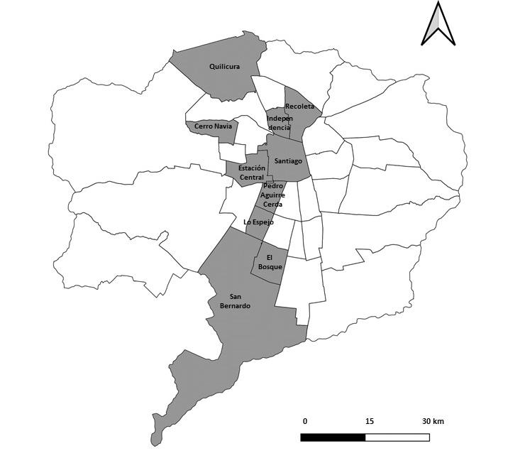
 Figure 1. Main communes with a spread of Haitian population in the Metropolitan Region, according to the 2017 Census. Source: Preparation by the authors.
CRISIS SOCIOPOLÍTICA, PANDEMIA Y VIVIENDA PRECARIA: ¿ARRAIGO HAITIANO EN SANTIAGO DE CHILE? (2019-2021)
JUAN CARLOS RODRIGUEZ-TORRENT, EMILIANO NICOLÁS GISSI-BARBIERI REVISTA URBANO Nº 45 / MAYO 2022-OCTUBRE 2022 PÁG. 2029 ISSN 07173997 / 07183607
As suppliers and consumers, they take refuge in what Mezzadra (2012) calls “autonomy of migrations” or lines of flight, since the control of the body and existence express subjectivity, movement, grammar, the invention of practices, strategies, and tactics with spatial effects (Álvarez, 2019). In communes such as Estación Central, El Bosque, Quilicura, Independencia, and Recoleta, Haitian migrants appropriate the space and spread their practices onto the streets (Figure 1): From their cultural profiles, they cook, sell food, fruit, toiletries, fake branded and sports clothing; they become media subjects. They build houses on vacant lots, violating surveillance and local violence when needing to get food and shelter. As such, receiving immigrants or regulating immigration is not synonymous with the behavior expected (Nussbaum, 2020) by the authorities and citizens.
The methodology is based on regular and systematic fieldwork, performed between 2018 and 2021, in central and pericentral communes of the capital, namely Santiago, Estación Central, Recoleta, and Independencia, as well as on the outskirts of the city, in Quilicura and El Bosque. Ethnographic participant observation and in-depth interviews were made with 40 female and male Haitian migrants, who, at the time, had between two and five years of residence in the country, and were between 21 and 53 years of age, although the predominant age was between 26 and 35 years. The participants had settled during the last decade in habitats where new forms of occupation of public space, social interaction, and segregation are developed, due to neo-colonization and ethno-differentiation, the result of forming networks by kinship and friendship. In the interviews, they told why they decided to emigrate to Chile, how they came, what the experience was like, how they chose their places of residence, what the possibilities of access to housing have been, and they described their movement around the city, and which events have been positive, negative, or strange in their lives, particularly regarding economic-labor aspects and interactions from a cultural and spatial perspective.
The content was analyzed through a thematic mesh created from the interview guideline. The coding was done alongside the categorization, including emerging categories. Finally, the Atlas-ti 7.0 software was used to visualize patterns and disseminate the results. A technical registration form was built which is in the hands of the research team, following the corresponding bioethical safeguards, with an identification criterion by age, gender, profession or trade, and time of entry into the country. The
production of primary data, together with the observation processes in places of high concentration and mobility, was complemented by a search for information in state databases, the National Statistics Institute (INE, 2019), the Socio-Economic Characterization Survey (CASEN, 2017 and 2019), the 2017 Census (INE, 2018), and the Department of Foreign Affairs and Migration (DEM), of the Ministry of Interior and Public Security, as well as INE and DEM (2020).
This section presents some of the results obtained after applying the interviews and observation. For the migrants interviewed, the decision to travel is onerous and involves almost a year of savings. Visits are not contemplated, communication is indirect, via digital media, and most send remittances (US$ 60 per month). All of this does not exclude - in some - the desire to return, even temporarily; or, if given the chance, to activate family networks in key countries such as Canada, the United States, and France. The testimonies confirm this interest that oscillates between staying in Chile, leaving for another country, or returning to Haiti. For example, Antoine (28 years old) points out: “I would like to be able to get a visa and stay in Chile, but the papers are slow ... and you have to find a good job”. For his part, Orel (26) expresses his frustration: “No, I have not been able to travel back. No one has been able to come, because they don’t have enough money.” Meanwhile, Elián (28), in 2018, adds: “I would love to stay in Chile, I am quite stable. I would like to return to my country, but for vacation. I would also like to spend a few months in Haiti before settling definitely in Chile”. Berson (28) meditates about his income: “I can’t live on this... I have my dreams. I have to go to my uncles and cousins, who are in Brazil, Canada, France, and the United States.”
The issue of “visas” or “papers fetishism” is an unresolved problem that lengthens adversity. In this sense, Baptiste (28 years old) states: “The Foreign Office takes a long time to give the papers, without papers there is no job. No company hires undocumented people... We came to work”. And Philiphe (26 years old) adds: “I expected something else... it’s not even half of what we were told.”
The trend is also seen in the words of André (26): I’m on a temporary stay visa... I wanted to process the definitive visa, but with the current issue (social uprising) it’s become more complicated. It hasn’t had a strong enough impact in the short term, but
I hope to solve it so that I can stay here so that in the future, my 5-month-old son can study. The process has been long and sometimes a little tedious because there are people who do not have patience when you don’t understand what they say, because they speak very fast.
And in those of Antoine: “I would improve the time’s processes take so that there aren’t so many lines. Everything is slow, a piece of paper is always missing... and you have to work to eat.”
These testimonies express two perspectives: on one hand, a feeling of faith, that through migratory regulation everything will change, and that there is upward social mobility in the country. On the other hand, the perception of limitations that negate their human rights and the perspective of social mobility predominates. Being “undocumented” defines a distancing from health institutions and a horizon of informality at work, which translates into multidimensional precariousness. “Working in whatever comes” limits and makes personal income and the family unit unstable, and essentially does not allow proving income, entering formal
circuits of consumption, credit, access to rented or own housing, and penetrating other spaces of the city. The lack of educational qualifications - because only 15% of these migrants have higher education (Razmilic, 2019, p. 119)-, the limited recognition of it when they do have it, the lower social capital (support networks), the relationship between documentation, recognition, and low income, forces them to develop the “lines of flight” and being informal workers. They gain the right to the city, but they limit the possibilities of organizing the life project on the aspect of housing within the neoliberal regime.
Housing becomes the most critical element within the migratory imaginary of settling. It is rented and is usually located in communes with downtrodden neighborhoods (Figure 2).
The following testimony raises the issue of housing as a critical problem:
Over there [in Haiti] we lived more comfortably, so to speak... Here almost all the salary goes, I can almost say that the money is paid for a house and we
25
CRISIS SOCIOPOLÍTICA, PANDEMIA Y VIVIENDA PRECARIA: ¿ARRAIGO HAITIANO EN SANTIAGO DE CHILE? (2019-2021) JUAN CARLOS RODRIGUEZ-TORRENT, EMILIANO NICOLÁS GISSI-BARBIERI REVISTA URBANO Nº 45 / MAYO 2022-OCTUBRE 2022 PÁG. 2029 ISSN 07173997 / 07183607
Figura 2. Main communes where the Haitian population lives in Santiago, according to the 2017 Census. Source: Preparation by the authors.CRISIS SOCIOPOLÍTICA, PANDEMIA Y VIVIENDA PRECARIA: ¿ARRAIGO HAITIANO EN SANTIAGO DE CHILE? (2019-2021)
JUAN CARLOS RODRIGUEZ-TORRENT, EMILIANO NICOLÁS GISSI-BARBIERI REVISTA URBANO Nº 45 / MAYO 2022-OCTUBRE 2022 PÁG. 2029 ISSN 07173997 / 07183607
couldn’t find a [home]. The money he [my father] made wasn’t enough for us to rent a good house. Here, one has a base salary of 301,000 pesos, now that they raised it, but a house is worth 400... and if the base salary is 301, then it’s like a thing that doesn’t make sense, like one doesn’t find a better life. One arrives here [to Chile], and realizes that it’s different: Your base salary is worth less than [the rent of] a house. Without a house, you’re not living. We had to be living in rooms and over there one had an entire house... one arrives and is living in one room... everything was horrible. When I arrived, at first, I wanted to return and my father did not let us. He told us that we’re already here and we have to start from scratch. (Eduard, 26 years old)
In this context, Jonnás (26 years old), a janitor at a school in the commune of El Bosque, explains:
I send pictures to my dad, who is a farmer. I show him the house, the neighborhood where I live with my sister, my brother-in-law, and my nephew, and he can’t believe me. Everything is so ugly... it’s poor there, but it looks the same, there’s a style... My dad tells me: ‘That house is going to collapse, how can you live there?’ That’s what it’s like to live here, in these neighborhoods. We could pay for a good house among several, but who gives us credit for what we earn? How many salaries would we have to invest to pay the deposit?
Field records, press reports, and academic reports (Jesuit Migrant Service [SJM] and TECHO-Chile Foundation , 2020) show that housing is, indeed, a critical issue for Haitians and also for many Chileans because its value has grown at an annual rate of 6%, and the economy only at an average rate of 2.1% (El Mercurio, March 18, 2021: A3). Already in 2015, the International Organization for Migration [IOM] pointed out that 85% of Haitians paid rent, 12% paid mortgages, and 2% owned a home. The CASEN 2017 Survey (SJM and Fundación TECHO-Chile, 2020) shows the constant: 39% rent with a contract and 55.7% without it, and only 1.8% had their own house. In addition, there is a national deficit of over 500,000 homes, which mainly affects immigrants who are 5% of the heads of household, and 61% of the total live together with other people, out of which 47% are Haitians. 23% of them are in a state of overcrowding (SJM,
TECHO-Chile Foundation, 2020). It should be mentioned that there are no special housing programs for Haitians, according to the UNASUR agreement. The rental price keeps them from choosing where to live, forcing them to live in a room of 2x2m or 2x3m, as the owners tend to exercise the presumption of insolvency to them, by not having valid papers or work contracts.
As evidenced by the social production and reproduction of the capitalist space (Harvey, 2004), when supply is restricted and the conditions offered are precarious, the content of time and associated labor is a difficult cycle to break. The salaries indicated above and the difficulties of migratory regularization, make housing impossible in the Haitian world. Many of these migrants are faced with abusive rental cycles between private parties, or outright rejection. This is how Luz, a subletter of rooms in the Recoleta commune, outlines it: “I don’t accept Peruvians here, because they have bad habits. I don’t accept Haitians, because they are dirty.”
The residential path shows them, in terms of communication, as “ ethnic zoos ”, “remote and backward” (Delgado, 2007, p.195). Their living is characterized by a lack of protection, between what is “offered” and what “can be paid”, configuring an isotopic grouping pattern from networks of low social capital, with overcrowding in tenements, cites , shanty towns, and old half-collapsed and subdivided houses where they endure in inhumane conditions. They are located in central and pericentral spaces that mark their residential and work circuits since many men begin their working life as assistants in the two open markets the capital has: Lo Valledor and La Vega. Their days run between 5 am and 3 pm. They participate as ” peonetas ” (helpers in trucks), loaders, or by “pulling carts” with horticultural produce, or they set up shop in surrounding streets, especially women, selling meals along public roads (Bravo, 2020). Women usually enter jobs in industrial cleaning companies, and the men who arrived in the country in 2014 and 2015, and who already mastered Spanish, after washing vehicles, gain access to jobs as supermarket shelf-stackers, in hardware stores, warehouses, construction, and as gas station attendants, for about 20 dollars a day, which for some is more advantageous compared to those who have arrived more recently.
The landscape configures a residential collective of precarious housing, with strong internal homogeneity, no social interaction with other groups, and limited movement in the city. The owners have no responsibilities in the care. Up to 8 rooms are built within 65 or 70 meters. They are labyrinthine, dark, and interconnected, with long corridors and no natural light. They house rows of 2x2- or 2x3-meter rooms.
All with shared bathrooms and without hot water, a common kitchen, irregular electrical connections, and full clotheslines. There are 30 and up to 50 families who live in old mansions from the middle of the last century, old tenements, reconditioned sheds, and workshops of all kinds. The environment where helplessness circulates is one and multiple. The space represents residential segregation. It is not functional. It is cold, uncomfortable, and lacks privacy. The informality and the ordering of the space represented by this description, conceptually removed from traditional working-class areas, constitutes a form of production of the city, typical of a downward spiral of ruin and exclusion, apparently unstoppable.
Adversity has led other migrants to opt for the illegal occupation of land, in suburbs that spread their fatalism and impossibility of giving shape to their desire to have a home that sustains their life project and roots. The pattern is the same - rooms of 2x2 or 2x3-, where 4 people live. Inside are the rooms full of shadows, anonymous beds, stacked clothes, a stove, and a refrigerator among the luckiest; a bathroom and a collective shower lined with hipped boards, irregular electrical and drinking water connections. Panels, sheets, construction materials, buckets of water, nylon-covered roofs, and campfires that burn like candles of hope, are shaping a Haitian island. Scattered children and starving dogs complete the ethnographic landscape. There, just waiting for days to go by, they are swallowed by the vortex of being out of work. It is the place where, in the daily struggle, youth is lost and faith is spent, where the most inalienable of rights are lost, and above all, where one no longer wants to be.
In short, they face a precarious system of opportunities and difficult social mobility before the State, the market, and society. “I would like to stay in Chile, stop renting, and for my son to grow up and receive a good education in a good school. I need to have my papers up to date and have the financial capacity to pay for my house and school,” Duma (29 years old) points out on purpose. Mariele (26), a language facilitator, endorses this:
I would like to live in my own house, comfortably, work in my profession, give my son a good education, have my income, and not depend on anyone. You know? And to have a set schedule that depends on me, that does not depend on anyone else... That’s how I’d like to be, but for that, you have to start somewhere: a job and your own house.
The first Haitians to arrive got jobs that generated positive expectations, which implied certain sociability and social integration, helping to reinforce the myth of
Chile through their phones. They also had a kindergarten for their children and health coverage. Over time, they realized that formal employment opportunities require not only migratory regularization, but also specialization, training, and higher qualifications; and that structural informality predominates as a more or less permanent feature, which comes from “cheap, available, trafficable labor and covers everything” (Tijoux and Córdova, 2015, p. 8). Likewise, an awareness is developed that housing represents a necessary place for stability, that gives meaning to rootedness and develops fundamental psychological needs. It constitutes an intimate space, claimed to establish relationships between objects, people, and places. It is not only the shelter but also a discursive aspect that articulates the imaginary of a good life in Chile.
The bifurcation of the desire for decent housing and the one described reveal that, in the contingency, it does not constitute an adequate space of confinement for viral protection and, in structural terms, it is not suitable for settling in either. On the contrary, it highlights the need to build an inclusive city, a neighborhood, but also to resort to a reconsideration of housing, the right to it, and the connection with an organic public space that promotes integration and circulation. Until now, metaphorically, Haitian immigrants live in a place where the streets are closed because there is no city like a common good.
“I send my dad pictures, and he can’t believe it... he thinks they’re going to collapse... they’re so ugly.” The words of Jonnás (26 years old) embody here those of Georges Perec (2020, p. 136): “the uninhabitable” corresponds to “the architecture of contempt...[to] the reduced, the unbreathable, the small, the petty... the hostile, the gray, the anonymous”. Therefore, housing is a classifying entity regarding who one is and what one can aspire to as an immigrant, and it must be understood as the product of a political economy based on asymmetry. It is insufficient just to talk about the difference or the otherness of immigrants. What is important is how the difference is built and how it is consolidated from different devices.
The lack of opportunities, recognition, the economic recession, the limitations to develop their businesses in the pandemic, and access to jobs with protection, weakened the expectations of Haitian immigrants about settling. They also speak of a dystopian Chile. They ran out of money to finance the rent and to guarantee sustenance and food, outlining re-emigration as a possibility and as an action. The vindication of the street
27
CRISIS SOCIOPOLÍTICA, PANDEMIA Y VIVIENDA PRECARIA: ¿ARRAIGO HAITIANO EN SANTIAGO DE CHILE? (2019-2021) JUAN CARLOS RODRIGUEZ-TORRENT, EMILIANO NICOLÁS GISSI-BARBIERI REVISTA URBANO Nº 45 / MAYO 2022-OCTUBRE 2022 PÁG. 2029 ISSN 07173997 / 07183607
CRISIS SOCIOPOLÍTICA, PANDEMIA Y VIVIENDA PRECARIA: ¿ARRAIGO HAITIANO EN SANTIAGO DE CHILE? (2019-2021)
JUAN CARLOS RODRIGUEZ-TORRENT, EMILIANO NICOLÁS GISSI-BARBIERI REVISTA URBANO Nº 45 / MAYO 2022-OCTUBRE 2022 PÁG. 2029 ISSN 07173997 / 07183607
corresponds to a sign of singular political subjectivation, as the transgression of the devices allows them to detach themselves from their altered identity, even when it is insufficient because there is a long way to ensure the “right to the city” as a heterotopic co-production. Being subjects is a struggle against conditions that reproduce the dichotomous epistemology of modernity, and demands clarity on how they are produced structurally and subjectively in their material signs and conditions. Their segregation occurs in the face of the denial of human rights to people who, by migrating, are inscribed in the circulating drift of dehumanization. The relationship between neoliberal capitalism and the bodies it denies and exploits becomes evident, as well as the perpetual “bettering themselves, from the non-place or extraterritoriality and the suspended temporality in which the uprooted find themselves” (Louidor 2016, p.36). An economy that outlawed the independence of the real is now cracking in the interstices of its own systemic creation: through the virus and protest, a passage from precariousness to dispensability is configured. A symbolic defeat of Chilean neoliberalism.
Álvarez, S. (2019). Ecuador-México-EEUU: La producción de una zona de tránsito entre políticas de control y autonomía de la migración. En Cordero, B., Mezzadra, S. y Varela, A. (Coords.), América Latina en Movimiento. Migraciones, límites a la movilidad y sus desbordamientos (pp. 63-98). México: Traficantes de sueños y UACM.
Aninat, I. y Vergara, R. (2019). Inmigración en Chile. Una mirada multidimensional. Santiago: FCE-CEP.
Ávila, C. (2021). Chile: el país más desigual de la OCDE. Recuperado de https://fundacionsol.cl/blog/actualidad-1/post/chile-el-pais-mas -desigual-de-la-ocde-5063
Bravo, A. (2020). Trabajo al por mayor. Migrantes haitianos en el Mercado Lo Valledor. En C. Galaz, N. Gissi y M. Facuse (Eds.), Migraciones transnacionales. Inclusiones diferenciales y posibilidades de reconocimiento. Universidad de Chile, Santiago: Social Ediciones.
Bravo, G. y Norambuena, C. (2018). Procesos migratorios en Chile: Una mirada histórica-normativa, ANEPE. Recuperado de https://anepe.cl › 2020/10 › LIBRO-ANEPE-43
Carrión, F. (2016). Prólogo. El espacio público es una relación, no un espacio. En Ramírez Kuri, P. (Coord.). La reinvención del espacio público en la sociedad fragmentada (pp.13-41). Ciudad de México: Universidad Nacional Autónoma de México.
De Génova, N. y Álvarez, S. (2017). Movimientos migratorios contemporáneos: entre el control fronterizo y la producción de su ilegalidad: Un diálogo con Nicholas De Génova. Íconos. Revista de Ciencias Sociales, (58), 153-164. DOI: http://dx.doi.org/10.17141/ iconos.58.2017.2718
Delgado, M. (2007). Sociedades movedizas. Pasos hacia una antropología de las calles. Barcelona: Anagrama.
Durán, G. (2021). Las 4 caras del trabajo en Chile. Recuperado de https:// www.fundacionsol.cl/blog/actualidad-1/post/las-4-caras-del-mundo-deltrabajo-en-chile-6741
El Mercurio (18 marzo 2021). Editorial. Precios de las viviendas. Recuperado de Blogshttps://www.elmercurio.com
Foucault, M. (1977). Historia de la medicalización. Educación Médica y Salud, 11(1), 3-25.
Galaz, C. y Pérez, L. (2020). Procesos de endeudamiento de la poblaci ó n migrante haitiana y venezolana. Apuntes desde un estudio situado en Quilicura (Chile). Revista Sudamérica (12), 182-207.
Harvey, D. (2004). El “nuevo” imperialismo: acumulaci ó n por desposesi ó n. Socialist Register, 40, 99-128. Recuperado de http://biblioteca.clacso. edu.ar/ gsdl/collect/clacso/index/assoc/D8555.dir/ harvey.pdf
Instituto Nacional de Estadísticas [INE] y Departamento de Extranjería y Migración [DEM]. (2020). Estimación de personas extranjeras residentes habituales en Chile al 31 de diciembre de 2019. Informe técnico: desagregación regional y comunal. Santiago de Chile.
Kremerman, M. (2011). Este no es un modelo de desarrollo, es un modelo de acumulación. Hiedra. Recuperado de https://revistahiedra.cl/hiedrafm/ marco-kremerman-este-no-es-un-modelo-de-desarrollo-es-un-modelode-acumulacion/
Lefebvre, H. (1978). El derecho a la ciudad. Barcelona: Península.
Louidor, W.E. (2016). Articulaciones del desarraigo en América Latina. El drama de los sin hogar y sin mundo. Bogotá: Editorial Pontificia Universidad Javeriana.
Mezzadra, S. (2012). Capitalismo, migraciones y luchas sociales: La mirada de la autonomía. Nueva Sociedad, (237), 159-178.
Moreno, C. (2020). Ciudad de los 15 minutos: ¿en qué consiste la propuesta de Anne Hidalgo para su segundo mandato? LA.network . Recuperado de https://la.network/la-ciudad-de-los-quince-minutos/
Nussbaum, C. (2020). La tradición cosmopolita. Barcelona: Paidós.
Organizaci ó n Internacional para las Migraciones [OIM] (2015). Primera consulta migrante. Resultados de la Encuesta de Caracterizaci ó n de la poblaci ó n migrante, refugiada y solicitante de asilo en la comuna de Quilicura. Organizaci ó n Internacional para las Migraciones. Santiago, Chile.
Perec, G. (2020). Especies de espacios. España: Montesinos.
Razmilic, S. (2019). Inmigración, vivienda y territorio. En Aninat, I. y Vergara, R., Inmigración en Chile. Una mirada multidimensional (pp. 101-145). Santiago: FCE-CEP.
Rodríguez, J. y Gissi, N. (2020). Migración haitiana en Santiago de Chile: Expulsiones, imaginarios e inserción social en un Estado-nación neoliberal. Revista Política, Globalidad y Ciudadanía, 6 (11), 146-170. Recuperado de http://revpoliticas.uanl.mx/index.php/RPGyC/article/view/131
Santi Pereyra, S. (2018). Sobre «ilegales», «irregulares» y «sin papeles». La lucha por la regularización documentaria de los inmigrantes extracomunitarios en España. Estudios Políticos (Universidad de Antioquia), (53), pp. 192-212. DOI: http:// doi.org/10.17533/udea.espo.n53a09
Sassen, S. (2015). Expulsiones. Brutalidad y complejidad en la economía global. Buenos Aires: Katz.
Servicio Jesuita a Migrantes (SJM) y Fundación TECHO-Chile (2020). Acceso a la vivienda y condiciones de habitabilidad de la población migrante en Chile. Informe N°3. Santiago.
Stang, F., Lara, A. y Andrade, M. (2020). Retórica humanitaria y expulsabilidad: migrantes haitianos y gobernabilidad migratoria en Chile. Si Somos Americanos. Revista de Estudios Transfronterizos, 20 (1), 176-201. Recuperado de https://www.sisomosamericanos.cl/index.php/sisomosamericanos/ article/view/958
Suárez-Navaz, L. (2007). La lucha de los sin papeles. Anomalías democráticas y la (imparable) extensión de la Ciudadanía. En Suárez-Navaz, L., Maciá Pareja, R. y Moreno García, Á. (Eds.). Introducción a Las luchas de los sin papeles y la extensión de la ciudadanía. Perspectivas críticas desde Europa y los Estados Unidos y la (imparable) extensión de la ciudadanía (pp. 14-33). Madrid: Traficantes de sueños.
Taylor, CH. (1993). El multiculturalismo y “la política del reconocimiento”. México: Fondo de Cultura Económica.
Telles, E. y Martínez, R. (Eds.) (2019). Pigmentocracias. Color, etnicidad y raza en América Latina. Ciudad de México: Fondo de Cultura Económica.
Thayer, E. (2016). Migración, Estado y seguridad. Tensiones no resueltas y paradojas persistentes. Polis, 15(44), 109-129. DOI: https://dx.doi.org/10.4067/ S0718-65682016000200006
Tijoux, M. (2016). Presentación. En Tijoux , M.E. (Ed.), Racismo en Chile. La piel como marca de la inmigración (pp. 15-18). Santiago: Editorial Universitaria.
Tijoux, M. y Córdova, M. (2015). Racismo en Chile: colonialismo, nacionalismo, capitalismo. Polis, 14 (42), 7-13. DOI: https://dx.doi.org/10.4067/S071865682015000300001
Tironi, E. (2020). El desborde. Vislumbres y aprendizajes del 18-O. Santiago: Planeta.
29
CRISIS SOCIOPOLÍTICA, PANDEMIA Y VIVIENDA PRECARIA: ¿ARRAIGO HAITIANO EN SANTIAGO DE CHILE? (2019-2021) JUAN CARLOS RODRIGUEZ-TORRENT, EMILIANO NICOLÁS GISSI-BARBIERI REVISTA URBANO Nº 45 / MAYO 2022-OCTUBRE 2022 PÁG. 2029 ISSN 07173997 / 07183607
Recibido: 24-10-2021 Aceptado: 25-04-2022
EL ROL CONDICIONANTE DEL ESPACIO URBANO EN POSADAS, ARGENTINA WALTER F. BRITES REVISTA URBANO Nº 45 / MAYO 2022-OCTUBRE 2022 PÁG. 3041 ISSN 07173997 / 07183607
1
THE CONDITIONING ROLE OF URBAN SPACE IN POSADAS, ARGENTINA.
EL ROL CONDICIONANTE DEL ESPACIO URBANO EN POSADAS, ARGENTINA
WALTER F. BRITES 2
1 2
This work was carried out within the framework of the Project, “Desigualdades urbanas y derechos. La Producción Social del Hábitat (PSH) en asentamientos de la ciudad de Posadas, Misiones” (16/H1176), and was financed by CONICET/UNAM.
Doctor en Antropología Social
Consejo Nacional de Investigaciones Científicas y Técnicas (CONICET) y el Instituto de Estudios Sociales y Humanos (IESyH-UNaM). Investigador en el Consejo Nacional de Investigaciones Científicas y Técnicas. (CONICET) y el Instituto de Estudios Sociales y Humanos (IESyH-UNaM) http://orcid.org/0000-0003-2801-5792 briteswalter@yahoo.com.ar DOI: https://doi.org/10.22320/07183607.2022.25.45.03
El caso de la ciudad de Posadas (Argentina) evidencia la relevancia del entorno urbano para las condiciones de vida en los asentamientos. Se analizan aquí las especificidades de los asentamientos, considerando que el entorno urbano de su localización juega un papel importante en términos de oportunidades y restricciones para la calidad de vida de sus habitantes. Metodológicamente, este trabajo se basa en un análisis multimodal y descriptivo, apoyado en entrevistas a vecinos y líderes comunitarios, y complementado a través de información documental. La investigación privilegia la importancia de la espacialidad urbana, explorando cómo se articulan las prácticas y procesos sociales desde el espacio interior del hábitat de los asentamientos con el espacio urbano exterior y circundante. La principal contribución del manuscrito sugiere que, más allá de los problemas multidimensionales del hábitat y de la pobreza de su población, son las características del espacio de la ciudad donde se ubican, las que condicionan más fuertemente la evolución de los asentamientos.
Palabras clave: ciudad, servicios públicos, espacio urbano, hábitat.
The case of Posadas (Argentina) shows the relevance of the urban environment for living conditions in settlements. The particularities of settlements are analyzed here, considering that the urban environment of their location plays an important role in terms of opportunities and restrictions for the quality of life of their inhabitants. Methodologically, this work is based on a multimodal and descriptive analysis, supported by interviews with neighbors and community leaders, and complementing the analysis with documentary information. The research privileges the importance of urban spatiality, exploring how social practices and processes are articulated from the space within the habitat of settlements and the surrounding urban space outside them. The main contribution of the manuscript suggests that, beyond the multidimensional problems of the habitats and the poverty of its population, the characteristics of the city space where they are located are the ones that most strongly condition the evolution of the settlements.
Keywords: city, public services, urban space, habitat.
31
ASENTAMIENTOS Y HÁBITAT EL ROL CONDICIONANTE DEL ESPACIO URBANO EN POSADAS, ARGENTINA WALTER F. BRITES REVISTA URBANO Nº 45 / MAYO 2022-OCTUBRE 2022 PÁG. 3041 ISSN 07173997 / 07183607
EL ROL CONDICIONANTE DEL ESPACIO URBANO EN POSADAS, ARGENTINA WALTER F. BRITES REVISTA URBANO Nº 45 / MAYO 2022-OCTUBRE 2022 PÁG. 3041 ISSN 07173997 / 07183607
The different urban spaces are an expression of sociospatial inequalities and the distribution of opportunities and resources (Capdevielle, 2014). Urban spatiality and its relationship with settlements constitute a problematized interface in this article, in terms of the implications for the habitat and the living conditions of families. Along with poverty, urban spatiality adjacent to settlements entails conditioning factors, which constrain and/or enable certain social practices and access to resources. The case study addressed here offers clues to resize the importance of urban space.
The objective of the study is to know the structures of opportunities and/or adversities linked to the location of settlements within the urban space. Methodologically, the research is multimodal, descriptive, and exploratory. It tries, at the same time, to resize the complexity and heterogeneity of settlements in several aspects: the dimensions of its size/density, the time of consolidation (historicity), its location in the context of the city, the dynamic demands of its inhabitants, the opportunities and/or threats of the context, and its relationship with urban law.
In urban research, spatiality is fundamental, as poverty and inequality are expressed in cities (Ziccardi, 2019), and the heterogeneity of poverty is projected in the urban space (Kaztman, 1999). The importance of space entails various externalities linked to the location of the dwelling, as there are social and economic opportunities associated with its location (Oszlak, 2017). So, it is necessary to understand the space from the articulation between the material and the non-material (Chanampa and Lorda, 2019). It is a perspective that recognizes “situated social action” (Corcuff, 2016) in concrete contexts.
In Posadas and its suburban area, there are 91 settlements that, at the time of being censored, were technically defined by the absence of ownership in the land occupation and the constructive informality of the houses and the surroundings. Apart from the shared characteristics and the processes of social production of the intervening habitat, it is stated here that settlements are not part of a monolithic reality, since they are not all the same, and their study cannot be disassociated from the conditions of their location in urban space. The structural disadvantages and adversities inherent in each settlement, receive the influences of the environment where it is located, so the differential location intervenes as a structure of opportunities and/or adversities for the local life of its residents.
approach to the conceptualization of settlements
Settlements have been defined in different ways, as spaces of uncertainty, instability, and vulnerability (Perlman, 2019), as marginality housing, inadequate housing, lack of integration and state actions (Abufhele, 2019), as “informal development” (Clichevsky, 2009), and have even been recognized as forms of urban growth (García Hernández, 2006). In line with these ideas, Cravino and Vommaro (2018) point out that settlements or land grabs are ways to self-solve housing needs, also constituting another way of selfurbanizing the city.
According to Clichevsky (2009), settlements, as a result of an informal socio-urban process, can be grouped based on two transgressions: (1) those that affect the ownership of the occupied area; and (2) those that derive from the urbanization process. The former refers to both the occupation of public or private lands and individual or collective seizures, irregular lots, etc., where there is no possession of a property deed. The second refers to the occupation of land without urbanenvironmental conditions to be used as residential. In both situations, the illegality of access to land leads to the informality of neighborhood and housing construction (Clichevsky, 2009).
In the case of other Latin American experiences, settlements have been understood as “poverty territories”, where the types of housing marginality have led the State to generate an association between poverty and settlement (Abufhele, 2019). It is important to analyze the situation of settlements in terms of “urban inequalities” and the implications of urban development and the legal city. Urban regulation, the legal-juridical system, and the urban planning of cities operate in an exclusionary way (Torres and RuizTagle, 2019). The emergence of neoliberal urbanism establishes a market logic, of cost-benefit in the intervention, characterized by promoting government actions concomitant with the market and private real estate development. Simultaneously, the city reproduces very precarious urban structures (Brites, 2017).
Despite the multiple risk situations related to the context of poverty and precariousness that impose major constraints, it is necessary to recover the active and creative role of the residents, as habitat producers, under adverse conditions. The Social Production of
Habitat (SPH) is understood as “all those processes that generate habitable spaces, urban components, and housing that are built under the control of selfdevelopers and other social agents that operate on a not-for-profit basis” (Flores Ortiz, 2012, p. 73). On the other hand, SPH includes a diversity of practices ranging from the construction of neighborhoods in land grabs or slums, and the erection of cooperative housing, to family self-construction and the collective and organized self-management of its residents (Zapata, 2016).
The self-construction of housing and the provision of services by its residents can be seen as a response to the “logic of necessity” (Abramo, 2012), where the social organization operates as an urban developer (Torres and Ruiz-Tagle, 2019). In this sense, territorial control is given by the processes of organization and local leadership, as a strategy to achieve urban conditions of habitability (Vega Martínez, Hernández Buelvas, and Barbera Alvarado , 2019).
Settlements and urban spatiality in the city
Settlements, in terms of urban spatiality, can be understood as the socio-spatial construction of places, based on social practices and ways of inhabiting the city (Araya-Ramírez, 2018). From the point of view of policies, urban materiality is objectified in the space, and conditions social practices, without ignoring that people build and de-build the space and habitat where they live. Everyday practices in urban space mediate among social groups and structures and institutions (Jirón and Lange, 2017). Social actors reproduce, but they are also agents of transformation and socio-urban change. They define situations, construct problems and needs, reflect, act, and develop a praxis. This is an assumption that derives from the theory of structuring. The “structuring”, typical of all human activity, is a recursive process of action-structure in the framework of a space-time conjuncture (Giddens, 1995).
From a transversal perspective, it can be said that, among the poor population, participation is crucial to transforming the material conditions of existence. In this line, the production of socio-spatial links (Borroeta, Pinto de Carvalho, Di Masso, and Ossul Vermehren, 2017), articulated to shared needs, becomes a powerful facilitator of collective action logics, which are objectified in space.
In cities, people have opportunity structures that are defined as probabilities of access to goods and
services, or the performance of certain activities. In general terms, opportunities have an impact on the well-being of households, as they allow or facilitate their members to use their own resources (Kaztman, 1999). Thus, according to Kaztman (1999), the concept of assets does not reach an unambiguous meaning if it is not articulated in the structures of opportunities that are generated from the State sector, the market, and civil society. Considering that all households have resources that can turn into assets, which make it possible to take advantage of the opportunities offered by the environment, this research ventures into those opportunity structures, specifically, those that allude to the externalities linked to urban space.
It is essential to recognize the importance of that which is typical of the person in spatial experience (Prieto Peinado, 2014). Along these lines, as will be seen in the case of Posadas, although the settlements express a heterogeneity of characteristics and conditions, in them, their inhabitants are habitat producers who face both the opportunities and the hostilities inherent to the urban environment they inhabit.
Posadas is a medium-sized city (383,000 inhabitants in its suburban area), characterized by having gone through an urban transformation on its coastal front, parallel to the increase in population with high levels of poverty and homelessness 33.6% (Provincial Institute of Statistics and Censuses [IPEC], 2020). A survey carried out between 2014 and 2015 by the Municipality of Posadas (2015) registered 63 settlements with 5,302 households. Meanwhile, by 2018, the National Register of Popular Neighborhoods detected 67 settlements in Posadas and another 24 in its conurbation area, Garupá (National Register of Popular Neighborhoods [RENABAP], 2018). Beyond district boundaries and disparate figures, many of these settlements have common characteristics.
This research aims at resizing the study of settlements, analyzing how the population experiences the typical effects of poverty, on being accompanied by the unique conditions of the urban and socio-spatial context they live in. Therefore, as a starting point, it is felt that the experiences that manifest themselves in the settlements cannot be understood from an insular approach, but rather it is essential to circumscribe them to the more general context of the urban
33
ASENTAMIENTOS Y HÁBITAT EL ROL CONDICIONANTE DEL ESPACIO URBANO EN POSADAS, ARGENTINA WALTER F. BRITES REVISTA URBANO Nº 45 / MAYO 2022-OCTUBRE 2022 PÁG. 3041 ISSN 07173997 / 07183607
EL ROL CONDICIONANTE DEL ESPACIO URBANO EN POSADAS, ARGENTINA WALTER F. BRITES REVISTA URBANO Nº 45 / MAYO 2022-OCTUBRE 2022 PÁG. 3041 ISSN 07173997 / 07183607
transformation of Posadas. Settlements are not closed units, and their inhabitants, regardless of segregation, are exposed to some form of articulation with socio-urban processes.

Faced with this panorama, given its location in space, three types of settlements can be operationally distinguished: (a) in the context of urban revaluation, (b) in the context of urban consolidation, and (c) in the context of urban expansion. This typology allows approaching the complex dimensions of living regarding the structuring conditions of socio-spatial inequalities.
This research was based on fieldwork carried out between 2018 and 2019 in different settlements located in different urban contexts of Posadas. During the first year, the settlements were visited and a record was taken of the infrastructure and services available in the surroundings. In a second stage, in 2019, 40 qualitative interviews were conducted with neighbors and community leaders. The choice of the informants was based on how long they have lived there and their
i nvolvement in the organizational processes to improve the habitat.
In its quantitative phase, the study made progress in the statistical analysis of secondary information from several agencies, such as the diagnosis of the situation of settlements in Posadas (Municipality of Posadas, 2015), and data from the National Registry of Neighborhoods (RENABAP, 2018). The information collection provided by both censuses made it possible to triangulate information and reveal new emerging categories involved in the analysis of the problem, mainly those related to habitat, urban services, and infrastructure.
For the geolocation of the settlements in the different urban areas of the city, the OpenStreetMap platform was used. Meanwhile, for the adjustment and spatial delimitation of some settlements, the GRASSGIS software was used, through which maps on urban routes, public infrastructure, and services were prepared. The empirical material analyzed described different dimensions linked to housing, services, and infrastructures, such as roads, water, and energy networks, transport, employment activities, the construction of collective spaces, environmental adversities such as landfills or wastewater, etc. All of these dimensions have been useful for the construction of categories.
The operational distinction of the three types of settlements made it possible to examine different situations: those closest to the urban downtown and coastal areas (urban revaluation context); the settlements that are located closer to the city center, where services in the immediate surroundings are abundant (urban consolidation context); and, finally, settlements that are farther away and relegated, with limited services and different adversities (urban sprawl context). All of these situations do not determine but do condition, the quality of life, and the habitat in the settlements studied.
The hypothesis suggests that, apart from the possibilities of population agency, the social production processes of the habitat make differential use of the resources of the environment, since the heterogeneity of Posadas settlements is conditioned by the externalities (infrastructure and services) of the environment adjacent to the urban space. In other words, the unique characteristics of each settlement are also conditioned by the different urban contexts where each settlement is located.
It can be said that the settlements discussed here have received infrastructure improvements and services in the immediate surroundings. They are located in areas of influence of the new
city waterfront (coastal area) and, therefore, in the new public and/or recreation spaces set up, such as parks, green areas, etc. The most evident one is the proximity to the central areas of the city, where infrastructure networks and services are qualitatively superior to other areas.
Despite the precarious and informal working conditions the inhabitants have here, access to the labor market is broader and urban transport is not an unavoidable necessity for mobility, since for many people “everything is close and there are always odd jobs”. In addition, there is a greater possibility of contact with groups from high social strata, which is very useful for activities such as domestic service. The surrounding urban space also facilitates self-employment practices, such as street vending in the public spaces along the waterfront.
Among other features, it can be noted that the habitat of these settlements is developed in a contradictory urban setting. On one hand, they are located in highly revalued and beautified urban environments (close to parks or green spaces) and, on the other, are located in the interstices, where the what is inside them, the provision of infrastructure and services is still precarious and/or lacking, but accessible. It is clear that the places these settlements occupy are interstitial remnants, but strategic in the urban context. They are remnants in the face of the infrastructure works that the formal city was leaving behind, and are strategic in the face of structures of opportunities their location grants (proximity to work, services, new spaces for recreation, etc.).
Despite the set of circumstances that can be seen as a very advantageous opportunity structure for the population, urban renewal and the increase in urban quality in the residential environment promote threatening removal processes. Indeed, the confluence of urban materials, with new uses and valuations of new spaces, is energizing different interests in their occupation.
The changes in the environment have placed the settlements in revalued areas, prone to new visibilities and arising both from proposals of official intervention plans and from the presence and claims of supposed private owners who demand possession of the land. Situations where threats and still unresolved litigation have emerged (Cerro Pelón, Viejo Rowing, and Ch. 210). These legal and juridical intimidation practices make the future life in these settlements even more uncertain.
Under given experiences, beyond those linked to the evolution of the SPH, within the settlements, their inhabitants have shown some consolidation of the collective action against eviction attempts, as happened in Chakra 189, in 2016, where the resistance of its occupants, and the struggle articulated towards social and political movements, thwarted the eviction. Residents of the San Roque and Cerro Pelón settlements have also resisted similar attempts.
35
ASENTAMIENTOS Y HÁBITAT EL ROL CONDICIONANTE DEL ESPACIO URBANO EN POSADAS, ARGENTINA WALTER F. BRITES REVISTA URBANO Nº 45 / MAYO 2022-OCTUBRE 2022 PÁG. 3041 ISSN 07173997 / 07183607
EL ROL CONDICIONANTE DEL ESPACIO URBANO EN POSADAS, ARGENTINA WALTER F. BRITES REVISTA URBANO Nº 45 / MAYO 2022-OCTUBRE 2022 PÁG. 3041 ISSN 07173997 / 07183607

Settlements in the context of urban consolidation are located in areas where the urban fabric has become denser, exhausting (and saturating) large remaining spaces for new neighborhoods. The population, the greater construction activities, and the density of service networks and infrastructure, make commercial, labor, educational, and recreational activities possible, which have the potential to be articulated to the place of residence. In this way, these are
settlements that have remained over time, in a context where the dynamics of urbanization processes were consolidating, with more and better facilities and services: schools, healthcare centers, transportation, shops, recreational spaces, etc.
All of these settlements are located, more or less, in the heart of the consolidated urban fabric. The area covers Uruguay Ave. to the coast of the Martires stream (east-west) and from Centennial Ave. to Quaranta Ave. (north-south). Specifically,
they are located in the boundary of the so-called Chacras, partially occupying them and coexisting with other social sectors.

Many of these settlements have been where they are for decades, and neighborhood associations (neighborhood commissions) have fostered social production of habitat processes for the improvement and organization of the collective spaces, such as football pitches, soup kitchens, churches, etc. In other experiences, self-management practices have been combined with claims to improve services (water and energy), build sewerage systems, improve access roads, etc.
Beyond the activities carried out by the residents themselves to improve their habitat, the consolidation of the surrounding urban space facilitated a set of very profitable externalities for local life. In this way, a public project, the extension of pavement, water network, or social housing plan, has led to the growth of an area, bringing infrastructure and services that, later, have been useful for the inhabitants. As examples of the above, Chacras 96, 101, 112, 126, and 127 can be mentioned, where the large housing complexes built by Yacyretá also enabled schools, healthcare centers, squares, and other community facilities that, later, were appropriated by the residents of the area’s settlements, just as one of those interviewed by this study comments: “We have been here in Yohasá (Ch.112) since 1975, this area was not so beautiful, then with the Yacyretá houses, more people came and the government fixed more things, there are more services now” (Interview Ch. 112).
To the west, near the Villa Cabello housing complex, the settlements of Chacras 158 and 159 (La Favela) take advantage of the services and infrastructure of the surroundings such as the Regional Hospital, the different schools, Sarmiento Park, and the broad commercial area on Tambor de Tacuari Ave. In the opinion of a neighbor of Chacra 158, “it is not necessary to go downtown, everything you need is in the area”. The area also makes it possible to work in informal jobs, as there are car washes, motorcycle workshops, grocers, small shops, etc. Some neighbors have stated that they work in domestic service or street vending.
In summary, despite poverty and precarious living conditions, the residents of these settlements have been able to make the most of the advantages and externality of the surroundings, which shows the importance of the articulation of local life with adjoining socio-urban processes.
In general, these types of settlements are located to the south and southwest of the city. More than two decades ago, this area of the city had remnants of land for urban expansion.
Between the 1980s and 1990s, neighborhoods were built on lots for lower and middle-income sectors, where the relicts of hills and large green areas made spaces for the construction of housing complexes possible, while the “occupation or land grabs” by the poor social sectors and without possibilities of formal access to land and housing, began.
Despite the inherent adversities in the settlements, the issues they experience have different magnitudes, such as the distances to the city center, the deficits in transport and services, dirt streets, poor infrastructure, environmental pollution, etc. The hostile spatial limitations, within each settlement (intricate corridors, overcrowding, lack of streets, flooding, terrain issues, etc.), are magnified by the external spatial arrangements, adjacent to the settlements of the periphery suburban territory.
The inhabitants of the most distant settlements are aware that they live in remote, poorly communicated areas, with scarce and deficient services that enhance their isolation and vulnerability. Remoteness can also be interpreted as disadvantageous, both for leaving the neighborhood and looking for work, and their integration with other social sectors.
In the periphery, not only the location of settlements is problematic, but also, in many cases, the terrain and
37
ASENTAMIENTOS Y HÁBITAT EL ROL CONDICIONANTE DEL ESPACIO URBANO EN POSADAS, ARGENTINA WALTER F. BRITES REVISTA URBANO Nº 45 / MAYO 2022-OCTUBRE 2022 PÁG. 3041 ISSN 07173997 / 07183607
Figure 3. Settlements according to the urban context. Source: Preparation by the author.EL ROL CONDICIONANTE DEL ESPACIO URBANO EN POSADAS, ARGENTINA WALTER F. BRITES REVISTA URBANO Nº 45 / MAYO 2022-OCTUBRE 2022 PÁG. 3041 ISSN 07173997 / 07183607
composition of the soil they occupy (muddy, stony, unstable soils, etc.). The construction of settlements on land unsuitable for urbanization and without prior treatment has been generating repeated problems, as occurs in sectors of Los Lapachitos, where flooding or waterlogging is worsened on rainy days, due to the lack of piping for drains. Located on the edge of the mighty Zaimán Stream and steep terrain, the La Tablada, La Cantera, and Villa Cariño settlements go through critical situations with heavy rains, and even though some families have been relocated to homes in Iprodha (San Jorge), those who have remained have not seen an improvement in their living with the fluvial works that have been carried out.
In general terms, in the Posadas settlements, poverty levels are pressing and create synergy with the lack of work or with precarious, intermittent, and piecemeal employment. To survive, families develop access strategies to goods and services there. However, the urban context and its spatiality are conditioning factors when accessing resources, such as sources of employment, shops, healthcare services, education establishments, etc.

The habitat of the poorest forms an ecology of poverty and ecosystems to which its inhabitants must adapt to survive
(Daher Hechem and Sandoval Luna, 2016). Although the settlements have shared characteristics - poverty, precarious employment, housing deficit, irregular access to services, etc. -, the fact that their inhabitants are habitat producers (Brites and Ávalos, 2020) cannot be forgotten. On the other hand, urban space provides opportunities that the residents can take advantage of (Kaztman, 1999). Hence, it is necessary to rescue the importance of socio-spatial links (Borroeta et al ., 2017).
The settlements, in the context of urban revaluation, enjoy the best locations, proximity to the riverfront, and to the neuralgic urban areas, where the service and infrastructure networks are optimal. The urban work market is more dynamic and has social and spatial proximity to other social sectors. Therefore, it demonstrates more right to urban space, as Oszlak (2017) would say. On the opposite side, the settlements in the context of urban expansion are, for the most part, on the periphery, on the outskirts of the city, where there is greater socio-spatial segregation, precarious and deficient services, and worse environmental conditions. It is a space where the problems of poverty are resized. Thus, for the poorest families, environmental problems related to waste and landfills are an aspect that contributes to deepening the inequalities of opportunities and possibilities between the different social sectors (Gómez, 2016). This is a phenomenon that is also interpreted in terms of socioenvironmental segregation (Salgado, Romero, Vásquez, and Fuentes , 2009).
In a relatively intermediate situation, the settlements are located in the context of urban consolidation, where families who have progressively seen improvements in public works and urban equipment in the built environment reside. The adjoining territory provides the necessary externalities for life and, in many cases, urbanization programs have been implemented within the settlements. These areas of urban consolidation are the result of a temporary structuring (Aguilar Díaz, 2011) and the construction of a way of life that develops in parallel to the urbanization process.
At the socio-territorial level, the distant location of settlements with respect to the areas with the greatest urban consolidation of the city, imposes some obstacles and limitations, fundamentally for urban mobility (transport costs and remoteness from centrality), so that physical distance has an impact on social distance (Brites, 2019). In addition, the drinking water and electricity services are precarious: intermittent power cuts, lack of public lighting, low pressure in the water networks, etc. A structural problem becomes visible that not even the irregular/informal connection made by the inhabitants themselves can solve.
The settlements located in the southernmost periphery present an inherent uniqueness to the environment, since the prevailing natural countryside landscape, low population density, and abundant vegetation, make these areas have more rural than urban characteristics (el Piedral, Estepa, Paraísos, Los Patitos, El Porvenir, Néstor Kirchner, Belén settlements, etc.). The space they occupy conditions the poor connection with the city, the inhospitable places aggravate the condition of structural shortcomings, reinforce the deprivation of access to fundamental urban services, hinder the quality of life, and perpetuate sociospatial distances. In this sense, the more peripheral the settlements are located, the more segregated they are.
Despite the collective activities of social production of habitat that can be found (the opening of internal corridors, filling the land, setting up football pitches, the extension of street lighting, etc.), the precarious conditions of these settlements are compounded by the shortage or lack of infrastructure and services in the suburban area. At a habitat level, the issue of environmental sanitation is another variable to be taken into account in the sanitary vulnerability of the population, since environmental deterioration and the formation of landfills feed the production of a more precarious habitat. Inside, there is no waste collection service (except in adjoining spaces) and garbage is often disposed of by open burning it, which pollutes the air and soil, with all the consequences this implies for people’s health (inhalation of toxic gases, heavy metals, particulate matter, etc.).
In the areas that are most integrated into the urban space, the inhabitants of the settlements enjoy job opportunities, access to service networks, proximity to shops, etc. While in the peripheral and more remote areas, the services of the environment are more precarious, deficient, and depend on urban transport, work is scarce, and the environmental deterioration is notorious.
The case study found that the poverty situation in the settlements is not per se the only adversity that affects the living conditions of its residents, but it is necessary to resize the implications of the differential urban space where they are located. The built environment restrains and/or enables better living conditions in settlements, in terms of structures of opportunities and/or adversities linked to the habitat.
Urban space provides externalities for urban life. Therefore, it plays a conditioning role in the habitat of settlements. The advantages and disadvantages of the urban territory should be viewed dynamically and as unstable. The findings evidenced in the case studied suggest the following:
• In the areas of urban revaluation, settlements have certain environmental benefits: there is proximity to the urban labor market, services, and infrastructure, and urban transport is not a necessity. However, the context of revaluation is also one of renewal. Real estate pressure is pressing, urban legislation is more restrictive, and intervention programs are emerging. A situation is then revealed that threatens (via eviction) the permanence of the settlements. Settlements located in areas of urban consolidation are located in areas full of services and infrastructure. The city was growing and they were left in the middle of the consolidated urban fabric. Inside the settlements, the habitat has benefited from the opportunities of the surroundings.
• In the areas of urban expansion, the settlements are located farther from downtown, in the context of the sprawl of the urban fabric. They often occupy leftover spaces, where services are deficient or absent. In the distant and discontinuous periphery of the urban fabric, socio-spatial segregation is a problem. Urban legislation is more permissive and flexible. There are new and intermittent encroachments, landfills, waste burning, and environmental adversities.
39
ASENTAMIENTOS Y HÁBITAT EL ROL CONDICIONANTE DEL ESPACIO URBANO EN POSADAS, ARGENTINA WALTER F. BRITES REVISTA URBANO Nº 45 / MAYO 2022-OCTUBRE 2022 PÁG. 3041 ISSN 07173997 / 07183607
40 ASENTAMIENTOS Y HÁBITAT EL ROL CONDICIONANTE DEL ESPACIO URBANO EN POSADAS, ARGENTINA WALTER F. BRITES REVISTA URBANO Nº 45 / MAYO 2022-OCTUBRE 2022 PÁG. 3041 ISSN 07173997 / 07183607
Despite the particularities of the Posadas case, the categories presented here could have a potential heuristic contribution to the analysis of other similar experiences in the Latin American context. Poverty and settlements are linked, in fact, to survival strategies, and the reproductive resources needed to face life. Urban externalities close to places of life are associated, hence the location of the neighborhood plays a vital role. Transport, healthcare, education, security, drinking water, municipal services, leisure spaces, etc., are factors that optimize the material conditions of the existence of households.
Finally, the research tried to generate new empirical contributions to the conceptual reflection, from the approach of new questions and alternative analytical dimensions. A task that, undoubtedly, more than just knowing, led to discussing and seeing the importance of the right to the city and urban spatiality for living conditions in settlements.
Abramo, P. (2012). La ciudad com-fusa: mercado y producción de la estructura urbana en las grandes metrópolis latinoamericanas. EURE, 38 (114), 35-69. DOI: https://dx.doi.org/10.4067/S0250-71612012000200002
Abufhele, V. (2019). La política de la pobreza y el gobierno de los asentamientos informales en Chile. EURE 45(135), 49-69. DOI: https://dx.doi. org/10.4067/S0250-71612019000200049
Aguilar Díaz, M. (2011). Del espacio al lugar: un análisis de la consolidación urbana local desde la perspectiva narrativa. Alteridades, 21(41), 145160. Recuperado de http://www.scielo.org.mx/scielo.php?script=sci_ arttext&pid=S0188-70172011000100014
Araya Ramírez, I. (2018). La espacialidad urbana en la construcción socio espacial de los lugares: una mirada desde el giro espacial. Revista Geográfica de América Central, 3(61E), 553-568. DOI: https://doi.org/10.15359/rgac.613.29
Borroeta, H., Pinto de Carvalho, L., Di Masso, A., y Ossul Vermehren, M. (2017). Apego al lugar: una aproximación psicoambiental a la vinculación afectiva con el entorno en procesos de reconstrucción del hábitat residencial. INVI, 32(91), 113-139. DOI: https://dx.doi.org/10.4067/S0718-83582017000300113
Brites, W. (2017). La ciudad en la encrucijada neoliberal. Urbanismo mercado-céntrico y desigualdad socio-espacial en América Latina. Urbe. Revista Brasileira de Gestão Urbana, 9 (3), 573-586. DOI: https://doi. org/10.1590/2175-3369.009.003.AO14
Brites, W. (2019). Ciudades, teorías e investigación urbana: una aproximación a los procesos urbanos de Posadas y Encarnación. Buenos Aires: CICCUS.
Brites, W. y Avalos, M. (2020). Asentamientos informales y hábitat: un análisis de casos en la ciudad de Posadas, Argentina. Procesos Urbanos, 7(1), 1-11. DOI: https://doi.org/10.21892/2422085X.476
Capdevielle, J. (2014). Espacio urbano y desigualdades: las políticas públicas y privadas en la ciudad de Córdoba, Argentina. (1990- 2011). Cuadernos Geográficos, 53(2), 135-158. DOI: https://doi.org/10.30827/ cuadgeo.v53i2.2224
Chanampa, E. y Lorda, M. (2019). Asentamientos informales y regularización urbana. La producción de territorialidades en tensión. Bitácora, 30 (1), 141150.
Clichevsky, N. (2009). Algunas reflexiones sobre informalidad y regularización del suelo urbano. Bitácora urbano territorial, 14(1), 63-88. Recuperado de https://revistas.unal.edu.co/index.php/bitacora/article/view/18508
Cravino, M. y Vommaro, P. (2018). Asentamientos en el sur de la periferia de Buenos Aires: orígenes, entramados organizativos y políticas de hábitat. Población & Sociedad, 25(2), 1-27. DOI: http://dx.doi.org/10.19137/pys-2018250201
Corcuff, P. (2016). Las nuevas sociologías. Principales corrientes y debates, 19902010. Buenos Aires: Siglo XXI.
Daher Hechem, A. y Sandoval Luna, A. (2016). Hábitat y ecología de la pobreza. Urbano, 19 (33), 6-13. Recuperado de http://revistas.ubiobio.cl/ index.php/RU/article/view/2356
Flores Ortiz, E. (2012). Producción social de la vivienda y el hábitat. Bases conceptuales y correlación con los procesos habitacionales. México: HIC.
García Hernández, N. (2006). Los asentamientos informales en Latinoamérica: ¿un factor de crecimiento urbano o productor de otra ciudad? Urbana, 39 (1), 13-28.
Giddens, A. (1995). La constitución de la sociedad Bases para la teoría de la estructuración. Buenos Aires: Amorrortu Editores.
Gómez, J. (2016). Análisis de caso sobre las problemáticas ambientales de los residuos sólidos urbanos en Villa Jardín, partido de Lanús provincia de Buenos Aires. Universidad Nacional de Quilmes. Recuperado de http://ridaa.unq. edu.ar/handle/20.500.11807/220
Instituto Provincial de Estadísticas y Censos [IPEC] (2020). Pobreza e Indigencia Multicausal 4° Trimestre 2020. IPEC. Recuperado de https:// ipecmisiones.org/ sociedad/condiciones-de-vida/pobreza-e-indigencia/ multicausal/aglomera do-posadas-4-trimestre-2020/
Jirón, P. y Lange, C. (2017). Comprender la ciudad desde sus habitantes. Relevancia de la teoría de prácticas sociales para abordar la movilidad. Cuestiones de Sociología, 16, e030. DOI: https://doi. org/10.24215/23468904e030
Kaztman, R. (1999). Activos y estructuras de oportunidades. Estudios sobre las raíces de la vulnerabilidad social en Uruguay. Montevideo: Programa de las Naciones Unidas para el Desarrollo (PNUD Uruguay)/ Comisión Económica para América Latina y el Caribe (Cepal, Oficina de Montevideo).
Municipalidad de Posadas (2015). Diagnóstico del estado de situación de asentamientos en el Municipio de Posadas 2014-2015. Coordinación del programa de regularización de espacios públicos y provisión de agua.
Oszlak, O. (2017). Merecer la ciudad. Los pobres y el derecho al espacio urbano Buenos Aires: Eduntraf Editorial.
Perlman, J. (2019). Ciudades sin tugurios, ciudades sin alma. Repensando los conceptos y las consecuencias de la marginalidad en las favelas de Río de Janeiro. Andamios, 16(39), 207-233. DOI: http://dx.doi.org/10.29092/uacm. v16i39.680
Prieto Peinado, M. (2014). Asentamientos espontáneos, tácticas en los márgenes de la ciudad de Sevilla, Los Perdigones. INVI, 29 (82), 91-131. DOI: https://dx.doi.org/10.4067/S0718-83582014000300004
Registro Nacional de Barrios Populares [RENABAP] (2018). Ministerio de Desarrollo Territorial y Hábitat. Recuperado de https://www.argentina.gob. ar/barriospopulares.
Salgado, M., Romero, H., Vásquez, A. y Fuentes, C. (2009). Segregación SocioAmbiental en espacios urbanos. Estudio de caso en la comuna de Peñalolén. Cuadernos de Trabajo, (1), 14-32. Subprograma Domeyko, Política, Pobreza y Exclusión Social, Universidad de Chile. Recuperado de https://repositorio. uchile.cl/handle/2250/118082
Torres, D. y Ruiz-Tagle, J. (2019). ¿Derecho a la vivienda o la propiedad privada? De la política pública a la informalidad urbana en el Área Metropolitana de Lima (1996-2015). EURE, 45(136), 5-29. DOI: https://dx.doi.org/10.4067/S025071612019000300005
Vega Martínez, A., Hernández Buelvas, E. y Barbera Alvarado, N. (2019). Configuración territorial del hábitat en el asentamiento informal Alfonso López de la ciudad de Montería-Colombia. INVI, 34(97), 81-103. DOI: https:// dx.doi.org/10.4067/S0718-83582019000300081
Zapata, C. (2016). El rol de la institucionalidad pública en experiencias autogestionarias de vivienda en Argentina. Economía, sociedad y territorio, 16(50), 229-264. Recuperado de http://www.scielo.org.mx/scielo. php?script=sci_arttext&pid=S1405-84212016000100229
Ziccardi, A. (2019). Nueva arquitectura espacial, pobreza urbana y desigualdad territorial. Polis, 1(15), 7-31. Recuperado de http://www.scielo.org.mx/scielo. php?script=sci_arttext&pid=S1870-23332019000100007
41
ASENTAMIENTOS Y HÁBITAT EL ROL CONDICIONANTE DEL ESPACIO URBANO EN POSADAS, ARGENTINA WALTER F. BRITES REVISTA URBANO Nº 45 / MAYO 2022-OCTUBRE 2022 PÁG. 3041 ISSN 07173997 / 07183607
Recibido: 18-11-2021 Aceptado: 11-05-2022
ANALYSIS OF THE TERRITORIAL COMPETITIVENESS OF TOURISM IN BELLO, COLOMBIA
METROPOLIZACIÓN Y TURISMO EN CIUDADES INTERMEDIAS
ANÁLISIS DE LA COMPETITIVIDAD TERRITORIAL DEL TURISMO EN BELLO, COLOMBIA
ELKIN MUÑOZ, ALEXANDRA LÓPEZ MARTÍNEZ, YUNIER SARMIENTO RAMÍREZ REVISTA URBANO Nº 45 / MAYO 2022-OCTUBRE 2022 PÁG. 4253 ISSN 07173997 / 07183607 ELKIN MUÑOZ 2 ALEXANDRA LÓPEZ MARTÍNEZ 3 YUNIER SARMIENTO RAMÍREZ 4
METROPOLIZACIÓN Y TURISMO EN CIUDADES INTERMEDIAS ANÁLISIS DE LA COMPETITIVIDAD TERRITORIAL DEL TURISMO EN BELLO, COLOMBIA
This work is part of the Project, “Competitividad territorial de ciudades intermedias latinoamericanas. Un estudio de caso múltiple.” (206001222). It was financed by Tecnológico de Antioquia.
Doctor en Estudios Territoriales
Tecnológico de Antioquia, Medellín, Colombia. Docente ocasional, Facultad de Ciencias Administrativas y Económicas. https://orcid.org/0000-0003-1667-5849 elkin.munoz@tdea.edu.co
Doctora en Estudios Territoriales
Tecnológico de Antioquia, Medellín, Colombia. Docente ocasional, Facultad de Ciencias Administrativas y Económicas. https://orcid.org/0000-0002-2966-4965 alexandra.lopez55@tdea.edu.co
Doctor en Economía
Universidade Federal do Amazonas, Manaus, Brasil. Profesor visitante junior, Programa de Pós-graduação em serviço Social e sustentabilidade na Amazônia (PPGSS) do Instituto de Filosofia, Ciências Humanas e Sociais (IFCHS)
https://orcid.org/0000-0002-7261-7515 yunier@ufam.edu.br DOI: https://doi.org/10.22320/07183607.2022.25.45.04
Las ciudades intermedias al interior de un Área Metropolitana quedan, en muchas ocasiones, supeditadas al rol asignado para el funcionamiento general del sistema que se construye en torno a la ciudad central, lo que restringe un posible proceso de desarrollo independiente que las convierta en territorios competitivos. En esta medida, el objetivo de este artículo es analizar la influencia de los procesos metropolitanos en el comportamiento del turismo en el Municipio de Bello, Colombia, para la consolidación de su competitividad territorial. La metodología utilizada es mixta, y se emplean técnicas como las encuestas, la cartografía y los recorridos territoriales. Se concluye que la imagen de ciudad insegura y la poca historia turística de Bello en el Área Metropolitana del Valle de Aburrá disminuye la capacidad de competencia territorial del turismo urbano, pero el turismo rural ─localizado en San Félix─ representa una gran oportunidad para que el municipio aproveche sus particularidades y el potencial del mercado metropolitano.
Palabras clave: Área Metropolitana, ciudad intermedia, competitividad territorial, turismo.
Intermediate cities inside a Metropolitan Area are often subject to the role entrusted for the general operation of the metropolitan system built around the central city. This limits a possible independent development process that turns them into competitive territories. In this regard, the purpose of this article is to analyze the influence of metropolitan processes on the behavior of tourism in the Municipality of Bello, Colombia, for the consolidation of its territorial competitiveness. A mixed-method was used, with techniques such as surveys, cartography, and territorial routes. It is concluded that the image of an unsafe city it conveys, and the little tourist history of Bello in the Metropolitan Area of the Aburrá Valley, reduces its capacity for the territorial competition of urban tourism. However, rural tourism located in San Félix would be a great opportunity to take advantage of its distinctive features and the potential of the metropolitan market.
Keywords: Metropolitan Area, intermediate city, territorial competitiveness, tourism
43
METROPOLIZACIÓN Y TURISMO EN CIUDADES INTERMEDIAS ANÁLISIS DE LA COMPETITIVIDAD TERRITORIAL DEL TURISMO EN BELLO, COLOMBIA ELKIN MUÑOZ, ALEXANDRA LÓPEZ MARTÍNEZ, YUNIER SARMIENTO RAMÍREZ REVISTA URBANO Nº 45 / MAYO 2022-OCTUBRE 2022 PÁG. 4253 ISSN 07173997 / 07183607
ANÁLISIS DE LA COMPETITIVIDAD TERRITORIAL DEL TURISMO EN BELLO, COLOMBIA ELKIN MUÑOZ, ALEXANDRA LÓPEZ MARTÍNEZ, YUNIER SARMIENTO RAMÍREZ REVISTA URBANO Nº 45 / MAYO 2022-OCTUBRE 2022 PÁG. 4253 ISSN 07173997 / 07183607
The current global context makes it necessary to compete not just at a business level, but also at the territorial level. While the use of competitiveness on a national scale has been criticized -because it implies seeing the country as a company and constitutes a very simplistic use of the concept (Krugman, 1995)-, it is a strategy that has made it possible to add social and environmental dimensions to the economic one. From this perspective, when talking about territorial competition, not just business productivity, its costs, and other internal actions are taken into account. It is also essential to consider the surroundings of these companies, which include institutions, society, and natural resources.
It is not about the traditional way of evaluating the vocations of territories and defining a certain economic activity to be promoted, but rather the possibility of finding links between the territorial players so that the particular conditions of the territory can be economically exploited. This does not mean that the process cannot just focus on a particular activity. In fact, in many cases, this is what happens. What makes the dynamics of territorial jurisdiction different is that this seeks to strengthen relationships between local actors, places, the resident community, authorities, local businesses and other sectors, academia, etc., around a certain activity that, in turn, becomes the image the city portrays to the outside. This use of resources, not from a traditional commodification, but player participation, aims at contributing to a true distribution of income and access to new opportunities that improve the capacities and living conditions of the local population. It can then be said that all territories have a potential for territorial competitiveness, insofar as they manage to acknowledge their particularities, generate income from them, and distribute them among their members. For this, each one must take on a role within the process.
In this context, this article aims at analyzing the influence of metropolitan processes on the behavior of tourism in Bello, Colombia, to consolidate its territorial competitiveness. Although there are many studies on urban tourism in Latin American cities (Alvarado & Batista, 2019; Bertoncello & Luso, 2016; de la Calle, 2019; Hiernaux & González, 2014; Judd, 2003; Rodriguez, 2021), there are still few that focus on observing their territorial competitiveness (Barrado, 2016; Díez, 2012; Trujillo, 2008), as they focus primarily on the competitiveness of tourism companies (Alcocer, 2013; Gómez, 2018; T. Mercado, Viloria & L. Mercado, 2019).
In addition, the specificities of the territory selected here make its consolidation even more complex. Bello is bordered by Medellín, the second most important city in Colombia, economically and demographically speaking, so its internal processes largely depend on it. Given this situation, the municipality forms a very interesting case study, since an attempt is made to generate an internal dynamic there, amid the strong appeal of Medellín.
On the other hand, studies on intermediate cities have addressed different problems, such as their growth (Torres & Caicedo, 2015) and their role in the interaction between large urban and rural conurbations (Llop, Iglesias, Vargas & Blanc, 2019), excluding cities that are part of large metropolitan areas, their development processes, and their contributions to territorial development (Méndez, Michelini & Romeiro, 2006; Sornoza, 2013; Wilches & Niño, 2017), alongside some social problems within them (Borsdorf, Sánchez & Marchant, 2008; Novillo, 2018; Prieto, 2012). Consequently, the contribution of this study is its approach to an intermediate city within a metropolitan area from a territorial competitiveness perspective, unlike traditional approaches that study these two conditions independently, and from a perspective that poses the intermediate city as a counterpart to large urban conurbations.
The article comprises a total of five sections, namely: theoretical framework, case study, methodology, results and discussion, and finally, a series of conclusions and recommendations.
This article starts from the relationship between four core concepts for the construction of its theoretical purpose: metropolization processes, intermediate cities, territorial competitiveness, and tourism. The processes of metropolization imply a “structuring of social and economic forms in one or more subnational areas, that are distinguished by an accentuated centralization of activities, functions, and relationships, as well as by a high population concentration” (Villa, 1980). However, in Latin America, these processes are framed within urbanization catapulted by the limited opportunities offered by more spread out rural and urban areas. It was in the large urban conurbations where the best opportunities were found, and that led to urbanization being reflected in a growing metropolization of the main cities (Bähr & Borsdorf, 2005; de Mattos, 2006; Gross, Galilea & Jordán, 1988).
However, these concentrating processes of industrial urbanization have been transformed by globalization and the newly emerging urban forces (Martínez, 2016). The novelties in information and communication technologies (ICT) and the forms of productive organization have led to new urban structures that are mainly characterized by spatio-temporal compression (Harvey, 1994) and that, likewise, generate effects on the sprawl of cities, since the space should also reflect the reduction of barriers to the free flow of capital and goods, resulting in an accumulation of capital in a shorter time. This implies the construction of new infrastructures, and a greater relationship between territories to make production processes more flexible, among other processes with a direct impact on urban areas and their growth. In this way, the growing mobility within cities, the ever-growing presence of financial services, the expulsion of industrial activities in favor of residential or service uses, and the growing leisure and entertainment economy, configure new urban characteristics that also modify the roles of territories within large metropolitan conurbations.
The intermediate city becomes a functional node “that will facilitate the decentralization of national and regional activities making the intermediation between different scales possible, and enhancing collaborative governance such as the right to the city” (Otero & Llop, 2020, p. 4). The adjective “intermediate” refers to the qualitative, to its role as an intermediary between parts of the urban system, leaving aside the traditional way of seeing demographic size only as the organizer of cities (Prieto, Schroeder & Formiga, 2011). This does not mean that the size of the population is not important, as it is because it gives it a fundamental urban center character, but, it is in the extent that it is related to other nodes or cities that its intermediation role will be more relevant, since there, its area of influence and its ability to direct or mediate in large flows of the system can be raised.
Such a conceptualization would seem to indicate that intermediate cities are independent of the processes of metropolization, as they are an intermediate stage between that urban extreme and other purely rural ones. In addition, to analyze them outside the metropolitan scenario would be to denature their dominant territorial context (Alfonso, 2018) and also a mistake, as it would be to deny the fact that they are intermediate cities, since despite having certain forms of metropolitan organization and administration, they still have their own structures of government that require particular decision making to take advantage of a suitable form of the dynamics where they are embedded, and not be banished to serve the roles or resources that the central city needs.
Figure 1. Theoretical construction of territorial competitiveness. Source: Preparation by the authors.
At this point, it is essential to bring forward actions that leverage territorial competitiveness processes in these cities. In Figure 1, the theoretical position regarding this concept is shown. As can be seen, there is a great need for interaction between the local territory, built for a specific geography, history, and social relations that have been achieved to the extent that the social and business players of the territory interact. Likewise, the international market marks many of the actions of business and social players, which is why that relationship with the international context is pivotal. In this way, territorial competitiveness will only be achieved when the territory is simultaneously positioned economically, i.e., it is inserted into regional, national, or international markets, and the living conditions of its inhabitants can be improved.
Territorial competitiveness is understood, then, from a broad relationship within the territories that seeks to transform and leverage the development process. It is impossible to talk about a competitive territory that only benefits business people. It must be an articulated process where all local players benefit (Barrado, 2016).

45
METROPOLIZACIÓN Y TURISMO EN CIUDADES INTERMEDIAS ANÁLISIS DE LA COMPETITIVIDAD TERRITORIAL DEL TURISMO EN BELLO, COLOMBIA ELKIN MUÑOZ, ALEXANDRA LÓPEZ MARTÍNEZ, YUNIER SARMIENTO RAMÍREZ REVISTA URBANO Nº 45 / MAYO 2022-OCTUBRE 2022 PÁG. 4253 ISSN 07173997 / 07183607
46 METROPOLIZACIÓN Y TURISMO EN CIUDADES INTERMEDIAS
ANÁLISIS DE LA COMPETITIVIDAD TERRITORIAL DEL TURISMO EN BELLO, COLOMBIA ELKIN MUÑOZ, ALEXANDRA LÓPEZ MARTÍNEZ, YUNIER SARMIENTO RAMÍREZ REVISTA URBANO Nº 45 / MAYO 2022-OCTUBRE 2022 PÁG. 4253 ISSN 07173997 / 07183607
Figure 2. Location of the Municipality of Bello. Source: Preparation by the authors.

It is also important to highlight the urban processes that today mark the impact of tourism on intermediate cities. Globalization has driven competition between territories, which has led regions, municipalities, and cities to create territorial images and brands that differentiate them from others. In fact, “tourism offers cities a way of inclusion suitably based on their particularities, converted into tourist attractions and complemented with the necessary and suitable services and facilities” (Bertoncello & Luso, 2016, p. 111).
In this sense, tourist attractions must be transformed into products that can be marketed to visitors, which could have an economistic tinge if it is only responsible for preparing a specific image while disregarding local players, turning them into an imposition and generating inequalities in the territory (Muñoz, 2017). Another possibility is to build them with the active participation
of the population and local players who transmit to said product-specific local aspects that which makes it attractive and where all those involved would intervene and benefit. This work assumes this path since it makes territorial competitiveness possible. The first option, as mentioned above, would point to predatory tourism of local resources and, usually, envisaged from interests outside the territory that contribute little to improving the living conditions of residents.
Bello is a Colombian intermediate city with a population of approximately 522,200 people (National Administrative Statistics Department [DANE, in Spanish], 2019). It is part of the Metropolitan Area of the Aburrá Valley and is part of a conurbation with the Municipality
Municipal Development Plan 2020-2023. For the Bello we want Local
Identification of economic vocations for the Municipality of Bello Local
Municipality of Bello’s prospective strategic tourism development plan Local
Valle de Aburrá Tourism Development Plan 2008-2015 Regional
Valle de Aburrá Tourism Development Plan 2017-2026 Regional
of Medellín (Figure 2). It was a municipality with high industrial importance, especially in the textile area thanks to its flagship company, Fabricato (Rodríguez, 2011).
In general, the main backbone of this metropolitan was its textile companies, which would later enter into crisis when facing international competition after the economic opening up of the 1990s, where the industry and the economy headed in reverse (Sánchez, 2013). This pattern is repeated in Bello, which leads to the spaces destined for industry being gradually transformed into residential and commercial uses (Palacio, 2021). The metropolization processes of Medellin have led to a conurbation in the north with this municipality, which imposes a necessary articulation between the policies of the two in order to organize a periphery territory characterized by “an inappropriate or non-existent urban planning and having an organic urban sector formed by circulating roads solely for connection, both within and between the municipalities” (Patiño, 2010, p. 46). In broad terms, the northern area of the Aburrá Valley, where Bello is located, is the poorest area of this Metropolitan Area, and the one that faces the greatest social and economic difficulties.
The research presented used an eminently qualitative approach, both for the epistemological position for its development and for the research techniques used. However, some quantitative research techniques were also used to give mathematical support to some of the ideas
raised about the analyzed territory. Hence, it can be stated that the methodology was mixed. In the same way, it starts from a hermeneutical position, which implies an interpretation of reality in light of theoretical postulates that would allow understanding the facts and the information produced by the case study.
The research consisted of three stages. The first was an approach to municipal authorities to know their position and the information available on the competitiveness of the territory. To this end, two workshops were held with a total of six officials of the Economic Development Directorate of the Mayor’s Office of Bello. In that approach, it was decided that the specific economic sector to work on would be tourism, since it is one of the local aims. In the second stage, a tracing of secondary information was made, such as the tourist plans that have been built in the municipality and the region. In this case, a literature review technique was used and a total of five official documents on tourism were found (Table 1).
The third stage was devoted to a cartographic analysis and to georeferencing tourism companies, to identify the places involved in the activity, the type of tourism developed, and the possible involvement of local conditions in these decisions. For this stage, a heat map of the companies was developed using Geographic Information Systems (GIS). The fourth and last stage comprises speaking directly to companies, 15 in total, to identify their position regarding tourism activity and the relationship with the territory and with competitiveness. With these companies, it was possible to apply an online survey, and territorial tours were made with two locals, which allowed expanding the vision of its specific attractions.
47
METROPOLIZACIÓN Y TURISMO EN CIUDADES INTERMEDIAS ANÁLISIS DE LA COMPETITIVIDAD TERRITORIAL DEL TURISMO EN BELLO, COLOMBIA ELKIN MUÑOZ, ALEXANDRA LÓPEZ MARTÍNEZ, YUNIER SARMIENTO RAMÍREZ REVISTA URBANO Nº 45 / MAYO 2022-OCTUBRE 2022 PÁG. 4253 ISSN 07173997 / 07183607
Table 1. Official documents revised. Source: Preparation by the authorsANÁLISIS DE LA COMPETITIVIDAD TERRITORIAL DEL TURISMO EN BELLO, COLOMBIA ELKIN MUÑOZ, ALEXANDRA LÓPEZ MARTÍNEZ, YUNIER SARMIENTO RAMÍREZ REVISTA URBANO Nº 45 / MAYO 2022-OCTUBRE 2022 PÁG. 4253 ISSN 07173997 / 07183607
The companies surveyed were selected from a list provided by the Municipal Mayor’s Office of Bello with a representative criterion that considered the different economic sectors that served local tourism, namely: gastronomy, transport, lodging, craftwork, and travel agencies. In addition, the instrument was sent virtually to verify the responsiveness of local entrepreneurs by this media, which yielded a fairly low result initially, demonstrating a difficulty for territorial competitiveness. Finally, the sample was selected by convenience among those who answered and were interested in taking part.

The survey inquired about the position of entrepreneurs regarding the competitiveness of tourism in the territory and the relationship with other players in the municipality, and some indicators were created around these players. They were asked to draw up a ranking among different local players, indicating if they knew them and how many
relationships they had with them. It was defined that each player would be given a particular weight, considering the position given by the entrepreneurs. The weights were as follows: 1 if in the first position, 0.5 in the second position (1/2), 0.33 in the third position (1/3), 0.25 in the fourth position (1/4), and 0.2 for the fifth position (1/5). Subsequently, that weight was multiplied by the number of times the player located in that position appeared. Then, these values were added together to calculate the particular index of each one. For example, if player A was ranked by two entrepreneurs in the first position, and by another entrepreneur in the third position, they would have a weight of 1 for the first position and a weight of 0.33 for the third position. Multiplying those weights by the times they were named there would result in 1x2=2 and 0.33x1=0.33. The sum of these figures gives an index for that player of 2.33. Thus, a recognition index and a relationship index were calculated.
Bello has been a territory strongly hit by the urban conflict of the Aburrá Valley, which has led to the stigma of it being a violent municipality with many social problems (Cruz, 2019). This promotes, of course, that the municipality is not identified as a tourist destination within the Metropolitan Area of the Aburrá Valley. Spatially, the highest homicide rate is located in certain neighborhood lines, which makes it extremely difficult to have tourist activities (Jiménez & Rentería, 2019). Despite being an integral part of the metropolitan area, the municipality has evidenced imaginaries that go against its socio-economic strengthening, thus turning it into what is known as a highly populated dormitory territory, but with few internal economic dynamics that offer new alternatives for the population, which is relatively poor compared to the rest of the metropolitan area (Gobernación de Antioquia, 2018).
Despite this, a recent dynamic in the municipality is high urban development, where shopping centers and housing for the middle and upper class have been built (Muñoz, 2018), something that is not traditional in the municipality since most of its population is workingclass and moves to work south of the Aburrá Valley or to Medellín. Thus, these new constructions are generating a transformation in the territory that can start to attract cultural and business tourists, given the new commercial offers of the municipality.
Additionally, the Mayor’s Office of Bello (2013), in its Strategic Tourism Plan, maintains that tourism in the municipality is configured from its relationship with the Aburrá Valley, aware that tourists visiting Bello will arrive mainly from the other municipalities in this region. Along the same vein, the tourist potential of the Municipality of San Félix was identified, especially thanks to its paragliding activity, the landscapes it offers, and the proximity to the Municipality of San Pedro de Los Milagros and the Milk Route. In addition, different types of tourism potential are proposed in the municipality: cultural tourism (mainly in the heart of the municipality with the churches and the Choza Marco Fidel Suárez Museum), ecotourism (especially on Quitasol Hill), rural tourism (in San Felix, because of its culinary activity and the uses of milk by part of the peasant community), adventure tourism (ecological trails, hiking, and, above all, paragliding), and business tourism (from the wide range of commercial services offered in Bello).
The map presented in Figure 4 was built following a cartographic analysis of all the tourist companies located in the municipality that the current National Tourism
Registry (RNT) has. In this, it is seen that there are three points where most of the local tourist offer is located. The first of these is Niquia (the secondary red dot located close to the boundary with Copacabana), where the commercial and service offer in the municipality has been concentrated. This has been the pole of development during the 2000s and 2010s and has as its main tourist anchors, the Puerta del Norte Shopping Center and the Tulio Ospina Sports Facility. The second is the more intense red dot that represents the downtown area of Bello, where historically the main economic, social, and commercial activity of the municipality was located, as well as the local authority. In this space are the Church of Nuestra Señora del Rosario, the Chapel of Nuestra Señora del Rosario de Hato Viejo, Santander Park, the Monument, and Birthplace of Marco Fidel Suárez, the Station, and Workshops of the Antioquia Railway, so it is a specific place for cultural tourism. The third point is in the town of San Félix, located outside the urban area of Bello which, as mentioned above, has been positioning itself as a key destination for the municipality, since it is suitable for rural, adventure, and ecological tourism.
From a spatial point of view, the tourism that has been developed in the municipality is diverse, which is a good sign despite not being very recognized in the region due, in large part, to the imaginary that predominates about it, which has made its tourist potential invisible: an unsafe, industrial, and residential place. As for local tourism in the Aburrá Valley, the main destinations tend to be Girardota, for recreational farms and religious tourism; Barbosa, for ecological tourism; Envigado, for business and shopping tourism; and Medellín, a preferred destination for cultural and urban tourism. The only attraction that has been positioned in Bello is paragliding, but because one of the most important ways to get to the municipality belongs to Medellín, most of the metropolitan population considers that this destination belongs to that city, not to Bello. Perhaps it has been strengthened for this very reason, since it is not associated with the negative image of violence in the municipality. It should be remembered that part of the commercial and tourist offer is located in the neighborhoods and lines linked to the main homicides identified by Jiménez and Rentería (2019), especially those downtown, which has a direct and negative impact on the decision to visit and access that specific tourism.
Territorial competitiveness is positioned as the capacity territories can achieve and that allows them to strengthen their economic activities through a clear relationship with
49
METROPOLIZACIÓN Y TURISMO EN CIUDADES INTERMEDIAS ANÁLISIS DE LA COMPETITIVIDAD TERRITORIAL DEL TURISMO EN BELLO, COLOMBIA ELKIN MUÑOZ, ALEXANDRA LÓPEZ MARTÍNEZ, YUNIER SARMIENTO RAMÍREZ REVISTA URBANO Nº 45 / MAYO 2022-OCTUBRE 2022 PÁG. 4253 ISSN 07173997 / 07183607
ANÁLISIS DE LA COMPETITIVIDAD TERRITORIAL DEL TURISMO EN BELLO, COLOMBIA ELKIN MUÑOZ, ALEXANDRA LÓPEZ MARTÍNEZ, YUNIER SARMIENTO RAMÍREZ REVISTA URBANO Nº 45 / MAYO 2022-OCTUBRE 2022 PÁG. 4253 ISSN 07173997 / 07183607
the resident population and the improvement of their living conditions. Tourism in Bello has a differentiating potential to contribute to territorial competitiveness, taking into account that for this activity to work, it must be articulated with the local community. Although there is potential for urban tourism, this should not be the one that is most conducive to the municipality due to the territorial context where it is located. Namely, Bello is an intermediate city within a Metropolitan Area led by Medellín. This and other municipalities that are also experiencing the expansion of the city are already positioned locally and regionally, so one should bet on attractions that are different from those that already exist, even more if the fact that local inhabitants are the main target audience is considered.
The municipality of San Félix has the greatest capacity to strengthen tourism in the municipality and boost territorial competitiveness. There it would be possible, firstly, to offer a different product from the rest of the region, thus attracting the visitors needed for the activity
to be profitable. Secondly, it would allow including a rural area in the economic and social dynamics of the city, which has been mainly concentrated in the urban area. However, it is important to be careful in the process used to strengthen the tourist use of San Félix, since this will determine whether or not the relationship between the different players involved is achieved. If these close relationships are fostered, the tourism dynamic will boost territorial competitiveness; otherwise, it will simply be a process of economic growth. Figure 5 shows the analysis of local players through recognition and relationship. It is seen that there is much work to do in the municipality in terms of relations between players, as only two are highly recognized and have some kind of interaction with the entrepreneurs of the sector, while others may have even more recognition than relationship, which is a red flag for territorial development.
The results of the surveys show the frequent need to take more advantage of the rural areas of Bello, especially San Félix, to offer a product that can be differentiated

from the rest of the Aburrá Valley. In fact, the proposal arises to create an airpark that allows having a better infrastructure for paragliding and landing more easily. In this park, it is expected that several tourist and community players can converge to offer gastronomic products and craftwork, among others. This would be an architectural symbol that evokes the memory of the territory through a specific image, which is undoubtedly a necessity since this must be consolidated amid so many metropolitan forces that offer tourist products and services, and this activity is certainly unique in the region.
In the same context, one of the entrepreneurs mentioned that there is little belonging to the municipality, people are hired from other places and even local travel agencies offer products in other territories. This situation is a consequence of the metropolitan relations that lead to a much better estimation to satisfy some needs, than to do it inside Bello, given the proximity to Medellín. This is reflected in the conditions for hiring people from outside the municipality, as well as in the offer of tourist services to other regional municipalities. The vision that other territories can offer better conditions, characteristics, or professionals will have to be transformed so that tourism can achieve territorial competitiveness based on joint work between local players and activities. This does not mean having to work outside regional relations; on the contrary, that condition should be used as a differentiator and as a potential market. So the essence for it to be an intermediate city that can be strengthened amid a metropolis is that it reaches a dynamic of differentiationcooperation with other municipalities belonging to the metropolitan region.
Bello is an intermediate city that is undergoing a broad metropolization process from the city of Medellín, which limits, to a certain extent, the type of economic and social dynamics that can be moved forward independently to solve the particular problems of the territory. Therefore, it is necessary both to articulate efforts with the other metropolitan players and to differentiate to take advantage of local opportunities. Although Bello has some potential for urban tourism, it has major weaknesses compared to the other municipalities of the Aburrá Valley, namely that they already have a more defined tourist history. Likewise, Bello has an image in the region of widespread insecurity, which would not make it sustainable to start a process to create territorial competitiveness with tourism potential.
The opposite happens in San Félix, a rural area that is distant from the image of insecurity, with a clearer history in tourist terms, and with a clear product differentiation. The problem faced in this case is that in the regional imagination, San Félix is conceived as belonging to Medellín, so it would be necessary to develop a promotion process that would ratify it as part of the Bellanita territory, and involve several local players. This is to achieve an articulation capable of generating new revenues for the territory, which are distributed among the different players involved, to consolidate territorial competitiveness based on tourism. The success of this exercise will depend on whether the other places, stories, and activities with potential in the municipality can take off as domestic tourist destinations.
As noted, this specific case shows that intermediate cities linked to metropolitan areas have a double challenge in terms of territorial competitiveness. On one hand, metropolitan dynamics require certain functions or contributions for the proper functioning of the entire urban conurbation they are part of, so they cannot freely undertake individual processes that represent a substantial change in the living conditions of their inhabitants. On the other hand, territorial competitiveness is based on the ability to internalize local territorialities in productive processes, and to promote a broad participation of social players, so that the benefits are distributed equitably. In this type of city, it is not so easy to identify and fully differentiate those territorialities and potentialities, since immersion in metropolitan processes limits this. However, it is a necessary exercise so that inequalities in these conurbations are also reduced through processes carried out by local players.
Alcaldía de Bello (2013). Plan prospectivo estratégico de desarrollo turístico Municipio de Bello, 2013-2023. Bello: Alcaldía de Bello.
Alcocer, J. (2013). Competitividad en el sector turístico: una revisión de la literatura. Revista Lebret, 5, 271–291.
Alfonso, O. (2018). Metropolización versus ciudades intermedias. La incompatibilidad del auge de las ciudades intermedias en la fase actual de la urbanización de la población colombiana. Revista de Antropología y Sociología: VIRAJES 20 (1), 83–111. DOI: https://doi. org/10.17151/rasv.2018.20.1.5
Alvarado, I. y Batista, E. (2019). Situación geográfica turística en la era urbana y devenir campo-ciudad en América Latina. Investigaciones Geograficas , (99), 1–26. DOI: https://doi.org/10.14350/rig.59792
51
METROPOLIZACIÓN Y TURISMO EN CIUDADES INTERMEDIAS ANÁLISIS DE LA COMPETITIVIDAD TERRITORIAL DEL TURISMO EN BELLO, COLOMBIA ELKIN MUÑOZ, ALEXANDRA LÓPEZ MARTÍNEZ, YUNIER SARMIENTO RAMÍREZ REVISTA URBANO Nº 45 / MAYO 2022-OCTUBRE 2022 PÁG. 4253 ISSN 07173997 / 07183607
METROPOLIZACIÓN Y TURISMO EN CIUDADES INTERMEDIAS ANÁLISIS DE LA COMPETITIVIDAD TERRITORIAL DEL TURISMO EN BELLO, COLOMBIA ELKIN MUÑOZ, ALEXANDRA LÓPEZ MARTÍNEZ, YUNIER SARMIENTO RAMÍREZ REVISTA URBANO Nº 45 / MAYO 2022-OCTUBRE 2022 PÁG. 4253 ISSN 07173997 / 07183607
Bähr, J. y Borsdorf, A. (2005). La ciudad latinoamericana: La construcción de un modelo. Vigencia y perspectivas. Revista de Ciudad, Urbanismo y Paisaje Ur[b]Es , (2), 207–221.
Barrado, D. (2016). Destino turístico y competitividad territorial: una aproximación desde la geografía a la competitividad territorial y al papel del territorio como factor competitivo. Esic Market Economics and Business Journal, 47 (2), 253–273.
Bertoncello, R. y Luso, R. (2016). Turismo urbano en contecto metropolitano: Tigre como destino turístico en el Área Metropolitana de Buenos Aires (Argentina). Cuadernos de Geografía: Revista Colombiana de Geografía, 25(2), 107–125. DOI: https://doi. org/10.15446/rcdg.v25n2.56905
Borsdorf, A., S án chez, R. y Marchant, C. (2008). Aprendiendo de los errores. La necesidad de cambios a la política de vivienda en ciudades intermedias chilenas. Revista Scripta Nova Revista Electrónica de Geografía y Ciencias Sociales , 12 (270). Recuperado de http://www. ub.edu/geocrit/sn/sn-270/sn-270-51.htm
Cruz, R. (2019). Bello, Antioquia: más que una disputa de bandas delincuenciales de barrio. Verdad Abierta . Recuperado de https:// verdadabierta.com/bello-antioquia-mas-que-una-disputa-debandas-delincuenciales-de-barrio/
De la Calle, M. (2019). Turistificación de centros urbanos: clarificando el debate. Boletín de La Asociación de Geógrafos Españoles , 83 (2829), 1–40. DOI: https://doi.org/10.21138/bage.2829
De Mattos, C. (2006). Modernización capitalista y transformación metropolitana en América Latina: cinco tendencias constitutivas. En A. Geraiges, M. Arroyo y M. Silveira (Eds.), América Latina: cidade, campo e turismo ( pp. 41-73) San Pablo: CLACSO.
Departamento Administrativo Nacional de Estadísticas [DANE]. (2019). Censo Nacional de Población y Vivienda 2018, Colombia. Demografía y población. Recuperado de https://www.dane.gov.co/ index.php/estadisticas-por-tema/demografia-y-poblacion/censonacional-de-poblacion-y-vivenda-2018
Díez, D. (2012). La competitividad turística en espacios interiores: una propuesta metodológica para la determinación de competidores potenciales. Cuadernos de Turismo, (30), 109–125.
Gobernación de Antioquia. (2018). Encuesta de Calidad de Vida 2017. Gobernación de Antioquia . Recuperado de https://antioquia.gov.co/ index.php/encuesta-calidad-de-vida-2017-índice-multidimensionalde-condiciones-de-vida
Gómez, S. (2018). Desarrollo y competitividad turística: un destino urbano de México. Turismo y Sociedad, 23, 183–197. DOI: https://doi. org/10.18601/01207555.n23.09
Gross, P., Galilea, S. y Jordán, R. (1988). Metropolización en América Latina y el Caribe. Calidad de vida y pobreza urbana. Revista EURE, 14 (43), 7–51.
Harvey, D. (1994). La construcción social del espacio y del tiempo: Una teoría relacional. Geographical Review of Japan, 67 (2), 126–135.
Hiernaux, D. y González, I. (2014). Turismo y gentrificación : pistas teóricas sobre una articulación. Revista de Geografía Norte Grande, (58), 55–70.
Jiménez, W. y Rentería, R. (2019). Aportes de la complejidad para la comprensión de las dinámicas de la violencia en las ciudades. Caso de estudio: las ciudades de Bello y Palmira, Colombia (años 20102016). Revista Criminalidad, 62 (1), 9–43.
Judd, D. (2003). El turismo urbano y la geografía de la ciudad. EURE, 29 (87), 51–62.
Krugman, P. (1995). Competitividad: una peligrosa obsesión. Ensayos de Economía, 6 (9–10), 17–34. Recuperado de https:// revistas.unal.edu.co/index.php/ede/article/view/23735/24422
Llop, J. M., Iglesias, B., Vargas, R. y Blanc, F. (2019). Las ciudades intermedias: concepto y dimensiones. Ciudades , (22), 23–43. DOI: https://doi.org/10.24197/ciudades.22.2019.23-43
Martínez, P. (2016). La metropolización afectada por la globalización: reflexión epistemológica sobre la nueva revolución urbana. Cuadernos de Geografía: Revista Colombiana de Geografía, 25(2), 77–105. DOI: https://doi.org/10.15446/rcdg.v25n2.56907
Méndez, R., Michelini, J. J. y Romeiro, P. (2006). Redes socioinstitucionales e innovación para el desarrollo de las ciudades intermedias. Ciudad y Territorio. Estudios Territoriales , 38 (2006), 377–395.
Mercado, T., Viloria, A. y Mercado, L. (2019). Competitividad de los recursos turísticos: una propuesta de indicadores para su medición en la región Caribe colombiana. Revista de Economía del Caribe, (24), 95–113.
Muñoz, E. (2017). Territorio de postal: la dualidad del turismo en Santa Fe de Antioquia (Colombia). Cuadernos de Geografía: Revista Colombiana de Geografía, 26 (2), 153–174. DOI: https://doi. org/10.15446/rcdg.v26n2.59237
Muñoz, J. (2018). Asentamientos informales y pobreza en Bello, la otra cara del “progreso”. Aproximación crítica desde el enfoque de derechos. Revista de Trabajo Social, (27), 151–167.
Novillo, N. (2018). Cambio climático y conflictos socioambientales en ciudades intermedias de América Latina y el Caribe. Letras Verdes, Revista Latinoamericana de Estudios Socioambientales , (24), 124–142. DOI: https://doi.org/10.17141/letrasverdes.24.2018.3323
Otero, A. y Llop, J. M. (2020). La ciudad intermedia: crecimiento y dinámicas de desarrollo. Territorios , (43), 1–8.
Palacio, S. (2021). Mercado inmobiliario y producción del espacio en la transformación urbana de Bello. Universidad de Antioquia.
Patiño, J. E. (2010). Bordes conurbados metropolitanos, interacción socio-espacial y fragmentación territorial en el Área Metropolitana del Valle de Aburrá. Medellín: Universidad Nacional de Colombia.
Prieto, M. (2012). Segregación socio-residencial en ciudades intermedias. El caso de Bahía Blanca-Argentina. Breves Contribuciones del IEG , (23), 129–156.
Prieto, M., Schroeder, R. y Formiga, N. (2011). Ciudades intermedias: dinámica y perspectivas. El caso de Bahía Blanca - Argentina. Revista Geográfica de América Central, (Número especial EGAL), 1–17.
Rodríguez, J. (2011). Antecedentes y caracterización de la metropolización del Valle de Aburrá (Col). Iustitia. Revista de la Devisión de Ciencias Jurídicas y Políticas , (9), 59–94. DOI: https://doi. org/10.15332/iust.v0i9.892
Rodriguez, L. (2021). Descentralización de la oferta turística como estrategia de competitividad urbana: Programas de “Barrio” en la Ciudad de México y la Ciudad Autónoma de Buenos Aires. PASOS. Revista de Turismo y Patrimonio Cultural, 19 (1), 9–25. DOI: https://doi. org/10.25145/j.pasos.2021.19.001
Sánchez, A. (2013). La reinvención de Medellín. Lecturas de Economía, (78), 185–227.
Sornoza, J. (2013). Gobernanza urbana, competitividad y procesos de renovación en las ciudades medias españolas. Bolet í n de la Asociacion de Ge ó grafos Espa ñ oles , (61), 47–66.
Torres, P. y Caicedo, C. (2015). Las ciudades intermedias con mayor potencial en Colombia. Un sistema de identificación. Recuperado de https://publications. iadb.org/publications/spanish/document/Las-ciudades-intermedias-conmayor-potencial-en-Colombia-Un-sistema-de-identificación.pdf
Trujillo, J. (2008). El territorio como factor de competitividad de un destino turístico. El caso de la capital del Estado de México. Quivera, 10 (2), 131–152.
Villa, M. (1980). Consideraciones en torno al proceso de metropolización en América Latina. Notas de Población, (24), 57–105.
Wilches, L. y Niño, J. L. (2017). Internacionalización territorial y competitividad en América Latina. Una perspectiva desde las ciudades intermedias. Espacios , 38 (54), 9–18.
53
METROPOLIZACIÓN Y TURISMO EN CIUDADES INTERMEDIAS ANÁLISIS DE LA COMPETITIVIDAD TERRITORIAL DEL TURISMO EN BELLO, COLOMBIA ELKIN MUÑOZ, ALEXANDRA LÓPEZ MARTÍNEZ, YUNIER SARMIENTO RAMÍREZ REVISTA URBANO Nº 45 / MAYO 2022-OCTUBRE 2022 PÁG. 4253 ISSN 07173997 / 07183607
54
POLÍTICA DE SUELO URBANO EN SAN CARLOS DE BARILOCHE (2001-2019) APORTES PARA UN BALANCE CRÍTICO TOMÁS GUEVAR, JULIETA WALLACE REVISTA URBANO Nº 45 / MAYO 2022-OCTUBRE 2022 PÁG. 5463 ISSN 07173997 / 07183607
Recibido: 19-11-2021 Aceptado: 25-04-2022
POLÍTICA DE SUELO URBANO EN SAN CARLOS DE BARILOCHE (2001-2019) APORTES PARA UN BALANCE CRÍTICO
TOMÁS GUEVARA 2 JULIETA WALLACE 3
This article is part of the Project, PI 40-B-783 “Hábitat y Planeamiento Urbano en San Carlos de Bariloche: Políticas Públicas y Actores Sociales”. Resolution of the Chancellor N° 235/2020. It was financed by Universidad Nacional de Río Negro.
Doctor en Ciencias Sociales Universidad Nacional de Río Negro - Agencia Nacional de Promoción Científica y Técnica, San Carlos de Bariloche, Argentina Investigador Adjunto Consejo Nacional de Investigaciones Científicas y Técnicas (CONICET) https://orcid.org/0000-0003-2457-2743 tguevara@unrn.edu.ar
Abogada Universidad Nacional de Río Negro, San Carlos de Bariloche, Argentina Profesora Adjunta de la Escuela de Producción, Tecnología y Medio Ambiente. https://orcid.org//0000-0003-1192-6610 jwallace@unrn.edu.ar
Este artículo aborda las políticas de acceso al suelo urbano en cuanto elemento central para garantizar condiciones de habitabilidad para los sectores populares. En ese marco, se analizan las alternativas de producción de suelo urbano desarrolladas en la ciudad de San Carlos de Bariloche, Río Negro, en el período post-crisis de 2001, en particular luego de la crisis habitacional de 2006-2008, hasta el año 2019, con la finalidad de realizar un balance crítico de la implementación de la política de producción de lotes con servicios. A partir de un abordaje metodológico documental y cualitativo, se examinan las diferentes operatorias iniciadas por el Estado municipal, atendiendo a las modalidades de adquisición del suelo, las formas de financiamiento de la infraestructura, los destinatarios y su forma de organización, entre otras variables. Los resultados de la investigación muestran un esfuerzo del gobierno local de San Carlos de Bariloche orientado a urbanizar 140 hectáreas de suelo urbano, pero también evidencian las limitaciones en la implementación de la urbanización del mismo. El trabajo intenta aportar a la discusión sobre las causas de la informalidad urbana y su relación con las políticas habitacionales y urbanas adoptadas desde los gobiernos locales en la región latinoamericana. La producción de lotes con servicios constituye un pilar fundamental de la política urbana, sin embargo, su abordaje en investigación ha sido acotado, por lo que este artículo procura, igualmente, dar cuenta de dicho vacío en la literatura especializada.
Palabras clave: hábitat, política pública, asentamientos precaristas
This article addresses urban land policies as a key element to guarantee habitability conditions for the working class. With this in mind, the article analyzes the urban land policy developed in the city of San Carlos de Bariloche, Río Negro, in the postcrisis period of 2001, in particular after the housing crisis of 2006-2008, until 2019, in order to make a critical balance of the lots with utilities production policy. Starting from a documentary and qualitative methodological approach, the different operations initiated by the municipal State are examined, taking into account the modalities of land acquisition, the forms of infrastructure financing, the recipients, and their form of organization, among other variables. The results of the research show an effort by the local government of San Carlos de Bariloche to provide utilities to 140 hectares of urban land, but they also show the limitations in its implementation. The work attempts to contribute to the discussion on the causes of urban informality and its relationship with housing and urban policies implemented by local governments in Latin America. The production of lots with utilities is a fundamental pillar of urban policy, but its research has been limited. As such, the article also tries to account for this gap in the literature.
Keywords: habitat, public policy, squatter settlements
55
POLÍTICA DE SUELO URBANO EN SAN CARLOS DE BARILOCHE (2001-2019) APORTES PARA UN BALANCE CRÍTICO TOMÁS GUEVAR, JULIETA WALLACE REVISTA URBANO Nº 45 / MAYO 2022-OCTUBRE 2022 PÁG. 5463 ISSN 07173997 / 07183607
POLÍTICA DE SUELO URBANO EN SAN CARLOS DE BARILOCHE (2001-2019) APORTES PARA UN BALANCE CRÍTICO TOMÁS GUEVAR, JULIETA WALLACE
REVISTA URBANO Nº 45 / MAYO 2022-OCTUBRE 2022 PÁG. 5463 ISSN 07173997 / 07183607
The restriction of access to land for vulnerable sectors is constitutive of the capitalist urbanization, which moves towards the commercialization of needs, excluding a growing portion of society through this mechanism. In Latin America, this restriction is reinforced by the dependent nature of its economic-social formations, its accelerated urbanization process, and the effects of the new production patterns of the neoliberal city (Jaramillo, 2012). This dynamic has limited the possibilities of access to urban land for large sectors of the population, including the working class and middle-income sectors, which has generated the phenomenon of persistent urban informality over time.
Urban informality is linked to the aforementioned structural characteristics, but it is also related to the State’s ability to produce quality and affordable urban land. That is, it is not enough to account for the structural determinants of Latin American societies, but it is also necessary to make clear the efforts made by the State to expand effective demand through housing policies, specifically, those made by local governments that have the exclusive power to produce urban land. Although in recent years part of the literature on urban studies has addressed the problem of urban land production, it did so by placing a particular emphasis on management instruments that allow land to be mobilized, such as capital gains recovery, and progressive taxes, among others (Smolka and Furtado, 2014). These instruments are increasingly part of the urban policy toolbox of local governments (Duarte and Baer, 2013), but their implementation is still limited and much of the production of urban land does not include them, in particular, in those places where there is still fiscal land available. Hence, it is relevant to explore how urban land is produced, specifically in local governments in the region, beyond the innovative experiences or best practices that can be identified and emphasized.
In this context, this article aims at analyzing the different urban land production alternatives that were implemented in the city of San Carlos de Bariloche in the period after the crisis of 2001 and, especially, after the housing crisis of 2006, to make a critical balance of a public policy that has already been executed for more than ten years. Therefore, the research contributes to the debate on urban and housing policies, and on the ability of local governments to produce serviced, well located, and affordable urban land for the population, with a view to reversing the negative effects of the land market operation on urban structure, and the resulting inequality in terms of access to the city.
From this approach, the work analyzes the different operations of urban land production in San Carlos de Bariloche, taking into account the modalities of land acquisition, the forms of infrastructure financing, and the recipients and their form of organization, among other variables. The methodological approach is of a documentary and qualitative nature, using current regulations, news, and interviews with key informants to reconstruct the process of diagnosis, formulation, and implementation of the policy (Aguilar Villanueva, 2006).
There are usually three modalities from which the city is (re)produced: state, commercial, and social (Herzer and Pírez, 1993). These modalities are not exclusive and their juxtaposition varies depending on the development model (Guevara, 2015).
In Argentina, the largest urban land producer has historically been the private sector, in a relative laissezfaire context regarding land uses and subdivision. Lax urban regulations made “popular lotting” possible (Torres, 2006). However, this sector has covered the population’s housing demands in a decreasing proportion over the years, demonstrating a sustained increase in informal habitat production modalities (Un Techo para mi País, 2016). The depletion of popular lots is due not only to economic factors but also to the modification of urban regulations that, since the mid1970s, became more demanding for the realtors.
The State, for its part, made a variable effort, in historical terms, to meet the housing demands, combining stages with a lot of intervention, with other stages where the State stepped back (Zapata, 2017). As a result, the working class has seen the possibilities of access to land in recent years extremely restricted (Guevara, 2015), having to solve their housing needs through varied forms of habitat self-production. This modality of “progressive housing” implies living in precarious conditions during a production period that can take many years to achieve physical and legal consolidation (Ward, 1982).
Land access policies and the State land market regulation are two inescapable elements to guarantee access to habitat in decent conditions. As Clichevsky (2009) points out, it is necessary for the State to intervene in the production and circulation phase of urban land, to counterbalance the exclusionary
dynamics of the market. It is not possible to think of a comprehensive housing policy if it is not combined with an urban land policy.
In terms of the land, State intervention has been restricted to a regulatory and normative role (Reese, 2006). This has caused a historic dissociation between housing and urban policy. However, in recent years, studies have contributed to the debate, with diverse urban planning tools and land management policies, looking at resuming the role of the State in the construction and planning of the city (Lobato, 2021). In this scenario, the production of urban land by local governments took center stage as a public policy, even though the application of novel management instruments is still incipient.
The specialized literature shows different alternatives in the implementation of urban land policies in the region, which vary depending on the instruments applied. Sometimes, it is based on the availability of fiscal land, irregularly occupied or vacant, as the case may be, which facilitates the urban

land policy. But, in many other cases, there is no fiscal land available or this is used for other purposes, such as urban renewal or regeneration policies (Delgadillo, 2020). In these situations, the need for acquisition arises, for which the creation of land banks in the region has grown in recent years. These organizations usually deploy an acquisition policy that is based on different instruments: purchase/sale, donation, incorporation by pardoning debt, expropriation, and capital gains recovery, among other mobilization instruments for idle land (Smolka and Furtado, 2014).
Bariloche is an intermediate city, located to the west of the Río Negro Province, in the Andean region of Argentinean Patagonia (Figure 1). Although it started as a Pastoral Agricultural Colony, it quickly specialized in tourism. The massification of tourism, starting in the 1940s, marked a massive influx of tourists, union-run hotels, and the interest of the more affluent middle sectors to acquire land in the city. Thus, between 1940 and 1970, thousands of hectares were lotted, practically without any type
57
POLÍTICA DE SUELO URBANO EN SAN CARLOS DE BARILOCHE (2001-2019) APORTES PARA UN BALANCE CRÍTICO TOMÁS GUEVAR, JULIETA WALLACE REVISTA URBANO Nº 45 / MAYO 2022-OCTUBRE 2022 PÁG. 5463 ISSN 07173997 / 07183607
Figure 1. Bariloche and its territorial insertion. Source: Guevara, Wallace, Marigo, and Cavanagh (2020)58
POLÍTICA DE SUELO URBANO EN SAN CARLOS DE BARILOCHE (2001-2019) APORTES PARA UN BALANCE CRÍTICO TOMÁS GUEVAR, JULIETA WALLACE
REVISTA URBANO Nº 45 / MAYO 2022-OCTUBRE 2022 PÁG. 5463 ISSN 07173997 / 07183607
Lotting Ha Lots
Altos del Este 35 687
Frutillar Norte 26.5 557
Valle Azul 45 605
Las Victorías 9 111
Purchase/Sale
Expropriation
Form of land acquisition
Fiscal reserve affectation
Fiscal reserve affectation
Los Abedules 10 135 Capital gains recovery
TOTAL 125.5 2,095
Table 1. Social lotting of the study period. Source: Preparation by the authors.
of improvement in urban infrastructure. This accelerated growth to the west was completely out of step with the population of the city, which determined a deficient urban consolidation. Still, after 1970, land incorporation was accelerated, according to the Ministry of the Interior, Public Works, and Housing (2018). Between 1991 and 2001, the urban area grew by 91%, while the population did so by 46%.
This disorderly and discontinuous growth began to be characterized as a problem in the 1970s, motivating the enactment of the 1980 Planning and Building Code. According to Medina (2016), these norms have a strong conservationist imprint and emerge to set limits and organize the growth of the city. However, they generated resistance from the sectors linked to real estate activity. For this reason, in 1995 a new Urban Code was drawn up, whose approval was only partial. This led to the coexistence of two different urban regulations that combine land uses and urban indicators. This duplicity has been functional to the discretionary application of the regulations (Medina, 2016). It favored the interests of the real estate sector and harmed the possibilities of access to urban land by the local population. Consequently, over those years the processes of self-production of the habitat in different neighborhoods multiplied.
This research uses a qualitative methodology, with a research design based on a case study, whose usefulness is key not only for the description of social phenomena and processes but also for the comparison and generation of theory (Martínez Carazo, 2006). Among the different types of case studies, there are those called “instrumental cases” (Merlinsky, 2013), where what is at stake is not the case itself, but its ability to allow an analytical generalization exercise.
In this work, the case study focuses on the implementation of housing policies for urban land production in the city of San Carlos de Bariloche. To build this case, several sources are used in a methodological triangulation strategy (Denzin, 2012). First, some of the authors have actively participated in public policy management and conflicts related to the housing issue: participation in the Bariloche Land Bureau, and participation in the Social Land Council, among others. In this sense, part of the data collected is the result of an action-research approach, which raises the possibility of simultaneously achieving both theoretical advances and social changes, linking the experimental approach of social sciences with social action programs (Lewin, 1946). In this way, action research seeks to solve practical problems and, through this problem solving, proposes the creation of knowledge. The information obtained is the result of community work with social organizations, and neighborhood councils, as well as participation in institutional areas of monitoring, formulation, and evaluation of public habitat policies in Bariloche.
Secondly, the analysis of secondary sources was used, the existing documentation such as reports and management plans, urban and planning codes, ordinances, provincial and national laws, etc., and also the analysis of news published in recent years regarding housing conflicts and the implementation of urban land production operations.
The aftermath of the socio-economic crisis of 2001 generated a scenario marked by the tension between the improvement of certain socio-economic indicators and an increase in restrictions on access to land in Bariloche (Medina, 2018). In this context, a cycle of irregular occupations began in 2006, which is also seen in several
intermediate cities of Patagonia (Guevara, Paolinelli, and Nusbaumm, 2018). The Municipal State sought to respond to this through the creation of the Land Bank (2006), the Social Council for Land and Housing (2006), and the Municipal Institute for Land and Housing (2008), as well as the declaration of housing emergency in 2008, 2009 and 2011, measures that placed land and housing on the center stage. Other relevant land management regulations were the establishment of the right of municipal participation in the differential urban income (2010), and the modification of the system of Contributions for improvements (2011).
The main response articulated was the promotion of successive social lotting projects with utilities between 2008 and 2014. In around 5 years, more than 120 hectares of land, about 2,095 lots, were acquired and urbanized, which meant an unprecedented massive state intervention in the city. The last major social lotting was done in the early 1990s, the result of the relocation of informal
settlements (Pérez, 2004). In total, there were 5 projects: Frutillar Norte, Altos del Este, Valle Azul, Las Victorias 110 lots, and Los Abedules. These turned the production of urban land into the main housing policy of the municipality. The initiatives, in general, were mediated by some kind of intermediate organization to organize the demand, such as Cooperatives or Unions.

The forms of land acquisition to carry out these operations used different instruments (Table 1): the affectation of fiscal reserves, purchase-sale, expropriation, and the recovery of capital gains. Each one is reviewed below, with the corresponding cases.
Through the purchase/sale modality, the State participates as just one more player in the land market, through the acquisition of land, either rural expansion or undivided urban plots, to feed into the Municipal Land Bank.
59
POLÍTICA DE SUELO URBANO EN SAN CARLOS DE BARILOCHE (2001-2019) APORTES PARA UN BALANCE CRÍTICO TOMÁS GUEVAR, JULIETA WALLACE REVISTA URBANO Nº 45 / MAYO 2022-OCTUBRE 2022 PÁG. 5463 ISSN 07173997 / 07183607
Figure 2. Location in the of social lots on public land: Altos del Este, Abedules, and Las Victorias 110 lots. Source: Preparation of the authors with the collaboration of Eugenia Cavanagh.60
POLÍTICA DE SUELO URBANO EN SAN CARLOS DE BARILOCHE (2001-2019) APORTES PARA UN BALANCE CRÍTICO TOMÁS GUEVAR, JULIETA WALLACE REVISTA URBANO Nº 45 / MAYO 2022-OCTUBRE 2022 PÁG. 5463 ISSN 07173997 / 07183607 Figura 3. Ubicación en el ejido de loteos sociales: Frutillar Norte y Valle Azul. Fuente: Elaboración de los autores con la colaboración de Eugenia Cavanagh.
Case 1: Altos del Este
The Altos del Este project is located on a 35-hectare site located in the southeast of the municipal public land (Figure 2), on the edge of the consolidated urban area. It covers 687 individual lots. The recipients of this lot are cooperatives and unions of municipal employees, teachers and trade employees, among others. The municipality bought 229,346 m2 of undeveloped land for US$ 917,384, at a rate of US$ 4/ m2, while the rest of the plot was exchanged for land that was in the hands of the Municipality, with a much more advantageous location in the west expansion axis on Bustillo Avenue.

The urbanization and infrastructure works were originally led by the Municipality but were never completed. The solution to the problem of utility networks was saved by awarding 376 housing units to the Federal Housing Construction Program – Techo Digno -, including infrastructure works. In 2015, faced with the change of municipal management, the Intendent, Mr. Gennuso, terminated the contracts that were transferred to the provincial sphere, led by the Institute of Planning and Housing Promotion
(IPPV), which implied a delay of at least two years in the building of the houses. Although infrastructure works began in 2018, they are still ongoing, while the houses are completed or in their last stage. More than ten years after its implementation, this lot is still under development and a large part of the housing solutions were not delivered to their awardees.
Expropriation is a legal instrument used by the State to obtain private land in exchange for compensation to owners, which enables the transfer of ownership and the immediate possession by the Municipality.
The lands where the Frutillar Norte project is being developed, in the southern area of the city, were the object of intense controversy (Guevara and Marigo, 2017), which made it impossible for them to be acquired by purchase and sale. Finally, in 2012, the expropriation of the plot was decided. Although
the original project included 42.5 hectares, the current lotting is taking place on 26.5 hectares, where 557 individual lots are located on the southern slope of Cerro Otto (Otto Hill) (Figure 3), which acts as a topographic boundary for city expansion.
The future neighborhood is bordered to the south by the Frutillar Neighborhood, to the west by the 2 de Abril and Unión neighborhoods, to the east by a neighborhood of 400 houses, and to the north by the hillside of Cerro Otto. This area is part of the area called “El Alto”, where the working-class neighborhoods of the city are located.
The tasks for the urbanization of the lots had again been taken over by the Municipality. However, arguing a lack of economic and technical resources, the Municipality abandoned these responsibilities. Faced with this situation, the awarding of housing from the Federal Housing Construction Program –Techo Digno, was proposed, as in Altos del Este. In this way, 495 homes were awarded, including the infrastructure for a total of 550 social lots that, in short, suffered the same inconveniences and delays outlined above.
Nine years after the approval of the lot, the infrastructure works to provide services to the new neighborhood have not yet been completed. Only a handful of families are living in the neighborhood and the houses are expected to be completed and delivered by 2022.
The urban regulations in force in Bariloche pose a series of obligations to the owner as a requirement for their subdivision, as is usual in any city. These obligations include the opening and transfer of public streets, the execution of basic infrastructure networks, and also transfers of land for public spaces and fiscal reserves that may be used in the future for education, healthcare, green areas, etc. It is even possible, according to successive ordinances of municipal participation in differential income, to incorporate transfers under the concept of urban capital gains.
The Valle Azul lot is located on the southern slope of Otto hill (Figure 3), very close to the Municipal Landfill and on the edge of the existing urban area. The project includes more than 600 lots on 45 hectares, which are the result of the transfer of the fiscal reserve of the Dos Valles Country Club, a land consortium of more than 335 hectares, intended for 700 upper-middle-class families. This plot was ceded to the Municipal Institute of Land and Housing for Social Habitat as a property of social interest, which developed an Urban Plan for 640 families.
In 2010, the social lotting on the plot was authorized, and later the lot was awarded to the “Valle Azul” project, promoted by the Germán Abdala Mutual Workers Association. A project for the construction of housing with panel technology called “PAC House” was drawn up. The recipients of this project were
members of pre-existing cooperatives that were associated with the project and added some individual claimants. The Mutual was to be responsible for the provision of utility infrastructure and the construction of housing, thus becoming a kind of “social developer”. The mobilization around the project was important, generating great expectations among the recipients. Soon, however, complaints of fraud by the associates and the lack of financing for the construction of the houses broke out.
Given the delay and the non-fulfillment of the commitments taken on, several conflicts were generated between the parties. The Mutual finally abandoned the project, returned part of the lots to the Municipality, and ceded the rest of the land to a Civil Association. At present, the materialization of the neighborhood is limited: the works of public lighting and provision of electricity and drinking water have been partially carried out. Only fifty families live in the neighborhood, while there are another fifty homes in the process of third-party development or selfconstruction.
This lot is located in the Las Victorias neighborhood, south of the eastern expansion of Bariloche, 2 km from downtown (Figure 2). In 2010, 90,000 m2 of the original state reserve of the Las Victorias III lot was transferred for a project of social interest with 110 lots. The recipients of this lotting were members of unions and cooperatives.
Again, the Municipality took on the development of the estate, but due to a lack of resources, it had to transfer this responsibility to the recipients, who organized to finance the necessary infrastructure with their own funds. The recipients privately agreed to carry out the infrastructure works with the Germán Abdala Mutual Association which, in this case, did comply with the agreed works for electricity, water, and sewerage networks in the neighborhood. Today, practically no families are living on the site, although the lots have already been handed over and there are housing units under construction.
In the case of San Carlos de Bariloche, the “Right of Participation in the Differential Urban Income”, the name given to the recovery of capital gains, is in force. Its enforcement is carried out from a simple calculation that monetizes the amount of additional square meters that a regulatory modification authorizes, updating the calculation according to the Index of the Argentine Chamber of Construction.
The Los Abedules lotting was the only social lotting resulting from the application of the capital gains recovery tool. In 2014, an agreement was signed with the owner of 16 hectares, which allowed the transfer of 135 plots of 300 m2 to the Municipality (Figure 2), under the concept of capital gains, which were
61
POLÍTICA DE SUELO URBANO EN SAN CARLOS DE BARILOCHE (2001-2019) APORTES PARA UN BALANCE CRÍTICO TOMÁS GUEVAR, JULIETA WALLACE REVISTA URBANO Nº 45 / MAYO 2022-OCTUBRE 2022 PÁG. 5463 ISSN 07173997 / 07183607
62
destined for housing projects. The same would be transferred for value consideration to holders of the Argentina Credit Program, while the infrastructure would be implemented by the Municipality.
Again, faced with the impossibility to carry out the infrastructure works it had committed to, in 2018 the Municipality decided to cede ownership of the plot to the Housing Cooperative, 13 de Mayo, which already had experience in other social lots. The organization was in charge of selling the lots and charging the corresponding price for the land and the urbanization and subdivision works. This assignment was not without controversy, since the agreement authorized the entity to impose a surcharge of up to 25%, in addition to administrative expenses. The infrastructure works were implemented by the original owner of the plot and have already been completed, so the lots are about to be delivered to the successful awardees.
POLÍTICA DE SUELO URBANO EN SAN CARLOS DE BARILOCHE (2001-2019) APORTES PARA UN BALANCE CRÍTICO TOMÁS GUEVAR, JULIETA WALLACE
REVISTA URBANO Nº 45 / MAYO 2022-OCTUBRE 2022 PÁG. 5463 ISSN 07173997 / 07183607
The production of lots with utilities has been consolidated as an “implicit policy” (Torres, 2006) in San Carlos de Bariloche. This is because the successive operations carried out did not have an explicit formulation as a program, but were constituted as dispersed operations that sought to somehow respond to the housing crisis of the city that emerged in the mid-2000s.
The different land acquisition modes showed great versatility by the Municipality to mobilize land in the face of a shortage of available fiscal land. The different acquisition modes have advantages and disadvantages that must be analyzed in each case. In the case of purchase-sale, experience shows that the State is not a good negotiator and ends up paying prices that incorporate part of the owners’ valuation expectations. Despite this, it is a suitable mechanism to incorporate the land into land banks and has the potential to intervene by regulating the market, if applied in a countercyclical way (Clevez Vélez, 2016).
In the case of expropriation, although the lands are in State possession almost immediately, expropriation can mean a high future cost for the municipality, since jurisprudence is usually favorable to the excessive expectations of owners (Azuela, 2013). Comparative experience reveals that owners reject any kind of preliminary agreement and wait for the court ruling which usually turns out to be more favorable. The advantage, in this sense, is that expropriation trials tend to take a long time, which in practice operates as a financing mechanism for the acquisition of land, in particular, when the fiscal valuation of the properties is well below market valuation.
Regarding fiscal reserves, although they are primarily intended for urban facilities, often were destined for social lots, and others were irregularly occupied by the passivity of the State in their protection. This lack of articulation between urban and housing
policies is generating numerous conflicts in the city, due to the lack of facilities and public spaces in different neighborhoods. Consequently, it is to be expected that, soon, the facility requirements for new neighborhoods will have to be satisfied with enormous cost overruns for the acquisition of land in already consolidated areas.
Finally, regarding the capital gains recovery mechanism, it is important to highlight the legitimization of the mechanism to capture part of the surplus value generated by the change of use granted (Smolka and Amoborski, 2003). The main advantage of this mechanism is that it does not involve public resources, which is why these are called land-based financing instruments (Vetter and Vetter, 2015). The experience of Bariloche confirms that less than 10% of urban land production in the city used this type of instrument, which is perhaps the main deficit evidenced by the housing policy and explains, to a large extent, the restrictions and difficulties to complete the operations, since the necessary resources were not available.
The urban land production policy deployed in San Carlos de Bariloche since the 2006 housing crisis, exhibited a huge effort by the Municipal State to launch urbanization operations involving more than 120 hectares and 2,000 social lots. It was thus constituted as an implicit policy since it was not explicitly formulated. It sought to articulate the existing demand from cooperatives and unions that organized the demand of the target households. The operations showed poor execution, since, although the Municipal State was effective in acquiring urban land by different modalities, it could not complete the urbanization works, either by itself or through the management of agreements with intermediate entities.
Among the acquisition mechanisms, the financing instruments of urban land development, such as the recovery of capital gains, have the greatest potential impact, by not committing the available economic and financial resources of municipalities, but were implemented in a very limited way, privileging other more costly alternatives, such as purchase-sale, or less suitable ones, such as the urbanization of fiscal reserves. The possibility of articulating the operations of social lots with social housing financed by the provincial government gave viability to the operations, but they are not yet finalized, so a large part of the beneficiary population does not yet live in those neighborhoods.
Given this scenario, the main contribution of this article to the field of study of housing policies lies in highlighting the importance of urban land production and its articulation with urban policies in general, to give a comprehensive approach to the housing problem in Latin American cities. The components of this policy are not exhausted in the identification of demand,
or the acquisition of land, but fundamentally have to guarantee the suitable provision of utilities’ infrastructure networks. Likewise, it is worth reinforcing the importance of developing and applying land-based urban development financing instruments more extensively, to overcome the restrictions evidenced by the city of Bariloche in terms of infrastructure provision.
Aguilar Villanueva, L. (2006). Gobernanza y gestión pública. México: Fondo de Cultura Económica.
Azuela, A. (Coord.) (2013). Expropiación y conflicto social en cinco metrópolis latinoamericanas. México: UNAM, Instituto de Investigaciones Sociales; Cambridge, Massachussets: Lincoln Institute of Land Policy.
Clevez Vélez, G. (2016). Instrumentos de gestión de suelo y producción de suelo para vivienda de interés social en Colombia. El caso de Bogotá D.C. Tesis de Maestría en Gestión y Valoración Urbana. Universidad Politécnica de Catalunya.
Clichevsky, N. (2009). Algunas reflexiones sobre informalidad y regularización del suelo urbano. Revista Bitácora Urbano Territorial, 14(1), 63-88.
Delgadillo, V. (2020). Regeneración urbana en la Ciudad de México: polisemia de concepciones y de acciones públicas. Revista INVI 35(100), 20-37. Recuperado dehttps://revistainvi.uchile.cl/index.php/INVI/article/view/63351/66866
Denzin, N. (2012). Triangulation 2.0. Journal of Mixed Methods Research, 6(2), 8088. DOI: https://doi.org/10.1177/1558689812437186
Duarte, J. I. y Baer, L. (2013). Recuperación de plusvalías a través de la contribución por mejoras en Trenque Lauquen, Provincia de Buenos Aires, Argentina Documento de Trabajo del Lincoln Institute of Land Policy, Cambridge, Massachusetts. Recuperado de https://www.lincolninst.edu/sites/default/ files/pubfiles/duarte-wp14jd1sp-full_0.pdf
Guevara, T. (2015). ¿La ciudad para quién? Transformaciones territoriales, políticas urbanas y procesos de producción del hábitat en la ciudad de Buenos Aires (1996-2011). México DF: Universidad Nacional Autónoma de México / Programa Universitario de Estudios sobre la Ciudad / Instituto del Fondo Nacional de la Vivienda para los Trabajadores.
Guevara, T. y Marigo, P. (2017). Producción popular del hábitat y acceso al hábitat en la región andina: la experiencia de la Cooperativa La Pionera Patagónica en Frutillar Norte. 3º Congreso Internacional de Estudios Urbanos (4, 5 y 7 de abril de 2017). Quilmes: Universidad Nacional de Quilmes. Buenos Aires: Centro Cultural de la Cooperación.
Guevara, T., Paolinelli, J. y Nussbaum, A. (2018). Evolución y situación actual del hábitat informal en la ciudad. En Guevara, T. (Comp.). Urbanización y hábitat en Bariloche. Ciudades que habitan una ciudad. Viedma: Editorial UNRN.
Guevara, T., Wallace, J., Marigo, P. y Cavanagh, E. (2020). Conflictos socioambientales en torno a la gestión de residuos. El caso de Bariloche. Vivienda y Ciudad, (7), 4–22. Recuperado de https://revistas.unc.edu.ar/index. php/ReViyCi/article/view/28971
Herzer, H. y Pírez, P (1993). Gestión Urbana en ciudades de tamaño medio de América Latina. Nairobi: Hábitat-ONU.
Jaramillo, S. (2012). Reflexiones sobre la informalidad fundiaria como peculiaridad de los mercados del suelo en América Latina. En Cravino, C. (Comp.). Repensando la ciudad informal en América Latina (137-186). Buenos Aires: Editorial UNSAM.
Lewin, K. (1946). Action research and minority problems. Journal of Social Issues, 2(4), 34-46. D OI: https://doi.org/10.1111/j.1540-4560.1946.tb02295.x
Lobato, S. (2021). Gobiernos locales y mercado de suelo: la contribución por mejoras como instrumento de recuperación de plusvalías urbanas y producción de suelo urbano. Revista Quid16, (15). Recuperado de https://www. redalyc.org/articulo.oa?id=64602005
Martínez Carazo, P. (2006). El método de estudio de caso: estrategia metodológica de la investigación científica. Pensamiento & Gestión, (20), 165193. Recuperado de https://www.redalyc.org/articulo.oa?id=64602005
Medina, D. (2016). Dinámica inmobiliaria y acceso al suelo urbano en una ciudad turística: San Carlos de Bariloche entre 1991 y 2010. Tesis Doctorado. Universidad de Buenos Aires.
Medina, D. (2018). Dinámica inmobiliaria y acceso al suelo urbano en San Carlos de Bariloche. Urbano, 21(37), 54–67. DOI: https://doi.org/10.22320/071 83607.2018.21.37.05
Merlinsky, G. (Comp.) (2013). Cartografías del conflicto ambiental en Argentina. Tomo II. Buenos Aires: Ed. Ciccus.
Pérez, S. (2004). Identidades urbanas y relocalización de la pobreza. Intersecciones en Antropología, (5), 177-186. Recuperado de https://www. redalyc.org/pdf/1795/179514529015.pdf
Reese, E. (2006). La situación actual de la gestión urbana y la agenda de las ciudades en la Argentina. Recuperado de http://www.faud.unsj.edu.ar/ descargas/blogs/bibliografia-unidad-3-reese-eduardo-2006_E.%20Resse_20 06_La%20situacion%20actual%20de%20la%20gestion%20urbana%20y%20l a20agenda.pdf
Smolka, M. y Amborski, D. (2003). Recuperación de plusvalías para el desarrollo urbano: una comparación inter-americana. Revista EURE, XXIX(88), 55-77.
Smolka, M. y Furtado, F. (Eds.) (2014). Instrumentos notables de políticas de suelo en América Latina. Quito: Lincoln Institute of Land Policy.
Torres, H. (2006). El mapa social de Buenos Aires (1940-1990). Primera edición 1993. Buenos Aires: FADU-UBA.
Vetter, D. y Vetter, M. (2015). ¿El financiamiento con base en el suelo podría ayudar a crear espacio fiscal para inversiones por parte de los municipios brasileños? Lincoln Institute of Land Policy.
Ward, P. (1982). Self-help housing. A critique. Londres: Mansell. Zapata, C. (2017). La política habitacional porteña bajo la lupa: de los programas llave en mano a la autogestión del hábitat. Buenos Aires: Editorial Teseo.
63
POLÍTICA DE SUELO URBANO EN SAN CARLOS DE BARILOCHE (2001-2019) APORTES PARA UN BALANCE CRÍTICO TOMÁS GUEVAR, JULIETA WALLACE REVISTA URBANO Nº 45 / MAYO 2022-OCTUBRE 2022 PÁG. 5463 ISSN 07173997 / 07183607
Recibido: 30-11-2021 Aceptado: 25-04-2022
LA SOSTENIBILIDAD DEL PATRIMONIO URBANO ESTUDIO DE CASO EN ALTEA Y LA VILA JOIOSA (ALICANTE, ESPAÑA)
64
CASE STUDY IN ALTEA AND LA VILA JOIOSA (ALICANTE, SPAIN)
LA SOSTENIBILIDAD DEL PATRIMONIO URBANO ESTUDIO DE CASO EN ALTEA Y LA VILA JOIOSA (ALICANTE, ESPAÑA)
ÁNGELA REOS-LLINARES, SERGIO GARCÍA-DOMÉNECH, CARLOS L. MARCOS REVISTA URBANO Nº 45 / MAYO 2022-OCTUBRE 2022 PÁG. 6475 ISSN 07173997 / 07183607 ÁNGELA REOS-LLINARES 1 SERGIO GARCÍA-DOMÉNECH 2 CARLOS L. MARCOS 3
Doctora en Construcción Sostenible Ayuntamiento de La Vila Joiosa, Alicante, España. Arquitecta técnica municipal https://orcid.org/0000-0002-8049-3073 angelareos@gmail.com
Doctor Arquitecto Universidad de Alicante, Alicante, España. Profesor colaborador docente Escuela Politécnica Superior https://orcid.org/0000-0001-6079-7988 sergio.garcia@ua.es
Doctor en Proyectos Arquitectónicos Universidad de Alicante, Alicante, España. Profesor Titular del Departamento de Expresión Gráfica Arquitectónica, Composición y Proyecto. https://orcid.org/0000-0001-5272-0841 carlos.marcos@ua.es
Los conjuntos históricos constituyen enclaves urbanos de alto interés patrimonial. Son espacios fundacionales de la ciudad destinados originalmente al hábitat. Han representado un paradigma de la noción de barrio y un referente de modelo sostenible urbano, social y económico en la cultura mediterránea europea. El fenómeno turístico puede ser una valiosa herramienta de impulso económico en esos ámbitos, pero existe el riesgo de que la sostenibilidad urbana acabe derivando en una mera explotación económica. Esta investigación realiza un estudio de caso sobre dos conjuntos históricos del levante español, representativos de la cultura urbana mediterránea, que están experimentado estos procesos, Altea y La Vila Joiosa. Se ha empleado una metodología analítica basada en indicadores multidimensionales de sostenibilidad urbana más orientados hacia lo funcional y social que a lo material. Los resultados presentan convergencias con los principales estudios del marco teórico, pero también algunos matices derivados de particularidades económicas, sociales y culturales de los conjuntos analizados en cuanto a población, vivienda y usos. Las conclusiones recalcan la importancia de asentar la imagen urbana, apoyarse en el arraigo ciudadano, evitar la privatización del espacio público y apostar por un turismo sostenible.
Palabras clave: sostenibilidad, patrimonio urbano, espacio público, turismo.
65
Historical ensembles are urban areas of considerable heritage interest. They are foundational spaces of the city originally intended for habitat. They have represented a paradigm of the notion of the neighborhood, and a benchmark for a sustainable urban, social, and economic model in European Mediterranean culture. The tourism phenomenon can be a valuable tool to boost the economy in these areas, but there is a risk that urban sustainability will end up leading to mere economic exploitation. This research makes a case study on two historical ensembles of the Spanish Levante, representative of Mediterranean urban culture, which are undergoing these processes, Altea and La Vila Joiosa. An analytical methodology has been used based on multidimensional urban sustainability indicators that are more oriented towards the functional and social than the material. The results show convergences with the main studies on this theoretical framework, but also some nuances derived from the economic, social, and cultural particularities of the groups analyzed in terms of population, housing, and uses. The conclusions emphasize the importance of establishing the urban image, relying on citizen rooting, avoiding the privatization of public space, and focusing on sustainable tourism.
Keywords: sustainability, urban heritage, public space, tourism
LA SOSTENIBILIDAD DEL PATRIMONIO URBANO ESTUDIO DE CASO EN ALTEA Y LA VILA JOIOSA (ALICANTE, ESPAÑA) ÁNGELA REOS-LLINARES, SERGIO GARCÍA-DOMÉNECH, CARLOS L. MARCOS REVISTA URBANO Nº 45 / MAYO 2022-OCTUBRE 2022 PÁG. 6475 ISSN 07173997 / 07183607
66 LA SOSTENIBILIDAD DEL PATRIMONIO URBANO ESTUDIO DE CASO EN ALTEA Y LA VILA JOIOSA (ALICANTE, ESPAÑA) ÁNGELA REOS-LLINARES, SERGIO GARCÍA-DOMÉNECH, CARLOS L. MARCOS REVISTA URBANO Nº 45 / MAYO 2022-OCTUBRE 2022 PÁG. 6475 ISSN 07173997 / 07183607
The historical ensemble, as the first urban settlement of the territory, houses at its heart the different cultures and typo logies of the original city, with intrinsic characteristics that have been lost over time as the city has grown. The typo logy of the Mediterranean city has evolved, over recent decades, into an urban model that is completely different from pre-existing ones. The original model of a compact and multifunctional city has been replaced by a model of a dispersed and fragmented city, subdivided by functions and undesirable zoning that blurs the public character linked to the social encounters that used to take place in central urban areas (Borja, 2012; García-Doménech, 2017a).
The tangible and intangible cultural heritage is a relevant factor in the humanization of cities. Through urban and territorial policies, with the right investments, infrastructure, and cultural sites, as well as intangible heritage, can be safeguarded and fostered, highlighting the role these play in the rehabilitation and revitalization of urban areas, and the strengthening of social participation and the exercise of citizenship (United Nations Conference on Environment and Development [UNCED], 2016; Maraña and Revert, 2020). Cities have lost their centrality and, with it, their sphere of socialization. Mediterranean cities, characterized by their compactness and functional mix, fostered social relations through interaction in their public spaces. In this urban model, where diversity prevails, where residential use is combined with administrative, commercial, cultural, and leisure uses, spaces of social relationship were naturally generated. However, their dispersion has led to the loss of this plurality, causing negative effects on socialization in central urban areas and the resulting loss of rootedness in the central urban space (Mehta, 2019; Maraña and Revert, 2020). Specifically, the historical hubs are spaces originally intended for habitat, which generate strong links with the population and the environment. Faced with this context, this research seeks to explore potential tensions between habitat and heritage and examine how tourism can influence the authenticity of the environment. To this end, an analysis of the historical city is carried out using urban sustainability parameters, without forgetting the material and immaterial historical heritage, understanding that this is a part of the territory destined to be inhabited. It is intended, in this sense, to find follow-up directives for the right conservation of the environment, determining the variables that have been altered and the possible corrective actions to be used to maintain urban management based on sustainability criteria (Noca, 2017).
The analysis is made in two Mediterranean municipalities, Altea and La Vila Joiosa (or Villajoyosa), towns of Alicante, a province located in the Spanish Mediterranean arc.
These cities are relevant for their national and European tourist activity. They are medium-sized and share similar physical and functional characteristics. The historical hubs of these two cities present urban problems, common in the needs of improving the livability, functionality, mobility, and urban services (Roldán, 2021), whose solution could be found in both the material and social regeneration (Bohigas, 2004; Aledo, Mazón, and Mantecón, 2007; Rubio and Ponce, 2012; Fariña Tojo, 2018; M. Troitiño and L. Troitiño, 2018; Jimeno, Aledo, and Ortuño, 2018; Mehta, 2019; Rengifo, Campesino, Sánchez, Salcedo, and Martín, 2020).
Cities are made up of fragments with their own identity, where their inhabitants or neighbors have a sense of spatial belonging: their neighborhoods. Glick (1992) considers the neighborhood as a residential sector with a clear identity and geographical boundaries, which can acquire a social organization recognized by the municipality. From that perspective, it is about recovering the structured city from this minimum organizational unit. According to Jordi Borja (2012), neighborhoods are the representation of a certain community, collective consciousness, and the cultural identity of a given settlement. Thus, the concept of neighborhood is more social than an urban issue. The territory Is felt as one’s own, a symbolic form of ownership, of belonging to a certain place (García-Doménech, 2021). Hence, the term topophilia, or love for the territory, emerges in small areas such as neighborhoods, places that evoke a feeling of affection, places that concentrate people’s existence, the basis on which the sense of possession and identity towards a space is based (García-Doménech, 2017b).
Currently, historical downtowns present a series of common problems to be solved: deterioration of the buildings, precarious living conditions, loss of functional vitality, migrating and aging population, underuse of residential space, urban mobility and parking difficulties, precarious urban services, etc. (Roldán, 2021). In this framework, sustainability must overcome the concepts of preservation and material conservation (García-Doménech, 2017a). It is no longer a question of preserving what once was, but of giving meaning to its “projection into the future without ignoring its historical anchorage” (Carrión, 2003, p. 9). Protection and recovery policies must include instruments capable of regulating the “tension between static physical realities and changing socio-economic realities ” (Troitiño, 2003, p. 131).
For Bohigas (2004), rehabilitation means rediscovering the balance between social life and physical structure. He also sees the need of reconstructing the city through social regeneration, which in many cases entails the reconfiguration of downtrodden areas. On the other hand, for Rubio and Ponce (2012), in the case of repopulating abandoned urban environments, the social involvement of its new members is essential to constitute a city. According to Mehta (2019), the socialization of a given space is a dialectical process that requires both human relationships and the integration of the different groups that converge there. A historic hub is not a mere outdoor exhibition, but a portion of the city, and, as such, it must function, even from the economic point of view. Precisely, in the historical centers of Mediterranean cities, tourism is usually the driver of any intervention, even running the risk that urban heritage ends up being commodified (Prats, 2006; M. Troitiño and L. Troitiño, 2018; Jimeno et al., 2018; Orozco, 2020; Rengifo et al., 2020). According to Andrés (2005), historical heritage protection policies must include both the physical and the social fabric, with participation in urban planning actions being essential to avoid discrepancies between social needs and the imposed norm. The viability of the compact Mediterranean city model depends on achieving enough attractiveness for the original population that allows for establishing a complex system of socioeconomic relations that make it sustainable. Tourism may have a relevant role, but its overuse displaces others, reducing the sustainability of the model based on the existence of a stable enough population (Fariña Tojo, 2018).
There are many publications related to urban indicators. Most of those published in recent decades focus on sustainability. In Agenda 21 (UNCED, 1992) and the United Nations Blue Book (United Nations Commission on Sustainable Development [UNCSD], 1996), there is a vast selection of indicators related to sustainable development. The scope of this type of literature and its variables can be overwhelming. For example, Kuik and Gilbert (1999) subdivide sustainability indicators into three large groups: aggregate, socio-economic-environmental, and free indicators. ICOMOS (1999) promoted a system of indicators for the conservation of world heritage cities. Hugony and Roca (2008) prepared a proposal with brief and clear premises referring to historical ensembles. In 2002, the urban planning section of the Juan de Herrera Institute of the Technical School of Architecture of Madrid made a report on the local sustainability indicators used by several Spanish municipalities. In total, 1,273 indicators classified into four fully defined thematic areas were obtained: economic, environmental, social, and urban planning (Hernández, 2009). Among other works, it is also worth highlighting the analysis of Villacañas (2017), where other indicators are proposed to form a more sustainable city model.
The study focuses on the analysis of two historical ensembles declared as Assets of Cultural Interest (BIC, in Spanish), an administrative mechanism for heritage protection established by the Spanish regulatory system. These ensembles are located in two touristic municipalities of the Mediterranean, Altea and La Vila Joiosa, part of the Marina Baixa region in the province of Alicante, Spain (Figures 1 and 2).
This region was chosen because it is one of the most important tourist areas of the European Mediterranean axis and one of the favorite enclaves of Spanish and also European residential tourism. Both Altea and La Vila Joiosa are medium-sized cities with similar physical and functional characteristics. These are coastal cities with high tourist demand, close to the tourist municipality of greater affluence, Benidorm, which gives them a high potential for population attraction, both permanent and seasonal.
Altea has an area of 34.43 km 2 and a population of 23,780 inhabitants divided between its urban downtown and low-density suburbs spread throughout the municipality. La Vila Joiosa has an area of 38.50 km 2 and a population of 33,797 inhabitants concentrated mainly in its urban heart. In both cases, productive activities such as fishing, agriculture, or industry have been relegated by the tourism driver, generated to a large extent by the influx of Benidorm. The economy of this area is closely linked to the tourism industry, which has led to an unprecedented territorial occupation in recent decades. Between 1987 and 2011, the artificial surface of the coastline of the province of Alicante doubled, recording 103% growth and creating new urban areas along the coast. Hence, the population growth has been significant, with a density of 330.7 inhabitants/km 2
The comparative analysis between the two urban environments has been made from the point of view of use, not from their physical characteristics. In the case of La Vila Joiosa, the area declared as a BIC, apart from having about 60% more buildings than Altea, has two natural spaces with an important surface area within its makeup, occupying all the free spaces: some 13.55 ha of the 18.16 ha of all the protected environment. However, in the case of Altea, the total protected area is 3.52 ha, of which 1.83 ha has been built on. The original urban layout has been respected, even though some original plots have been affected without modifying the occupied area. The predominant uses today are residential, religious, tertiary, and tourist. Both ensembles are located on a promontory which gives them a landscape value added to their inherent one (Figure 3).
67
LA SOSTENIBILIDAD DEL PATRIMONIO URBANO ESTUDIO DE CASO EN ALTEA Y LA VILA JOIOSA (ALICANTE, ESPAÑA) ÁNGELA REOS-LLINARES, SERGIO GARCÍA-DOMÉNECH, CARLOS L. MARCOS REVISTA URBANO Nº 45 / MAYO 2022-OCTUBRE 2022 PÁG. 6475 ISSN 07173997 / 07183607


A method based on a system of indicators to evaluate historical centers has been considered as the one that can offer a series of objectives to improve municipal areas and contribute to the conception of the city as a sustainable entity. In each of the study areas, this will be able to determine whether there really is physical proximity between the facilities and housing, if there are diverse types of housing for different social groups, if the public space is accessible, if there are attractive elements in the area to act as a claim, and if the basic needs of housing, work, education, culture, business, entertainment, etc., are met. The criterion is based on the four aspects that define the sustainable city model established by the Ministry of Public Works in Spain (Figure 4), which are detailed below.

Aspect 1. Compactness. In this concept, aspects such as building density, the distribution of uses, mobility, and public space, can be seen, distinguishing between green

Figure 4. Table with the four aspects that define a more sustainable city model. Source- System of indicators and conditions for large and medium-sized cities. Ministry of Public Works of Spain (2010).
69
LA SOSTENIBILIDAD DEL PATRIMONIO URBANO ESTUDIO DE CASO EN ALTEA Y LA VILA JOIOSA (ALICANTE, ESPAÑA) ÁNGELA REOS-LLINARES, SERGIO GARCÍA-DOMÉNECH, CARLOS L. MARCOS REVISTA URBANO Nº 45 / MAYO 2022-OCTUBRE 2022 PÁG. 6475 ISSN 07173997 / 07183607
Figure 3. Plans of the protected historical ensembles of Altea and La Vila Joiosa, that reflect the current uses of buildings. Source: Preparation by the authors.Figure 6. Plan with the single-family or multi-family residential use properties in the protected area of the historical ensemble of La Vila Joiosa. Source: Preparation by the authors.


areas, facilities, and roads. This last element is particularly significant as it shows the reality of the social life and the relationship that this engages with the place analyzed.
Aspect 2. Complexity. This refers to the urban interaction among the different entities involved in the daily work of the city, and the functional relationship between the different economic activities, associations, facilities, and institutions located in the same area.
Aspect 3. Efficiency. The aim here is to verify whether the urban space studied is adapted to a policy of resource management and energy self-sufficiency, observing the degree of efficiency it has when the analysis is made.
Aspect 4. Urban heritage cohesion. This aspect addresses personal relationships in an urban system with heritage value, the type of people who live in the area, since the social diversity of the space favors the interaction and
Population census in the area
Altea La vila joiosa


Spanish nationals 174 883
Foreigners 93 195
From the European Union 74 167
From non-EU countries 19 28
Total resident population 267 1,078
relationships among individuals. In this way, an attempt is made to avoid possible social segregation.
The typical use of the areas under study is residential, although other uses are allowed as long as they are compatible with the traditional architectures of the area. The predominant typology in the case of Altea is the single-family residential one(Figure 5), which has not impeded tertiary uses, since in most cases people have opted to change the use of the entire building.
In the case of La Vila Joiosa, the use of single-family and multi-family typologies is evenly balanced, with a total of 319 multi-family and 299 single-family residential buildings (Figure 6).

The lack of social housing in both ensembles is particularly striking, although this could be a possible solution for the development of vacant lots. However, placing tourist apartments is more profitable. As for the census population in each ensemble, the proportion of residents in the case of La Vila Joiosa is higher than in the case of Altea (Table 1). This is mainly due to two reasons: in La Vila Joiosa, its area is larger and the predominance of singlefamily residential properties is more moderate (Table 2). In addition, another relevant fact in this sense is that many of the single-family buildings of the BIC in Altea have changed from residential to tertiary use.
There is a high foreign population censored in both ensembles, with a relevant population from Northern Europe. This data confirms the ongoing demand from the foreign population in this type of area for a second home. However, the results demonstrate diversity in the nationality of seasonal and temporary residents, thus
71
LA SOSTENIBILIDAD DEL PATRIMONIO URBANO ESTUDIO DE CASO EN ALTEA Y LA VILA JOIOSA (ALICANTE, ESPAÑA) ÁNGELA REOS-LLINARES, SERGIO GARCÍA-DOMÉNECH, CARLOS L. MARCOS REVISTA URBANO Nº 45 / MAYO 2022-OCTUBRE 2022 PÁG. 6475 ISSN 07173997 / 07183607
Table 1. Population data in each of the historical ensembles, 2018. Source: Preparation by the authors, using municipal records. Figure 7. Plan of tertiary use in the protected area of the historical ensemble of Altea. Image of one of the streets of the area with the occupation of the public space by the hotel activity. Source: Preparation by the authors.72 LA SOSTENIBILIDAD DEL PATRIMONIO URBANO ESTUDIO DE CASO EN ALTEA Y LA VILA JOIOSA (ALICANTE, ESPAÑA) ÁNGELA REOS-LLINARES, SERGIO GARCÍA-DOMÉNECH, CARLOS L. MARCOS REVISTA URBANO Nº 45 / MAYO 2022-OCTUBRE 2022 PÁG. 6475 ISSN 07173997 / 07183607
Altea La vila joiosa Facilities 2 4
Real estate
Buildings for exclusive residential use 138 455 multifamily 17 202 single-family 121 253 Buildings for residential and tertiary use 34 81
Buildings for exclusive tertiary use 19 6 Buildings for exclusive tourist use 5 13 Buildings for tourist and residential use 3 49 Buildings for tourist and tertiary use 0 7
Buildings for residential, tourist, and tertiary use 1 10 Unused municipal buildings 0 5
Total N° of vacant lots 3 40
Total buildings 202 630
Total number of dwellings 215 1,188
Total number of tourist homes 12 141
Total number of commercial premises 45 106 with use 35 49
unused 10 57
Total real estate 272 1,429
Table 3. TTotal of properties of the built urban sector in each of the historical ensembles, 2018. Source: Preparation by the authors.
favoring the sociocultural heterogeneity of the space. Regarding the use, in both cases, the main tertiary activities are focused on leisure, hospitality, and small tourist trade. In Altea, there are no activities related to the needs of residential use in the analyzed area. Due to the construction typology, and to expand the hotel offer, restaurants have turned the public space into one more part of the establishment (Figure 7), making it difficult for residents to have access to supplies, thereby reducing their daily actions.
In La Vila Joiosa, activities related to leisure and tourism are mainly found in the areas with the greatest tourist influx, the coastal front. and the area next to the church square. The number of empty stores is striking. Many housed the supply of basic needs and local commerce activities. The cause points to a lack of demand for this type of
product in the area, either because of the ease of finding daily products in shopping centers near the study area or because there is not enough resident population to contribute to keeping these services. The proliferation of uses other than residential is evident: in the case of Altea, 19 properties are for exclusively tertiary use, and in La Vila Joiosa, there are 13 properties for this (Table 2), not counting those that share uses. This eventuality is certainly a reflection of what is happening in both ensembles.
The proliferation of tourist housing is constant. The vast majority of these properties are acquired as second homes, but are temporarily transformed into tourist apartments during periods when the owners do not use them and rent them out to get a return on their investment. According to the applicable regulations, tourist housing is understood as a “complete real estate,
Table 2. Uses of the constructions of the built urban sector in each of the historical ensembles, 2018. Source: Prepared by the authors. Real estate Altea La vila joiosa73
regardless of its type that, having the municipal urban compatibility report allows such use, is transferred by price and habitually, for tourist, vacation, or leisure purposes” (Consell de la Comunitat Valenciana, 2021, art. 41.1). The aforementioned regulations exclude the projection, promotion, construction, and sale of second homes. Hence, it is possible to state that there is a series of properties with occasional tourist use that, originally, are second homes (Table 3).


As in other resort towns, there is an increasing demand for this type of accommodation. As can be seen, a total of 141 tourist homes are offered in La Vila Joiosa, spread around the different areas in the ensemble, but mainly located in the area of greatest visual appeal, on the coastal facade (Figure 8). Tourism can contribute to maintaining the attractiveness of the historic hubs as, in part, the neighborhood of Altea has achieved. In this way, tourism can be considered as an agent for the branding of the place, to which Fariña Tojo (2018) refers.

From the results obtained, it should be noted that La Vila Joiosa is experiencing strong demand for tourist housing in the area. There are 141 tourist homes registered. On the


contrary, regarding the tertiary sector, of the 106 existing premises, only 49 are in use, most of them related to leisure and hospitality. In the case of Altea, the presence of tourist housing is lower. However, 35 out of the 45 total commercial premises in the area are in use, and as in the previous case, most of them are associated with leisure and hospitality.
Since the 1980s, the coastal countries of the Mediterranean have been appealing to the European population, but the coastal areas of Mediterranean Europe are considered among the most fragile on the planet, overloaded by the increasing anthropic pressure of urbanization due to the constant temporary reception caused by tourism (Giussani, Luengo, and Poujol, 2010). Tourism not only generates economic benefits, but it also influences, and not in a completely positive way, other aspects such as the transformation of the territory and the overburdening of existing resources (M. Troitiño and L. Troitiño, 2018; Jimeno et al., 2018; Rengifo et al., 2020). Originally, this activity was aimed at bringing benefits
LA SOSTENIBILIDAD DEL PATRIMONIO URBANO ESTUDIO DE CASO EN ALTEA Y LA VILA JOIOSA (ALICANTE, ESPAÑA) ÁNGELA REOS-LLINARES, SERGIO GARCÍA-DOMÉNECH, CARLOS L. MARCOS REVISTA URBANO Nº 45 / MAYO 2022-OCTUBRE 2022 PÁG. 6475 ISSN 07173997 / 07183607
Figure 8 . Location map of tourist homes in the protected coastal area of La Vila Joiosa. Typical property that houses tourist homes. Source: Preparation by the authors74 LA SOSTENIBILIDAD DEL PATRIMONIO URBANO ESTUDIO DE CASO EN ALTEA Y LA VILA JOIOSA (ALICANTE, ESPAÑA)
ÁNGELA REOS-LLINARES, SERGIO GARCÍA-DOMÉNECH, CARLOS L. MARCOS REVISTA URBANO Nº 45 / MAYO 2022-OCTUBRE 2022 PÁG. 6475 ISSN 07173997 / 07183607
to the host community and providing important means and motivations to care for and keep their heritage and traditions alive (ICOMOS, 1999).
Nowadays, historical sites such as those addressed here can constitute an important driver not just for tourism activity, but also for the integral and sustainable development of the territory. However, it is essential to find a breaking point between landscape and habitat, respecting the well-being of the inhabitants and the construction of their feeling of belonging. These historical ensembles run the risk of becoming urban spaces in crisis. They are occupied by new uprooted settlers who must be an active part of the proposals of the new recovery plans (Rubio and Ponce, 2012). The sense of identity was based on the attachment to that place from childhood, where generation after generation experiences and life events had been shared (García-Doménech, 2021). Such places, both geographical and historical, where social interactions take place, have defined the spatial crystallization of a cultural environment (Mehta, 2019). Thus, in these areas, the heritage character remains unchanged, but its authenticity has been altered (Fernández and Silva, 2016; Orozco, 2020).
Heritage is not something natural or eternal, but rather a social construction. Indeed, in the analyzed historical hubs, heritage is presented as an image of identity, not as the identity itself. However, the heritage of these environments can fluctuate between a true representation of identity and a simple tourist commodification: “the populations subjected to the commodification of heritage do not raise questions about identity, but rather economic ones” (Prats, 2006, p. 72). A territory must be able to reinvent itself, energizing its potential and creating innovations to improve the quality of life of its inhabitants. The fundamental principle for this is found in the social capacities present in that territory, and the aspects analyzed represent an opportunity in that sense. To achieve positive results in competitiveness, sustainability, and improvement of well-being, the inhabitants of these historic hubs must be involved (García-Doménech, 2017a; GarcíaDoménech, 2017b).
In the double case studied, the research began by focusing on heritage settlements originating from pre-industrial times, with compact urban plots and with much of their subdivision, original layout, and original real estate remaining intact. However, from the point of view of efficiency, the general tone of the two spaces is given by the deficit and obsolescence of urban services. The rigidity of the heritage fabric is one of the existing incompatibilities with the new supply systems. The connection with the rest of the municipality is limited and its oppressed physical form limits the possibilities for expansion.
The correct perception of the urban image is one of the most important aspects to take into account for the survival of these environments. The conservation of the sites is closely linked to the vision one has of them. In this sense, everything that is perceived is located in the public space. The profile of public prominence must be maintained, where possible, just as it originated. But if there is a desire for these places to continue to be inhabited, a minimum number of services related to the residents and their needs must also be guaranteed.
Citizens play a fundamental role. Most of the interventions made to recover these historical spaces have made a change in the social structure from the original one. But the sense of identity and belonging that the original settlers had has not been able to be perpetuated with the new residents. The conservation efforts of these two places have been limited to the physical plane, largely overlooking the functional needs that make their sustainability possible. The material is being preserved, but not the residential. In this context, the active participation of the resident is key to recovering the essence of these urban areas.
From the results obtained, one of the drawbacks that the resident encounters is the privatization of public space. This is evidently a coexistence of uses, and it is turning into zoning by uses. The growing demand for tourist housing increases the number of tertiary activities related to this sector. There is a certain international consensus on the search for a new global framework that encourages the future development of cultural heritage around sustainability criteria. Everything aims at eliminating the idea of the historic hub as one of purely patrimonial value. In this way, historical sites could be presented as the main spaces where to apply current sustainability policies, looking for alternatives to merely holiday tourism. Sustainable tourism promotes more responsible use of resources and a greater awareness of heritage conservation, both for the local population and for tourists. The promotion of social housing for young people on a rental basis with a commitment to residential stability to guarantee their roots could contribute to sustainability. In short, this research reaffirms the need to maintain and strengthen the identity of the historical hubs and, consequently, to stop seeing them as a simple tourist resource to rediscover their neighborhood essence.
Andrés, J. L. (2005). Conflictos y estrategias en la gestión urbanística de las ciudades históricas. Papeles de Geografía, (41-42), 29-49. Recuperado de https://revistas.um.es/geografia/article/view/44231
Aledo, A., Mazón, T. y Mantecón, A. (2007). La insostenibilidad del turismo residencial. En Lagunas, D., Antropología y turismo: claves culturales y disciplinares (pp. 185-208). México, D.F.: Plaza y Valdés,.
Bohigas, O. (2004). Contra la incontinencia urbana: reconsideración moral de la arquitectura y la ciudad. Barcelona: Electa.
Borja, Jordi. (2012). Revolución urbana y derechos ciudadanos: Claves para interpretar las contradicciones de la ciudad actual. Barcelona: Universidad de Barcelona.
Carrión, F. (2003). Sostenibilidad de los Centros Históricos de América Latina Quito: Flacso. Recuperado de http://www.flacso.org.ec/docs/artsoschal.pdf
Consell de la Comunitat Valenciana (2021). Decreto 10/2021 de aprobación del reglamento regulador del alojamiento turístico en la Comunitat Valenciana. Recuperado de https://dogv.gva.es/datos/2021/02/08/pdf/2021_999.pdf
Fariña Tojo, J. (2018). Turismo, imagen urbana e identidad. Estudios turísticos, (216), 9-26. Recuperado de https://oa.upm.es/62647/1/Turismo_imagen_ identidad.pdf
Fernández, V. y SILVA, R. (2016). Deconstruyendo los paisajes culturales de la Lista del Patrimonio Mundial de la Unesco. Cuadernos Geográficos, 55(1), 176-197. Recuperado de https://www.redalyc.org/pdf/171/17146265007.pdf
García-Doménech, S. (2017a). El rol del espacio público en la sostenibilidad de la ciudad contemporánea: la cultura urbana mediterránea en Europa. Revista AUS. Arquitectura, Urbanismo, Sustentabilidad, (21), 44-50. DOI: https:// doi.org/10.4206/aus.2017.n21-08
García-Doménech, S. (2017b). La polisemia de lo común en el espacio público urbano. Cuadernos de Vivienda y Urbanismo, 10 (20), 68-78. DOI: https://doi. org/10.11144/Javeriana.cvu10-20.pcep
García-Doménech, S. (2021). La identidad del paisaje urbano. Arquitectura, arte, espacio público y sociedad: tres casos consolidados. Bitácora arquitectura, (47), 96-105. DOI: https://doi.org/10.22201/fa.14058901p.2021.47.80349
Giussani, S., Luengo, M. H. y Poujol, G. (2010). Impacto del turismo sobre el metabolismo urbano y la sostenibilidad de las ciudades intermedias mediterráneas. Sustainable Building Conference. Recuperado de https://www. researchgate.net/profile/Maria-Luengo-2/publication/326829590_ IMPACTO_DEL_TURISMO_SOBRE_EL_METABOLISMO_URBANO_Y_LA_ SOSTENIBILIDAD_DE_LAS_CIUDADES_INTERMEDIAS_MEDITERRANEAS/ links/5b65b9b4aca2724c1f22e5ef/IMPACTO-DEL-TURISMO-SOBRE-ELMETABOLISMO-URBANO-Y-LA-SOSTENIBILIDAD-DE-LAS-CIUDADESINTERMEDIAS-MEDITERRANEAS.pdf
Glick, R. (1992). Desarrollo Urbano. Bogotá: Editorial Guadalupe. Hernández, A. (2009). Calidad de vida y medio ambiente urbano: indicadores locales de sostenibilidad y calidad de vida urbana. Revista INVI, 24 (65), 79-111. Recuperado de http://www.scielo.cl/scielo.php?script=sci_ arttext&pid=S0718-83582009000100003&lng=es&nrm=iso>.ISSN0718-8358
Hugony, C. y Roca, J. (2008). Indicadores para la evaluación de las ciudades históricas. Architecture, City, and Environment, (8), 219-238. Recuperado de https://upcommons.upc.edu/bitstream/handle/2099/6594/ACE_8_ST_31. pdf?sequence=7&isAllowed=y
ICOMOS (1999). Carta internacional sobre el turismo cultural. La gestión del turismo en los sitios con patrimonio significativo. México.
Jimeno, I., Aledo, A. y Ortuño, A. (2018). Airbnb on the Costa Blanca. Diagnosis and proposal of social and tourist integration. International Journal of Sustainable Development and Planning, 13(7), 1008-1019. DOI: https://doi. org/10.2495/SDP-V13-N7-1008-1019
Kuik, O. J. y Gilbert, A. J. (1999). Indicators of Sustainable Development. En van den Bergh, J.C.J.M. (Ed.), Handbook of Environmental and Resource Economics (pp. 722-730). London: Edward Elgar Pub.
Maraña, M. y Revert Roldán, X. (2020). Patrimonio cultural y desarrollo: una mirada a la Agenda 2030 y el rol del patrimonio”. Periférica Internacional, (21), 180-195. DOI: https://doi.org/10.25267/Periferica.2020.i21.15
Mehta, V. (2019). Streets and social life in cities: a taxonomy of sociability. Urban Design International 24 (1), 16-37. DOI: https://doi.org/10.1057/s41289018-0069-9
Noca, F. (2017). “The Role of Cultural Heritage in Sustainable Development: Multidimensional Indicators as Decision-Making Tool”. Sustainability, 9 (10),1882, 2-28. DOI: https://doi.org/10.3390/su9101882
Orozco, K. (2020). Patrimonio territorial: una revisión teórico-conceptual. Aplicaciones y dificultades del caso español. Revista Urbano, 23(41), 26-39. DOI: https://doi.org/10.22320/07183607.2020.23.41.02
Prats, Ll. (2006) La mercantilización del patrimonio: entre la economía turística y las representaciones identitarias. Revista PH, (58), 72-80. DOI. https://doi.org/10.33349/2006.58.2176
Rengifo, J. I., Campesino, A. J., Sánchez, J. M., Salcedo, J. C. y Martín, L. M. (2020). Los apartamentos turísticos de la ciudad de Cáceres: Rehabilitación y refuncionalización del centro histórico. Cuadernos Geográficos, 59 (3), 238-263. DOI: http://dx.doi.org/10.30827/cuadgeo.v59i3.11136
Roldán, O. A. (2021). Patrimonio en riesgo: un estudio de caso sobre el deterioro en el centro histórico de Lima. Social Innova Sciences, 2(3), 36-46. Recuperado de https://bit.ly/3kKnOr9
Rubio, L. y Ponce, G. (2012). Gestión del Patrimonio Arquitectónico, Cultural y Medioambiental Enfoques y casos prácticos. Alicante: Publicaciones de la Universidad de Alicante.
Troitiño Vinuesa, M. A. (2003). La protección, recuperación y revitalización funcional de los centros históricos. Mediterráneo Económico, (3), 131-160.
Troitiño Vinuesa, M. A. y Troitiño Torralba, L. (2018). Visión territorial del patrimonio y sostenibilidad del turismo. Boletín de la Asociación de Geógrafos Españoles, (78), 212-244. DOI: http://dx.doi.org/10.21138/bage.2716
United Nations Conference on Environment and Development [UNCED] (1992). Agenda 21. Río de Janeiro.
United Nations Conference on Environment and Development [UNCED]. Conferencia de Naciones Unidas sobre vivienda y desarrollo urbano sostenible: Hábitat III (2016). Nueva Agenda Urbana, Quito. Recuperado de https://www.un.org/es/conferences/habitat/quito2016.
United Nations Commission on Sustainable Development [UNCSD] (1996). Indicators of Sustainable Development: Framework and Methodologies. New York.
Villacañas, S. (2017). Nuevas herramientas al servicio del planeamiento: los indicadores urbanos. Planur-e, (9), 80-97. Recuperado de http://www. planur-e.es/miscelanea/view/nuevas-herramientas-al-servicio-delplaneamiento-los-indicadores-urbanos/full
75
LA SOSTENIBILIDAD DEL PATRIMONIO URBANO ESTUDIO DE CASO EN ALTEA Y LA VILA JOIOSA (ALICANTE, ESPAÑA) ÁNGELA REOS-LLINARES, SERGIO GARCÍA-DOMÉNECH, CARLOS L. MARCOS REVISTA URBANO Nº 45 / MAYO 2022-OCTUBRE 2022 PÁG. 6475 ISSN 07173997 / 07183607
Recibido: 22-10-2021 Aceptado: 09-05-2022
A MAP STUDY APPROACH (2009-2020)
LA EVOLUCIÓN DE LAS ESTACIONES DE TREN ACCESIBLES EN MADRID APROXIMACIÓN A TRAVÉS DEL ESTUDIO DE MAPAS (2009-2020)
ALBA RAMÍREZ SAIZ 1 MIGUEL ÁNGEL AJURIAGUERRA ESCUDERO 2
LA EVOLUCIÓN DE LAS ESTACIONES DE TREN ACCESIBLES EN MADRID APROXIMACIÓN A TRAVÉS DEL ESTUDIO DE MAPAS (2009-2020)
76
ALBA RAMÍREZ SAIZ, MIGUEL ÁNGEL AJURIAGUERRA ESCUDERO REVISTA URBANO Nº 45/ MAYO 2022-OCTUBRE 2022 PÁG. 7691 ISSN 07173997 / 07183607
1 2
Doctoranda en Sostenibilidad y Regeneración Urbana Universidad Politécnica de Madrid, Madrid, España. Doctoranda, Departamento de Urbanismo y Ordenación del Territorio, Escuela Técnica Superior de Arquitectura de Madrid. https://orcid.org/0000-0003-3882-9634 albaramirezs@outlook.com
Doctor en Urbanismo
Universidad Rey Juan Carlos, Madrid, España. Profesor Visitante, Área de Urbanística y Ordenación del Territorio, Facultad de Ciencias Jurídicas y Sociales. https://orcid.org/0000-0001-8618-4194 miguelangel.ajuriaguerra@urjc.es DOI: https://doi.org/10.22320/07183607.2022.25.45.07
La mayor parte del territorio de la Comunidad de Madrid está cubierto por una extensiva red ferroviaria que permite a miles de personas viajar en tren en su día a día. Sin embargo, algunos colectivos que presentan discapacidades, ya sean permanentes o temporales, pueden encontrar diferentes obstáculos que limitan su acceso a la estación o a los propios trenes que circulan por ellas. A través del estudio de la información disponible en formato de mapas esquemáticos, los cuales son la fuente principal para que los viajeros conozcan de antemano si una estación es accesible o no, se ha estudiado el número de estaciones accesibles, y como éste ha evolucionado desde 2009 a 2020. El análisis ha arrojado luz sobre el grado de inclusividad –completamente accesible, ajustes parciales, y si los vagones que llegaban eran accesibles – que la red madrileña de tren proporcionaba en el periodo anteriormente mencionado. Como resultado, tanto el análisis de los mapas como la recolección de datos cualitativos muestran que, aunque la cantidad de estaciones accesibles aumentó durante el periodo estudiado, las variaciones irregulares de éstas pueden ser reflejo de las modificaciones en las regulaciones públicas. Así, Madrid puede servir de ejemplo para el estudio de la accesibilidad en la red de trenes para así determinar las consecuencias de la dispersión en la accesibilidad urbana, y como ello pueden entorpecer el pleno acceso a cualquier parte de la ciudad para todas las personas.
Palabras clave: accesibilidad, movilidad urbana, personas con discapacidad, transporte público, red ferroviaria
Most of Madrid is covered by an extensive train network that allows thousands of people to commute by train daily. However, some collectives with either permanent or temporary disabilities, may find obstacles that limit their access to the station, the carriages, or both. By studying the information available on graphic maps, which is the common source for passengers to know whether a station is accessible or not before reaching it, the number of accessible stations, and how they have evolved from 2009 to 2020, has been studied. The study has analyzed the degree of inclusiveness that Madrid’s train network provided in the aforementioned period regarding complete accessibility, partial accommodations, and whether the carriages of the arriving trains were accessible. As a result, both the map analysis and quantitative data collection have shown that although the total number of accessible stations increased over the studied period, their irregular variations may reflect the modifications in public regulations. Thus, Madrid can be an example of how to study the level of accessibility in the train network in order to determine the consequences of sprawl in urban accessibility, and how this can hinder full access for all people to every point of the city.
Keywords: accessibility, urban mobility, people with disabilities, public transport, train network
77
LA EVOLUCIÓN DE LAS ESTACIONES DE TREN ACCESIBLES EN MADRID APROXIMACIÓN A TRAVÉS DEL ESTUDIO DE MAPAS (2009-2020) ALBA RAMÍREZ SAIZ, MIGUEL ÁNGEL AJURIAGUERRA ESCUDERO REVISTA URBANO Nº 45 / MAYO 2022-OCTUBRE 2022 PÁG. 7691 ISSN 07173997 / 07183607
78 LA EVOLUCIÓN DE LAS ESTACIONES DE TREN ACCESIBLES EN MADRID APROXIMACIÓN A TRAVÉS DEL ESTUDIO DE MAPAS (2009-2020) ALBA RAMÍREZ SAIZ, MIGUEL ÁNGEL AJURIAGUERRA ESCUDERO REVISTA URBANO Nº 45/ MAYO 2022-OCTUBRE 2022 PÁG. 7691 ISSN 07173997 / 07183607
Commuting in Madrid can be a challenge. With an extensive metropolitan physiognomy, the Madrid Autonomous Community had a total of 95 train stations in 2020, split into 9 radial lines that converged at Atocha Station (Adif et al., 2018). The train network also connects with another 12 underground lines, and hundreds of inner and intercity bus routes.
This kind of infrastructure tends to be complex and poorly optimized for today’s needs (Wang et al., 2015), often lacking universal access. In the case of Madrid, multiple user associations have claimed that this is key for several essential stations, such as those serving hospitals, when updating the city for more inclusive environments (CERMI Madrid, 2020). Despite the projects of recent years to handle these shortcomings, petitions for more coherent measures and not just temporary fixes, have been a constant throughout (Blanca Abella, 2015; Hernández Galán, 2013; Redacción prnoticias, 2017; Servimedia, 2021), including from the Annual Report of the Disability Attention Office (OADIS & Ministerio de Sanidad, Consumo y Bienestar Social, 2018). However, Cercanías, which manages Madrid’s train network, has failed to accommodate these demands as has happened in other cities.
This lack of universal design for end-to-end journeys has consolidated social discrimination toward people with disabilities (PWD) or of different ages (Gleeson, 2001; Mckercher & Darcy, 2018; Venter et al., 2002). Contemporary cities, far from being inclusive and accessible for every city user, still have mobility barriers (Barnes, 2011; Ferreira et al., 2021). Public transportation must favour universal design for a better urban experience for citizens and tourists on being an essential service to provide universal access to all parts of the city for all people (Rebstock, 2017).
In this context, this article seeks to answer the question of how Madrid’s train network has evolved between 2009 and 2020 in terms of accessibility, looking to represent the whole context of macrocities and the impact that sprawl has had on them. The analysis has been based on the information found in network maps, the reference documents for anybody wishing to know whether a station is accessible before arriving there. In addition, edited graphical material will show the evolution of accessible stations in Madrid’s train infrastructure.
International context and related concepts in terms of urban and public transport accessibility
Many modern cities have been affected by sprawl. Although the USA is the most well-known case (Sturm & Cohen, 2004), this problem has spread across many countries since the car became the primary means of transport in capital cities, such as Paris (Gilli, 2009), Berlin (Schmidt, 2011), Melbourne (Geschke et al., 2018) and Shanghai (Tian et al., 2017).
One of its consequences is the lack of urban accessibility (Bullard et al., 2000; Tikoudis et al., 2018). In this context, the city becomes inaccessible for people who cannot have access or drive due to their disabilities, age, or other reasons, especially when commuting from intermediate distances (Hernández Galán, 2013). Public transport has tried to solve this problem, making a wider variety of essential services accessible by train or bus (Montarzino et al., 2007; van Holstein et al., 2020). Thus, the implementation of accessibility measures becomes vital for people living anywhere in this complex suburbanization that sprawl has created, especially for vulnerable collectives, such as PWD, but also for the elderly, kids, and youngsters (Biglieri, 2018; Katzman et al., 2020).
The urban contexts where entrances or stops are found, their architectural characteristics, and their level of inclusivity in terms of services can be decisive to achieve urban accessibility (Montarzino et al., 2007; Peña Cepeda et al., 2018). However, none of the aforementioned cases of sprawls indicated the level of inclusiveness of the stops on their maps, preventing people from knowing beforehand whether a certain stop is going to be accessible for all people or not.
For this article, 3 concepts related to accessibility are being considered to guide the analysis of how inclusive all these different environments are:
• Accessibility (Americans with Disabilities Act (ADA), 2002): the collection of characteristics of a space that allows equity, comfort, and safety for all users, particularly for people with disability.
• Partial accommodations (Consejo Superior de Investigaciones Científicas & Ministerio de Fomento, 2019): referring to those spaces that were not built under accessible criteria, but that have incorporated a limited number of measures to improve accessibility, although neglecting to
accomplish a complete accessibility chain.
• Inclusive design (Clarkson et al., 2013): the set of characteristics of a place designed under design for all criteria, to provide no discrimination or segregation of any kind towards anyone, regardless of their age or abilities.
In this context, Madrid is going to be analysed as an example of these accessibility deficits in their public transport networks. Thus, Madrid’s case can serve as a model to analyse the impact of inaccessibility tendencies and the role of public transport on helping or hindering people’s urban mobility, since their network maps do present graphic information on the level of inclusiveness of their stops.

The development of Madrid’s train network has been greatly influenced by changes in the city’s demography and urban fabric, using it to connect all its sectors. Ageing, immigration, and new city developments constitute the main concerns in Madrid’s urban accessibility.
In the 1990s, Spain started suffering the consequences of the ‘inverted pyramid phenomena’ and people living longer (Jiménez, 2015; Pérez Díaz, 2010). The number of people with diseases caused by, or resulting in, disabilities due to ageing increased in a very short period (Galarza & Díaz, 2010; Gutiérrez et al., 2001). These people commonly experience a reduction in
79
LA EVOLUCIÓN DE LAS ESTACIONES DE TREN ACCESIBLES EN MADRID APROXIMACIÓN A TRAVÉS DEL ESTUDIO DE MAPAS (2009-2020) ALBA RAMÍREZ SAIZ, MIGUEL ÁNGEL AJURIAGUERRA ESCUDERO REVISTA URBANO Nº 45 / MAYO 2022-OCTUBRE 2022 PÁG. 7691 ISSN 07173997 / 07183607
Figure 1. Map 2020. Source: Cercanías Madrid.mobility, sensorial, or cognitive capacities (Palacios-Ceña et al., 2012), forcing governments to raise awareness of their needs to accommodate everyone.
In parallel, the population of Madrid increased from 2,293,742 in 1960 (de Terán, 1993), to 5,378,750 in 2010 (Comunidad de Madrid, 2011), mainly domestic migrants and international immigrants, who opted to live in the suburbs, 30 to 50 kilometres away from the city centre, because of its low urbanization and construction costs.
In 1982, the first Railway Masterplan for Madrid sought to create new stations that could accommodate these new developments (Lerma Rueda, 2002). Brand-new public transport hubs drew people into the city centre, where the major infrastructures and services were located (Carrillo
Jiménez, 1998; Lamíquiz Daudén et al., 2017). Its result is still patent today with a complete and complex railway network that connects multiple urban areas using a spiderweb pattern that stretches out from the city centre into the suburbs (Figure 1).
However, the “Madrid North-South Poverty Divide” or “Diagonal de la pobreza de Madrid” in Spanish (Oficina del Sur y Este de Madrid & Ayuntamiento de Madrid, 2019) (Figure 2) has fostered disparities between richer northern districts and poorer southern ones, which have been examined from multiple angles: sociological (Leal, 2004; Ruiz Chasco, 2018), economic (Leal & Sorando, 2015), and environmental (Ajuriaguerra Escudero & Ramírez Saiz, 2021). It has also made the southern districts more likely to have deficiencies in their commuting services and infrastructures, including quality of the urban space, train services, and accessibility levels in stations.

There are different Spanish and Madrilenian regulations from multiple fields that affect train stations. While some apply directly to people and their rights, others refer to the minimum measures required for construction and public works, the most relevant ones for this article being the following three:
•
In 2007, specific criteria on train stations and carriages were registered in RD 1544/2007 “Basic conditions of accessibility and non-discrimination for access and use of all means of transport for people with disabilities” (Condiciones Básicas de Accesibilidad y No Discriminación Para El Acceso y Utilización de Los Modos de Transporte Para Personas Con Discapacidad, 2007).

• In 2010, the government published an accessibility appendix for the Technical Building Code (CTE, in Spanish) for indoor and outdoor spaces, which mostly relies on the application of reasonable accommodations (Ministerio de Fomento, 2019).
• In 2013, the General Law on PWD’s rights and their social inclusion (Ley General de Derechos de las personas con discapacidad y de su inclusión social., 2013) was approved to boost social inclusion and the addition of inclusive design to accommodate all people, regardless of their abilities.
In parallel, Renfe and Adif, the operators of Cercanías’ train services, have implemented numerous projects to improve accessibility measures in their stations in recent years (Adif et al., 2018; Juncà Ubierna, 2013). Although major investment has been made, many reports have pointed out the level of inaccessibility that Cercanías Madrid still has (CERMI, 2020).
The analysis has been based on studying different Cercanías maps from July 2009, when the first map showing accessible stations was published, to September 2020. By revising them, it was possible to examine the evolution that Cercanías has provided through their maps over the period.
For this, both the percentage and number of stations considered accessible under Cercanías’ criteria have been added up. These data are supported by the creation of “accessible train network maps”, where the non-accessible stations have been removed, as they present challenges for PWD. This process triggered conclusions about the
accessibility situation in Madrid’s train network and its evolution, both quantitative and graphic, and sets a methodological example to analyse other contexts.
The maps for this study were provided by Cercanías Madrid via email. Only schematic maps have been considered in this study. Both geographical and multimodal graphics were excluded from the analysis for not showing information regarding accessibility or displaying too much unnecessary information, respectively.
Additionally, Cercanías has published reports with information on which stations and lines are inclusive since 2009, indicating the train models that had accessibility measures (Adif et al., 2009, 2018). Cercanías also use different kinds of icons to show whether they consider a station accessible or not, as well as if the trains running through them are designed considering accessibility criteria (Ministerio de Fomento, 2019). In this way, some stations may be accessible whilst the carriages running through them are not. These aspects will be taken into consideration while classifying the different stations.

All the maps considered were processed using editing tools to highlight the stations and train lines that had accessibility measures. This will provide a time-lapse of the accessible train network.
According to the information provided by Cercanías Renfe, there are four different categories in which train
81
LA EVOLUCIÓN DE LAS ESTACIONES DE TREN ACCESIBLES EN MADRID APROXIMACIÓN A TRAVÉS DEL ESTUDIO DE MAPAS (2009-2020) ALBA RAMÍREZ SAIZ, MIGUEL ÁNGEL AJURIAGUERRA ESCUDERO REVISTA URBANO Nº 45 / MAYO 2022-OCTUBRE 2022 PÁG. 7691 ISSN 07173997 / 07183607
Figure 3. Accessibility icons reflecting the 4 categories contemplated in Cercanías maps for their train stations. Source: Prepared by the Author, 2021.82
LA EVOLUCIÓN DE LAS ESTACIONES DE TREN ACCESIBLES EN MADRID APROXIMACIÓN A TRAVÉS DEL ESTUDIO DE MAPAS (2009-2020)


ALBA RAMÍREZ SAIZ, MIGUEL ÁNGEL AJURIAGUERRA ESCUDERO REVISTA URBANO Nº 45/ MAYO 2022-OCTUBRE 2022 PÁG. 7691 ISSN 07173997 / 07183607
stations can be classified in terms of accessibility (Figure 3):
• Completely accessible stations: these refer to those stations that have adopted all the required accessibility measures, aligned with local and national regulations.
• Accessible stations without accessible train carriages: here the train that runs through them cannot be guaranteed to have the required accessibility mechanisms.
• Stations with some accommodations: such
as lifts or lifting platforms, but no other inclusive mechanisms.
• Non-accessible stations: without even partial accessibility measures.
The procedure involved adding up the total number of stations in each of the 4 categories, and presenting the results in numeric and percentage form. A further discussion on the suitability of these categories will be undertaken in the discussion section, as well as their connection to regulatory changes.
Figure 4a. Summary of map analysis 2009-2015. Source: Cercanías Madrid. Edited by the author, 2021The first map from July 2009 emerged from the Cercanías Accessibility Plan for 2007-2010. It was the first map to show some information regarding accessibility measures in the network. Previously, there had been no mention of partial or complete accommodations in any other previous maps or plans.
Each separate map, as shown in the next figure (Figure 4), was analyzed graphically, removing all the stations and lines except for the accessible ones. Thus, each of those maps only displays the stations that could be used by everyone.

The comparison of all the maps from 2009 to 2020 reveals that accessibility, in general terms, has improved.
In 2009, the accessible stations were mainly on lines C3 and C4, connecting the northwest and south of Madrid. The southern half has greater development, generating multimodal
83
LA EVOLUCIÓN DE LAS ESTACIONES DE TREN ACCESIBLES EN MADRID APROXIMACIÓN A TRAVÉS DEL ESTUDIO DE MAPAS (2009-2020) ALBA RAMÍREZ SAIZ, MIGUEL ÁNGEL AJURIAGUERRA ESCUDERO REVISTA URBANO Nº 45 / MAYO 2022-OCTUBRE 2022 PÁG. 7691 ISSN 07173997 / 07183607
Figure 4b. Summary of map analysis 2016-2020. Source: Cercanías Madrid. Edited by the author, 2021Map date Total number of stations
July 2009 97
1. Accessible Stations (with and without accessible trains)
2. Accessible stations with accessible trains 3. Stations with some accommodations 5. Non-accessible stations
19 de 97 19 de 97 32 de 97 45 de 97 20% 20% 33% 46%
January 2010 96 19 de 96 19 de 96 32 de 96 44 de 96 20% 20% 33% 46%
September 2010 89 21 de 89 19 de 89 30 de 89 38 de 89 24% 21% 34% 43%
April 2012 89 21 de 89 19 de 89 30 de 89 38 de 89 24% 21% 34% 43%
June 2013 89 33 de 89 16 de 89 17 de 89 37 de 89 37% 18% 19% 42%
December 2015 92 33 de 92 17 de 92 17 de 92 42 de 92 36% 18% 18% 46%
April 2016 92 34 de 92 19 de 92 19 de 92 39 de 92 37% 21% 21% 42%
February 2018 92 39 de 92 17 de 92 19 de 92 35 de 92 41% 18% 21% 38%
November 2018 95 56 de 95 18 de 95 11 de 95 28 de 95 59% 19% 12% 29% September 2020 95 54 de 95 15 de 95 14 de 95 27 de 95 57% 16% 15% 28%
84 LA EVOLUCIÓN DE LAS ESTACIONES DE TREN ACCESIBLES EN MADRID APROXIMACIÓN A TRAVÉS DEL ESTUDIO DE MAPAS (2009-2020)
ALBA RAMÍREZ SAIZ, MIGUEL ÁNGEL AJURIAGUERRA ESCUDERO REVISTA URBANO Nº 45/ MAYO 2022-OCTUBRE 2022 PÁG. 7691 ISSN 07173997 / 07183607
connections with tram services at Parla Station and underground at Villaverde Alto.
From that moment up to 2013, the south of Madrid shows no sign of improvement, while the city centre and North upgrades sped up and even incorporated a new accessible train line that connects the east and west of Madrid. Line C1 became accessible too, including strategic stations like Principe Pio’s hub and Adolfo Suárez T4 Airport, which represent key connection points for visitors (tourism and businessrelated).
From 2013 to 2018, there are no major variations, except for the inclusion of different stations, and the exclusion of others. In 2015, there seems to be a decrease in the number of accessible stations, before these recover their status again in later years. This is the case of Las Margaritas in the South, or Tres Cantos in the North.
In 2018, Cercanías Madrid presented an accessible train map with a high proportion of accessible stations. However, some of them disappear in September 2020 in the southern half of the C3 line. The resulting map of 2020 shows a greater process with accessible stations in the north of Madrid, while the south presents fewer accessible stations than in other periods.
After analyzing the different train maps from 2009 to 2020, the data extracted has been presented as follows (Table 1), and has been graphically interpreted (Figure 5):
Regarding the number of accessible stations, out of 95, only 15 stations are considered completely accessible today, including both the station and the trains themselves. This means that all people, regardless of
Table 1. Data summary on level of accessibility in each map studied between 2009 and 2020. Source: Prepared by the author, 2021.their physical, sensorial, or cognitive characteristics, could move using less than 16% of the entire train network.
The variation in the chosen period has been minimal between maps, except for June 2013 and November 2018. It is also clear that 2018 was a tipping point in the studied period, since previous years had suffered few variations in the number of accessible stations (Figure 5).
From November 2018 to September 2020 the upward trend reversed, and the number of accessible stations decreased from 56 to 54. Likewise, the number of accessible stations covered by accessible lines also descended from 18 to 15 (Table 1).

In 2020, 14 stations offer partial accommodations, meaning 15% of the network is partially accessible. These measures guarantee a minimal accessibility in the built surroundings, but not for the entire route inside the station. Most of these stations managed to install either a lift or a lifting platform to guarantee that PWD can change platforms. However, the station as a whole is not accessible, which will often mean that some services would be difficult to reach and, therefore, that the area is not provided with accessible mobility infrastructures.
Looking at the graphic representation of the number of accessible stations in Madrid’s train network, as shown in Figure 4, it is clear that in 2009 most stations were either not or just partially accessible. However, as time went by, those stations adopted accessibility measures, which is the dominant category represented in the last version of the train network map. The level of accessibility has increased from 19 accessible stations in 2009 to 54 in September 2020.
From February 2018 to November 2018, the number of accessible stations went from 38 to 56. This increase was also materialized in the number of non-accessible stations, decreasing from 35 to 28 between those months. It must be considered for a better understanding of this sudden change that the RD 1544/2007 “Basic conditions of accessibility and non-discrimination for the access and use of all means of transport for people with disabilities” established the end of 2018 as the deadline to implement major accessibility measures in stations with 1,000 or more passengers per day. This target date seemed to have had a greater effect on the improvement of these
85
LA EVOLUCIÓN DE LAS ESTACIONES DE TREN ACCESIBLES EN MADRID APROXIMACIÓN A TRAVÉS DEL ESTUDIO DE MAPAS (2009-2020) ALBA RAMÍREZ SAIZ, MIGUEL ÁNGEL AJURIAGUERRA ESCUDERO REVISTA URBANO Nº 45 / MAYO 2022-OCTUBRE 2022 PÁG. 7691 ISSN 07173997 / 07183607
Figure 5. Evolution in the number of stations per main categories of study in Cercanías Madrid. Source: Preparation by the author, 2021.86 LA EVOLUCIÓN DE LAS ESTACIONES DE TREN ACCESIBLES EN MADRID APROXIMACIÓN A TRAVÉS DEL ESTUDIO DE MAPAS (2009-2020) ALBA RAMÍREZ SAIZ, MIGUEL ÁNGEL AJURIAGUERRA ESCUDERO REVISTA URBANO Nº 45/ MAYO 2022-OCTUBRE 2022 PÁG. 7691 ISSN 07173997 / 07183607
El Escorial
Las Zorreras Villalba Galapagar – La Navata Torrelodones
Las Matas Colmenar Viejo Tres Cantos Alcobendas S.S de los Reyes Valdelasfuentes Univ. P. Comillas Cantoblanco Univ. Fuencarral Pitis Paco de Lucía Fuente de la Mora Valdebebas Aeropuerto T4 Chamartín N. Ministerios Sol Atocha Príncipe Pío Diagonal de pobreza de Madrid Méndez Álvaro Delicias
Pirámides
Villaverde Bajo S. Cristóbal de los Ángeles S. Cristóbal Industrial Villaverde Alto El Casar
Las Margaritas Getafe Centro Pinto Valdemoro Getafe Sector 3 Parla
072009 012010 092011 042012 062013 122015 042016 022018 112018 092020
Table 2. Year-by-year evolution of completely accessible stations in the Train Network of Madrid from July 2009 to September 2020, divided by the North-South Poverty Divide in Madrid. Source: Preparation by the author, 2021.
public transport accessibility measures. On the other hand, it could be discussed whether the increase was due to real accessibility improvements, or due to an easing in accessibility standards.
A similar scenario could be found earlier in 2012-2013, when there was another noticeable increase in the number of accessible stations, which also overlaps with the approval of RD 1/2013 for the General Law of PWD rights and their social inclusion (Ley General de Derechos de Las Personas Con Discapacidad y de Su Inclusión Social, 2013). However, in this case, the impact was softer, raising the number from 21 to 33 in one year.
It is also important to highlight that by 2020 there are still some lines with few accessible stations, such as the C5 line, and others that cannot provide accessible trains, such as lines C2, C7, C8, and C10. Some key stations still have no accessibility services, as happens in Recoletos, Aranjuez, or Ramón y Cajal, although all of them have a high use for different reasons, such as centrality, tourism, or healthcare. This represents a problem, inasmuch as citizens cannot access these public services by train because of low inclusivity in their services.
Looking at the number of non-accessible stations, some stations can still be categorized as non-accessible despite the number of Masterplans that Madrid has implemented. In more than a decade, the percentage of non-accessible stations has only decreased from 46% to 28%. This contradicts several national regulations which state that accessibility measures must have been implemented in every type of public transportation before the specified deadlines.
By developing different plans and regulations, the implementation of more accessibility actions was undertaken in multiple stations to meet the requirements. As Table 2 suggests, the moments
where things have sped up, have managed to create a more inclusive train network, although it was due to government imposition.
As shown in the table (Table 2), most of the stations that are currently accessible were built under those regulations, and have maintained their status through the years. So, although some have appeared and disappeared on the schematic maps as seen in previous sections, the reality is that the train network in Madrid is a consequence of the approval of those regulations.
However, there have been some variations in the consideration of some stations as accessible or nonaccessible. There have been 6 cases in the studied period, that have varied their accessibility status :

• Torrelodones (2013, 2018-2020)
• Tres Cantos (2013, 2018-2020)
• Villaverde Bajo (2009-2018)
• San Cristóbal de los Ángeles (2009-2018)
• San Cristóbal Industrial (2012-2018)
• Las Margaritas (2009-2013, 2016-2020)
As it was suggested in previous sections, and having a closer look at the dates, it is clear that the publishing of the different regulations had a remarkable influence on the stations being categorized as accessible. The constant approval of different local, national, and international regulations is bound to have had an impact on the criteria under which stations were labeled as accessible. It is necessary to highlight that many guides and handbooks were published and many main city halls across the country were advised to follow them, which may result in different indicators each time these documents were changed or updated.
This table also reveals the accessibility disparities between the South and the North of the Madrid poverty divide, which was summed up in Figure 6.
87
LA EVOLUCIÓN DE LAS ESTACIONES DE TREN ACCESIBLES EN MADRID APROXIMACIÓN A TRAVÉS DEL ESTUDIO DE MAPAS (2009-2020) ALBA RAMÍREZ SAIZ, MIGUEL ÁNGEL AJURIAGUERRA ESCUDERO REVISTA URBANO Nº 45 / MAYO 2022-OCTUBRE 2022 PÁG. 7691 ISSN 07173997 / 07183607
Figure 6. Ratio of accessible stations run by at least one line of accessible lines on both sides of the Madrid poverty divide. Source: Preparation by the author, 2021.LA EVOLUCIÓN DE LAS ESTACIONES DE TREN ACCESIBLES EN MADRID APROXIMACIÓN A TRAVÉS DEL ESTUDIO DE MAPAS (2009-2020) ALBA RAMÍREZ SAIZ, MIGUEL ÁNGEL AJURIAGUERRA ESCUDERO REVISTA URBANO Nº 45/ MAYO 2022-OCTUBRE 2022 PÁG. 7691 ISSN 07173997 / 07183607

7.
map,
Even though there were earlier accessibility measures in the South of the Community, in later years, the differences between these two poles have broadened, and the North has developed as the area with a higher number of accessible infrastructures (Figure 6). This problem is also visible when comparing the maps in Figure 4, which shows greater development of the network in the North than in the South, and in the following map representing the divide over the Cercanías map (Figure 7).
Although there were a similar number of accessible stations at the beginning, as time went by, the North of that divide developed a higher number of accessible stations. In other words, the resulting accessible train network provides greater mobility for people from the North than from the South of Madrid, highlighting the inequalities there are between these two poles. This has also led to higher discrimination rates since the opportunity to access different services is lower for people
living in the South than for those living in the North of this divide (Figure 2).
Currently, the accessible train network of Madrid is limited and unconnected, offering insufficient accessible coverage for all the users demanding the service in Madrid. This situation creates mobility inequalities throughout the territory and, especially, between the North and South urban areas of Madrid.
As this study has shown, although the evolution has been positive up to November 2018, there are consistency issues that the analysis has highlighted, such as the accessibility status changing between periods. The fluctuations presented in very short periods must also be revised to maintain a consistent level of accessibility. In other words, further objectives in terms of accessibility measures may need to be implemented, so that any updated criteria do not affect the physiognomy of Cercanías Madrid’s maps as much as they currently do.
All these points must be considered without losing sight of the fact that several deadlines have gone by for the train network to be accessible. However, the reality is that only around half the stations guarantee full access to their services, and only 1 out of 4 of these are served by accessible trains.
As a whole, this study has shown that even populated cities, with accessibility train plans, may have deficits in their inclusion management. This can reduce urban mobility for all people, worsening the effects of sprawl for vulnerable collectives who need public transport.
The socio-economic differences between different sections of the city also create disparities in how inclusive mobility can be, since monetary status may determine the provision of adequate accessible infrastructure.
The methodology used to reach this conclusion seems to have delivered specific results for one of the multiple cities suffering the consequences of city-expansion trends. Furthermore, it can provide a source of information for people of different ages and abilities through the graphical information provided.
However, it has been clear that the variations between different periods may be the result of deadlines that had to be met, but that really had real little impact on the actual level of accessibility in the train network. Therefore, this methodology must be combined with further research, and case studies should be undertaken to determine the exact level of accessibility the train network has, thus creating a clearer map of how inclusive this infrastructure is.
Abella, B. (2015). Ausencia de seguridad en andenes de cercanías de Atocha y Nuevos Ministerios. Cermi Semanal. Recuperado de http://semanal.cermi. es/noticia/aqui-discriminan-seguridad-atocha-nuevosministerios.aspx
Adif, Renfe y Ministerio de Fomento (2009). Guía de servicios ferroviarios para viajeros con discapacidad. Accedido el 25 de mayo de 2022 https://www. vialibre-ffe.com/PDF/guiadiscapacidad.pdf
Adif, Renfe y Ministerio de Fomento (2018). Plan Integral de mejora de los Servicios de Cercanías de Madrid (Inversiones para el periodo 2018-2025). Accedido el 25 de mayo de 2022 https://www.esmadrid.com/sites/default/ files/plan_integral_cercanias_madrid_2018_2025.pdf
Ajuriaguerra Escudero, M. Á. y Ramírez Saiz, A. (2021). Estrategia de restauración ambiental en la cuenca sur del río Manzanares de Madrid. Estoa. Revista de la Facultad de Arquitectura y Urbanismo de la Universidad de Cuenca, 10 (20), 46–65. DOI: https://doi.org/10.18537/est.v010.n020.a03
Americans with Disabilities Act [ADA]. (2002). Accessibility Guidelines for Buildings and Facilities Recuperado de https://www.access-board.gov/ adaag-1991-2002.html
Ayuntamiento de Madrid (2013). Renta per cápita 2013. Recuperado de https://www.madrid.es/portales/munimadrid/es/Inicio/Vivienda-urbanis mo-y-obras/Urbanismo/Visor-Urbanistico/?vgnextfmt=default&vgnextoid =29d62fc5b1a8a710VgnVCM2000001f4a900aRCRD&vgnextchannel=2af331 d3b28fe410VgnVCM1000000b205a0aRCRD
Barnes, C. (2011). Understanding disability and the importance of design for all. Journal of Accessibility and Design for All, 1(1), 55–80. DOI: https://doi. org/10.17411/jacces.v1i1.81
Biglieri, S. (2018). Implementing Dementia-Friendly Land Use Planning: An Evaluation of Current Literature and Financial Implications for Greenfield Development in Suburban Canada. Planning Practice & Research, 33 (3), 264–290. DOI: https://doi.org/10.1080/02697459.2017.1379336
Bullard, R. D., Johnson, G. S. y Torres, A. O. (2000). The Costs and Consequences of Suburban Sprawl: The Case of Metro Atlanta. Georgia State University Law Review, 17, 935.
Carrillo Jiménez, A. (1998). Las Cercanías y su papel en la historia del ferrocarril. Una metamorfosis del tren. Congreso de Historia Ferroviaria ‘150 años de ferrocarril en España’ . Recuperado de http://www.docutren.com/ historiaferroviaria/Alicante1998/pdf/41.pdf
CERMI (2020). Derechos humanos y Discapacidad. Informe España 2019. Recuperado de https://www.cermi.es/sites/default/files/docs/novedades/ Informe%20Espa%C3%B1a%202019.pdf
CERMI Madrid (2020). Las estaciones de Cercanías Madrid, lejos de la accesibilidad universal. Recuperado de http://www.cermimadrid.org/ actualidad/las-estaciones-de-cercanias-madrid-lejos-de-la-accesibilidaduniversal
Clarkson, P. J., Coleman, R., Keates, S. y Lebbon, C. (2013). Inclusive Design: Design for the Whole Population Springer Science & Business Media.
Comunidad de Madrid (2011). Informe demográfico de la población extranjera en la Comunidad de Madrid. Recuperado de http://www.madrid.org/cs/ Satellite?blobcol=urldata&blobheader=application%2Fpdf&blobheadernam e1=Content-Dispos ition&blobheadervalue1=filename%3DInforme+Poblaci% C3%B3n+ENERO+2011.pdf&blobkey=id&blobtable=MungoBlobs&blobwhere =1310684283590&ssbinary=true
Condiciones básicas de accesibilidad y no discriminación para el acceso y utilización de los modos de transporte para personas con discapacidad, Pub. L. No. Real Decreto 1544/2007, BOE-A-2007-20785 49948 (2007). Recuperado de https://www.boe.es/buscar/doc.php?id=BOE-A-2007-20785
89
LA EVOLUCIÓN DE LAS ESTACIONES DE TREN ACCESIBLES EN MADRID APROXIMACIÓN A TRAVÉS DEL ESTUDIO DE MAPAS (2009-2020) ALBA RAMÍREZ SAIZ, MIGUEL ÁNGEL AJURIAGUERRA ESCUDERO REVISTA URBANO Nº 45 / MAYO 2022-OCTUBRE 2022 PÁG. 7691 ISSN 07173997 / 07183607
90 LA EVOLUCIÓN DE LAS ESTACIONES DE TREN ACCESIBLES EN MADRID APROXIMACIÓN A TRAVÉS DEL ESTUDIO DE MAPAS (2009-2020) ALBA RAMÍREZ SAIZ, MIGUEL ÁNGEL AJURIAGUERRA ESCUDERO REVISTA URBANO Nº 45/ MAYO 2022-OCTUBRE 2022 PÁG. 7691 ISSN 07173997 / 07183607
Consejo Superior de Investigaciones Científicas y Ministerio de Fomento. (2019). CTE- DB- SUA.pdf. Código Técnico de la Edificación. Recuperado de https://www.codigotecnico.org/images/stories/pdf/seguridadUtilizacion/ DBSUA.pdf
De Terán, F. (1993). Madrid (Colecciones MAPFRE 1492). MAPFRE. Recuperado de http://oa.upm.es/11108/4/Madrid_2_4.pdf
Ferreira, A. F., Leite, A. D., Pereira, L. de F., Neves, J. M. de J., Oliveira Pinheiro, M. G. y Chang, S. K. J. (2021). Wheelchair accessibility of urban rail systems: Some preliminary findings of a global overview. IATSS Research, 45(3), 326335. DOI: https://doi.org/10.1016/j.iatssr.2021.01.003
Galarza, A. A. y Díaz, J. P. (2010). Familia, envejecimiento y discapacidad en España. Papers. Revista de Sociologia, 95(3), 673–700. DOI: https://doi. org/10.5565/rev/papers/v95n3.47
Geschke, A., James, S., Bennett, A. F. y Nimmo, D. G. (2018). Compact cities or sprawling suburbs? Optimising the distribution of people in cities to maximise species diversity. Journal of Applied Ecology, 55(5), 2320–2331. DOI: https://doi.org/10.1111/1365-2664.13183
Gilli, F. (2009). Sprawl or Reagglomeration? The Dynamics of Employment Deconcentration and Industrial Transformation in Greater Paris. Urban Studies , 46 (7), 1385–1420. DOI: https://doi.org/10.1177/0042098009104571
Gleeson, B. (2001). Disability and the Open City. Urban Studies , 38 (2), 251–265. DOI:https://doi.org/10.1080/00420980123531
Gutiérrez, M. A., Estany, M. G., Lozano, I. A. y Verdenelli, L. M. M. (2001). Medición del envejecimiento y discapacidad de la población en España a partir de la esperanza de vida residual. Anales del Instituto de Actuarios Españoles , 7, 107–135.
Hernández Galán, J. (2013). Observatorio de la accesibilidad universal en el transporte interurbano en España 2012. Fundación ONCE. Recuperado de http://riberdis.cedd.net/handle/11181/4192
Jiménez, A. A. (2015). Evolución de la población menor de 18 años en los últimos años. Indice: Revista de Estadística y Sociedad, 63 (abril), 13–15.
Juncà Ubierna, J. A. (2013). Accesibilidad Universal de los modos de transporte en España. Ministerio de sanidad, servicios sociales e igualdad, 78. Recuperado de https://www.siis.net/docs/ficheros/libro-transportesONLINE.pdf
Katzman, E. R., Kinsella, E. A. y Polzer, J. (2020). ‘Everything is down to the minute’: Clock time, crip time and the relational work of self-managing attendant services. Disability & Society, 35(4), 517–541. DOI: https://doi.org /10.1080/09687599.2019.1649126
Lamíquiz, P. J., Pozueta, J., Benito, M. y González, J. (2017). Desarrollos urbanos y transporte público ferroviario: El caso en la región metropolitana de Madrid: TODs, TADs y TJDs. Papers : Regió Metropolitana de Barcelona : Territori, estratègies, planejament, 59, 0058–0076.
Leal, J. (2004). Segregation and social change in Madrid metropolitan region. Επιθεώρηση Κοινωνικών Ερευνών, 113 (113), 81. DOI : https://doi. org/10.12681/grsr.9219
Leal , J y Sorando, D. (2015). Economic crisis, social change and segregation processes in Madrid. En Socio-Economic Segregation in European Capital Cities (pp.214-237). Routledge.
Lerma Rueda, A. (2002). Las cercanías ferroviarias de Madrid en perspectiva histórica (1955-1994). En Matilla, M. J., Polo, F. y Benegas, M., Ferrocarril y Madrid: historia de un progreso (pp. 201–241). Fundación de Ferrocarriles Españoles. Recuperado de https://dialnet.unirioja.es/servlet/ articulo?codigo=2034335
Ley General de derechos de las personas con discapacidad y de su inclusión social, Pub. L. No. Real Decreto Legislativo 1/2013, BOE-A-2013-12632 95635 (2013). Recuperado de https://www.boe.es/buscar/doc. php?id=BOE-A-2013-12632
Mckercher, B. y Darcy, S. (2018). Re-conceptualizing barriers to travel by people with disabilities. Tourism Management Perspectives , 26 , 59–66. DOI: https://doi.org/10.1016/j.tmp.2018.01.003
Ministerio de Fomento (2019). Seguridad de utilización y accesibilidad (Código Técnico de la Edificación). Recuperado de https://www.codigotecnico.org/ DocumentosCTE/SeguridadUtilizacion Accesibilidad.html
Montarzino, A., Robertson, B., Aspinall, P., Ambrecht, A., Findlay, C., Hine, J. y Dhillon, B. (2007). The Impact of Mobility and Public Transport on the Independence of Visually Impaired People. Visual Impairment Research, 9 (2–3), 67–82. DOI: https://doi.org/10.1080/13882350701673266
Oficina de Atención a la Discapacidad [OADIS] y Ministerio de Sanidad, Consumo y Bienestar Social. (2018). Informe Anual 2018. Oficina de Atención a la Discapacidad. Recuperado de https://oadis.vpsocial.gob.es/ informesOPE/Ano2018/Pdf/InfAnual2018.pdf
Oficina del Sur y Este de Madrid y Ayuntamiento de Madrid. (2019). Documento Estratégico. Recuperado de https://aavvmadrid.org/ documentos/671/asamblea-por-los-barrios-del-sur-y-este/77565/ documento-estrategico-de-la-oficina-del-sur-y-este.pdf
Palacios-Ceña, D., Jiménez-García, R., Hernández-Barrera, V., AlonsoBlanco, C., Carrasco-Garrido, P. y Fernández de las Peñas, C. (2012). Has the Prevalence of Disability Increased Over the Past Decade (2000–2007) in Elderly People? A Spanish Population-based Survey. Journal of the American Medical Directors Association, 13 (2), 136–142. DOI: https://doi.org/10.1016/j. jamda.2010.05.007
Peña, E., Galilea, P. y Raveau, S. (2018). How much do we value improvements on the accessibility to public transport for people with reduced mobility or disability? Research in Transportation Economics , 69, 445–452. DOI: https:// doi.org/10.1016/j.retrec.2018.08.009
Pérez Díaz, J. (2010). El envejecimiento de la población española. Apuntes de Demografía, 410, 34–42.
Rebstock, M. (2017). Economic benefits of improved accessibility to transport systems and the role of transport in fostering tourism for all (Working Paper No. 2017–04). International Transport Forum Discussion Paper. Recuperado de https://www.econstor.eu/handle/10419/173927
Redacción prnoticias (2017). El CERMI reclama a Renfe dotar de plena accesibilidad a la estación de Atocha Cercanías. prnoticias . Recuperado de https://historico.prnoticias.com/periodismo/periodismo-social/2016 5775-accesibilidad-atocha-cercanias
Ruiz Chasco, S. (2018). Madrid, de norte a sur: Análisis sociológico de las desigualdades sociales y la inseguridad ciudadana en los barrios de Lavapiés y Salamanca. Universidad Complutense de Madrid. Recuperado de https:// eprints.ucm.es/id/eprint/49572/
Schmidt, S. (2011). Sprawl Without Growth in Eastern Germany. Urban Geography, 32 (1), 105–128. DOI: https://doi.org/10.2747/0272-3638.32.1.105
Servimedia (2021). Oadis informa al Cermi de que la “prioridad” de Adif y Renfe es mejorar la accesibilidad en estaciones de Cercanías de Sevilla con mayor número de viajeros. Servimedia. Recuperado de https://www. servimedia.es/noticias/1874364
Sturm, R. y Cohen, D. A. (2004). Suburban sprawl and physical and mental health. Public Health, 118 (7), 488–496. DOI: https://doi.org/10.1016/j. puhe.2004.02.007
Tian, L., Guo, X. y Yin, W. (2017). From urban sprawl to land consolidation in suburban Shanghai under the backdrop of increasing versus decreasing balance policy: A perspective of property rights transfer. Urban Studies , 54 (4), 878–896. DOI: https://doi.org/10.1177/0042098015615098
Tikoudis, I., Oueslati, W., Dimitropoulos, A. y Engelfriet, L. (2018). Rethinking Urban Sprawl: Moving Towards Sustainable Cities . DOI: https://doi. org/10.1787/9789264189881-en
Van Holstein, E., Wiesel, I. y Legacy, C. (2020). Mobility justice and accessible public transport networks for people with intellectual disability. Applied Mobilities , 1–17. DOI: https://doi.org/10.1080/23800127.2020.1827557
Venter, C., Savill, T., Rickert, T., Bogopane, H., Venkatesh, A., Camba, J., Mulikita, N., Khaula, C., Stone, J. y Maunder, D. (2002). Enhanced Accessibility for People with Disabilities Living in Urban Areas Recuperado de https:// ecommons.cornell.edu/handle/1813/76514
Wang, Y., Monzon, A. y Ciommo, F. D. (2015). Assessing the accessibility impact of transport policy by a land-use and transport interaction model –The case of Madrid. Computers, Environment and Urban Systems 49, 126–135. DOI: https://doi.org/10.1016/j.compenvurbsys.2014.03.005
91
LA EVOLUCIÓN DE LAS ESTACIONES DE TREN ACCESIBLES EN MADRID APROXIMACIÓN A TRAVÉS DEL ESTUDIO DE MAPAS (2009-2020) ALBA RAMÍREZ SAIZ, MIGUEL ÁNGEL AJURIAGUERRA ESCUDERO REVISTA URBANO Nº 45 / MAYO 2022-OCTUBRE 2022 PÁG. 7691 ISSN 07173997 / 07183607
Recibido: 16-11-2021 Aceptado: 04-05-2022
1 BEGINNING, DEVELOPMENT, AND DECLINE OF THE “NEW CAMP” CASE, CHUQUICAMATA
ANÁLISIS DE ESTRUCTURAS URBANAS EN UN COMPANY TOWN INICIO, DESARROLLO Y DECLIVE DEL CASO “CAMPAMENTO NUEVO”, CHUQUICAMATA
FABIOLA OLIVARES CONTRERAS 2 JOSÉ PRADA-TRIGO 3 LEONEL RAMOS SANTIBAÑEZ 4
This research was part of the seminar, “Análisis de estructuras urbanas en un company town. Inicio, desarrollo y declive del caso “campamento nuevo”, Chuquicamata”, given by Fabiola Olivares Contreras, in order to graduate as an Architect at the Universidad de Concepción.
ANÁLISIS DE ESTRUCTURAS URBANAS EN UN COMPANY TOWN INICIO, DESARROLLO Y DECLIVE DEL CASO “CAMPAMENTO NUEVO”, CHUQUICAMATA
92
FABIOLA OLIVARES CONTRERAS, JOSÉ PRADA-TRIGO, LEONEL RAMOS SANTIBAÑEZ REVISTA URBANO Nº 45 / MAYO 2022-OCTUBRE 2022 PÁG. 92111 ISSN 07173997 / 07183607
Arquitecta Universidad de Concepción, Concepción, Chile Profesional Independiente https://orcid.org/0000-0002-7079-6409 fabolivares2017@udec.cl
Doctor en Geografía Humana Universidad de Concepción, Concepción, Chile. Profesor Asociado en el Departamento de Geografía https://orcid.org/0000-0002-4071-1195 jprada@udec.cl
Doctorando en Arquitectura y Urbanismo Universidad de Concepción, Concepción, Chile Director del Departamento de Urbanismo. Profesor Asociado al Departamento de Urbanismo de la Facultad de Arquitectura, Urbanismo y Geografía. https://orcid.org/0000-0001-6236-1301 lramos@udec.cl DOI: https://doi.org/10.22320/07183607.2022.25.45.08
La presente investigación aborda el análisis de los distintos periodos históricos del Campamento Nuevo Chuquicamata, de la Región de Antofagasta, profundizando en la evolución de su estructura urbana, es decir, en el inicio, desarrollo y declive del campamento cuprífero. Su objetivo es examinar las mutaciones del espacio urbano construido, caracterizando las interacciones y lugares de encuentro de las personas residentes en el Company Town. Para ello, se realiza un barrido bibliográfico y se desarrolla un levantamiento de material planimétrico correspondiente a las distintas etapas históricas. Entre las principales conclusiones, se ilustra el proceso de declive, comparando las mutaciones del espacio urbano en las distintas etapas históricas del campamento cuprífero y enfocándose en el fenómeno de priorización de un sistema de producción y de crecimiento económico a costa del bienestar residencial y de las condiciones de habitabilidad.
Palabras clave: estructura urbana, asentamientos industriales, obsolescencia, patrimonio industrial.
This research addresses the analysis of the different historical periods of Chuquicamata’s “New Camp”, in the Region of Antofagasta, looking closely at the evolution of its urban structure from the inception, development, and decline of the copper camp. Its purpose is to analyze the mutations of the built urban space, characterizing the interactions and meeting places of the Company Town residents , with the characterization of the different historical periods of Chuquicamata. For this, a literature review is carried out, and urban planimetric material is developed and collected from the different historical stages. Among the main conclusions, the process of decline is illustrated by comparing the mutations of the urban space in the different historical stages of the copper camp, analyzing the prioritization phenomenon of a production system, and the economic growth at the expense of residential well-being and living conditions.
Keywords: urban structure, company town, obsolescence, industrial heritage
In the 20 th century, Chile grew industrially with the arrival of foreign companies, mainly investors like the Guggenheim brothers, oriented to the exploitation of raw materials, given the wealth of the territory in that sense (Méndez, Prieto and Galaz-Mandakovic , 2020). Through several settlements nationwide, these were left as testimonies of mining towns of the coal, saltpeter, and, currently, copper industries. These spaces were equipped with facilities designed to meet workers’ needs, eventually forming autonomous towns (Cerda and Puentes, 2019). They established ex novo settlements in mining territories to handle industry-controlled production, residential, and amenity roles, with the goal of achieving efficient production (Garcés, 2003).
These are known as Company Towns , which were centers built by companies in spaces close to the production sites (Gutiérrez-Viñuales, 2008). The companies acted not only as entrepreneurs but also as owners, ensuring social harmony and providing services and consumer goods (Cisternas, 2015). Currently, the context of the Company Towns is somewhat different, their initial functions have transformed, and in Chile, several have been abandoned. The fact that the inhabitants of these settlements migrate has caused inevitable neglect of the facilities (Layuno, 2012), which remain as living vestiges of a culture, a population, and an urban space. These heritage vestiges contribute to a legacy or inheritance, which acts as a testimony to our ancestors (Chilean National Monuments Council [CMN], 2000). For this reason, it is of great interest to analyze transformations of the built urban space, starting with the case of Chuquicamata, characterizing the interactions and meeting places of the people residing in this Company Town . To this end, a historical analysis of the Town has been made, comparing its different stages and manifestations (demographic rise, urban expansion, installation of public buildings). This is accompanied by a planimetric survey of the urban fabric, urban layout, and social stratification, which is complemented by information obtained from holding three focus groups with former Town residents.
In the 20 th century, with the expansion of multinational companies and foreign investments, several, mainly AngloSaxon mining companies arrived in Chile. The result of this phenomenon was the creation of so-called “camps 5 ”, which expanded national economies into sparsely populated spaces and extended the frontiers of industrial capitalism, to the extent that lands, resources, and people were under the control of these companies (Dinius and Vergara, 2011). These spaces had some particular dynamics from their foundation until their abandonment, linked to the presence of a resource or mineral, experiencing stages of growth and obsolescence (Fernandez, 1982; Garcia-and-White Gutiérrez, 1988; Beatty and Fothergill, 1996, Prada-Wheat, 2011), understood as the non-viability of living optimally in a built space (Layuno, 2012).
These settlements have a traditional setup, with a central area surrounded by facilities or services. In this way, they kept their hierarchy, with the homes of workers and relatives around them, an aspect that reduced commuting times between home and work (Garcés, O’Brien, and Cooper, 2010). Company Towns are reflected, urbanistically speaking, as a social creation oriented to a single productive activity, which generated a social group that was limited to any other urban diversification. This is a phenomenon manifested in different countries but is also related to the territory where it is located, which is of great interest for its study from Architecture and Urbanism (Garcés, 2005).
In this way, these spaces have been understood as divided cities, whose double productive and living component was also projected in the social differentiation that arose within the camps (Garcés, 2003; Silva, 2013). Often, the productive fabric is the one that articulated, supported, and changed the urban structure, being the key component of life in these spaces (Sánchez-Montañez and Castilla, 2020). As a result, landscapes appeared that were closely linked to the stages of the productive space itself, as well as to the political and economic development of the territory that, sometimes, marked milestones or key stages in its evolution (SánchezMoral, Méndez, and Prada-Trigo, 2015; Cano, 2012). For this reason, the life and dynamics of these spaces were articulated around the productive sector in question, linking their fate to its evolution.
5 Residential centers built by companies in spaces close to extraction and industrial production sites (Cisterna, 2015). These allude to an ephemeral settlement, which could transform as the context so required (Vilches, 2018, p. 12)
The heritage vestiges of these camps contribute to a heritage that operates as a testimony to our ancestors, their practices, and ways of life (CMN, 2000). Within this category is industrial heritage, which has a historical, technological, social, architectural, and scientific value, linked to buildings, machinery, mines, and sites for processing and refining raw materials. In these places, social activities related to the industry emerged, such as housing, religious worship, and education (ICOMOS, 2003). However, to understand this fabric, one must first look beyond the physical remains, understanding their contextual environment according to the time they were developed. This approach seeks to avoid the invisibility and disappearance of their meanings, bonds, and original contents, associated with being a ruin, whose management has usually led to demolition, a complete transformation, or a reconstruction that is difficult to articulate (Layuno, 2012). The value of these constructions transcends the character of mere containers, as they constitute the expression of the work and the place in a given period (Sánchez-Montañés and Castilla, 2020).
Chuquicamata is one such Company Town, located 16 kilometers from Calama, in the Antofagasta region, in the north of Chile. This settlement was born out of the interest of exploiting copper, a task that continues to this day. At the beginning of the 20 th century, the Chile Exploration Company began to build the settlement, attracting a new population to a relatively inaccessible geographical sector. The settlement was set up with three macrozones close to each other: the New Camp, where Chilean workers would live, the American Camp, where foreigners, mostly North Americans, would live, and the productive sector (Garcés, 2003). In 1917, the construction of public and residential buildings began, although each camp would have its own services, which denotes a clear limit in terms of social stratification.
This settlement has an accidental nature, which was transformed and changed as the context required (Vilches, 2018, p. 12). At the beginning of the New Camp, housing conditions and public spaces were not so great. Despite this, community life was ever-present, the spaces left between houses were used as yards, and there was permanent communication between neighbors. In 1923, the settlement became part of the Anaconda Copper Company (GutiérrezViñuales, 2008) and copper began to gain a position on the international market, starting the connection of copper mining with the Chilean economy, while the salaried and unionized workers model gained strength (Lavandero, Frei, and Núñez, no date). The role of the worker began to change
within the settlement, leading to negotiations and demands to improve living conditions within the camp. As a result, the public structure would gradually see progress (Garrido, 2018; Zapata, 1975).
In 1966, the Chileanization of copper took place with its subsequent nationalization, in 1971, with the State taking over the management of the camp. In 1973, after the coup d’état, Chile went from owning 100% of national copper production to only 30%, with 70% of production returning to private hands (Caputo and Galarce, 2008). Three years later, the National Copper Corporation (Codelco) was created, which took control of Chuquicamata; a situation that continues to this day. In 1984, the American Camp was closed, covering it with slag, leaving just the New Camp in operation. In 1992, Chuquicamata was declared a saturated breathable particulate matter zone, and the growth of the mine forced extending the industrial dumps into the urban area, meaning the camp needed to be dismantled (Astorga, 2011). Codelco, faced with this situation, instigated the “Transfer Project” in 1996, which consisted of migrating the entire population to the city of Calama. This was completed in 2007. Since then, the city remained just from the industrial point of view, literally leaving an important portion of the town buried (Mayorga, 2004).
This work includes a historical analysis that aims to assess the different stages of the Company Town and to gain a more comprehensive understanding of the phenomenon of obsolescence. In this framework, a qualitative methodological design was chosen that begins with a historical analysis, which is carried out through a general survey of information from secondary sources, to compare the different stages of the Company Town. In this, the growth of the camp and the installation of productive and service spaces are mapped. Then, a comparison of the plans of the urban fabric, urban layout, and social stratification is made, considering what Solá-Morales (1997) indicates regarding that, to understand the development, occupation, and growth of an urban system, three material and physical operations must be identified: partitioning, urbanization, and building.
In parallel to this use of secondary sources, communication has been kept with forums of former residents to collect primary data regarding the growth and decline of the Chuquicamata camp. This allowed us to unearth more subjective information, which was not found in official documents and that referred to the identification, sense of belonging, and attachment of people to a place (Lyon, 2014).
Meanwhile, alongside taking part in discussion groups of former residents, three focus groups were held with former inhabitants of the Chuquicamata Camp in March 2021, with a total of 12 participants. Each of these groups was linked to a different profile of former Camp residents: workers, child/youngsters at the time of closure, and women who lived in the camp. This made it possible to gather information complementary to the physical evolution of Chuquicamata itself, which helped to enrichen the analysis of the Camp’s evolution. As this is accessory information to the purpose of this article, and due to space limitations, this is integrated as part of the text, without highlighting individual quotes or specific opinions from the interviews conducted in the focus group
The history of Chuquicamata can be divided into three stages of urban development and two other stages after the transfer. The logic that explains these periods is based on the administration that was in charge of the Company Town (Figure 1) at given times. The first stage, “The beginning“ (1912-1922), lasted 10 years and coincides with the acquisition of the land by the ”Chile Exploration Company”. The second, “The Development“, (1923-1975), lasted for 52 years and covers the purchase of the site by the ”Anaconda Company” and its subsequent nationalization. The third, ”The Decline” (1976-2004), lasted for 31 years and


arose with the creation of Codelco after the military coup. The stage of “Obsolescence” (2005-2015), the following 10 years, was marked by the partial burial of the camp. Currently (2016-2021), the last stage is being developed, where technical meetings are held to make a decision about the camp. Each stage has a different construction and structuring approach, responding to different contexts, but under the same productive logic.
In its beginnings, Chuquicamata comprised two macro groupings of houses, connected by a railway line, which transported the American Camp and New Camp to the industrial zone. The first houses executives from the United States (Mayorga, 2004) with hierarchical supervision and leadership positions. While the second was inhabited by lower-income workers, with their own socio-spatial order and stratification.
In the New Camp, the buildings were laid out around a central void (a square), with the common use facilities located around this. Among these are the parish church (Figure 2, letter f), Variety Theater (Figure 2, letter s), Girl’s school number four (Figure, letter k), and corner store number three (Figure 2, letter c). The company installed several basic services to meet the needs of workers and their families. These policies were the result of an economic axiom: investment in the workers’ quality of life increased productivity and intensification of working relationships, creating “harmonious” communities (Cisternas, 2015).
Urbanization was conditioned by ephemeral thinking typical of the notion of camp, with detachable constructions as needed. Likewise, the partitioning was seen in a macro way, mostly small-sized houses were built, with basic fittings and shared facilities such as bathrooms and laundry rooms (Astorga, 2011), which caused overcrowding, establishing a hierarchical center where the equipment was installed, which in the end would be immovable. The buildings were mainly small orthogonal constructions, due to their detachable nature and hermeticism, which reflects a denial of the environment (Sánchez-Montañés and Castilla, 2020). At this time, community activities were scarce, since the population was inserted into a new territory with the sole function of working for the company, with the use of the facilities mainly intended for families and not for the worker.
The urban structure was set up with a monocentric orthogonal organization, which placed Los Héroes Square at its heart. The only established streets were those around the camp, while the interior ones were dirt and were understood more as a residual space between facilities. There was a difficulty in establishing them, as the camp was subject to change. In this phase, four neighborhoods were built: the first was called “Las Latas”, whose houses built in 1916, were small, without yards or sanitary facilities. The ”Los Adobes” neighborhood (1917) was a terrace style typology, with access from the front and back, and had two passages, one for the neighbors and another for services. The so-called “Type C” area (1920) were also terrace-type dwellings but intended for foremen, so they were larger and had electricity and bathrooms. And, finally, the “Los Hundidos” sector, built in 1921, had houses with small yards that also had an access passage and another for services. These were intended for workers with large families. Here the unpaved streets had an important role within the dwelling, as they were home to the collective and neighborhood life activities (Vilches, 2018, p. 34).
Although the New Camp was for employees and workers, there was also a stratification, since progressing in the company implied obtaining better housing. The employees had a higher scale than workers, which had an impact on the way of designating housing for the workers. At this stage, “Type C” dwellings were inhabited by employees. They had a yard and were at the same level as the downtown, so they had direct connectivity between the services, housing, and railway for their daily commute.
In this stage, copper demand went up on the international market, leading to a greater need for labor and an increase in population. With this, there were new urban challenges for the settlement, such as the need to build more housing, causing consolidation. Unionization began, with demands for greater benefits and stability for workers and their families. At first, a request for pay raises, but gradually a claim for more space, both housing and public. By 1930, Chuquicamata had become consolidated as a settlement, with public services and greater urban infrastructure.
Figure 3. Urban structure at the beginning of the new camp of Chuquicamata (1922).
Source: Preparation by Fabiola Olivares Contreras using the Foundational Plan (Vilches, 1946).
99
ANÁLISIS DE ESTRUCTURAS URBANAS EN UN COMPANY TOWN INICIO, DESARROLLO Y DECLIVE DEL CASO “CAMPAMENTO NUEVO”, CHUQUICAMATA FABIOLA OLIVARES CONTRERAS, JOSÉ PRADA-TRIGO, LEONEL RAMOS SANTIBAÑEZ REVISTA URBANO Nº 45 / MAYO 2022-OCTUBRE 2022 PÁG. 92111 ISSN 07173997 / 07183607

100
ANÁLISIS DE ESTRUCTURAS URBANAS EN UN COMPANY TOWN INICIO, DESARROLLO Y DECLIVE DEL CASO “CAMPAMENTO NUEVO”, CHUQUICAMATA FABIOLA OLIVARES CONTRERAS, JOSÉ PRADA-TRIGO, LEONEL RAMOS SANTIBAÑEZ REVISTA URBANO Nº 45 / MAYO 2022-OCTUBRE 2022 PÁG. 92111 ISSN 07173997 / 07183607
Figure 4. Social stratification at the beginnings of the new camp of Chuquicamata (1922). Source: Preparation by Fabiola Olivares Contreras using the Foundational Plan (Vilches, 1946).

Figure 5. Development of the new camp of Chuquicamata (1975). Source: Preparation by Fabiola Olivares Contreras using the Expansion Plan (Vilches, 1969).

102
ANÁLISIS DE ESTRUCTURAS URBANAS EN UN COMPANY TOWN INICIO, DESARROLLO Y DECLIVE DEL CASO “CAMPAMENTO NUEVO”, CHUQUICAMATA
FABIOLA OLIVARES CONTRERAS, JOSÉ PRADA-TRIGO, LEONEL RAMOS SANTIBAÑEZ REVISTA URBANO Nº 45 / MAYO 2022-OCTUBRE 2022 PÁG. 92111 ISSN 07173997 / 07183607
Figure 6. Urban structure. Development of the New Camp of Chuquicamata (1975).
Source: Preparation by Fabiola Olivares Contreras using the Expansion Plan (Vilches, 1969).

The expansion required, mainly took place towards the west, expressing a clear break with the initial orthogonal layout. The new houses connect in a better way to the geography, respecting unevenness and adapting to the contours. There is great progress in the quality of public spaces and housing. The first single-family homes are built, and the creation of more complex infrastructures arises. As a result, community activities are transferred to collective facilities, parks are created, and the square is consolidated.
These significant changes within the settlement were mainly the result of the economic boom for copper and the need to increase the workforce, an important factor behind increasing the quality of life within the Camp, as unionization had already begun and simple workers who were providing a service, became inhabitants who began to appropriate their physical space.
The most emblematic public buildings were the following: The Chuqui Club (Figure 5, letters ak), built in 1925, which had a covered gym where several sports and gatherings for activities were held. The Chile Theater (Figure 5, letters al), built in 1943, where plays and films were shown. In fact, on its first floor, there were several shops facing the street. The Trade Union Auditorium (Figure 5, the letter p), from 1957, was used for emblematic ceremonies. And the Roy H. Glover Hospital (Figure 6, letter a), which was inaugurated in 1960, had state-of-the-art technology, making it the best hospital in South America.
In this phase, there is an effort to urbanize Chuquicamata: a layout is consolidated that is still subject to change, but, one that targeted a permanent settlement. The housing in the heart is released, retracted perimetrically, and located in the eastern sector, creating outskirts and freeing up the square, in which different traditions are generated The new houses break from the orthogonal layout, adapting better to the terrain. Despite this new constructive criterion, the Camp follows the logic of a monocentric city, concentrating services in the central space. At the same time, the surrounding streets acquire a distinctive role within the community, as traditions are associated with them during certain celebrations, within the framework of collective memory. One of them is linked to the creation of “stalls” for the National Holidays. Every year the square was decorated with Chilean flags and the surrounding streets became a row of stalls for buying and selling. The same thing
happened at Christmas: a nativity scene was created in the square with live animals typical of the area and it was decorated with lights. In this way, the atmosphere of each celebration was exported to the surrounding area. Close to New Year, each neighborhood was organized to follow the “burning monkeys” tradition, where mannequins were built wearing old clothes, staked to the ground, before being set on fire. The Spring Festival was another great event, where emblematic floats that would travel around the Camp were prepared. It should be added that playgrounds were also built during this period.
This phase saw the greatest diversity in housing typologies, as it included a new classification: apartments for single workers, which were smaller in size. These buildings formed Los Buques, Los Staff, and Los César Aguilar Apartments. At the same time, there was an increase in the worker and foremen population given the labor needs, which began with the challenge of providing housing. For this reason, several construction projects were started, with better sizes, sanitary services, and spaces to relax nearby. Although these neighborhoods were mixed in terms of their layout, social differences remained as neighborhoods for foremen, workers, and single men continued to exist.
Nationally, the State attempted to acquire the industry. Several bills and motions were frozen, but legal norms such as the “New Deal” law in 1955 and The “Chilenization” and the “agreed nationalization” (1964-1970), where Chile gained control of 51% of its copper in 1969, also emerged. By 1971, copper had been nationalized, without the State having had to compensate foreign companies. After this event, the Americans completely abandoned the Camp, generating internal social distancing (Vilches, 2018, p. 174). After the coup d’état, social polarization strengthened and the community life of Chuquicamata began to fade (Vilches, 2018, p. 175).
Many residential places become administrative spaces, while a new population was arriving. With the housing shortfall that was already clear in the previous stage, it was necessary to build new neighborhoods on surrounding land. Alongside this, the remnants of the most precarious first stage dwellings were being demolished: Las Latas, 600 (old), the 2,000, the 3,000,
104
ANÁLISIS DE ESTRUCTURAS URBANAS EN UN COMPANY TOWN INICIO, DESARROLLO Y DECLIVE DEL CASO “CAMPAMENTO NUEVO”, CHUQUICAMATA
FABIOLA OLIVARES CONTRERAS, JOSÉ PRADA-TRIGO, LEONEL RAMOS SANTIBAÑEZ REVISTA URBANO Nº 45 / MAYO 2022-OCTUBRE 2022 PÁG. 92111 ISSN 07173997 / 07183607
Figure 7. Social stratification. Development of new camp of Chuquicamata (1975). Source: Preparation by Fabiola Olivares Contreras using the Expansion Plan (Vilches, 1969).
Figure 8. The decline of the new camp of Chuquicamata (2004).
Source: Preparation by Fabiola Olivares Contreras using the Nationalization Plan (Vilches, 1997).

106
ANÁLISIS DE ESTRUCTURAS URBANAS EN UN COMPANY TOWN INICIO, DESARROLLO Y DECLIVE DEL CASO “CAMPAMENTO NUEVO”, CHUQUICAMATA
FABIOLA OLIVARES CONTRERAS, JOSÉ PRADA-TRIGO, LEONEL RAMOS SANTIBAÑEZ REVISTA URBANO Nº 45 / MAYO 2022-OCTUBRE 2022 PÁG. 92111 ISSN 07173997 / 07183607
Figure 9. The urban structure of the new camp of Chuquicamata (2004).
Source: Preparation by Fabiola Olivares Contreras using the Nationalization Plan (Vilches, 1997).

part of Los Hundidos, and Los Adobes (Vilches, 2018, p. 176). The new homes were larger, single-family homes of a good quality, some are called villas. Meanwhile, the industrial boundary was getting closer to the Camp, encapsulating it amid the production waste.
With all the industrial progress and the sustained position of copper on the international market, the industrial zone always needs more space to develop, and after approximately 80 years, in 1992, Chuquicamata was declared a zone saturated with breathable particulate material. Under these circumstances, Codelco manages the “transfer project”, which consisted of migrating the entire Chuquicamatina population to the city of Calama (Mayorga, 2004; Juricic, 2011). An event that marked a real milestone for the population was the burial of the Roy H. Glover Hospital, in 2004.
Despite the perimeter growth, the monocentric structure was preserved. The perimeter expansion was only allocated for residential use. These new sectors followed an adaptive logic to the geography. Thus, the streets were adapting to the remaining areas with serpentine-like shapes and on the slopes. At the beginning of this period, the construction process continued; an example of this is the “International Year of the Child Park”, popularly known as “Robot Park”, inaugurated in 1979. However, the waste would continue to advance towards the Camp and, with the burial of the first enclosure on the north side, Chuquicamata is trapped between two artificial hills.
Stage three: Social stratification “Decline of the Camp”
At this stage, the stratification by staff levels or roles develops, where the hierarchy is reinforced. Role A are workers with supervisory positions or are heads of sections and areas. Role B, foremen, master mechanics, craftsmen. Role C, new workers, without trades who enter the company to gain experience (Astorga, 2011). As the new better quality, larger residential complexes were built, the higher-ranking workers were opting for these new homes; and the ones they left were passed on, following the scale, to the workers below them.
Gradually, the New Camp began to be abandoned as its families migrated to the neighboring city of Calama, where Codelco was building neighborhoods for the workers (Mayorga, 2004). The Camp was finally
abandoned in 2008 when the industrial zone grew further still and the waste surrounded the Camp until it was encapsulated. After this process of abandonment, the company chose to dump waste on the Camp buildings, reaching a point of no return, where the ties linked to this settlement were ignored by operations erasing the memory of places and people, clearing all those aspects outside the scope of production (Daviet 2005; Daumas, 2006).
For a city to have adequate development, the urban, social, and economic dimensions must be considered (Camagni, 2005). As long as these three factors are developed in parallel and are directly proportional, the city and its inhabitants will be able to have an ideal context to consolidate and form a suitable space for collective living. Chuquicamata has, at an urban level, a tangible space where habitability is formalized; at a social level, community activities and relationships among the inhabitants; and, at a productive level, the mine operation, which drives and governs the Company Town. Although at some point it could have been pretty evenly balanced, the constant growth of spoil tips, poor planning, and heavy pollution led to the economic aspect bringing the other two dimensions in upon themselves.
From an urban point of view, the initial Camp layout gives a hierarchy to the central space, made up of the square and surrounded by services such as the market, schools, church, and public buildings, being understood as a settlement given a functional autonomy linked to its productive targets (Garcés et al ., 2010). However, urban growth, dependent on internal company decisions, organizes and distributes social groups, stratifying them by job hierarchy and distinguishing neighborhoods by purchasing power. In the physical realm, as the Camp expands, the layout adapts to the territory, generating intermediate spaces between the private and public property, in addition to common areas, such as parks, recreational structures, etc. Thus, its value no longer consists of being just mere containers in a geographical space that is difficult to live in (Sánchez-Montañés and Castile, 2020), but rather clarifies an adaptation to the topography of the land, whereby the private space is integrated and connected to the public space.
From the social perspective, the Camp reflects the aforementioned stratification in housing quality, layout,
ANÁLISIS DE ESTRUCTURAS URBANAS EN UN COMPANY TOWN INICIO, DESARROLLO Y DECLIVE DEL CASO “CAMPAMENTO NUEVO”, CHUQUICAMATA

FABIOLA OLIVARES CONTRERAS, JOSÉ PRADA-TRIGO, LEONEL RAMOS SANTIBAÑEZ REVISTA URBANO Nº 45 / MAYO 2022-OCTUBRE 2022 PÁG. 92111 ISSN 07173997 / 07183607
Figure 10. The social stratification of the new camp of Chuquicamata (2004).
Source: Preparation by Fabiola Olivares Contreras using the Nationalization Plan (Vilches, 1997).
or size, a reflection of the job progress or stagnation of each worker for the rest of the population (Vilches, 2018), which could even be interpreted as a form of social discipline. Chuquicamata transforms and is identified as a divided city, where its growing internal socio-spatial segmentation stands out (Méndez, 2012), revealing an urban organization strongly tied to the position of each worker and family. Unionization helps to build better quality housing with a better provision of services, contributing to the worker’s role change to that of a citizen (Camagni, 2005). However, since the 1990s there has been an involution again and a return to a purely productive role.
Finally, regarding the economic aspect, the whole Camp since its start was oriented to a single activity, seeking economic efficiency and labor discipline (Garcés, 2003), which closed off any alternative during times of the greatest residential boom. As economic activity gained greater momentum, the initial functions of many residential complexes cede their functionality to administrative roles for the company, the first signs of the residential role moving off the mining camp. This shows an industrial growth that denies the habitability factor, positioning the productive over the social and urban. The result is a rapid obsolescence of the habitat just as in other cases (Fernández, 1982; García Blanco and Gutiérrez, 1988), and that performs a memory erasure operation after the abandonment of the camp in the sense indicated by Daviet (2005), namely burying part of the tangible and architectural collective memory of the town. In this way, eradication has been recognized for the Chuquicamatinos as a painful and traumatic process, not just because of the transfer itself but rather because of what was left behind, everything lost, which has progressively become just memories (Rodríguez, Miranda, and Medina, 2012).
The cases of the saltpeter or coal mining camps could suggest that the decline of these spaces is always linked to the devaluation of the material on the international market, as the industrial population is dependent only on this productive activity. But, in the case of the Chuquicamata camp, the opposite is true, since the copper boom led to greater extraction, and with this industrial progress and a greater environmental impact. The productive dimension is thus superimposed on the urban and social. This process decants into the obsolescence of living, the
transfer of residents, and the burial of part of the Camp, reducing the perception of the former inhabitant just to progressively weaker memories, causing a different way of understanding mining-industrial activity to be forgotten.
This industrial past was governed by a high social stratification from its origins until its decline. Even so, community life managed to become consolidated through festivities and traditions where the Chuquicamatina population came together, undermining the hierarchical roles established by the company. In these moments, there was a phenomenon called “differentiated equals”, which is evident in the sense of belonging and collective memory of the Chuquicamatinos that remains to this day. Chuquicamata is a distinctive example within the subject of Company Towns, not just from the context of its closure, but by the broad union mobilization that characterized it, and that achieved improvements in the quality of public and private spaces, emphasizing the role of worker–dweller, as well as through the creation of traditions and customs it had and that persist until today. Even though the dismantling meant a ”point of no return” for the tangible belongings of the Chuquicamatino town; the intangibles managed to remain thanks to its population.
Astorga, P. (2011). Representación social de Codelco Chuquicamata y la definición de un discurso hegemónico en torno a su actuar: mirada laboral y comunitaria. Recuperado de https://repositorio. uchile.cl/handle/2250/144818
Beatty, C. y Fothergill, S. (1996). Labour market adjustment in a reas of chronic industrial decline: the case of the UK coalfields. Regional Studies, 30 (7), 627-640.
Camagni, R. (2005). Economía Urbana. Barcelona: Antoni Bosh.
Cano, J. M. (2012). Babel en la mina. El campamento minero como modelo de asentamiento en el mundo industrializado: Cerro Muriano (Córdoba). Munibe Antropologia-Arkeologia, (63), 321-343.
Caputo, O. y Galarce, G. (2008). La nacionalización del cobre por Salvador Allende y la desnacionalización del cobre en dictadura y en gobiernos de la Concertación. CEME, 16. Recuperado de http:// www.archivochile.com/Ideas_Autores/caputoo/caputolo0065.pdf
Cerda, G. y Puentes, Y. (2019). Industrial heritage: The residential complex of the crav sugar factory in Penco, 1941-1975. Revista INVI, 34 (96), 153–181. DOI: https://doi.org/10.4067/s071883582019000200153
Cisternas, L. (2015). Habitar un Company Town. Los campamentos de Coya, Caletones y Sewell entre 1922 y 1944. Santiago: Universidad de Chile.
110 ANÁLISIS DE ESTRUCTURAS URBANAS EN UN COMPANY TOWN INICIO, DESARROLLO Y DECLIVE DEL CASO “CAMPAMENTO NUEVO”, CHUQUICAMATA
FABIOLA OLIVARES CONTRERAS, JOSÉ PRADA-TRIGO, LEONEL RAMOS SANTIBAÑEZ REVISTA URBANO Nº 45 / MAYO 2022-OCTUBRE 2022 PÁG. 92111 ISSN 07173997 / 07183607
Consejo de Monumentos Nacionales de Chile (2000). Definición de categorías de monumentos. CMN-Chile. Recuperado de https://www. monumentos.gob.cl/monumentos/definicion#:~:text=El patrimonio cultural se entiende,practicas y formas de vida.&text=Monumentos Históricos.
Daumas, J.C. (2006). L’usine, la mémoire et l’histoire. En Daumas, J.C. (Dir.), La mémoire de l’industrie (pp. 9–20). Besançon: Presses universitaires de Franche-Comté.
Daviet, S. 2005. Industrie, culture, territoire. París: L’Harmattan.
Dinius, O. y Vergara, A. (2011). Company Towns in the Americas. Landscape, Power, and Working-Class Communities Athens: University of Georgia Press.
Fernández, A. (1982). Langreo: industria, población y desarrollo urbano Langreo: Ayuntamiento de Langreo.
Garcés, E. (2003). Las ciudades del cobre. Del campamento de montaña al hotel minero como variaciones de la Company Town. Eure, 29 (88), 131–148. DOI: https://doi.org/10.4067/s025071612003008800006
Garcés, E. (2005). Las ciudades del cobre y las variaciones de la Company Town. Identidades: territorio, cultura, patrimonio, 1886-6840. DOI:10.4067/ S0250-71612003008800006
Garcés, E., O’Brien, J. y Cooper, M. (2010). Del asentamiento minero al espacio continental Chuquicamata (Chile) y la contribución de la minería a la configuración del territorio y el desarrollo social y económico de la región de Antofagasta durante el siglo XX. Eure, 36 (107), 93–108. DOI: https://doi.org/10.4067/s025071612010000100005
García Blanco, J.M. y Gutiérrez, R. (1988). El declive industrial en las cuencas mineras asturianas: una aproximación sociológica. Ábaco. Revista de Ciencias Sociales, 4 (2ª época), 51-62.
Garrido, S. (2018). Evolución de la huelga en la Gran Minería del Cobre 1911-1991. Revista Perfiles Económicos, (2), 131–162. DOI: https://doi. org/10.22370/rpe.2016.2.1207
Gutiérrez-Viñuales, A. (2008). Chuquicamata: patrimonio industrial de la minería del cobre en Chile. Apuntes: Revista de Estudios Sobre Patrimonio Cultural, 21(1), 74–91.
ICOMOS (2003). Carta de Nizhny Tagil sobre el patrimonio industrial. Asamblea Nacional del TICCIH. Recuperado de http://www. international.icomos.org/18thapril/2006/nizhny-tagil-charter-sp.pdf
Juricic, B. (2011). Historia Hospital “Roy H. Glover” de Chuquicamata Biblioteca Ministerio de Salud. Recuperado de http://www. bibliotecaminsal.cl/wp/wp-content/uploads/2011/09/HistoriaHospital-Roy-H-Glover-de-Chuquicamata.pdf
Lavandero, J., Frei, C. y Núñez, R. (s.f.). Historia política y tributaria del cobre en Chile (Anexos). Biblioteca del Congreso Nacional. Chile.
Layuno, M. (2012). La problemática de la valoración y recuperación del patrimonio y el paisaje industrial rural. El caso de las minas de plata de Hiendelaencina (Guadalajara, España). Apuntes: Revista de Estudios Sobre Patrimonio Cultural, 25(2), 304–321.
Lyon, C. (2014). Place systems and social resilience: a framework for understanding place in social adaptation, resilience, and transformation. Society & Natural Resources, 27 (10), 1009-1023.
Mayorga, E. (2004). Sueño de una integración patrimonial o el traslado de Chuquicamata a Calama. Urbano, 7 (10), 4–8. Recuperado de http://revistas. ubiobio.cl/index.php/RU/article/view/518. DOI: https://doi.org/10.1080/089 41920.2014.918228
Méndez, M., Prieto, M. y Galaz-Mandakovic, D. (2020). Tele-production of miningscapes in the open-pit era: The case of low-grade copper, Bingham Canyon, US and Chuquicamata, Chile (1903–1923). The Extractive Industries and Society, 8 (4), 1-12. DOI: https://doi.org/10.1016/j.exis.2020.10.013
Méndez, R. (2012). Ciudades y metáforas: sobre el concepto de resiliencia urbana. Ciudad y Territorio. Estudios Territoriales, 44 (172), 215–232. Recuperado de http://www.fomento.gob.es/NR/rdonlyres/FF63AECF-CF4B-4A59-968BD9B701ACA03B/113205/CyTET172.pdf
Prada-Trigo, J. (2011). Desarrollo, patrimonio y políticas de revitalización en ciudades intermedias de especialización minero-industrial. Oviedo: Consejo Económico y social de Asturias.
Rodríguez, J., Miranda, P. y Medina, P. (2012). Culturas mineras y proyectos vitales en ciudades del carbón, del nitrato y del cobre en Chile. Chungará (Arica), 44 (1), 145-162. DOI: http://dx.doi.org/10.4067/S071773562012000100011
Sánchez-Moral, S., Méndez, R. y Prada-Trigo, J. (2015). Resurgent cities: local strategies and institutional networks to counteract shrinkage in Avilés (Spain). European Planning Studies, 23 (1), 33-52.
Sánchez-Montañés, B. y Castilla, M. V. (2020). Fábricas de resiliencia: una oportunidad para el patrimonio industrial: el caso de La Trinidad. ACE: Architecture, City and Environment, 15(43), 9192. DOI: https://doi.org/10.1080 /09654313.2013.820084
Silva, N. J. (2013). Patrimonio industrial en tierra cruda: la salitrera de María Elena, un modelo constructivo mixto. DigitAR-Revista Digital de Arqueologia, Arquitectura e Artes, (1), 22-31.
Solá-Morales, M. (1997). Formas de crecimiento urbano. Barcelona: Ediciones UPC.
Vilches, V. (2018). Chuquicamata. Evolución de la vivienda en el campamento nuevo. Concepción: Viviana Vilches Wolf.
Zapata, F. (1975). Los mineros de Chuquicamata: ¿productores o proletarios? Cuadernos del Centro de Estudios Sociológicos. Ciudad de México. Colegio de México.
We would like to thank the Chuquicamatina communities for their willingness, support, help and interest in this research, as well as their active and continuous work to preserve the memory of the history of the Chuquicamata Camp. The authors also thank the three anonymous reviewers for their work.
111
ANÁLISIS DE ESTRUCTURAS URBANAS EN UN COMPANY TOWN INICIO, DESARROLLO Y DECLIVE DEL CASO “CAMPAMENTO NUEVO”, CHUQUICAMATA FABIOLA OLIVARES CONTRERAS, JOSÉ PRADA-TRIGO, LEONEL RAMOS SANTIBAÑEZ REVISTA URBANO Nº 45 / MAYO 2022-OCTUBRE 2022 PÁG. 92111 ISSN 07173997 / 07183607
CAMINANDO POR EL BARRIO. COMPRENDIENDO LAS EXPERIENCIAS DE LAS PERSONAS MAYORES EN UN SANTIAGO ADVERSO, EN TIEMPOS DE PANDEMIA MARIE GERALDINE HERRMANN, CRISTHIAN FIGUERO,, FRANCISCA PARRA REVISTA URBANO Nº 45 / MAYO 2022-OCTUBRE 2022 PÁG. 112121 ISSN 07173997 / 07183607
Recibido: 01-12-2021 Aceptado: 18-03-2022
UNDERSTANDING SENIORS’ EXPERIENCES DURING THE PANDEMIC, IN A HARSHER SANTIAGO
CAMINANDO POR EL BARRIO: COMPRENDIENDO LAS EXPERIENCIAS DE LAS PERSONAS MAYORES EN UN SANTIAGO ADVERSO, EN TIEMPOS DE PANDEMIA
MARIE GERALDINE HERRMANN-LUNECKE 2 CRISTHIAN FIGUEROA MARTÍNEZ 3 FRANCISCA PARRA HUERTA 4
This article is part of the ANID Fondecyt Regular N°1200527 Project, titled “Identificación de tipologías del entorno construido que fomentan la caminata del adulto mayor: un análisis en barrios de la Comuna de Santiago”.
Doctora en Urbanismo Universidad de Chile, Santiago, Chile Profesora Asociada Departamento de Urbanismo https://orcid.org/0000-0003-0186-441X mherrmann@uchile.cl
Doctor en Estudios de Transporte Pontificia Universidad Católica de Chile, Santiago, Chile. Investigador postdoctoral Centro de Desarrollo Urbano Sustentable UC (CEDEUS) https://orcid.org/0000-0002-6399-8360 cofiguer@uc.cl
Magíster en Proyecto Urbano Universidad de Chile, Santiago, Chile. Asistente de Investigación https://orcid.org/0000-0002-2943-2742 fnparra@uc.cl
DOI: https://doi.org/10.22320/07183607.2022.25.45.09
Este artículo tiene como objetivo indagar en las condiciones que las personas mayores enfrentan al caminar por los barrios en los que residen. Se busca identificar las formas en las que las características socioespaciales de los barrios, el entorno construido y la pandemia de COVID-19 afectan sus caminatas. Para lograr tales objetivos, el trabajo reporta los resultados de un grupo de entrevistas y grupos focales en los que se invitó a personas mayores residentes de cuatro barrios localizados en la Comuna de Santiago de Chile a conversar sobre sus caminatas y los obstáculos que enfrentan cuando se mueven a pie.
Los resultados muestran que las personas mayores comprenden la caminata como una actividad altamente beneficiosa que les permite mantenerse activos, conectados y visibles. Evidencian que los procesos de cambio que han afectado a sus barrios han cambiado el paisaje y la arquitectura social de sus vecindarios, incrementando el miedo hacia el espacio público y la sensación de soledad. El análisis de los datos también mostró que las personas enfrentan diversos obstáculos mientras caminan, incluyendo veredas deterioradas, cruces hostiles y paisajes poco placenteros. Aquellos obstáculos se vieron multiplicados por la llegada del nuevo coronavirus, lo que sumó restricciones y preocupaciones que dificultan aún más la caminata. Los datos recogidos revelan la importancia que tiene la caminata para las personas mayores, por lo cual es fundamental la creación de barrios caminables y del fomento de esta actividad en las políticas públicas como una práctica de autocuidado.
Palabras clave: personas mayores, caminata, entorno construido, barrios, Santiago de Chile.
This article aims at investigating the conditions older people face when walking through their neighborhoods. It seeks to identify the ways in which the built environment, the socio-spatial features of the neighborhoods, and the COVID-19 pandemic affect their walks. To that end, the article reports the findings of a set of interviews and focus groups where older people who reside in four neighborhoods located in the Commune of Santiago, Chile, were invited to talk about their walks and the obstacles they face when taking them.
The findings show that older people consider walking a highly beneficial activity whereby they remain active, connected, and visible. They state that the processes of change that have affected their neighborhoods have transformed their landscape and social architecture, increasing fear of the public space and the feeling of loneliness. The analysis of the data also showed that older people face many obstacles when walking, including sidewalks in disrepair, hostile pedestrian crossings, and unpleasant landscapes. Those obstacles were multiplied by the arrival of the new coronavirus, which added restrictions and concerns that make walking even more difficult.
The data gathered emphasizes the relevance of walking for older people, making the creation of walkable neighborhoods and their promotion in the public policies as a practice of self-care, crucial.
Keywords: older people, walking, built environment, neighborhoods, Santiago de Chile.
Seniors (65 years or older) constitute a diverse group whose capabilities and needs vary according to their backgrounds, their social networks, and the opportunities that are available in their territories, etc. (World Health Organization [WHO], 2015). In Chile, seniors represent almost 12% of the population and, with one of the highest life expectancies in the continent (80 years), it is expected that they will reach 25% by 2050 (National Institute of Statistics [INE], 2018). However, even though the country is a signatory of several agreements that protect their rights (United Nations, [UN], 2002; Economic Commission for Latin America and the Caribbean [ECLAC], 2007; Organization of American States [OAS], 2015), seniors in Chile have been suffering from a series of violations and often suffer from multidimensional poverty (Adams, 2012; Fuentes-García Sánchez, Lera, Cea, and Albala, 2013; Abusleme and Knight, 2014).
The “National Survey of Quality of Life in Old Age” (Pontificia Universidad Católica de Chile [PUC] and Caja Los Andes, 2020) reveals that a significant group of seniors in Chile have their financial (56.8%), health (55.9%) and recreational (43.2%) needs unmet. Almost a quarter of them feel excluded (24%), the target of stigmas and stereotypes that, as indicated by Warmoth et al . (2016), minimize their abilities and relegate them to the sphere of their homes, often to care work. The same survey indicates that most of the Chilean senior population feels physically healthy (69.2%), but almost three-quarters state that they do not do physical activity (72%). Furthermore, less than one fifth (17.1%) of them indicate that they walk more than fourteen blocks a day ( 1.5 km) in cities whose characteristics they evaluate with grades below 5 (PUC and Caja Los Andes, 2020); a “poor” rating on the scale of 1 to 7 used in the country.
In this context, this article aims at researching the conditions seniors face when walking through the neighborhoods where they reside. It seeks to identify the ways the built environment and the spatial characteristics and building typologies of the respective neighborhoods affect their walks, experiences, and perceptions in the context of the COVID-19 pandemic, and the restrictions that have sought to curb its expansion. To achieve those goals, this work reports the results of a group of semistructured interviews and focus groups where seniors were invited to talk about their walks, the aspects of the built environment that facilitate or hinder them, and the impacts the COVID-19 pandemic has had on their lives and walks. The work was carried out in Santiago (Chile), specifically in four sectors of the Municipality of Santiago, in the interest of collaborating with the multiple efforts to make the public space in Latin American cities more
accessible (Buenos Aires [CABA], 2015; United Nations Program for Development (UNDP], and Chilean Ministry of Housing and Urban Development [MINVU], 2017; Agrarian, Territorial and Urban Development Secretariat [SEDATU] and Inter-American Development Bank [IDB], 2018) and with the emerging regional literature that, so far, has focused on identifying correlations between characteristics of the built environment and mobility patterns of seniors (Arango, Páez, Reis, Brownson, and Parra, 2013; Corseuil Hallal, Brownson, and D’orsi, 2017).
The article is structured in four sections. After the introduction, the theoretical references are presented, collecting the findings of the different works that have researched the difficulties faced by seniors when walking. The methods and the neighborhoods studied are detailed in section III. The three subsections that make up the following part contain the main results and address how the processes of change in their neighborhoods have affected the perceptions of seniors, the attributes of the built environment of the places that affect walking, and the impacts that the pandemic has had on this practice. The last part contains the main conclusions.
Transportation, urban design, gerontology, and other fields have consistently stated that the characteristics of the built environment may prevent physical activity and hinder one of the strategies that seniors use to stay active, connected with the community, and visible to society: walking (Lee, Avis, and Arthur, 2007; Franke, Sims-Gould, Chaudhury, Winters, and Mckay, 2019). In this way, it has been stated that the built environment influences the perception of insecurity (e.g., artificial lighting), increases the fear of falling (e.g., sidewalks in disrepair), or being involved in an accident (e.g., short paved sections), worsens the experience seniors have in the public space (e.g., lack of amenities), and, as a result, makes it difficult to walk (Yen and Anderson, 2012; Haselwandter et al., 2015).
For some seniors (e.g., with reduced mobility), the very attributes of the built environment can become insurmountable barriers, preventing walking, and depriving them of the multiple benefits that doing so reports (Clarke, Ailshire, Bader, Morenoff, and House, 2008; Nyman, Ballinger, Phillips, and Newton, 2013). On the contrary, the presence of services (e.g., public transport), facilities, and green areas in the neighborhoods where people live have been pointed out as factors that stimulate walking (D. Barnett, A. Barnett, Nathan, Van Cauwenberg, and Cerin, 2017; Higueras, Román, and Fariña, 2021). The specialized literature also confirms
that seniors, unlike other age groups, spend more time in their neighborhoods and depend more on the services located close to their homes, with the built environment of neighborhoods being one of the keys to “aging in that place” (Cramm, Van Dijk, and Nieboer, 2018; Graham et al., 2018).
In the Chilean case, the studies suggest that seniors face numerous difficulties in their daily movements (Olivi, Fadda, and Reyes, 2016; Fadda and Cortés, 2019; Vecchio, Castillo, and Steiniger, 2020). In this regard, Herrmann-Lunecke, Mora, and Vejares (2020) argue that the sidewalks in the country are often narrow and have high levels of disrepair.
Espinosa, Ibaceta, Meza, Silva, and Urzúa (2015) state, for their part, that the time available for pedestrians at traffic lights is insufficient for a significant number of older people.
González (2004) suggests that Chilean cities lack amenities, in particular public sanitary services, that could facilitate people’s movements, while Herrmann-Lunecke, Figueroa, and Vejares (2021b) indicate that those shortcomings have their origin in instruments and norms that little reflect the needs of the elderly population. Both Gajardo et al (2012), and Herrmann-Lunecke, Figueroa, Parra, and Mora (2021a) are emphatic, warning that elderly Chileans lead relatively functional lives not because of the facilities that the country’s cities offer, but rather because of their social networks and the strategies that have been developed to circumvent difficulties that, otherwise, would confine them to their homes.
To achieve the goals of the study, as previously indicated, semi-structured interviews were conducted where seniors were invited to talk about (i) their walks before and during the pandemic; (ii) their destinations; (iii) the routes they follow; and (iv) the aspects of the built environment that seem relevant to them. Once the interviews were completed, they were given a new invitation, this time to take part in focus groups where they were asked (i) to comment on the things that motivate them to go for a walk; and (ii) to evaluate different aspects of the built environment (e.g., sidewalks, crossings) of their neighborhoods before and during the pandemic. The conversation was led by two members of the research team who acted as “facilitators”. Both tools were also guided by semi-structured questionnaires that covered the aforementioned topics and were applied remotely, due to the pandemic and the restrictions in force during the period when the data was collected (April-June 2021)-, by phone calls or using an instant messaging platform, WhatsApp
Following the protocols approved by the Scientific Ethical Evaluation Committee of the Faculty of Architecture and Urbanism of the University of Chile, the interviews and focus groups were recorded, transcribed, anonymized, and, later, uploaded to the qualitative information analysis software, atlas.it. Using the software tools, the transcripts were “encoded” based on the open encoding procedure described by Strauss and Corbin (1990) and Charmaz (2006). For this, descriptive labels, or codes, are assigned to fragments of the transcripts that contained references to (i) the things that motivate walks, (ii) the built environment, and (iii) the activities that take place in the public space of neighborhoods. In a “discovery” oriented analysis (Fossey, Harvey, Mcdermott, and Davidson, 2002), the codes that emerged from the collected data were grouped into larger categories and systematically refined following an iterative process, where the findings were discussed with the research team and compared with the conclusions reached by other authors who have studied the subject. Interviews and focus groups were coded separately.
Participants were recruited through key informants: contact details of seniors were requested from neighborhood leaders, complex administrators, and other relevant actors. The seniors were contacted by telephone, and those who were willing to participate were interviewed. At the end of these, they were asked if they knew neighbors who could collaborate. This “snowball” recruitment process (Geddes, Parker, and Scott, 2018) was repeated with each new senior who joined the research until forty-one participants were reached5. Of these, only thirteen were interviewed, while the remaining twenty-eight took part in both the interviews and the focus groups (Figure 1). The participants were residents of one of the following sectors of the Municipality of Santiago, which have different characteristics in their built environment (Figure 1):
República - Ejército Sector: neighborhoods where terraced houses predominate, with historical buildings that vary between one and five floors, and new buildings of between eight and ten floors. This is a mostly residential area, with stores, services, and university buildings. It is located adjacent to the historic hub of the city and is flanked by metropolitan infrastructures (i.e., Central Highway, O’Higgins Park).
Pedro Montt - San Eugenio Sector: neighborhoods where housing between one and two floors predominates (detached, semi-detached, and terraced). It is located on the southern edge of the Municipality of Santiago, close to O’Higgins Park, and mainly comprises working-class housing complexes built during the first half of the 20th
5 The number of participants was defined according to the empirical saturation of the data that began to appear approximately in the eighth interview of each sector analyzed.
century. This area is the one that registers the highest percentage of seniors, doubling the values shown in the other neighborhoods studied (Figure 1).

Huemul - Franklin Sector: neighborhoods with housing in blocks and with buildings between three and five floors. This sector is alongside one of the most relevant commercial areas of Santiago (Franklin/Bío-Bío), on the southern edge of the Municipality of Santiago.
San Isidro - San Borja Sector: neighborhoods where high-rise housing and buildings that exceed ten floors predominate. This sector is located immediately south of the historic hub and it is home to universities and relevant healthcare centers for the Metropolitan area. In recent years, it has undergone a deep process of change triggered by the widespread construction of towers that sometimes exceed twenty floors. It constitutes the densest of the cases studied and is also the one with the lowest percentage of seniors (Figure 1).
The following sections present the main results of the analysis, which, as was mentioned, include the ways seniors perceive the neighborhoods they live in, the obstacles of the built environment they face when walking, and the impacts the pandemic has had on their walks. To illustrate relevant topics, these sections contain fragments of the interviews accompanied by general identifiers (i.e., gender, age, sector) and maps of the sectors constructed from the places referred to during the focus groups.
Participants described walking as a highly beneficial activity, an integral part of their routines, a means to reach services, healthcare centers, shops, sources of work, or public transport, and a recreational activity that may not have a clear destination or a specific time. For most participants, and according to numerous authors (Read et al ., 2007; Franke et al ., 2019), walking
is a strategy for staying active. A practice that must be vigorous, prolonged, and done frequently to be effective. Some participants, for example, indicated that goals are set (walking n km or n hours) and constantly challenge their own records: “[Walking] is what keeps me active and I usually walk all over the neighborhood here. Look, today, without going any further, I tell you how much I have... I have walked 9,161 steps.” (Male, 78 years old, HuemulFranklin).
Having company or pets was usually pointed out as an incentive for the walk. Fear of falling, accidents (e.g., car or bicycle accidents), and crime discourage their practice. To these fears, the concerns that emerged with the new coronavirus and the information that quickly designated them as one of the most susceptible groups to suffer severe forms of the disease, or to die from it, are added. For example, those seniors who live near neighborhoods with pedestrian congestion (e.g., commercial neighborhoods) argued that the inability to keep a safe physical distance has made it difficult for them to walk. Other participants stated that the restrictions that have been implemented to control the spread of the disease have reduced the number of people in the public space, increasing the feeling that there will be no one available to help them if something happened.
Most seniors said that they usually walk outside the neighborhoods where they live to take a walk, do physical activity, go window-shopping (“ vitrinear ”, according to Chilean colloquialism), see the city, or run errands and buy things. The main destinations mentioned were emblematic parks (e.g., O’Higgins), commercial (e.g., Franklin, Meiggs/Estación Central), or fashionable (e.g., Lastarria) neighborhoods and, especially, the historic center of Santiago. During the interviews, the participants described numerous attractive places that they can reach by walking, emphasizing that this is a “privilege” they possess by residing in central neighborhoods.
Walking through neighborhoods in the process of change
Seniors from all the sectors studied indicated that the neighborhoods where they live are changing due to the construction of high-rise housing and the arrival of new inhabitants. This has altered the landscape that seniors, in particular those who have lived for a long time in the neighborhoods, were used to. In neighborhoods where the change has been intense (San Isidro-San Borja) and has involved the construction of high-rise residential towers (20 or more floors), the buildings that have remained over time were identified as “heritage”, enrichening monotonous landscapes and evoking memories. In sectors where change has been more moderate (República-Ejército),
the new buildings were described as improvements in the landscape and pedestrian infrastructure (i.e., sidewalks). However, some participants clarified that these improvements have been specific ones, limited to the public space in front of the new building, and have not managed to reverse the deterioration they observe in the sector. In Pedro Montt-San Eugenio and HuemulFranklin, areas where there have been fewer verticalization processes, new builds were represented as a “latent threat” that could profoundly alter the landscape and their walks.
The construction of new buildings has also changed the characteristics of the population and the social architecture of neighborhoods. The participants commented that the people who have come to live in the new towers use some local services, but rarely interact with the community or participate in community organizations where only “old people” remain. This behavior has prevented seniors from building familiarity with their faces, routines, and customs. Thus, many participants agreed that they know fewer and fewer neighbors, which intensifies the fear of a public space where they do not recognize people or behaviors.
The analysis made also suggests that these few interactions between seniors and the new inhabitants have resulted in a growing sense of loneliness. Many participants emotionally recalled how they have been left alone as their contemporaries have passed away and how they have not been able to cultivate new bonds with their new usually younger neighbors. Some seniors, especially residents of San Isidro-San Borja, do not plan to live in the neighborhood for much longer and stated not having friends there:
I’m lucky that people here from my condo at least now answer my greeting. I say good afternoon, good morning, I always greet, I try to interact, but I haven’t succeeded [...]. No one has time to stop and chat with anyone for a while, so no, I don’t interact with my neighbors anymore apart from greeting them. (Woman, 65 years old, San IsidroSan Borja)
The arrival of new inhabitants to neighborhoods added to the introduction of new activities (e.g., universities), has also increased the floating population and the number of cars occupying the streets. The floating population was described as a situation they have learned to deal with: the public space is “negotiated”. Meanwhile, the increase in vehicles was cited as a problem that has taken away space for walking (cars parked on sidewalks) and has increased the feeling that they move through spaces designed for cars and not for pedestrians.
Seniors claimed they face many obstacles when walking. Referring to the sidewalks, the participants indicated that they are often in disrepair and uneven. They also described them as narrow, with varying widths, partially occupied by vendors and parked cars, or obstructed by trees or signage. Participants from some sectors added that many sidewalks have been vandalized (theft of manhole covers in República-Ejército) or destroyed in citizen protests (San Isidro-San Borja). As was also evidenced by other works (Yen and Anderson, 2012; Haselwandter et al., 2015; Graham et al., 2018), seniors who took part in this research point out that deteriorated sidewalks make walking difficult, as this increases the chances of suffering a fall and increases the concerns of those who have already had accidents of that nature and, as a consequence, have lost confidence in their abilities.
When talking about pedestrian crossings, the interviewees noted that they are rarely pedestrian-friendly. Traffic lights were characterized as dangerous since they allow cars to turn, and as cumbersome since they are coordinated to facilitate the flow of
vehicular traffic and not the pedestrian experience. The residents of Pedro Montt-San Eugenio, for example, reported the multiple waits involved in crossing three major avenues that converge in their neighborhood (Pedro Montt, Mirador, Club Hípico) and how this has pushed them to reckless actions (e.g., crossing diagonally, running). Just as in other works that have shown that traffic lights in Chile do not consider the speeds of people who are in some situation that reduces their mobility (Espinosa et al., 2015; Herrmann-Lunecke et al., 2021a), the participants also stressed here how brief the pedestrian cycles of the traffic lights they pass when walking, are.
Likewise, poor lighting and vandalism were highlighted as factors that increase the fear of crime and restrict walking at times when natural light is scarce. The lack of trees and vegetation, the accumulation of garbage and debris, construction sites, and noise worsen the walking experience. One participant commented, in this sense, that she walks through streets that seem pleasant to her and avoids those that she considers noisy and dirty. Concurring with Yen and Anderson (2012) and Haselwandter et al. (2015), some participants also

argued that their walks could be better if there were amenities such as benches, trash cans, railings, and shading elements. All of those, however, were described as “rarities” that are available in a few places. As the San Isidro-San Borja map built with the obstacles mentioned in the focus groups illustrates (Figure 2), the built environment is hostile to older people. To avoid the physical deterioration that could mean no longer walking, many seniors indicated that they have learned to “navigate” between obstacles, using routes that avoid those places where they could suffer falls (e.g., deteriorated sidewalks) or accidents (e.g., dangerous crossings).

The participants acknowledged being afraid of the inability to walk, portraying walking, precisely, as a symbol of independence and an activity that allows them to stay in good health. However, the arrival of the new coronavirus brought with it strict restrictions that made this an unfeasible practice, at least temporarily. Many of the seniors interviewed stopped walking, especially at the start of the pandemic (fall 2020). Some
indicated that they became “heavy” and “less agile,” even though they tried to exercise at home. Others added that they now find it difficult to walk, but have been forced to do it again to improve their health:
That lockdown was really bad for me, it made me melancholic, I gave up, and my hips hurt from sitting so much [...]. Today we completed 3 weeks of going for a walk every day about 5 or 6 kilometers in the morning and that gives me energy for the day. (Female, 69 years old, República-Ejército)
When asked about the number of blocks (~100 meters) they walked before and during the pandemic, more than half of the seniors (26 out of 41 participants) indicated that their walks were considerably reduced. Another group (10 participants) stated that they walk the same, arguing that they have taken advantage of all available spaces (e.g., permits) to go out on foot. Also, when asked if their habits had changed, a significant number (25 out of 41 participants) revealed that they had changed the times when
they walk. In most cases, these changes were linked to the fear caused by the few people they see on the streets as a result of the pandemic. One participant pointed out, for example, that she does not use the so-called “sports permit”6 because she is afraid to walk through empty spaces.
The participants’ stories in times of pandemic were usually marked by new fears (e.g., distance, empty streets, contagion) and a prolonged lockdown caused by measures that, seeking to contain the disease, were aggressive towards the elderly (e.g., mandatory lockdown for people over 80). Many participants, especially residents of apartment buildings, such as those shown in Figure 2, reported feeling lonely and isolated during periods of greater restrictions. Others took advantage of the common spaces of their complexes to get outdoors, socialize, and walk. Thus, the green areas of the Huemul-Franklin housing complexes (Figure 3) were repeatedly mentioned as spaces that helped to better resist the pandemic. Finally, many participants wondered about what will happen once “normalcy” returns and they have to walk again through a city that has always been hostile to them.
The research presented reveals the importance walking has for seniors in their neighborhoods. In the context described, it is essential to promote walking not only in “normal” times but also in times of pandemics. It should be noted that, at the beginning of the pandemic (March 22, 2020), a mandatory lockdown was decreed in Chile at a national level for people over 80 years of age, almost half a million people. Weeks later (May 15), the same restrictions would become effective for people over 75. Almost five months after the first restrictions (July 25), and in light of the serious problems generated by the total lockdown, it was allowed that in the lockdown and transition phases, people over 75 could go for a walk for 60 minutes three days a week and during the mornings (between 10:00 and 12:00 am). Considering that the pandemic will probably continue for a while, it is essential to promote walking as a self-care practice in public policies, including urban planning and design in these.
In the interviews and focus groups carried out, seniors explained that even before the pandemic, the built environment was adverse for their walks, especially crossings and sidewalks. The pandemic has made urban environments even more hostile for seniors. As a consequence – and according to the interviewees themselves - their walks were considerably reduced. In addition to the restrictions on access to public space, the fear generated in them by the lack of
people on the streets as a result of the health situation was added. In the same way, the possibility of catching coronavirus generated fear, since many urban spaces do not allow keeping the required physical distancing.
The difference in perceptions seniors have about the built environment also stand out, considering the different types of neighborhoods that were analyzed in this study. Specifically, the San Isidro-San Borja sector, an area of high-rise buildings that has undergone a strong verticalization process, is perceived as particularly averse to walking. Along with the heavy road congestion, noise, unfriendly facades, and scarce vegetation, there is little interaction of seniors with the new inhabitants that make the walk an even more difficult activity. In the República-Ejército sector, obstacles were more closely linked to the deterioration of the sidewalks than to the changes densification has brought about. While in Pedro Montt-San Eugenio, the disproportionate vehicular space translates into complex crossings that can be a barrier for some seniors. Positively, on the other hand, the community spaces present in the building typologies of the HuemulFranklin sector that have allowed community life and walking during the pandemic, stand out. To develop healthier and more resilient cities, it is urgent to rethink our neighborhoods and public spaces and adapt them to the needs of older people to promote walking as a self-care practice in both “normal” and pandemic times.
Abusleme, M. y Caballero, M. (2014). Maltrato a las personas mayores en Chile: Haciendo visible lo invisible. Santiago: SENAMA. Recuperado de http://www. senama.gob.cl/storage/docs/Maltrato-las-personas-mayores-Chile_ Haciendo-visible-lo-invisible-2014.pdf
Adams, C. (2012). Maltrato en el adulto mayor institucionalizado: Realidad e invisibilidad. Revista Médica Clínica Las Cond es, 23(1), 84-90. DOI: https://doi. org/10.1016/S0716-8640(12)70277-8
Arango, C., Páez, D., Reis, R., Brownson, R. y Parra, D. (2013). Association between the perceived environment and physical activity among adults in Latin America: a systematic review. International Journal of Behavioral Nutrition and Physical Activity, 10 (1), 1-9. DOI: https://doi.org/10.1186/14795868-10-122
Barnett, D., Barnett, A., Nathan, A., Van Cauwenberg, J. y Cerin, E. (2017). Built environmental correlates of older adults’ total physical activity and walking: a systematic review and meta-analysis. International journal of behavioral nutrition and physical activity, 14(1), 1-24. DOI: https://doi.org/10.1186/s12966017-0558-z
Charmaz, K. (2006). Constructing Grounded Theory. A practical guide through qualitative analysis Londres: SAGE Publications.
Ciudad Autónoma de Buenos Aires [CABA] (2015). Manual de Diseño Urbano. Buenos Aires: Gobierno de la Ciudad Autónoma de Buenos Aires. Recuperado de https://www.buenosaires.gob.ar/sites/gcaba/files/ manual_de_diseno_urbano_- _gcba_ago-2015_0.pdf
6 Time window (between 5:00 and 10:00 hours) where physical activity can be carried out even if the city is under lockdown.
Clarke, P., Ailshire, J., Bader, M., Morenoff, J. y House, J. (2008). Mobility disability and the urban built environment. American journal of epidemiology, 168 (5), 506513. DOI: https://doi.org/10.1093/aje/kwn185
Comisión Económica para América Latina y el Caribe [CEPAL] (2007). Declaración de Brasilia. Brasilia: CEPAL. Recuperado de https://repositorio.cepal.org/ bitstream/handle/11362/21505/1/S2007591_es.pdf
Corseuil, M., Hallal, P., Brownson, R. y D’orsi, E. (2017). Exploring associations between perceived measures of the environment and walking among Brazilian older adults. Journal of aging and health, 29 (1), 45-67. DOI: https://doi. org/10.1177%2F0898264315624904
Cramm, J., Van Dijk, H. y Nieboer, A. (2018). The creation of age-friendly environments is especially important to frail older people. Ageing & Society, 38 (4), 700-720. DOI: https://doi.org/10.1017/S0144686X16001240
Espinosa, R., Ibaceta, A., Meza, D., Silva, J. y Urzúa, J. (2015). ¿Los tiempos de los semáforos ubicados en Santiago de Chile, permiten que las personas adultas mayores crucen las calles con seguridad? 6° Encuentro Anual Sociedad Chilena de Políticas Públicas, Santiago de Chile.
Fadda, G. y Cortés, A. (2009). Hábitat y adulto mayor: el caso de Valparaíso. Revista Invi, 24(66), 89-113. DOI: http://dx.doi.org/10.4067/S0718-83582009000200003
Fossey, E., Harvey, C., Mcdermott, F. y Davidson, L. (2002). Understanding and evaluating qualitative research. Australian & New Zealand Journal of Psychiatry, 36(6), 717-732. DOI: https://doi.org/10.1046%2Fj.1440-1614.2002.01100.x
Franke, T., Sims-Gould, J., Chaudhury, H., Winters, M. y Mckay, H. (2019). ‘It makes your life worthwhile. It gives you a purpose in living’: mobility experiences among active older adults with low income. Ageing & Society, 39 (8), 1639-1666. DOI: https://doi.org/10.1017/S0144686X18000181
Fuentes-García, A., Sánchez, H., Lera, L., Cea, X. y Albala, C. (2013). Desigualdades socioeconómicas en el proceso de discapacidad en una cohorte de adultos mayores de Santiago de Chile. Gaceta Sanitaria, 27(3), 226-232. DOI: https://doi. org/10.1016/j.gaceta.2012.11.005
Gajardo, J., Navarrete, E., López, C., Rodríguez, J., Rojas, A., Troncoso, S. y Rojas, A. (2012). Percepciones de personas mayores sobre su desempeño en el uso de transporte público en Santiago de Chile. Revista Chilena de Terapia Ocupacional, 12(1), 88-102. DOI: http://dx.doi.org/10.5354/0717-6767.2012.22055
Geddes, A., Parker, C. y Scott, S. (2018). When the snowball fails to roll and the use of ‘horizontal’ networking in qualitative social research. International Journal of Social Research Methodology, 21(3), 347-358. DOI: https://doi.org/10.1080/136455 79.2017.1406219
González, S. (2004). Actividades y salud en el espacio público: El servicio higiénico, un equipamiento urbano no asumido. El caso del centro de Santiago. Revista de Urbanismo, (10), 34-72. Recuperado de https://revistaurbanismo. uchile.cl/index.php/RU/article/view/5093
Graham, H., de Bell, S., Flemming, K., Sowden, A., White, P. y Wright, K. (2020). Older people’s experiences of everyday travel in the urban environment: a thematic synthesis of qualitative studies in the United Kingdom. Ageing & Society, 40 (4), 842-868. DOI: https://doi.org/10.1017/S0144686X18001381
Haselwandter, E., Corcoran, M., Folta, S., Hyatt, R., Fenton, M. y Nelson, M. (2015). The built environment, physical activity, and aging in the United States: A state of the science review. Journal of aging and physical activity, 23(2), 323-329. DOI: https://doi.org/10.1123/japa.2013-0151
Herrmann-Lunecke, M., Figueroa, C., Parra, F. y Mora, R. (2021a). La ciudad del nocuidado: caminata y personas mayores en pandemia. Revista ARQ, (109), 68-77. DOI: http://dx.doi.org/10.4067/S0717-69962021000300068
Herrmann-Lunecke, M., Figueroa, C. y Vejares, P. (2021b). Caminata y vejez: explorando el espacio público peatonal de las personas mayores en los instrumentos de planificación urbana en Chile. URBE, 13, 1-17. DOI: https://doi. org/10.1590/2175-3369.013.e20210128
Herrmann-Lunecke, M., Mora, R. y Vejares, P. (2020). Identificación de elementos del paisaje urbano que fomentan la caminata en Santiago. Revista de urbanismo, (43), 4-25. DOI: https://doi.org/10.5354/0717-5051.2020.55975
Higueras, E., Román, E. y Fariña, J. (2021). Guidelines for Healthier Public Spaces for the Elderly Population: Recommendations in the Spanish Context. En J. Martínez, C. Mikkelsen y R. Phillips (Eds). Handbook of Quality of Life and Sustainability (pp. 35-51). Springer, Cham.
Instituto Nacional de Estadísticas [INE] (2017). Censos de Población y Vivienda Santiago de Chile.
Instituto Nacional de Estadísticas [INE] (2018). Estimaciones y Proyecciones de la Población de Chile 1992-2050. Total País. Santiago de Chile.
Lee, L., Avis, M. y Arthur, A. (2007). The role of self-efficacy in older people’s decisions to initiate and maintain regular walking as exercise—Findings from a qualitative study. Preventive medicine, 45(1), 62-65. DOI: https://doi.org/10.1016/j. ypmed.2007.04.011
Nyman, S., Ballinger, C., Phillips, J. y Newton, R. (2013). Characteristics of outdoor falls among older people: a qualitative study. BMC geriatrics, 13(1), 1-14. DOI: https://doi.org/10.1186/1471-2318-13-125
Olivi, A., Fadda, G. y Reyes, V. (2016). Movilidad urbana y calidad de vida de las personas mayores en una ciudad vertical. El caso de Valparaíso, Chile. Revista Márgenes Espacio Arte y Sociedad, 13(19), 38-47. DOI: https://doi.org/10.22370/ margenes.2016.13.19.1033
Organización de los Estados Americanos [OEA] (2015). Convención Interamericana de Protección de los Derechos de las Personas Mayores. OEA.
Pontificia Universidad Católica de Chile [PUC] y Caja Los Andes (2020). Encuesta Nacional Calidad de Vida en la Vejez. PUC, Santiago de Chile. Recuperado de https://www.cajalosandes.cl/cs/groups/public/documents/document/cmvz/ ltiw/~edisp/chile-mayores-20202.pdf
Programa de las Naciones Unidas para el Desarrollo [PNUD] y Ministerio de Vivienda y Urbanismo [MINVU] (2017). La dimensión humana del espacio público Ministerio de Vivienda y Urbanismo, Santiago de Chile. Recuperado de https:// www.minvu.cl/wp-content/uploads/2019/08/La-dimension-humana.pdf
Secretaría de Desarrollo Agrario, Territorial y Urbano [SEDATU] y Banco Interamericano de Desarrollo [BID] (2018). Manual de Calles. Ciudad de México: Secretaría de Desarrollo Agrario, Territorial y Urbano. Recuperado de https:// www.gob.mx/sedatu/documentos/manual-de-calles-diseno-vial-paraciudades-mexicanas
Strauss, A. y Corbin, J. (1990). Basics of qualitative research. Grounded theory procedures and techniques. Newbury Park: SAGE Publications.
United Nations [UN] (2002). Political Declaration and Madrid International Plan of Action on Ageing
Vecchio, G., Castillo, B. y Steiniger, S. (2020). Movilidad urbana y personas mayores en Santiago de Chile: el valor de integrar métodos de análisis, un estudio en el barrio San Eugenio. Revista de urbanismo, (43), 26-45. Recuperado de https:// revistaurbanismo.uchile.cl/index.php/RU/article/view/57090
Warmoth, K., Lang, I., Phoenix, C., Abraham, C., Andrew, M., Hubbard, R. y Tarrant, M. (2016). ‘Thinking you’re old and frail’: a qualitative study of frailty in older adults. Ageing & Society, 36(7), 1483-1500. DOI: https://doi.org/10.1017/ S0144686X1500046X
Word Health Organization [WHO] (2015). World report on ageing and health World Health Organization.
Yen, I. y Anderson, L. (2012). Built environment and mobility of older adults: important policy and practice efforts. Journal of the American Geriatrics Society, 60 (5), 951-956. DOI: https://doi.org/10.1111/j.1532-5415.2012.03949.x
121 CAMINANDO POR EL BARRIO. COMPRENDIENDO LAS EXPERIENCIAS DE LAS PERSONAS MAYORES EN UN SANTIAGO ADVERSO, EN TIEMPOS DE PANDEMIA MARIE GERALDINE HERRMANN, CRISTHIAN FIGUERO,, FRANCISCA PARRA REVISTA URBANO Nº 45 / MAYO 2022-OCTUBRE 2022 PÁG. 112121 ISSN 07173997 / 07183607
Urbano (ISSN digital: 0718-3607 / ISSN impreso: 0717-3997) es la publicación del Departamento de Planificación y Diseño Urbano de la Facultad de Arquitectura, Construcción y Diseño de la Universidad del Bío Bío y se edita desde el año 1997.
Urbano está especializada en temas urbanos - territoriales y su principal objetivo es explorar, a través de los artículos que publica, la dimensión territorial que adquiere el estudio de la ciudad y el territorio.
Urbano está destinada a investigadores y académicos cuyos manuscritos aporten una visión crítica sobre el fenómeno urbano y sus consecuencias en la transformación de las ciudades medias y en el territorio a escala local y regional, principalmente, en el ámbito iberoamericano, pero con una mirada abierta a los problemas existentes en el sur global.
Urbano está abierta a la diversidad de enfoques y metodologías, sobre todo a investigaciones de carácter multidisciplinario e interdisciplinario que permitan visualizar la ciudad y la región desde un contexto amplio y aplicable a la gestión urbana y territorial.
Urbano admite artículos científicos resultados inéditos de investigación, tesis de Magíster y Doctorado, y comunicaciones de congresos. También admite revisiones temáticas actuales que aporten conocimiento nuevo sobre temas actuales o conceptos en construcción, que se encuentren dentro del enfoque general de la revista. Esporádicamente publica números monográficos como resultado de convocatorias temáticas o como mecanismo de publicación de ejes temáticos afines de congresos nacionales e internacionales.
Urbano se publica en versión electrónica con periodicidad semestral, en la segunda quincena de mayo y de noviembre, teniendo también versión impresa. Acepta artículos en español e inglés. Los artículos enviados deben ser originales e inéditos, y no deben estar postulados simultáneamente para su publicación en otras revistas u órganos editoriales. El envío de manuscritos presupone el conocimiento y la aceptación por parte de las/os autoras/es de las normas editoriales y de las directrices para autores.
Urbano se encuentra indexada en Emerging Source Citation Index de Clarivate Analytics, Redalyc, Latindex Catálogo 2.0, Avery Index, DOAJ, Dialnet, Redib, EBSCO, Actualidad Iberoamericana, ARLA, HAPI Y ERIHPLUS
Urbano se adhiere a la Declaración De San Francisco Sobre La Evaluación De La Investigación (DORA)
Urbano está financiada por el Departamento de Planificación y Diseño Urbano y por la Universidad del Bío-Bío, El Equipo Editorial está comprometido con la comunidad científica para garantizar la ética y la calidad de los artículos publicados.
El envío, el proceso de revisión y el proceso de producción del número en el que se inserta el artículo no tiene costo alguno en Urbano.
La revista lanza convocatorias que definen las líneas temáticas de los siguientes números y que son anunciadas en su página electrónica. Además, la revista mantiene una ventanilla abierta para la recepción de manuscritos que pueden optar a ser publicados en los números que se encuentren en proceso.
Los artículos se reciben en español y en inglés a través de la plataforma digital debiendo ajustarse al formato indicado en las Normas Editoriales y Directrices para autores. El no cumplimiento de estas normas editoriales supone el rechazo del artículo en el proceso editorial o el retracto del artículo en caso de haber sido publicado.
Para poder optar a publicar en Urbano es necesario lo siguiente:
1. Los artículos deben estar redactados en formato científico y ser resultados de investigaciones propias. Urbano no publica artículos de investigación aplicada.
2. Los artículos deben ser inéditos y no estar publicados ni postulados para su publicación de forma simultánea en otra revista u órgano o editorial.
3. Los artículos deben ser originales y rigurosos. Urbano se opone al plagio académico por lo que rechaza todo artículo con datos fraudulentos, originalidad comprometida o envíos duplicados.
4. Los artículos deben omitir toda referencia a la identidad del autor/a o autores/as en el texto, siendo la plataforma digital el lugar en el que obligatoriamente se incluyen los nombres, las filiaciones de las/os autoras/es y sus orcid.
5. Los artículos deberán omitir las fuentes de financiamiento de la investigación en el texto, siendo la plataforma digital el lugar en el que obligatoriamente se incluyen las instituciones financiadores, tanto para el caso de proyectos de investigación como tesis de magíster y/ o doctorado.
6. Los artículos deben incluir en el manuscrito las citas
bibliográficas a los autores en los que se basa, siendo obligatoria su recopilación en la sección final “Referencias Bibliográficas”.
7. Los artículos deben incluir un mínimo de 20 referencias bibliográficas de las que, al menos un tercio deben tener una antigüedad menor o igual a 5 años.
8. Los artículos limitarán a 3 las autocitas de los/as autores/as.
2. El proceso de revisión editorial y por pares
Una vez recibido el artículo, el proceso de revisión se divide en dos partes: revisión editorial y revisión por pares.
En primer lugar, los trabajos recibidos son objeto de una evaluación preliminar por parte del Comité Editorial que revisa el ajuste a las Normas Editoriales y Directrices para Autores, al enfoque de la revista, a la temática de la convocatoria —en caso de enmarcarse en alguna— y el cumplimiento de unos criterios mínimos de calidad y rigor. A partir del 2019 esta labor se realizara complementada con el software de Plagio Turnitin. Esta evaluación puede culminar en el rechazo del artículo o en su avance en el proceso editorial.
Una vez establecida la pertinencia de los artículos, se someten a un arbitraje anónimo por medio del sistema doble ciego. El panel de expertos está conformado por investigadores nacionales e internacionales especialistas en diversas áreas vinculadas al urbanismo externos a la entidad editora, al menos, en un 80%. Para asegurar la objetividad de las evaluaciones, estos expertos no deben presentar ningún conflicto de intereses con respecto a la investigación, las/os autoras/es y/o los financiadores de la investigación. Los artículos revisados serán tratados de forma confidencial. Los expertos realizan la revisión según la pauta de evaluación de Urbano y recomiendan una decisión al editor que plantea tres categorías:
PUBLICABLE (cambios sugeridos por evaluador opcionales y por editor obligatorios).
PUBLICABLE CON MODIFICACIONES (cambios sugeridos por evaluador y editor obligatorios).
NO PUBLICABLE (rechazado).
En caso de discrepancia entre evaluadores, el artículo se envía a un tercer árbitro. Si este proceso de revisión por pares califica el artículo como PUBLICABLE CON MODIFICACIONES el Equipo Editorial establece la necesidad de una segunda ronda de evaluación, en función de los requerimientos de los evaluadores. En caso de solicitar revisiones menores, no es necesaria segunda ronda de evaluación y el Equipo Editorial comprueba que las sugerencias han sido incorporadas. En caso de solicitar revisiones mayores, el artículo es enviado a una segunda ronda de evaluación. En ambos casos el equipo editorial establece un plazo para recibir las subsanaciones del artículo. Si tras la segunda ronda
los evaluadores vuelven a solicitar revisiones mayores, el artículo será rechazado.
La decisión final e inapelable sobre la publicación de un artículo es competencia exclusiva del Equipo Editorial de la revista y es comunicada a través de la plataforma digital.
Algunos datos de interés en relación a este proceso de evaluación durante el 2018 son los siguientes:
1. Se recibieron 34 manuscritos de 9 países.
2. La tasa de rechazo de los artículos en el año 2018 fue de un 30% de los artículos recibidos en el primer proceso de revisión editorial, y de un 15% de los artículos recibidos en el proceso de revisión por pares.
3. El panel de evaluadores estuvo compuesto por 74 expertos de 10 Países.
4. El periodo medio de evaluación por artículo es de 3,8 meses.
5. Se publicaron 16 artículos en los dos últimos números.
6. La pauta de evaluación es accesible por los potenciales autores.
3. Política de acceso abierto
Urbano publica la versión Post-Print del artículo en acceso abierto en su repositorio institucional.
Urbano autoriza a las/os autoras/es a difundir a través de sus páginas electrónicas personales o a través de cualquier repositorio de acceso abierto una copia del trabajo publicado, junto a la cual ha de incluirse el artículo citado de forma completa —incluyendo año, título completo, nombre de Urbano, número y páginas donde fue publicado añadiendo, además, DOI y/o el enlace al artículo en la página electrónica de Urbano.
4. Archivo de datos
Urbano utiliza el sistema LOCKSS para crear un sistema de archivo distribuido entre bibliotecas colaboradoras, a las que permite crear archivos permanentes de la revista con fines de conservación y restauración.
Urbano incluye la bibliografía citada en cada artículo como un campo exportable en formato Dublin Core según el protocolo OAI-PMH.
5. Derechos de autor y licencias
El contenido de los artículos que se publican en cada número de Urbano, es responsabilidad exclusiva de los/as autores/as y no
representan necesariamente el pensamiento ni comprometen la opinión de la Universidad del Bío-Bío.
Las/os autoras/es conservan sus derechos de autor, sin embargo, garantizan a la revista el derecho de primera publicación y difusión de su obra. La publicación del artículo en Urbano estará sujeta a la Licencia de Reconocimiento de Creative Commons CC-BY-SA que permite a otros compartir-copiar, transformar o crear nuevo material a partir de esta obra con fines no comerciales, siempre y cuando se reconozcan la autoría y la primera publicación en esta revista, y sus nuevas creaciones estén bajo una licencia con los mismos términos.
1. Responsabilidades y derechos de las/os autoras/es:
Al enviar el manuscrito, los autores deben enviar un documento en el que declaran de forma responsable:
1. Que todos los/as autores/as han contribuido significativamente a la investigación y/o redacción del artículo.
2. Que los datos de la investigación son originales, propios y auténticos.
3. Que ceden a Urbano los derechos de comunicación pública de su manuscrito para su difusión y explotación a través del Open Journal System —o cualquier otro portal que escoja el editor— para la consulta en línea de su contenido y de su extracto, para su impresión en papel y/o para su descarga y archivo —todo ello en los términos y condiciones especificados en las plataformas donde se encuentre alojada la obra.
Tras las rondas de revisión de pares evaluadores, los/as autores/ as deben incorporar las sugerencias o argumentar su rechazo, adjuntando una carta de respuesta a los revisores explicando las modificaciones del manuscrito, dentro del plazo solicitado por el editor.
A lo largo del proceso editorial, los/as autores/as deben incorporar las correcciones formales y de fondo solicitadas por el Equipo Editorial.
A lo largo del proceso editorial, las/os autoras/es tienen derecho a retirar su artículo del proceso editorial, justificando esta decisión al Equipo Editorial.
Tras el proceso de revisión de estilo, las/os autoras/es tienen derecho a revisar la última versión del texto antes de ser publicada. La aprobación de esta versión supone el cierre del texto para su diagramación y publicación, sin posibilidad de cambios a posteriori.
2. Responsabilidades editoriales:
El Equipo Editorial debe tomar en consideración para su publicación todos los manuscritos enviados, basando su decisión en los aportes científicos del mismo y el cumplimiento de las normas editoriales.
El Equipo Editorial debe buscar evaluadores expertos en el área específica del manuscrito preservando en todo momento el anonimato de los/as autores/as y de los/as evaluadores/as y el carácter académico y científico de la publicación.
El Equipo Editorial debe mantener una comunicación constante con autores y evaluadores externos, debiendo aclarar todas las dudas que surjan durante el proceso editorial.
El Equipo Editorial tiene la autoridad completa para aceptar o rechazar un manuscrito. Las razones por las que emita este veredicto pueden ser las siguientes:
1. El artículo no se ajusta a la temática de la convocatoria y/o al enfoque general de Urbano.
2. El artículo no se ajusta a estas Normas Editoriales y/o las Directrices para Autores
3. El artículo no se ajusta a un estándar mínimo de calidad científica y/o de rigurosidad.
4. El artículo recibe evaluaciones negativas en las rondas de revisión por pares.
5. El artículo no incorpora las sugerencias de los evaluadores y peticiones del Equipo Editorial en los plazos establecidos.
6. El artículo recibe solicitudes de cambios mayores en segunda ronda de revisión por pares.
El Equipo Editorial debe publicar correcciones, aclaraciones, retractaciones y disculpas cuando sea necesario.
El Equipo Editorial no debe tener ningún conflicto de interés en relación a los artículos enviados y debe velar porque los evaluadores tampoco los tengan con respecto a las investigaciones que evalúan.
El Equipo Editorial debe asegurar que los artículos publicados en Urbano cumplen con los criterios éticos de publicaciones científicas fijados por el Committee on Publication Ethics (COPE) no permitiendo el fraude académico, inclusión de datos fraudulentos ni el plagio o autoplagio de artículos que supongan partes relevantes de las aportaciones. La detección de estas prácticas supone el rechazo o retracto inmediato del artículo.
El Equipo Editorial debe aspirar a mejorar y actualizar constantemente su revista.
3. Responsabilidades de los evaluadores externos.
Los evaluadores deberán rechazar las evaluaciones solicitadas por el Equipo Editorial cuando no posean suficiente competencia, experiencia y conocimiento del tema específico del manuscrito.
Los evaluadores deberán informar al equipo editorial cuando existan potenciales conflictos de intereses.
Los evaluadores deben realizar un análisis objetivo de los manuscritos que revisen, fundamentando sus observaciones y en el plazo solicitado por el Equipo Editorial.
Los evaluadores deberán mantener la confidencialidad del manuscrito durante el proceso editorial, no siendo posible difundir o utilizar su contenido.
Los evaluadores deberán mantener la confidencialidad sobre su vinculación con el manuscrito.
Urbano ( Digital ISSN: 0718-3607 / ISSN printed: 07173997 ) has been published by the Department of Planning and Urban Design at the University of the Bío-Bío since 1997.
Urbano specializes in urban-territorial issues and its main objective is to explore, through the articles it publishes, the territorial dimension of the study of the city and the territory. Urbano is open to a variety of approaches and methodologies, especially to multidisciplinary and interdisciplinary research that makes it possible to visualize the city and region from a broad context that is applicable to urban and territorial management.
Urbano is intended for researchers and academics whose manuscripts provide a critical vision of the urban phenomenon and its consequences for the transformation of medium-sized cities and territories at the local and regional level, mainly in the Ibero-American arena, but also regarding the existing problems in the global south.
Urbano accepts scientific articles on unpublished research results, master’s and doctoral theses, and conference proceedings. It also publishes review articles that are within the journal´s general focus and contribute new knowledge on current issues or concepts currently in development. Urbano is published biannually in the second half of May and November in digital and paperback editions. It accepts articles written in Spanish and English. The submitted articles must be original and unpublished and must not simultaneously be before another journal or editorial body for consideration. It prints general issues with assorted manuscripts within its focus and scope, and occasionally publishes monographic issues resulting from thematic calls for papers, or as a means of publishing core topics related to national and international conferences. The submission of manuscripts presupposes that authors have knowledge of and accept the Editorial Norms and Guidelines for Authors.
Urbano is indexed in Emerging Source Citation Index de Clarivate Analytics, Redalyc, Latindex, Avery Index, DOAJ, Dialnet, Redib, REBIUN, EBSCO, Open Archives, JournalTOCs, Actualidad Iberoamericana, ARLA, ERIHPLUS y HAPI.
Urbano adheres to the San Francisco Declaration on Research Assessment (DORA).
AVERY Index, DOAJ, EBSCO, Latindex, Actualidad Iberoamericana (IC), ARLA, RedAlyc, REDIB, DORA, Emerging Source Citation Index de Clarivate Analytics, ERIHPLUS y HAPI
Urbano’s Editorial Team is committed to the scientific community and to ensuring the ethics and quality of the articles published.
1. Publication in Urbano Urbano does not charge authors any fees for submission, the article-review process or issue production
The journal launches calls for papers that define the thematic lines of the following issues and are announced on its website. In addition, the journal maintains an open window for the submission of manuscripts that can then be published in issues that are in the process of publication.
Articles may be submitted in Spanish or English via the online platform and must conform to the format indicated in the Editorial Norms and Guidelines for Authors. Failure to comply with these editorial norms means the article will be rejected during the editorial process or retracted if it has already been published.
To be eligible to publish in Urbano, the following are required:
1. Articles must be written in scientific format and be the results of the author´s own research. Urbano does not publish applied research articles.
2. Articles must be unpublished and must not simultaneously be before another journal or editorial body for consideration.
3. Urbano opposes academic plagiarism and therefore rejects any article with fraudulent data, compromised originality or duplicate submissions.
4. Articles must omit all references to the identity of the author(s) within the text. The names and affiliations of the author(s) should be given on the online platform.
5. Articles must not cite the sources of research funding in the text, but rather in a footnote on the first page of the article. The names and affiliations of the author(s) should be given on the online platform.
6. Articles must include the bibliographic citations to the research on which the paper is based and these must be compiled in a final “References” section.
7. Articles must include a minimum of 20 bibliographic references, of which at least one third must be less than or equal to 5 years old.
8. Articles are limited to 3 author self-citations.
Once the article is received, the review process is divided into two parts: editorial review and peer review.
Firstly, papers are subject to preliminary evaluation by the Editorial Committee, which reviews the article´s conformity to: the Editorial Norms and Guidelines for Authors, the journal´s focus, the theme of the call for papers in the case there is one, and compliance with minimum criteria for quality and rigor. As of 2019, the plagiarism software Turnitin will also be used to complement this evaluation, which may culminate in the rejection of the article or its progression through the editorial process.
Once the pertinence of an article has been established, it is subject to double blind peer evaluation. The panel of experts is comprised of national and international researchers unaffiliated with the publisher in 80%, who are specialists in different areas related to urban planning. These must not have any conflict of interest with respect to the research, the author(s) and/or the financers of the investigation. All evaluations are objective, and the reviewed articles will be treated confidentially. Experts carry out reviews according to the Urbano evaluation guidelines and make one of three recommendations to the editor:
PUBLISHABLE (changes suggested by the reviewer are optional and those of the editor are mandatory).
PUBLISHABLE WITH MODIFICATIONS (changes suggested by evaluator and editor are obligatory).
NOT PUBLISHABLE (rejected by peer assessment)
If there is any discrepancy between evaluators, the article is sent to a third to arbitrate. If this peer assessment process considers the article to be PUBLISHABLE WITH MODIFICATIONS, the Editorial Team establishes the need of a second assessment round, depending on the evaluators’ requirements. If minor revisions are requested, a second round is not necessary and the Editorial Team confirms that the suggestions have been included. If major revisions are requested, the article is sent to a second round of assessment. The editorial team, in both cases, sets a period to receive the corrections of the article. If, after the second round, major revisions are requested again, the article will then be rejected.
The result of the peer assessment, is made clear to the authors, through the sending of the respective assessment guidelines (in anonymous format).
Some data of interest in relation to this evaluation process during 2017 are the following:
1. 34 manuscripts were received from 9 countries.
2. The rejection rate of the articles in 2018 was 30% of the articles received in the first editorial review process, and 15% of the articles received in the peer review process.
3. The panel of evaluators was composed of 74 experts from 10 countries.
4. The average evaluation period per article is 3.8 months.
5. 16 articles were published in the last two numbers.
6. The evaluation guideline is accessible by potential authors.
Urbano publishes the Post-Print version of the article in open access format in their institutional archive.
Urban authorizes the authors to disseminate through their personal electronic pages or through any open access repository a copy of the published work, together with which the cited article must be included in its entirety — including year, title full, name of Urbano, number and pages where it was published by adding, in addition, DOI and / or the link to the article on the Urbano website.
Urbano uses the LOCKSS system to create an archive system distributed between collaborating libraries. This system allows creating permanent files of the journal for conservation and restoration purposes.
Urbano includes the bibliography cited in each article as an exportable field in Dublin Core format as per the OAI-PMH protocol
The content of the articles which are published in each edition of Urbano, is the exclusive responsibility of the author(s) and does not necessarily represent the thinking or compromise the opinion of the University of the Bio-Bio.
The author(s) conserve their copyright and guarantee to the journal, the right of first publication of their work, which will simultaneously be subject to the Creative Commons Recognition License CC BY-SA, which allows others to share-copy, transform or create new materials from this work for non-commercial purposes, as long as they recognize authorship and the first publication in this journal, and its new creations are under a license with the same terms.
The authors, on sending the manuscript, must send a document where they responsibly declare:
1. That all the author(s) have significantly contributed to the research and/or writing of the article.
2. That the information of the research is original, their own and authentic.
3. That they transfer to Urbano, the rights of public communication of their manuscript for its dissemination and use in the Open Journal System, or any other social network or online portal which the Editorial Team chooses. This is for the online consultation of its content and its abstract, for its printing in paper and/or for its download and archiving, all this under the terms and conditions specified on the platforms where the work is housed.
The author(s), after the rounds of peer evaluator review, must include the suggestions or argue against their rejection, attaching a letter of response to the revisors, explaining the modifications of the manuscript, within the period requested by the editor
The author(s), throughout the editorial process, must include the formal corrections and grounds requested by the Editorial Team.
The author(s), throughout the editorial process, are entitled to withdraw their article from the editorial process, justifying this decision to the Editorial Team.
The author(s), after the style revision process, are entitled to review the last version of the text before it is published. The approval of this version, entails the closing of the text for its diagramming and publication, with no possibility of making changes later.
The Editorial Team must take into consideration for the publication all the manuscripts sent, basing their decision on their scientific contribution and the compliance of the editorial standards.
The Editorial Team must seek expert evaluators in the specific area of the manuscript, preserving at all times, the anonymity of the author(s) and the evaluator(s) and the academic and scientific nature of the publication.
The Editorial Team must remain in constant contact with the external evaluators and authors, duly clearing up all doubts that arise during the editorial process.
The Editorial Team has the complete authority to accept or reject a manuscript. The reasons why they give this verdict may be the following:
1. If the article does not fit the topic of the call and/or the general approach of Urbano.
2. If the article does not fit the editorial standards and/or the guidelines for authors.
3. If the article does not fit the minimum standards of scientific quality and/or rigor.
4. If the article receives negative evaluations in the peer evaluation rounds.
5. If the article does not incorporate the suggestions of the evaluators or requests of the Editorial Team within the set periods.
6. If the article receives requests for major modifications in the second peer review stage.
The Editorial Team must publish corrections, clarifications, retractions and apologies when so required.
The Editorial Team must not have any conflict of interest regarding the articles sent and must watch that the evaluators do not have any regarding the research they are evaluating. The Editorial Team must guarantee that the articles published in Urbano comply with the ethical criteria for scientific publications established by the Committee on Publication Ethics (COPE) not permitting academic fraud, including fraudulent data or the plagiarism or autoplagiarism of articles which are considered to be relevant parts of the contributions. The detection of these practices will lead to the rejection or immediate withdrawal of the article.
The Editorial Team must aspire to constantly improve and update the journal.
The evaluators must reject assessments requested by the Editorial Team when they do not have enough competence, experience and knowledge of the specific matter of the manuscript.
The evaluators must report potential conflicts of interest to the editorial team.
The evaluators must make an objective analysis of the manuscripts they are reviewing, giving grounds for their comments and doing this within the period established by the Editorial Team.
The evaluators must maintain the confidentiality of the manuscript during the editorial process with it not being possible to disseminate it or use its content.
The evaluators must keep their relationship with the manuscript confidential.
Número 45/Number 45 Publicación semestral/Biannual publication Mayo 2022/ May 2022 www.revistaurbano.cl
Publicada por/Published by Departamento de Planificación y Diseño Urbano. Facultad de Arquitectura, Construcción y Diseño. Universidad del Bío - Bío Concepción. Chile
ISSN impreso: 0717 - 3997 ISSN online: 0718 - 3607
Urbano es la revista editada por el Departamento de Planificación y Diseño Urbano de la Universidad del Bío - Bío. Urbano se plantea como una publicación semestral especializada en temas urbanos-territoriales, destinada a explorar la dimensión científica y de investigación que adquiere el estudio de la ciudad y el territorio. Se publica en versión impresa y electrónica, con periodicidad regular y salida en los meses de Mayo y Noviembre. La revisión de artículos es realizada por pares evaluadores externos, de forma anónima Urbano está destinada a investigadores, profesionales y académicos, y su propósito establecer una visión crítica sobre el fenómeno urbanizador con especial énfasis en la transformación de las ciudades medias y el territorio a escala regional y local. Urbano publica trabajos inéditos y está abierta a la diversidad de enfoques y metodologías, resaltando investigaciones de carácter multidisciplinario e interdisciplinario que permitan visualizar la ciudad y la región desde un contexto amplio y aplicable a la gestión urbana y territorial.
Urbano está financiada por la Facultad de Arquitecturas Construcción y Diseño, a través de la vicerrectoría Académica de la Universidad del Bío-Bío y a través de Programa de Información Científica CONICYT /Concurso Fondos de Publicación de Revistas Científicas 2018/ Proyecto Mejoramiento de Visibilidad de Revistas UBB (Código:FP180007)
Las opiniones y criterios expuestos en los artículos son de exclusiva responsabilidad de sus autores y no reflejan necesariamente la opinión de la dirección de la revista.
CONTACTO EDITORIAL/contact Equipo editorial revista Urbano. Facultad de Arquitectura, Construcción y Diseño. Universidad del Bío - Bío Avda. Collao 1202, Concepción 4051381 , Chile Fono:+56 41 3111406. Fax:+56 41 3111038 Email: revistaurbano@ubiobio.cl
