Hiroshige

Famous Places in the 60-odd Provinces
RONIN GALLERY


Through the crashing surf to the rocky caves of Enoshima and across the Monkey Bridge nestled high within an autumn canopy Utagawa Hiroshige’s Famous Places in the 60-odd Provinces (1853-1856) promises a journey that brims with adventure and awe. Adrenalin pulses as the basket-ferry sways precariously over the gorge in Hida Province and water mists the narrow path behind Urami Waterfall in Shimotsuke Province. Other views stop the traveler in their tracks, frozen in wonder at the towering column of water of Yoro Waterfall in Mino Province or the steady churning of the whirlpools at Naruto in Awa Province. At Hiroshige’s hand, the Japanese landscape comes to life. With each new vista, he inspires a sense of wanderlust, an urge to discover what is waiting beyond each horizon line.
Utagawa Hiroshige (1797-1858) immortalized the spirit of Edo’s floating world through the language of landscape. His bold diagonal compositions and evocation of palpable atmosphere and seasonality have inspired artists worldwide, from his fellow ukiyo-e designers to the Impressionists and Post-Impressionists to today’s contemporary talents. While the pleasures of the kabuki theater and the Yoshiwara (Edo’s legalized prostitution district) defined ukiyo-e through the early 19th century, Hiroshige explored another source of pleasure. Between the 1830s and 1850s, he both captured and contributed to the culture of leisure travel popularized by Edo’s merchant class. Through his major landscape series, Hiroshige established meisho-e (famous place pictures) as a key genre of ukiyo-e.
Completed two years before Hiroshige’s death, Famous Places in the 60-odd Provinces invites the viewer on a journey through Japan’s historical 68 provinces.1 While Hiroshige expanded domestic horizons through 60-odd Provinces, Japan was stepping onto the global stage, ending over 250 years of a closed-country policy (sakoku). His woodblock prints present a peaceful and prosperous Japan, yet Hiroshige faced an uncertain reality between a crumbling government, encroaching foreign powers, and the looming Meiji Restoration. This series offers no warning breeze from these winds of change. From Hiroshige’s 19th-century contemporaries to collectors
today, each print of Famous Places in the 60-odd Provinces invites the viewer into a time, a place, and the spirit of the floating world.
By the early 17th century, the ancient feudal wars had ended and Japan entered an unprecedented period of peace and prosperity. The Tokugawa shogunate shifted the center of power from the emperor’s seat in Kyoto to Edo (present-day Tokyo) and instated a policy of s ankin kotai. Meaning “alternate attendance,” this edict required provincial lords (daimyo) and their households to rotate residence between their regional homes and the governmental center of Edo. This measure not only kept provincial power in check, but also spurred Edo’s rapid urbanization. Surpassing one million residents, Edo became Japan’s largest city and the merchant class thrived. For the first time, a middle-class emerged. The popular mythology of the Edo period (1603-1868) focuses on profound advances in literacy, urban culture, and the economy, but social inequality roiled beneath the surface. While the merchants became wealthy, their social status remained low due to the strict social stratification of the warrior, farmer, artisan, and merchant classes (shi-no-ko-sho). Meanwhile, the samurai class bemoaned the superficial culture of the merchants as they maintained their social rank but not their wealth.2 Sparked by these class tensions, the merchant class developed a culture of their own known as the floating world (ukiyo) and embraced the woodblock print as its artistic medium.
Ever adapting to the public taste, ukiyo-e were affordable, commercial works of art. While the Buddhist term ukiyo originally emphasized the transitory nature of human life, during the 17th century the term gradually shifted its reference to the ephemeral world of earthly pleasure and indulgence. This world revolved around the Yoshiwara and the kabuki theaters. Despite the harsh reality of those who worked within the Yoshiwara, these women
1. Today, Japan is divided into 47 prefectures. The provinces were part of an historical geographic system that was abolished in 1871.
became models of fashion and beauty trends through bijin-ga (pictures of beautiful women). Meanwhile, highly stylized kabuki productions served as a major impetus for the growth of ukiyo-e through yakusha-e (actor prints). The two arts engaged in a symbiotic relationship: theaters depended on prints for advertisement, whereas ukiyo-e artists profited and developed their art form through kabuki subjects. While the product of Edo society, ukiyo-e equally shaped the development of this unique culture by promoting its humor, beauty, fashions, and heroes.
Though stories abound, there is little certainty around Hiroshige’s life. As a member of the samurai class, Hiroshige straddled the courtly realm and creative circles as both a supervisor in the shogun’s firefighting force and one of ukiyo-e’s most successful woodblock print artists. Born as Ando Tokutaro in 1797, Hiroshige grew up in a minor samurai family in Edo. His father, Ando Genemon, was an officer of the firefighting force.3 Following the death of his parents around 1812, Hiroshige inherited his father’s position.4 While some have suggested that the stability of this job allowed Hiroshige to pursue his artistic career, it is more likely that the precarity of this role led him to art. Many low-ranking samurai sought out secondary sources of income due to the paltry income from their official positions.5 Hiroshige may have initially looked to art and illustration to make ends meet.
To launch his artistic career, Hiroshige sought out the leading ukiyo-e artist of the age, Utagawa Toyokuni (1769-1825). Toyokuni, already inundated with students, turned the young artist away. Around the age of 14, Hiroshige entered an apprenticeship with Utagawa Toyohiro (1773-1828), from whom he received the name “Hiroshige.”6 His earliest confirmed woodblock print is a kyoka (comic poetry) album dated to 1818.7 As he became enmeshed in the floating world as a woodblock print artist, Hiroshige retained
his official rank among the samurai class. Even after he passed his position in the firefighting force to his young son in 1823, Hiroshige remained in the firefighters’ barracks until he was 46.
Until the early 1830s, Hiroshige struggled to establish himself as an ukiyo-e artist. He explored the leading genres of actor prints, portraits of popular beauties, warrior prints, and privatelycommissioned poetry prints, as well as advertisements, envelope designs, and book illustrations.8 In the early 1830s, he branched into bird-and-flowers pictures (kacho-ga), further diversifying his oeuvre in order to attract the interest of publishers and carve out a place for himself in the competitive world of ukiyo-e.9 Around 1831, Hiroshige began his explorations of landscape through the series Famous Places in the Eastern Capital. Despite his growing body of work, Hiroshige did not achieve significant success until his visual journey down Japan’s most-traveled highway in the masterpiece series 53 Stations of the Tokaido (c. 1833).
It is said that Hiroshige experienced the thrill of the road firsthand in 1832, traveling the length of the Tokaido, or “Eastern Sea Road,” that connected Edo to the imperial capital of Kyoto.10 While likely more myth than fact, he reportedly journeyed the 307-miles as part of the official delegation delivering the shogun’s annual gift of a white horse to the emperor.11 By this time the popularity of leisure travel had peaked and highway infrastructure was robust: wooden signs marked political boundaries, dirt mounds served as mile markers, and networks of restaurants, inns, and teahouses catered to the every need of travelers.12 From day trips to three-month journeys, a zeal for travel surged in popular culture.
Though the government still restricted non-utilitarian travel, many indulged their wanderlust under the pretense of utility. While samurai had to wade through a complicated application to travel,
5.
6.
7.
8.
9.
10.
11.
12.
the merchant class enjoyed relative freedom under the pretense of a pilgrimage or medical care.13 As long as their official travel document stated one of these two approved purposes, travelers were free to engage in sightseeing, culinary tourism, and perhaps, even the occasional religious experience. Regardless of the pilgrims’ true intentions, shrines and temples benefited from this religious veneer as visitors infused their wealth into the local economies. For the armchair traveler without the means to take to the road or those planning out their future trips, travel publications played a central role in indulging and promoting this culture of wanderlust. Through travel guides (meishoki) and illustrated gazetteers (meisho zue) readers could learn which places to stay, routes to take, and specialties to eat and buy along the way. Meisho-e (famous place pictures) carried this popular wanderlust into ukiyo-e.
With the release of Katsushika Hokusai’s 36 Views of Mt. Fuji (c.1830-1833) the landscape became a popular subject in its own right—not merely a background for prints of popular actors or fashionable beauties. While landscape painting was historically rooted in poetic imagination and artistic illusion, Hokusai’s meisho-e featured familiar locations and the human rituals that surrounded them.14 As Hokusai established himself as a master of composition, Hiroshige defined himself as a master of atmosphere through the series 53 Stations of the Tokaido. In this series, he channeled the zeal for travel in the popular imagination of the time, where famous sites were closely tied to tangible pleasures to eat, drink, and experience. As public demand for landscape prints swelled, other artists tried their hands at the genre, yet it was Hiroshige who solidified the prominence of the landscape print in ukiyo-e.
The profound popularity of 53 Stations of the Tokaido led Hiroshige to complete more than 30 interpretations of the theme and establish himself as a master of the landscape genre. Despite
the famine years of the 1830s and the sumptuary restrictions of the 1840s, Hiroshige’s career continued to soar. By 1850, the popularity of meisho-e rivaled that of actor prints. During this last decade of his life, Hiroshige explored sights as familiar as his hometown in 100 Famous Views of Edo and as distant as the far reaches of Japan in Famous Places in the 60-odd Provinces
Unlike Hiroshige’s Tokaido series, Famous Places in the 60-odd Provinces focuses on the destinations rather than the traveler’s experience on the road. With Hiroshige’s print in hand, the viewer becomes the traveler, taking in the landscape on their own imaginary journey through Japan. Published by Koshimuraya Heisuke between the seventh month of 1853 and the ninth month of 1856, 60-odd Provinces includes 69 designs, one for each of Japan’s 68 provinces, and one design for the city of Edo.15 True to his reputation as the “poet of travel,” Hiroshige brings a sense of place, season, and mood to each composition. The series was released in sequence, with 51 prints published in 1853, and 18 over the next two years.16 Following the completion of the series in the fall of 1856, the full set was offered in the album format, an increasingly popular means of enjoying prints.17 Released between 1856 and 1858, the album included the addition of a title page designed by Baisotei Gengyo (1817-1880).18 The provinces are grouped by eight regions including the region of five provinces around the imperial capital of Kyoto and the seven regions around the ancient highways: the Tokaido, Tosando, Hokurikudo, Sanindo, Sanyodo, Nankaido, and Saikaido.19
While Famous Places in the 60-odd Provinces embodies a sense of wanderlust, it seems that Hiroshige himself was an armchair traveler. Despite his artistic exploration of Japan’s great highways, his travel experience was likely limited to Edo and the surrounding area. Though he may have traveled the Tokaido with the 1832 official
13. Goree, “The Culture of Travel in Edo-Period Japan.”
14. Andreas Marks, Hokusai: 36 Views of Mt. Fuji (Taschen, 2021), 8.
15. When discussing the months during the Edo Period, it is better to say “seventh month” rather than “July” due to incongruence between the lunar and solar calendars. Forrer, Hiroshige: Prints and Drawings, cat. 57.
16. Marije Jansen, Hiroshige’s Journey in the 60-Odd Provinces (Amsterdam: Hotei Publishing, 2004), 23.
17. Though Koshimuraya published the series, some bound albums of Famous Places in the 60-odd Provinces include an introduction by another popular publisher, Izumiya Ichibei (Kansendo). Interestingly, this same introduction page can be found in the collection of the National Diet Library, where it is associated with a Toyokuni III album.
18. Jansen, Hiroshige’s Journey in the 60-Odd Provinces, 28.
19. This geographic system is known as the gokishichido, the five provinces around the imperial capital of Kyoto ( gokinai) and the seven regions around the ancient highways (shichido).
procession as the traditional story states, recent scholars suggest that even this trip is unlikely.20 It is more probable that he relied on the accounts of others as he designed 60-odd Provinces. Like the travelers who looked to travel guides to inspire their journeys, Hiroshige turned to these publications for the topography and character of certain locations. While some of Hiroshige’s designs prove loyal to their source material, others bloom primarily from his imagination.
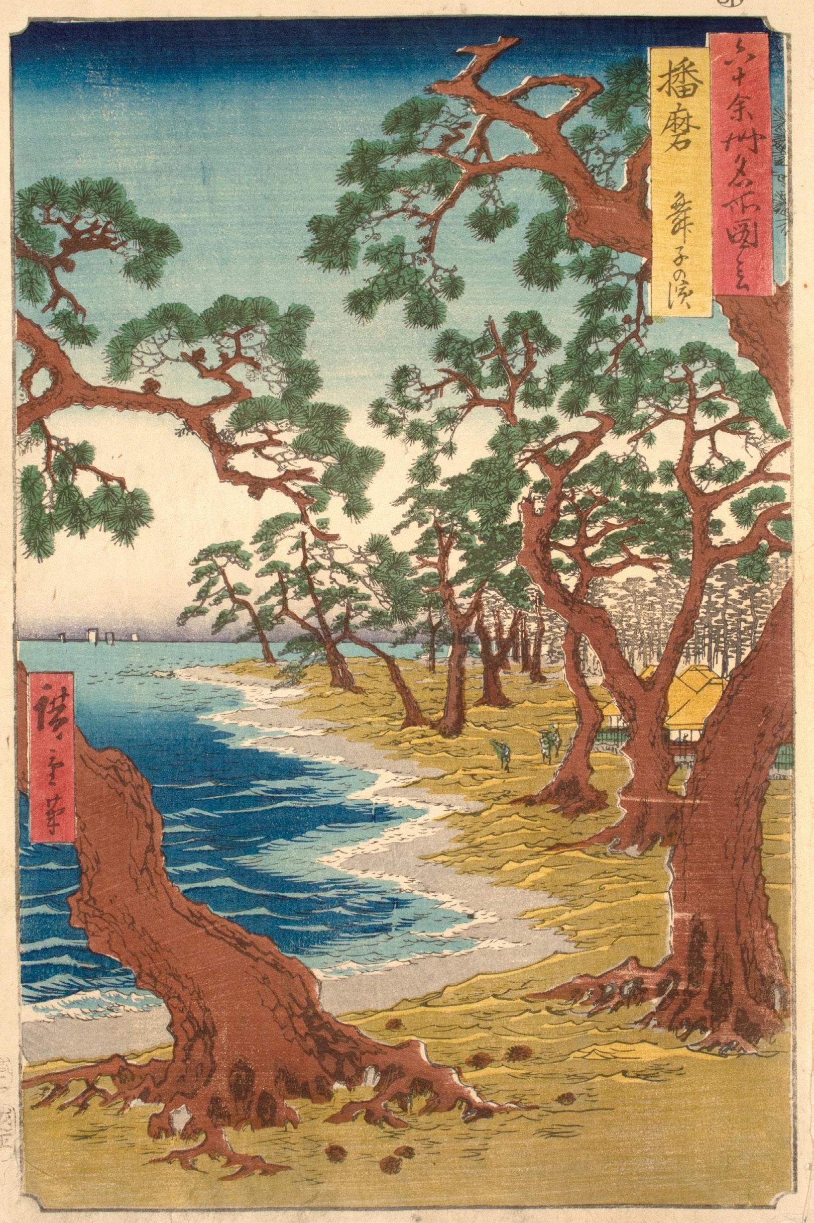
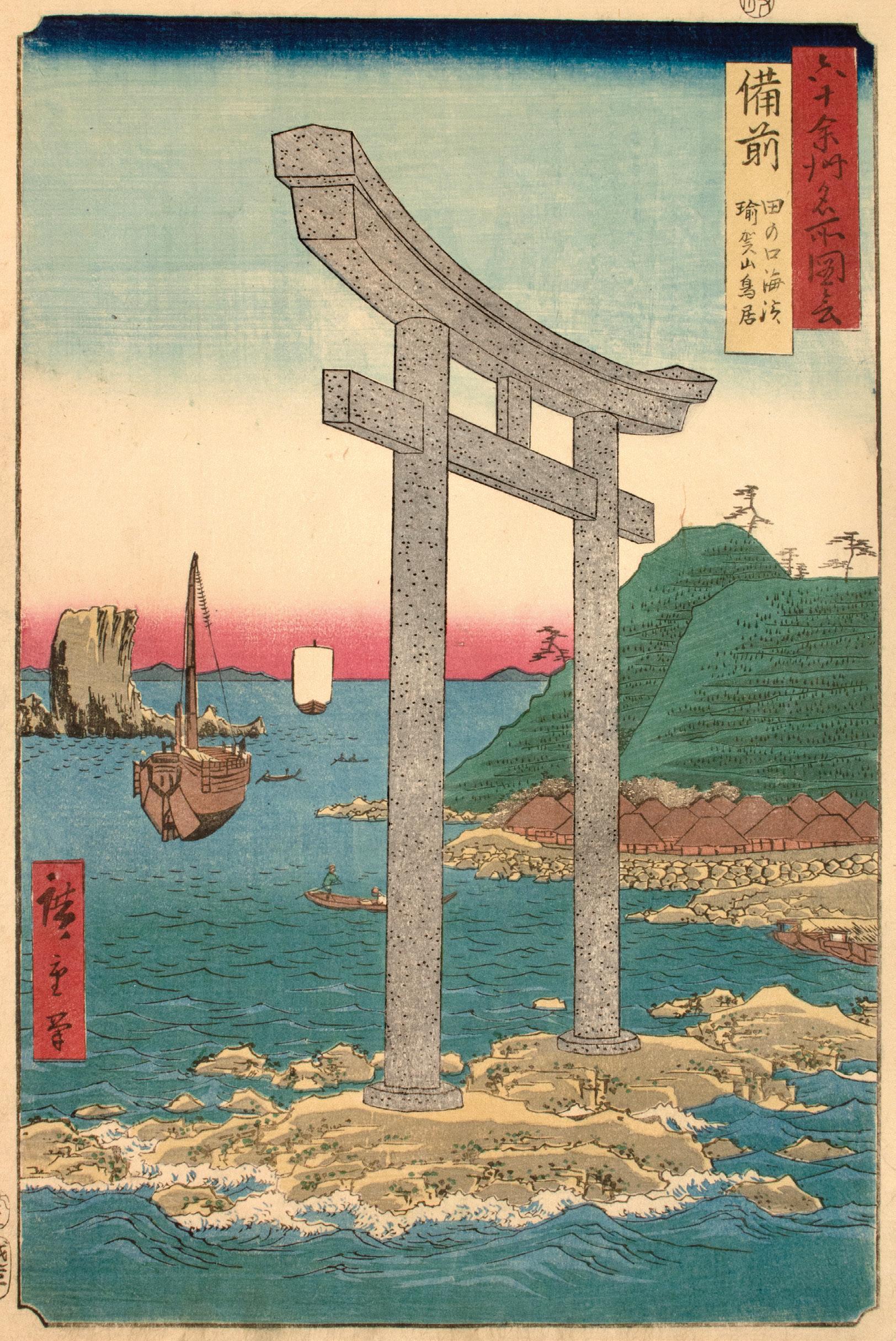
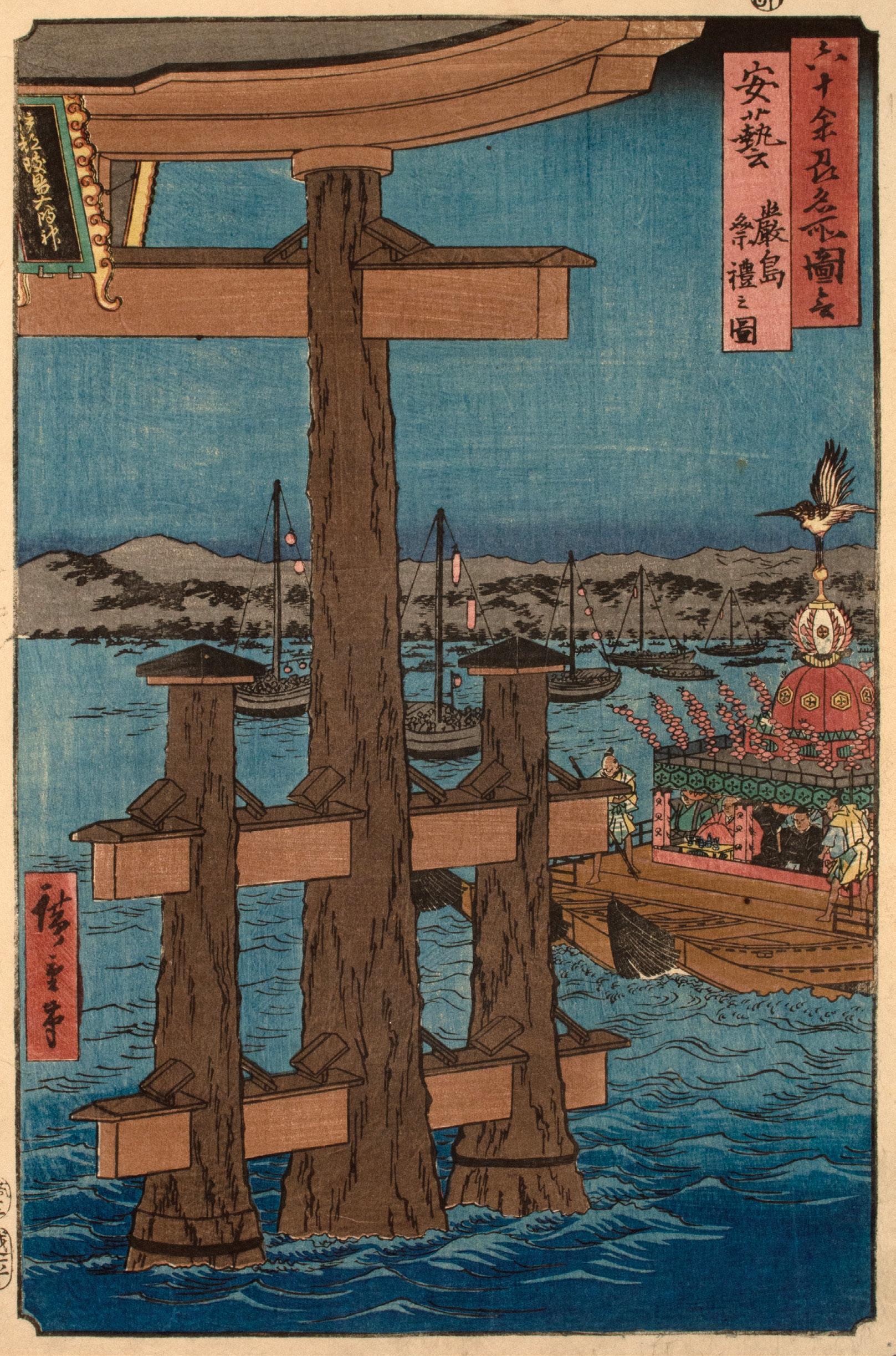
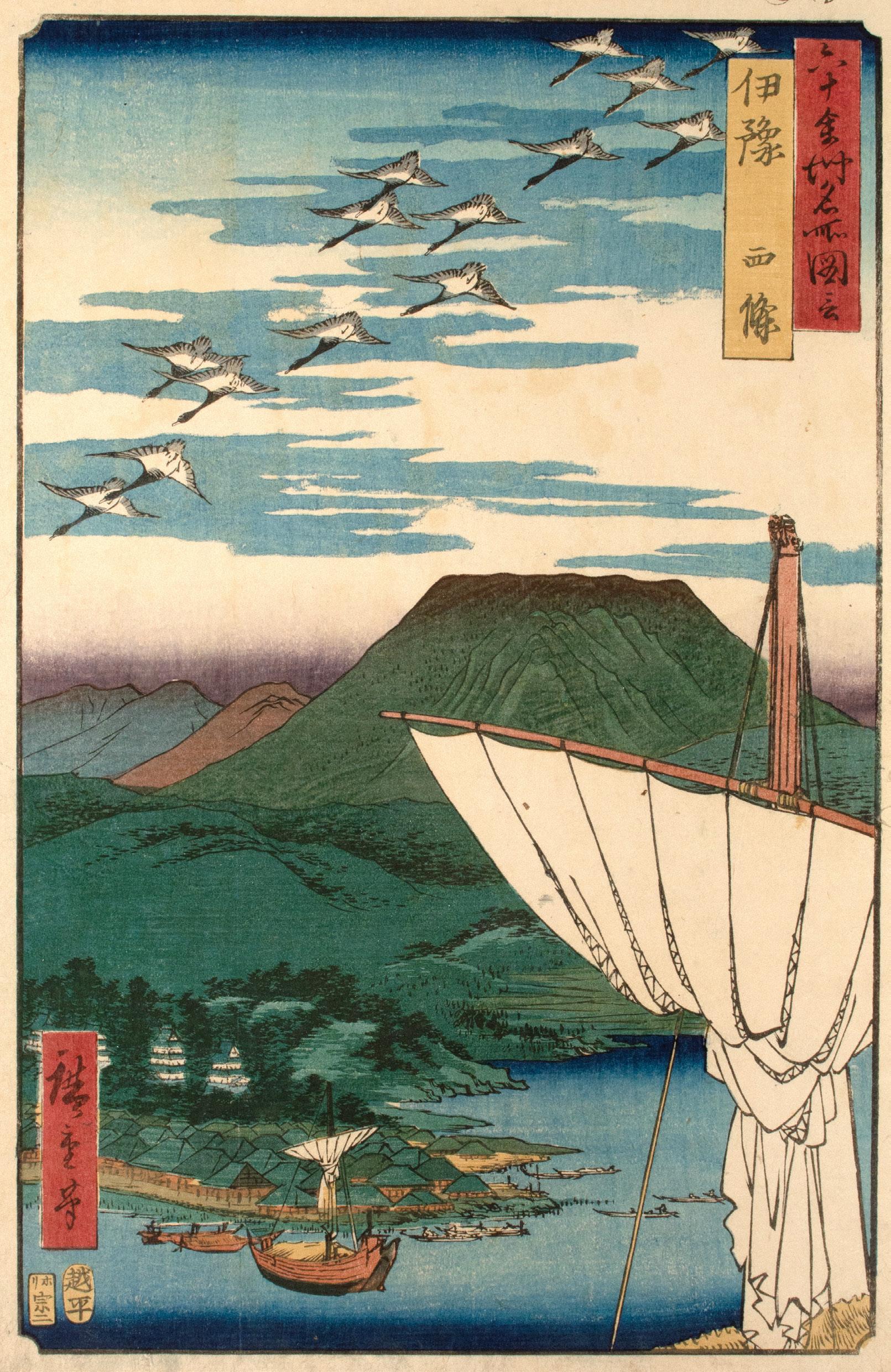
From cherry blossoms to autumn leaves, snowy nights to windswept afternoons, 60-odd Provinces evokes a sense of monumentality though Hiroshige’s elevated, distant viewpoints, abbreviated figures, and embrace of the vertical orientation. While Hiroshige’s journey along the Tokaido is grounded in its travelers, the distant vantage point of 60-odd Provinces reduces human figures to small, compositional elements rather than empathetic characters. As Hiroshige breaks from his typical horizontal format, the elongated space expands the range of vision. It has been suggested that Hiroshige’s embrace of the vertical landscape format may have been inspired by a commission of hundreds of painted vertical landscape scrolls for a regional lord during the 1840s.21 Within each vertical frame of 60-odd Provinces, Hiroshige emphasizes a sense of distance with both small, far-flung forms—such as horizon-bound sails and tree-peppered mountain peaks—and elements of one-point perspective, as seen in the receding shoreline in Harima Province. Hiroshige further defines pictorial space through abruptly truncated objects in the foreground, a technique that would feature heavily in the series 100 Famous Views of Edo. This technique can be seen in the sails in Hizen Province and Iyo Province, or the torii in Aki Province. While Famous Places in the 60-odd Provinces is a triumph of the landscape genre through composition alone, it is also a fine example of the magic achieved in the union between an artist’s design and an artisan’s skill.
Ukiyo-e prints are often described as the work of a single artist, but in truth, each design is the result of the joint effort of the ‘ukiyo-e quartet’—the artist, engraver, printer, and publisher. The artist designs an image that is then pasted onto a finely prepared cherry woodblock. The engraver follows the artist’s lines with a sharp knife, skillfully hollowing out the intervening spaces. Once carved, the key block is a work of art in and of itself. This block is then inked with sumi (black ink) and a sheet of dampened mulberry paper is laid upon it. The printer rubs the paper with a baren (flat circular pad) until the impression is uniformly transferred. This key block impression establishes the design’s outlines and the kento (guide marks) used to align each subsequent color. For a color print, the artist roughly indicates the color scheme, and a separate block is carved for each hue. The printer layers each color atop the key block impression. When the printing is complete, the publisher distributes the finished work to eager audiences and commissions new designs. While Hiroshige imbues 60-odd Provinces with compositional brilliance, the series also speaks to the skill of the carver and printer. Through the hand of the carver, Hiroshige’s lines retain their flowing character in the hard surface of the wood. Some designs in the series include not only the artist’s signature, but also that of the carver, such as Yokokawa Takejiro or Sugawa Sennosuke—perhaps a testament to the pride in the craftsmanship of the series. Upon inking the blocks of the carver, the printer lends texture and mood to the print through color. The use of bokashi (color gradation) adds to the atmosphere of a design, from the evening blush of sunset to the deepest midnight, and lends a solidity of form to the topography— from the swirling depths of whirlpools to the shadows of hewn gold mines. As this is a manual process performed by the printer, no two examples of bokashi will look the same. In addition to bokashi and layered colors, the printer further lends texture to a print through
kimetsubushi (uniform woodgrain printing). By abrading the color block with stiff brushes or pads, the printer could impress the pattern of the woodgrain onto a print. This technique can typically be found in expanses of sky or water. Between Hiroshige’s sweeping compositions, lyricism of season, time, and weather, and the talented hands of the carver and printer, 60-odd Provinces represented the height of the meisho-e genre and technical potential of the woodblock print as a new political landscape broke the horizon.
By the time Hiroshige completed Famous Places in the 60-odd Provinces in 1856, the sense of economic and political stability that shaped Edo-period culture had begun to feel uncertain. In 1854, the shogun agreed to trade with the United States, following the gunboat diplomacy of Commodore Perry. A year later, the city and its spirit were severely damaged through a great earthquake and resulting fires. In 1858, Hiroshige died during a cholera outbreak.22 He received a funeral appropriate to his samurai rank and was buried at Togaku-ji, a Zen temple in the Adachi Ward.23 The following year, the opening of Yokohama would allow an unprecedented surge of foreigners into Japan. Within a decade, the name Edo would fade with the rule of the shogunate. As the imperial line regained power, the city was renamed Tokyo. In 1871, even geographic boundaries shifted as the provinces were restructured into a prefectural system. Hiroshige’s world had changed beyond recognition as the 19th century drew to a close.
Though the world he depicted vanished soon after his death, Hiroshige’s legacy only grew stronger in his wake. Over the course of his career, it is estimated that he produced around 4500 unique designs, and over 120 illustrated books.24 Hiroshige’s legacy proved influential beyond Japan. Exposure to ukiyo-e introduced Western artists to a new visual vocabulary, a fresh conception of space, form,
and color. From Claude Monet and Vincent van Gogh, to Henri de Toulouse-Lautrec and James McNeil Whistler, Hiroshige’s diagonal lines, flat planes of color, fresh perspectives, and dramatic truncation of objects heralded a new approach to composition. Many artists both collected and found inspiration in Hiroshige’s work. In fact, in Whistler’s 1864 painting Caprice in Purple and Gold: The Golden Screen, the model Joanna Hiffernan gazes at a print from Whistler’s private collection, “Osumi Province, Sakurajima” from the 60odd Provinces. Perhaps the Irish model was not the audience that Hiroshige expected, but the print invites her on a journey through the provinces all the same.25
In an unfinished drawing manual Hiroshige wrote, “…to depict a beautiful view the artist must know how to combine with one another each of the elements that constitute that view.”26 Here he refers to not only form and style, but also meaning. In Hiroshige’s Famous Places in the 60-odd Provinces, the elements that define “a view” go far beyond cliffs, rivers, and peaks, beyond the shrines and temples of note. The views offered by this series are infused with the values of the floating world, the culture of travel, and the visual vocabulary of ukiyo-e. Through the language of landscape, Hiroshige extends the pleasure-driven travel culture of 19thcentury Edo much farther beyond the horizon than he could have ever imagined.
Forrer, Matthi, Juzo Suzuki, and Henry D. Smith. Hiroshige: Prints and Drawings. Munich: Prestel, 1997.
Goree, Robert. “The Culture of Travel in Edo-Period Japan.” Oxford Research Encyclopedia of Asian History. 19 Nov. 2020; Accessed 31 Jan. 2023.
Jansen, Marije. Hiroshige’s Journey in the 60-Odd Provinces. Amsterdam: Hotei Publishing, 2004.
Marks, Andreas. Hokusai: 36 Views of Mt. Fuji. Taschen, 2021.
---. Publishers of Japanese Woodblock Prints: A Compendium. Leiden: Hotei Publishing, 2011.
Narazaki, Muneshige. Masterworks of Ukiyo-e: Hiroshige: Famous Views. Tokyo: Kodansha International, 1968.
Newland, Amy Reigle, et al. “Diversification and Further Popularization of the Full-Colour Woodblock Print, c. 1804-68.” Essay. In The Hotei Encyclopedia of Japanese Woodblock Prints, 187–220. Amsterdam: Hotei Publishing, 2005.
Suzuki, Juzo, and Jun’ichi Ookubo. Paysages Célèbres des Soixante Provinces du Japon: Collection Pulverer. Translated by Lachaud François. Paris: Hazan, 1998.
Uhlenbeck, Chris, and Marije Jansen. Hiroshige: Shaping the Image of Japan. Leiden: Hotei Publishing, 2008.
White, Julia M., Reiko Mochinaga Brandon, Yoko Woodson, and Shuzo Uemoto. Hokusai and Hiroshige: Great Japanese Prints from the James A. Michener Collection, Honolulu Academy of Arts. San Francisco, CA: Asian Art Museum of San Francisco in association with the Honolulu Academy of Arts and University of Washington Press, 1998.
Witkam, Frank. “Reflections of reality: Scenic 19th-century views of Nikko,” Andon 109 (Spring 2020): 48-72.
TOSANDO
1. Yamashiro
2. Yamato
3. Kawachi
4. Izumi
5. Settsu
22. Omi
23. Mino
24. Hida
25. Shinano 26. Kozuke
27. Shimotsuke
28. Mutsu
29. Dewa
TOKAIDO
6. Iga
7. Ise
HOKURIKUDO
Wakasa
54.
55.
59. Chikuzen
60. Chikugo
61. Buzen
62. Bungo
63. Hizen
64. Higo
65. Hyuga
66. Osumi
67. Satsuma
68. Iki
69. Tsushima
Title Page
Artist: Baisotei Genyo
Date: 1856
Medium: Woodblock print

Size: 14.25” x 9.75”
Publisher: Koshimuraya Heisuke
Signature: Gengyo ga
Designed by Baisotei Gengyo (18171880), this title page was included in albums of Famous Places in the 60-odd Provinces released between 1856 and 1858. Printed in brilliant red, the title cartouche reads “Series of Famous Places in the 60-odd Provinces of Japan, Ichiryusai Hiroshige.” The provinces are grouped in decorative cartouches by the eight-region system known as the gokishichido. These include the region of the five provinces around the imperial capital of Kyoto ( gokinai) and the seven regions around Japan’s ancient highways (shichido): the Tokaido, Tosando, Hokurikudo, Sanindo, Sanyodo, Nankaido, and Saikaido. In the first release of the album, the provinces of Bungo and Buzen were omitted from the Saikaido. This mistake was later corrected with a plug in the block.1 The small red cartouche in the bottom identifies the publisher, Koshimuraya Heisuke, and the date, 1856.
Date: 1853
Medium: Woodblock print
Size: 14.5” x 10.75”
Publisher: Koshimuraya Heisuke
Carver: Yokokawa Takejiro
Signature: Hiroshige hitsu
Measuring over 150 meters long, Togetsu Bridge stretches across the Katsura River as the mountains beyond bloom with cherry blossoms. Located in the hills of western Kyoto, Arashiyama is known for its natural beauty. Blushing pink in the spring and ablaze in reds, oranges, and yellows each fall, Arashiyama attracts those in search of seasonal beauty. This landscape has inspired writers, poets, and artists alike across the centuries. Today, the former Yamashiro Province makes up the southern half of Kyoto Prefecture.

Date: 1853
Medium: Woodblock print
Size: 14.5” x 10.75”
Publisher: Koshimuraya Heisuke
Carver: Yokokawa Takejiro
Signature: Hiroshige hitsu
Far below the boughs of auburn leaves, boats make their way down the Tatsuta River. On the left bank, Hiroshige’s raised viewpoint reduces the houses to small roofs beneath the groves of maple and pine. Known for its brilliant fall foliage, the area around Horyu Temple was a famous spot for maple leaf viewing (momijigari). This seasonal practice remains popular in Japan today, attracting domestic and international tourists alike. The former Yamato Province is part of modern Nara Prefecture.

3.
Date: 1853
Medium: Woodblock print
Size: 14.25” x 9.75”
Publisher: Koshimuraya Heisuke
Carver: Yokokawa Takejiro
Signature: Hiroshige hitsu
As the Yodo River curves below, the rugged peak of Mount Otoko breaks through the clouds. Mount Otoko was home to Iwashimizu Hachimangu Shrine, one of Japan’s most important Shinto sites and a popular pilgrimage destination. The use of bokashi (color gradation) infuses the scene with a rich atmosphere. From the pink and purple of the clouds to the blue horizon and the yellow sky, the soft, graduated shades evoke the light of dusk. Meanwhile, the overprinted grey on the mountain peaks promises imminent nightfall. Today, the former Kawachi Province is part of eastern Osaka Prefecture.

Date: 1853
Medium: Woodblock print
Size: 14.5” x 10.25”
Publisher: Koshimuraya Heisuke
Carver: Yokokawa Takejiro
Signature: Hiroshige hitsu
Travelers follow the well-worn path to Takashi Shrine in the foreground as Osaka Bay stretches to the horizon. Far below the pine-covered slope, the waves lap against Takashi Beach, one of many religious sites along the coast. In this impression, the use of kimetsubushi (uniform woodgrain printing) lends texture to the expansive blue of Osaka Bay. The printer achieved this effect by roughening the color block with stiff brushes or pads before inking its surface. The former Izumi Province is now part of southern Osaka Prefecture.
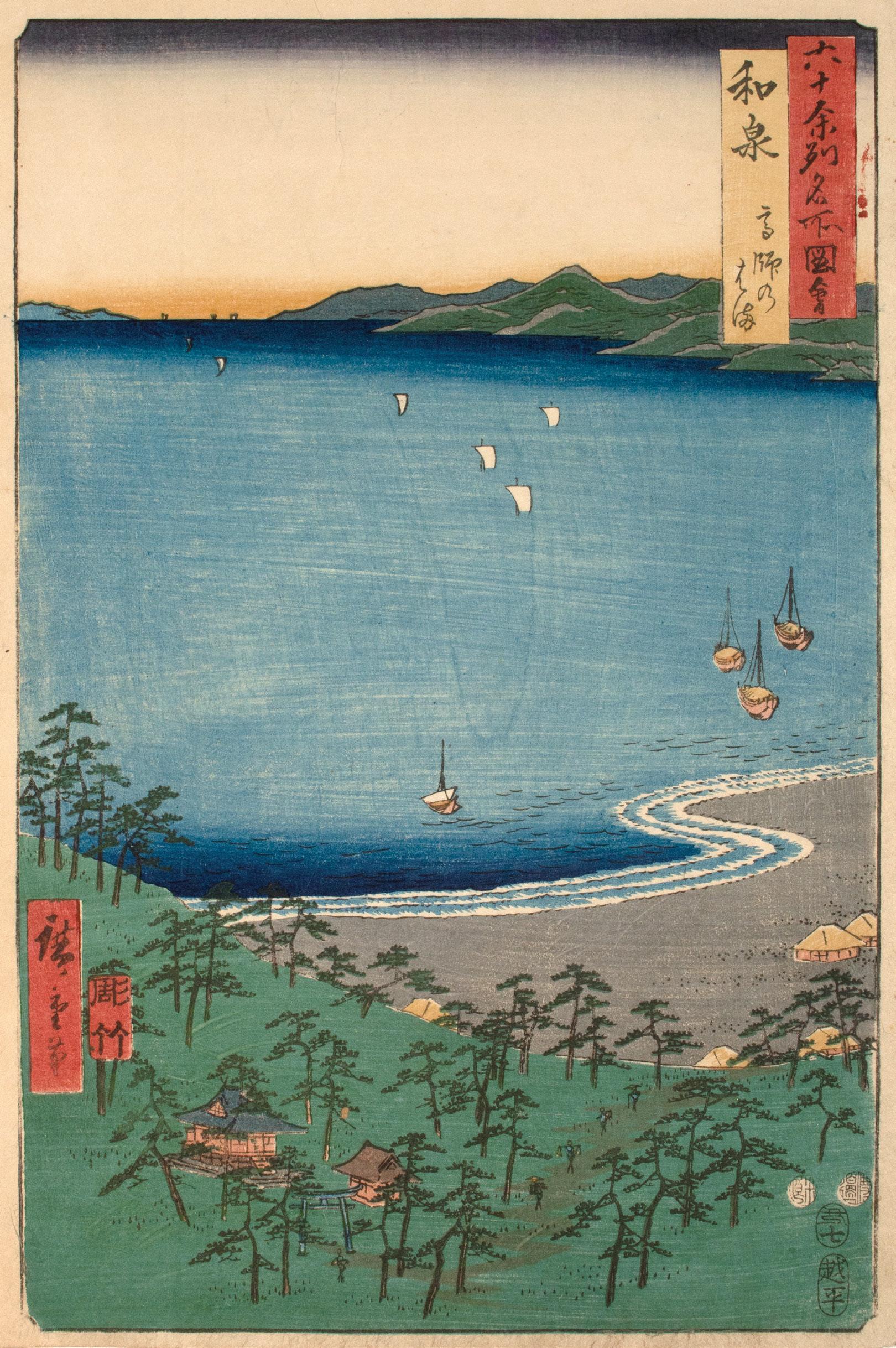
Date: 1853
Medium: Woodblock print
Size: 14.5” x 10.75”
Publisher: Koshimuraya Heisuke
Carver: Yokokawa Takejiro
Signature: Hiroshige hitsu
Towering above the pines, Japan’s oldest lighthouse guides the ships in Osaka Bay to shore. According to travel guides of the time, this lighthouse was a popular tourist attraction that dated back to the 14th century. The lighthouse was constructed as an offering for the gods of Sumiyoshi Shrine, one of Japan’s oldest Shinto sites. Following a visit to the shrine, travelers could enjoy refreshments at the beachside teahouses of Idemi Beach. A type of sake known as Itami-zake was a local specialty (meibutsu) of this province.2 Today, Settsu Province belongs to southeastern Hyogo Prefecture and northern Osaka Prefecture.

Date: 1853
Medium: Woodblock print
Size: 14.25” x 9.75”
Publisher: Koshimuraya Heisuke
Carver: Hori Ta
Signature: Hiroshige hitsu
Beyond the banks of the Yamato River in the foreground, pale castle walls appear beneath the shadow of the mountain. Built in 1570, Iga Ueno Castle was known for having the highest stone wall in Japan. Many pilgrims traveling from the Nara and Kyoto areas would pass through Ueno on their journey to the Ise Grand Shrine, a popular pilgrimage destination. Historical Iga Province roughly corresponds with the area around the cities of Iga and Nabari in modern Mie Prefecture.
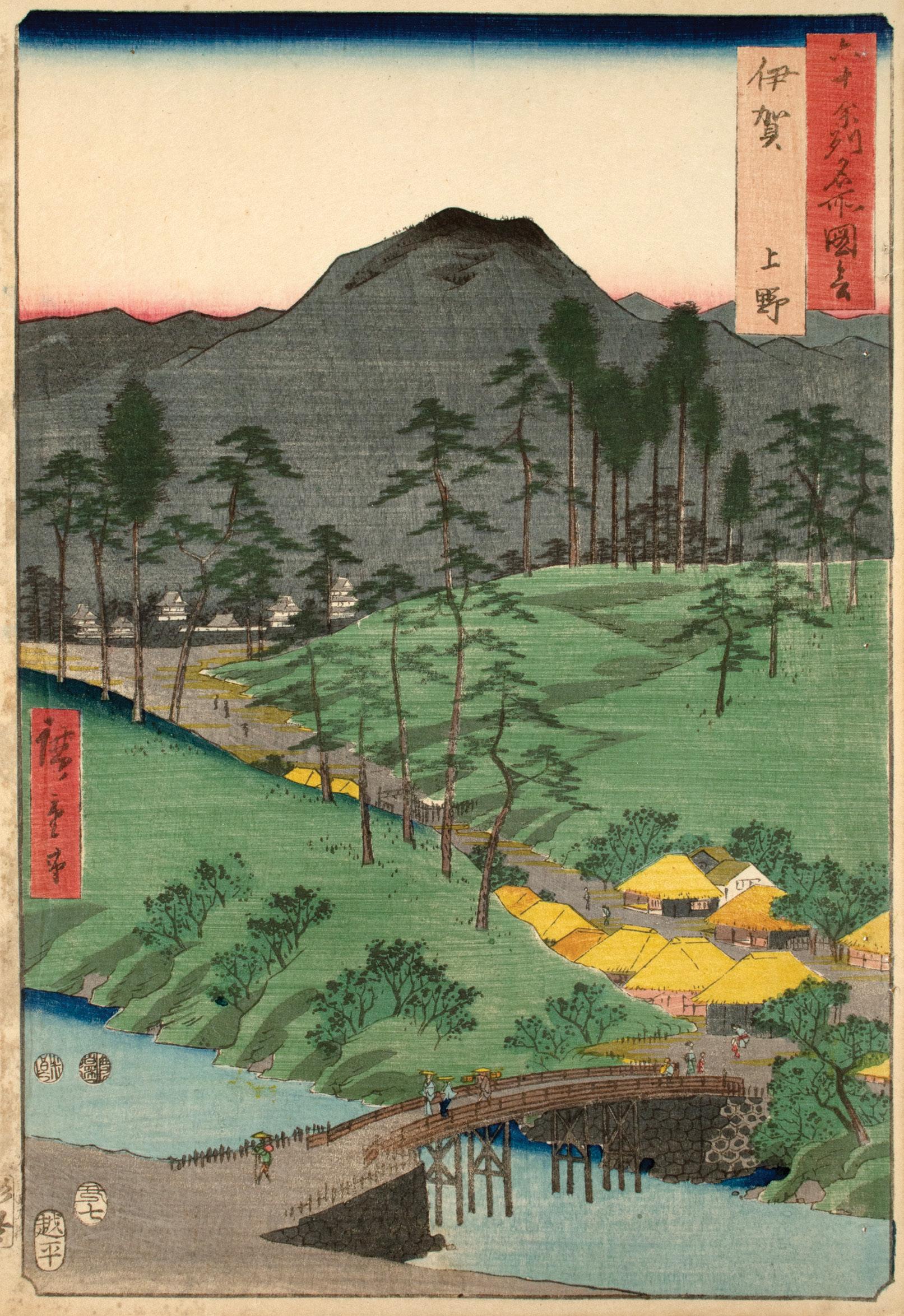
Date: 1853
Medium: Woodblock print
Size: 14.5” x 10.75”
Publisher: Koshimuraya Heisuke
Carver: Hori Ta
Signature: Hiroshige hitsu
Though the mountains that rise above Ise Bay were home to many temples and shrines, Ise Province drew a staggering number of pilgrims to its Ise Grand Shrine. It is said that in 1830 as many as “4.7 million people visited the Great Ise Shrine…over a sixth month period.”3 Dedicated to the sun goddess Amaterasu, this shrine is considered one of Japan’s most sacred Shinto sites. During their visit, pilgrims could enjoy the local specialty (meibutsu) of this province–akafuku mochi. This rice cake (mochi) covered in sweet red bean paste remains a popular souvenir from the area. The former Ise Province now composes much of modern Mie Prefecture.

Date: 1853
Medium: Woodblock print
Size: 14.5” x 10.75”
Publisher: Koshimuraya Heisuke
Signature: Hiroshige hitsu
On the beach of Toba Bay, the town of Toba served as a starting point for many pilgrims venturing to the shrines of Ise Province. Given the topography, the bay provided safe haven for boats during rough weather. While larger ships anchor in the foreground, the white sails of distant boats grow smaller until they disappear into the pink horizon line. Through this diminishing scale, Hiroshige emphasizes the expansiveness of the sea. Shima Province was the smallest of the provinces and today makes up a peninsula of southeastern Mie Prefecture.

Date: 1853
Medium: Woodblock print
Size: 14.5” x 10.75”
Publisher: Koshimuraya Heisuke
Carver: Yokokawa Takejiro
Signature: Hiroshige hitsu
As night settles over the mountains and hills, the Tenno River is illuminated by the hundreds of lanterns decorating the boats of the Tenno Festival. Historically held on the fourteenth and fifteenth days of the sixth month on the lunar calendar, the sailing of the illuminated boats was a highlight of the celebration. Each year, temporary teahouses sprung up on the riverbank to cater to the crowds drawn by the festival. Today, the Tenno Festival is designated as a National Important Intangible Folk Cultural Asset and held in July. The former Owari Province composes the western half of modern Aichi Prefecture, including the city of Nagoya.
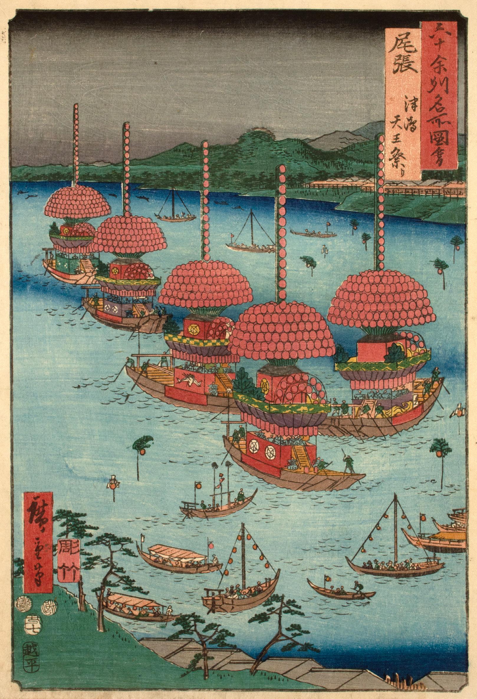
10.
Mikawa Province, Horai Temple Mountains
Date: 1853
Medium: Woodblock print
Size: 14.5” x 10.75”
Publisher: Koshimuraya Heisuke
Carver: Yokokawa Takejiro
Signature: Hiroshige hitsu
Hiroshige evokes a sense of altitude in the steep Horai Mountains as the waterfall weaves through the heavy clouds and the temple stairs extend beyond the top margin. Nestled throughout the rugged mountainside, Horai Temple is a Shingon Buddhist temple. During the Edo period, it was a popular pilgrimage site along the Tokaido. From the main crimson gate, visitors could climb the 1425 steps to the main temple. Today, the former Mikawa Province composes the eastern half of modern Aichi Prefecture.
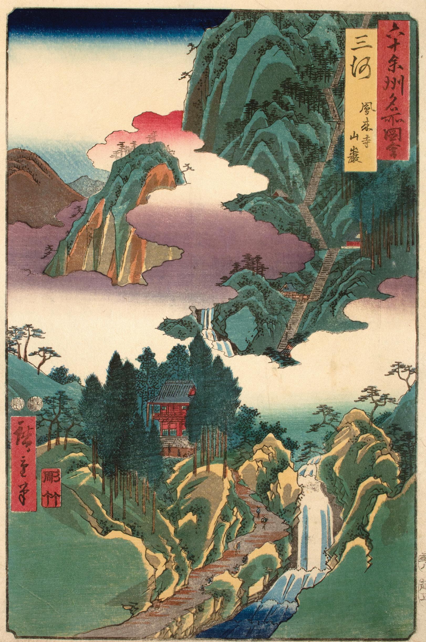
11. Totomi Province, Lake Hamana, Kanzan Temple in Horie and the Inasa-Hosoe Inlet
Date: 1853
Medium: Woodblock print
Size: 14.5” x 10.75”
Publisher: Koshimuraya Heisuke
Carver: Yokokawa Takejiro
Signature: Hiroshige hitsu
As the roofs of Kanzan Temple peek out above the canopy of a pine grove, the inlet cuts across the foreground. To follow the meandering curve of sand would lead one to the open water of Lake Hamana. This print offers a fine example of kimetsubushi (uniform woodgrain printing) in the water of Lake Hamana. For this printing technique, the color block for the water was roughened with stiff brushes or pads to bring out the natural grain of the wood. As blocks were printed over and over, the sharp lines of the woodgrain would become less apparent with each subsequent impression. The historical Totomi Province belongs to western Shizuoka Prefecture.

Date: 1853
Medium: Woodblock print
Size: 14.25” x 9.75”
Publisher: Koshimuraya Heisuke
Carver: Yokokawa Takejiro
Signature: Hiroshige hitsu
Cloaked in the pink and purple clouds of dusk, Mount Fuji towers over Suruga Bay as Miho Pine Grove stretches out into the water. Added to the UNESCO World Heritage List in 2013, this waterside grove is the site of the legend of Hagoromo (The Feathered Robe). The story tells of a fisherman who finds the feathered robe of a heavenly being hanging on a pine bough. Without it she cannot return to heaven, so she performs a dance for the fisherman in exchange for her robe. Today, the former Suruga Province is part of central Shizuoka Prefecture. Both then and now, green tea has been a popular local specialty (meibutsu) of this region. 4

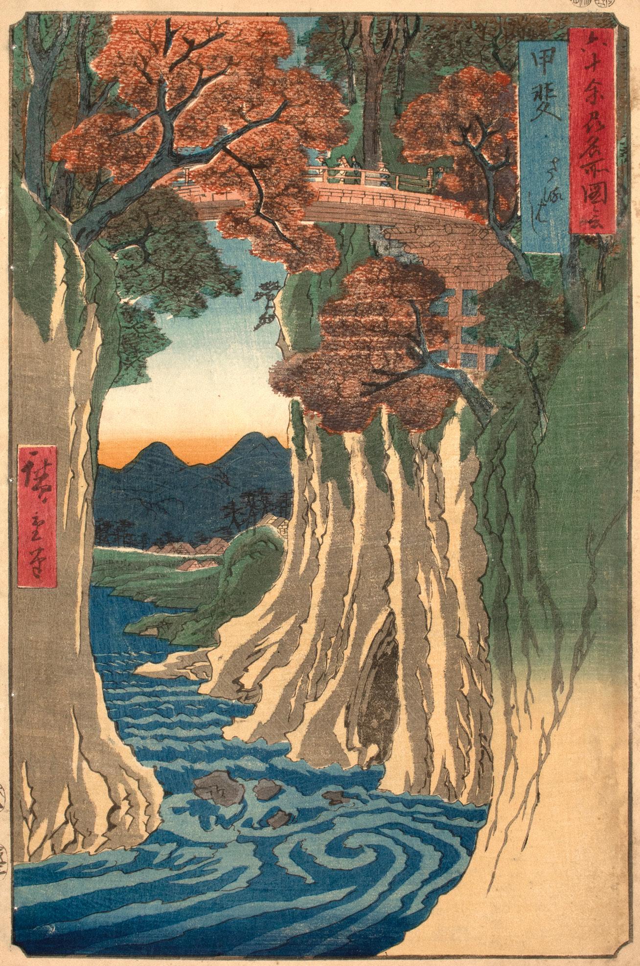
13. Kai Province, Monkey Bridge
Date: 1853
Medium: Woodblock print
Size: 14.25” x 9.75”
Publisher: Koshimuraya Heisuke
Signature: Hiroshige hitsu
Far above the Katsura River, travelers cross through a canopy of autumn leaves on the Monkey Bridge. Through abbreviated figures and a low vantage point, Hiroshige emphasizes the height of the bridge as well as the wonder of its construction. In a design known as hanebashi, cantilever beams are set in the opposing cliff faces to support the bridge above. The Monkey Bridge is considered one of Japan’s most famous bridges and can still be visited today. Though Hiroshige likely relied on the accounts of others for many sites in this series, it is thought that he experienced this famous bridge firsthand in 1823.5 The former Kai Province is part of modern Yamanashi Prefecture.
5. According to a diary that is now lost. Jansen, Hiroshige’s Journey in the 60-
Date: 1853
Medium: Woodblock print

Size: 14.25” x 9.75”
Publisher: Koshimuraya Heisuke
Carver: Yokokawa Takejiro
Signature: Hiroshige hitsu
First discovered by a monk in the 9th century, the hot springs of Shuzen Temple continue to be a popular destination in Izu Province. Located not far from Edo, the many bathhouses around the hot springs offered travelers a relaxing visit and a legitimate reason for travel: medical care. A 21-day stay at an onsen (hot springs) was considered a cure to some ailments and thus an approved reason for travel.6 Some impressions of this design show a small misprint of a green color block on the center of the right bank. Today, the former Izu Province is part of modern Shizuoka Prefecture.
15. Sagami Province, Enoshima, The Entrance to the Caves
Date: 1853
Medium: Woodblock print

Size: 14.5” x 10.75”
Publisher: Koshimuraya Heisuke
Carver: Yokokawa Takejiro
Signature: Hiroshige hitsu
As Mount Fuji rises beyond the left margin, waves crash against the rugged shore of Enoshima. Beneath the lush green of the cliffs above, the cave entrance in the lower right invites the viewer into the darkness. Hewn by the waves over time, this cave system housed a shrine to Benzaiten, a goddess associated with fortune and artistic success. The caves attracted many pilgrims, and the entire island was considered a sacred site. In addition to the usual travelers, this small island attracted many celebrities and ambitious individuals of the floating world. Today, Enoshima is a popular date spot. The former Sagami Province composes western and central Kanagawa Prefecture.
16.
Date: 1853
Medium: Woodblock print
Size: 14.5” x 10.75”
Publisher: Koshimuraya Heisuke
Signature: Hiroshige hitsu
The Sumida River is quiet as the morning glow blushes above a blanket of snow. As few boats take to the river in the chill, a trio of small birds float on the calm water. In the foreground, Matsuchiyama Shoden Honryu Temple rises from the snow on the right bank, while the canal to its left leads from the Sumida River to the Shin Yoshiwara, Edo’s legalized pleasure district. Though Musashi Province belongs to modern Tokyo Metropolis, Hiroshige’s tranquil winter scene offers no hint of the bustling city we know today. In addition to Tokyo, the former Musashi Province belongs to part of modern Kanagawa Prefecture and Saitama Prefecture.

Date: 1853
Medium: Woodblock print
Size: 14.5” x 10.75”
Publisher: Koshimuraya Heisuke
Carver: Hori Kosen
Signature: Hiroshige hitsu
The city of Edo is the only design in the series to break from the provincial classification. Beneath a starry sky and bare branches, throngs of celebrants pack the space in front of Asakusa Kannon Temple. Eyeing everything from battledores to baskets, visitors explore the crowded stalls of this year-end fair. Hiroshige balances the activity in the lower half of the composition through the stark crimson architecture that breaks through the clouds. The city of Edo, home to Hiroshige and the floating world, is today modern Tokyo.

18.
Awa Province, Kominato, Uchiura
Date: 1853
Medium: Woodblock print
Size: 14.5” x 10.75”
Publisher: Koshimuraya Heisuke
Carver: Yokokawa Takejiro
Signature: Hiroshige hitsu
In Awa Province, the mountain path gives way to a stunning view of Uchiura Bay. As the roofs of Uchiura Village rest just beneath the mountain path, the village of Kominato hugs the far beach. In the distant foothills, Tanjo Temple rises above the treetops. This famous temple was built in honor of Nichiren, the monk who founded the Nichiren sect of Buddhism in the 13th century. Though there are two provinces pronounced “Awa” in this series, they were two distinct provinces whose names were written with different kanji. In spoken conversation these provinces would have been referred to by their colloquial names—Ashu and Boshu. Today, the former Awa Province is part of Chiba Prefecture.

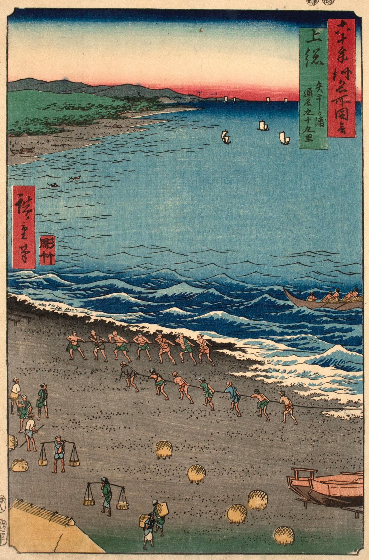
19. Kazusa Province, Yazashi Bay, Common name: Kujukuri
Date: 1853
Medium: Woodblock print
Size: 14.5” x 10.75”
Publisher: Koshimuraya Heisuke
Carver: Yokokawa Takejiro
Signature: Hiroshige hitsu
Known by the nickname “99-mile” (Kujukuri), the coast of Yazashi Bay spanned the entire western coast of Kazusa Province. Since this area was known for its variety of seafood, it is no surprise that Hiroshige focuses on the beachside activities of the fishermen in this design. As teams of men seven strong pull in the nets, others wait on the sand with baskets in hand, ready to transport the catch of the day. In some impressions of this design, kimetsubushi (uniform woodgrain printing) is visible in the grey of the beach, lending texture to the sand. Today, the former Kazusa Province is part of Chiba Prefecture.
Date: 1853
Medium: Woodblock print
Size: 14.25” x 9.75”
Publisher: Koshimuraya Heisuke
Signature: Hiroshige hitsu
As the snow-covered peak of Mount Fuji breaks the horizon of Byobu Bay, a group of travelers look upon Thousand Calvary Rock (Senki ga iwa) from the beach.7 Natural wonders, such as unusual rock formations like this one, attracted sightseers during the Edo Period. This type of natural tourism aided the local economy as visitors hired locals as guides. Today, the former Shimosa Province is part of both Chiba Prefecture and Ibaraki Prefecture.

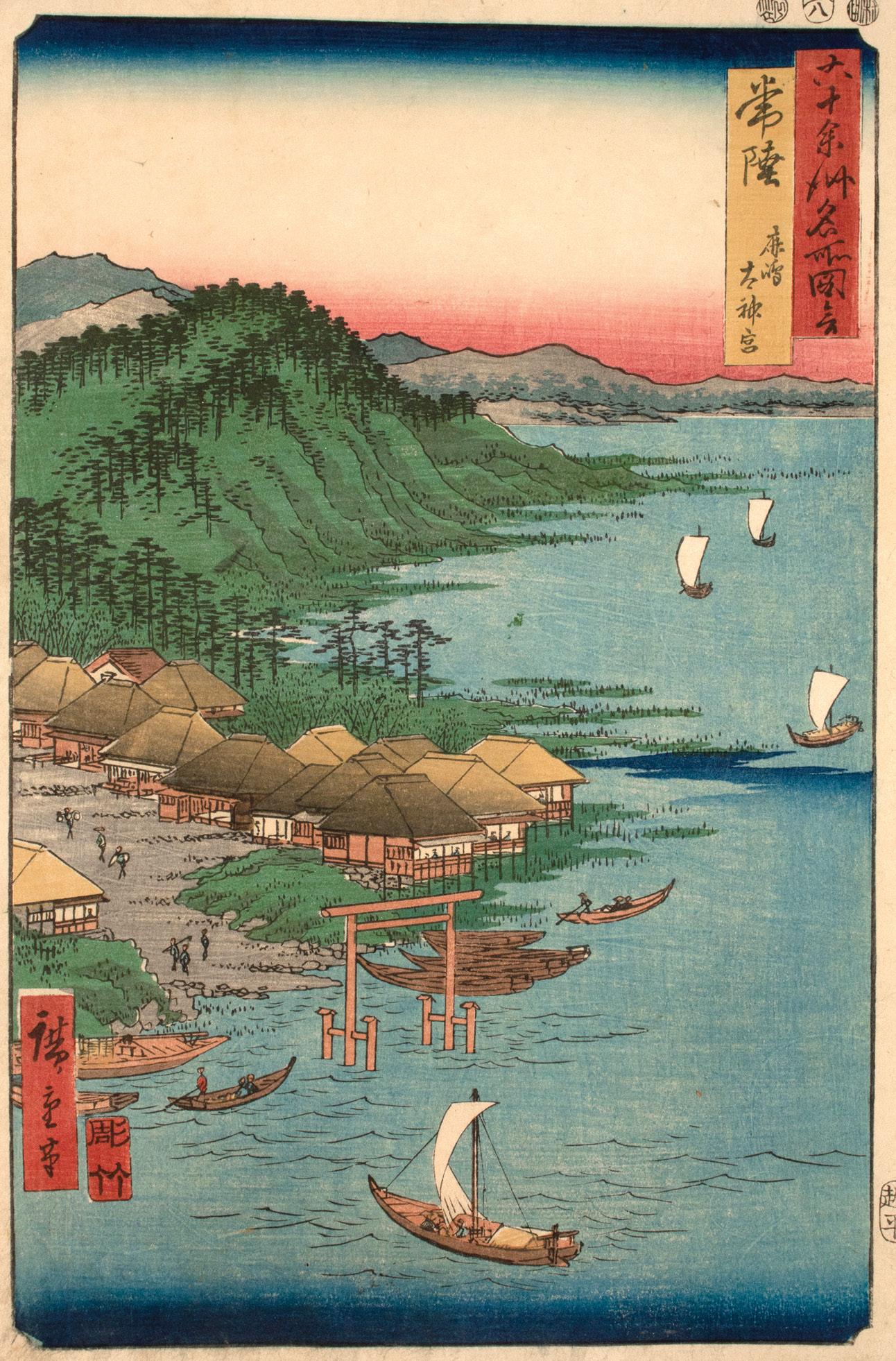
21. Hitachi Province, Kashima Grand Shrine
Date: 1853
Medium: Woodblock print
Size: 14.5” x 10.75”
Publisher: Koshimuraya Heisuke
Carver: Yokokawa Takejiro
Signature: Hiroshige hitsu
Against a backdrop of distant mountains, a torii rises from Lake Kita to mark the grounds of Hitachi Province’s most sacred Shinto site. Dedicated to Takemikazuchi, deity of imperial strength and military prowess, the Grand Kashima Shrine (Kashima Daijingu) typically welcomed visitors from Edo by boat. Upon disembarking, they’d follow the path to the shrine, perhaps stopping by one of the many teahouses along the way for a refreshment. Today, the former Hitachi Province is part of Ibaraki Prefecture.
Date: 1853
Medium: Woodblock print
Size: 14.5” x 10.75”
Publisher: Koshimuraya Heisuke
Carver: Yokokawa Takejiro
Signature: Hiroshige hitsu
Beneath the light of the full moon, the landscape along the Seta River slumbers in shades of grey. As Mount Ibuki peaks in shadow to the upper right of the scene, the warm glow of riverside teahouses beckons in the foreground. Though Hiroshige does not depict Ishiyama Temple itself, the teahouses mark the periphery of the temple grounds. The use of black bokashi (gradation) along the top edge emphasizes the depth of night. The printer achieved this gradation by brushing color on the dampened woodblock then printing it onto the paper. Today, the former Omi Province belongs to Shiga Prefecture.

23. Mino Province, Yoro Waterfall
Date: 1853
Medium: Woodblock print
Size: 14.25” x 9.75”
Publisher: Koshimuraya Heisuke
Carver: Yokokawa Takejiro
Signature: Hiroshige hitsu
Cascading off Mount Yoro, Yoro Waterfall was a natural meisho (famous place) of Mino Province. In this striking composition, Hiroshige evokes a sense awe, perhaps as profound as that felt before the actual waterfall. At first glance, the eye is drawn to the column of blue and white down the length of the page. After a moment, the overhanging pines establish a sense of scale, while the blushing clouds suggest a staggering height. Finally, in the white of the cascade, the use of karazuri (blind printing) adds texture to the water, embossing the paper and suggesting movement. Yoro Waterfall remains a tourist destination today. The former Mino Province now belongs to southern Gifu Prefecture.

24. Hida Province, Basket Ferry
Date: 1853
Medium: Woodblock print
Size: 14.25” x 9.75”
Publisher: Koshimuraya Heisuke
Carver: Yokokawa Takejiro
Signature: Hiroshige hitsu
At times, travel required some innovative solutions. High above a rushing river, travelers cross the gorge in a basket ferry. Suspended on anchored lines, the baskets and their riders are carefully ferried through the air by ropes manned on either side. Though Hiroshige depicts the technical details of this rope system, he likely never experienced it himself. Instead, he found these details in the designs of others, perhaps an illustration by his teacher Utagawa Toyohiro in the novel The Legend of the Floating Peony (1809).8 Today, Hida Province belongs to northern Gifu Prefecture.

25. Shinano Province, The Moon Reflected in the Sarashina Paddyfields, Mount Kyodai
Date: 1853
Medium: Woodblock print

Size: 14.25” x 9.75”
Publisher: Koshimuraya Heisuke
Carver: Yokokawa Takejiro
Signature: Hiroshige hitsu
As clouds encircle the base of Mount Kyodai the full moon seems to bounce through the paddy-fields, each watery surface reflecting its likeness in this atmospheric composition. Just above the fields, Choraku Temple sits in the shadow of “Granny Rock.” Wooden combs were a popular local specialty (meibutsu) of this province.9 Today, the former Shinano Province belongs to Nagano Prefecture.
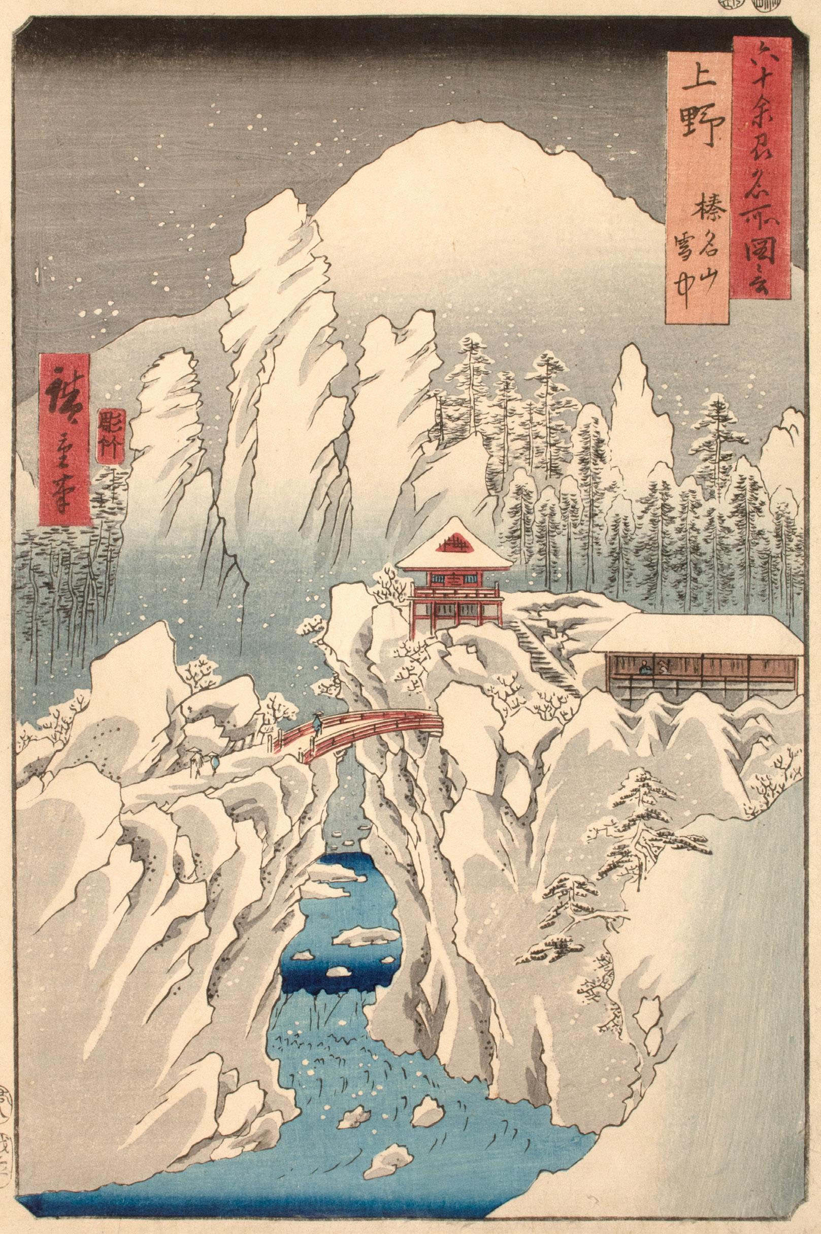
26.
Kozuke Province, Mount Haruna
Under Snow
Date: 1853
Medium: Woodblock print
Size: 14.5” x 10.25”
Publisher: Koshimuraya Heisuke
Carver: Yokokawa Takejiro
Signature: Hiroshige hitsu
Nestled within the snow-covered landscape, the bright red of Haruna Shrine invites the traveler across the gorge. Dedicated to the deities of fire and soil, this Shinto site attracted many pilgrims. Snow continues to fall from the black bokashi (color gradation) of the night sky, weighing down the pine boughs and cloaking the rocks and cliffs in a blanket of white. This design is considered one of the masterpieces of this series. Today, the former Kozuke Province belongs to Gunma Prefecture.
27. Shimotsuke Province, Mount Nikko, Urami Waterfall
Date: 1853
Medium: Woodblock print
Size: 14.25” x 9.75”
Publisher: Koshimuraya Heisuke
Carver: Yokokawa Takejiro
Signature: Hiroshige hitsu
As Urami Waterfall cascades from the clouds, travelers pause in wonder on the narrow path beneath this natural meisho (famous place). While the atmosphere of this design springs from Hiroshige’s mind, the topography was likely inspired by meishoki (travel guides). Many landscape artists relied on the illustrations of others to capture a distant landscape. Hiroshige presents a hewn cliffside path, both common to 19th-century depictions of Urami Waterfall and true to reality. However, occasionally one will see iterations of a wooden bridge, as depicted in Okada Kanrin’s Record of Mount Nikko (1837).10 Today, the former Shimotsuke Province is part of Tochigi Prefecture.

28.
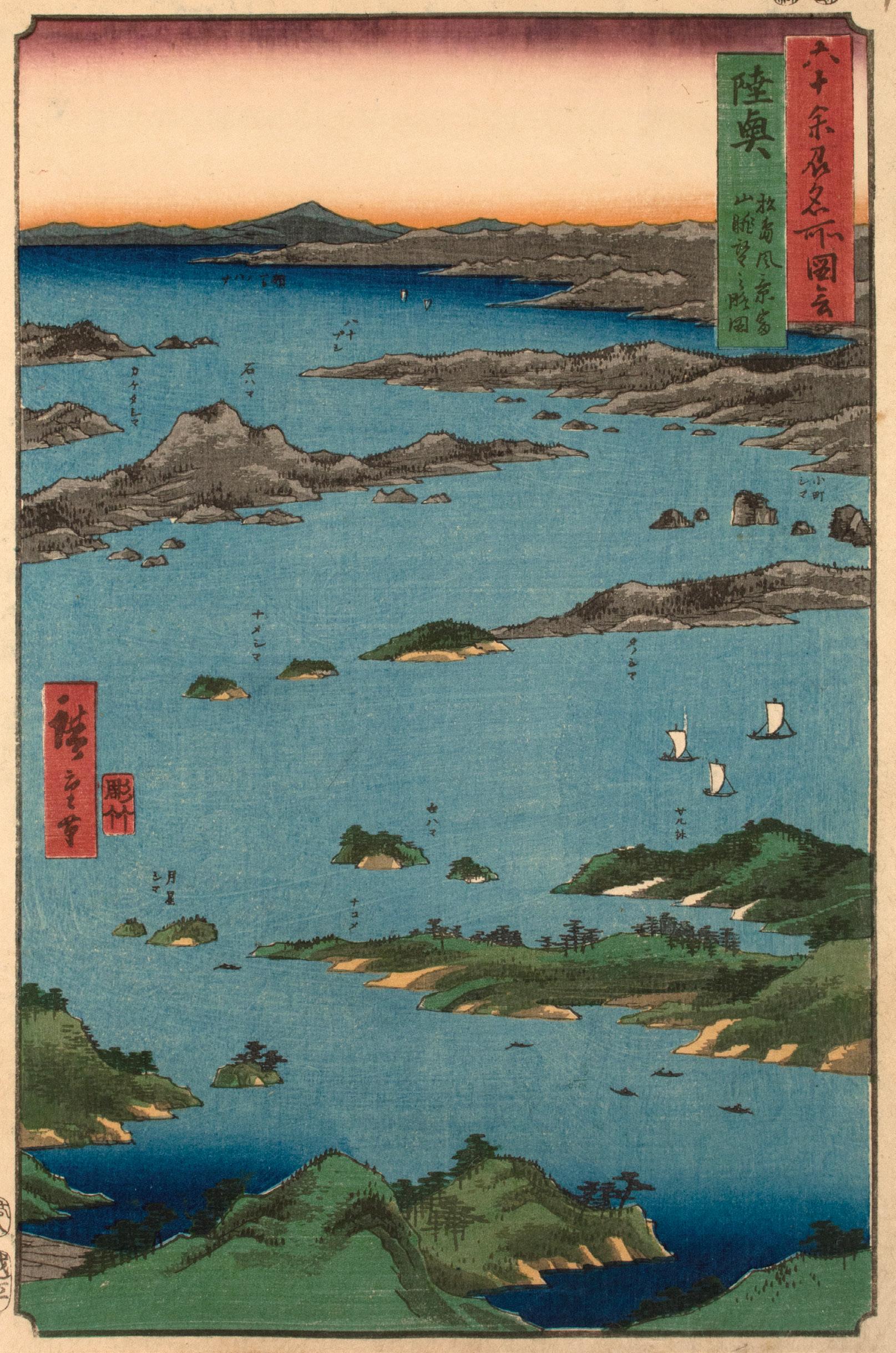
Date: 1853
Medium: Woodblock print
Size: 14.5” x 10.75”
Publisher: Koshimuraya Heisuke
Carver: Yokokawa Takejiro
Signature: Hiroshige hitsu
Known as one of Japan’s “Three Famous Views” (Nihon Sankei), the pine-covered islands of Matsushima appear in miniature from Mount Tomi. This elevated mountain perch is considered the “Beautiful View” (reikan) of the “Four Great Views” of Matsushima. Between this almost aerial viewpoint and the labeled islands, this design evokes the illustrations in the travel guides that inspired Hiroshige’s designs. Today, Matsushima remains a popular tourist location in Miyagi Prefecture. The former Mutsu Province is now split between modern Miyagi, Fukushima, Iwate, Aomori, and Akita Prefectures.
29. Dewa Province, Mogami River, A Perspective View of Mount Gassan
Date: 1853
Medium: Woodblock print

Size: 14.5” x 10.75”
Publisher: Koshimuraya Heisuke
Carver: Yokokawa Takejiro
Signature: Hiroshige hitsu Yellow sails grow small around the curves of the Mogami River, leading the eye to the tallest peak in Dewa Province. Its base enshrouded in heavy clouds, Mount Gassan looms tall on the horizon. Measuring over 1980 meters high, Mount Dewa was one stop along the popular pilgrimage route of Dewa sanzan (The Three Sacred Mountains). On this route Mount Haguro represented the world of the present, Mount Gassan the world of the afterlife, and Mount Yudono the world of the future or rebirth. Today, the former Dewa Province is part of Yamagata Prefecture and Akita Prefecture.
30.
Date: 1853
Medium: Woodblock print
Size: 14.5” x 10.75”
Publisher: Koshimuraya Heisuke
Carver: Hori Kosen
Signature: Hiroshige hitsu
While some travel guides (meishoki) spoke of pilgrimage routes and maps, others catered to more tailored interests. Guides to local specialties (meibutsu) informed readers of the culinary delights and distinctive souvenirs of each stop on their journey. A meibutsu of Wakasa Province claims the central focus in this fishing scene. Nearly doubled over with effort, the ship’s crew pulls in a large net of flatfish and the occasional crab. Wakasa Bay was renowned for its seafood, particularly for the flatfish that now fill the fishermen’s nets. Today, the former Wakasa Province belongs to southwestern Fukui Prefecture.

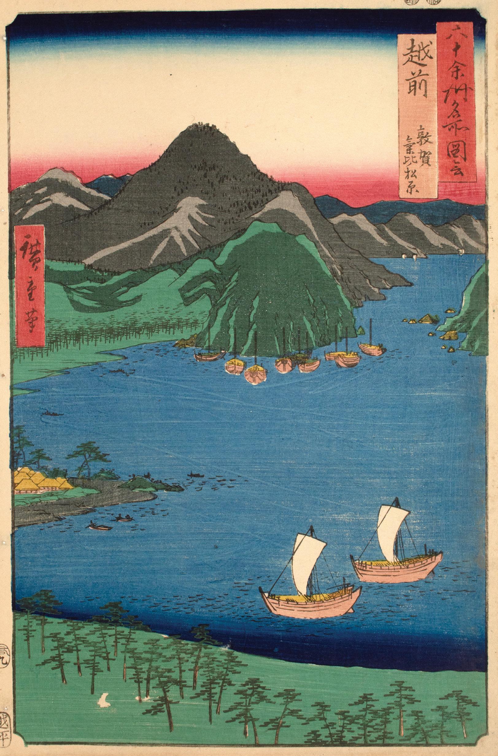
Date: 1853
Medium: Woodblock print
Size: 14.25” x 9.75”
Publisher: Koshimuraya Heisuke
Signature: Hiroshige hitsu
Lined by the lush boughs of Kehi Pine Grove, Tsuruga Bay is quiet beneath the surrounding mountains. Some impressions of this design are overprinted with mica, the hills and mountain peaks shimmering as if they were catching light reflected off the water. While Hiroshige likely consulted many sources during the design of 60-odd Provinces, as many as 26 from the series have been connected to Fuchigami Kyokko’s Exceptional Mountain and Water Landscapes (Sansui kikan, 18001802).11 Today, the former Echizen Province belongs to northern Fukui Prefecture.
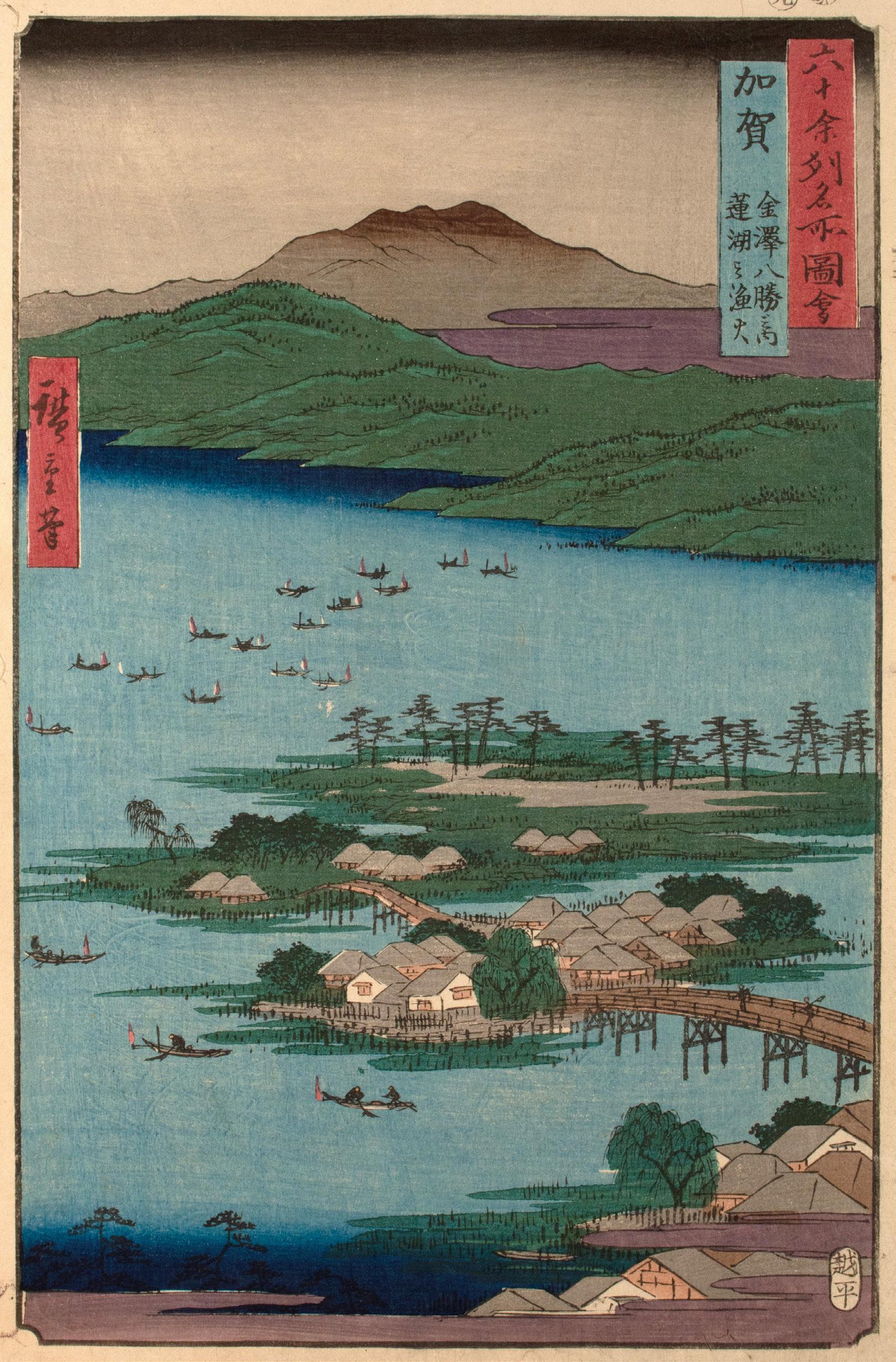
Date: 1855
Medium: Woodblock print
Size: 14.5” x 10.75”
Publisher: Koshimuraya Heisuke
Signature: Hiroshige hitsu
As night shrouds the village, the flames of the fishing boats punctuate the darkness on Lake Renko. Rather than to light the way for the boats, fishermen lit these flames to attract the fish. Like Wakasa Province, Kaga Province was known for its variety of fish. Though Hiroshige nods towards the local specialty (meibutsu) of the area, he does not neglect the natural beauty associated with Kanazawa. Today, the former Kaga Province belongs to southern and western Ishikawa Prefecture.
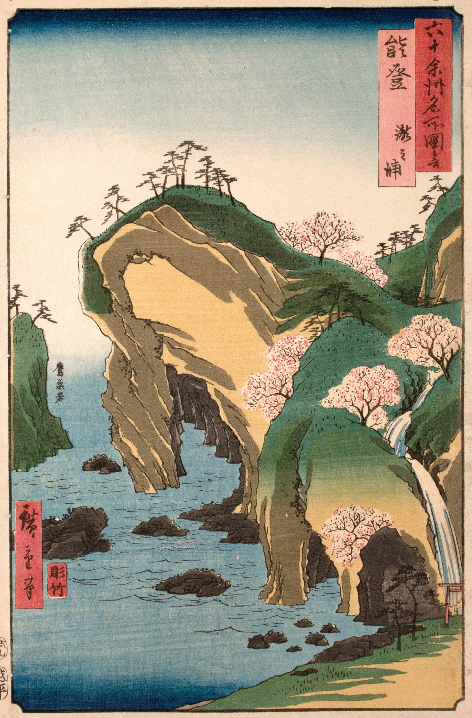
33. Noto Province, Waterfall Bay
Date: 1853
Medium: Woodblock print
Size: 14.25” x 9.75”
Publisher: Koshimuraya Heisuke
Carver: Yokokawa Takejiro
Signature: Hiroshige hitsu
To the far right, a waterfall flows between cherry blossoms in full bloom as the cliffside curls over Ganman Cave. To the left, Hiroshige labels “Falcon Nest Rock,” its twinpined peak half hidden beyond the margin. Ganman Cave was a natural wonder of Noto Province. Hewn by the steady erosion of sea water, the caves were located on the rugged coast of Noto Peninsula. Today you can still visit “Gate Rock,” the namesake of the cave, as well as other sea caves and tide pools around the area. The former Noto Province now belongs to northern Ishikawa Prefecture.
Date: 1853
Medium: Woodblock print
Size: 14.25” x 9.75”
Publisher: Koshimuraya Heisuke
Carver: Yokokawa Takejiro
Signature: Hiroshige hitsu
As evening falls, a floating bridge ( funabashi) extends across the river. Also known as pontoon bridges or boat bridges, floating bridges were not uncommon in Edo-period Japan. Less expensive than a constructed bridge and more convenient than a ferry, floating bridges were composed of a series of planks laid across a line of attached boats. As the river’s current sways the bridge toward the left edge of the design, Hiroshige conveys the movement one could expect at these floating crossings. Today, the former Etchu Province belongs to Toyama Prefecture.

35. Echigo Province, Oyashirazu
Date: 1853
Medium: Woodblock print
Size: 14.25” x 9.75”
Publisher: Koshimuraya Heisuke
Carver: Hori Kosen
Signature: Hiroshige hitsu
As the northern Japanese Alps meet the sea, the cliffs of Oyashirazu were known for their notoriously dangerous conditions. Here, the Hokurikudo Road became a treacherous and narrow strip between the rugged cliffs and the crashing Sea of Japan. The name “Oyashirazu” means “without knowing one’s parents,” alluding to a mother’s poem penned after losing her child to the waves at this site. In Hiroshige’s design, the abbreviated figures on the beach emphasize the enormity of the cliffs and the depth of their many waterside caves. As the sea roils in shades of blue, its waves taller than the figures on the shore, Hiroshige hints at the inherent danger of this famous place. Today, the former Echigo Province corresponds with Niigata Prefecture, excluding Sado Island.

Date: 1853
Medium: Woodblock print
Size: 14.5” x 10.75”
Publisher: Koshimuraya Heisuke
Signature: Hiroshige hitsu
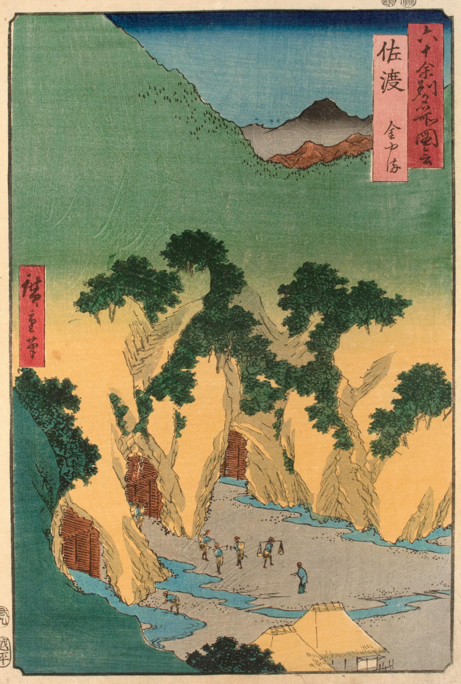
A lush forest gives way to the rocky entrance to the Sado Goldmines in Hiroshige’s depiction of Sado Province. Miners dot the foreground as the mountainside opens to three mining shafts, each internally reinforced with wood. While the island had been known for its gold since the 12th century, the gold from Sado became an important source of wealth for the Tokugawa shogunate during the Edo period. Though the local economy prospered from the mines in the 17th century, by Hiroshige’s time the veins were running dry and the working conditions had significantly declined. The mines finally closed in 1989. Today, the former Sado Province corresponds to Sado Island in Niigata Prefecture.
Date: 1853
Medium: Woodblock print
Size: 14.25” x 9.75”
Publisher: Koshimuraya Heisuke
Signature: Hiroshige hitsu
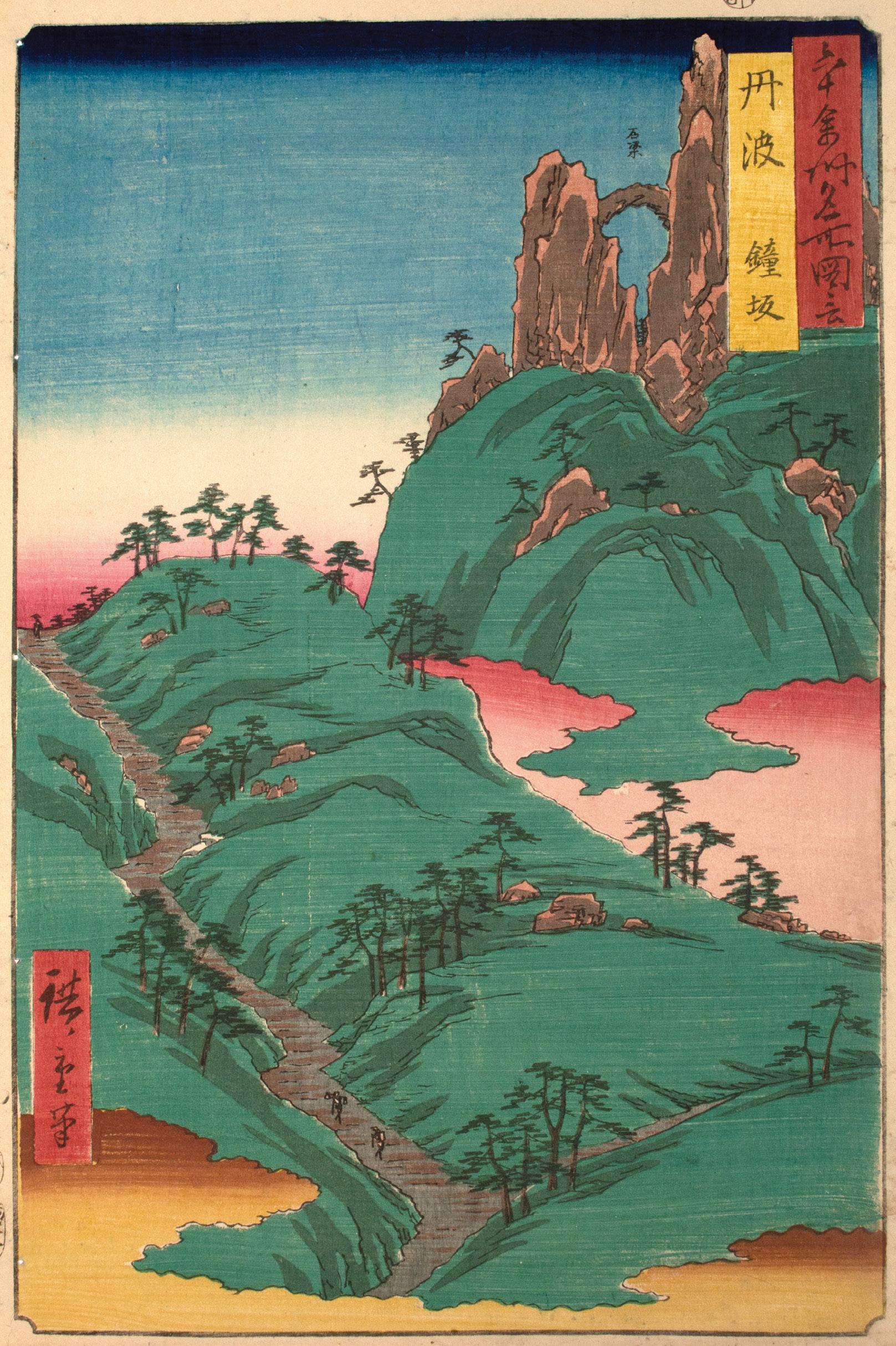
From the bottom of the composition, a narrow path emerges from the clouds, rising sharply through the mountainside before it disappears beyond the horizon line. Located on a connecting road to northern Kyoto, this treacherous ascent was ultimately deemed too steep for travel. The Meiji-period tunnel built in its place still stands today. Off to the top right, Hiroshige identifies the arch between two rock formations as a stone beam, a topographical detail likely informed by travel guides (meishoki) or other artistic iterations of Kanegasaka. Today, the former Tanba Province belongs to central Kyoto Prefecture and east-central Hyogo Prefecture.
38.
Tango Province, Ama-no-Hashidate
Date: 1853
Medium: Woodblock print
Size: 14.5” x 10.75”
Publisher: Koshimuraya Heisuke
Carver: Hori Soji
Signature: Hiroshige hitsu
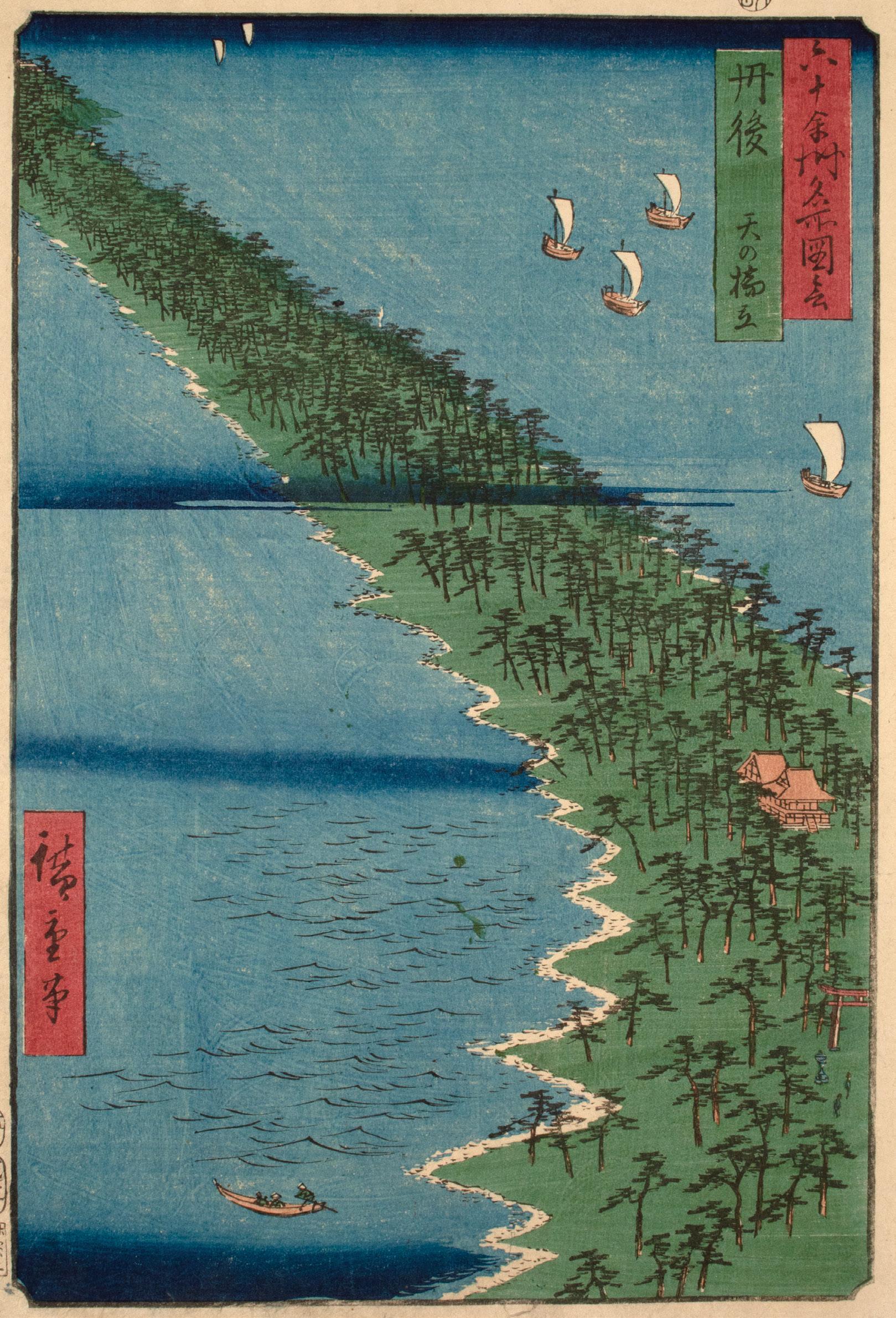
Known as Ama-no-Hashidate (“Heaven’s Bridge”), this narrow strip of pine forest stretches across the water, connecting two sides of Miyazu Bay. Along with Matsushima in Mutsu Province and Itsukushima in Aki Province, Ama-no-Hashidate is one of the “Three Famous Views of Japan (Nihon Sankei).” Rendered in green and blue, Hiroshige adds a dynamism to an otherwise simple scene through a sweeping diagonal–from the Shinto shrine in the bottom right corner to the distant pines in the top left. The French Impressionist artist Edgar Degas is said to have found inspiration for his paintings of dancers in diagonal compositions such as these. Today, the former Tango Province is part of northern Kyoto Prefecture.
39. Tajima Province, Iwai Valley, Kannon Cave
Date: 1853
Medium: Woodblock print

Size: 14.25” x 9.75”
Publisher: Koshimuraya Heisuke
Signature: Hiroshige hitsu
As the river cascades down through Iwai Valley, stairs to Kannon Cave wind up through the opposite cliffs. Part of Washihara Temple on Mount Iwaya, Kannon Cave was home to 16 stone Buddhist sculptures, including six depictions of the Bodhisattva Kannon. While some of Hiroshige’s designs loosely rely on source material, this design provides an example where he closely followed Fuchigami Kyokko’s Exceptional Mountain and Water Landscapes (Sansui kikan, 1800-1802).12 The former Tajima Province is today part of northern Hyogo Prefecture.
40.
Inaba Province, Karo, Koyama
Date: 1853
Medium: Woodblock print
Size:14.25” x 9.75”
Publisher: Koshimuraya Heisuke
Carver: Hori Kosen
Signature: Hiroshige hitsu
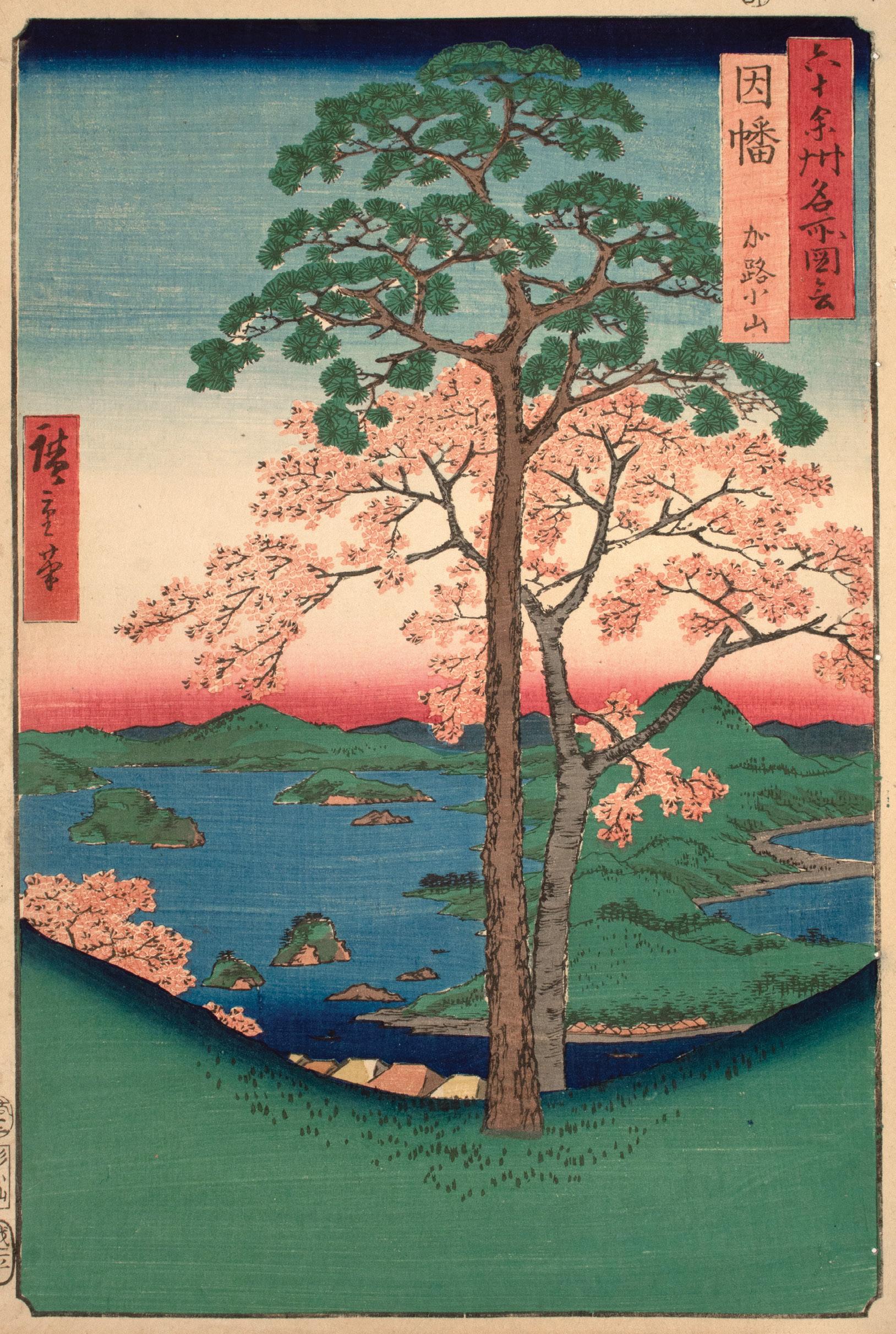
Lake Koyama stretches to the horizon line beneath blushing cherry blossoms and a sturdy pine. The village of Karo sits on the opposite bank, reduced to small triangles at the foot of the mountain. Once a bay, over time a sandbar formed, separating Lake Koyama from the Sea of Japan. This historical connection to the sea explains the diversity of fish that populate these waters. Today, Inaba Province belongs to eastern Tottori Prefecture.
41. Hoki Province, Ono, Distant View of Mount Daisen
Date: 1853
Medium: Woodblock print
Size: 14.5” x 10.75”
Publisher: Koshimuraya Heisuke
Carver: Yokokawa Takejiro
Signature: Hiroshige hitsu
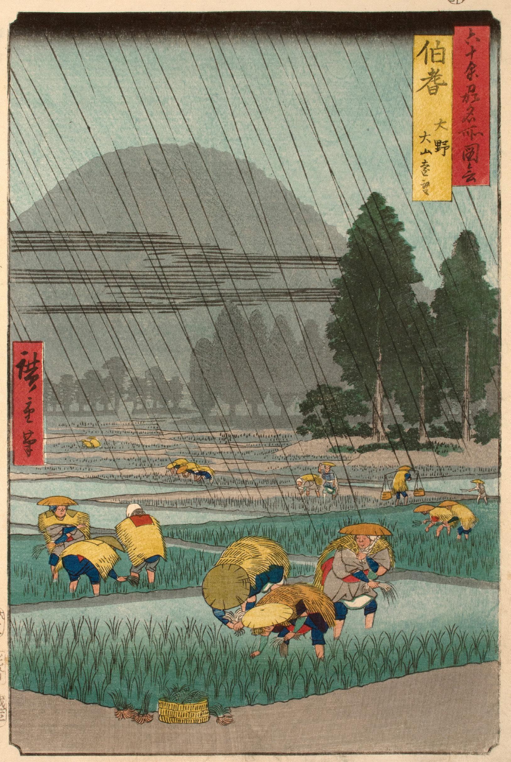
Beneath a dark sky the wind drives the rain on a diagonal. Shrouded in fog and rain, Mount Daisen is reduced to a silhouette, a backdrop for the figures hard at work planting the rice paddies. Beneath their straw cloaks and wide brimmed hats, they appear undaunted by the downpour. It is clear that their work is far from over as bundled plants overflow from the basket in the foreground. Between the weather and sympathetic figures, Hiroshige’s view of Hoki Province creates a tangible sense of time and place. Today, Hoki Province belongs to western Tottori Prefecture.
Date: 1853
Medium: Woodblock print
Size: 14.5” x 10.75”
Publisher: Koshimuraya Heisuke
Carver: Sugawa Sennosuke
Signature: Hiroshige hitsu
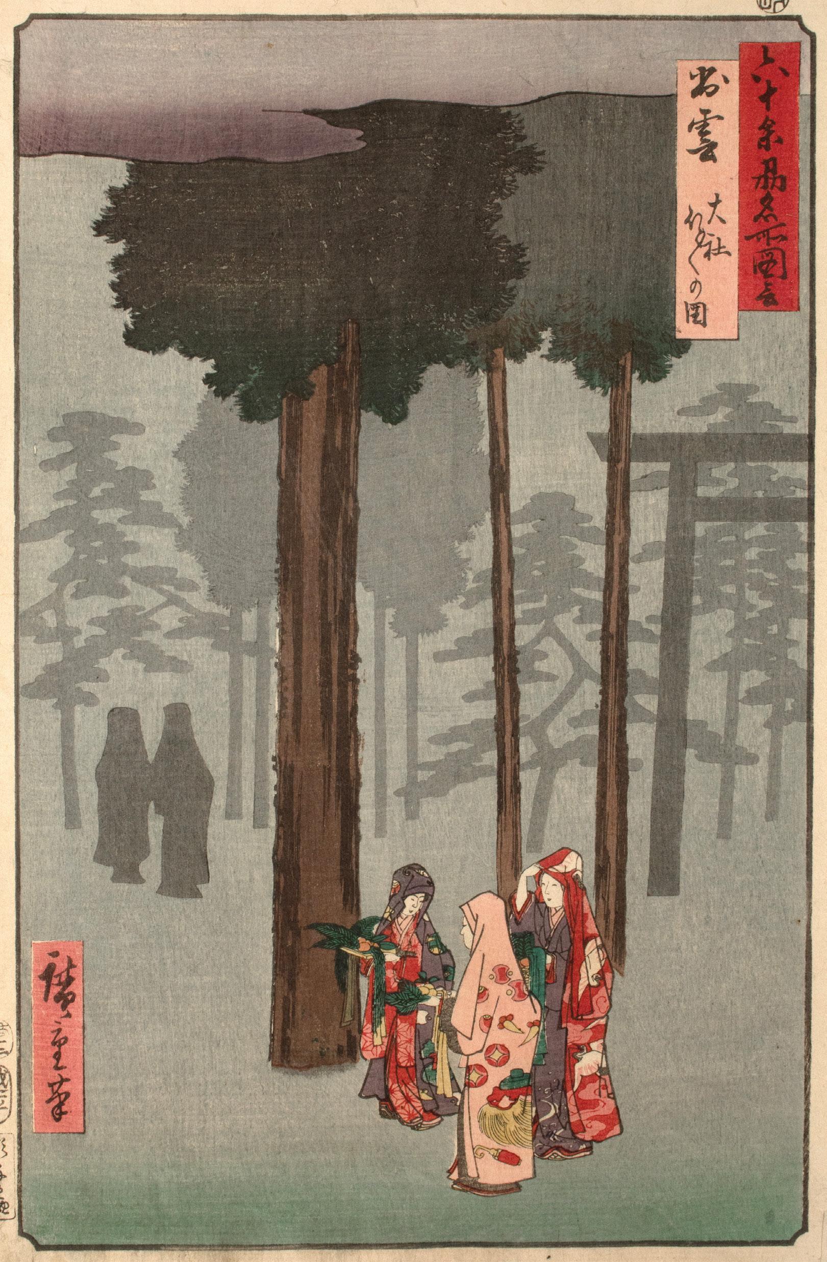
Beneath a canopy of cedar, three women pass through the grounds of Izumo Grand Shrine, one of the most important Shinto sites in Japan. As the fog reduces most of the scene to silhouette, the women carry trays bedecked with auspicious symbols of the New Year. Hotohoto is a New Year’s celebration local to the region. The festival takes its name from the onomatopoeia of knocking on a door. There are different traditions associated with this festival, including leaving rice cakes (mochi) on the doorstep for a god’s messenger to replace with a straw craft, or children going door-to-door to receive mochi and small gifts. Today, the former Izumo Province belongs to modern Shimane Prefecture.
43. Iwami Province, Mount Takatsu, Salt Beach
Date: 1853
Medium: Woodblock print
Size: 14.5” x 10.75”
Publisher: Koshimuraya Heisuke
Carver: Hori Soji
Signature: Hiroshige hitsu
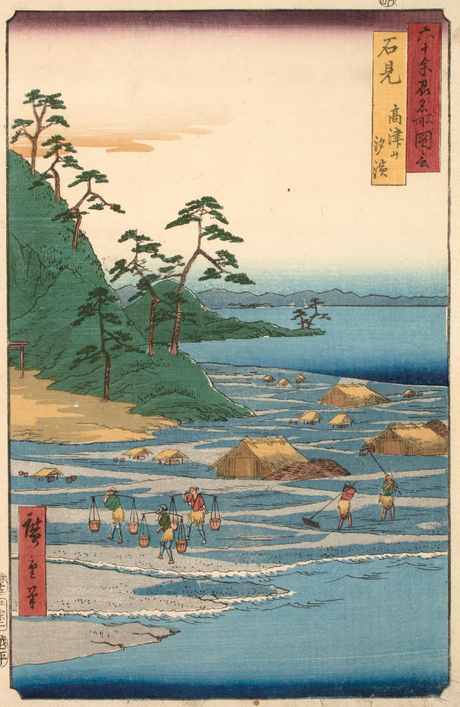
At the base of Mount Takatsu, Hiroshige focuses on a valuable local product. As in many parts of the world at this time, salt was nearly as valuable as gold. Japan derived its salt from the sea. In a technique dating to the 8th century known as agehama, water was carried from the sea and spread onto banked sand and clay pots to evaporate. The resulting brine would be boiled down to form salt.13 This laborious process can still be found today at the artisanal salt farms along Noto Peninsula in Ishikawa Prefecture. Today, the former Iwami Province belongs to western Shimane Prefecture.
13. Laura Cocora and Kaori Brand, “Preserving Japan’s Sea Salt Making Tradition,” Our World (United Nations University, June 9, 2010), https://ourworld.unu.edu/en/ preserving-japans-sea-salt-makingtradition.
44. Oki Province, Takuhi Shrine
Date: 1853
Medium: Woodblock print
Size: 14.5” x 10.75”
Publisher: Koshimuraya Heisuke
Carver: Hori Kosen
Signature: Hiroshige hitsu
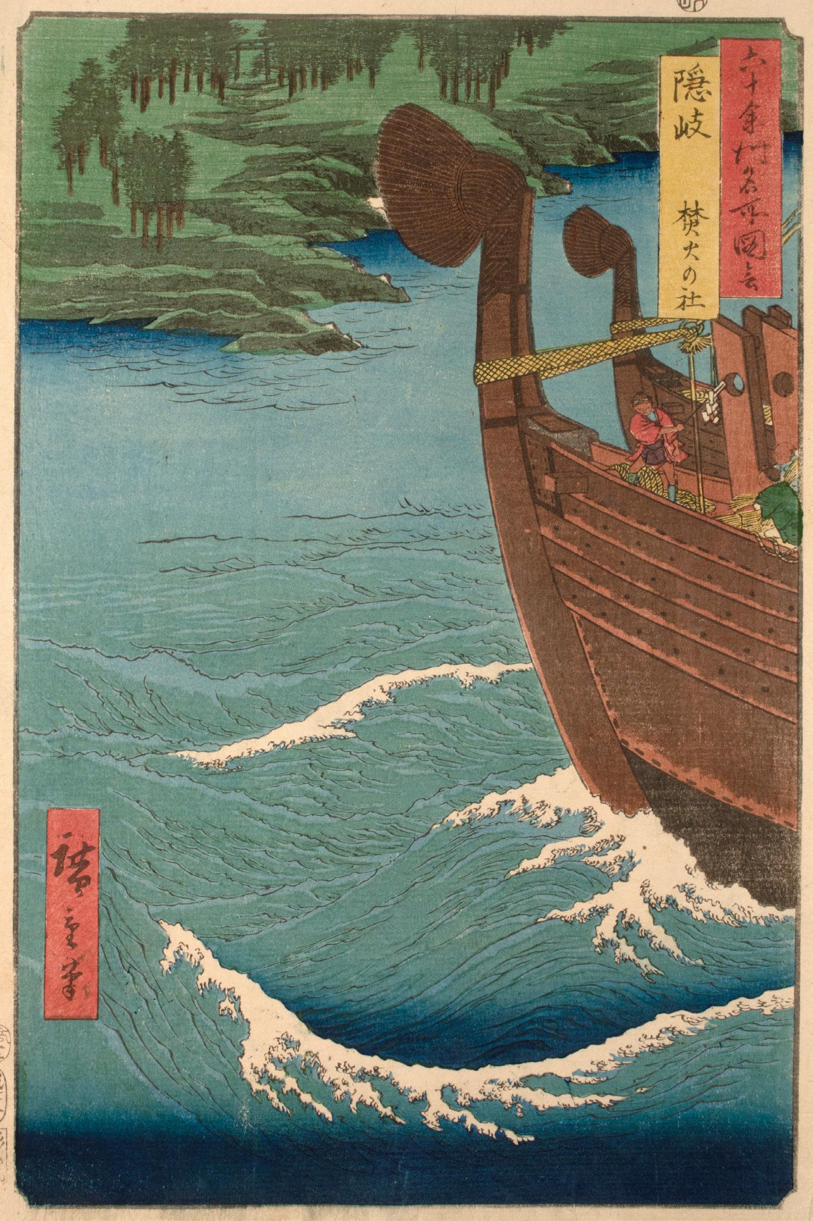
Cutting through white-capped waves, the bows of two kitamaebune (North Bound Ships) approach from the right margin. This term refers to both the vessels and the important shipping route that wound from Osaka through the Sea of Japan to Hokkaido from the mid-Edo period well into the Meiji period. These merchant ships would sail from port to port, buying and selling throughout their journey. Through their commercial activities, these ships spread regional culture–from music to fashion. In the early 20th century, railroads replaced these shipping routes. The former Oki Province now composes Oki District of Shimane Prefecture, located on the Oki Islands in the Sea of Japan.14
14. Japan Heritage, “What is Kitamaebune?” Japan Heritage of the Agency for Cultural Affairs. https://en.kitamae-bune.com/about/ main/
45.
Harima Province, Maiko Beach
Date: 1853
Medium: Woodblock print
Size: 14.5” x 10.75”
Publisher: Koshimuraya Heisuke
Signature: Hiroshige hitsu
Beneath the shade of towering pines, Maiko Beach recedes into the blue horizon. In this design, Hiroshige incorporates elements of one-point perspective. Following the diagonal of the coast, the pines grow smaller towards a vanishing point to the right edge of the horizon line. He heightens this sense of distance through the truncated pine to the far left. As the trunk grows beyond the left margin, a single bough cuts back into the frame. Between the closeness of the first pine and the use of onepoint perspective, Hiroshige creates a tangible sense of depth. Today, the former Harima Province belongs to southwestern Hyogo Prefecture.
Date: 1853
Medium: Woodblock print
Size: 14.5” x 10.75”
Publisher: Koshimuraya Heisuke
Signature: Hiroshige hitsu
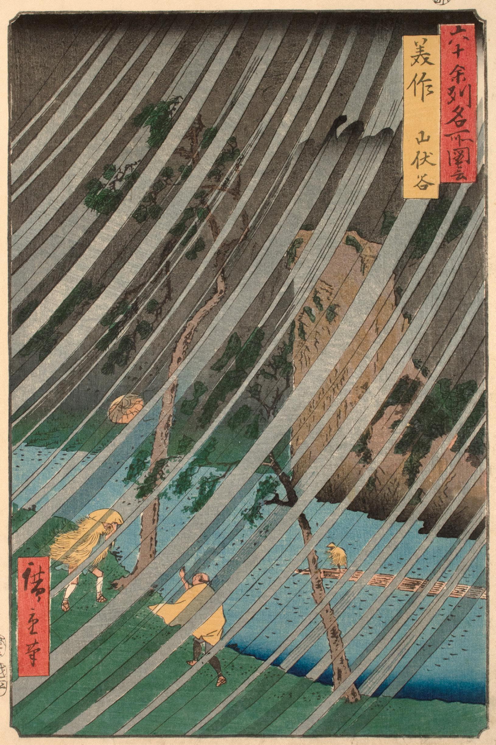
The wind drives torrents of rain in bold, grey sheets as travelers brace themselves against the storm in Yamabushi Valley. On the riverbank one figure holds onto his hat, but it’s too late for the other. He watches, arm outstretched as the wind carries it away. On the rippling surface of the Yoshii River, a third figure hunches over against the wind. As Hiroshige’s sweeping lines evoke the movement and intensity of the storm, the sparkle of mica in the dark sky and shadows adds to the stormy atmosphere. Today, the former Mimasaka Province belongs to northeastern Okayama Prefecture.
Date: 1853
Medium: Woodblock print
Size: 14.5” x 10.75”
Publisher: Koshimuraya Heisuke
Signature: Hiroshige hitsu
Dominating the composition at a three-quarter view, Yugasan torii rises from Tanokuchi Harbor, towering over the village, ships, and Inland Sea beyond. Hiroshige lends the scene a sense of depth through the use of foreshortening. Torii mark the entrance to sacred Shinto sites, in this case Yuga Shrine on Mount Yuga. Also home to Rendai Temple, Mount Yuga was a popular pilgrimage destination. Today, the former Bizen Province belongs to southeastern Okayama Prefecture.
Date: 1853
Medium: Woodblock print
Size: 14.5” x 9.75”
Publisher: Koshimuraya Heisuke
Signature: Hiroshige hitsu
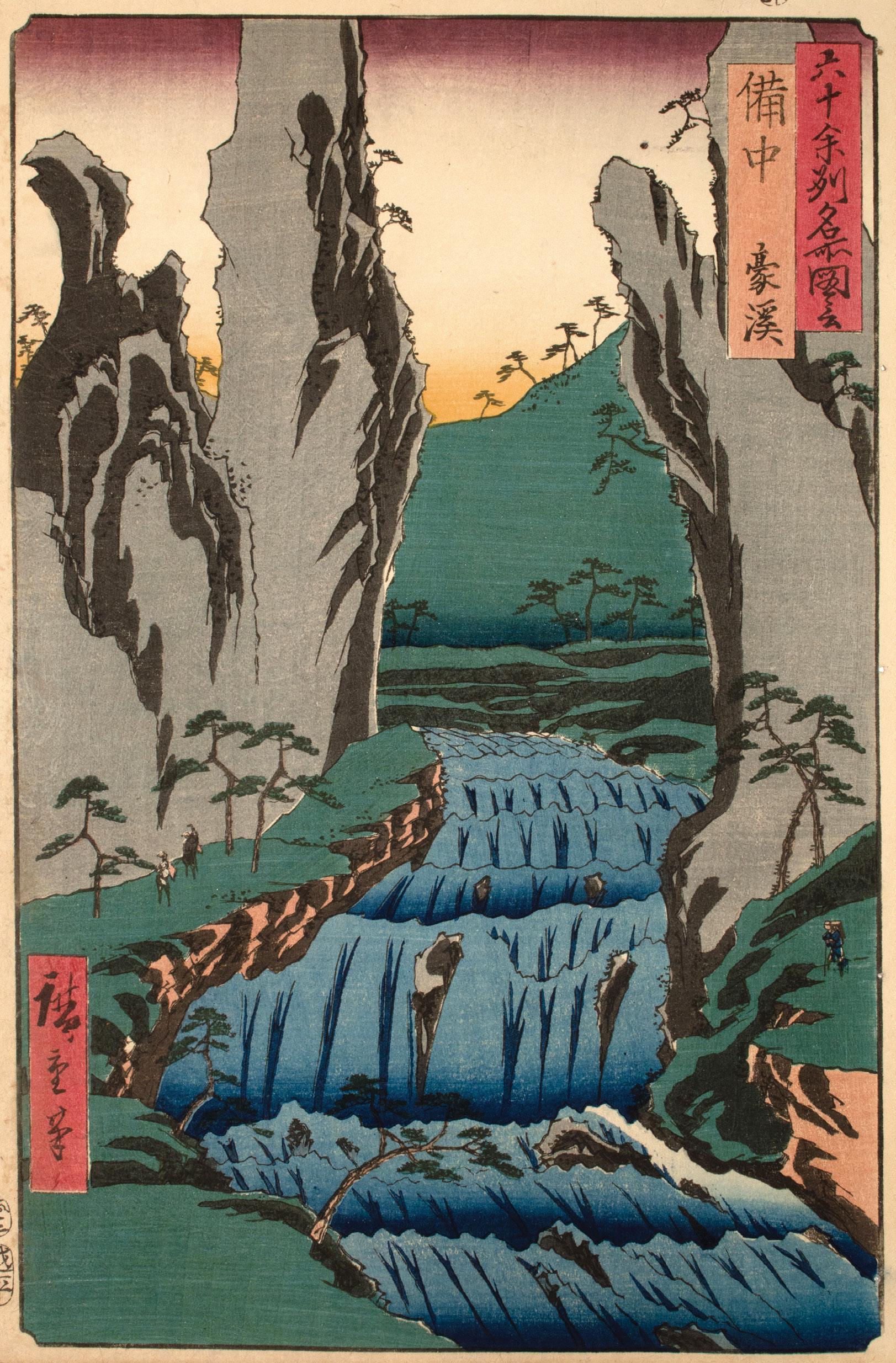
As the Makidani River cascades through Gokei Valley, the distinctive rock formations native to this region rise from the bank. The rugged edge of the riverbed and pale crests of the rapids speak to the strength of the current. Gokei Valley was best known for its autumnal beauty. Here Hiroshige forgoes the fiery shades of fall and emphasizes the monumentality of the landscape through the scale of the travelers and trees. The former Bitchu Province now belongs to western Okayama Prefecture. Today, Gokei Valley continues to attract those seeking the seasonal beauty of autumn.
49.
Bingo Province, Abuto, Kannon Temple
Date: 1853
Medium: Woodblock print
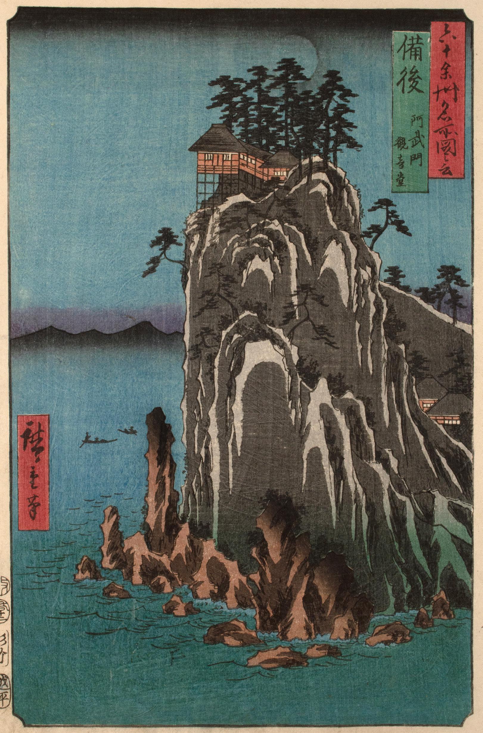
Size: 14.5” x 10.75”
Publisher: Koshimuraya Heisuke
Carver: Yokokawa Takejiro
Signature: Hiroshige hitsu
Perched atop Abuto Cape, a small temple overlooks the Inland Sea. A Zen Buddhist site, Kannon Temple is home to an eleven-faced stone sculpture of the Bodhisattva Kannon known as Abuto Kannon. Associated with conception and childbirth, this temple continues to attract expectant mothers wishing for a safe delivery. From the purple and black on the horizon, to the pale light reflected from the sea onto cliff base, the use of bokashi (gradation) lends a serene atmosphere to the night. Even the full moon subtly breaks through the darkness with the delicate use of black shading. While Hiroshige likely suggested colors for the final print, it was the printer who executed this masterful bokashi Today, Bingo Province belongs to eastern Hiroshima Prefecture.
50.
Aki Province, Itsukushima, Depiction of a Festival
Date: 1853
Medium: Woodblock print
Size: 14.5” x 10.75”
Publisher: Koshimuraya Heisuke
Signature: Hiroshige hitsu
Against the backdrop of the Onoseto Strait and approaching ships, the iconic torii of Itsukushima Shrine rises from the sea, truncated by the left and top margins. To the right, a boat decorated for the Kangensai Festival steers toward the torii and the shrine beyond. Held on the 17th day of the 6th month of the lunar calendar, the Kangensai Festival takes its name from kangen, a type of classical court music played with winds, strings, and percussion. During this music-filled celebration, an elaborate boat of musicians ferries a portable shrine across the strait, returning just before midnight. Itsukushima, also known as Miyajima, is one of the “Three Famous Views of Japan” (Nihon Sankei). Today, Aki Province belongs to western Hiroshima Prefecture.
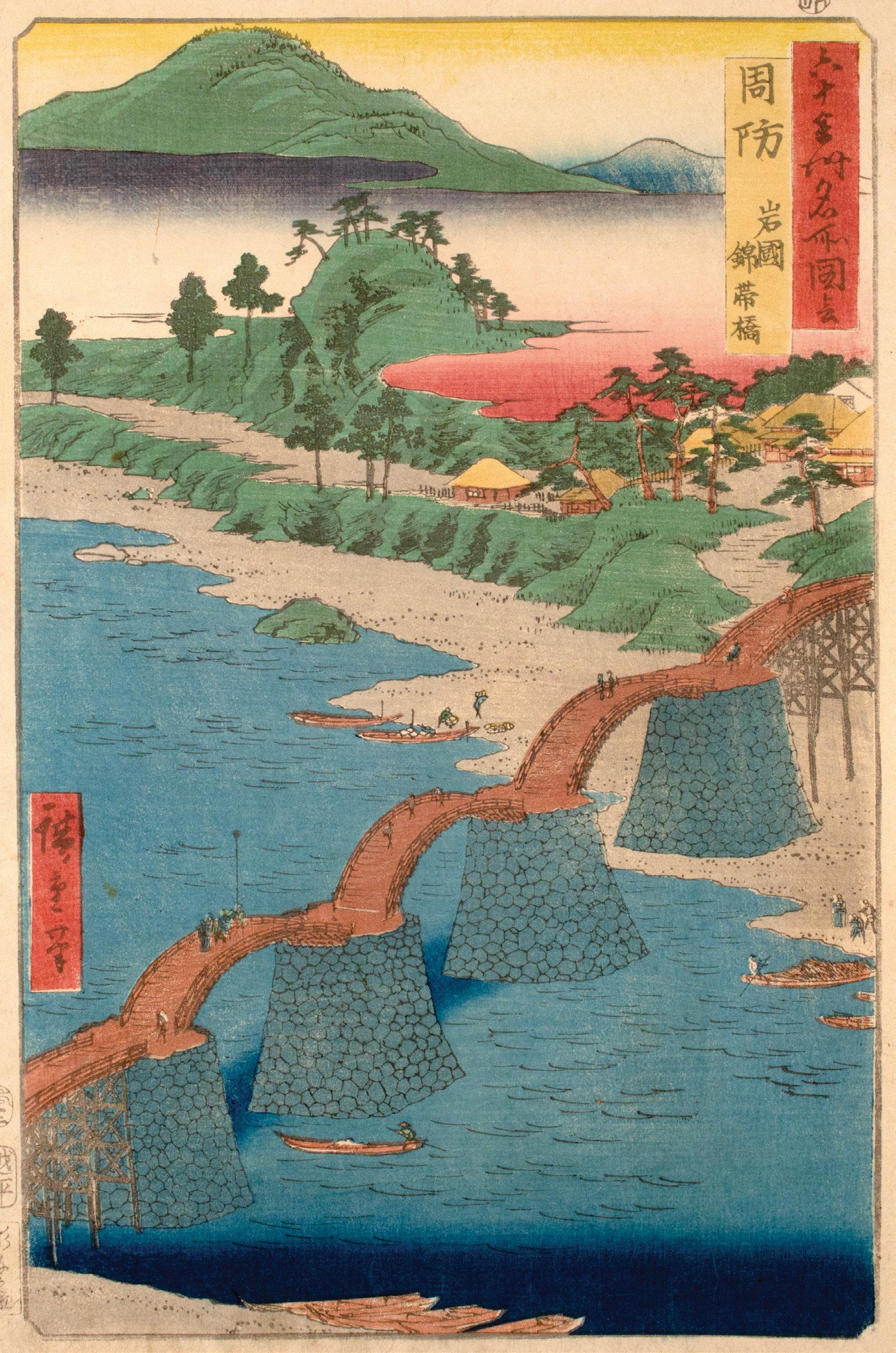
Date: 1853
Medium: Woodblock print
Size: 14.5” x 10.75”
Publisher: Koshimuraya Heisuke
Carver: Sugawa Sennosuke
Signature: Hiroshige hitsu
Known as one of Japan’s Three Remarkable Bridges, Kintai Bridge crosses the Nishiki River in five arches supported by four stone pillars. Following the destruction of several wooden bridges by fire and flood, Kintai Bridge was built with stone supports in 1673. The castle town of Iwakuni instituted a special tax to maintain the bridge, restoring its components regularly. Though the bridge has faced several periods of disrepair over the years, it was fully restored in 2001 and can be visited today. The former Suo Province corresponds to eastern Yamaguchi Prefecture.
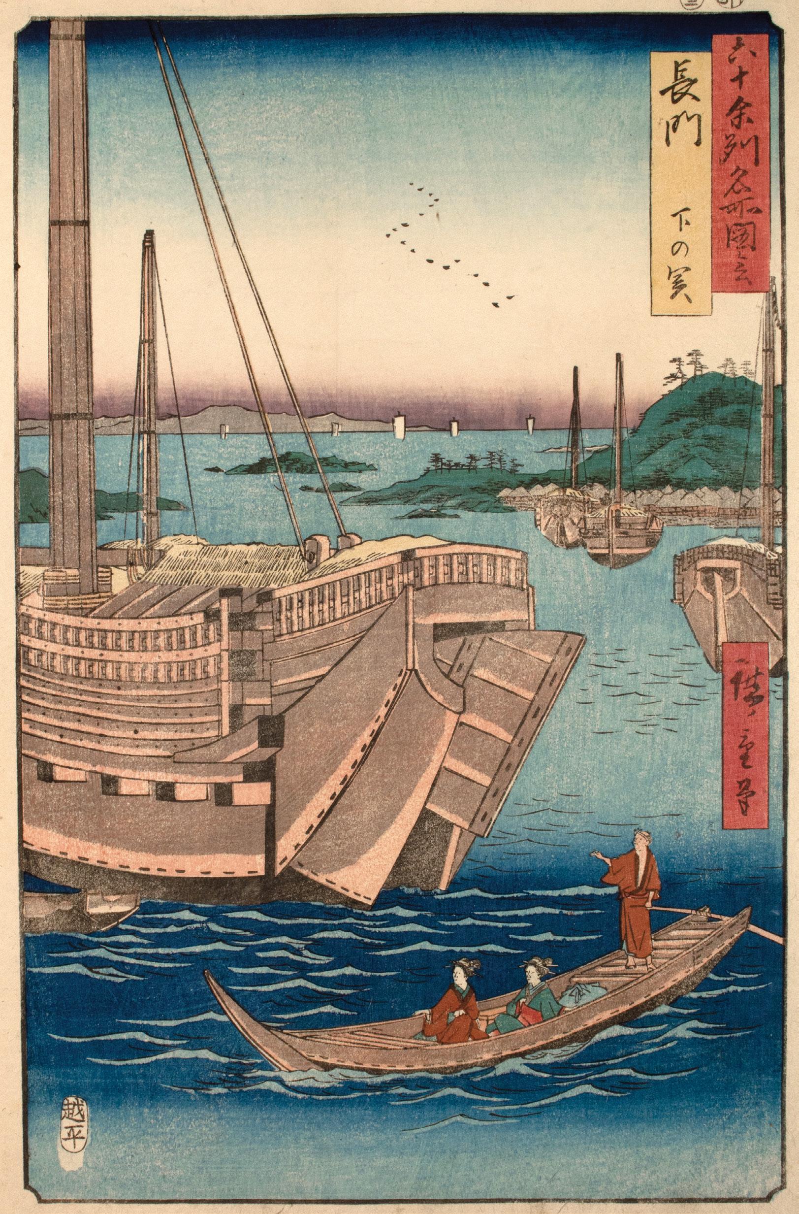
Date: 1856
Medium: Woodblock print
Size: 14.5” x 10.75”
Publisher: Koshimuraya Heisuke
Signature: Hiroshige hitsu
Located at the western tip of Honshu, Shimonoseki sits just across the Kanmon Straits from Kyushu. This area was home to Dan-noura, the historical setting of the decisive 1185 battle between the Minamoto and Taira clans during the Genpei War. With this strategic position, the port had functioned as a bustling center for trade and a site of both international conflict and reconciliation since ancient times. In this design, Hiroshige brings Nagato Province’s commercial importance to the forefront. As towering merchant ships crowd the harbor, the narrow passenger boat in the foreground lends a sense of scale. Today, the former Nagato Province is part of Yamaguchi Prefecture.
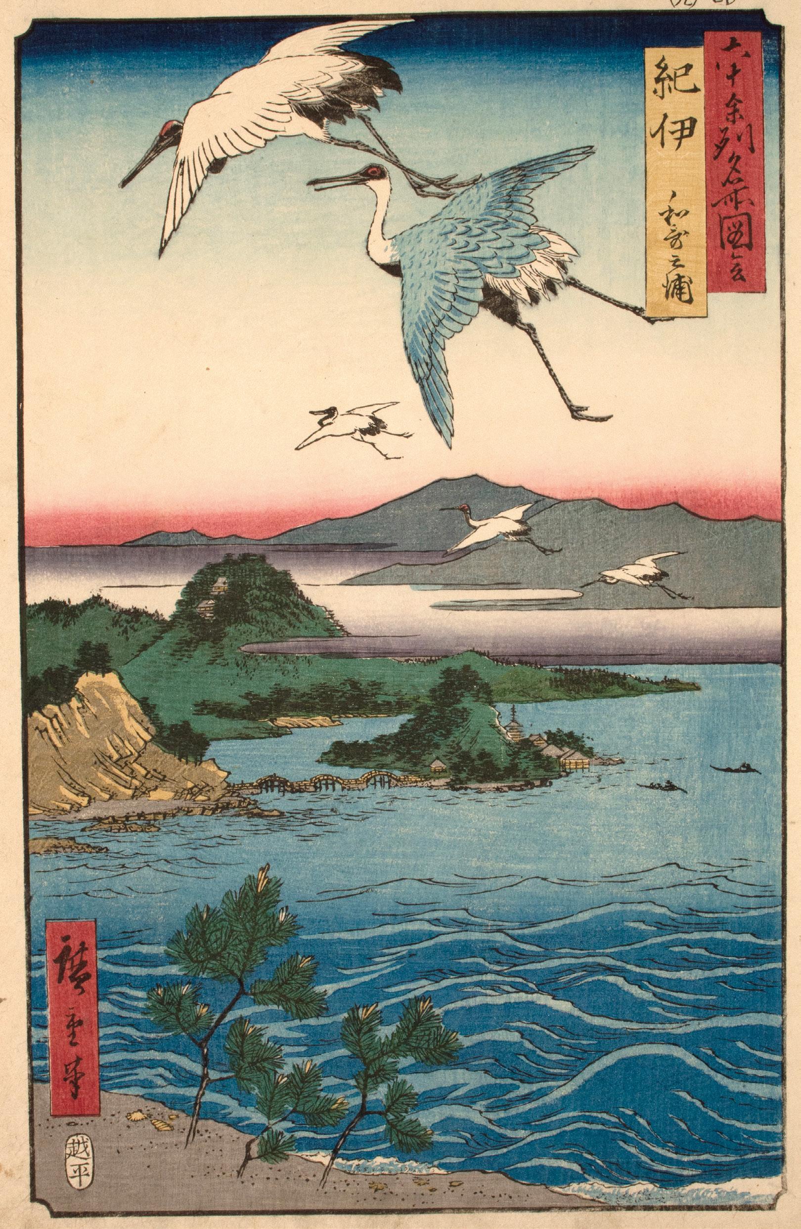
53. Kii Province, Waka-no-ura
Date: 1855
Medium: Woodblock print
Size: 14.5” x 10.75”
Publisher: Koshimuraya Heisuke
Signature: Hiroshige hitsu
As the tidal flats appear and disappear, the natural beauty of Waka-no-ura has inspired many poets over the ages. Hiroshige presents this storied landscape through a crane’s eye view. While the bridges, houses, and mountains appear small in the distance, the cranes fly close enough to the viewer for them to appreciate the texture of the snowy feathers, made tangible through karazuri (blind printing). In this technique, a line block would be printed without ink atop a designated area, embossing a pattern into the paper. Today, Kii Province corresponds to southern Mie Prefecture and Wakayama Prefecture.
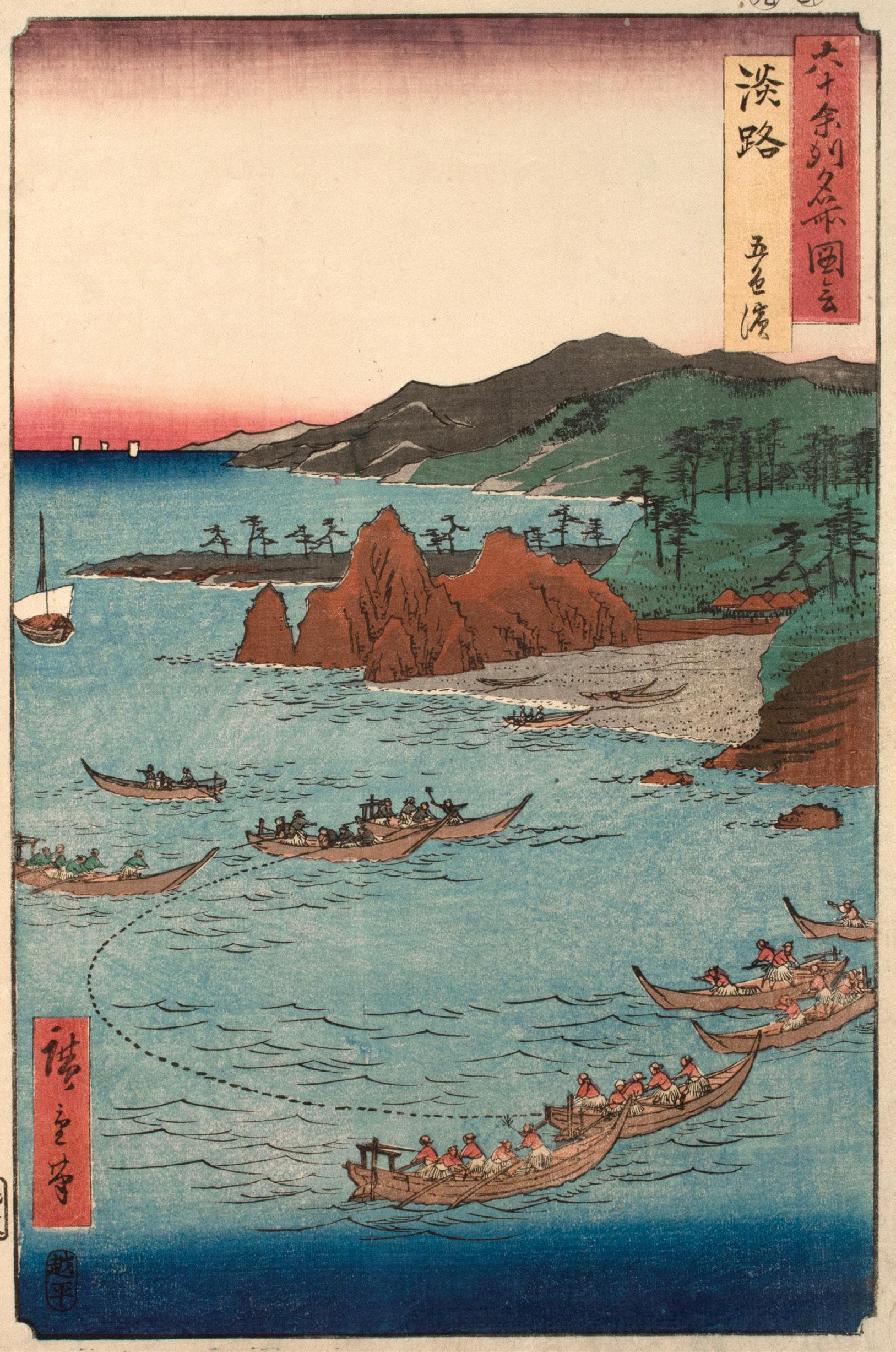
Date: 1855
Medium: Woodblock print
Size: 14.5” x 10.75”
Publisher: Koshimuraya Heisuke
Carver: Hori Tomo
Signature: Hiroshige hitsu
The name Goshiki means “five colors” and refers to the different shades of pebbles found on this beach. Located in the Inland Sea between Honshu and Shikoku, Awaji Island was famous for its sea bream. In this design, Hiroshige alludes to this local delicacy through a fishing scene. Teams of fishermen work together to manage the large net that floats between them. One can imagine the bounty of fish they will catch that day. The former Awaji Province is part of modern Hyogo Prefecture.
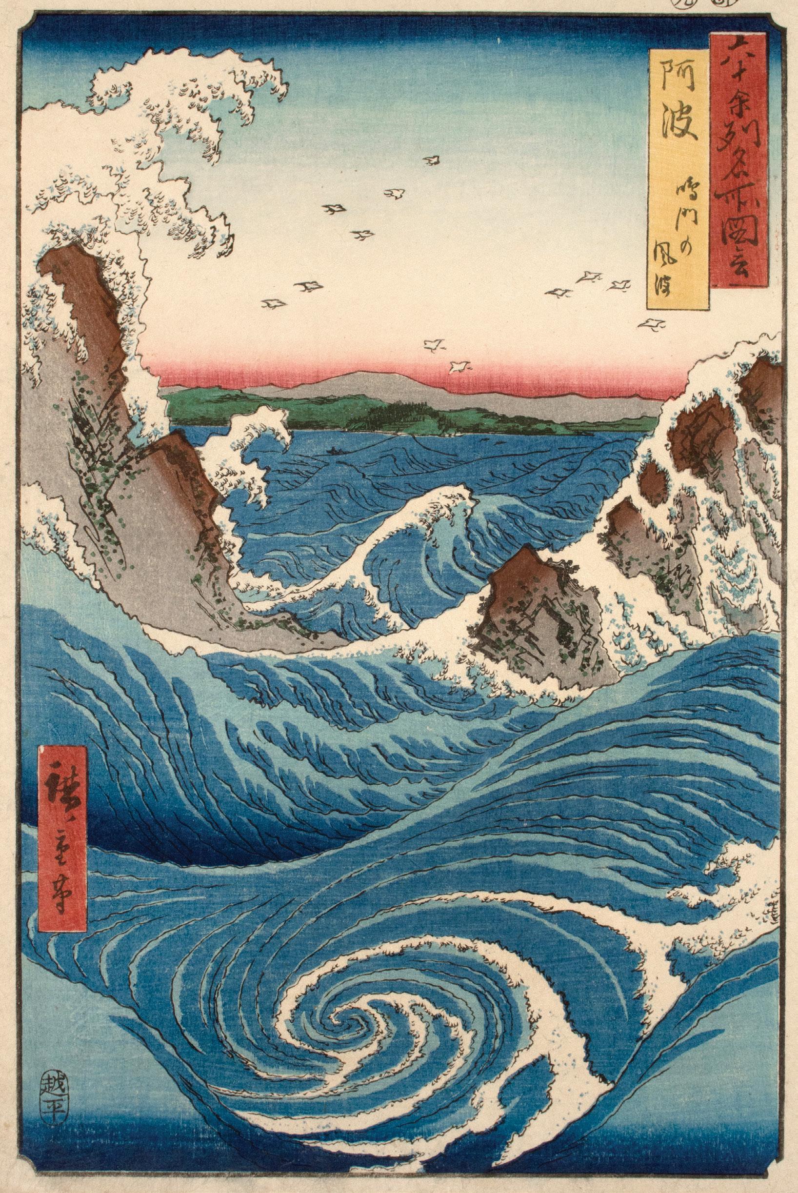
55. Awa Province, Naruto Whirlpools
Date: 1855
Medium: Woodblock print
Size: 14.5” x 10.75”
Publisher: Koshimuraya Heisuke
Signature: Hiroshige hitsu
White surf crashes against the rocks overhead and the sea churns at the Naruto whirlpools. As the tides change, the water passing through Naruto Strait, a channel connecting the Inland Sea and the Pacific Ocean, creates whirlpools that can reach a diameter of 20 meters. In Hiroshige’s design, the viewer is nearly submerged in one such vortex as the sea roils in shades of blue. In the distance, the current quiets and plovers fly overhead. Today, the whirlpools remain a natural attraction, typically appearing twice a day with the changing tides. The former Awa Province now belongs to modern Tokushima Prefecture.
Date: 1855
Medium: Woodblock print
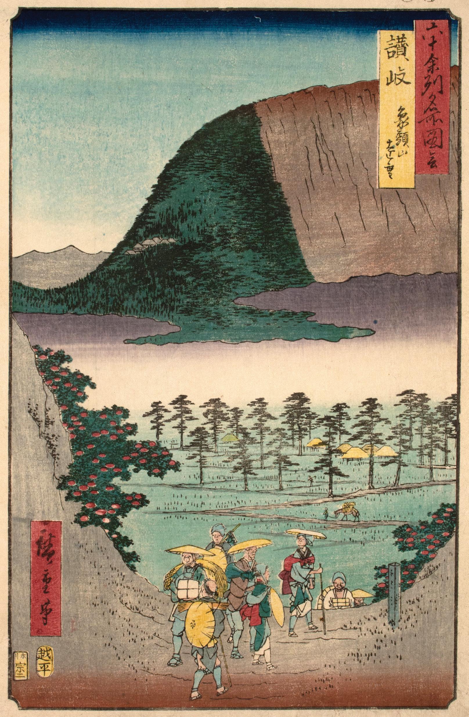
Size: 14.5” x 10.75”
Publisher: Koshimuraya Heisuke
Carver: Hori Soji
Signature: Hiroshige hitsu
Between the red-flowering bushes, a group of travelers crest the hill in the foreground and Mount Zozu rises from the clouds. Meaning “elephant head,” Mount Zozu took its name from its shape: the curve the mountain marked the forehead, sloping down to the trunk. The grey roofs of Kotohiragu Shrine peek out from the trees on the mountainside and form the closed eye of a sleeping elephant. Dedicated to the guardian deities of fishermen and sailors, Kotohiragu, affectionally known as “Konpira-san,” was a popular pilgrimage site during the Edo period. Hiroshige alludes to this popularity with the crowded path in the foreground. Today, the former Sanuki Province corresponds with Kagawa Prefecture.
Date: 1855
Medium: Woodblock print
Size: 14.5” x 10.75”
Publisher: Koshimuraya Heisuke
Carver: Hori Soji
Signature: Hiroshige hitsu
From the tip of the truncated sail in the foreground, the eye follows the diagonal path of the geese overhead. Beyond the waterside village of Saijo, white castle walls can be seen among the pines, small beneath the mountain range. Measuring 1982 meters high, Mount Ishizuchi is the highest peak on Shikoku. Though today it is known for its steep rock formations that come to a point, Hiroshige presents a flat-topped peak. This characterization of the mountain is consistent with his much consulted source, Exceptional Mountain and Water Landscapes (Sansui kikan, 1800-1802), illustrated by Fuchigami Kyokko (1753-1816).15 Today, the former Iyo Province belongs to modern Ehime Prefecture.
Date: 1855
Medium: Woodblock print
Size: 14.5” x 10.75”
Publisher: Koshimuraya Heisuke
Signature: Hiroshige hitsu
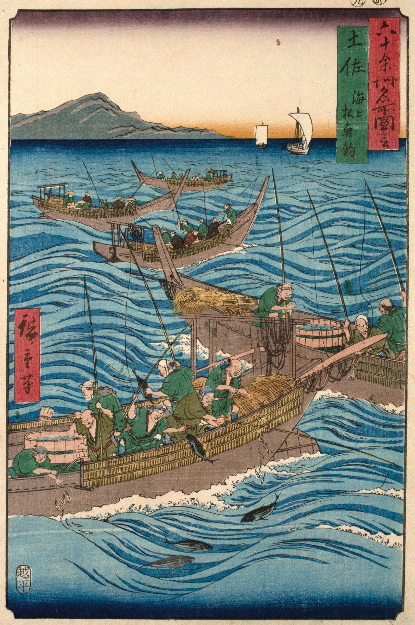
Unbothered by the rough water, fishermen of Tosa Province cast their lines. In the foreground, the process can be seen up close. To the far left and right, men throw smaller fish from the buckets on board to lure the bonito. Two of the fishermen hoist their catch into the boat while three fish gather near the hull. Bonito was a local specialty (meibutsu) and important export for Tosa Province. The fishermen here chose to use poles rather than nets to minimize the stress and damage to the fish. It was thought that this gentle approach would optimize the fishes’ flavor.16 The former Tosa Province spanned southern Shikoku, corresponding with modern Kochi Prefecture.
16. Minneapolis Institute of Art, online catalog entry for Utagawa Hiroshige’s “Bonito Fishing on the Ocean,” collection database catalog, accessed January 31, 2023. https://collections. artsmia.org/art/61327/bonitofishing-on-the-ocean-utagawahiroshige
59. Chikuzen Province, Hakozaki, Umi-no-Nakamichi
Date: 1855
Medium: Woodblock print
Size: 14.5” x 9.75”
Publisher: Koshimuraya Heisuke
Carver: Hori Soji
Signature: Hiroshige hitsu
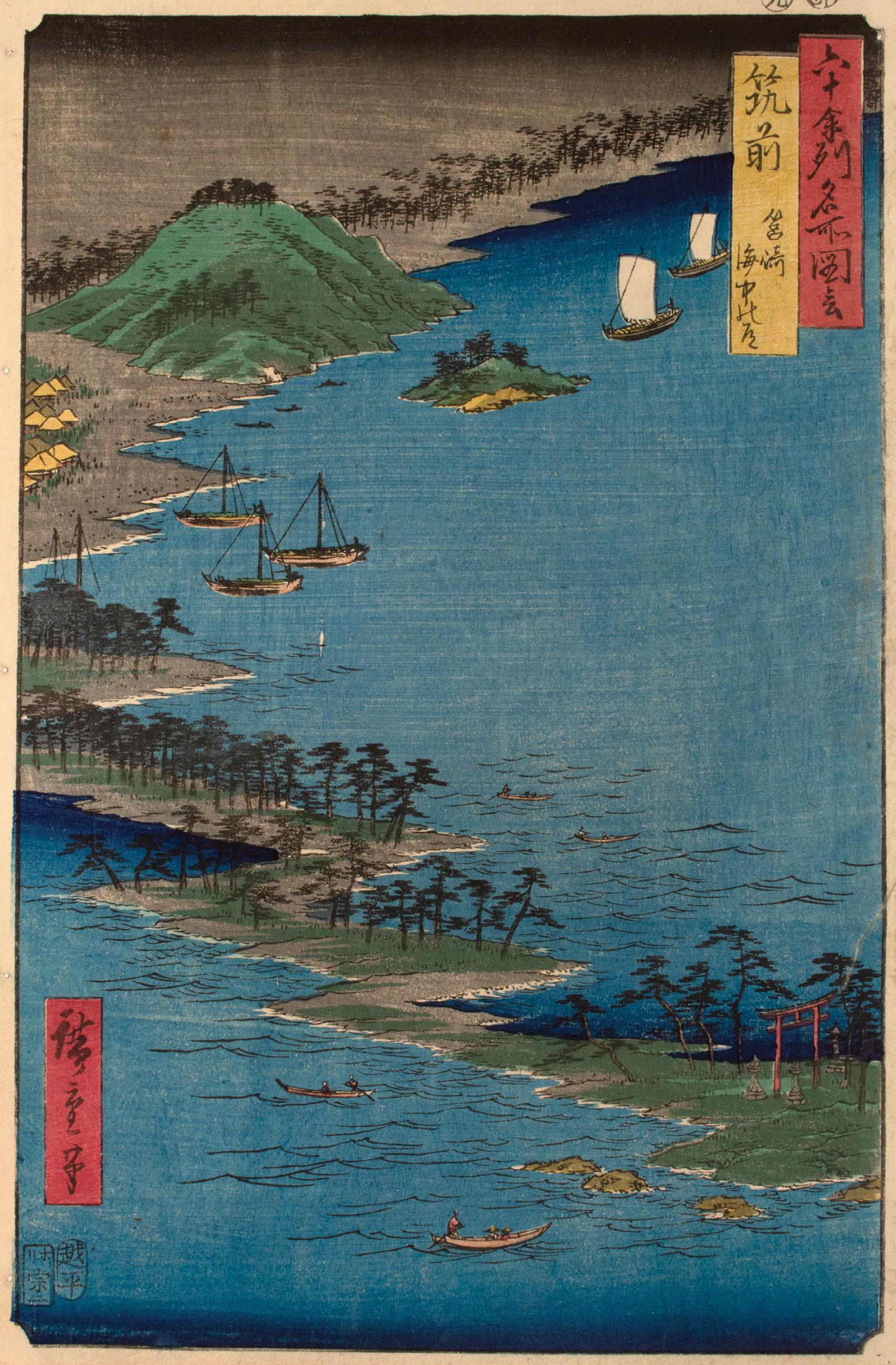
From the torii of Hakozaki Shrine in the bottom right, the pine-covered sandbar winds towards the village and the coast beyond. To the left, small boats float on the Genkai Sea, while large ships sail into Hakata Bay to the right. Known as Umi-no-nakamichi, or “Path in the Middle of the Sea,” this strip of land connects Kyushu to Shika-no-shima. Today, the land has been turned into an extensive seaside leisure park. The former Chikuzen Province now belongs to western Fukuoka Prefecture.
Weir
Date: 1855
Medium: Woodblock print
Size: 14.5” x 9.75”
Publisher: Koshimuraya Heisuke
Signature: Hiroshige hitsu
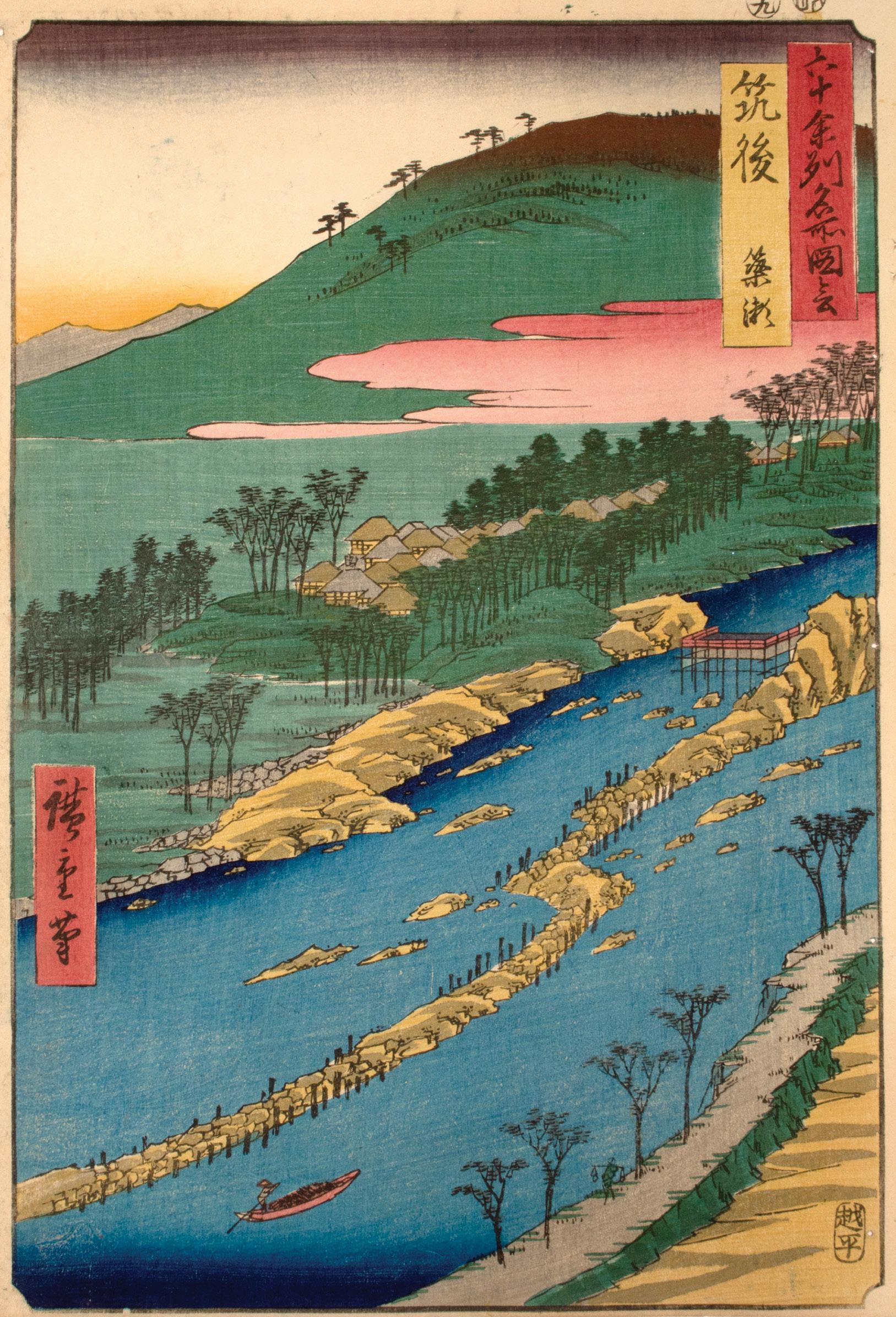
Ayu, small river trout sometimes known as sweetfish, were considered a specialty of Chikugo Province during the summer months. In this design, the Chikugo River flows through the foreground, separating Chikugo Province on the left from Chikuzen Province to the bottom right. The village of Haki appears within the trees of the far bank, as the mountains rise above the pink clouds of sunset. To the top left of the river, the weir (dam) catches the ayu as they swim with the current. Made of bamboo and wood, this type of fish trap allows water and smaller fish to pass through, while larger fish are captured and gathered by the fisherman. Today, the former Chikugo Province corresponds to southwestern Fukuoka Prefecture.
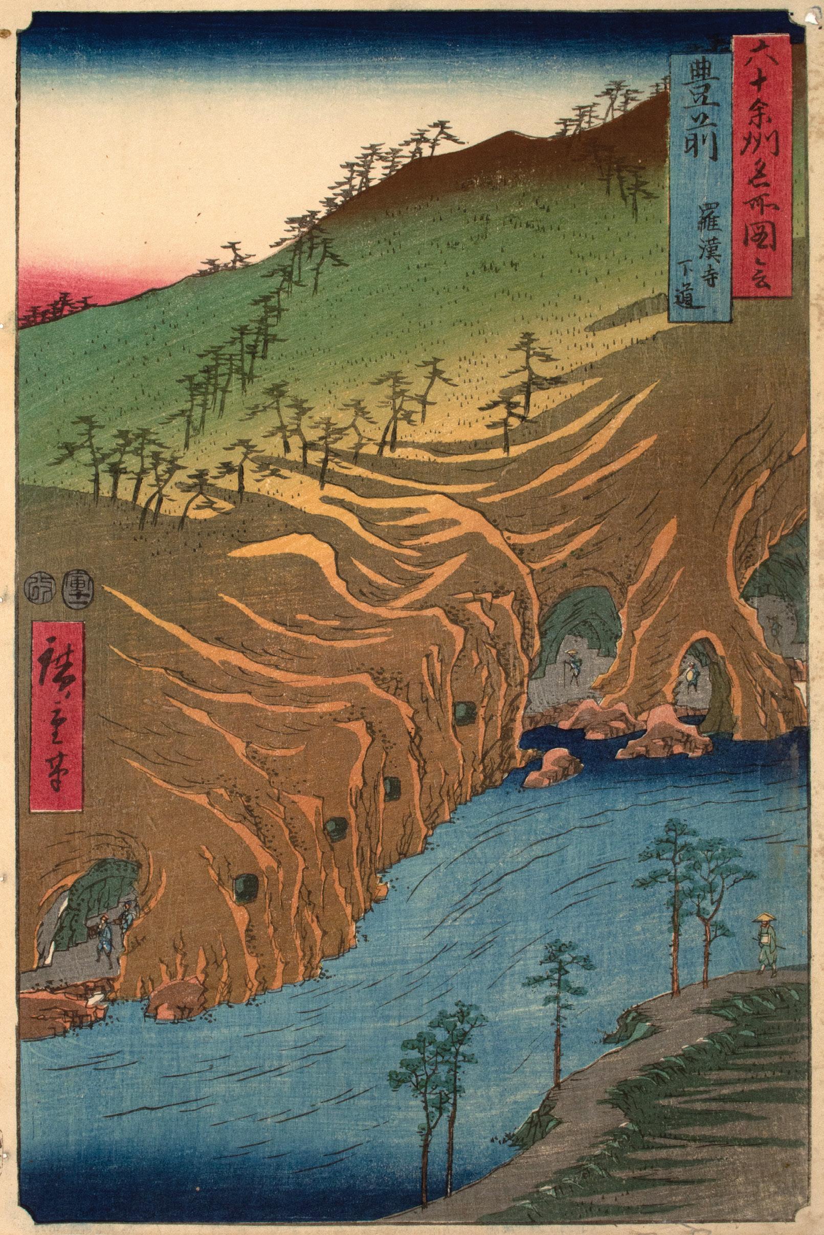
61. Buzen Province, The Passage Under the Rakan Monastery
Date: 1854
Medium: Woodblock print
Size: 14.5” x 9.75”
Publisher: Koshimuraya Heisuke
Signature: Hiroshige hitsu
Nestled in the rocky cliffside, Rakan Temple is a Zen Buddhist site that dates to the 13th century. Its caves host thousands of statues of rakan, disciples of Buddha, who are worthy or have attained nirvana. In this design, Hiroshige foregoes the temple itself to focus on the rugged caves at the cliff base. Tiny pilgrims can be seen through the many cave openings. The four square holes cut into the rock appear to serve as windows, illuminating the sculptures within. Today, the former Buzen Province belongs to northern Fukuoka Prefecture and Oita Prefecture.
62.
Date: 1856
Medium: Woodblock print
Size: 14.5” x 10.75”
Publisher: Koshimuraya Heisuke
Signature: Hiroshige hitsu
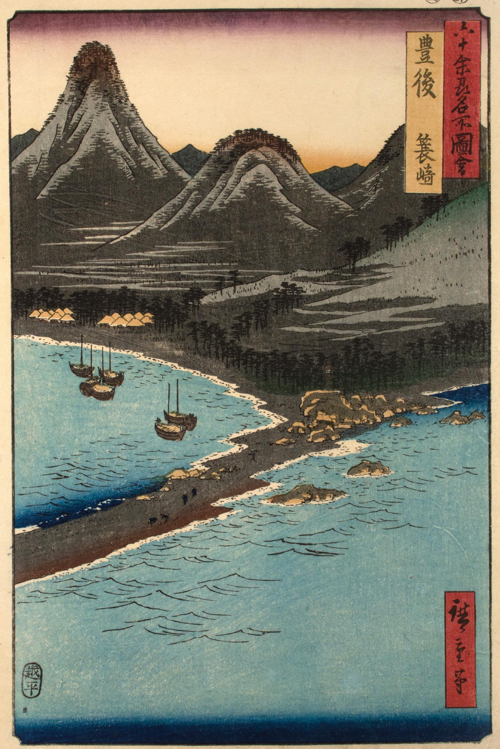
Against a mountainous backdrop, a small lighthouse stands atop the rocks near the center of the composition, guiding ships into the harbor at Minosaki. Figures dot the narrow sand spit as a waterside village nestles amid the pines to the left. Located in eastern Kyushu along the Inland Sea, Minosaki was famous for its natural beauty and busy port. In this design the printer lavishes special attention on the beauty of the mountains through overprinted shades of grey, brown, and green. Today, the former Bungo Province belongs to Oita Prefecture.
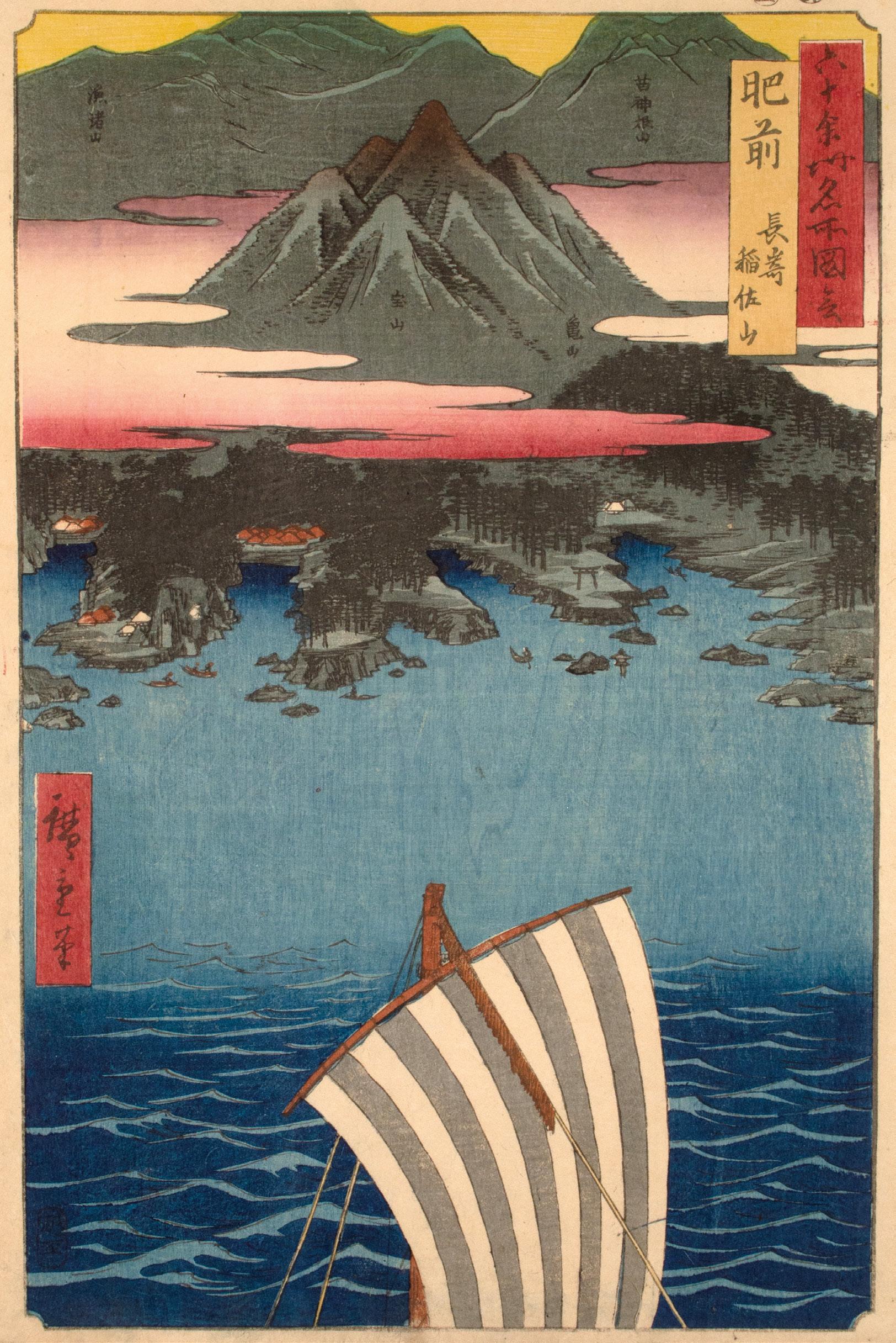
63. Hizen Province, Nagasaki, Mount Inasa
Date: 1856
Medium: Woodblock print
Size: 14.5” x 10.75”
Publisher: Koshimuraya Heisuke
Signature: Hiroshige hitsu
Beyond the striped sail, Mount Inasa rises above the bay. Beneath the blush of dusk clouds, the roofs of Nagasaki peek out from the pinecovered coast. Under the rule of the Tokugawa shogunate, Japan isolated itself from the rest of the world in a policy known as sakoku (closed country). The port of Nagasaki hosted the exception to this rule, allowing carefully monitored trade with Dutch, Chinese, and Korean merchants. Perhaps the sail in the foreground alludes to the merchant ships that frequented this port. Today, Hizen Province loosely corresponds to Saga and Nagasaki Prefectures.
64.
Date: 1856
Medium: Woodblock print
Size: 14.5” x 10.75”
Publisher: Koshimuraya Heisuke
Signature: Hiroshige hitsu
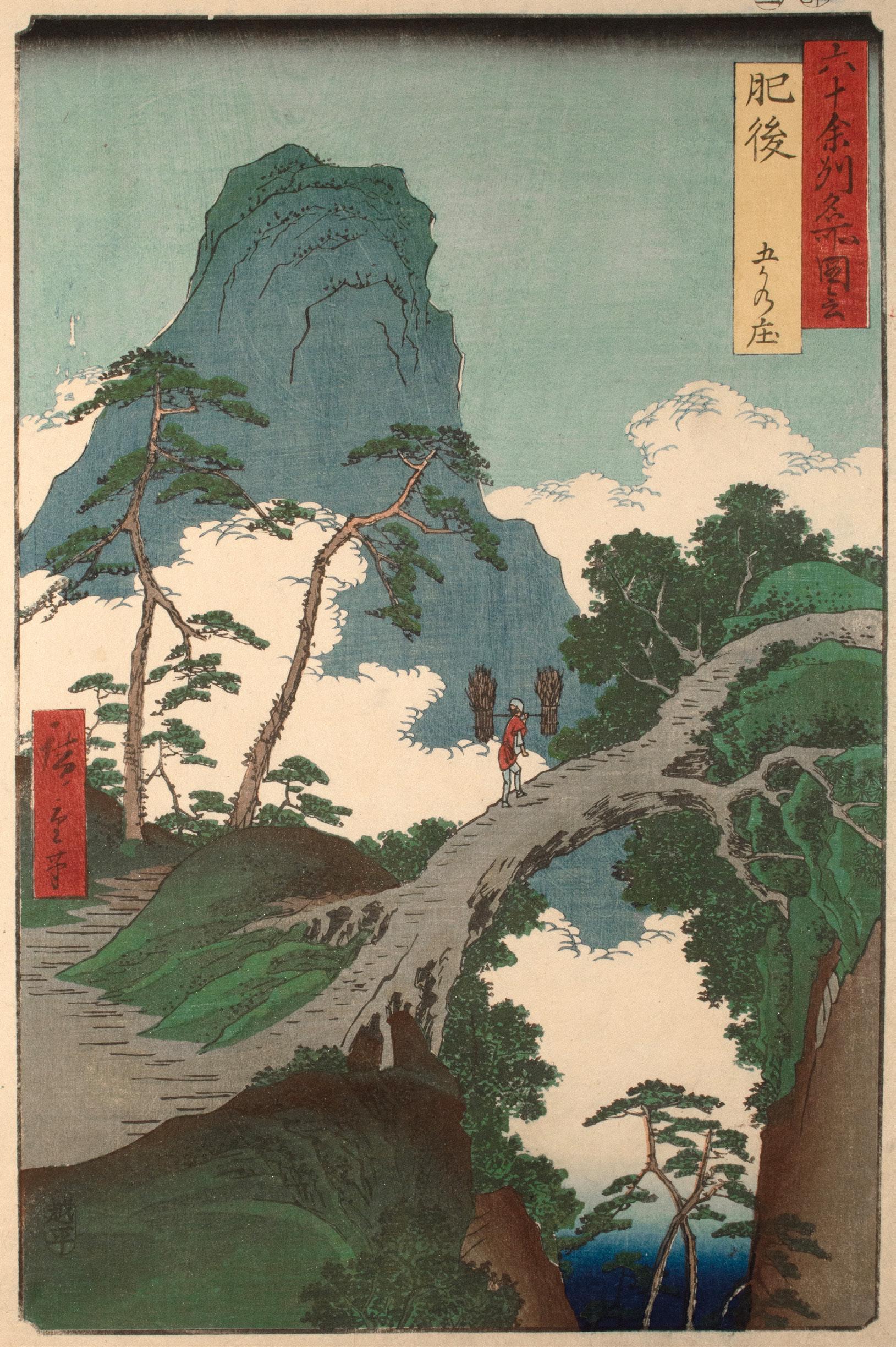
As the cloud banks roll through the gorge, Hiroshige’s view of Higo Province takes the viewer into the sky and to the five mountain villages known as Gokanosho. This remote area captured the imagination of artists and travelers over the centuries. According to legend, the area provided safe haven to surviving members of the Taira clan following their defeat by the Minamoto clan in the 12th century. A tree grows from one side of the gorge to the other and a figure carries bundled reeds across this natural bridge. This detail suggests that Hiroshige may have consulted Hokusai’s impression of the site in volume 7 of Hokusai Manga (c.1817). The former Higo Province belongs to modern Kumamoto Prefecture.
65. Hyuga Province, Aburatsu Port, Obi Oshima
Date: 1856
Medium: Woodblock print
Size: 14.5” x 10.75”
Publisher: Koshimuraya Heisuke
Signature: Hiroshige hitsu
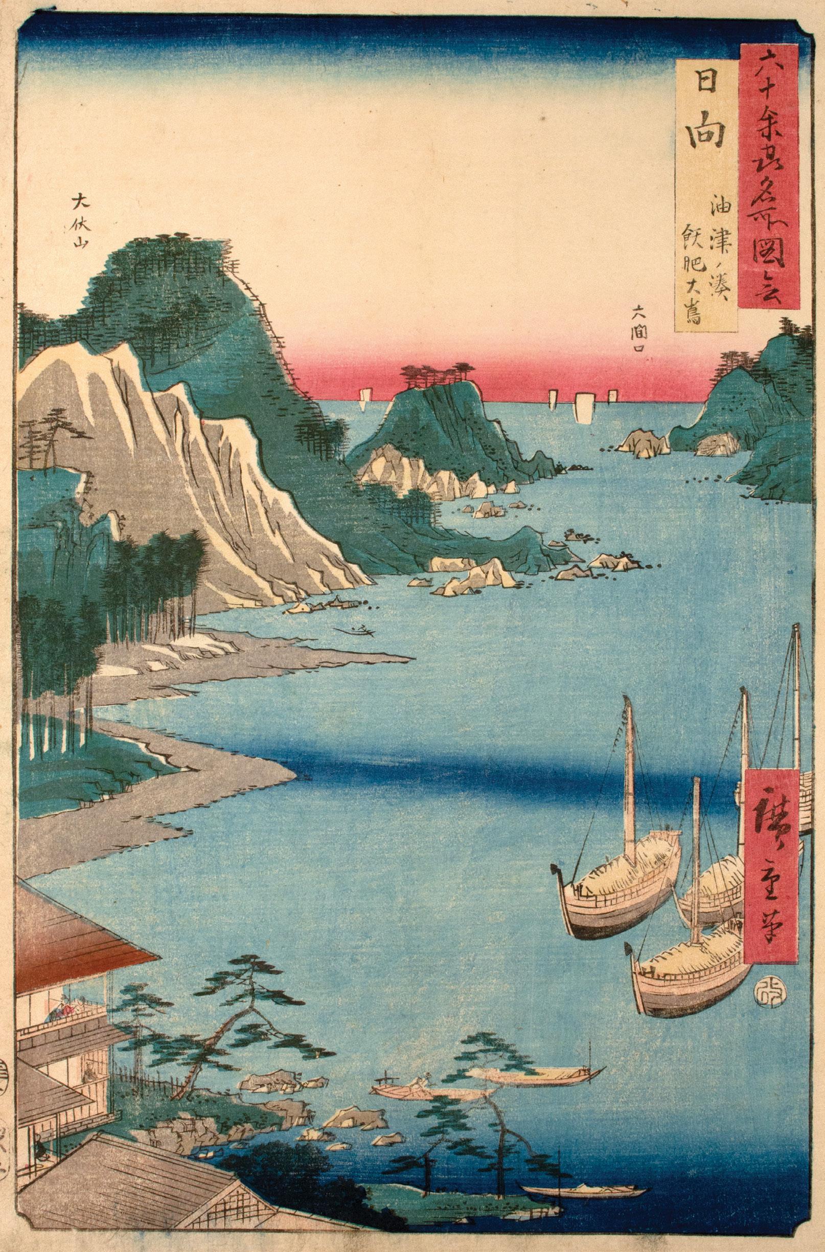
In the left corner, travelers relax on the veranda of the two-story teahouse as ships dock in Aburatsu Port. Aburatsu was known as a small but important port and fishing village. Mount Obuse rises from the water along the left edge, while Oshima (titled as Obi Oshima) sits at the right edge. The narrow waterway between the two was known as Omaguchi and served as the entrance to the port. Located in southeastern Kyushu, the former Hyuga Province corresponds to modern Miyazaki Prefecture.
66. Osumi Province, Sakurajima
Date: 1856
Medium: Woodblock print
Size: 14.5” x 10.75”
Publisher: Koshimuraya Heisuke
Carver: Yokokawa Takejiro
Signature: Hiroshige hitsu
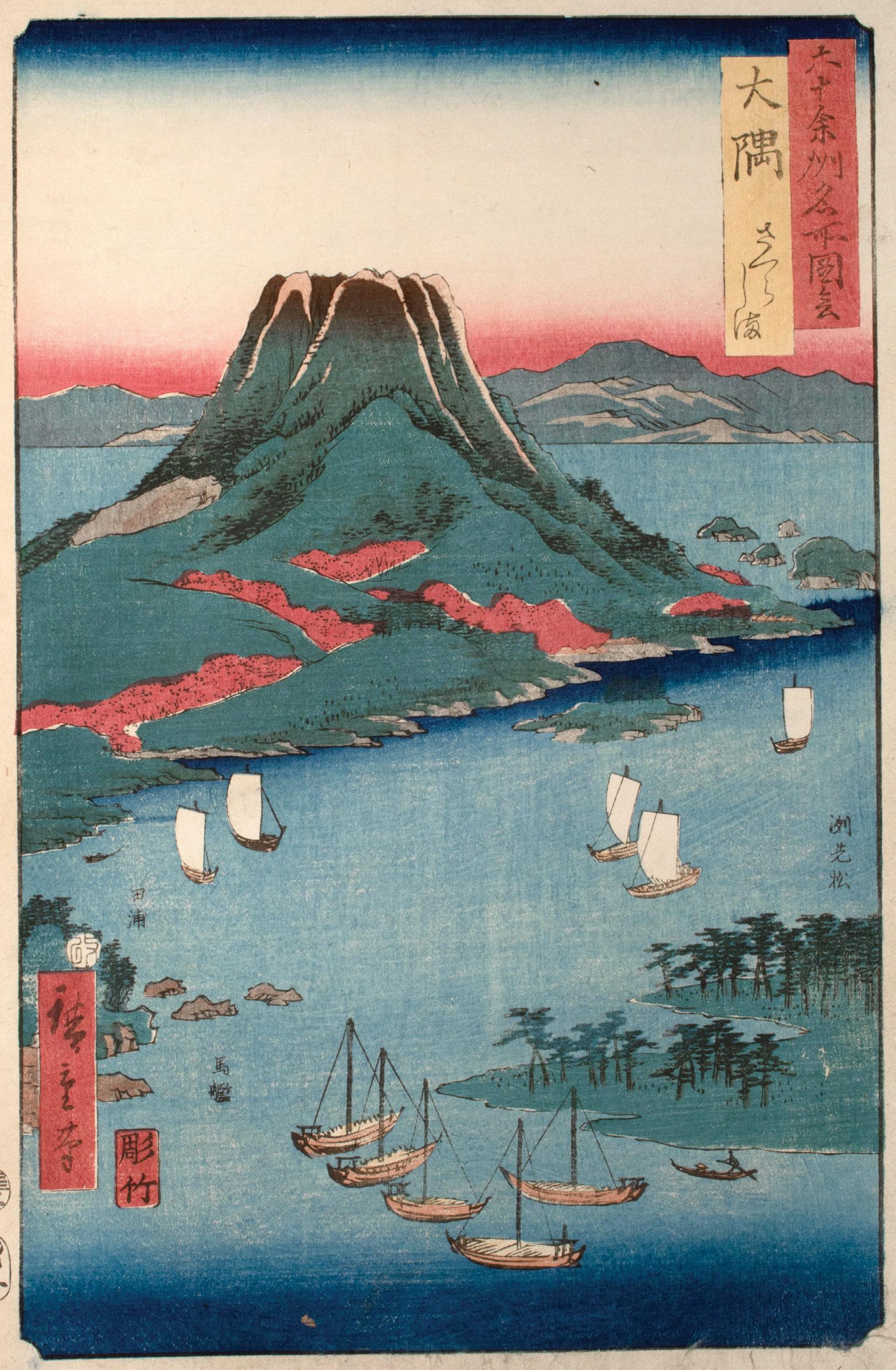
Abloom in vibrant pink, “Cherry Blossom Island”(Sakurajima) rises from Kagoshima Bay. As the island’s volcanic peak rises above the horizon, its jagged top suggests the active vent within. Sakurajima remains Japan’s most active volcano. Its eruption in 1914 connected the island to Osumi Peninsula. A painted impression of this design can be seen in the American artist James McNeil Whistler’s Caprice in Purple and Gold: The Golden Screen (1864). In it, the model Joanna Hiffernan holds this design in her hand, surrounded by other ukiyo-e and objects from Whistler’s personal collection of Japanese art.17 Today, the former Osumi Province belongs to eastern Kagoshima Prefecture.
17.
67. Satsuma Province, Bo Bay, The Two-sword Rocks
Date: 1856
Medium: Woodblock print
Size: 14.5” x 10.75”
Publisher: Koshimuraya Heisuke
Carver: Yokokawa Takejiro
Signature: Hiroshige hitsu
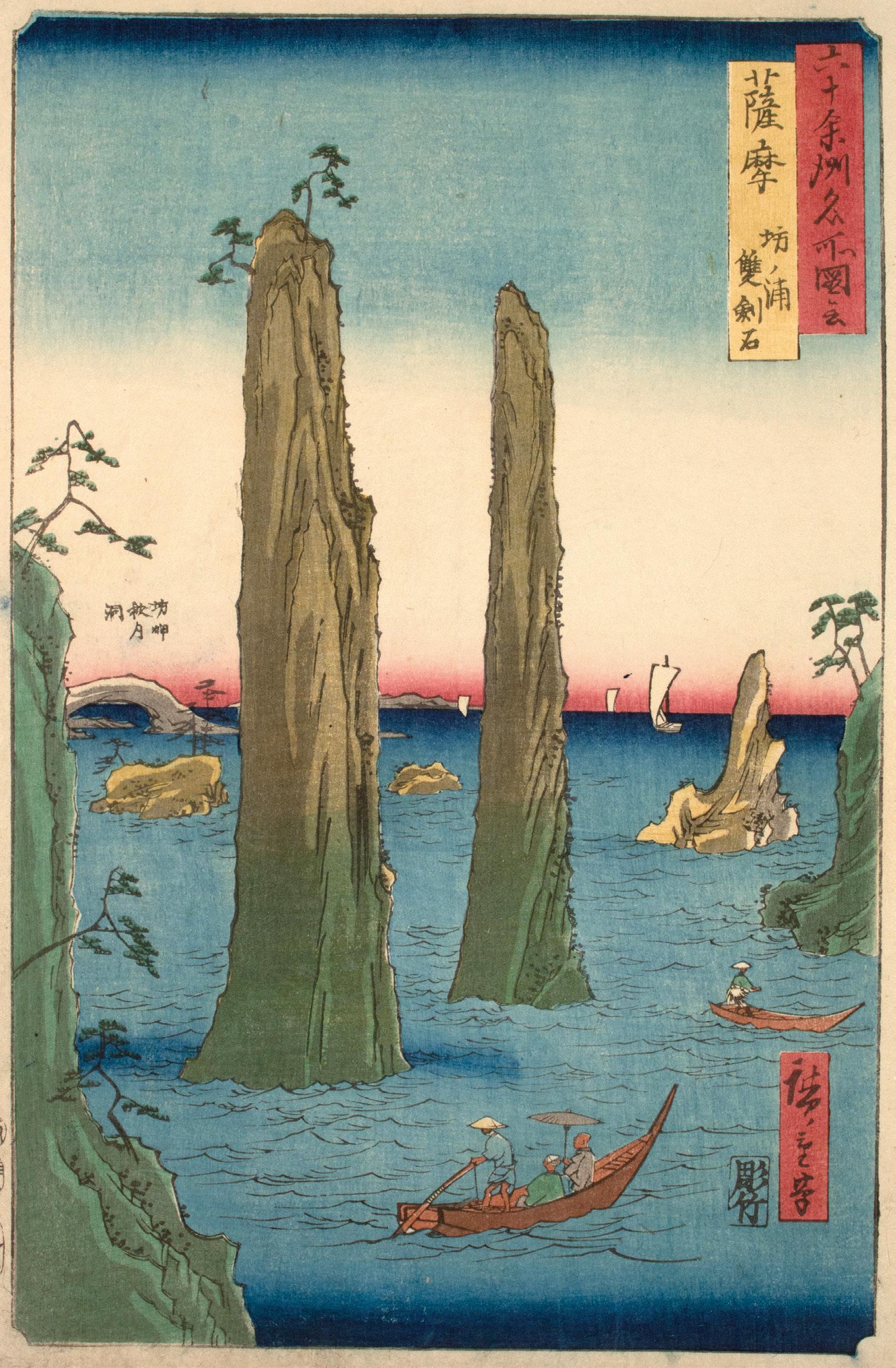
Satsuma Province was home to an unusual rock formation known as The Two-sword Rocks (Sokenseki). Located by the busy port of Bonotsu, the rock formation earned its name from its blade-like shape. If one were to visit these rocks today, it would be clear that Hiroshige took liberties in the height and shape of the rocks in the design. However, as the travelers look up from the boat in wonder at the towering stones, Hiroshige conveys the excitement of experiencing a natural wonder rather an accurate topographical image. Today, the former Satsuma Province belongs to western Kagoshima Prefecture.
68.
Date: 1856
Medium: Woodblock print
Size: 14.5” x 10.75”
Publisher: Koshimuraya Heisuke
Signature: Hiroshige hitsu
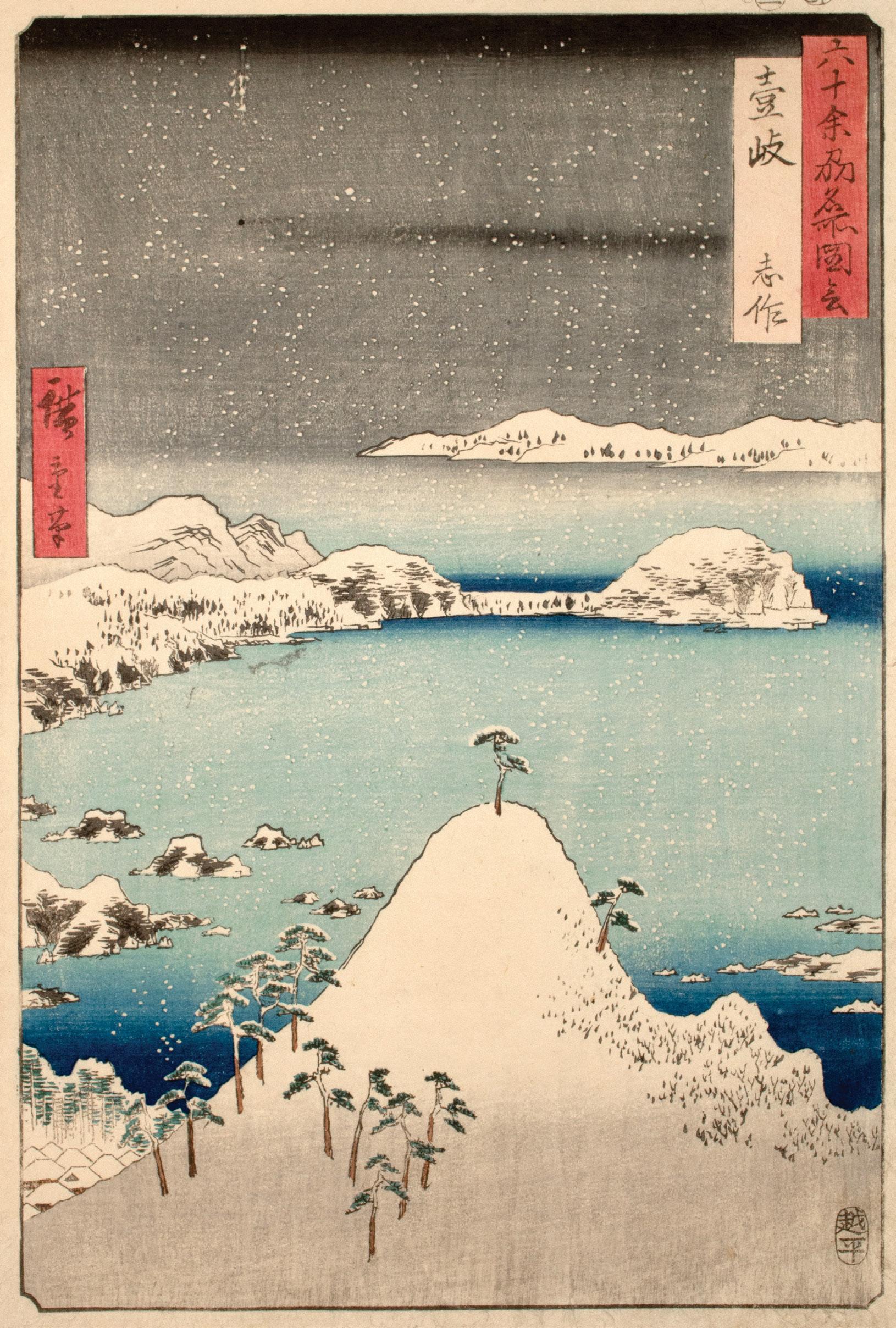
Heavy snow falls on Imari Bay as the sea fades into the night. Looking out from Kitamatsuura, the snowcovered roofs of a small village sit to the bottom left as Iki Island appears on the horizon. Though the scene evokes a winter chill, this province was typically too warm to receive such heavy snow. In this design, Hiroshige depends more on his imagination than reality, composing a scene of a seasonal beauty rarely experienced in Iki Province. Today, the former Iki Province belongs to Nagasaki Prefecture.
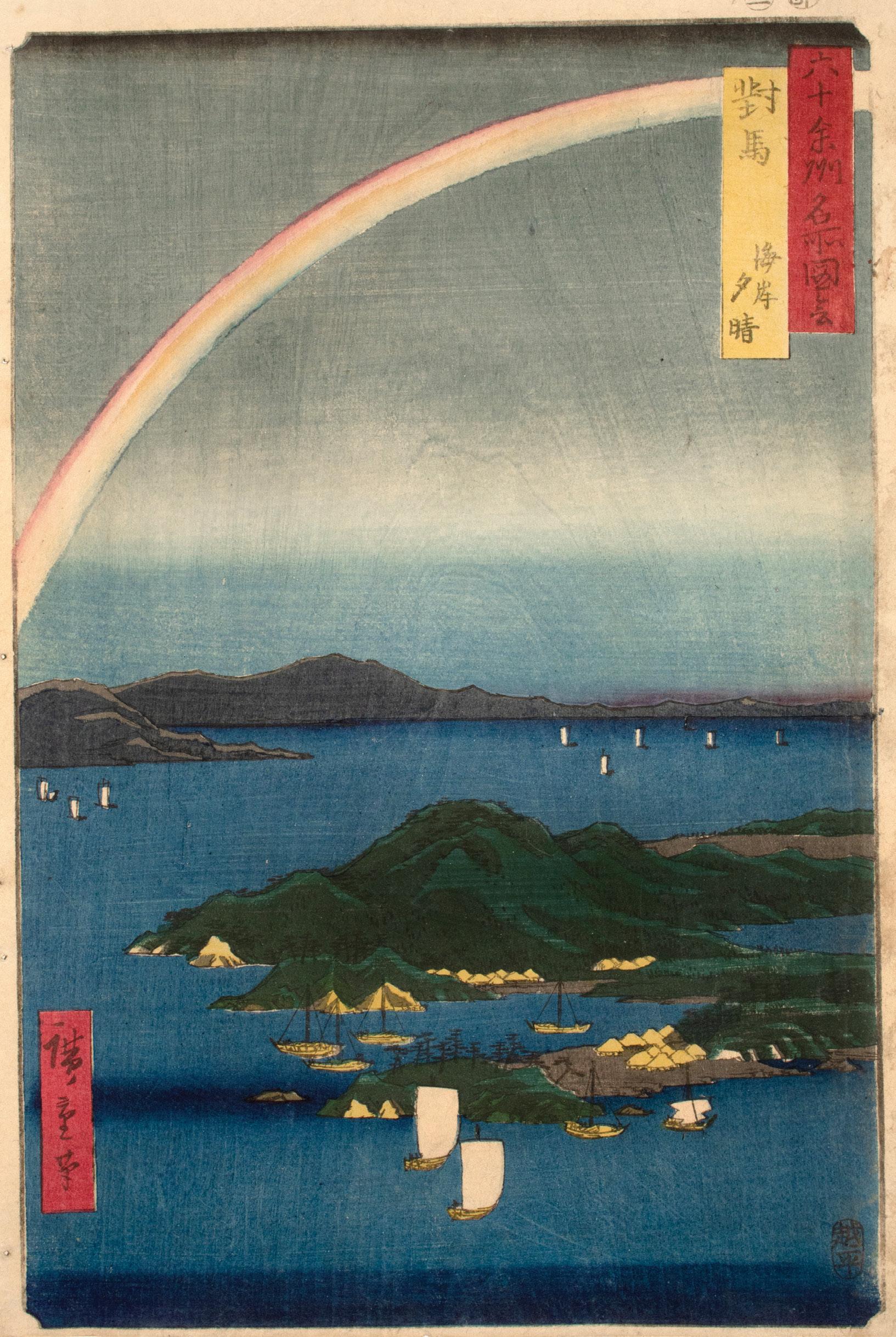
69. Tsushima Province, A Fine Evening on the Coast
Date: 1856
Medium: Woodblock print
Size: 14.5” x 9.75”
Publisher: Koshimuraya Heisuke
Signature: Hiroshige hitsu
Beneath the rainbow’s arch, the first shadows of dusk fall on the islands of Tsushima Province. Composed of the group of islands in the strait between Kyushu and the Korean Peninsula, Tsushima Province functioned as a strategic diplomatic site long before the Edo Period. During Hiroshige’s time, the islands were the center of trade and diplomacy with the Joseon Dynasty of Korea. Throughout history, the islands’ close ties to both Korea and Japan have shaped a hybrid identity that continues to this day. The former Tsushima Province corresponds to Tsushima in Nagasaki Prefecture.
Baren
Flat tool used to rub the paper against the inked woodblock during the printing process; typically made with a base of lacquered paper, core of twisted and coiled bamboo skin, and an exterior bamboo skin to secure the other two pieces together.
Bijin-ga
“Pictures of beautiful women;” a key genre of ukiyo-e.
Bokashi
Technique for tonal gradation; while multiple methods exist, most create tonal gradation on the block with a brush or rag, that is then printed onto the paper.
Edo
Precursor to modern Tokyo; cultural center of the Edo period (1603-1868) and governmental center of the Tokugawa shogunate.
Gokishichido
Eight-region system that included the region of the five provinces around the imperial capital of Kyoto ( gokinai) and the seven regions around Japan’s ancient highways (shichido): the Tokaido, Tosando, Hokurikudo, Sanindo, Sanyodo, Nankaido, and Saikaido.
Kento
Registration marks carved into the woodblock used to align each color block; the kagi kento is cut in an L-shape in the bottom right corner, while the hikitsuke kento is a straight line carved towards the left side of the bottom edge.
Kacho-ga
“Bird-and-flower pictures;” genre of nature studies; also known as kacho-e.
Karazuri
Blind printing; a line block for the desired pattern is printed without ink, embossing the pattern onto the paper; often seen in hair and textiles.
Kimetsubushi
“Uniform woodgrain printing;” achieved by roughening the color block with stiff brushes or pads to impress the woodgrain pattern onto an area of color, such as the sky or water.
Hosho
Strong and absorbent handmade paper made the fibers of the paper mulberry plant. Standard paper for woodblock prints.
Meibutsu
Famous local specialties.
Meiji Restoration
Political event where practical rule of Japan shifted from the Tokugawa shogunate back to the imperial line; marked the beginning of the Meiji period (1868-1912).
Meisho-e
“Famous place pictures;” genre of famous locations and views.
Meishoki
Illustrated travels guides.
Meisho Zue
Illustrated gazetteers featuring heavy illustration and pertinent travel information.
Sumi
Black ink; soot mixed with animal glue to form an inkstick.
Tokugawa shogunate
Military government that held practical rule of Japan during the Edo period (1603-1868).
Torii
Marks the entrance to sacred Shinto sites, often made of wood or stone.
Ukiyo-e
“Pictures of the floating world;” art form capturing the pleasure-driven, merchant-class culture that flourished in Edo during the Edo period (1603-1868).
Yakusha-e
“Actor pictures;” key genre of ukiyo-e.
Yoshiwara
Edo’s legalized prostitution district.
I would like to take this opportunity to express my gratitude to the following people for their contributions to this catalog. Firstly, thank you to Roni Neuer for your incredible work overseeing every aspect of its production–without your passion none of this would be possible. Thank you to Madison Folks for your excellent scholarly research and writing. Your dedication has brought this collection to life in your prose. A thank you to Travis Suzaka for your inexhaustible work in catalog design—I am constantly amazed by your creativity. Lastly, I am deeply grateful to Valentina Vidusin for her masterful photography, color correction, and assistance throughout.
David Libertson PresidentBryant Park Place 32 West 40th Street, New York, NY 10018
212.688.0188 | RoninGallery.com
Chairman: Herbert Libertson
President: David Libertson
Executive Director: Roni Neuer
Gallery Director: Madison Folks
Creative & Marketing Director: Travis Suzaka
Gallery Associate & Photographer: Valentina Vidusin
The Largest Collection of Japanese Prints for Sale in the U.S.