1 minute read
Behind the Rocks Trail


Phil Fergus, Leader Big Saturday, 4/16
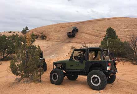
The land named “Behind the Rocks” is an elevated area south of Moab bounded roughly by the Moab Rim cliff s and the rim of Kane Springs Canyon, which is still farther south and west. This trail follows the most diffi cult routes in this region, though it gets its reputation and rating from “White Knuckle Hill”. Going down the hill is scary enough, but be prepared for a long wait and a good show while some see if they can climb it. It may be the most diffi cult hill hereabouts that is ascended with any frequency, although the frequency is diminishing as it erodes. Approximate mileages: 55 total, 35 off highway.
Scenery: The rock layers behind the Moab Rim slope downward, and a virtually impenetrable area of Navajo Sandstone domes and fi ns is in view most of the time. Canyons, including lovely Hunter Canyon, are cut into older layers. Balcony Arch, Picture Frame Arch, and a distant view of Pritchett Arch may be seen.
Road Surface: Most of the road is sandy dirt with occasional rock outcrops. To get in and out of the many small canyons involves taking a bumpy trip over sandstone ledges.
Highlights: There is a warm up hill soon after departing the highway and numerous minor canyon crossings before reaching High-Dive Canyon, so named because it is a short walk to a “highdive” pour off into a beautiful pool. The climb out is via “Upchuck Hill”. A few miles farther is “White Knuckle Hill”. All along the trail the views of nearby rock formations and the towering La Sal Mountains are exceptional. K.C. Kay & Masey Kay
(His daughter, who has always wheeled with him and is going into the military.) Thursday 4/14
Associate Leaders:
Scott Eikleberry, Dan Ence, Tanner Ence, Brook Hill, Matt Wheeler, Dan Whitman, Charles Windham.
To be used:
Thursday 4/14 and Big Saturday 4/16