24 minute read
1.5 DPSIR: Drivers, Pressures, State, Indicators and Responses


Finally, in delving into this process we also decided to “translate” the mined data into maps depicting the complexity of the social-ecological system. For that process, we used the cartographic data on the submerged habitats of La Parguera produced by NOAA’s Biogeography group, and placed the information produced by this analysis in a geographical and ecological context, producing a view of the La Parguera’s seascape and its complex network of processes.
1.2 The People in the social-ecological system
The human agency, central to the analysis of the system (as a force that shapes landscapes and seascapes over time, and put into motion the stressors that contribute to the current status of the system), is also responsible for producing two critical processes: social legacies and social memory. Social legacies are “the lasting effects of past events affecting current conditions”, and social memory refers to “the collective memory of past experiences that is retained by the groups” (Chapin et al. 2009). Here we argue that the current system of responses to the current status of the system, the governance, is conditioned by the obstacles imposed by an adversarial legacy of contested visions and actions, among the stakeholders that is capable of derailing conservation efforts. Ironically, the social memory, interpreted as the knowledge built by humans and conceptualized as traditional and local ecological knowledge, also has the potential of contributing to the resilience of resource users and their communities, and could build the appropriate mechanisms for local collaborative forms governance, such as co-management. In La Parguera, for example, fishers, and their network-based community (as opposed to a placed-based community, are threatened by social change and development, that take the form of coastal gentrification, or the displacement of the local population by new forms of living, social classes, and architecture (Brusi 2008, Griffith et al. 2007). In facing that pervasive process in all coastal areas of the United States and its territories (Jacob et al. 2010, ValdésPizzini et al. 2010), the fishers and local residents may be able to keep their coastal and piscatorial identity, through the local ecological knowledge they assembled and shared over three centuries (Valdés-Pizzini and García-Quijano 2009).
1.3 The stakeholders’ perceptions of the ecosystem: A methodological note on the Damage Schedule
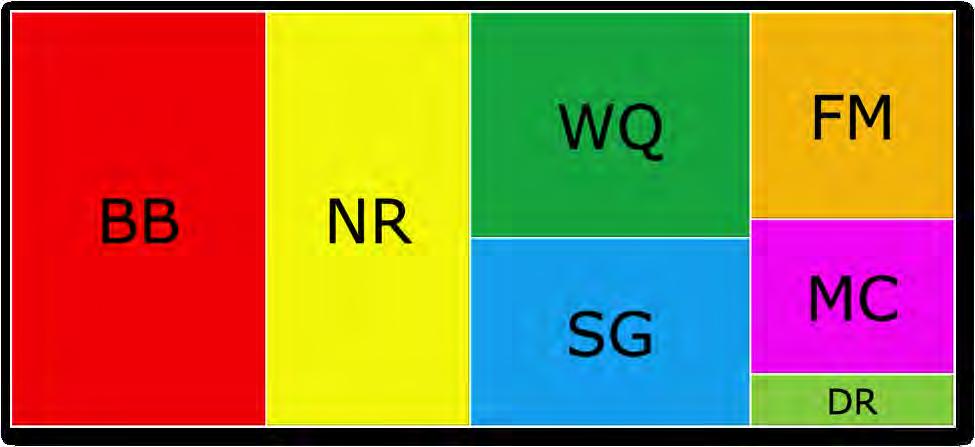
The social-ecological system provides backdrop based on the notion that we are dealing with “complex adaptive systems” that “enable us to study the integrated nature of the system but recognizes legacies of past events and path dependence of human agency as fundamental properties of the model (Chapin et al. 2009). Such approach is also flexible in terms of the use (and value) of both, quantitative and qualitative data. Humans are an essential component of the system that also provides assessments (based on research, opinions, experiences, observations) of the status and conditions of the environment. In this document we use all the available information on the conditions of the habitats and species at La Parguera, but also include the perceptions of the stakeholders, in relation to those “habitats” impacted the most, and their stressors, through the use of the damage schedule technique developed by Ratana Chuenpagdee et al. (Chuenpagdee et al. 2001 a, b). Consultation with stakeholders to identify a manageable number of variables and processes is essential to define the social-ecological system. Damage schedule allows us to have a clear view of the perceptions that the stakeholders have of the human activities that impact the habitats and a ranking of those habitats and activities, as per their importance. We employed this method, devised by Chuenpagdee et al. (2001 a,b), and applied them to La Parguera. In this section we present the results of the damage schedule, indicating the habitats that the respondents felt were affected the most by anthropogenic activities, and a ranking of those activities, in order of importance. Data from the damage schedule is also used in the development of a composite of the conservation goals and objectives. This method measured the perceptions of 121 stakeholders interviewed in La Parguera (2005-2006) regarding the impacts upon a set of habitat types and the threats that impact them. The damage schedule method utilizes a paired comparison to elicit a choice of which of the two options is most important in order to value judgments of local stakeholders that could be used to gauge the significance of potential environmental damage (Chuenpagdee et al. 2001 a,b). The first set of comparisons was specific towards choosing the most impacted or degraded of 7 habitat types (Figure 1). The second set of questions was designed to identify the activities that posed the greatest threat to marine ecosystems of La Parguera (Figure 2). The stakeholders interviewed for this exercise included permanent residents, business owners, scientific community, commercial fishers, and a group considered part of the ‘floating population’ of La Parguera.
BB=bioluminescent bay NR=near shore reefs WQ=water quality SG= seagrass FM=fringing mangroves MC=mangroves on keys DR=deep reefs
Figure 1. Proportional representation of the ranking of habitats that were most impacted in La Parguera (abbreviations are listed in order of importance).
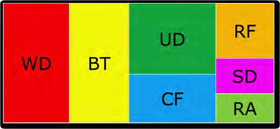
WD=waste disposal BT=boat traffic UD=urban development CF=commercial fishing RF=recreational fishing SD=SCUBA diving RA=research activities
Figure 2. Proportional representation of the threats that ranked highest in La Parguera (abbreviations are listed in order of importance).
A correlation analysis of the different rankings resulting for each sub-group of stakeholders demonstrated accordance between most, except the commercial fishers and the scientific community in the ranking of the most impacted habitats (Table 1) and threats (Table 2). Another significant difference was seen between the ranking order of habitats and threats between the scientific community and the ‘floating population’. A higher value was given to seagrass by commercial fishers, which wasn’t very high ranking by the scientific community.
Table 1. Correlation analysis of ranks for most impacted habitat type, significant differences in red.
Commercial Fishers Commercial Fishers Scientific community
1 Business owners & tourist operators Permanent residents “Floating” population Resource managers
Scientific community
Business owners & tourist operators
Permanent residents
“Floating” population
Resource managers
0.25
1
0.67857 0.67857 1
0.82142 0.60714 0.96428 1
0.85714 0.5 0.89285 0.96428 1
0.75 0.71428 0.85714 0.92857 0.89285 1 Table 2. Correlation analysis of ranks for most significant threats to La Parguera habitats, significant differences in red.
Commercial Fishers Commercial Fishers Scientific community
1 Business owners & tourist operators Permanent residents “Floating” population Resource managers
Scientific community
Business owners & tourist operators
Permanent residents 0.28676 1
0.74560 0.67857 1
0.86030 0.60714 0.96428 1
“Floating” population 0.91766 0.5 0.89285 0.96428 1
Resource managers 0.74383 0.55901 0.72672 0.83852 0.83852 1
1.4 Governance and the Social-Ecological System
One of the key concepts in this report is governance. We trace the trajectory and legacies of the governance system in place in La Parguera since the 19th century. Here we use the following definition:
“Governance is the whole of public as well as private interactions taken to solve societal problems and create societal opportunities. It includes the formulation and application of principles guiding those interactions and care for institutions that enable them” (Kooinman and Bavinck 2005).
For Kooinman and Banvick, in their seminal article in the introduction of the book Fish for Life: Interactive Governance for Fisheries (Kooinman and Banvick 2005), the process of governance is a dynamic process that involves both, public and private actors who share an interest in a resource or a space (in this case, the coral reef ecosystem), actors who could work together to solve the problems at hand. Governance is not an exclusive realm of the state and the government, and could (in some modalities) incorporate other stakeholders in the
design and implementation of policies and actions. Thus, governance is an inclusive process that incorporates policy and management activities, and we add, the science and knowledge that produce them. Such conceptualization of governance views it as “a widely practiced activity and a broad responsibility” among many potential actors (Ibid.). Governance also comes in many forms and shapes. Kooinman and Banvick reduce the number to three fundamental options: (1) Hierarchical: a unilateral, top-down relationship between the State and the citizens, which is—and has been—the dominant mode in Puerto Rico and in La Parguera; (2) Self-governance: when actors rule themselves with little, if any, participation from the government, which may be the de facto form of governance in La Parguera, and (3) Co-governance: an ideal form for many stakeholders (see Mahon et al. 2011) in which the actors (from the private and public sectors) collaborate, and “join hands with a common purpose in mind” (Kooinman and Banvick 2005). In assessing a social-ecological system, governance is essential, since it has to face the challenge of managing for environmental (ecological) and human (social) goals and objectives at unison. For example, in fisheries, governance must provide the tools and mechanisms for the conservation of populations, stocks and the health of the ecosystem, while procuring social justice, sustain livelihoods and employment, provide food security and safety (see Kooinman and Banvick 2005) and protect the social integrity and identity of coastal communities, as in the case of the United States (Valdés-Pizzini et al. 2010). Future actions (research, design and implementation of policies and regulations) for La Parguera must take into consideration the social legacy of governance, and an understanding of the path dependence, that is, the relationship between the current conditions and the history of contentions, as well as the human agency (actions) responsible for the current state of the ecosystem.
1.5 DPSIR: Drivers, Pressures, State, Indicators and Responses
The construction of a social-ecological system model requires a number of exercises and analyses, to understand the complexity of variables that shape the landscape and the seascape at different temporal and spatial scales. Here we use, as a framework, the identification of the DPSIR. This model was developed by the European’s Organisation for Economic Co-operation and Development (OECD), and quickly became a preferred tool to understand human actions and environmental impacts in a diversity of contexts (Mangi et al. 2007). Over the past 25 years a number of environmental organizations worldwide (e.g., The World Wildlife Fund and the World Bank) tested a number of conceptual frameworks to deal with environmental change, as a product of human agency. In recent years, a number of scientists, practitioners and resource managers have taken the DPSIR framework as a useful tool to understand such processes in coastal, marine and estuarine habitats and ecosystems. The application of the DPSIR conceptual framework requires an interdisciplinary approach and methodology by which environmental and social scientists “jump together” into the analysis of the processes under review. A full-fledged DPSIR requires a sophisticated data gathering process, and even the design and implementation of field research activities to construct quantitative databases that sustain the indicators of the effects that pressures impinge upon the environment. An integrated assessment of any ecosystem requires a well-laid, and funded, research program to identify and analyze the variables of the DPSIR, on different spatial and temporal scales. However, in absence of that process, researchers and resource managers depend on the analysis of the available information, which seldom is gathered, constructed and analyzed in a manner appropriate for a full quantitative analysis of the indicators of the status of the environment. Another dimension of a DPSIR is the systematic consultation of the stakeholders to appraise their views on the ecosystem, namely: their knowledge, experiences and perceptions on the habitats under duress, the human activities that impact the biotic and abiotic conditions and dimensions, the root causes of those human activities, the different ways in which the impacts could be measured (via indicators), and the historical steps taken by society to respond to those environmental conditions. The consultation of the stakeholders must also provide researchers with their views on the goals and objectives for the ecosystem, which theoretically could set the parameters for the potential array of actions that could be taken by society to address the environmental issues identified. As stated earlier, for this effort we did not engage in any data gathering activity, nor did we consult the stakeholders on any aspect related to the DPSIR, except for a brief participation in a DPSIR exercise for the Guánica watershed that connects with La Parguera ecosystem, and a panel consultation with CRES and CCRI researchers on the physical, biological and scientific (the existing literature) dimensions of the ecosystem. Also, we analyzed a previously collected data set, amenable for a Damage Schedule (Chuenpagdee et al. 2001 a, b). As a result, we have the analysis of 123 interviews that offer a proxy for the perceptions of most stakeholders (community members for the parcelas, marine science students, researchers, recreational service providers and visitors), on the most critical habitats that deserve the attention of the authorities, and the pressures impacting them. In addition, we extracted from the primary and secondary sources that we examined, the views of a number of stakeholders (scientists and community members) on the key problems impacting the ecosystem and the goals and objectives. While we do not have adequate source of information on the majority of the stakeholders of La Parguera, we do have—as a result of the CRES and CCRI projects—an accurate view of the fishers, through interviews with key informants with high levels of LEK, and information on the fishers and managers perceptions on the regulations and management practices, through a series of focus groups (Valdés-Pizzini and García Quijano 2009). Unless heavily funded, most efforts to identify the key variables involved in a DPSIR are based on the examination of existing data (and its “adaptation” to the requirements of the framework), or the use of a small panel of experts to identify the variables and processes. Mangi et al. (2007) examined a number of published and unpublished sources—including anthropological studies—to identify the drivers and pressures impacting the Kenyan reef fisheries, and to describe the economic and sociocultural context of their predicament, and the indicators of their status (e.g. low coral cover, fishing down the food web, an increase in the population of coral boring sea urchins), the barriers to change, and the gaps in the information (Mangi et al. 2007). The study also identified the policy actions (legislation, regulations, outreach programs) in response to the decline in the stocks (Mangi et al. 2007). Rehr et al. (2012) applied a “decision support framework for science-based multi-stakeholder deliberation” in the case of Florida coral reefs. Researchers used a panel of experts (n=9) to elicit the information needed to apply the DPSIR conceptual approach to the Florida Keys. A more comprehensive analysis is expected with the incorporation of a larger number of participants representing the diverse stakeholders (Rehr et al. 2012). In our case, we used a variety of sources, and explored the perceptions of a larger number of stakeholders through data already collected by the CCRI and CRES projects. In the future, a more precise integrated assessment of the La Parguera ecosystem will require a systematic study of all the stakeholders.
In essence the definitions of each of the main pillars of the DPSIR are summarized below. Drivers (also identified in the literature as root causes) are those factors (anthropogenic or natural) that cause change in certain components of the system. They are the main process (societal or natural) that develops into a series of actions that result in changing the environment. Human drivers are usually the result of decision-making processes, policies, and human actions at the top level (political, cultural, economic) of the system. Pressures are specific factors that can be traced (in terms of origin) to the root causes. For example: population growth in the rural areas of the southwest coast is a major driver in La Parguera that promotes a number of human activities that results in pressures (deforestation, expansion of the human footprint) impinged upon the habitats and the species. State refers to those variables that provide information to stakeholders and scientists on the conditions or the present status of the environment. For example: changes in the population densities of dinoflagellates in the bioluminescent bays, or the presence of heavy metals in the nearshore reefs.
Impacts refer to the changes that occur in the state variables that modify the conditions of the environment, species or ecosystem relationships and therefore are critical to the health of the ecosystem. In La Parguera we may find a decline (measured in many different ways) in water quality (considered by scientists as a major element of the ecosystem) that may have contributed to an impact measured in an increment in detrimental conditions and pathologies affecting coral reefs. Impacts must be evaluated in terms of the management objectives. For example, one of the objectives noted by the stakeholders was the protection of the coral reefs and to improve water quality in the near shore areas. Therefore, the objective (in terms of the DPSIR) may be to reduce the potential for diseases and conditions, by controlling human activities and their impacts. These actions translate in the conceptualization of the DPSIR into responses. Responses are those actions (decisions, conservation measures, design and implementation of regulations, and enforcement) taken to reduce the impacts by controlling those human activities changing the state variables. In the case of natural events (as drivers), the responses are focused on restoring habitats or populations impacted by those events. An in-depth description of the social-ecological system for La Parguera must start with this information that could be conceptualized into a DPSIR model for each habitat or population under scrutiny. For this SES we developed two models: coral reefs (Appendix 1), and bioluminescent bays (Appendix 2), based on the information used for this report. In these two examples the drivers identified are essentially the same. The population growth in the region has led to the transformation of some agricultural lands into urbanizations and developments for first and second homes. In addition the Lajas Valley supports intense agriculture, which was also identified as a driver for these two cases. Finally tourism and recreational activities are continually conducted in La Parguera due to the marine resources that attract boaters, visitors and foreigners. The pressures that are brought about by these drivers include the direct actions on the lands of the watershed of La Parguera such as deforestation that can lead to increased sedimentation, road and cement developments that reduce the area of water absorption by the soil and alter the natural drainage of the watershed. These urban and commercial developments increase the use of chemicals and also generate vast amounts of nutrients and debris that end up getting into the wetlands, shore and sea. Increased visitation to the cays and offshore reefs by boaters increases the chances of groundings and other direct impacts to the benthic habitats. In the case of the bioluminescent bays the increased visitation may have consequences that affect the bioluminescence due to resuspension of sediments or contamination by petroleum products as well as the impaired appreciation of the phenomenon due to light pollution. Finally the extraction of marine organisms (lobster, conch, fish, sea cucumbers, etc.) is also a direct pressure driven by increased human population in the area. These pressures have propelled the state of the resource to a less productive or ecologically impaired situation. The increase in erosion rates (500 times higher) sedimentation and nutrients has led to the increase in algae that have competed with corals and now dominate many of the hard substrata of coral reefs. The contaminants coming from the coastal development activities have been detected in nearshore corals. In the case of the bioluminescent bays water quality detrimental to the dinoflagellates responsible for luminescence such as nutrient enrichment and hypoxia have been documented to negatively affect this important attraction. The impacts that have resulted form these changes in the state of the resources include direct damage to shallow benthic habitats by vessels and debris, reduction in the live coral on reefs, increased disease prevalence and mortality. In the case of the bioluminescent bays the impacts can be detected in decreases in dinoflagellate populations, chages in the productivity of mangroves and seagrasses of the bays as well as high sediment accumulations that affect bioluminescence.
Some of the responses to these impacts that have been identified in La Parguera include the enactment of regulations to reduce the pollution and sedimentation to the local waters, the creation of a water treatment plant that does not discharge into the waters of La Parguera directly as well as the implementation and enforcement of existing environmental regulations and laws including the special planning area of La Parguera. In the case of the bioluminescent bays the acquisition of the lands of the watershed surrounding the bay has been a response to the impacts associated to land use patterns. In our analysis of available literature for La Parguera we identified (and constructed for this exercise) the goals and objectives acknowledged by stakeholders. Please note that some objectives are contradictory, or opposite to other objectives presented by different stakeholders. In order to describe the social-ecological system, stakeholders are also consulted to establish the conservation goals and objectives needed to maintain the system or to restore portions of it. Based on the identified components of the DPSIR, researchers are able to establish—jointly with the stakeholders and participants in the process—the goals and objectives that society has for the ecosystem. In our data mining process, we explored the many discussions that stakeholders from La Parguera had on the present and future of the area and their proposals for conservation and restoration of a number of habitats. Government agencies, NGOs, scientists, resource users, visitors, fishers, and community members have a long history of debates, confrontations and contentions on what is best for La Parguera. In our exercise, we used the results of the damage schedule, as well as interviews, field notes, letters, position papers, public depositions, and reports to create a composite of the conservation goals and objectives.
1) The protection and conservation of the biotic and abiotic components and resources of La Parguera for the benefit of the environment; that is, the natural and socioeconomic components of the social-ecological system. 2) The open access to La Parguera’s natural resources with minimal, but effective, intervention from government agencies (Federal and Commonwealth). Objectives: 1. To protect the integrity of the bioluminescent bays1
2. To protect coral reefs.2
3. To develop and implement a resource management system that includes the input of the stakeholders and respects the recommendation of the users 3
4. To protect the fishery resources while allowing sustainable catches of commercially important species 4
5. To develop and implement no-take zones in La Parguera5
6. To avoid the implementation of no-take zones in La Parguera 6
7. To develop and implement a plan for the conservation of coastal and marine resources in a manner that protects the economic integrity of stakeholders 7
8. To allow the continuation of the stilt houses (casetas) in a sustainable manner and their contribution to management through fees 8
9. To eliminate the casetas and restore the patrimony of the maritime zone9
10. To develop and implement an educational plan for La Parguera residents and stakeholders on the ecosystem and the importance of conservation 10
11. To enforce environmental regulations in a democratic manner that takes into consideration malpractices in the terrestrial area, as well as in the coastal-marine area
1 Documents of the Department of Interior and the Puerto Rico Conservation Trust. 2 Damage Schedule Report. 3 La Parguera, armonía entre mar y tierra. A pilot plan for the management plan. April 20th, 2007. 4 Interviews with fishermen. Focus group with local fishermen, June 22, 2004. 5 La Parguera, armonía entre mar y tierra. 6 Meetings and interviews with fishers. Case studies discussed in Valdés-Pizzini 2009, CRES Report, 7 La Parguera, armonía entre mar y tierra. 8 Ibid., Colón Carlo (2005). 9 Meeting with fishermen from Pitahaya to Guánica, May , 2009. 10 Ibid. 12. To reduce the impact of boaters and resources users on the cays and coral reefs through a mooring system and the selection of an area for heavy use11
13. To restore the littoral area for aesthetic and conservation purposes12
14. To improve the water quality of the neritic zone through controls of the disposal of wastewater and reduction of sediment loads 13
15. To incorporate stakeholders into the design and implementation of management plans (conservation, education, research) for La Parguera 14
16. To protect the integrity of the Special Planning Area, through planning, law enforcement, and implementation of regulations and conservation programs that limit development in the area 15
11 Otero and Carruba 2006, Vicente et al. 2008. 12 Plan de Manejo del Área de Planificación Especial de La Parguera. 13 Krausse 1994, 14 Valdés-Pizzini 1990, Fiske 1992, Krausse 1994. 15 Ponencia ante la Asamblea Municipal de Lajas, del Comité Vecinos Unidos de La Parguera. October 1, 2001.
Chapter 2 – A Timeline of Human Interactions: The Shaping of the SocialEcological System
2.1 Geographical Setting
The southwestern coast of Puerto Rico is characterized by coastal plains at the southern extent of the westernmost tip of the ‘Cordillera Central’ or central mountain chain. The southwestern coastal municipalities range from Cabo Rojo on the western extreme to Ponce. Three municipalities make up the southwestern most corner of the island (Cabo Rojo, Lajas and Guánica). These areas are part of a coastal ecosystem corridor that extends eastwards from the western coast of the Cabo Rojo municipality along the southern coast of the island (Figure 3).
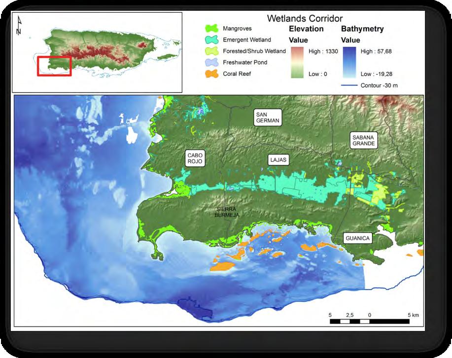
Figure 3. Southwestern Puerto Rico corridor of wetland and marine habitats (map by M. Schärer).
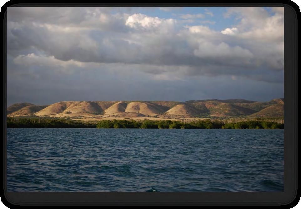
The low hills of the Sierra Bermeja “vermillion hills” (Figure 4) formation extend from Cabo Rojo to Lajas and separate the south facing coastal plain from low-lying areas to the north. Sierra Bermeja covers approximately 1,537 ha (15.37 km2) with elevations ranging from 15 m to 301 m above sea level, and lies on 195 million-year-old serpentine rocks considered the most ancient rocks of the Caribbean plate (Montgomery et al. 1994). Red-ribbon chert rock is abundant and gives Sierra Bermeja its name due to the reddish tinge of the terrain. To the north of Sierra Bermeja the Lajas Valley includes a variety of habitats including wetlands as well as areas of intensive agricultural use. The wetlands compose a drainage corridor that connects the now extinct Guánica Lagoon with the Lajas Valley and exit into the Boquerón Bay in Cabo Rojo. These wetlands serve as critical habitat to a variety of aquatic and migrating bird species threatened by different factors including habitat loss and degradation, housing and industrial development, invasive species such as patas monkey (Erythrocebus patas) and rhesus macaque (Macaca mulatta), soil and water pollution, diversion of runoff, and human disturbance (Méndez-Gallardo and Salguero-Faría 2008).
Figure 4. Sierra Bermeja hills west of La Parguera, Lajas (photo credit M. Schärer).
This study focuses on the coastal ecosystem of La Parguera, which extends beyond the Lajas municipality coastal limits. This ecosystem is composed of the habitats that occur on the areas south of Sierra Bermeja including areas of the Cabo Rojo and Guánica municipalities as well as the complete Lajas coast. The terrestrial area is characterized by soils of volcanic origin, a limestone formation, and the presence of xerophitic vegetation dominated by low precipitation and high temperatures. It is located within the subtropical dry forest life zone, with an annual rainfall of 600-1,100 mm (Ewel and Whitmore 1973). Despite a general pattern of low precipitation, heavy rains and tropical storms have a direct impact on the soils by eroding and transporting sediments and nutrients to the coastal habitats and waters. Some of the terrestrial habitats found in this area are forested with dense woodlands including secondary forests, ravines with higher stands of vegetation, open areas of low-density woodlands consisting of current and abandoned cattle pastures as well as intermittent ponds used in cattle-ranching activities (Aukema et al. 2006). Adequate vegetation cover on steep slopes (the most susceptible to erosion) and along riparian corridors reduces the effects of flooding and protects soils from erosion. Because the terrestrial areas north of the coast are under a dry and seasonal precipitation regime, soils do not absorb large amounts of rain quickly, which can cause flash floods and erosion.
The watersheds facing south towards La Parguera have the potential for generating increased sediment loads towards the wetlands and submerged habitats due to their land use and development (Hertler 2002). Sediment cores taken from La Parguera Bay demonstrated a significant increase; almost double the sediment settling rates, over the past 70 years (RyanMishkin et al. 2009). Sediment production rates were measured on unpaved roads in the La Parguera watershed by (Ramos 2010), and results demonstrate that sediment production rates on roaded surfaces in La Parguera are 15–50 times higher than analogous undisturbed surfaces, and changes in vegetation cover also might have played a role in declining sediment production. The conclusion of this study was:


