SENA KELEŞOĞLU
EDUCATION
2021-2024
Politecnico di Milano
Landscape Architecture and Land Landscape Heritage
GPA: 3.6/4.00
2017-2021
Bilkent University
Landscape Architect Urban Designer personal.
COMPETITIONS

WORK EXPERIENCE
EXTRACURICULAR ACTIVITIES
WORKSHOPS
03.11.1997
Born in Turkiye
Currently living in Milan, Italy
Conducted studies in areas showing different characters during my academic career, expanding both my understanding of design and analytical perspective towards landscape and design. contacts.
Via Andrea Costa 11, Milano (MI), ITA
sena.kelesoglu@mail.polimi.it sena.keles.sena@gmail.com


Prof. Valentina Dessi’
Dr. Kumru Arapgirlioğlu
CERTIFICATES
SOFTWARE COMPETENCES
SKILLS LANGUAGES
INTERESTS
9.Landscape Architecture Students Graduation Project Award Issued by TMMOB Chamber of Landscape Architects Sep 2021
22nd Barış Eyikan Kılınç Student Project-Third Prize Issued by Bilkent LAUD · Jun 2021
Nursery Training Internship “EMBA Peyzaj”
Office Applications Internship “TAPS Urban Design
Landscape Architecture”
Seminar of “Hamamyolu Urban Deck”
Three Design Pillars for Bilkent University by on tasarım
Design Bilkent’19
Unfoldıng-A Learning Initiative for Interactive
Project Management Workshop
Sustainability & Adaptation Approach to Climate Change of Campuses
Soil Nutrient Compost
Analytical Representation & Sketching
Conceptual Expressions
Style Imitation
Collage/Photomontage
Post Production
Poster Making
Visual Expressions by Photography
Conceptual Model Making
Form – Texture – Color
Tasarım Bilkent’19
2 High Honour + 4 Honour +
Cum Laude-Graduated Certificates
Certificate of Proficiency in English IELTS Academic-C1 Level
AutoCAD
Adobe Ai
Adobe Id
Adobe Ps
SketchUp Lumion
Urban Design and Landscape Arch GPA: 3.32/4.00 (Honour Student) Hand drawing | Organized & Efficient | Verbal Commun. Turkish: Native | English: C1 Certification
curriculum vitae.
Art & Design
Ankara 2019 Ankara 2020 2023 2019 2019 2018 2018 2018 2018 2018 2018 2018 2018 2018 2019 2021 2021 2018 2019 2019 2019 Master’s degree Bachelor’s degree
Music
Sport Ms-Word Ms-Powerpoint Ms-Excel
| Books | Nature | Cinema |
QGIS references.
01./ SEASONAL SWITCH OF SPACES
San Pietro Island, Italy / 2023
02./ PASSING ON THE MEMORY
Vignale, Italy / 2022
03./ CLIMATE RESPONSIVE DESIGN
Chittagong, Bangladesh / 2021
04./ NETWORK OF GREEN PATCHES
Ankara, Turkiye / 2020
05./ MOOD GARDEN: ‘EXCITED’
Ankara, Turkiye / 2020
content.
SEASONAL SWITCH OF SPACES
a system tapping into the potential sites turning seasonality into flexibility to serve both locals and visitors alike
Carloforte, San Pietro Island, Italy
2023
group project in collaboration with: Alice Dasco | Tianyu Shen | Xinyue Liu

01 .

MEDITERRANEAN
INTERNATIONAL TOURISM ARRIVALS


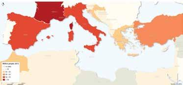
The Mediterranean is the world’s leading tourism destination in terms of both international and domestic tourism with more than 300 million international tourist arrivals representing 30% of total world tourists for 2014. International tourist arrivals have grown from 58 million in 1970 to nearly 314 million in 2014, with a forecast of 500 million by 2030. About 50% of these arrivals are in coastal areas.
One of the main problems is tourist seasonality, given that it is calculated that between the months of June and September the Mediterranean basin receives around forty-five million national tourists and more than fifty million foreign tourists, mainly concentrated on the coast and the islands.
SAN PIETRO ISLAND
Measuring 51 square kilometres, the little-known San Pietro Island is in fact the sixth biggest of Italy’s many islands.
Most of today’s six thousand inhabitants live in the island’s only town, Carloforte. The lively town centre is filled with brightly-coloured buildings where restaurants and a good number of shops and cafes exist.
Province: South Sardinia
Region: Sardinia
Population: 6,151
Size: 51 km²
Arrival port: Carloforte
Journey time from Sardinian mainland: 40 minutes (Portovesme)
Distance from nearest Sardinian mainland port: 12 km
Arrive by: Ferry
Arrive from: Portovesme, Calasetta (Sant’Antioco) Best airport option: Cagliari Elmas Airport (83 km)

Site Photos (Island Trekking Routes)


01 / SEASONAL SWITCH OF SPACES DESCRIPTION OF THE STUDY AREA
International Tourism Receipts, 2015 (Source UN-WTO)
SAN PIETRO ISLAND trekking routes
Cala Mezzaluna - scenic spot
Scenic spot
Faro di Capo Sandolo Scenic spot
Carloforte - meeting point
Capo Sandolo


name: Mykonos size: 86 km² tourism/GDP: 80% name: Syros size: 84 km² tourism/GDP: 48% name: Aegina size: 83 km² tourism/GDP: 18% name: Formentera size: 83 km² tourism/GDP: 75% name: Santorini size: 76 km² tourism/GDP: 90% name: Gozo size: 67 km² tourism/GDP: 76% name: Skiathos size: 50 km² tourism/GDP: 60% name: Lipari size: 37 km² tourism/GDP: 60% name: Bozcaada size: 36 km² tourism/GDP: 48% name: Folegandros size: 32 km² tourism/GDP: 25% The industrial structure of these islands is mostly based on tourism A small number of undeveloped islands are dominated by fishing and agriculture Tourism GDP share chart Project Brief Legend of mapping As the epidemic eases, tourism figures are gradually rising. The Mediterranean is in the spotlight as a global tourism hotspot. At the same time, there are obvious problems: SEASONALITY :traffic is more frequent only in summer; secondary houses are vacant except in summer; people's income is overly dependent on tourism in summer). 0 100 200 500 KM N Similar size islands Ferry terminals Isola di San Pietro Protection area of VME EBSA (Ecological and Biological Significant Marine Areas) National park Density of vessels tracks Sensitive sea area Ramsar site SPA&SAC (EU Habitats and Birds directive) name: San Pietro size: 51 km² tourism/GDP: 39% Mediterranean tourists flow map Americas 17,200,000 Africa 5,100,000 Middle East 19,200,000 Asia and the Pacific 15,100,000 Europe 243,600,000 01 / SEASONAL SWITCH OF SPACES CRITICAL MAPPING MEDITERRANEAN


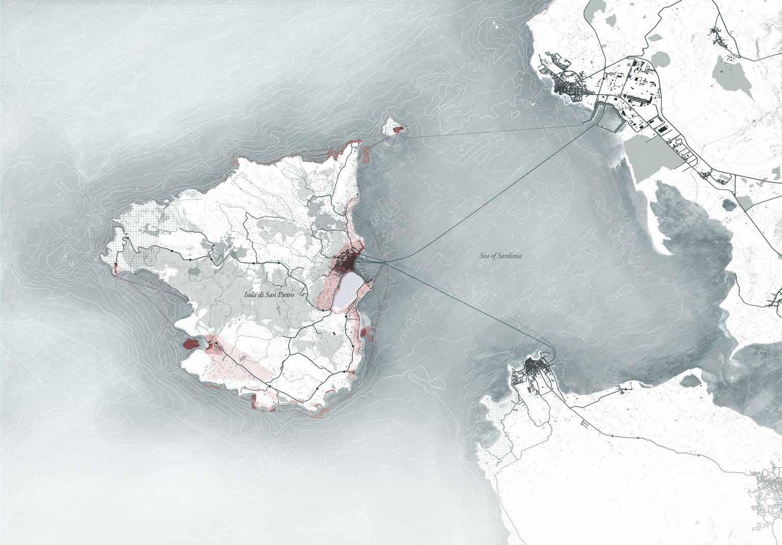

0 1 2 5 KM N Spiaggia Giunco Bricco Bubbò Bricco delle Lille Bricco del Polpo Spiaggia di Dietro ai Forni Spiaggia di Girin Spiaggia Punta Nera Spiaggia Guidi Spiaggia di Sottotorre Spiaggia La Salina Spiaggia Grande Spiaggia La Bobba Punta delle Colonne Le Colonne Cala dei Busselli Scogliera del Bue marino Cala Mezzaluna Belvedere Capo Sandalo Punta dei Cannoni Punta Capodolio Spiaggia Punta S'Aliga Punta Trettu Punta Trettu Scogliera Cianassee Spiaggia sulle rocce rosse Croce sul promontorio roccioso del paese Capo Altano Capo Giordano Scogliera della Punta delle Oche Bricco Guardia dei mori Belvedere della Cala Lunga Sentiero Verde Fortino della Mezzaluna Saline di Carloforte Mercatino Rionale Spiaggia Lûcaise Spiaggia di Portopaglietto Caletta di Geniò Spiaggia delle Chinelle Spiaggia della Conca Spiaggia La Caletta Spiaggia Cala Fico Cala Vinagra Nuraghe Tanche Piscine naturali Nasca Cala Lunga Spiaggia Tacca Rossa Spiaggia Cantagallina Spiaggia di Canalfondo Spiaggia della Punta Grotte della mezzaluna Faro di Capo Sandalo TonnaraIsola Piana Tonnara di Calasetta .legend Coastal tourism Inner land tourism Historical/ Cultural tourism Spots density Activities Pressure Land use and infrastructures View points sea caves dense winery boat tour medium birdwatching cliff diving low rocks camping sup tour snorkeling scuba diving windsurf sandy beach Shrub Wood Salt pond Sandy beach Main roads Bus stops Trekking routes boat route Buildings ports Carloforte Carloforte-PortoVesme Calasetta-Carloforte Calasetta Portoscuso Jan. May. Sep. Mar. Jul. Nov. Feb. Jun. Oct. Apr. Aug. Dec. Activities Festivals & Events Hotel32 B&B -132 Car rental -3 Parking lot -5 Hotel 19 B&B -67 Parking lot -6 Hotel 35 B&B -150 Car rental -1 Parking lot -1 01 / SEASONAL SWITCH OF SPACES CRITICAL MAPPING SAN PIETRO ISLAND


01 / SEASONAL SWITCH OF SPACES CRITICAL MAPPING SAN PIETRO ISLAND 30 m 0 sea level Service Activity house wooden area village sandy beach (high pressure tourism area) wooden area 30 m 0 sea level Service Activity wooden area house wooden area 60 m 90 m 120 m 150 m rocky beach 30 m 0 sea level sea area wooden area house wooden area open green area houses wooden area sandy beach (high pressure tourism area) wooden area open green area wooden area sea area Service Activity 30 m 0 sea level Service Activity sea area wooden area village wooden area house 60 m 90 m 120 m 150 m wooden area sea 30 m 0 sea level Service Activity wooden area open green area wooden area 60 m 90 m 120 m 150 m rocky beach 180 m house open green area +160m s.l.m +0.00m s.l.m +149m s.l.m +0.00m s.l.m +107m s.l.m +0.00m s.l.m +47m s.l.m +0.00m s.l.m +0.00m s.l.m +0.00m s.l.m Cala Fico 1:3000 Faro e belvedere di Capo Sandalo 1:3000 Spiaggia La Caletta 1:3000 Saline di Carloforte 1:3000 Le colonne di Carloforte Spiaggia La Bobba 1:3000 Cala Vinagra 1:3000 Spiaggia della Punta (1.555) Spiaggia di Tacca Rossa (156) Spiaggia di Cantagallina (269) Carloforte port (530) Saline di Carloforte (144) Spiaggia Giunco (307) Spiaggia Girin (307) Spiaggia Punta Nera (620) Spiaggia Guidi (797) Spiaggia La Bobba (809) Colonne di Carloforte (881) Tonnara Isola Piana (205) 2 5 A A' LANDSCAPE DESIGN STUDIO 2_2022-2023_Prof. Garofalo Francesco, Prof. Geroldi Chiara_ with TA. Konstantinos Venis, Ludovica Barcucci, Enrica Brusa Group 7: Dasco Alice 10585850, Kelesoglu Sena 10832411, Liu Xinyue 10823464, Shen Tianyu 10834874 Section 3 1:3000 Faro e belvedere di Capo Sandalo Section A-A' 1:13500 Section 1 1:3000 Le colonne di CarloforteSpiaggia La Bobba Section 2 1:3000 Spiaggia La Caletta Section 4 1:3000 Cala fico Section 5 1:3000 Cala vinagra 1 3 4 Tourism and Seasonality Conceptual Section
STRATEGICAL APPROACH: SAN PIETRO ISLAND

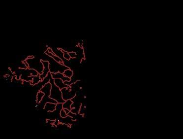
The main strategy is to build mobility network to experience the landscape and explore the points of interest till the dead ends (B) connectors (C) identity and promoting a sustainable tourism that gradually gets rid of cars and private boats. Arriving from the main land the welcome area is Carloforte waterfront (A).



PROJECT
DESIGN:
PRINCIPLES
Current situation B B B 1 2 A C C C Design B B B 1 2 A C C C
A B1 B2 B3
Stunning view points from cliffs, natural reserve habitat
Carloforte-PortoVesme
Excavation area Natural reserve Ex-Saline -public Boat access -private Bus stop Trekking-existing Trekking-proposal Secondary road Boat parking -private Boat parking -public Settlement Places of interest A B1 B2 B3 Carloforte-PortoVesme Calasetta-Carloforte .legend Land use Route System Attraction points Dense vegetation Excavation area Natural reserve Ex-Saline Main road bike lanes Boat access -public Boat access -private Bus stop Trekking-existing Trekking-proposal Secondary road Boat parking -private Boat parking -public Settlement Seasonal site Places of interest Boat routes Land use (including dead ends 'B') Route system (the main connectors 'C') Attraction points (including dead ends 'B')
Calasetta-Carloforte
Characters of Island
STRATEGICAL APPROACH: CARLOFORTE
Main aim is to enhance Carloforte waterfront to tap into the potential sites, turning seasonality into flexibility while expanding the public area to serve both locals and visitors alike.


Off season: Locals open space use Current situation


On season: Tourists open space use Flexible open space use
1. INSULAR ACCESIBILITY
Managment of the access and parking of boats (public and private) on the island's waterfront.

2. CONNECTOR Join the urban settlement to the rest of the Island to promote the soft mobility to explore the Landscape.

3. OPEN SPACES NETWORK
Boost and strenght the open spaces system providing a new vibrant waterfront and restore the relationship between city and sea.

4. GREEN SCAPE
Introduce the Macchia Mediterranea vegetation in the waterfront of the urban settlement, which is a main character of the Island identity.

01 / SEASONAL SWITCH OF SPACES DESIGN: PROJECT PRINCIPLES
P P P P P P Piazza Repubblica Town Hall Touristic Harbour Ferry Touristic Harbour Retail Harbour Fishermen Harbour Natural Park Punta du Din ON OFF Piazza Pegli Piazza San Pietro Apostolo Saline Torre San Vittorio museum Punta Spalmatoreddu Fitness Park Piazza Angelo Aste School gardens Communal gardens Current Open Spaces Restored Open Spaces Seasonal Spaces Logistic Spaces Bike Lane Bus Route Open Spaces network
Design
MASTERPLAN: CARLOFORTE WATERFRONT (1:2500)

01 / SEASONAL SWITCH OF SPACES DESIGN: PROJECT PRINCIPLES

PLANT SELECTION 01 / SEASONAL SWITCH OF SPACES DESIGN: PROJECT PRINCIPLES
SECTIONS
SITE PLAN 1: WATERFRONT (1:500)

01 / SEASONAL SWITCH OF SPACES DESIGN: PROJECT PRINCIPLES

SITE PLAN 2: [PLAYGROUND] PARKING LOT (1:500)
01 / SEASONAL SWITCH OF SPACES DESIGN: PROJECT PRINCIPLES
PASSING ON THE MEMORY
encompassing connections, links, events, and stories that cross the ‘boundary’ between spaces and memories, and offering opportunities for a more holistic understanding of space.
Vignale, Italy
2022
group project in collaboration with: Clara Peters| Yuanyuan Tang | Xinyue Liu | Xinyu Zhao | Yilin Sun

02.


130 320 Elevation Landslide(Quiescent) Landslide(Active) Landslide Slope
Vignale Monferrato
Section
Vignale Monferrato
Vignale Monferrato 320M
Camagna Monferrato
A A-A' A’ 320 M 250 M 260 M 270 M 280 M 290 M 300 M 310 M Scale 1:10.000 1km 0 0.5 0.75 0.25 0.1 Building Road Contout Line Flowline Landslide(Quiescent) Contoni Landslide(Active) Flood Area Mostly Clay Mostly Sandstone Route of the UNESCO site Monferrato degli infernot Legend 02 / PASSING ON THE MEMORY THEMATIC ANALYSIS TERRITORIAL SCALE
Cascina Mongetto
Formation process of the Cantoni


Analysis of village activities

Analysis of pavement materials


Analysis of drainage system


Wastewater Treatment Winery 320m Church of Saint Barto lomew Castle of Vignale Parking Parking Vineyard Church of San Sebastiano Oreste Buzio 310m 300m 290m 280m 270m 260m 250m 240m 230m Bar/Restaurant Field/Vineyard Open spaces(private) Open spaces(public) Mostly Sandstone Mostly Clay Green space permeable Sewerage Network Water flow Drainage facilities Horizontal drainage ditch Drainage ditch on one side of the road Drainage wells Legend Permeable Impermeable Green Stone Sand mixed gravel Concrete Stonebrick Legend 245 265 279 283 290 302 300 293 279 264 273 258 240 252 254 261 264 272 275 272 278 281 210 252 273 272 276 279 284
Properties of the Cantoni Distribution of Pietra da Cantoni in the village Pietra da Cantoni used in iconic buildings Easily cut The ocean fades and the marine sediments fold, forming hills. Its history begins about 20 million years ago with a submarine origin and is a cement marl. Constant temperature Non-corrosive Contains biological fossils Church of Saint Bartholomew Vinery Oreste Buzio Palazzo Callori Enoteca Regionale del Monferrato il Monferrato Degli Infernot Sferisterio Cesare Pozzi Parking Lot Parking Lot Parking Lot Parking Lot il Casa Serpentello Parco della rimembranza Chiesa della Beata Vergine Addolorata Contains plant fossils Pietra da Cantoni used in residential buildings
da Cantoni used in wall
Pietra
Legend Tamburello (sept-aug) Traditional sports activit Monferrato classica (jun-sept) Classical music to promote the monferrato area Vignale monferrato festival (jun-jul) Tradition of contemporary dance Patronal festivities (aug) Celebration of San Lorenzo adn San Bartolomeo Vignale in danza (jun-jul) Performance by international young dancers Festival dei vini (oct) Tradition of wine cultivation 0 100m 50m 20m 0 Buildings Roads Slope Pietra da Cantoni used in residential buildings Pietra da Cantoni used in walls Pietra da Cantoni used in iconic buildings Pietra da Cantoni and Infernot Historic Walls Route of the UNESCO site Monferrato degli infernot Legend Scale 1:2000 200m 100 50 0 Festival /Activities venue 24mm 87mm 39mm 81mm Jan Feb Mar Apr May Jun Jul Aug Sep Oct Nov Dec 0mm 50mm 100mm 150mm 200mm Precipitation analysis January May 02 / PASSING ON THE MEMORY THEMATIC
Pietra da Cantoni and Infernot
ANALYSIS URBAN SCALE


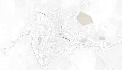


1: 2000 Church of Saint Bartholomew Vinery Oreste Buzio Palazzo Callori Enoteca Regionale del Monferrato il Monferrato Degli Infernot Sferisterio Cesare Pozzi Parking Lot Parking Lot Parking Lot Parking Lot Casa Serpentello Parco della rimembranza Chiesa della Beata Vergine Addolorata Existing Regional+UNESCO's Touristic Itineraries Proposed system Legend Infernot Hills Bike Monferrato Degli Infernot Hiking Route Existing landuse Forest Orchard Historical walls Other walls in the proposed system Other walls outside the proposed system Building 0 200M SECTION A-A' A A' 0 10 M 4. Porta Urbica 5. Casa del Serpentello 1. Il Castello 6. Chiesa del Convento 3. Palazzo Callori 2. Chiesa di San Bartolomeo Abandoned winery Existing stone pavement Adding pedestrian pavement Monferrato degli infernot hiking route Panaromic view Change to stone pavement Existing heritage Legend Strategy framwork + new interpretation of cantoni + re-organize open spaces for festivities + connect open spaces 10 50 15 + + + 20 24 1 ---14 ---20 + + + 3 + 3 100 30 60 Legend Existing Parking Area Parking Capacity New Street Parking Strategy for parking system Strategy for route system brick wall road road road road road road road + car parking public open space public open space private open space private open space private open space private open space Piazza Italia Piazza Callori Il Monferrato Degli Infernot Piazza Callori wire netting historic wall cantoni historic wall cantoni historic wall cantoni Church of Saint Bartholomew concrete wall brick wall concrete wall 02 / PASSING ON THE MEMORY DESIGN STRATEGY MASTERPLAN
Scale


1 2 3 4 5 6 7 Area 1 Area 2 Area 3 Area 4 Area 4 Vignale monferrato festival Vignale in danza Patronal festivities Vignale in danza Vignale in danza Vignale monferrato festival Festival dei vini Vignale monferrato festival Tamburello Vignale monferrato festival Vignale monferrato festival Festival dei vini Church of Saint Bartholomew Tower Palazzo Callori Enoteca Regionale del Monferrato Scale 1:500 50 m 0 25 10 Legend Distribution of Pietra da Cantoni in the village Drainage analysis Other analysis Pietra da Cantoni used in residential buildings Pietra da Cantoni used in iconic buildings Central green space Activity space Parking lot Pietra da Cantoni and Infernot Historic wall Residential building Sewerage Network Water flow Horizontal drainage ditch Drainage ditch on one side of the road Drainage wells Pietra da Cantoni used in walls 8 9 Entrance 1 2 3 4 5 6 7 8 9 02 / PASSING ON THE MEMORY
STRATEGY SITE-SPECIFIC ANALYSIS
DESIGN


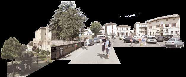
02 / PASSING ON THE MEMORY DESIGN STRATEGY SITE-SPECIFIC ANALYSIS Car parking Car parking Public open space Public open space Pedestrian slope Car parking Cantoni Wall Palazzo
Palazzo Caroli 9 m Church
A B C C' B' A'
Caroli
of Saint
Bartholomew
Spatial incoherence
B-B'
C-C' Scale 1:500 Scale 1:500 Analysis for shadow User analysis Daily Use Events Use Hours Summer Winter Hours
Section
Section


The 9m height difference reduces the accessibility of the two open spaces.

Coherence
9m Functions
Coherence Before After Functions
Reorganize the topography, break the 9-meter height difference, and design a coherent step to connect the two open spaces.


The central square was occupied by parking spaces and in front of the Palazzo Callori had only a simple path and lawns,with very few activities.


New square with a big tree as main view which also create shadow for people to gather. And the long new stairs link the center square with the new open theater in front of piazza callori, together with multifunctional stage and lawn for tourists and residents.
Drainage
When it rains, the water flowing down from high places will transport some dirty soil.

Drainage
Two drainage ditches are designed to purify rainwater. The central square is designed some permeable pavement, while continuous space makes rainwater flow better to the green space below.
02 / PASSING ON THE MEMORY DESIGN STRATEGY SITE-SPECIFIC APPROACH


“Pietra da Cantoni” Point Function Point Carriageway Main route (pedestrian) Secondary route (pedestrian) Branch route (pedestrian) Disabled access Parking space Green space “Pietra da Cantoni” area Bazaar & Square Stage area Green space activity area Theatre steps Temporary stairs Legend Water system Route system 02 / PASSING ON THE MEMORY DESIGN STRATEGY OVERALL SITE DESIGN Gravel open ditch Mist spray pipe Impermeable pavement Green space Rainwater purification Permeable pavement (gravel) Legend Scale 1:500 Scale 1:500 Section A-A1 Section B-B1 1. Pavement 2. Retaining Walls 3. Seating Light yellow granite with texts Use the same color as Pietra da Cantoni Pietra da Cantoni Pietra da Cantoni Weathering Steel Surface engraving 1200 420 1650 150
Reuse of Pietra da Cantoni
For the vegetation, there is a system applied with leading trees, secondary trees and perennial plants as the ground layer. This way the plants create diversity in different layers in the space. Also has been looked at diversity through the seasons, so every time of the year the trees will decorate this place.


Sunlight Hours Analysis: The daylight exposure is significantly improved by the design, with a maximum of just orange and a few areas with a purple colour due to plant shading (slight sunlight hours). The shading of the central area provides shade and landmark for people to take part in events. The slope on the east side of the Grand Staircase with the planting acts as a good air oxygen bar and provides convenience for the users. Here the time of year is set to summer, and a graph of the heat generated


02 / PASSING ON THE MEMORY DESIGN STRATEGY
Quercus rubra Platanus acerifolia Magnolia grandiflora Acer saccharum Ulmus parvifolia Sorbus aria 20 20 19 13 9 13 8 Max Height Span Width Name Meter 10 LEADING TREES Quercus rubra Platanus acerifolia Magnolia grandiflora Acer saccharum Ulmus parvifolia Sorbus aria 20 19 13 13 8 Max Height Span 10 Quercus rubra Acer saccharum Platanus acerifolia LEADING TREES Height:15-21m Height:10-20m Height:12-20m Flower: Spring Flower: Spring Ulmus parvifolia Sorbus aria Magnolia grandiflora L. SECONDARY TREES Height:12-20m Height:8-12m Flower: Aut./Sum. Height:10-18m Ulmus parvifolia Sorbus aria Magnolia grandiflora L. SECONDARY TREES Height:12-20m Height:8-12m Flower: Aut./Sum. Height:10-18m PERENNIAL PLANTS|Ground layer Amsonia hubrichtii Perovskia“little spire” Carex flacca Stipa giganta Molinia caerulea Height:60 cm Height:30 cm Height:15 cm Height:80cm Height:90cm Platanus acerifolia Magnolia grandiflora 19 Platanus acerifolia Height:12-20m Ulmus parvifolia Sorbus aria Magnolia grandiflora L. SECONDARY TREES Height:12-20m Height:8-12m Flower: Aut./Sum. Height:10-18m PERENNIAL PLANTS|Ground layer Amsonia hubrichtii Perovskia“little spire” Carex flacca Stipa giganta Molinia caerulea Height:60 cm Height:30 cm Height:15 cm Height:80cm Height:90cm Existing trees Add the leading tree GREEN PUBLIC SPACE SQUARE OPEN THEATER Garden The central square is sunny, seats and a deciduous tree Quercus rubra are designed. The leaves will turn red to attract the eye in autumn, which can be used as a symbol of the central square. Plant Acer saccharum at the entrance, which blooms in spring and turns red in autumn. Can be used as one of the signs.
shaded
the staircase is planted with moisture and cold tolerant shrubs. Ulmus parvifolia is planted on the steps. Flowering in autumn is one of the characteristics and can be used as a symbol. The garden part provides outdoor privacy for people. So higher grass-Molinia caerulea was planted to block the view. Also the leaves of Acer saccharum turn red in autumn as a sign.
PLANTING STRATEGY Plant selection Plant-shadow effect leading trees
The
part of
is preserved, and
added
and flowering will become one of
The monument tree in the site
the newly
tree with changing leaf color
the landscape symbols.
superimposing all hours
by
of sunlight

1 main square 1 2 3 5 6 7 8 9 10 11 D 4 2 parking lot 3 benches 6 stairs with benches 7 path ( 5% slope 5 lawn with herbs and trees 8 open theater 9 multifunctional stage 10 multifunctional lawn 11 garden blow up A 4 entrance of park B C 02 / PASSING ON THE MEMORY DESIGN STRATEGY SITE PLAN
Axonometric drawings Daily


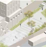

Axonometric drawings Events


02 / PASSING ON THE MEMORY DESIGN STRATEGY MULTIFUNCTIONALITY OF SPACES
Section B-B1 B B1 Scale 1:200 Section A-A1 A A1 0 15 30m Entrance 2 Garden Multifunctional lawn Multifunctional Open theater Platform Grass slope Entrance 1 0 15 30m Entrance 2 Multifunctional lawn Multifunctional stage Grass Stairs Entrance 1 Event/Activity Space Pietra da Cantoni wall Blow up-A Blow up-B Blow up-C Blow up-D
RESILIENCE THROUGH CLIMATE-RESPONSIVE DESIGN
a system to tolerate impacts of drivers like natural hazards without irreversible change in suburban settlements
Chittagong, Bangladesh

2021 03. individual project

ABOUT THE CITY & PROJECT SITE
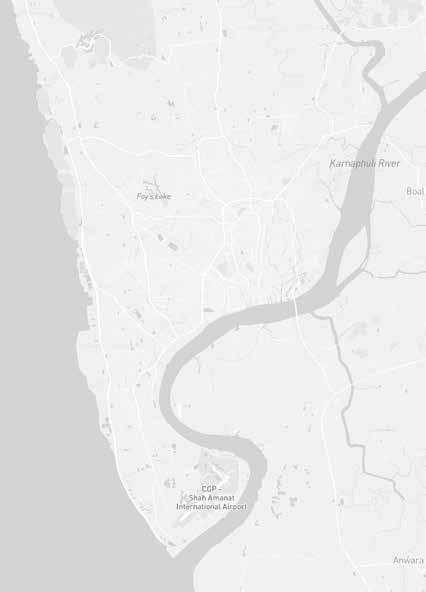

Chittagong is a city shaped by natural obstacles, especially the monsoon climate. This project is about how to strengthen resilience through a climate-responsive design in suburban settlements by exploring local, especially climate-related problems.
The project area as a suburban area is Laliarhat Neighborhood of Chittagong. Slum settlements have been built on the areas which are near the wetlands, along the main road-side, and narrow alleys are vulnerable to natural disasters because of the methods and materials they are made of.
In monsoon seasons, they suffer from water percolation. The findings provide evidence for the need for a climate-responsive design, especially in suburban areas, in order to ensure resilience at both the neighborhood and the urban scale.


 Climate/Rainfall
Location- Chittagong, Bangladesh
Climate/Wind Ecosystem Services Green Spaces Open Spaces Closed Land Use 03/ CLIMATE RESPONSIVE DESIGN DESCRIPTION OF THE STUDY AREA
Project Site
Site Analysis
BUILDING TYPOLOGIES


Low
Quality
Analysis
quality in methods and materials of their making
quality with damage caused by environmental influences and not being taken care Medium quality in methods and materials of their making
Low
03/ CLIMATE RESPONSIVE DESIGN DESCRIPTION OF THE STUDY AREA mid-rise Material: Brick Mostly they have store. There is no relationship with steet because doors open mostly to the garden side. Material: Brick Generally they have garage.Doors open to the street side. Direct relationship with street. Material: Concrete They have two entrance. One of them for the street side,the other one for the garden side. Direct relationship with street. Material: Brick and tile There is only one entrance for the street side which creates direct relationship with street. Material: Brick and tile Generally they have two storey but sometimes there is a hidden storey. Direct relationship with street. Material:Concrete No direct relationship with street. Built on a multi-step earthen platform. Material: Brick and tile Mostly one entrance and direct relationship with street. Material:Concrete They have 3-4 stairs. Doors of the apartment opens mostly to the street side which creates relationship between street. Material:Concrete They have at least 5 stairs. Doors open to the street side and direct relationship with the street. Material:Wood and Bamboo No relationship with street. Walls constructed with lightweight materials. Material:Natural Plants No relationship with street. Good performance in terms of cross ventilation. The service units are seperated. TYPE PHOTOGRAPH GROUND FLOOR ELEVATION DESCRIPTION small detached shop one entrance small detached shop two entrance courtyard cluster slum row house one storey mid-rise apartment low-rise mid-rise stilt house machan house 1 2 3
CLIMATE RESPONSIVE DESIGN
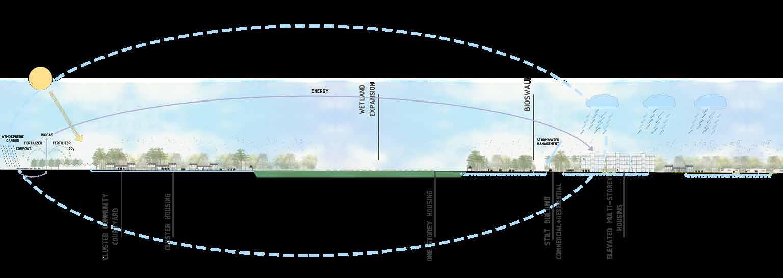
The concept is about nature-based solutions such as green roofs, green facades, green space and wooded areas as innovative and promising ways to increase climate resilience and make cities more pleasant and healthier places to live. It is a system to tolerate impacts of drivers like natural hazards without irreversible change

Resilience against the impacts
Introduction of low impact building material and construction technology
Development of standardized and labor friendly pre-fabricated mode of construction using minimum/ economic building elements
Addressing contextual issues climate responsive design approach

03/ CLIMATE RESPONSIVE DESIGN EXPLANATION OF THE CONCEPT
DESIGN OBJECTIVES
COMPACT THE CITY
everyone is able to access basic physical and social services on an equal footing, such as affordable serviced housing, accommodation, clean water and sanitation, healthy and adequate food, waste management, transport, education and culture.
GRIDAL NETWORKING
prioritizes improved synergies among every day uses, as well as facilitating the economic and social balance by ensuring accessibility to affordable housing options, enhancing safety and security, promoting social interaction and ensuring access to highquality basic facilities and public spaces.
GREEN PUBLIC AREAS
with high-quality connections to green, integrated and cost-effective roads, sidewalks and parks
WETLANDS
provide a wide variety of culture and cultural activity spaces for community engagement. Disasters and climate changes, such as floods, drought and heat waves, need to be adaptive. Water efficiency and sustainable utilization through water rehabilitation
TRADE AND LOCAL MARKETS
run in well-built streets and other safe, open, green, high quality public space networks, which can be accessed by everyone and which allow the optimum commercial usage of the main street floors. This supports the use of open fields and promotes walking.


03/ CLIMATE RESPONSIVE DESIGN EXPLANATION OF THE CONCEPT
Connections
Green & Blue Built environment
Conceptual Plan
Legend Main connections One storey housing Sub connections Multistorey housing Tree alignment Wetland expansion Community gathering space Greenery Drain connection
HOUSING TYPOLOGIES

The overall design accounts for designing connections to propose a more compact urban form with the water interaction. Around expanded wetland, there is a riparian zone and eco-walk opportunity for a need of interaction with nature as well as people. This offers an interaction between green, blue, and human.
Bridges and elevated pathways connected with other areas provide access to transition by experiencing such interaction while supporting the resilience with ecologically friendly expand and branching.
Green areas on the roadside between commercial buildings have a potential to function as a community market place to offer the products produced in agricultural areas for sale and thus to ensure an efficient cycle in terms of both production and consumption while improving social interaction.
The most important consideration is reflecting the identity of Chittagong by merging cultural and natural attributes into resilience design with treatment of storm water quality through ecological solutions and canopies with diversity of tree species. Therefore, creating a quality spaces for community engagement gain importance to strengthen resilience with such consideration.
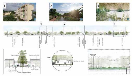


03/ CLIMATE RESPONSIVE DESIGN DESIGN DETAILS SITE PLAN
Site Plan in 1:200 scale
Site Plan in 1:500 scale
Street Furnitures
OVERALL VIEW
courtyard housing artificial ponds
market place public corporation wet meadow
school agriculture mosque elevated multistorey housing

03/ CLIMATE RESPONSIVE DESIGN DESIGN DETAILS
mangrove swamps courtyard housing
temple one storey housing
pocket park main wetland
NETWORK OF GREEN PATCHES
that conserves values and functions of nature, and provides associated benefits to urban life 2020
Gölbaşı, Ankara, Turkiye
individual project

04.

ABOUT THE CITY & PROJECT SITE

As the first step of the term project, analysis were conducted through 4 major titles which are People, Interaction, Environment, Development with 4 groups. After examining the PIED analysis presentations, synthesis work was carried out on problems and potentials which would affect the design through the concept of Lanscape Matrix. A synthesis considering the establishment of a system in the city was conducted under 5 different scales that will affect this system gradually:
1. General settlement of Gölbaşı around the main roads which are one of the major components of an urban
2. Medium-sized open spaces which are important at the area level to see how these areas lead social, cultural, and environmental conditions
3. Smaller local public spaces and target points including Pocket & Neighborhood Parks as a crucial component of the physical and aesthetic quality of urban neighborhood
4. Corridors and Connection networks of Gölbaşı for pedestrians and cyclists including Creek Sides, Bridges, and Sidewalks which are the most basic elements of a city.


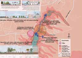


04 / NETWORK OF GREEN PATCHES DESCRIPTION OF THE STUDY AREA
Settlement of Gölbaşı Protection Areas
Corridors and Connections Settlement of Gölbaşı
Cultural & Environmental Conditions
Gölbaşı
Project Site
Site Analysis
DESIGN OBJECTIVES
Creating a system of public spaces which are large or important green spaces which are Greenbelt & Urban Forest around Potential Wetland (in the town scale);
Strengthening and connecting medium-sized green spaces which are important at the area level: Mogan Park, Atatürk Sahil Park, City Park, Mevlana Park, Stadium by making them more sustainable with some touches and developing networks with sustainable solutions;
Using smaller local green spaces and target points which are Pocket Parks & Neighborhood Parks as stepping Stones, connectors and transition to other patches;
Rehabilitating/creating connection networks for pedestrians and cyclists along Creek Sides, Bridges, and Sidewalks to bring strong integration in the urban life; and Effective use of planting, the most basic elements of green, for the connections out in the landscape which are outside the Building Zone Greenery.
These would work as the tools to gain the identification of several open spaces in different levels of sizes, wellbeing everyday-life, the connected town, and accessibility to green spaces.
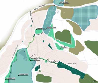


Proposal Patch-Matrix-Corridor


Overall Network System of Patches
The industrial part near to Ankara Highway: to show the general approach towards its existing situation. It is possible to say that area is very problematic in terms of both environmental and spatial conditions. The idea is to design the area as an urban forest which will be integrated into the woodland in the east side of this area. Urban forest would offer various opportunities such as air purification, green effect, protection from pollution, recreational activities like cycling, walking, etc. Forest will be connected with green corridors to other patches of the city. This corridor also will create a buffer effect between the area and forest.

Current Patch-Matrix-Corridor Analysis Current Proposal

04 / NETWORK OF GREEN PATCHES EXPLANATION OF THE CONCEPT
MASTERPLAN (1:1000)

Project site covers the industrial part, wetland, steppe area, and afforested area a wide range of essential ecosystem services to meet in the city is one of the main aims, which is the main aspect of an urban forest. In this urban forest, generally, vegetation formation of METU Forest and Plant Species Adapted to Ankara Climate will be preferred as a collection of trees.


04 / NETWORK OF GREEN PATCHES DESIGN PROPOSAL
Exploded layers
design site
Bridge as connector
Green corridor as a connector and open space
MAIN CONNECTORS OF THE PATCH NETWORK
MASTERPLAN


04 / NETWORK OF GREEN PATCHES DESIGN PROPOSAL
Floating island plants 1:1000 Masterplan
Steppe garden plants
(1:1000)
CONE/FRUIT RIPENING PERIODS & SEED COLLECTION TIMES FOR MANAGEMENT OF THE FOREST

04 / NETWORK OF GREEN PATCHES DESIGN DETAILS
SITE PLAN (1:500)


Design components for interaction with nature
04 / NETWORK OF GREEN PATCHES DESIGN DETAILS
Along the green corridor to the lake
SITE PLAN (1:200)

04 / NETWORK OF GREEN PATCHES DESIGN DETAILS
OVERALL VIEW OF SHELTER CAMPUS
cafes/restaurants
institute library ateliers
walking, cycling/ recreation area
children playground
conservation center square
ateliers nature conservation main building car parking green hills car parking
shelter campus main building
isolation units
sky-lighted units
wooden deck

glass transport tunnel pathway and sitting area with pergola
buffer zone community display housing with courtyard
04 / NETWORK OF GREEN PATCHES DESIGN DETAILS
MOOD GARDEN: ‘EXCITED’
the sense of sight and touch making excited with these various characteristics of both plants own and as a composition 2020
Ankara, Turkiye
individual project

05.

MOOD: EXCITED
“A sense of place is the soul of a garden. It is the intangible and harmonious atmosphere that stems from a perfect balance between the house, garden, landscape, plants and importantly, the dreams of the owner/user… The quality of light, the sound of the wind, the texture of the plants and the smell of the earth, leaves and flowers all add to its unique atmosphere”
(Maynard, 2004:7).


05 / MOOD GARDEN: ‘EXCITED’ MY MOOD! MY GARDEN!
Site Photos
Wooden platfrom in front of the door
Backyard
Wooden decorative element Garage door in the backyard
Backyard door from the villa Passageway
MOOD: EXCITED
FRONT GARDEN
a sense of attracting with different textures varied according to all seasons with different parts of plants


BACK GARDEN
the variety of textures, colors and light and shadow effect on plants and pool with the permeable pergola
monotonous color for harmony in summer light and shadow on various colors, and texture in a composition variety of colors of dıferent features of plants according to seaons


05 / MOOD GARDEN: ‘EXCITED’ MY MOOD! MY GARDEN!
Pool
Overall view of backyard
Lawn area shaded
Wooden element and surrounding
Overall view of frontyard
Variety of different species
Combinations to avoid monotony
Dense planting and relaxing area
Plant selection
sena.keles.sena@gmail.com selected works
2020-2023


 Climate/Rainfall
Location- Chittagong, Bangladesh


