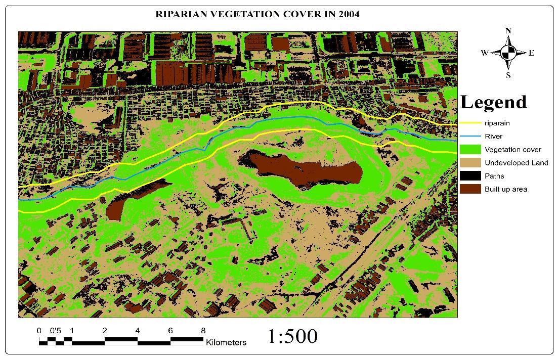
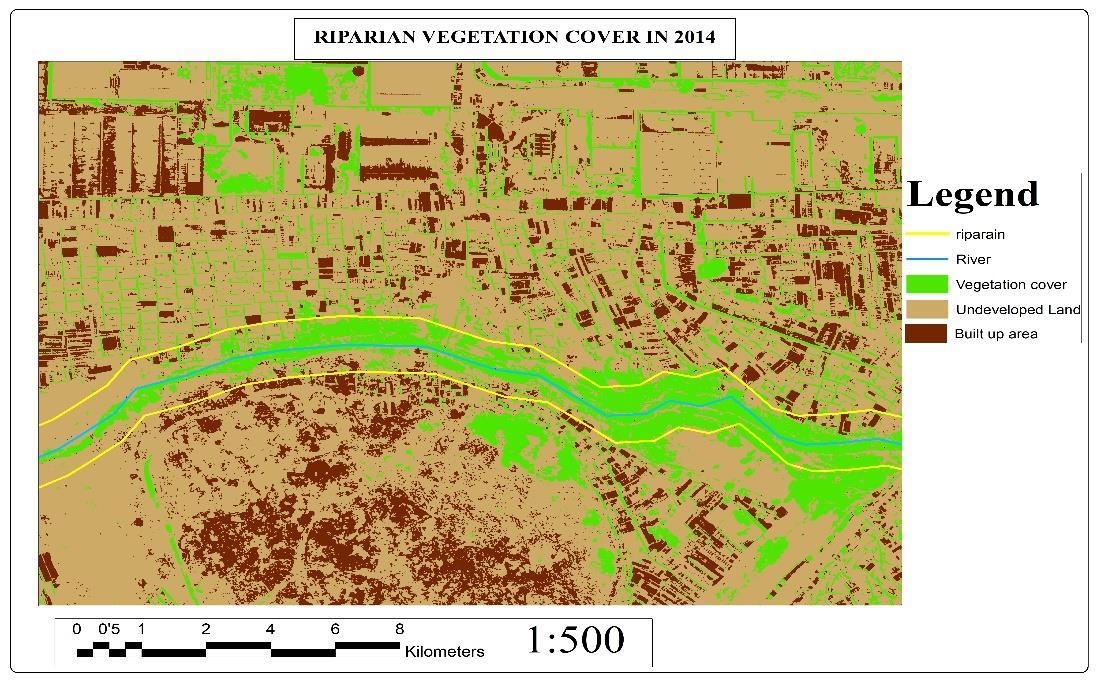
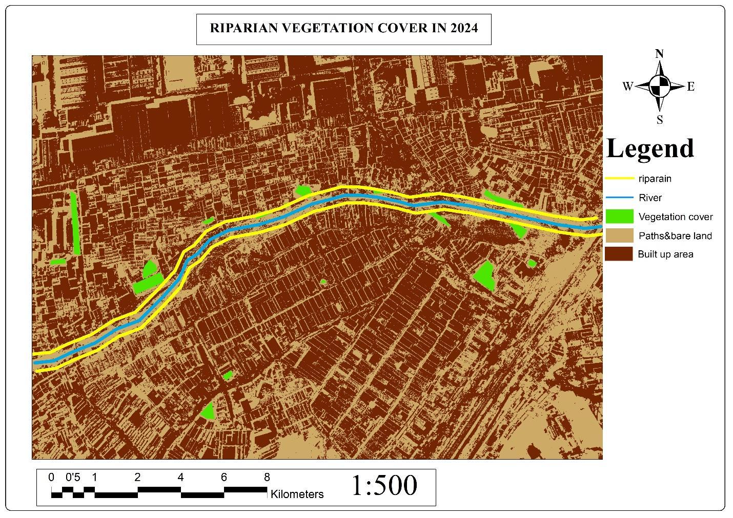
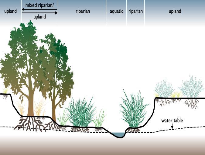
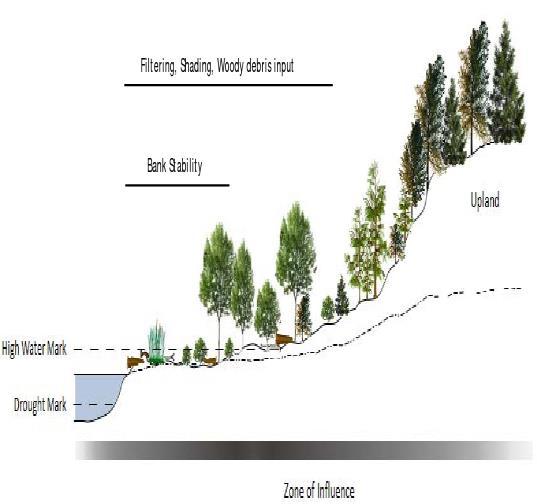
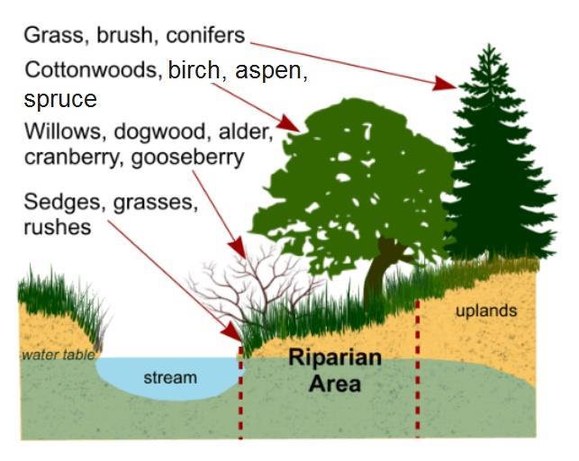
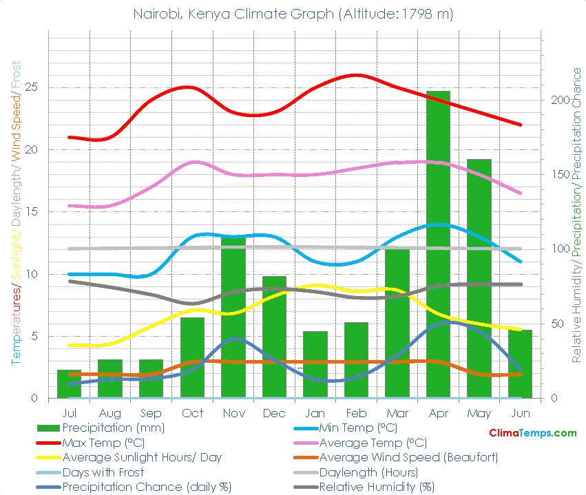
NAIROBI RIVERS’ REGENERATION DESIGN STUDIO COMPETITION IN KENYA.
(KWA REUBEN SEGMENT 2)
AUTHOR: SHARLENE MAINA
ABS 211-0244/2020
Submitted in partial fulfillment of the requirements for the degree of Bachelor of Architectural Studies at:
JOMO KENYATTA UNIVERSITY OF AGRICULTURE AND TECHNOLOGY
SCHOOL OF ARCHITECTURE AND BUILDING SCIENCES
DEPARTMENT OF ARCHITECTURE September, 2024.
INTRODUCTION
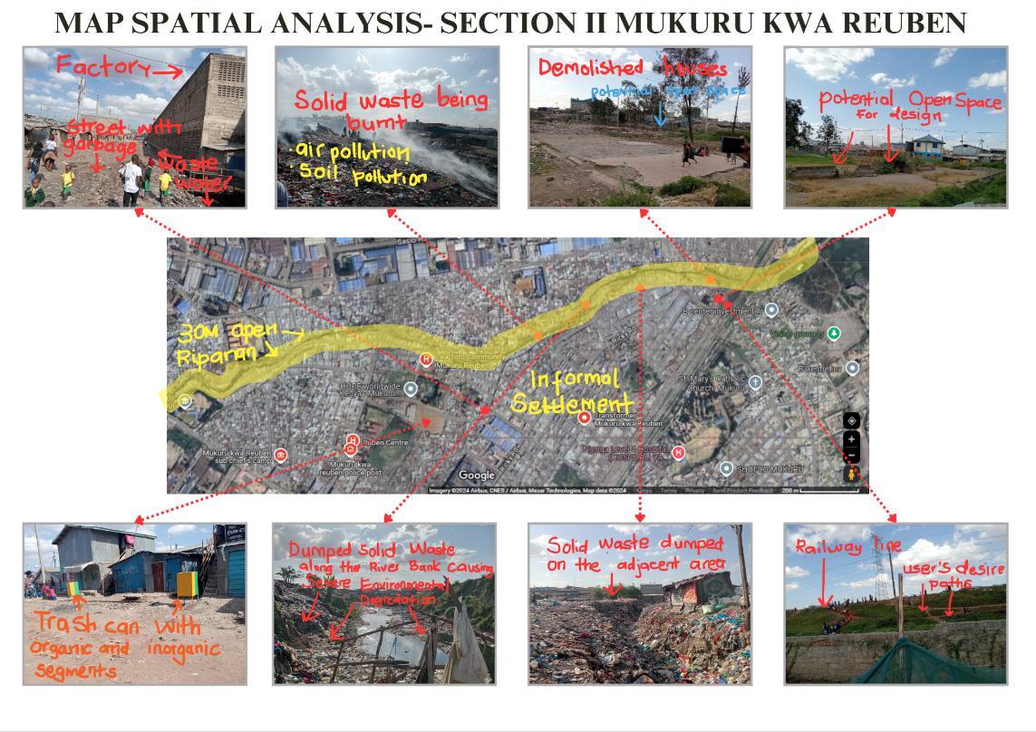
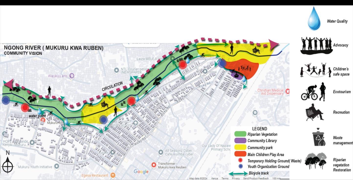
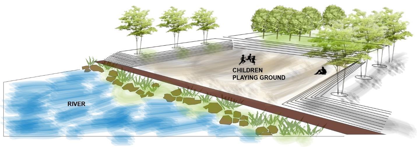
The assignment of the project is to develop an innovative community- led River’s riparian design, that enhances climate resilience and improved quality of life through Nature Based solutions and Green Gray Infrastructure approaches. This will focus on Ngong’ River riparian zone, along Mukuru kwa Reuben Segment 2 settlement. Kwa Reuben segment 2 is in Mukuru kwa Reuben settlement, its neighborhood being Viwandani, Kwa Njenga and segment 1. Along it is River Ngong, which has a 30m riparian, consisting of a temporary children playground, a temporary waste holding ground and also parts vulnerable to floods as seen below. Under this segment, there is the need of proper and sustainable solutions and safe spaces for the community.

LITERATURE REVIEW
Introduction

River ecosystems play a critical role in sustaining our planet by providing essential services that contribute to human well-being and health. However, they are among the most threatened ecosystems worldwide, with freshwater species facing extinction at alarming rates compared to those in oceans or on land. Climate change exacerbates these threats, leading to more frequent floods and droughts, while rapid urbanization poses significant challenges such as pollution, habitat destruction, loss of biodiversity, disruption of hydrological cycles and water scarcity (Siddha et al., 2022).
Urbanization and population growth in Kenya have resulted in changes in land use, leading to river ecosystem degradation (Odenyo et al.,2017). Nairobi City is an example of urban development that has caused intense loss of vegetation cover and increased coverage of built-up areas for business, industries, road networks and residential structures. The city has subjected Ngong’ River to waste pollution and assimilation until the river has turned into a sewer-like system with a foul smell (Njogu et al.,2011). Biodiversity is lost due to rapid urbanization and encroachment of riparian zones.
Ngong’ River
Ngong River is an essential water body located in Nairobi County and forms part of the upper catchment of Athi River basin. It originates from Motoine Swamp to Dagoretti Forest and then flows through the Dagoretti area, Ngong Forest and ends at Njiru where it joins Nairobi River, which is a tributary of the Athi River. The river basin’s length is about 42.3 km, while the total catchment area from the source to where it forms a confluence with the Nairobi River in Njiru is about 127 km2 The basin comprises four different sections; the upstream section of Nairobi Dam, Nairobi Dam itself, a dam outlet, as well as the section from the dam outlet to Njiru where it forms a confluence with the Nairobi River. Ngong River flows within the Nairobi City’s boundary at a distance of about 28 km, of which 10 km are within the industrial area. The river also passes through various informal settlements such as Kibera and Mukuru slums (Kithiia, 2007, Musyoki et al.,2015). Meanwhile, Ngong River drains an area characterized by high population growth coupled with the mushrooming of informal settlements, particularly the Kibera and Mukuru slums. The river traverses Kenya’s capital city and industrial hub, making it vulnerable to water pollution for being used as an urban waste conduit for all the areas it traverses (Kithiia, 2007, Musyoki et al.,2015). There has been an expansion of human settlements and industries along Ngong River over the past decade, the area lacks basic sewerage infrastructure systems and most pollutants are discharged directly into the river. The river faces numerous challenges like increased storm water run-off and erosion, altered geomorphology and topography, increased pollution, climate change, biodiversity loss among others.
LEGAL AND POLICY FRAMEWORKS

Source: Land and Water: Resolving The tension of climate change and urbanization in Nairobi

Globally, river management is guided by frameworks like the UN Watercourses Convention (1997), which promotes the equitable use and protection of transboundary watercourses. The Ramsar Convention (1971) focuses on the conservation of wetlands, including river ecosystems, emphasizing their sustainable use. The Sustainable Development Goals (SDG 6) also advocate for clean water and sustainable management of water resources, including rivers, at all levels. At the international level, Integrated Water Resources Management (IWRM), endorsed by the Global Water Partnership, encourages coordinated management of water, land and related resources to maximize social and environmental welfare. The European Union’s Water Framework Directive (2000) is a notable example, aiming to protect water bodies by maintaining ecological balance and water quality.
Locally, in Kenya, the Water Act (2016) and the Environmental Management and Coordination Act (EMCA, 1999) govern the protection and sustainable use of water resources, including rivers. The National Environment Management Authority (NEMA) enforces riparian zone regulations to protect river ecosystems from pollution and encroachment. Additionally, the National Water Resources Management Strategy sets guidelines for the management and conservation of rivers at both national and county levels. In Nairobi County, river management is influenced by both national and county-level policies. The Nairobi City County Environmental Management Act (2015), mandates the protection of water resources, including the rivers flowing through the county, such as the Ngong’ River. This Act focuses on preventing pollution, ensuring proper waste management, and restoring riparian areas. The Nairobi Rivers Basin Rehabilitation and Restoration Program together with Ngong’ River regeneration groups are key initiatives aimed at revitalizing rivers like Ngong. These programs seek to address issues like pollution, encroachment and degradation through collaborative efforts between NEMA, the Nairobi City Water and Sewerage Company and local communities. The program aligns with the Kenya Water Towers Agency’s to protect river catchments and water sources, ensuring sustainable urban water management and ecological restoration in Nairobi.
METHODOLOGY
This includes the type and sources of data, research approach, research setting, research methods, data collection and presentation and ethics.
i. Data needs
The following parameters were collected from primary and secondary sources
PARAMETERS METHODSOFDATA COLLECTION
RESEARCH
TECHNIQUES
Water quality Primary observation
Riparian zone Primary
Observation (transect walk) and group discussions
Flood prone areas Primary and secondary Focus Group discussions and annotated maps
River riparian zone utilization Primary
Conservation measures put in place Primary
Waste management Primary
Drainage and storm water Primary and secondary
Vegetation cover Primary and secondary
Community Aspiration primary
ii. Research approach
Focus Group discussion
Observation (transect walk), group discussion
Focus Group discussion and observation
Focus Group discussion, and observation
Observation and photography
Focus Group discussion
This study adopted a descriptive approach to answer questions validly and objectively. Descriptive approach is suitable since, it seeks to describe the characteristics of variables. Such as the environmental status describing the water, waste management, soil and vegetation of Ngong river ecosystem.
iii. Research setting
This study was carried out in a natural setting, an environment that was not subjected to any manipulation. This research was carried out along Ngong river ecosystem, Mukuru kwa Reuben.
iv. Research methods
This study was conducted systematically using both qualitative and quantitative research methods to collect information as per the objectives.
v. Data collection methods
The research study employed both qualitative and quantitative methods to gather data. Secondary data was collected through literature review, journal articles, books, government documents, research theses, and other relevant sources from the internet. The study employed focus group discussion, observation and site visits to Ngong River and the adjacent landscape as primary data collection method.
vi. Data recording methods
Data collected from primary and secondary methods were recorded through note taking, drawing, sketching, photographs and annotated diagrams.
vii. Sampling
An accessible population to represent the larger group (target population) was selected, to estimate the utilization of the river corridor and the environmental quality effects to the entire population.
viii. Data presentation
Analyzed data was presented in graphs, pie charts, tables and reports. The images captured during observation were well captioned and presented.
ix. Research ethics
Respondents consent was sought whether to participate in data collection or not.
Respondents were assured confidentiality of the information.
The respondent’s identities remained anonymous.
Permission was asked from the relevant authorities before data collection was done.
Population and demographics
The “Mukuru Belt” of informal settlements consists of Mukuru Kayaba, Mukuru kwa Njenga, Mukuru kwa Reuben, and Viwandani. Mukuru Kwa Reuben is part of the larger Mukuru informal settlement in Nairobi, one of the most densely populated areas in the city. According to 2019 census, sixty percent of the inhabitants earn <10,000 shillings per month, or less per day inconsistently. Some live on 0.50 cents per person in a household per day and live on <½ a dollar per person per day (Save the Children, 2003). The poorest earn <5,000 shillings per month, about $USD33/month (World Bank, 2022).
Population Size

Mukuru Kwa Reuben is home to tens of thousands of residents. It is estimated that the Mukuru area (which includes Kwa Reuben, Kwa Njenga, and Viwandani) houses over 300,000 people. Kwa Reuben alone is estimated to have a population ranging from 50,000 to 100,000, but precise numbers are often hard to pin down due to the informal nature of the settlement.
Gender Breakdown
Like many urban informal settlements, Mukuru Kwa Reuben has a fairly balanced gender distribution. Women typically make up around 50-55% of the population. Many women are heads of households, particularly in singleparent families. Men account for about 45-50% of the population. Many men work in nearby industries or as casual laborers.
Age Distribution

The population in Mukuru Kwa Reuben is predominantly young, with a large percentage being children and youth under the age of 30. Many families have several children, contributing to the youthful demographic profile. The settlement is home to a mix of both working-age adults and school-going children. Most households in Mukuru Kwa Reuben are small and compact, often consisting of single-room structures. The average household size tends to range between 4 to 6 people, with extended families sometimes living together due to the high cost of living in Nairobi.
Gender and social inclusion
Mukuru Kwa Rueben, faces complex socio-economic challenges affecting gender social inclusion. Both girls and boys in this community experience unique barriers due to poverty, cultural norms and limited access to services. This analysis highlights the issues affecting both genders and provides recommendations for fostering inclusion. The population faces a deficit on basic amenities. Women and girls bear the responsibility of managing household water and sanitation, often facing significant challenges due to inadequate water, sanitation and hygiene services. Men and boys also endure similar health risks from unsanitary environments but often receive less attention regarding their hygiene and health needs. While there is some focus on reproductive health for women and girls, adolescent boys face a lack of targeted health programs, especially concerning mental health and emotional support. Boys are often overlooked in community health interventions, and few services address their unique health concerns. Girls and women in Mukuru Kwa Rueben are more vulnerable to GBV due to unsafe living conditions, poor infrastructure and societal norms. Lack of safe spaces for women further increases their risk. Boys face different forms of violence, including gang violence, peer pressure and physical abuse. The absence of positive male role models often leaves boys vulnerable to criminal recruitment and other risky behaviors, affecting their long-term development. Despite free primary education policies, girls often face barriers such as economic hardships, domestic responsibilities and early marriages or pregnancies. Many are forced to drop out before completing their studies, which perpetuates the cycle of poverty. Women and girls are underrepresented in local leadership and decision-making roles. They often have little influence on community development projects or resource allocation and their participation in political processes is minimal. Many of the slum dwellers in Mukuru work as casual laborers in the manufacturing industries situated close to the slum. Others operate small-scale businesses selling vegetables and fruit or hawking various items. Earnings are low and often inadequate to feed their families. Consequently, their children look to other means of survival such as prostitution, drug peddling, begging and other criminal activities. Both males and females work in small businesses and waste sorting and segregation. From the site it was evident that most women do the sorting and segregation of waste along the riparian zones of Ngong River.


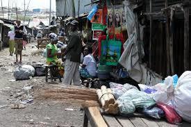
Socio-economic analysis
The riparian offers various benefits to the community. It offers llivelihood Support because urban agriculture in the riparian provide food and income. Altering the riparian reduces water quality and Supply for the Settlement making it hard for the community to access water services. Pollution from urban runoff and waste increases health risks and costs of health care services, posing more expenses to the community. There is often occurrence of floods in Kwa Reuben Settlement caused by heavy rains but exacerbated by human encroachment to the riparian. This leads to frequent property loss, and economic burdens. The floods also lead to soil erosion, which leads to damages of infrastructure. Therefore, a restored riparian zone could improve quality of life.
Community Engagement
• Community involvement in riparian management fosters ownership and sustainable practices.
• Educational opportunities also promote conservation and sustainable water management.
Challenges faced by the community
The Kwa Reuben settlement experiences several challenges, primarily floods and waste management. To start with, the area is vulnerable to flood risks caused by clogged drainage systems and the absence of drainage in some parts, where the community has occupied spaces designated for drainage. These floods result in the displacement of the community, the spread of diseases, and the destruction of infrastructure. Therefore, there is a need for sustainable flood management solutions to mitigate and adapt to the floods. Secondly, the area is experiencing poor waste management, both solid and liquid. This is primarily caused by uncontrolled dumping due to a lack of proper holding sites for solid waste and the absence of sewer systems for liquid waste. Most people in the settlement direct their sewage into the Ngong River, leading to its degradation. This is further exacerbated by sewage from industries containing dangerous chemicals. This call out for the need of permanent waste management infrastructure, to curb this challenge.
Coping mechanisms
Raising the ground with soil to avoid high effects of the soil.
Wearing gumboots during rainy season.
Formation of community-based organizations e.g. Mukuru Oasis CBO for garbage collection.
Youth in the settlement use black soldier fly in waste management.
Land use analysis
MukuruKwaReubenisadenselypopulatedinformal settlement located along the Ngong River in Nairobi, Kenya. The area has a mix of land uses, includingresidential,industrial,commercial, and public spaces.
Residential
Most of the land in Mukuru Kwa Reuben is used for housing. The homes are mostly informal structures made from materials like iron sheets and wood. The high population has led to overcrowding, with many families living in small, shared spaces. Industrial and Commercial Areas
The settlement is close to several industrial zones. Many residents work in nearby factories or run small businesses within the settlement. These businesses range from small shops to informal markets where people sell food, clothes, and other goods.
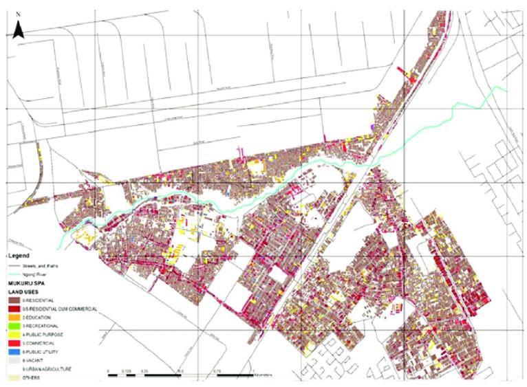
Source: Slum Dwellers International
Public and Social Amenities
The area has limited public services, such as schools, health centers, and community centers. Most of these facilities are underdeveloped, and there is a lack of proper infrastructure such as clean water, sanitation, and waste management.
Informalownership
Most residents of Mukuru Kwa Reuben do not have formal ownership of the land they live on. The settlement has grown without official government planning or legal land distribution. As a result, many people occupy land without proper title deeds or legal recognition of ownership. Even though the land is largely informal, many residents pay rent to local landlords. These landlords often do not have legal rights to the land but have built structures and rent them out to low-income families. This creates a complicated system where residents are vulnerable to eviction, despite paying rent. Some of the land is owned by industries located nearby. Because the settlement isonlandearmarked for industrial or publicuse,formalizinglandtenure has been difficult, leaving many residents without legal claims.
Efforts Toward Formalization
In recent years, there have been efforts by the Kenyan government and organizations to improve land tenure security for Mukuru residents. Programs aimed at upgrading slums and providing residents with proper documentation have been discussed. These efforts are crucial for improving housing conditions and ensuring long-term security for the people living there.
PHYSICAL INFARSTRUCTURE
Access
Mukuru kwa Reuben is characterized by unplanned road access which navigate through the settlement up to the riparian zone. Li settlement, it is primarily served by a few main roads that act as the primary arteries for movement in the area.


Direct, secure and clear access roads to the riparian zone are limited and often encroached upon by informal housing and structures. This limits the ability to develop clear, safe pathways to the river for residents These main roads are often narrow, polluted and congested, pedestrians. From the main roads, a network of smaller secondary roads extends into the interior of the settlement. These smaller roads unpaved, narrow, lacking drainage and winding. They serve as the primary means for residents to access their homes, the river, local community facilities. Many of these roads are in poor condition, with no drainage infrastructure, leading to frequent flooding during This affects accessibility and can impede emergency services.
Land Ownership


Access to the riparian Housing
Access to the Riparian Zone
The majority of housing in Mukuru kwa Reuben consists of informal structures made from materials like corrugated metal sheets, wooden planks, and reclaimed materials. These structures are often densely packed, with narrow pathways between them. High-density housing in Mukuru kwa Reuben results in a lack of open spaces. Initially, houses were often built right up to the edge of the riparian zone, sometimes within the area that should be protected as part of the river buffer. Lately, there has been eviction from the riparian zone and therefore the nearest structure to the river in 30 meters away. Houses are arranged in an unplanned manner, with no formal orientation towards the riparian zone or main access roads. This irregular layout results in limited and sometimes hazardous access to the river and the riparian zone.

Access to the riparian zone and the Ngong River is primarily through narrow, informal footpaths that have been created by residents over time. There is no established pathway system that runs along the riverbank, limiting movement and accessibility. These pathways often weave between housing structures and are not planned or maintained. These informal pathways are be difficult and insecure to navigate, especially during rainy seasons or late hours. This makes it challenging for residents to reach the river safely and limits the potential use of the riparian zone for recreational or community activities.
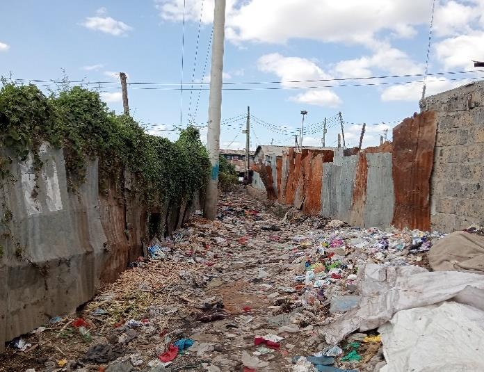
Before demolitions, the riparian zone was encroached upon by housing and other informal structures, resulting in physical barriers that restrict movement along the riverbank. This encroachment disrupts the natural flow of the river and limits access for activities like river clean-up efforts, community gardens, or the creation of recreational spaces. Currently, there are debris, wastes and illegal dumping left out in the riparian area, which are limiting proper utilization of the riparian, blocking its circulation.

Therefore, the few existing main roads that run near the river could serve as potential formal entry points to the riparian zone if they are developed and connected to a well-planned network of pathways and public spaces. There is also an opportunity to create a continuous pathway or green corridor along the riparian zone that would enhance both ecological and human circulation. This could include walking and cycling paths, boardwalks, and viewing platforms that provide safe and accessible movement along the river.
Recommendations for Improved Circulation and Access
Establish Formal Pathways
Create Buffer Zones
Reorganize Housing Layout
Enhance Road Infrastructure
Multi-Functional Riparian Spaces
Water and sanitation
Waste management
Water is a scarce resource in the settlement. The community access water through boreholes, the tap water and rain water. Water from the river is very polluted and therefore unsafe to use. The rain water is only accessible during rainy seasons only where the community harvest the water for different purposes. The boreholes are few and the qualityof water ispoor.Also, the cost of drillingis high and most urban poor people cannot afford. There is illegal connected piped water, Which is not accessible to all. This therefore means that the area is underserved in terms of water provision and there is need for reliable water provision. Sanitation facilities such as latrines and sewer systems are in bad state and absent in some parts of the area. There is need for a quicker intervention for this challenge. Barriers to water access
Unreliability
Long wait
High cost
Long distances
pollution


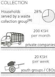
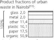
Mukuru Kwa Reuben is part of the larger Mukuru slums, which face numerous challenges such as poor housing, inadequate sanitation and limited access to basic services12. Waste is scattered in various areas of Mukuru Kwa Rueben, posing a significant health and environmental risk to residents. About 28% of households are served by a waste collection group. Households pay 200 KSH per month to private companies. Youth groups or Community-Based Organizations (CBOs) charge 20 KSH per week for waste collection services. The Nairobi City Council provides 10–15 garbage collection trucks, but these services do not reach Mukuru Kwa Rueben, leaving the area dependent on youth groups or private companies, which charge prices few can afford. Organic Waste represents 50.9% of urban waste in Nairobi. Organic materials like food waste, leaves, and biodegradable matter. They are often discarded without proper disposal systems, contributing to pollution and public health risks. There is also recyclable waste like glass (2.0%), metal (2.0%), plastic (16.1%), and paper (17.5%). There is no organized garbage collection system for both liquid and solid waste. Mukuru’s sewage system is in a state of disrepair. Remnants of an old underground sewage network exist but are no longer functional. Instead, an open-air drainage system is in place, collecting liquid waste from temporary dwellings and public toilets. This waste is discharged directly into the nearby river, severely polluting the water and spreading diseases such as cholera (caused by Vibrio cholerae), which has led to numerous deaths. Solid waste dumps are common throughout Mukuru Kwa Rueben, often located on roadsides, near homes, along riverbanks, or in any available empty space. These unregulated dumps significantly harm the environment. Organic waste decomposes, releasing dangerous gases that damage respiratory health, while other materials, such as heavy metals, leach into the soil and water, polluting aquifers. During the dry season, waste piles can catch fire spontaneously, worsening air quality. The stages are illustrated in the diagram below. The diagram underscores the need for a coordinated approach involving various stakeholders, including the city council, community groups, and youth, to address these issues.

Key components
1. Network: this likely represents the interconnectedness of various stakeholders and resources within the community.
2. City council: indicates the role of local government in managing and supporting the settlement.
3. Commitment: reflects the dedication required from all parties involved to improve living conditions.
4. Collaboration: highlights the importance of working together among different groups and organizations.
5. Youth groups: emphasizes the involvement of young people in community development and initiatives.
6. Environmental and socio-economic issues:
7. Food security: illustrated by plants, indicating efforts to ensure that residents have access to sufficient and nutritious food.
8. Pollution: represented by a pile with dark spots, pointing to the challenges of waste management and environmental health.
9. Recycle: shows the importance of recycling initiatives to manage waste and reduce pollution.
Efforts in food security, pollution control, and recycling are crucial for improving the quality of life in the settlement
Waste Management Challenges
Insufficient Public Services.
Private companies are costly, leaving many residents with no option but to dispose of waste unsafely.
Recycling and other environmental measures are rarely supported.
Informal Waste Disposal Practices
Lack of infrastructure for proper waste management leads to hazardous living conditions and increased health risks for the community.
Responsibility and Solutions
The Nairobi City Council has been criticized for not taking full responsibility for the waste management crisis in informal settlements like Mukuru Kwa Rueben. Public services remain insufficient, and recycling is not supported, leading to a continuous build-up of waste. The situation calls for acknowledgment of the severity of the issue and urgent action by both the local authorities and stakeholders.
SWOT ANALYSIS
1. Strengths
Community Engagement
Mukuru Kwa Reuben has a strong community-based organization (CBO) network that can be mobilized for environmental initiatives. An example is the Oasis CBO which is involved in the collection and segregation of house hold waste.
Proximity to Nairobi CBD
The settlement's location near Nairobi's central business district provides opportunities for economic growth and access to resources.
Community Livelihoods
Some residents rely on the river and its surroundings for activities like small-scale agriculture and cleaning purposes. These activities, when sustainably managed, can support local livelihoods.
Potential for Green Spaces
The riparian zone holds potential for the creation of recreational spaces, community gardens, and green buffers that can enhance the local environment and provide community benefits.
2. Weaknesses
Poverty and Limited Resources
The community faces significant poverty and lack of access to basic services, hindering environmental management efforts.
Informal Land Tenure
The informal nature of land ownership in Mukuru Kwa Reuben makes it challenging to implement long-term conservation strategies.
Lack of adequate infrastructure
Inadequate infrastructure, such as sanitation facilities and waste management systems, contributes to pollution and environmental degradation.
Pollution and Waste Management Issues
The river is heavily polluted with domestic waste, industrial effluents, and sewage due to the lack of proper waste management systems. This pollution affects water quality and disrupts the riparian ecosystem, leading to loss of biodiversity.
Encroachment and Settlement Pressure
Informal settlements have encroached on the riparian zone, leading to the destruction of natural vegetation. This encroachment disrupts the river's natural flow and reduces its capacity for flood mitigation and habitat support.
Limited Community Awareness and Involvement
Many residents may lack awareness of the ecological importance of the riparian zone or how their activities impact the environment. This lack of knowledge hinders community-driven conservation and sustainable use of the river.
Weak Regulatory Enforcement
Existing environmental regulations regarding riparian zone protection are often poorly enforced in informal settlements like Mukuru kwa Reuben. This leads to unchecked pollution, illegal dumping, and encroachment.
3. Opportunities
Government Support
There is potential for increased government support for environmental projects, including funding for riparian zone restoration and community-based initiatives.
Partnerships with NGOs
Collaboration with non-governmental organizations can provide technical expertise, financial resources, and advocacy support.
Sustainable Development Initiatives
The riparian zone can be integrated into broader sustainable development plans for the area, promoting economic growth while protecting the environment.
Advanced Community Engagement and Education
Engaging the local community through awareness campaigns and educational programs can promote the sustainable use of the riparian zone. Community-driven initiatives can lead to better waste management practices and environmental stewardship.
Restoration and Regeneration Projects
There is an opportunity to rehabilitate the riparian zone through planting native vegetation, creating buffer zones, and implementing erosion control measures. Such efforts can restore the ecological health of the river and improve the quality of life for residents.
Sustainable Livelihoods and Eco-friendly Businesses
By promoting sustainable practices like urban agriculture, eco-tourism, and recycling initiatives, the community can derive economic benefits while preserving the riparian zone. Eco-friendly businesses can also provide alternative income sources to the residents.
Urban Planning and Policy Advocacy
Collaboration with local authorities and policymakers can help integrate the riparian zone into broader urban planning strategies. Advocating for the enforcement of environmental regulations and the implementation of sustainable urban development policies can mitigate the negative impact of urbanization.
Climate Resilience and Adaptation
Restoring the riparian zone can enhance the area's resilience to climate-related emergencies, such as floods and heatwaves. Green infrastructure solutions like rain gardens and vegetative swales can be integrated into the regeneration efforts to create a climate-adaptive urban environment.
4. Threats
Continued Environmental Degradation
Persistent pollution, encroachment, and unsustainable land use practices threaten the ecological integrity of the riparian zone. If these issues are not addressed, the river may lose its ecological functions and services.
Climate Change
Climate change poses a significant threat to the riparian zone, with potential increases in the frequency and intensity of floods, droughts, and extreme weather events. These changes can exacerbate the existing vulnerabilities of the area.
Rapid Urbanization
The ongoing expansion of informal settlements and urban infrastructure in Mukuru kwa Reuben poses a risk of further encroachment into the riparian zone. Without proper planning and regulation, urbanization could lead to the complete loss of natural habitats.
Health Risks
Pollution of the Ngong River poses serious health risks to the local population, including waterborne diseases and exposure to hazardous chemicals. This situation can lead to public health crises, particularly during floods when contaminated water spreads into residential areas.
Economic Constraints
The economic challenges faced by residents and local authorities can limit the implementation of conservation and regeneration projects. Lack of funding and resources can hinder efforts to improve waste management, provide alternative livelihoods, and restore the riparian ecosystem.
GENDER SOCIAL INCLUSION IN MUKURU KWARUEBEN
Mukuru Kwa Rueben, one of Nairobi’s largest informal settlements, faces complex socio-economicchallenges affecting gender social inclusion. Both girls and boys in this community experience unique barriers due to poverty, cultural norms, and limited access to services. This analysis highlights the issues affecting both genders and provides recommendations for fostering inclusion.
1. Access to Basic Services
Water, Sanitation, and Hygiene (WASH):
Women and girls bear the responsibility of managing household water and sanitation, often facing significant challenges due to inadequate WASH services. Men and boys also endure similar health risksfrom unsanitary environments but often receive less attention regarding their hygiene and health needs.
Healthcare Access:
While there is some focus on reproductive health for women and girls, adolescent boys face a lack of targeted health programs, especially concerning mental health and emotional support. Boys are often overlooked in community health interventions, and few services address their unique health concerns.
2. Economic Participation
Women and Girls:
Women primarily engage in informal economic activities such as selling goods in local markets and doing domestic work. Girls face high dropout rates due to financial constraints or early pregnancies,limiting their future economic opportunities.
Men and Boys:
Young boys are often forced to become providers at an early age, which results in dropping out of school and working in informal jobs like collecting scrap metal. The lack of mentorship programs for boys often leads to feelings of hopelessness, resulting in higher rates of substance abuse and criminalactivity.
3. Safety and Security
Gender-Based Violence (GBV):
Girls and women in Mukuru Kwa Rueben are more vulnerable to GBV due to unsafe living conditions,poor infrastructure, and societal norms. Lack of safe spaces for women further increases their risk.
Boys and Violence:
Boys face different forms of violence, including gang violence, peer pressure, and physical abuse. Theabsence of positive male role models often leaves boys vulnerable to criminal recruitment and otherrisky behaviors, affecting their long-term development.
4. Education and Skills Development
Girls’ Education:
Despite free primary education policies, girls often face barriers such as economic hardships, domesticresponsibilities, and early marriages or pregnancies. Many are forced to drop out before completing their studies, which perpetuates the cycle of poverty.
Boys and Dropout Rates:
Boys in Mukuru Kwa Rueben are also pressured to leave school to help support their families. The lackof vocational training and career guidance often leaves boys with limited options, resulting in them turning to manual labor or informal employment at a young age.
5. Political Participation and Decision-Making
Women’s Representation:
Women and girls are underrepresented in local leadership and decision-making roles. They often havelittle influence on community development projects or resource allocation, and their participation in political processes is minimal.
Boys and Civic Engagement:
Boys and young men are generally absent from leadership discussions in Mukuru Kwa Rueben. Mentorship programs that encourage boys to take on leadership roles and engage in communityactivities are necessary to build the next generation of male leaders.
6. Cultural Norms and Gender Stereotypes
Girls and Cultural Expectations:
Traditional norms push girls into caregiving roles, limiting their personal aspirations and opportunities for economic advancement. Cultural pressure to marry early or focus on family life prevents many girlsfrom pursuing education or employment.
Boys and Hypermasculinity:
Boys are often expected to be emotionally strong and independent, discouraging them from seekingemotional support or engaging in vulnerable conversations. This hypermasculine expectation contributes to substance abuse, aggression, and mental health challenges for young men.
7. Inclusion in Development Projects
Women’s Participation in Projects:
While there are efforts to include gender-sensitive policies in urban development plans, women’s participation in these projects remains minimal. Initiatives often lack the resources or outreach toencourage women to take active roles in community planning and development.
Boys and Development Projects:
The boy child is often overlooked in community development programs. While many initiatives focuson empowering girls, the absence of programs for boys leaves them without guidance, making themmore vulnerable to negative influences.
8. Mentorship and Youth Empowerment Programs for Girls:
There are existing programs focused on sexual health, education, and life skills for girls, but many are underfunded and limited in scope. More extensive resources are needed to help girls thrive in MukuruKwa Rueben.
Mentorship for Boys:
Mentorship programs for boys are crucial to provide guidance and support for navigating life’s challenges. Positive role models who promote emotional intelligence and constructive masculinity areessential to counter the negative influences boys face. Conclusion
Gender social inclusion in Mukuru Kwa Rueben requires a comprehensive approach that addressesthe needs of both boys and girls. While efforts to empower women and girls are crucial, the boy child must also be included in these initiatives to ensure holistic community development. By fostering positive gender norms, expanding education opportunities, and providing mentorship forboth genders, Mukuru Kwa Rueben can achieve greater social cohesion and equality.

Conceptual diagram illustrating various elements and their interconnections within Mukuru Kwa Reuben, an informal settlement in Nairobi, Kenya. Here’s a breakdown of the key components and theirrelevance:
Key Components:
1. NETWORK: This likely represents the interconnectedness of various stakeholders and resourceswithin the community.
2. CITY COUNCIL: Indicates the role of local government in managing and supporting the settlement.
3. COMMITMENT: Reflects the dedication required from all parties involved to improve livingconditions.
4. COLLABORATION: Highlights the importance of working together among different groups andorganizations.
5. YOUTH GROUPS: Emphasizes the involvement of young people in community development andinitiatives.
Environmental and Socio-Economic Issues:
FOOD SECURITY: Illustrated by plants, indicating efforts to ensure that residents have access tosufficient and nutritious food.
POLLUTION: Represented by a pile with dark spots, pointing to the challenges of wastemanagement and environmental health.
RECYCLE: Shows the importance of recycling initiatives to manage waste and reduce pollution.
RELEVANCE TO MUKURU KWA REUBEN:
Mukuru Kwa Reuben is part of the larger Mukuru slums, which face numerous challenges such as poorhousing, inadequate sanitation, and limited access to basic services12. The diagram underscores the need for a coordinated approach involving various stakeholders, including the city council, communitygroups, and youth, to address these issues. Efforts in food security, pollution control, and recycling arecrucial for improving the quality of life in the settlement

