
PORTFOLIO
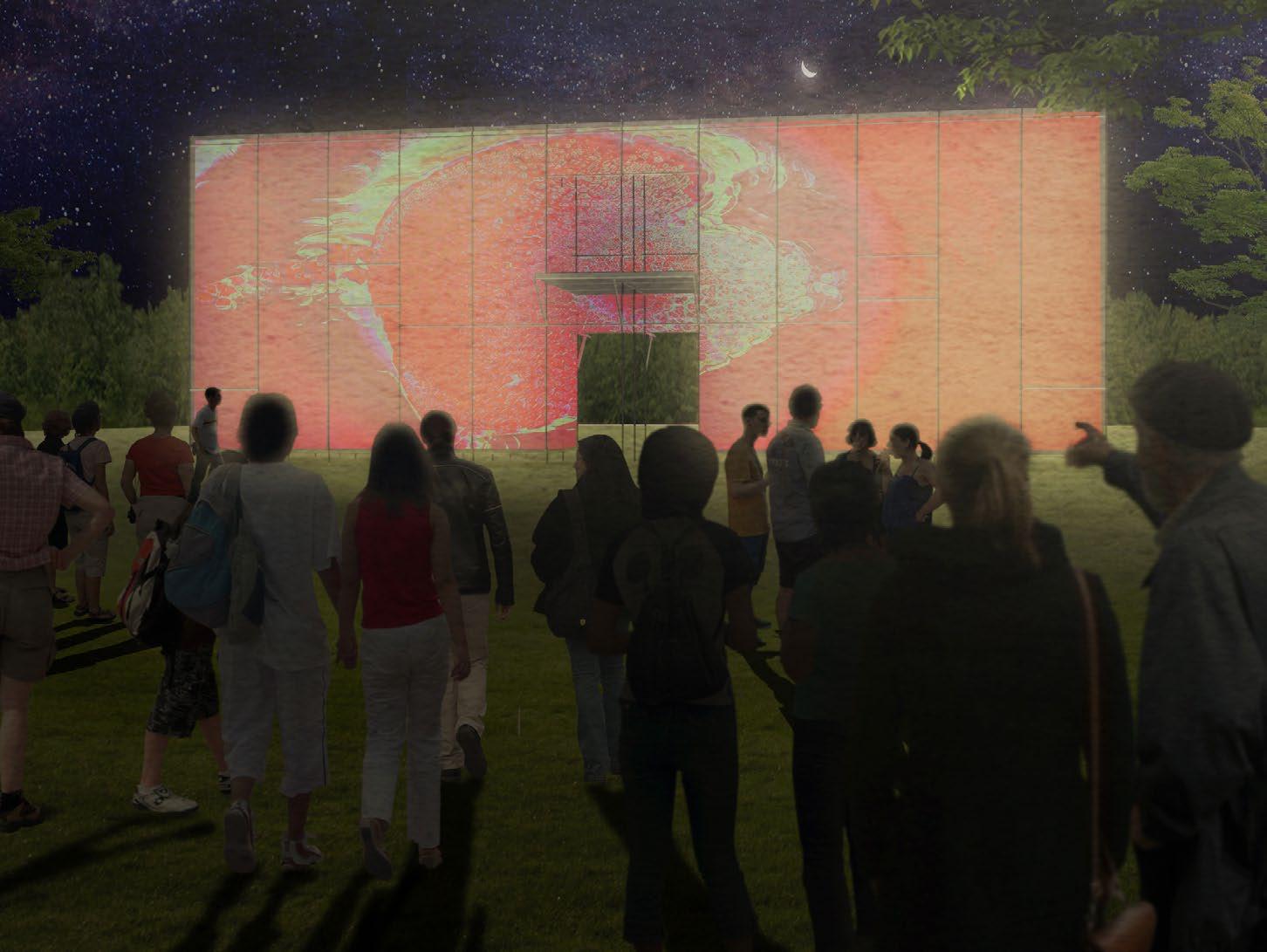
BORDERSURFACE
Outdoor billboards, as a media of information conveying, contain the characteristic of unidirectional reading to viewer. It is also a metaphor of strong theatrical characteristics in form and a pure form of overlapping media images in physical space.
In daily life, spatial patterns are often accompanied by different ideologies, time development, regionalism, and other changes that produce extreme use situations and spatial meanings. However, most people are only familiar with one kind of daily life. I believe that the reality of spatial forms is not a single standard, but based on the spatial implications of multiple levels.
This experimental design attempts to superimpose the spatial experience of images and create different spatial characteristics through the use of a modular fast spatial formation system (eagle frame). Create a bilateral information transfer opportunity to give users a multifaceted experience.
2020.07 - 2020.09Billboard and Window


Both billboard and window are unidirectional communication media for external viewers, while window allows internal space users to obtain external information through transparent media (the glass), thus achieving bilateral information exchange.


By imagining the billboard as a physical and metaphorical �screen�, the screen becomes a medium between the user inside the screen and the external environment and viewer, resulting in new bilateral readability.
Deconstruction of Spatial Characteristics


Deconstruct five daily spatial patterns -- entrance/facade/ arcade/living room/balcony -- and integrate them into this �screen� as part of �performance�.
The scale comparison of each space and the discrepancy between daily form and extreme form are the main goal to differentiate the presentation content of the installation.

Installation
The structure will be constructed by scaffolding system, for its unique feature of modularization, to create five corresponding spaces. These five space types build up this �screen� that gestures the flattening of space perception in daily life and try to make the viewer identify the true colors of the five daily spatial patterns. Finally, via the process of exploring internal and external space of the screen and identifying the most original spatial forms, viewers constantly switched their role between the viewer and the performer to experience multiple realities, the interaction between virtual and real on the screen, the change of cognitive spectrum, and the transition between performance and viewing.


Layer I : Structure
Construct the basic spatial composition.
Layer II : Spatial System

Establish the space inside the system, define space structure by fabric materials and create five space types.


Layer II : External Wrapping
Add the outermost facade, using the translucent material of low chroma as the color mask of the performance and the main presentation layer for projection effect.
Visual Performance
Apply the visual effect to enhance the vary of virtual and reality flowing effect.The fluid particles enhance the lightness of the whole installation, diffusing effect and color change simulate the ripples.


Landscape Architecture

TAIPEI MRT LINEAR PARK
Professional Project
DIRECTOR: Angela.C.soong / Manolo.F.Ufer
ROLE: Design Diagrams / Construction Design / Model Making
Owing to the completion of “ Taipei railway underground project ” , the valuable green space between MRT R11 and R12 station was reserved. From Taipei city-scale perspective, this project could north extent to Taipei EXPO Park , the south extent to West District , and finally complete a valuable, large-scale circle system.
We aimed to improve the accessibility from all directions in this project via two strategies: smoothing the elevation and breaking through all the barriers. People will be more able to pass through this urban green space. Based on the relatively important role as a green space that this site plays in the urban area, we expected to connect the entire ring system of the city via this linear park. To achieve the goal, the green corridor would be extended by linking the tree canopy. Furthermore, we expected this park could not only activate the new lifestyle / relationship in the city but improve the development of the neighborhood.
2016.10 - 2019.12The defining characteristic of freeform is that it holds the promise of a smarter and better “informed” response to the specific problems of a site. Relieved from straight-jacketed Cartesian limitations, loose geometries associated to advanced computation technology make possible a better-tailored, more precise design response to local conditions, This is particularly instrumental when a multiplicity of site constraints need to be addressed.


The elevated city stage is located at the entrance of MRT station for civilians to have the aerial view. This structure is expected to be a new city landmark.
All Canopy
Keeping all the trees in site and moderately replanting trees with the function of bird / butterfly attracting to enrich the green corridor and species diversity.
All Connect
Keeping MRT entrances and ventilation shaft structures, removing unnecessary planters and planting space in order to obtain largest avalable space.
Reinforcing the connection between the linear park and the MRT sunken plaza. Providing social and event space for the neighborhood.
All Terrain
Using simple materials to create a variety of landscapes, platforms, stairs and ramps. Replacing traditional rectangular facilities with streamlined appearance.
All Weather
Modular shelters was placed in the park, providing multi-functional space for users with households that are not affected by the weather.
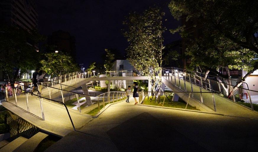
Constellation Play Area-Playground Bridge
Via the elevated terrain, Existing structures could be moderately covered. And the transformation of steps follows the terrain hence could provides resting space for the users. Moreover, the bridge was constructed in between existing trees to provide multi-layered playing experiences.


Final Design Model (1:100)
Made by 3D printing and hand-making. This model was contineously modified during design period and the final version was displayed publicly in construction phase.
Green Corridor
The street furnitures along the street side provide resting chances for pedestrians whenever necessary and offer the extension space for shops and snack bars. At the urban level, the linear park turns into the crucial node of the green connection in Taipei city, which ties the green belt from north to south.
 Urban
Urban
KEELUNG HARBOR MASTRPLAN
2017.12 - Ongoing
Professional Project
DIRECTOR: Angela.C.soong / Manolo.F.Ufer
ROLE: Design Diagrams / Research / Digital Drawing / Model Making
locating at the very north side of Taiwan, Keelung is provided with numerous of advantages to become the main gate for Taiwan to connect with the entire world. With the starting station of railway west coast line and the only cruise-oriented harbor in Taiwan, this city is the first stop and first impression for many foreign tourists when they visit Taiwan.
“0” contains the meaning of “beginning “ , “complete” and “terminal”, we imagine that Keelung Harbor could be the transportation center of surrounding region and the new gate of Taiwan for linking with the world.
Keelung Harbor contains multiple and rigorous constructions. To highlight its strategic significance, we believe that it should continue to enhance land, sea, and air transport functions and services while developing diversified activities to cater to different user groups. The main achievement in this project is the efficient provision of a mobile and functional transport system.

Identity and Attraction
Keelung ’s cultural identity can be concretely demonstrated via the use of space. This project plans the port area by providing a field with local significance to receive tourists and display art and takes this opportunity to reintegrate old and new cultures. The extension of the waterfront creates a space like a water amphitheater, providing special performance space.


Brand New Skyline
The introduction of the architectural structure and landscape design echoes the existing historical buildings and creates a new skyline rhythm.

The Bridge to The Transportation Center
The pedestrian circulation of the city will be separated from the vehicle circulation, and the elevated bridge guides the pedestrians to the transfer station.

Landscape Pattern Echoes the Structure

The landscape pattern follows the design patterns of circulation, the canopy, and the bridge, combining the design style of ground level and elevated level.
 Final Model
Design model with context of Keelung Habor and surrounding area
Final Model
Design model with context of Keelung Habor and surrounding area
NISHI HONGA-JI PLAZA : URBAN BRANCH


2014.04 - 2014.06
Individual Project / Academic
TUTOR: Pei-Ling ,Wu
Location of this project used to be a Japanese Buddhist temple �Nishi Honganji�. This temple was not only a religional building but a temporary columbarium for Japanese soldiers who sacrified in Pacific War . After the war , this place briefly became a detention place for political prisoner after February 28 Incident happened . Today , most of the buildings are no longer exist . People come to this place for taking a rest after shopping in Ximending.
NISHI HONGAN-JI PLAZA is established as an urban plaza for the neighborhood and the tourists in Ximending . By conserving symbolic elements of each history events , this project can once again become a new attractive factor in Ximending that invoking its own unique historical identity .


01.
Keep the existing historical structure, and follow the urban renewal plan(demolishing old residential building).

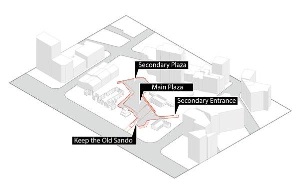

Lower the space surrounded by existing structure for civilian recreational purpose, create wide step as seats.


According
the
A new bridge was placed cross the entire Site to be a new space dominance element, and the bridge could support all space using demand.
Application of Existing Structures - Art and Culture
keep the existing historical guesthouse remains, and insert new wall to enhance the structure and partition space to become an interior exhibition and lecture space; add a second-floor space to improve the capacity of increasing use.
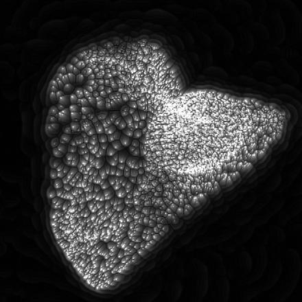
04. Urban Branch(Sidewalk Bridge)... 03. New Intermediary... to surrounding features, divide the ground level space into 5 parts as new buffers. 02. Sunken Plaza ... Keep and Demolished...Reaction Diffusion Simulation

2021.04
Touchdesigner
Video Link
https://vimeo.com/653971260
https://vimeo.com/653972597
Simulate reaction-diffusion effect and ovetlay it with the terrain model to display real-time dynamic effects via Touchdesigner.Color(RGB value) was interpreted as the elevation properties for simulation. The RGB values of each pixel point were assigned as coordinates.


