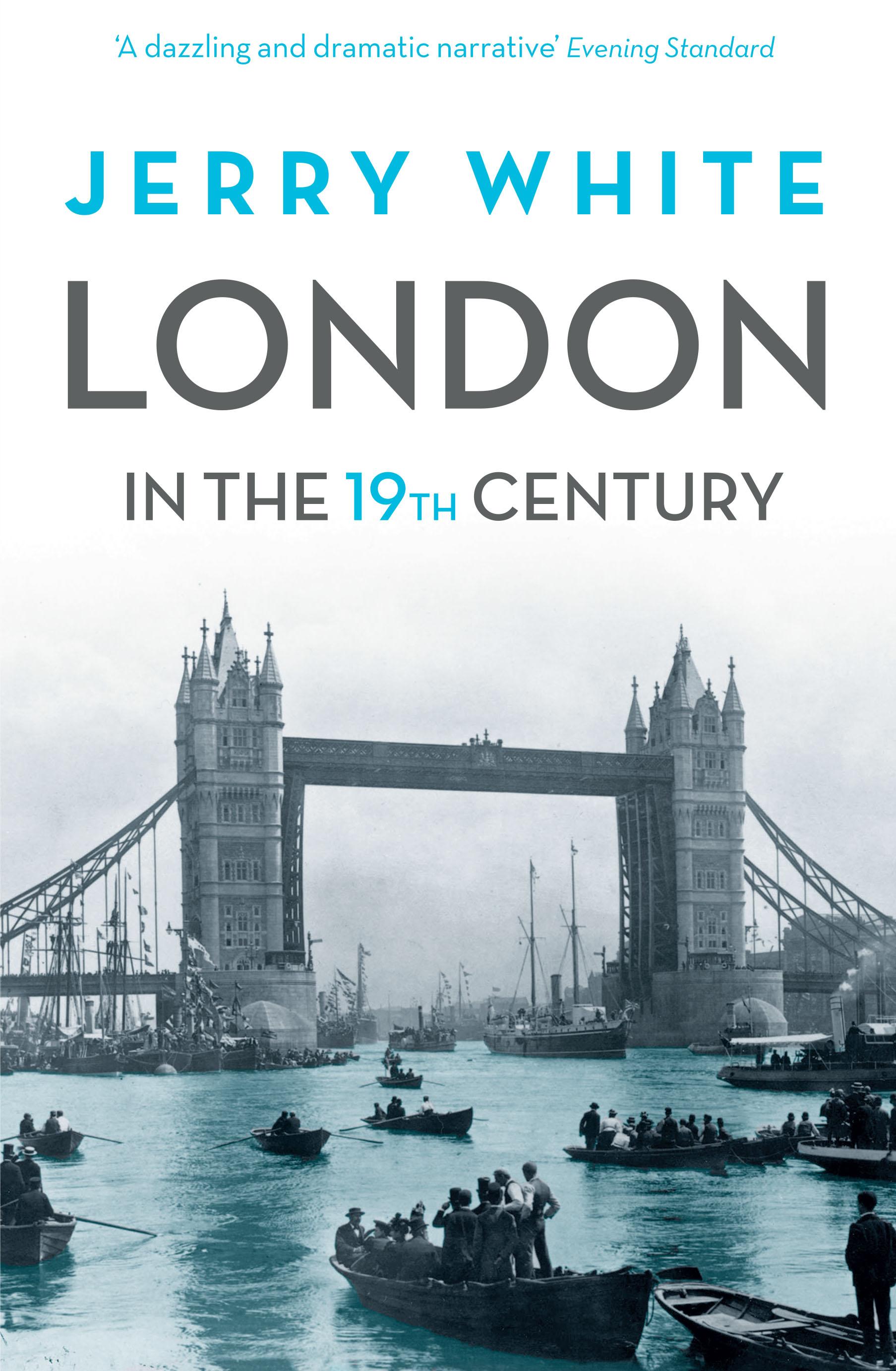
THE MINT: OLD LONDON,
1800 – 1855
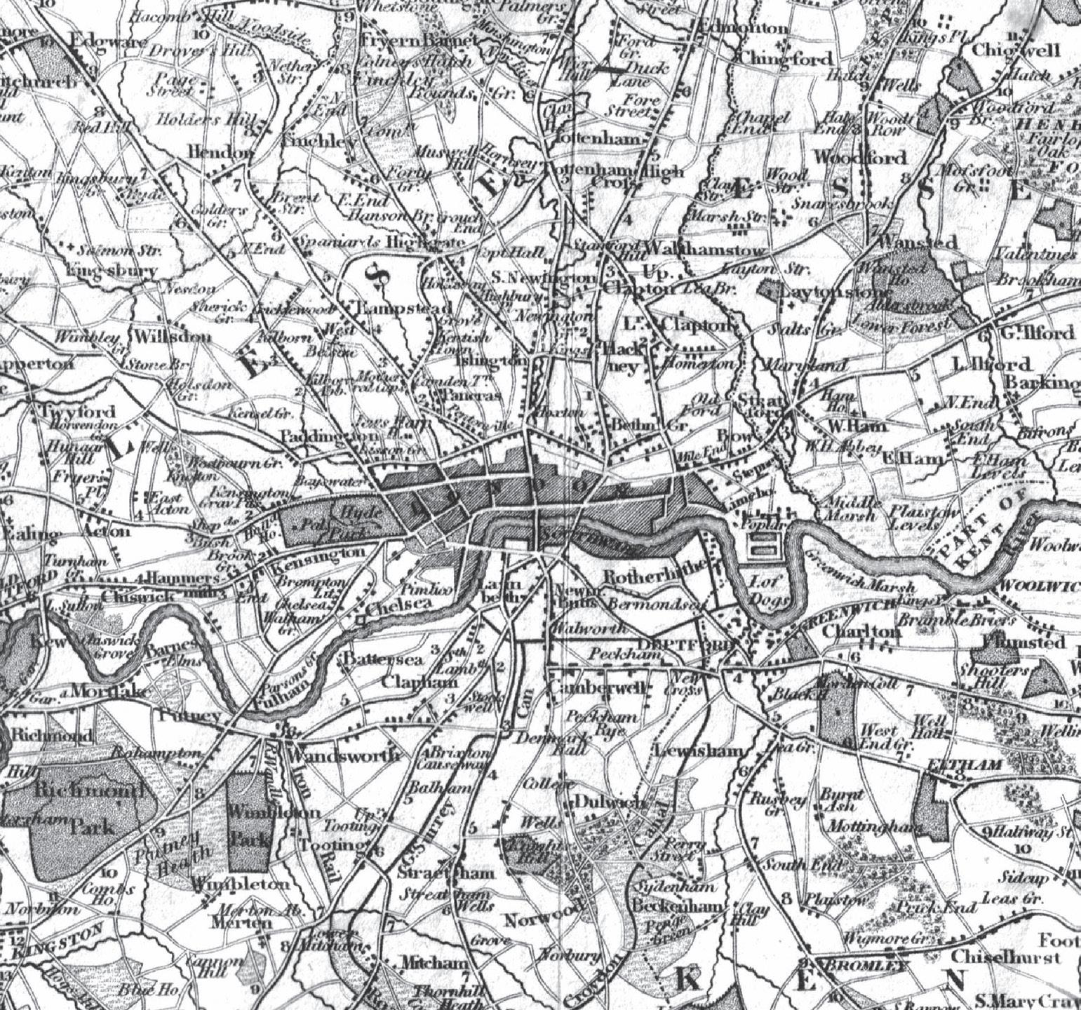
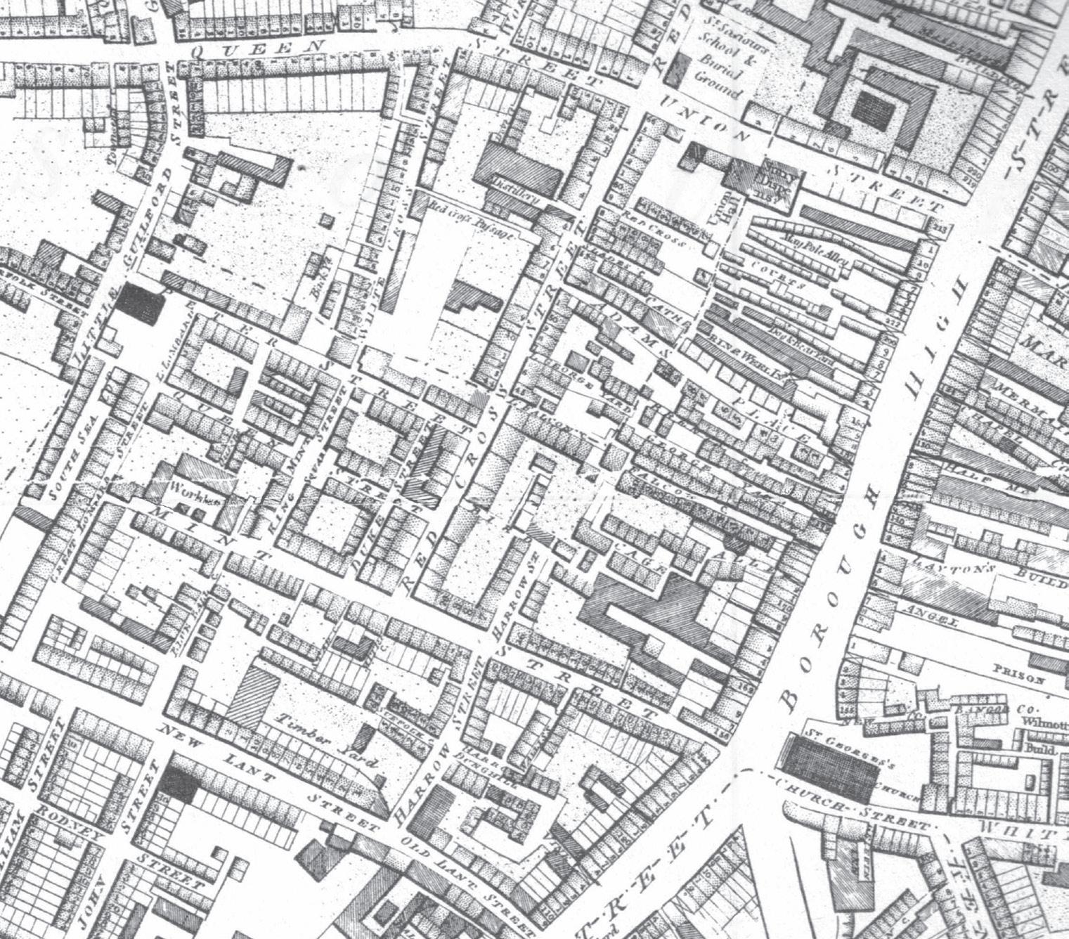
London, 1800
There is no spot like this in the neighbourhood of London, – no spot that looksso murderous, so melancholy, and so miserable. Many of these houses are very large, and very old; many of these courts stand just as they were when Cromwell sent out his spies to hunt up the Cavaliers ...[Y]ears have gathered over this gloomy spot, blackening the steep roofs, and leaving them in all the decay and solitude of silence and neglect. Some of them have slumbered in Chancery, until the very moths have eaten away the names of the original possessors, – until the title-deeds can no longer be deciphered; for there is now no living being to be found, either to claim the titles, or pay the costs. 1
THIS ‘spot’ was the ‘Mint’ or ‘Old Mint’, Southwark, just west of Borough High Street and a ten-minute stroll from London Bridge. It was a place of ‘dilapidated-looking buildings’, many ‘uninhabited, unroofed, and in ruins’, others ‘shored up on all sides by huge timbers’ stretching from ‘blackened walls to the road’ or across the narrow streets or even, like some vast wooden claw, up one side of a tottering house, over the roof and down the other. In the fifteenth and sixteenth centuries this ground had been partly covered by a noble mansion, Suffolk House. Henry VIIIhad chosen a wing of it in which to mint coin. But that was demolished in the early years of Elizabeth, leaving nothing but names – the Old Mint, Mint Street, Suffolk Place, Great Suffolk Street – to mark its gilded youth. Much of what replaced it was over 200 years old in 1800. Some ‘fine old mansion’ might survive, squatting ‘like a drunken giant by the wayside’. One late-seventeenth-
century ‘manor house’ – the Farm House in Harrow Street – carried on its business as a common lodging house for generations, and so did another called the Red House. In and around these great hulks, and behind the three-storey old-iron and sheep’s-head shops on the main streets, their bulging leaded bay windows and dormers and great eaves overhanging the ground floors, were the narrow courts and alleys built up in the backlands, some houses still of timber, many with just two rooms, one on top of the other. Almost everything here was ‘mouldering with age’: when two houses in Lombard Street fell down in May 1814 they killed four of their occupants in the collapse.
This was no tiny enclave. It contained in 1820 some 3,000 families, 1,040 houses, a dozen streets and a maze of courts and alleys behind them. Here the land lay below the high-water mark of the Thames, less than half a mile away to the north. Any drainage was in ditches or ‘open sewers’ and cesspools. And so ‘the sewage in many places bubbles up through the floors’, ‘oozing ...through the pavement of the courts’. The houses were ‘almost destitute of water’, ‘there was no boarding on the floors’ and ‘the inmates slept on the earth, on a few shavings generally’. Small wonder that when cholera first came to London, at the beginning of 1832, it chose the Mint as its earliest and most devastated district. Small wonder, too, that the Mint had traditionally been an alsatia for thieves, prostitutes, debtors, beggars and outlaws, a labyrinthine hidey-hole which bailiffs and police dared not penetrate except in force. In the Mint, ‘We seem to have left civilisation behind us’: ‘every by-court and alley is choking with filth, vice, and crime’.2
Throughout the nineteenth century, with the Mint as one quintessential instance, old London was bad London. Old London epitomised decay, squalor, poverty, disease and disorder. It cluttered, threatened, stank, demoralised, infected, offended the eye. There were, for nineteenth-century Londoners, almost no saving graces in old London, and so virtually nothing worthwhile to be saved of it. Old London and its ways had to be overpowered and obliterated.
Yet what a task. For in 1800 there was so much of it, clustering round the cities of London and Westminster like some ulcerous growth.
We might take a tour, starting in the far south-west. Close to the river was the notorious slum near Westminster Abbey centred on the Almonry, Orchard Street, and Old and New Pye Streets. It lay next to Tothill Fields, on the very edge of London in 1800, and many knew it as the ‘Devil’s Acre’. Caxton had lived in the Almonry and houses there were
thought to date back to his time. Further north were two old pockets of notoriety around St Martin-in-the-Fields at the west end of the Strand and Swallow Street at the east end of Piccadilly. To the west came St Giles, most notorious of all, a City suburb of the 1670s. By 1800 this was the ‘Rookery’, ‘Little Dublin’, ‘Little Ireland’ or the ‘Holy Land’ (an ironic comment on the faithfulness of its obstreperous Irish population to priestcraft). Perched at the eastern end of Oxford Street, even then a fashionable shopping centre for the west end of town, St Giles was an ever-present risk to the shopper, the wagoner or the parcel-carrier. Nearby lay Seven Dials and the streets off Drury Lane. Then the Clare Market area, from High Holborn to the Strand and even down to the river, a nest of seventeenth- and eighteenth-century streets, courts and alleys with an evil reputation: a popular legend claimed that an unlucky wayfarer had entered Portugal Street on his way to the Strand and had never emerged, his ghost still searching for a way back to civilisation.3
Still moving east, touching the north-west border of the City, lay the teeming thieves’ quarter of Saffron Hill, Chick Lane and Field Lane, at the back of the stinking River Fleet: freshly washed silk handkerchiefs, loot from an army of pickpockets, would hang on poles and lines across Field Lane as thick as oak leaves in summer. Then the impenetrable nest of courts and alleys around Turnmill Street, Clerkenwell, which contained Jack Ketch’s Warren. South of this came Smithfield, older than St Giles or Saffron Hill and hardly more respectable: scarcely, too, with its barbaric cattle market, less filthy. Then, moving east again, the old and very poor area between Barbican and Whitecross Street and Golden Lane, St Luke’s.
Bishopsgate and Shoreditch, the ancient road to Cambridge at the eastern edge of the City, marked the beginnings of the ‘east end of the town’. Along this old highway, from Shoreditch to the river, were a mass of overgrown villages grafted to London mainly in the seventeenth century, still with some housing predating the Great Fire of London of 1666. In the north lay the ragged ‘Old Nichol’, the Nichol Street district of Shoreditch and south-west Bethnal Green. South of that Spitalfields and the thieves’ quarter around Flower and Dean Street, Wentworth Street and Rose Lane: here Petticoat Lane was the eastern distribution centre for stolen goods, as Field Lane was further west. South of that, Whitechapel, where scores of slaughterhouses added to the mayhem, and with a warren of lawless courts and alleys around Rosemary Lane and East Smithfield. Between that and the Thames was the mint: old london,1800–185511
squeezed the poor river-plunderers’ district of St Katharine’s-by-theTower. And east from here, along the river to the marshes of the Isle of Dogs, stretched the sailors’ towns that had edged out from London with the growth of the port from Elizabeth’s time: Wapping on the foreshore, Ratcliffe to the north of that and Shadwell to the east.
South of the river, London was many times smaller than on the great north bank. In the east lay the wharfside district of Redriff or Rotherhithe, which, though straggling eastwards, clung tightly to the river. West of that were Horsleydown and Bermondsey, where an inlet of the river at St Saviour’s Dock brought a tidal flow into ditches around Jacob’s Island. Here ancient part-wooden houses had their back walls propped on stilts, their occupants drawing water in buckets from the filthy ooze below. West of Bermondsey came the old Borough, connected to London since Roman times by London Bridge. The district east of Borough High Street had been largely devastated by the Great Fire of Southwark in 1676, though it was quickly rebuilt (the Mint to the west had been spared, thanks to the prevailing wind). Flood, too, was an enemy. At high tides the Thames crept into the courts and alleys, filling basements and swamping ground floors to knee height and more, families having to be rescued by boat. Apart from the ancient fishermen’s and watermen’s district along Fore Street, Lambeth, old London on the Surrey side, virtually ended just west of the Mint.4
So this great ruinous ring of old London was extensive enough. Throughout the nineteenth century it would give all sorts of trouble. We shall have cause to be drawn back to these places time and again when writing of London in the century to come.
But it’s also important to stress that in 1800 much of London was not old at all. Even in its historic heart, the City had largely been rebuilt in the 1670s and 1680s. And the streets built then had more often than not been touched up or rebuilt since as fresh fires or the pressing needs of trade required demolition and replacement. The houses in Cornhill, for instance, new-built after the Great Fire, ‘are all in a more modern stile’, the old houses destroyed by ‘the many fires which have happened at different periods on both sides of the street’.5 Fire would continue to be a potent force for reconstruction throughout the century to come. It was one reason why old London was in fact newer than the maps alone would indicate.
Even more important, since 1666 London had grown vigorously on all sides, most especially in the west. In this ‘west end of the town’ several
the mint: old london,1800–185513
great new towns had been added to the capital in a giant push westward as aristocratic family landholdings were exploited for development. Bloomsbury, on the Bedford Estate, was begun at the end of the seventeenth century and had been building northwards and westwards to Tottenham Court Road ever since. Soho, always more plebeian and cosmopolitan than its polite neighbour on the east, contained London’s artists’ quarter and was a centre of artisanal, bohemian and cultural life. It had been largely completed by 1720. To the west of Soho and some thirty years younger, Mayfair on the Grosvenor Estate had been developed by 1750 right up to Hyde Park (London’s western boundary for the whole of the eighteenth century). So that huge district between Oxford Street and St James’s and Pall Mall was generally not much more than a century old in 1800 and some of it no more than half that.
North of Oxford Street to the New Road (later renamed Marylebone, Euston and Pentonville roads) almost everything was less than fifty years old. From Tottenham Court Road to Edgware Road there were three new towns. West of Cleveland Street, hardly less wealthy suburbs than Mayfair had grown up on the Portland (Cavendish-Harley) and Portman estates in Marylebone; to the east, in what some called North Soho, was a more mixed and plebeian district, aspiring to greater things in Lord Southampton’s estate, where the Adam Brothers were building Fitzroy Square, just south of the New Road. So north of Oxford Street much of the town was spanking new in 1800.
The New Road, connecting the villages of Paddington and Islington and laid down in 1756–7, was commonly accepted as London’s northern boundary in 1800. Indeed, this was a boundary to which London had not yet filled out. Between the Foundling Hospital in Bloomsbury and the New Road were open fields, but beyond them – and so not yet joined to London – were new districts at Somers Town, Camden Town and Pentonville. Even City Road, the south-eastward continuation of the New Road, ran across open country in 1800. Hoxton, south Shoreditch and the western portions of Bethnal Green and Stepney marked London’s edge in the east, although new docks still being built at the Isle of Dogs were drawing a thin line of development along the river through Limehouse to Poplar. Commercial Road, a new highway between the docks and London, was being built by a private company entirely over pasture and market gardens in 1800. These riverside districts were as new-built as Marylebone but for an artisan and labouring class rather than the merchants and professionals moving into the new houses in the west.
South of the river the two new bridges of mid-Georgian London had encouraged development in the suburbs at Lambeth (after Westminster Bridge was opened in 1750) and at St George’s Fields, Southwark (after Blackfriars Bridge in 1769). These were mixed areas, with artisans, clerks and tradesmen jostling for house room with poorer labourers in freshly made ‘back-slums’. So a good deal of south London in the west was less than fifty years old in 1800, with some fresh building still going on, as at London’s edge in the north.
The great lines of communication within this city, despite so much of it being new, largely followed patterns laid down by the Romans seventeen centuries or so before. There was a radial system of eight ancient highways connecting London with all parts of Britain. Most important was the road north to Cambridge and south to the coast through Shoreditch, Bishopsgate, London Bridge, Borough High Street and Newington Causeway: it was London’s backbone. For internal cross-city communications there were three great highways cutting through London west to east. Most northerly ran the ancient road from Oxford to Colchester – Oxford Street, struggling through or round St Giles to Holborn, Newgate, Cheapside, Cornhill, Leadenhall Street, Aldgate and Whitechapel. To the south was a more fractured line from Hyde Park Corner along Piccadilly, then through close streets (or taking in a diversion through Haymarket and Charing Cross) to the Strand and Fleet Street, and meeting Cheapside and the Colchester Road at St Paul’s Churchyard. Each was subject to notorious bottlenecks and ‘what is technically called a “lock”, – that is, a line of carriages of every description inextricably massed and obstructing each other, as far as the eye could stretch...’6 These were worst at the city’s pinch-points, especially where the southern highway met the north at the junction of St Paul’s Churchyard and Cheapside, at Temple Bar where Fleet Street met the Strand, and at the west or Charing Cross end of the Strand. Anywhere the chaos of traffic made life for pedestrians bewildering and dangerous: as in the Strand in 1803, when a broken-down hackney coach brought the traffic to a lock and two men and a woman, trying to cross the road, were trapped between two coal wagons and were crushed to death, ‘notwithstanding their screams and shrieks’.7 And in 1800 nearly all of London’s enormous traffic was carried on roads of gravel poured on clay, which cloyed and hampered hoof and wheel and foot alike in wet weather.
The third highway was London’s river. Some 3,000 boats and wherries plied for hire on the Thames in the early nineteenth century. Many were employed in cross-river traffic, the Thames a barrier to communications
within London but still its greatest source of trade. For 1,700 years there had been just one permanent river crossing. In 1800 London Bridge was still Peter de Colechurch’s near-immortal structure, finished in 1209. The massive piers of his bridge – eighteen after one was removed in 1758–60 –so held back the tidal flow that the difference in water level between one side of the bridge and the other was some five feet. Shooting the rapids at London Bridge was a thrill for even time-served watermen, and certainly their passengers. Every year people died doing it: four sailors drowned out of six when a cutter went down in August 1811, for instance. George Borrow, fresh from Norfolk, watched a small boat shoot the bridge, ‘the boatman – a true boatman of Cockaigne that – elevating one of his skulls in triumph, the man hallooing, and the woman, a true Englishwoman that– of a certain type – waving her shawl’.8 The restricted flow at London Bridge was the main reason for the river freezing, as it did spectacularly in early 1814, and one factor among others in the severe flooding of the Thames (1774, 1791, 1821, 1827) and the Fleet (1809), inundating mainly Lambeth, Southwark and Westminster.
The volume of bridge traffic was enormous even in the early years of the nineteenth century. On one day in July 181190,000 pedestrians, 5,500 vehicles and 764 horse-riders crossed London Bridge, which was just twenty-one feet wide. Blackfriars carried about two-thirds as much. George Borrow recalled his astonishment at first seeing that
Thousands of human beings were pouring over [London] bridge. But what chiefly struck my attention was a double row of carts and wagons, the generality drawn by horses as large as elephants, each row striving in a different direction, and not infrequently brought to a standstill. Oh the cracking of whips, the shouts and oaths of the carters, and the grating of wheels upon the enormous stones that formed the pavement!9
There were thought to be over 30,000 vehicles in London in the preomnibus era around 1813, including 1,100 hackney coaches for hire and even 400 sedan chairs. Traffic staggered visitors to the city. In the West End the noise, for French-American traveller Louis Simond, was ‘a universal hubbub; a sort of uniform grinding and shaking, like that experienced in a great mill with fifty pairs of stones...’10
The great avenues of communication east and west and north and south connected but did not unite the metropolis. There were, contemporaries explained, three Londons, divided by class and economic function.
The west end of town was home to court, Parliament and government. Here a wealthy leisured class enjoyed the relatively clean streets of Mayfair and Marylebone, living mainly on rents and investments which were cultivated and nurtured in the City. This was the second great London, based on money and commerce, with its own now ageing suburb in Bloomsbury. To the east of the City, in the ‘east end of the town’, was the manufacturing district and port, a workers’ city, self-sufficient and isolated from the metropolis at the centre and in the west.11
These age-old divisions were, even by 1800, too unsophisticated to encapsulate London’s diverse social topography. For plebeian London, as represented by manufacturing, penetrated every district, even the smart West End, where tailors and goldsmiths and carriage-builders brushed coat-skirts with gentlemen of private means. It was even denser in Soho and it overwhelmed the cluttered ring of old London round the edge of the City and Southwark. In fact, manufacturing in 1800 was strongest of all in the City itself, not yet – and not for a long time – turned over exclusively to the circulation of commodities and capital. The manipulation of money may have been the City function of most interest to the West End, but manufacturing was by far the greatest employer of City labour. The City remained a residential and industrial district beyond the first half of the nineteenth century, with artisans, clerks, warehousemen and shopmen living nearby or ‘over the shop’. So workers skilled and unskilled – even casual labourers and beggars – could be found living almost anywhere in London. The popular polarity of ‘St Giles and St James’, used to describe the vast spectrum of poor and rich in London, disguised the fact that these irreconcilables were even closer to home. Westminster, even Mayfair, had its spots of poverty and squalor, sometimes infamously so.
With these complications in mind, the three Londons identified by contemporaries can be augmented by a fourth: old London’s City fringe and Borough belt of poverty and wage labour that on the one hand threatened London with disorder and disease and on the other provided and sustained its very means of existence. And already in 1800, crosscutting these four swathes of the metropolis, were some specialist neighbourhoods of long standing: law and letters near Temple Bar at the western edge of the City, bookselling and publishing at Paternoster Row by St Paul’s, silk weaving in Spitalfields and Bethnal Green, leather curing in Bermondsey and half a dozen more that would be greatly multiplied as the new century matured.
Despite its complexity, and compared with what was to come, London was a small city in 1800. It was some five miles from Hyde Park Corner to Wapping and just over two from Sadler’s Wells, Clerkenwell, to the obelisk in St George’s Fields, Southwark. So this was a walkable city even though its sixty squares, 8,000 streets and uncountable courts and alleys were just too dense and occult for any one person to know intimately. ‘London is a giant,’ commented Louis Simond in 1817, ‘strangers can only reach his feet.’ For even at that time London was Europe’s greatest city in extent and population. Its built-up area contained about 783,000 people, and there were a further 176,000 in the nearby villages and towns that would later merge in the County of London. The population of what would become Greater London brought the whole to just over 1.1 million in 1801. 12
London’s built-up area contained one in twelve of the people of England and Wales, a much smaller proportion than would be the case a century later. But even in 1800 there is no doubting the extraordinary power that London wielded over the minds and fortunes of the people of the British Isles. The young Thomas de Quincey was nearly fifteen when he journeyed from the West Country in the May of that year and ‘first entered this mighty wilderness, the city – no! not the city, but the nation – of London’.
Often since then, at distances of two or three hundred miles or more from this colossal emporium of men, wealth, arts, and intellectual power, have I felt the sublime expression of her enormous magnitude in one simple form of ordinary occurrence – viz., in the vast droves of cattle, suppose upon the great north roads, all with their heads directed to London, and expounding the size of the attracting body, together with the force of its attractive power, by the never-ending succession of these droves, and the remoteness from the capital of all the lines upon which they are moving.13
Yet paying homage to this mighty metropolis by visiting it or moving there could be a difficult venture in 1800 and for forty years to come. A sea passage was the most convenient way to get to London from Cornwall, say, or from the far north. William Jerdan, a notable London journalist of the 1840s, was a Scot from Kelso. His first journey to London in 1801 involved coaching from Edinburgh to Berwick and then sailing in a smack to Wapping: it took him nine days. Paddle steamers would cut the journey time by the 1830s but even in 1842, when Alexander Bain left Aberdeen
for London, he coached to Edinburgh and then was three days at sea; returning direct to Aberdeen by fast clipper took him five days, though it was a more comfortable passage for ‘bad sailors’.14
Coaching from other parts of England was slow, uncomfortable and hazardous, especially when the coach neared London. Mrs Lynn Linton recalled that around 1830 a south-going coach ran twice a week through Eden, Cumberland, and the journey took three days and two nights. Dover was an eleven-hour trip around 1815 and express to Exeter took twenty-five hours. Even so, the volume of traffic was extensive. There were over 400 coaches from London, most leaving daily to all parts of the nation. As they returned, approaching London the numbers of passengers swamped the coaches available. ‘It is not unusual,’ it was reported in 1806, ‘to see ten on the roof, three on the box (besides the driver), four behind, on what is called the “Gamon Board”, and six on the dickey or chair; in all, often above thrice the number intended to be allowed.’ When the Croydon coach overturned that year with sixteen outside passengers, two were killed and several injured.15
When visitors reached the metropolis they were generally amazed by what they saw. Its size stunned them and so did the grandeur and immensity of its great buildings. A first view of St Paul’s ‘overwhelmed us with awe; and I did not at that time imagine that the sense of magnitude could be more deeply impressed’. The city’s street lighting by oil lamps ‘had a most striking effect, particularly at a distance, and to strangers’. Even the primitive road surfaces and paving and litterpicking were considered exemplary compared with elsewhere, at least in the smarter parts of the town. And London’s discomforts could impress as greatly as its ‘Tumult and blaze’, most notably its smoke and fog: the approach of London could be smelled and tasted on the wind for miles away, and the whiff of smoke ‘could always distinguish a London letter ...on putting it to the nose’.16
More impressive perhaps than all of these were Londoners themselves. Their sharpness, showiness, fashion-consciousness, arrogance and liveliness were admired or despised but could not be ignored. So Bob Tallyho, the country cousin of Tom Dashall in Real Life in London (1821) is made to say, ‘If an acquaintance with London is to give a man these airs of superiority – this ascendancy – elegance of manners, and command of enjoyments – why, London for me...’ William Jerdan thought ‘a lad of sixteen or eighteen, educated in the country, knew less of other life, than a smart English child brought up in the capital ...of only eight or
the mint: old london,1800–185519
ten years old’. And ‘The superiority of metropolitan society cannot be disputed, and its more enlarged and liberal modes of thinking and acting,’ wrote Cyrus Redding, a Cornishman who came to London aged twenty in 1805. 17
London’s place in the nation enlarged as the nation itself grew in population and extended its influence around the world. London would become – like Rome, its only true forebear in history, with which it was much compared at the time – the Imperial City. But before it could don the purple, the metropolis had to be made fit for the task.
Cyrus Redding, who wrote his compliment to metropolitan society in 1858, concluded, ‘but neither then nor now, had I or have I, any affection for blackened brick walls, interminable streets, rattling vehicles, howling costermongers, wretchedness, poverty, and vice, made more deplorable and vicious by close contact with dissipation, wealth and luxury’. Many of Redding’s criticisms would never be successfully resolved. But all, in some way, would be addressed in the nineteenth century. And in making London fit for its status as the greatest city the world had ever seen, efforts would begin first on the ground. There were three great driving forces that would tackle the job of transforming London’s built environment. Though there was much overlap, they operated mainly in sequence. First, the crown – king and government together; second, private enterprise; last, London’s local government.
‘The
ROMEof Modern History’, 1800–1830
From the end of the Napoleonic Wars to 1855 the crown led the attack on old London. But before 1815 the forces of change were more mixed. And first honours must go to the City Corporation for pushing forward schemes that had their origins in the early 1790s.
These were the City entrance improvements. Their originating genius had been Alderman William Pickett, a silversmith elected Lord Mayor in 1789–90, and a radical whose second claim on posterity’s attention was his demand that Pitt’s ministers remove the armed guard from the Bank of England as an ‘unnecessary introduction of the military into the civil government of the nation’. In that he failed. But his first and more successful claim was to steer through the Corporation’s creaking bureaucracy the improvement of two ancient ways into the City from Middlesex and Westminster. His success was won ‘after many and great
oppositions’. And it was a victory he never lived to see, the improvements taking shape some few years after his death in 1796. 18
In the north-west of the City at the border with Holborn, Snow Hill had been ‘for ages one of the most inconvenient and dangerous passages within the metropolis’. It was twisting, narrow and steep. Pickett proposed a new street to bypass Snow Hill in ‘a gentle ascent’ from Holborn Bridge to Newgate, taking down some ‘decayed and wretched’ houses in Old Bailey in the process. Demolition began about 1801 but the resumption of war in 1803 and consequent uncertainties delayed construction. In 1806 some grand houses by George Dance the Younger in the new Skinner Street – named after another improving alderman, lately defunct – were put up for disposal by lottery.19
Even more important were improvements at the ‘court end’ of the City, where the Strand joined Fleet Street at Temple Bar. The Bar itself – ‘that leaden-headed old obstruction’20 designed by Wren and forming a narrow gateway across the road, marking the boundary between Westminster and the City – had been under threat of demolition for a generation. But these improvements, which also began about 1801, left Temple Bar to be a curse to carters and cabbies for seven decades and more to come. They did, though, demolish Butcher Row around 1802, a narrow street on the north side of the Strand: ‘a dirty place, composed of wretched fabrics and narrow passages ...The houses overhung their foundations, the receptacles of dirt and disease, and the bane of London.’ The Strand was widened at this point and the side north of St Clement’s Church was renamed Pickett Street. There were improvements beneath the surface too. The ancient leaky sewers here ran at cellar depth to the Thames and forced filth into houses, making them ‘damp and noisome in the extreme’. So they were replaced by sound and deeper sewers which did a better job of dumping the city’s excrement into the river. There were other improvements around the same time in Jewin Street, Aldersgate; and dozens of ‘low buildings’ which ‘choaked up’ the approaches to the Houses of Parliament and Westminster Abbey were removed around 1804. 21 Neither of the City entrance improvements would last long. Skinner Street was removed for Holborn Viaduct in the 1860s and Pickett Street for the Law Courts ten years later. This reminds us that London, even new London raised on the rubble of the old, was ever renewing itself. One reason for such short lives may have been the Corporation’s inattention to taste, for ‘certainly the useful was more sought after than the ornamental by the then city Vitruvius’. This was a complaint that
the mint: old london,1800–185521
would be heard again, in other parts of London, and for a long time to come. At the time, though, the City entrance works were a source of great astonishment and pride to Londoners. William Blake, returning to the city in September 1803 from a three-year stay in Sussex, noted his impressions of a place changing rapidly for the better: ‘The shops in London improve; everything is elegant, clean and neat; the streets are widened where they were narrow; even Snow Hill is become almost level and is a very handsome street, and the narrow part of the Strand at St Clement’s is widened and become very elegant.’22
Beyond the well-filled coffers of the City Corporation, the war years to 1815 were a difficult time for home investment, shaking confidence and damaging trade. Even so, a surprising number of projects involving risky but extensive private financing were begun. Some would have momentous significance for the shape of development in London for the century to come and beyond.
The London Docks, with their great warehouses and thief-proof wall that rambled for miles along the streets of the East End, required the demolition of ‘straggling houses’ and ‘inferior streets’ in Wapping and St George’s in the East, south of Ratcliffe Highway in 1801–2. In St George’s, ‘twenty-four streets, thirty-three courts, yards, alleys, lanes, and rows’ were cleared, ‘a distinct gain to the sanitary conditions of the parish’.23 City redevelopment for the Stock Exchange in Capel Court (1801–2), the Auction Mart (1808–9) and the Mincing Lane Sale Rooms (1811–12) expanded not only specialised exchanges at the expense of the coffee houses but removed cheap, decrepit old property as a consequence. And the formation of Great Dover Street from 1809 better connected London Bridge to the old road to Kent, bypassing the ruinous, narrow and dangerous Kent (later Tabard) Street and taking many old courts and alleys with it. The road was built by a private company relying on turnpikes and tolls to produce a 5 per cent dividend for the shareholders.
A different kind of private venture was the contemporary utilisation of coal gas for lighting by a Scot, William Murdock, in his Soho factory (1802) and by a German adopted-Londoner who anglicised his name to Frederick Albert Winsor. Winsor lit the gardens of Pall Mall and the Prince of Wales’s Carlton House in the summer evenings of 1807 to demonstrate the utility and beauty of his invention. Investors were drawn to the flickering flames. Yet cash was scarce and things moved slowly. Five years later, with Winsor as founder, the Gas Light and Coke Company began the task of lighting London north of the Thames.
But gas lighting did not become generally used in London’s streets until the early 1820s and was not universal till about 1842. 24
Just as important as gas lighting, even more so for the future remoulding of London, were the three great bridge schemes brought forward before 1815. Each was the product of private investors buying shares in the bridge project and reaping dividends by way of tolls.
In 1800, as we saw, there were just three river crossings at London Bridge, Blackfriars and Westminster (the eighteenth-century wooden bridges at Battersea and Putney were too far out to be considered part of London at the time). Traffic volumes were so high they seemed to make any new bridge an attractive investment. Interest was sufficient to float as many as three new ventures, initiated by companies sanctioned by Acts of Parliament in 1809 and 1813. Vauxhall (first called the Regent Bridge) linked Pimlico to Vauxhall in Lambeth, at the southwest extremity of the town. Waterloo (at first called the Strand Bridge) connected the Strand and Covent Garden with Lambeth. And Southwark joined the City to Bankside. Vauxhall Bridge was the first of London’s iron bridges. Designed by James Walker, it opened in 1816. Waterloo, by Scottish engineer John Rennie, was considered ‘the finest bridge in Europe’ of its day. It opened in 1817, on the second anniversary of the battle that renamed it. But it proved a white elephant to its backers, too close to the free bridge at Westminster for those who would not bear its halfpenny tolls for pedestrians, more for vehicles. Southwark Bridge, once again by the indispensable Rennie, also of iron and ‘brilliantly lighted’ with thirty gas lamps, was opened in 1819. 25
Each bridge involved building new approach roads to bring traffic swiftly and safely to and from them. These connecting highways were essential components in making the bridges profitable. The greatest effects would be felt on the Surrey side, where Vauxhall and Waterloo bridges in particular stimulated vigorous house-building activity over marshy wilderness and market garden alike. It was these bridges in particular that transformed development prospects south of the Thames. John Britton, a notable London-watcher and antiquary, observed in 1826 how it was now right ‘to have its ancient name of South-wark changed into the more appropriate one of South London, which is occasionally applied to it’.26 There were consequences too for old London, as Southwark Bridge Road drove through the Tudor and Stuart remnants of Bankside, long known for its filth and disorder. But the proprietors of the new road fought shy of the difficulties of cutting
through the Mint, swerving round it at its western edge.27
These three new bridges were giant projects. But they would seem as nothing to the vision and sweep of what was being planned and pegged out on the ground in the West End from 1811.
Pickett has been largely overlooked by history but John Nash, and of course his resplendent patron George IV, shine out still in the annals of London in modern times. George may have been gross, lascivious, quixotic, prodigal and spiteful, but he was the only monarch to combine energy, even passion, with all the resources of the crown for the greater glory of London. And Nash, his chosen vehicle for implementing and moulding his wide ambitions, may have been sycophantic, slapdash, pinchbeck, nepotistic, even venal, but he was a planner and designer of genius. What they achieved together between 1811 and 1830 was unprecedented in its day and is unmatched since.
It all began in the fields just north of the New Road. The Marybone or Mary-le-bone Park was crown land leased mainly for farming. To the south, since at least the 1760s, aristocratic landlords had made a fortune cutting up pasture into streets and squares for the wealthy. The leases of Mary-le-bone Park were to end in 1811. That provided an opportunity for the crown to share in the building speculations of its neighbours.
From the 1790s the stewards of crown property – the Commissioners of Woods and Forests and Land Revenues – had given thought to just how such a speculation might work on the ground. Their surveyorgeneral, John Fordyce – yet another talented London Scot – was the first to suggest a road which would link development land at Mary-lebone Park with the Houses of Parliament at Westminster. In that way a gentleman in the new suburb could gain easy access to the business of state. It is Fordyce who must be credited with the skeleton of the plan which Nash so brilliantly and so pertinaciously followed through.
Nash could have done nothing, of course, had it not been for his relationship with the Regent, becoming close about the time the leases fell in. The Regent was an aggrandiser with a passion for building who saw in the ‘beautification’ of London glory to himself and his metropolis, and a stab at the pretensions of his enemy across the Channel. Nash’s plan would ‘quite eclipse Napoleon’ in the contest of the nation’s capitals. And George did not know, in either the bedroom or the counting house, the meaning of the word extravagance.
What of the plan itself? Mary-le-bone Park would become the the mint: old london,1800–185523
Regent’s Park, combining pleasure ground and manicured landscape for rich men’s country villas. It would be the beginning of a new town, complete with market and barracks for the Life Guards to protect life and property. Regent’s Park would become an important component in the growth of new London from 1820.
But the New Street – finally to be called Regent Street – designed to connect the park with Westminster, carved a wide canyon through old London. In the north it extended Portland Place, a sequestered ‘“close” of great houses’ built partly by Robert Adam on land leased from the Duke of Portland, with an elegant crescent facing the New Road and the entrance to the park. Nearly 200 years on, the six-storey stucco frontages of Park Crescent and its neighbours remain one of the architectural highlights of London. To the south, the new street joined Portland Place slightly to the east. The two were connected by Langham Place and All Souls’ Church. A new circus at Oxford Street led into the main line of Regent Street south to Piccadilly.
We should pause here, because the precise choice of where the new street should run from Oxford Circus was very much Nash’s own. In selecting it he had an explicit social purpose. In Fordyce’s time a street further to the east, somewhere along the line of Great Portland Street through Golden Square, had been envisaged. But Nash exploited the obvious fact that Soho and the West End were vastly different social milieux and that the dividing line between the two was broadly along the line of Swallow Street, further to the west. If the eastward line were taken, then the new street would have decrepit seventeenth-century property on both sides. But if Swallow Street were followed, then Regent Street would clearly mark the great divide – no less than 120 feet wide and with palatial six-storey shops and residences on both sides – between aristocratic London in the west and plebeian London in the east. And if Swallow Street went, then so would its ‘filthy labyrinthine environs’ and ‘dirty courts’ filled with the poor. Years later it was recalled how ‘thousands of poor were driven into the Strand, St Giles’s, Lambeth, and other parts’ by Nash’s housebreakers.28
This social objective assumed determinative importance for Nash, as it did in the minds of the Regent, a parliamentary select committee and ministers. We know this because choosing Swallow Street as the route presented considerable architectural and practical difficulties in bringing the new street to the eastern end of Piccadilly. The solution, costly but brilliant, was to sweep the new street to the east in a quarter-circle or
Quadrant. This was difficult to achieve. The two curved terraces had to be built as single pieces rather than cut into separate building plots and sold to individual clients or speculators, as in the rest of Regent Street. It was so problematic that Nash himself had to take on the Quadrant as one job, rewarding his contractors with leases in the new terraces in lieu of cash. The Quadrant was given an unusually continental feel, with a colonnade on slim iron pillars, shielding pedestrians from the elements. The south-east end of the Quadrant dropped into a new circular space for many years called Regent, later Piccadilly, Circus.
From there it was intended that Lower Regent Street would lead directly south to George’s town palace at Carlton House. But by 1825, with Regent Street built up, George had chosen Buckingham House on the borders of undeveloped Pimlico as his new palace. Carlton House was demolished and replaced with grand terraces either side of an open vista into a refurbished St James’s Park. So the great scheme ended – entirely through happenstance – in parkland both north and south. It was the Regent’s Park and Regent Street that James Elmes had most in mind when he called London ‘the ROMEof Modern History’ in 1827. 29
Who paid for this majestic vision? The crown had retained the freehold of much of west Soho as a result of earlier speculations and land exchanges. Regent Street was 1,700 yards long and 1,250 of those ran over crown property. But the rest had to be acquired by compulsory purchase involving parliamentary inquiries and an Act of Parliament. Nash had underestimated the value put on the property to be acquired, especially the ‘goodwill’ claimed by the shopkeepers, artisans and stablekeepers of Swallow Street. Nash’s first forecast had been £385,000. The final cost to the public purse – borrowed mainly on mortgage from insurance companies – was £1,533,000. This would be remembered by all opponents of state extravagance in the years to come, even though the rising value of freehold property assuaged the debt many times over.30
There are three other points worth making here about this remarkable scheme. One was the continuing regard in which the overall plan was held by posterity, despite much criticism at the time. Not all contemporary opinion was against Nash by any means, and nor was it even a generation after the event. But his close ties with George, a much loathed monarch for many good reasons, brought opprobrium on him by association. And the evangelical conscience, which especially hated George’s deplorable vices, identified in Nash’s passion for stucco a
meretricious attitude to art and life that made Regent Street quite literally a whited sepulchre for many Victorians.
Second, and more down to earth, was the boost to Westminster’s sewerage that the new street provided. It added a third great new sewer to the existing structures that channelled filth to the Thames, just as Pickett Street had done for the west of the City.
Finally, there was the speed with which it was all done. The act permitting procurement was passed in 1813. The street was nearly all completed by 1820. In nineteenth-century London that was astonishingly quick, although some larger properties on the street were still being built until 1824. And the demolition of Carlton House and its replacement terraces and gardens had to wait till about 1833 for completion.
By that time Nash had been moved to one side and George, who died in 1830, removed entirely. But their grand plans lived on in the ‘West Strand Improvements’. These cleared an old conglomeration of ‘vile houses’ from around St Martin-in-the-Fields,31 and continued Pall Mall into the new square forming in front of the National Gallery (1832–8). Trafalgar Square itself took from 1829 to 1841 to lay out, and Nelson’s Column was not completed till 1849. These were the leisurely timescales more usually associated with the development of old London, especially after the death of George IV. But Nash’s priceless vision eventually resulted in London’s greatest civic space. ‘The year 1825 will ever be memorable in the annals of London; for within that period more novel improvements, changes, and events have occurred in the metropolis, than during any other corresponding extent of time.’32 The 1820s was the most momentous decade of change in old London since the 1660s.
A number of other huge projects were getting off the ground as Nash’s great plan entered its final phase. Of these perhaps the most influential was the City Corporation’s demolition of London Bridge and its replacement slightly upriver by a new Rennie-designed structure (1823–31). The new bridge brought about extensive demolitions at the City approach, most notably for the new King William Street running north-east almost to the Bank. But this was not all progress. A Wren church, St Michael’s Crooked Lane, was demolished. And some smaller clearances on the Surrey side included the remains of an AngloNorman priory. Very little of old London would be considered indispensable until much later in the century.
Also on the river, this time to the east of London Bridge, extensive clearances of old and very poor clapboard-covered housing made way
for a new private venture, St Katharine’s Dock (1824–8). Thomas Telford was the engineer on this project to build a dock closer to the centre of London than had ever been attempted before. In a poverty-stricken and lawless district, places with evocative names like Dark Entry, Cat’s Hole, Pillory Lane and Rookery were wiped from the face of London. Some 1,250 houses were demolished and 11,300 people thrown onto the streets, probably more than twice as many as for Regent Street. These evictions were remarked upon less than the demolition of the ancient St Katharine’s Hospital and the parish church of St Katharine’s-by-the-Tower. Here some protests did occur, ending in a service for ‘sixty poor children of the precinct’, recipients of a local charity. ‘They were the offspring of a neighbourhood of ill-fame, whence, by liberal hands, they had been plucked and preserved as brands from the burning fire.’33
Around the same time, further crown projects didn’t involve Nash. The most far-reaching of these was the extension of the bureaucratic quarter in and around Whitehall. This involved the long-term redevelopment (from about 1796 to 1830) of Great, Middle and Little Scotland Yards, and rebuilding the Whitehall frontage north of Downing Street. Grand offices for the Privy Council and the Board of Trade were completed to a design of Sir John Soane in 1827. But this was a transformation with still a long way to go. There was a ‘dirty publichouse’ on the corner of Downing Street and a ‘row of third-rate lodginghouses between that and the Foreign Office’ until 1839. And there were private residences in Whitehall for the rest of the century.34
More suggestive of the multi-layered social objectives of London improvements at this time is the story of the General Post Office. Since 1690 this had been in Lombard Street, the ancient centre of City banking. But it was too cramped for business and too decayed for official comfort and its removal had been mooted since 1789. The site chosen for the new GPOwas in St Martin’s-le-Grand and negotiations were under way in respect of it by 1813. Its selection was not merely commercial opportunity. The Office of Works – whose responsibility it was – had been guided to the site by the City Corporation, who offered to pay onethird of the purchase price of the land. The reason for the Corporation’s largesse lay in the nature of the property there. It was the most notorious concentration of hovels and brothels in the City, ‘infested with low women and strumpets of the worst description’. Round Court, New Rents, Mouldmaker’s Rents (or Row), Dark Entry (again) and other places including ‘a narrow passage, commonly, and not improperly,
called Little Hell, leading into Bagnio Court’ – most too small for even the mapmaker’s art – occupied the whole of the east side of St Martin’sle-Grand. The new Post Office swept them all away. Purchase of the site, and possibly some demolitions, began in 1814, and around 1,200 people were evicted. But the new Post Office, after various financial problems, confusion and failures of nerve, did not finally open for business – to a design by Sir Robert Smirke – till 1828. 35
Two years later, on 26 June 1830, George IV died. A reaction against the costliness and ostentation of his metropolitan improvements had already found loud voice. John Nash had been cross-examined by a parliamentary committee on the refurbishment of Buckingham Palace and found wanting. Eventually it would conclude that he had been ‘chargeable with inexcusable irregularity and great negligence’.36 The Duke of Wellington, then Prime Minister, blocked a baronetcy for Nash requested by George in 1829. But these were nothing to the backlash against luxury and improvidence that followed George’s death. Every moral flaw that frail George had so openly flaunted during life seemed to swagger on in the dressy lavishness of his metropolitan improvements. Nash was dismissed as architect at Buckingham Palace and work there was suspended. And the reign of the retrencher and the tightwad – who had agitated from the wings for many years – began.
‘Embellishment Subordinated’, 1830–1855
Posterity never complains of extravagance in public works. But it almost always does of parsimony. Nash’s plan for Regent’s Park and the new street had been drawn up under three headings: ‘Utility to the Public’, ‘Beauty of the Metropolis’ and ‘Practicability’. Henceforth, as the Select Committee on Metropolis Improvements put it in 1838, ‘Embellishment’ would be ‘regarded as a matter of subordinate importance...’37 The ‘beauty of the metropolis’ as an object of public policy died with George IV and would hardly be resurrected in the nineteenth century. Almost every metropolitan improvement begun after 1830 would suffer in some way from lack of care in design and appearance. Some suffered so badly that they would be objects of scorn for generations to come, opportunities disastrously squandered in the interests of short-term financial prudence, or penny-pinching.
Yet metropolitan improvements could not stop altogether – or, rather,
the mint: old london,1800–185529
they could not do so for long. At first the 1830s were as barren for the modernisation of London outside the City as the 1820s had been fruitful. But during the 1830s the pressures for change would build up and eventually overbear the forces of restraint. And the forward momentum was generated more than anything else by socio-political considerations rather than the commercial or communication needs of the capital.
Even up to 1830, the social objectives of redevelopment had often been explicit and important factors in metropolitan improvements. Butcher Row, Swallow Street, St Martin-in-the-Fields, St Katharine’sby-the-Tower, St Martin’s-le-Grand, all had been shortlisted for clearance – even selected – on grounds of social expediency. Whatever the purpose for which replacement was sought, the removal of old London back-slums, and the ruthless dispersal of troublesome, dirty, pauper populations was a bonus that could clinch parliamentary support and statutory powers of purchase and demolition. After 1830, despite all the urgings of economy to do nothing, it was these social objectives that fashioned an irresistible imperative for change.
The first three years of the decade were greatly troubled. The revolutions of 1830 in France and Belgium warned of the power of a disgruntled people. There were London riots against the new king and Wellington when the latter declared against parliamentary reform at the end of the year. Pro-reform agitation made London’s streets tense and occasionally violent until the Great Reform Act passed into law in June 1832. Even after that the ultra-radicals and organised workers kept the London authorities busy with political meetings, strikes, protests over the New Poor Law, the resurgence of London reform associations in 1836 and the birth of chartism a couple of years later.
Early in 1832, cholera had come to London for the first time. Its victims fell mainly in the worst districts of old London, especially south of the Thames. The rich were spared and many were blasé as a result. But for those in government, and in the ranks of a still-primitive civil service battling with a disease they didn’t understand, the cholera epidemic was an enlightening moment. We can see, in the response of Charles Greville, Clerk to the Privy Council, the first stirrings of a social conscience that would find increasingly vociferous expression as the century grew older.
The awful thing is the vast extent of misery and distress which prevails, and the evidence of the rotten foundation on which the whole fabric of this gorgeous society rests, for I call that rotten which exhibits thousands upon thousands
of human beings reduced to the lowest stage of moral and physical degradation ...I believe a general uncertainty pervades every class of society, from the highest to the lowest; nobody looks upon any institution as secure, or any interest as safe...38
What to do about the poor, how to reduce their cost to the nation, how to prevent the crimes they committed and the diseases they spread, how to suppress the political instability they provoked, these were the most pressing questions of the 1830s. They pressed hardest in London because there the poor seemed to pose the greatest danger to the wealthy and to the very institutions of state. The poor threatened most acutely when they congregated in large numbers in ill-drained, tight-clustered, crumbling districts. Here they were impervious to police, to the civilising influences of religion and education, even to the fresh air that might disperse the stinking ‘miasma’ thought to be the agent of epidemic. Here discontent was bred in the bone. And just such districts formed that huge intractable girdle round the great cities of Westminster and London. How were these districts to be improved? From the cholera onwards, the local and religious authorities of the metropolis petitioned Parliament for help in dealing with their troublesome enclaves. Parliament responded by setting up a Select Committee on Metropolis Improvements in 1836. Its second report (1838) dwelt on one solution. There was no better way – indeed, no other way available at the time – than to drive new streets through the worst parts of London.
There are some districts in this vast city through which no great thoroughfares pass, and which being wholly occupied by a dense population, composed of the lowest class of labourers, entirely secluded from the observation and influence of wealthier and better educated neighbours, exhibit a state of moral and physical degradation deeply to be deplored ...The moral condition of these poorer occupants must necessarily be improved by immediate communication with a more respectable inhabitancy; and the introduction at the same time of improved habits and a freer circulation of air, will tend materially to extirpate those prevalent diseases which are now not only so destructive among themselves, but so dangerous to the neighbourhood around them.39
In choosing which areas to ‘ventilate’ first in this way, improved traffic communications would be an important objective but not determinative. The dangers offered to London (and to better-off Londoners) through crime and disease would prove most important of all. And in
effecting the improvements, cheapness would be a vital consideration. First, because the public purse, which had to borrow for purchase, demolition and street works – to be recouped over the years from building leases and improved ground rents – was more cash-strapped in the 1830s than at any other time in the nineteenth century.40 Second, because the bungled cost control of the new Houses of Parliament, rebuilt after the fire of 1834 amid bitter wrangles over their design, focused parliamentary interest on value for money in public works at just this time.
If money was scarce, then priorities had to be chosen wisely. The top three troublesome districts where new streets were needed were identified by the select committee of 1838. First, the Rookery of St Giles, Holborn. Second, the Rose Lane and Essex Street area of Spitalfields and Whitechapel. Third, a new road to Pimlico through the Devil’s Acre behind Westminster Abbey. Here were the lucky populations whose ‘moral condition’ would be improved by mass evictions and homelessness. Here were the people who made way for New Oxford Street, Commercial Street and Victoria Street.
It was really no surprise that the Rookery was chosen as the first bastion of the poor to fall. It was a very old concentration of misery and crime, home especially to a ragged Irish population since the eighteenth century. The Rookery was a small but dense district bounded by Great Russell Street, Charlotte Street, Broad Street and High Street: ‘Within this space were George Street (once Dyott Street), Carrier Street, Maynard Street, and Church Street, which ran from north to south, and were intersected by Church Lane, Ivy Lane, Buckeridge Street, Bainbridge Street, and New Street. These, with an almost endless intricacy of courts and yards crossing each other, rendered the place like a rabbit-warren.’ Buckeridge Street was full of thieves’ and prostitutes’ and cadgers’ lodging houses at fourpence a night or threepence in the cellars. Jones Court was ‘inhabited by coiners, utterers of base coin, and thieves’, and its cellars connected with those in Buckeridge Street by short tunnels or holes just two feet high. Rat’s Castle, Ivy Lane, ‘was a large dirty building occupied by thieves and prostitutes, and boys who lived by plunder’. Some houses had ‘no legitimate owner’ for generations and fell down through neglect before they could be pulled down. The poverty and crowding here were astounding: ‘I have found, in small houses of not more than ten feet square, forty people living, from the cellars up to the attics; I never met with such a scene the mint: old london,1800–185531
of misery in my life...’ And then the filth. There was ‘scarcely a single sewer in any part of it’. Cesspools overflowed into the cellars and kennels in the road. ‘In St Giles one feels asphyxiated by the stench: there is no air to breathe nor daylight to find one’s way.’41
James Pennethorne, favourite pupil of John Nash, was appointed architect to the Commissioners of Woods and Forests and Land Revenues in 1839 to see through the select committee’s chosen schemes, beginning in the Rookery. He proposed the clearance of the whole area, and not just the line of a new street, as the best means of safeguarding the investment value of the frontage sites. But financial difficulties led to pressure on costs of all the schemes proposed in 1838. The new streets were reduced in width and any larger ideas of redevelopment abandoned. Demolitions merely along the lines of Bainbridge and Buckeridge streets at the heart of the Rookery were completed by 1845 and New Oxford Street laid out by 1847. Its new shops, as Pennethorne had predicted, suffered from the remnants of the Rookery all around them, and no doubt from the street’s narrowness compared to Oxford Street. Rents had to be lowered and its most ambitious shopping venture – the ‘Royal Bazaar’ – was bankrupt by 1854. 42
Some 5,000 people were said to have been evicted from the Rookery and from the line of Endell Street, another improvement just to the south carried out at the same time. What happened to them? Many clearly didn’t move far away. Church Lane became phenomenally overcrowded as displaced persons crammed into every square foot, two families occasionally sharing a room. In 1841 its population had been 655 in twenty-seven five-roomed houses. In 1847 it was 1,095, or eight persons to a room. Other streets nearby would have shared its fate. For those who couldn’t find living space in the Rookery, most were absorbed into that great ring of old London. Some years later it was said that many had moved to Devil’s Acre, Field Lane and Saffron Hill – to be moved on again in short order, as we shall see. Charles Dickens commented, ‘Thus, we make our New Oxford Streets, and our other new streets, never heeding, never asking, where the wretches whom we clear out, crowd.’43
And the remnants of the Rookery? They changed a little with the times but not much. Even in 1874 George Street was a ‘lane second to none in the Metropolis for squallor [sic] and dirt, and where the police find frequent active employment’. And in 1875 Church Lane was a ‘little colony of Arabs as completely sequestered from London
the mint: old london,1800–185533
society as if it was part of Arabia Petraea ...Its condition is a disgrace to the great city, and to the parish to which it belongs.’ It was demolished in 1877 and replaced by warehouses.44
Besides being an explicit slum-clearance measure, New Oxford Street made a rational improvement to London’s communications. It avoided narrow and roundabout Broad Street and connected Oxford Street direct to Holborn. And so with Cranbourn Street, another scheme carried out at the same time to join Piccadilly with Long Acre, likewise removing a western stricture. But this was more than could be said for Commercial Street, at the east end of the town, for some years at least.
The properties either side of the line of Essex Street, Rose Lane and Red Lion Street – the approximate route of the new street – were dreadful. Pennethorne thought them ‘the very worst description of property in London’, worse than the Rookery. ‘There is no drainage of any sort or kind but the surface drainage’, the privies and cesspools ‘are scarcely ever emptied, but they flow over into the streets...’ A dozen places listed by the medical officer to the Whitechapel poor law authorities in 1840 were all ‘hot beds of fever’. Rose Lane was better than its neighbours. Even so, ‘I have seen the place completely flooded with blood from the slaughter-house.’45
And the people! They ‘are most intolerably filthy; they are the lowest description of Irish, many Germans, and many Jews, and they are, of all the people in the world, the most filthy’. ‘I am told on good authority, by a man whose property overlooks the courts, that frequently, on a Sunday morning, he sees a dozen women perfectly naked, without the least dress at all, dancing to a fiddler.’ According to the rector of Christ Church, Spitalfields, ‘the whole route is inhabited by an exceedingly immoral population; women of the lowest character, receivers of stolen goods, thieves, and the most atrocious offenders, find in these obscure haunts concealment from the hands of justice...’46
Demolitions of some 250 houses proceeded in 1843–4 and building plots along the new carriageway were put up for auction at Christmas 1845. But many didn’t sell and some sites remained empty until 1869. And – the result of more cost-cutting – the street itself was largely useless as a thoroughfare, ending as it did in a tangle of courts and alleys just past Spitalfields church. An extension north to Shoreditch High Street and the Eastern Counties Railway terminus was agreed in 1845 but not opened till 1858. That, though, was a ‘matter of subordinate importance’. Commercial Street was before everything else a slum-clearance scheme.
Evicting the people was achievement enough.47
Finally Victoria Street. There seems nothing to choose in dirt, wretchedness and crime between the Rookery or Rose Lane and the old secret nests behind the Abbey at Almonry, Duck Lane, Orchard Street and the Pye Streets. We read in a letter by Dickens to the philanthropist Angela Burdett-Coutts that the area is ‘a maze of filth and squalor, so dense and deserted by all decency, that my apparition ...brought out the people in a crowd’. We read in the Illustrated London News of ‘those sinks of vice and iniquity’, of ‘“Caxton’s House”’ and the Pest House, Tothill Fields or ‘Five Chimneys’, built in 1644 and now to be demolished. A police officer tells of tall old houses in New Way ‘“occupied by prostitutes and thieves ...like rabbit warrens, from cellar to attic”’. And of the former grand mansions of the rich – Lord Dacre’s, Admiral Kempenfelt’s– long abandoned to the poor, with a family in every panelled room. From the worst of this old rookery perhaps some 200 houses and 2,500 people were removed. Some had only just arrived, ‘“vicious boys and girls, driven from their St Giles haunts...”’ When driven on again, as usual they seem not to have gone very far. The census of 1851 contains a footnote ascribing part of the increase of population in the neighbouring parish of St John the Evangelist to the ‘influx’ from the clearances.48
Demolitions in the Devil’s Acre began in 1847 and the new street opened in 1851. The east end was widened through to Broad Sanctuary, causing more evictions in 1853. But of all the speculative failures associated with metropolitan improvements this was about the worst. For sites didn’t sell here either: ‘It was at a standstill for some years and took slowly for building purposes, in fact it was only completely filled up in 1887.’ And this despite the opening of Victoria Station in 1860. This was a wide street and a prestigious venture. But capitalists with money to invest in big sites and tall buildings were not easily attracted to a district, on the borders of Pimlico, which was always equivocal and fragile in its class appeal.49
We have now heard so much of demolitions and evictions and the attack on old London that it will probably come as a surprise to learn that the population grew in most of these inner areas between 1801 and 1851 and – even more surprising – that the number of houses often rose too.
Very few central districts showed population falls between 1801 and 1851. St Martin-in-the-Fields, the City Within the Walls, St Olave Southwark, and tiny places like the Precinct of the Savoy and Middle
Temple were the only districts to be less packed with people in midcentury than at the beginning. The rest showed an increase. And although numerous places – St Giles, St Margaret’s Westminster, Spitalfields, north Whitechapel and others – saw a fall in the number of houses during the 1840s due to demolitions, even in central districts like these the number of houses had risen between 1801 and 1841. How did this happen?
We can tell from the maps. That of Spitalfields and Whitechapel in 1813 – to take one example – had shown gardens (or laystalls and rubbish tips) behind houses on Rose Lane and Essex Street. As pressure on house room increased, leaseholders built on these backlands to fill up every square foot. By 1838 all were filled with tiny courts and alleys. Pennethorne described how these courts were ‘very small and very narrow, the access to them being only under gateways; in many cases they have been larger courts originally, and afterwards built in again with houses back to back, without any outlet behind, and only consisting of two rooms [one on top of the other] and almost a ladder for a staircase...’ Some were built without privies at all or with ‘only a few boards tacked together’. A few were just five feet wide between facing front walls, many ten feet or less. This property was the ‘least [value] of any I have met with’ – brick and timber shacks and shanties hardly lasting thirty years.50 Even in the 1840s readymade slums were run up wherever the opportunity arose, as at Newton’s Rents, Stepney, built around 1845, a court with six houses on either side: each had one room, nine foot square – ‘The conveniences [in 1851] are horrible. There is no water laid on. Ten houses inhabited, five of them have four and one five occupants; in one, two married men and two married women lived.’51 Precisely similar processes had been going on at the same time in Clerkenwell, Saffron Hill, St Luke’s, St Giles’ Southwark – indeed, around the whole girdle of old London. Thus had old London fought back against the forces of destruction. But those forces had gained a new ally which had already begun to make its presence felt. The railway.

Victoria Embankment, 1879
VICTORIA EMBANKMENT:
MODERN LONDON, 1855 – 1899
Railway Town: The City, 1855–1875
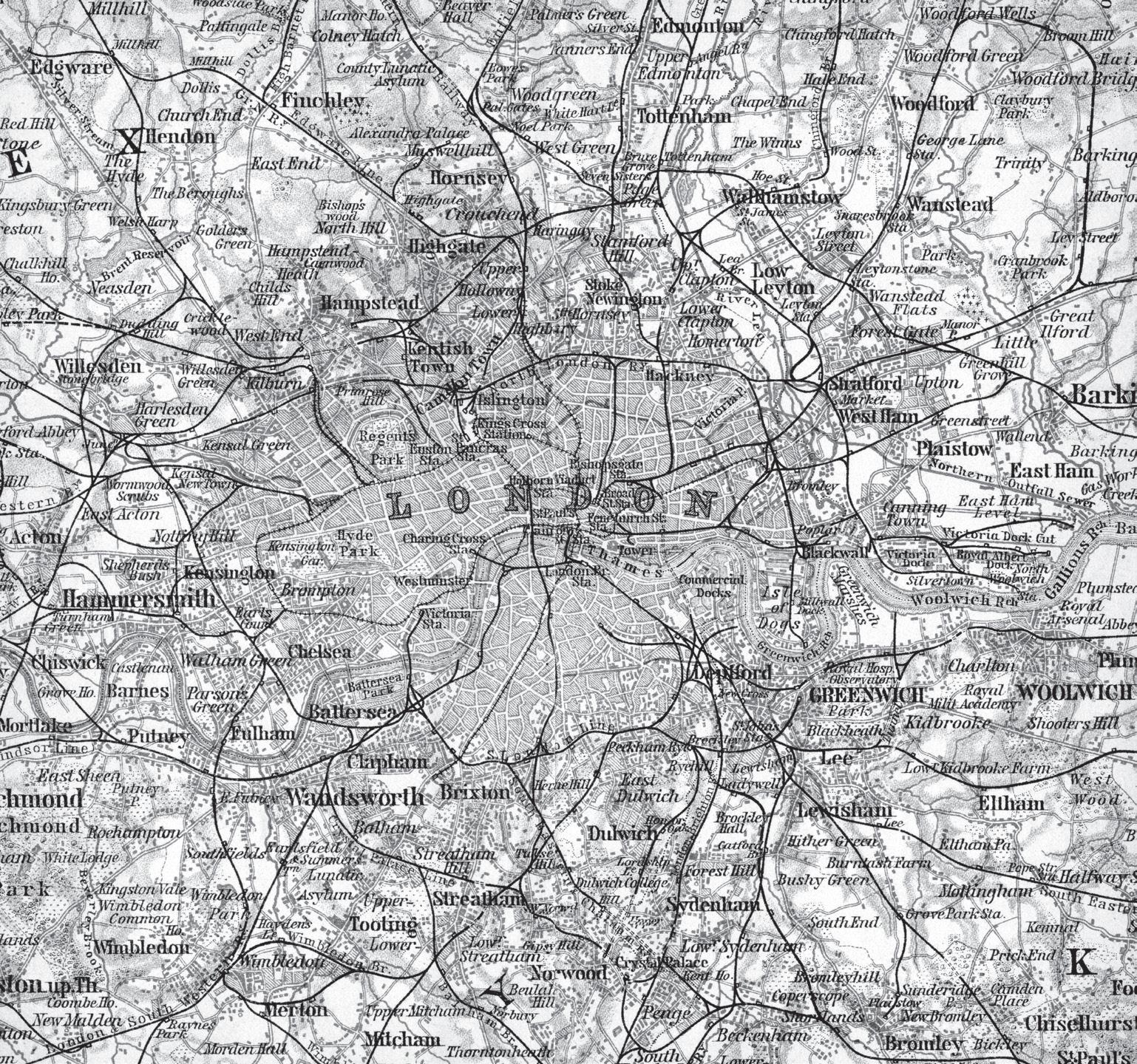
THE railway was the revolutionary invention of the age. For many it marked the true beginning of the nineteenth century. It recast conceptions of time and jettisoned old notions of speed. It did more to unify Great Britain than any political arrangement could have done. Its effects on the growth of new London, and London’s place in the nation, we shall glimpse shortly. But the bullying power of the railway, the rapidity with which it devoured streets and houses to make way for its triumphant iron road and blistering steam, had a transformative effect on old London too, in more ways than one.
The first of the London railways opened close to the heart of the city on 14 December 1836. It ran from its terminus at the south end of London Bridge – the earliest of London’s sixteen railway termini1 –to Greenwich, less than four miles away. At eighteen miles an hour, sometimes over twenty, the journey time was cut from an hour by omnibus or steamboat to some twelve minutes. In its first fifteen months it carried 650,000 passengers, pleasure-seekers mainly for Greenwich’s whitebait dinners and riverside pubs, its fine park and observatory, its uproarious fair.
The line ran on London’s longest viaduct, a giant monument to the bricklayer’s art, which lifted the rails over streets but demolished much poor house property in its way. The arches were let out as workshops and even a chapel and a pub. But untenanted arches had to be shut off to prevent their use for immoral purposes and for hiding the bodies of unwanted babies. The different meanings of railways for London – their
speed, convenience, destructive power, their multi-layered impact on London’s cultural life and social relationships – were all soon apparent from the very first runs on the London and Greenwich Railway around that Christmas of 1836. 2
Much early railway development in London brought travellers merely to the edge of its built-up area, in the new suburbs of the nineteenthcentury city. But a few of the early companies followed the example of the London and Greenwich by driving their lines as close to the centre as property prices and Parliament would allow. These two stumbling blocks went hand in hand. It was very difficult for railway companies to win parliamentary approval to bring lines and stations into wealthy districts, with all their disastrous consequences for property prices. So even the central lines stopped where cheaper property gave way to better.
Property was cheapest south of the river, hence the London Bridge terminus, and on the eastern edge of town, hence the Shoreditch or Bishopsgate terminus of the Eastern Counties (later Great Eastern) Railway, which was opened in July 1840 for trains at first just to Romford but later to East Anglia, and the London and Blackwall Railway to the new East India Docks on the Essex side of the Isle of Dogs. At first the City Corporation had opposed any intrenchment of its ancient boundaries on the grounds that railways would only make street congestion worse, but its position changed and in August 1841 the first permanent City terminus was opened at Fenchurch Street. Dock artisans stood in open ‘stand-ups’, managers and sightseers sat five-abreast in the ‘superior’ class. This line’s arches, by the way, seem to have required the eviction of over 3,000 people through the East End, many from old squalid courts and alleys just north of Rosemary Lane (Royal Mint Street).3
Through the early 1840s and the ‘Railway Mania’ of 1845–7 companies were queueing up in Parliament for permission to build no fewer than nineteen lines in London, each with a new terminus in the City or Westminster. There were so many proposals, threatening to carve up the metropolis like some brick and iron cat’s cradle, that a royal commission was established to consider how best the schemes might be adapted to some rational plan. One option favoured by many was a grand central station to which several companies might run their lines.
The Royal Commission on Metropolis Railway Termini reported in 1846. The intolerable burdens on property, on the people to be evicted
and on those whose businesses would be affected were all spelled out. And so too were the insuperable barriers that viaducts would put in the way of street improvements and traffic flows. So it rejected seventeen of the nineteen planned termini, permitting just two railway extensions south of the river. It rejected, too, any notion of a great shared terminus in central London. On the contrary, it laid down for the north side of the Thames boundaries which railway companies would not be allowed to penetrate. In effect these were the limits of the built-up area as they had applied in 1800: Edgware Road and Park Lane on the west; the New Road, City Road and Finsbury Square on the north; Bishopsgate on the east. South of the river the district to be protected was everything within Borough High Street in the east, Vauxhall Bridge in the west and Kennington Lane in the south.
The royal commission of 1846 snuffed out the 1840s bout of railway mania in London. Relieved of potential competitors, the London and Blackwall Company at Fenchurch Street made the most of its uniquely valuable City asset. In 1849 it connected with the Eastern Counties line and allowed steam trains into the City, replacing the original stationary engines hauling coaches on an endless cable. London Bridge Station had already expanded by allowing new companies and new lines access in 1839, 1841 and again in 1845 and 1850. Also south of the river an important new terminus at Waterloo, on the edge of old London, opened in 1848, having secured permission before the royal commission had reported.4
Railways brought more sweeping changes to the City than blackened arches and smoking engines. Railway mania was a formative factor in the City’s reinvention in the nineteenth century as a specialist financial and commercial district with no room for a resident population. New banks were as common as railway ventures, indeed were often conjoined. Growth in banking was mirrored in the multiplication of insurance companies, the equation between speed and risk representing a minor Victorian neurosis. Share-dealing flourished at almost unprecedented levels during the 1845–7 mania, facilitated by the development of the electric telegraph around the same time. It produced an unprecedented volume of work not just for brokers and jobbers but for printers, engravers, trade and other newspapers, all substantial City enterprises. And railway companies needed headquarters buildings. Prestige, investor confidence and financial networking required many of these to be in the City.
So from around 1840 to 1870 the transformation of the City of London moved at an ever faster pace. The new Royal Exchange (opened in 1844) greatly extended the site where it had burned down in 1838. An unsuccessful share-dealing centre, set up as an alternative to the Stock Exchange, opened as the Hall of Commerce in Threadneedle Street (1844). A new Coal Exchange was built by the City Corporation in Lower Thames Street (1849). The Stock Exchange, owned by a private consortium, was rebuilt and enlarged (1854). The first joint stock bank in the City – the London and Westminster Bank, Lothbury – opened in 1838. By 1847 it had been joined by the London Joint Stock, the Union Bank of London, the London and County, and the Commercial of London; in the 1850s, by the Bank of Australasia, City Bank and more. Both sides of Lombard Street, the old centre of London banking, were virtually rebuilt between 1857 and 1873. The same was true with insurance companies, thirty-two of which were established in London between 1845 and 1851 alone, and another ten set up in the City in the 1850s.
Alongside such specialist institutions as exchanges, banks, insurance companies and discount houses arose the general office block as a speculative venture. From the 1840s buildings entirely to let by the floor or part-floor became common. They were frequently called ‘chambers’, after their early forebears in the Inns of Court. The City Offices Company and the City of London Real Property Company, both especially active in the 1860s, were two among several niche providers of this sort of accommodation. And in and around the offices were anonymous new warehouses for a City that still dealt in real merchandise and not just the paper rights to transfer it from one merchant or banker to another.5
The new City that emerged from the old in these years was a storey or two higher than before and the buildings were more stout and grand, often taking the sites of several houses to make their presence felt. In the basements were strong rooms, the boilers, the clerks’ gloomy lunch rooms; on the ground floor a grand reception area to show a glistering front; on the first a baronial boardroom and offices above; the third floor could be let out to tenants as office space to defray overheads; and a caretaker lived in the attics. Architectural styles were eclectic. Modernity was backward-looking: Italian Renaissance and Gothic were much in favour, with some classical neo-Georgian throwbacks. Ironically, genuinely old buildings were entirely dispensable in the rush
to mock-medievalism. Ironically, too, for a pious age, City churches were complacently sacrificed in the name of Mammon. St Bartholomew Exchange and St Benet Fink went for the new Royal Exchange; St Benet Gracechurch, St Mary Somerset and All Hallows Staining went in the 1860s after the Union of Benefices Act 1860 made more churches redundant; thirteen in all by 1898, several by Sir Christopher Wren among them, most given over to the moneychangers.6
There were other changes too. The old coaching inns that had been such a feature of pre-railway London withered away. In the early years of the century there had been about twenty-five famous houses in the City alone, each with extensive stables and yards and many renowned for their accommodation for travellers. By 1899 all but one in London had gone – the Old Bull in Holborn. Some had been turned into hotels. Some had become carters’ and carriers’ yards. Some, pathetically bowing to the times, combined the business of public house with railway booking office. Most had been demolished for street improvements or for ‘business premises’.7
And then the railway brought traffic. It did so directly, of course, by disgorging people into the City at Fenchurch Street or on its edge in the east at Bishopsgate, and London Bridge in the south. Fenchurch Street passenger traffic doubled to some 3.5 million in 1851 after trains started running there from Islington (via Bow!) the year before. Traffic into London Bridge Station rose from 5.6 million in 1850 to 10.8 million in 1854 and 13.5 million in 1859. An especially troublesome element of this railway traffic in the 1850s and after were through-passengers struggling across the City from London Bridge to, say, Euston, ‘traversing with luggage a great portion of a crowded Metropolis’. 8
Then the railways contributed indirectly as one important factor in enabling people to move away from the City as a residential area. The residential population of the City held up well until 1851. Then it was 128,000, just 400 fewer than in the highest census count in 1801 and 4,300 up on 1841. Indeed, the population density had never been higher: 8.8 persons per house, compared to 7.5 in 1801. 9
But there was a dramatic falling away in the 1850s and even more in the 1860s. The population in 1861 was 113,000, a reduction of 12 per cent. By 1871 it dropped a third in a decade to 76,000. Crowding had reduced too to 8.1 persons per house. In the 1860s, though, this was an exodus less induced by the convenience of suburban travel than by sledgehammer and shovel.10
Those who left, or at least the men and boys among them, usually found themselves part of the army of workers and visitors who travelled daily into the City. Most came on foot – 400,000 every working day, it was said in 1854. A further 54,000 came in by rail, 30,000 by steamers, 88,000 by horse-bus, 52,000 by other vehicles, some 624,000 in all. That was more than if the combined populations of Liverpool and Birmingham had decamped to the square mile and home again each weekday. Every year from then notched up an increase on this already immense volume of people. The number of vehicles entering the City in a twelve-hour period rose by 57 per cent between 1850 and 1865, from 49,000 to 77,000. By 1866 not far short of threequarters of a million (729,000) resorted to the City during twenty-four hours of a working day.11
Traffic in the City’s narrow streets was both interminable and insufferable. ‘Every one feels and deplores the evils of the congestion under which the olden portions of the metropolis – and more especially the City – that great heart and centre of all – suffer,’ complained the Illustrated London News in 1854. It cited Chancery Lane, the main route between Fleet Street and Holborn, yet ‘too narrow at one end to admit of the passage of two vehicles abreast, and where a vast amount of traffic is often brought to a stand-still by a costermonger’s cart, or by a laundress’s wheel-barrow’.12
The City Corporation had not been wholly unmindful of the growing sclerosis in its streets. But hardly any ambitious road scheme had been begun since that great improving decade of the 1820s, apart from Moorgate Street (about 1846) as a connection north from the earlier King William Street. The traffic crisis of the 1850s did, though, prompt some action. Cannon Street was widened from 1854 by the demolition and rebuilding of its south side. And Smithfield Metropolitan Cattle Market was closed in 1855, relocating to a green-field site in west Islington. It removed for ever from London one of its greatest traffic nuisances, vast droves of cattle making their own ‘locks’ every market day, and a unique ‘panorama of cruelty and suffering’, as Dickens called it, after decades of scandal and agitation.13
Most important of all were developments in the Fleet Valley, quite fortuitously a giant leap forward in modernising London. North of Holborn Hill the Fleet remained in parts an open sewer and along its reeking banks lay Field Lane, Saffron Hill, West Street (formerly and notoriously Chick Lane) and innumerable courts and alleys, a ‘solid
mass of misery, of low vice, of filth, fever, and crime’. There had been some piecemeal demolitions and culverting of Fleet Ditch at various times in the 1840s. But in 1855 there was still much pre-Fire property in places like Vine Street, Bear and Staff Yard and even Field Lane itself. The premises of the ‘carrion butchers’ – horse knackers or ‘melters’ –in Sharp’s Alley were said to be home to some of the biggest and fiercest rats in London. A local trade in cats’ skins revealed itself in ‘writhing heaps of cats, literally skinned alive, and occasionally furnishing a living meal to the gaunt swine’ which roamed the alleyways:
wonderful indeed it seems, that wealthy and populous London, with its splendour and resources, should tolerate so detestable a nook on the very confines of its spacious marts; that it should have never a besom to cleanse this foul and festering corner, a breeding place for fevers, cholera, and other more lingering, but equally fatal diseases, that congeal the vital fluids, under a continual access of slow poison.14
Improving this area by extending Farringdon Street northwards began to take shape in the late 1840s. By 1855 the new street, taking property just to the east of Field Lane, had reached Clerkenwell Green, sweeping away Sharp’s Alley with it. From 1856 it inched forward again, reaching King’s Cross Road in 1863. Long before then, the ground on either side of the carriageway had lain barren and unbuilt upon so long it was known as ‘the Farringdon Street wastes’. But the object of the new street – at first called Victoria, later Farringdon, Road – had been as much slum clearance as metropolitan improvement. So rebuilding, as a critic of the City Corporation noted, was of little interest: the poor ‘had been driven away, and what more could be wanted?’15
But the Farringdon Street wastes represented to others a historic opportunity. Since the 1830s the idea of building railways in London underground had been discussed by engineers and entrepreneurs. One impediment, though, had always been an obligation in law to buy any property on the line of a tunnel in case its foundations were undermined. Yet here there was no property left along much of the route. The way had been cleared by the City Corporation.
This opportunity had been identified early on by Charles Pearson, City Corporation solicitor since 1839, and before that an influential radical common councilman. Pearson had been a visionary campaigner
for working-class suburbs connected by rail to London as a cure for central overcrowding. He also kept alive the idea of a central London terminus to bring together in one place the lines of competing railway companies that would otherwise disarrange the centre. In 1851 Pearson proposed a 100-foot-wide road from King’s Cross to Holborn Hill along the line of the Farringdon Street extension, with a tunnel beneath to accommodate eight sets of tracks. Road and tunnel would end, after running under a viaduct carrying Holborn Hill to Newgate, at a grand central station covering six acres on either side of Farringdon Street. It was a stunning vision, some of it twenty years ahead of its time. Pearson, though still a servant of the Corporation – these were libertarian times in matters of conflict of interest – established with some wealthy backers the City Terminus Company in 1852 to prosecute his scheme.
At around this time another company had also identified the potential of the Farringdon Street wastes. The Bayswater, Paddington and Holborn Bridge Railway proposed connecting through an underground railway those new western suburbs with the City at Farringdon Street. The western terminus would be at Paddington Station, first opened in 1838 but to be greatly extended in 1854. They planned to ‘cut and cover’ along the New Road to join Farringdon Road at King’s Cross and then head south. Their surveyor, John Hargrave Stevens, was a colleague of Pearson’s. He was surveyor of the City Corporation’s western division.
This was the scheme which eventually prevailed. Its prime mover and first chairman was William Malins, who had foreseen that without underground railways London’s traffic would render it ‘“almost insupportable for purposes of business, recreation and all ordinary transit from place to place”’.16 Vitally, this underground railway offered the prospect of connecting travellers to London from the Midlands and the north directly with the City at Farringdon Street.
Powers were obtained in 1854 for what was now called the Metropolitan Railway. But the Crimean War constrained the availability of capital and in 1858, without a spade being dug, the company was close to winding up. Pearson came to the rescue. He agitated for the new project so successfully that the City Corporation subscribed for shares worth £200,000. Building began in 1859. It was hampered by technical difficulties even though it relied on cutting a deep trench rather than tunnelling – the foul Fleet burst through the workings in
1862, for example. But all obstacles were eventually overcome and, after four years’ work, the first underground railway in the world opened between Paddington and Farringdon Street on 10 January 1863. That day 50,000 people turned up for a ticket but only half could be accommodated. Despite understandable public prejudice against travelling much of the way in a choking, stinking tunnel – trains were pulled by steam engines intended to be smokeless – it carried an average of 26,000 passengers a day in its first six months. The line was extended to Moorgate in December 1865. 17
The Metropolitan Railway opened at a moment when London and the nation had already entered another railway mania. Through the 1850s new railway developments had stalled while capital was scarce and companies merged and restructured. Yet demand for rail travel continued to grow. New schemes burgeoned in the late 1850s. Victoria Station opened in October 1860, its lines entering from the south and crossing the river on the Grosvenor railway bridge to connect Pimlico with Brighton and Dover. By 1863 London was again the object of railway company attention. Some thirty-three railway and canal bills for new lines and a variety of suburban and central termini were now projected for the metropolis. If they were all sanctioned, a quarter of the City would be laid waste to make way for them. So almost a precise re-run of 1846 faced Parliament in 1863.
The conclusion of a parliamentary committee on Metropolitan Railway Communication was similar to the royal commission’s seventeen years before. It too decided on an overground exclusion zone, but now for a larger London. This time it would extend from Barking in the east, Finsbury Park in the north, Willesden in the west, Brixton and Lewisham in the south. Within this new ring underground railways on the model of the Metropolitan Railway experiment were all that would be permitted.18
But by 1863, when the select committee reported, some schemes had already won parliamentary approval. The City especially was to be invaded more damagingly than ever before, and mainly from the south. Several companies were permitted to follow the Pimlico example and extend the southern network by building new railway bridges across the Thames, planting stations as bridgeheads on the north bank. Thus there was Charing Cross in Westminster, its line over a new Hungerford Bridge opened in January 1864; Ludgate Hill, its over a new and hideous railway bridge at Blackfriars opened in June 1865;
and lines from Waterloo and London Bridge were brought to within a few minutes’ walk of the Bank at Cannon Street in September 1866, over another new bridge. Just one line entered the City from the north–the North London Railway’s extension from Dalston to Broad Street in November 1865. It would soon become one of the most popular short-haul commuter lines in the country. All this involved frantic activity. London was reduced ‘to the condition of a city in a state of siege. It has been invaded on every side by railway directors...’ ‘Railway invasion and compensation cases are the stock subject of the day,’ it was reported in April 1866. 19 With these examples as precedents, the 1863 exclusion zone – and even the City at its very heart –would be penetrated again and again: for yet another GERterminus, at Liverpool Street (February 1874); for a station further into the City for the London, Chatham and Dover Railway (Holborn Viaduct, March 1874); and a third station for the same line at St Paul’s (later Blackfriars Station, May 1886).
These were immensely destructive changes in the City, most of them impacting in the 1860s. They didn’t operate alone. The Corporation of London was never more active than in these very years. It rebuilt Blackfriars Bridge at the same time that it was implementing its most ambitious and costly improvement scheme of the century. This was the construction from 1867 to 1869 of Holborn Viaduct – as Charles Pearson had recommended nearly twenty years before – to carry Holborn Hill to Newgate Street and Cheapside over the Fleet Valley (Farringdon Street). At the west end of the viaduct a traffic nexus was built at Holborn Circus (1872), with new streets to Ludgate Circus and Smithfield, where a modern wholesale meat market was completed in November 1868. The Queen opened both the new bridge and Holborn Viaduct on 6 November 1869, ‘a great day in the annals of the City of London’.20
And approaching from the south-west was yet one more great street improvement. Cutting across New Bridge Street, just north of the new Blackfriars Bridge and heading to the Mansion House, was Queen Victoria Street. It was built as an extension to the new Victoria Embankment and opened in November 1871. It ‘involved the destruction of much valuable property’, costing over £2 million to purchase, one of the most expensive schemes of the century. Queen Victoria Street would install the final spoke in the City’s hub. Seven streets now converged on the great forum fronted on the north by the Bank of