Proceedings from the 2024 annual Meeting of the Society of Wetland Scientists
November 2024 • Taipei, Taiwan
Contributed Session 分組論文發表
Carbon Sequestration of Wetland 濕地碳匯
Assessing the Extent of Restorable Pocosin
Peatlands in the Southeastern USA, with Estimates of Potential CO2 Emission Reductions
評估美國東南部可利用的波科辛泥炭地 的範圍,並估算潛在二氧化碳減排量
Neal Flanagan and Curtis Richardson
Duke University Wetland and Coasts Center
Corresponding author contact: nflanaga@duke.edu
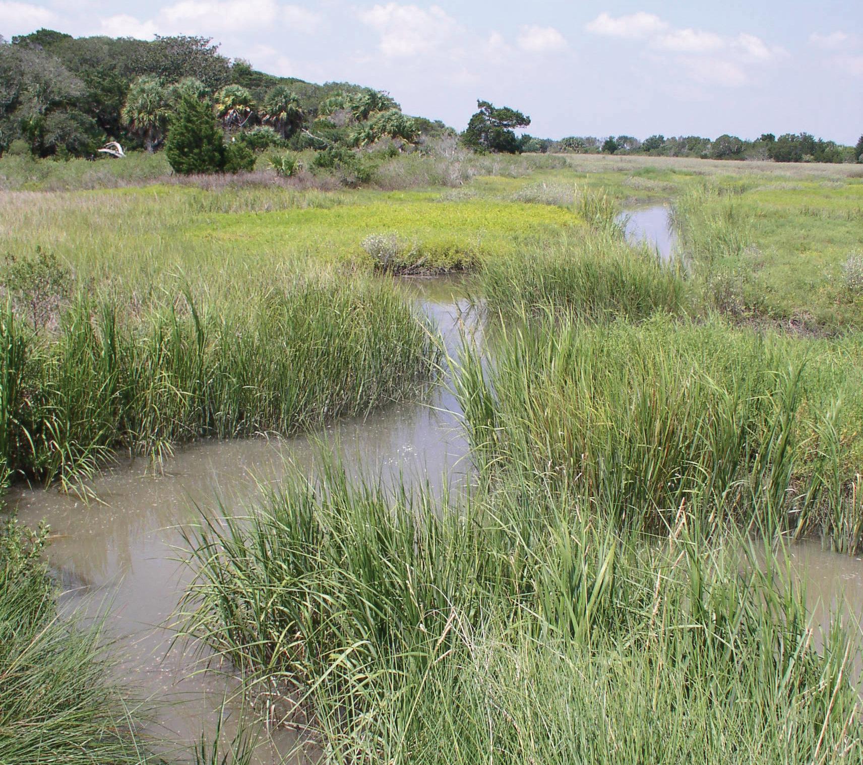
Pocosins are unique peatland ecosystems of the southeastern United States that are major regional carbon sinks and are under threat due to drainage for agriculture and logging, leading to carbon losses from microbial oxidation and fire. This study details an inventory of these peatlands and assesses the potential for rewetting and restoration to halt or reverse these carbon losses. Using existing data sources, the area of restorable peatlands was estimated. We describe the methods of an inventory of the areal extent of Pocosins and similar evergreen tree and shrub-dominated peatlands, using existing data sources such as the Soil Survey Geographic Database (SSURGO) Produced by the United States Natural Resources Conservation Service and Spatial Land Use Datasets such as the U.S. Geological Survey’ (USGS) Multi-Resolution Land Characteristics (MRLC). The area of restorable peatlands (Histosols) along the southeastern coast of the United States was estimated using a state-by-state analysis. Unlike soils with shallow organic layers (such as soils with histic epipedons), Histosols, by definition, have a surface organic layer at least 0.61 m thick; therefore, areas of Histosols having land use consistent with an artificially drained state (agriculture, pasture, or other non-wetlands such as tree farms) were classified as “restorable.” Because a significant reduction in
carbon losses could be achieved by simply rewetting these areas. Histosols without evidence of human alteration were not classified as “restorable” because they appear to be functional peatlands already. Between 45,000 and 76,000 ha. of restorable drained peatlands occur on the coastal plain of the southeastern USA. These are estimated to release an additional 963,000 to 1,627,000 Mg of CO2 annually due to microbial oxidation. Damaging ground fires in unrestored, drained peatlands result in carbon losses of 36.7 Mg CO2 ha-1 yr−1. The annual losses from microbial respiration and fire are as much as 57.9 Mg CO2 ha-1 yr−1, with total annual regional emissions of between 2.6 and 4.4 Tg CO2 yr−1. Up to 127 Tg of CO2 are at risk of loss, assuming the complete loss of the 0.6 m layer of organic matter that defines histosols, with greater possible losses if the average peat depths are greater than 0.6 m. Restoration of Pocosin peatlands covering 0.01% of US land area could contribute up to 2.4% of the annual emission reduction target for the USA.
Contributed Session
分組論文發表
Climate Change Strategies from the Perspective of International Wetlands 從國際濕地的視角看氣候變遷策略
Fostering Environmental Health: From HumanWetland-Connection to Climate-Mitigating Actions among Young People
促進環境健康:從人類與濕地的連結到年 輕人的氣候減緩行動
Sam SS Lau and Angel WL Chui
Hong Kong Baptist University
Corresponding author contact: samlau@hkbu.edu.hk
Climate change continues to pose escalating threats on the environment and human wellbeing. The rapid pace of urbanization and digitalization has diminished opportunities for direct experience with
the natural world, presenting challenges for nurturing environmental concern and climate-mitigating actions, particularly among young people. Extant research suggests nature connection - the emotional attachment to the natural environment - can be a key driver of climate-mitigating actions. However, unlike terrestrial greenspace, studies focusing on wetlands and wetland engagement in association with nature connection and climate-mitigating actions remain scarce. This study adopts an environmental psychology lens to investigate the relationships between exposure and experiences with wetlands, nature connection, and climate-mitigating actions among young people in a highly urbanized city in China. Participants completed a self-reported survey, measuring their exposure to wetlands, nature connectedness, pro-environmental behaviors, and climate change mitigation practices. This study demonstrated the positive effects of wetland exposure and experience on young people’s nature connection and climate-mitigating actions. The study findings illuminate the potential of wetland engagement as a strategy to nurture emotional attachment to nature and promote climate-mitigating actions among young people. This research would inform evidence- based strategies that leverage the potential of wetlands to empower the next generation of climate leaders.
Geospatial Modeling of Ecosystem Services of Ramsar Wetland as Nature-based Solution under Changing Climatic Conditions
拉姆薩濕地生態系統服務的地理空間建
模作為氣候變遷條件下以自然為本的解 方
Shubham Kumar
Central University of Rajasthan
Corresponding author contact: skporia356@gmail.com
In the changing climatic conditions, the role of inland wetlands in semi-arid regions has become more crucial in semi-arid landscapes. These ecosystems provide different vital ecosystem services to humans as well as other floral and faunal species. Still, these ecosystems are facing several anthropogenic and climatic challenges. Therefore, the geospatial modelling of ecosystem services would provide insight into the true potential of these inland wetlands. The current study
evaluates ecosystem services provided by ecologically degraded inland wetlands in semi-arid regions of India. The study adopted the InVEST model for the valuation of ecosystem services using remote sensing and geospatial techniques. The research concluded that these ecosystems are vital for the survival of humans as well as floral and faunal biodiversity. It highlighted the influence of local policy on environmentally responsible management and set a baseline for the vast wetlands networks. The study concluded that inland wetlands play a significant role even after ecological conversion. The areas with high ecological degradation have shown low ecosystem services in terms of water storage, vegetation cover, and carbon storage. These hotspot areas should be prioritized for ecological restoration Several parts of the study area have recovered their ecological disturbances in several parts of being protected areas. This is a positive sign for the study site and an indication of its improving ecological condition.
Contributed Session 分組論文發表
Impact of Climate Change on Marine and Coastal Ecology
氣候變遷對海洋與沿海生態影響
Planning Optimization for Coastal Wetlands under Rising Seas
海平面上升下的沿海濕地規劃優化
Toby Tucker, William Glamore, Alice Harrison, and Bradley Henderson
UNSW Sydney Water Research Laboratory
Corresponding author contact: t.tucker@wrl.unsw.edu.au
Over the course of the next century sea levels will continue to rise under all future projections of climate change. However, coastal wetland habitats like mangroves and saltmarsh are expected to be naturally resilient to rising sea levels. They are able to adapt through lateral migration pathways and have also been shown to vertically accrete. Coastal squeeze has been highlighted as a threat that will limit the adaptability of coastal wetlands. Development of floodplains means that land availability for lateral migration can often be limited. This has other impacts, for example vegetation species such as mangroves can then encroach and outcompete saltmarsh habitat reducing the diversity of coastal wetlands. In addition to floodplain development, coastal squeeze will also be governed by existing
floodplain geomorphology. Coastal wetlands occupying basins with steep banks will be more susceptible to sea level rise compared to wetlands that occupy gradually sloped sections of floodplains. This is because they will only be able to adapt through vertical accretion and not lateral migration. Here, we present a methodology to categorize the susceptibility of coastal wetlands to sea level rise based on their geological setting. Using this categorization, we can also highlight the urgency of coastal wetland restoration. Our research shows that there is a closing window of opportunity for successful natural restoration of mangrove and saltmarsh habitat for many floodplains. We have used hydrodynamic modelling of estuarine water levels to show that as sea level rise occurs, many developed floodplains will become permanently inundated unless strategic action is taken. This work identified a new threat to coastal wetlands caused by inaction – “Passive Squeeze”. By planning and acting now, opportunities exist for coastal wetland restoration and conservation which will not exist in the future.
Coastal Wetlands: Nature’s Defense Against the Impacts of Microplastics and Ocean Warming
on Phytoplankton Biodiversity and Community
Structure
沿海濕地:自然防禦微塑膠和海洋暖化對
浮游植物生物多樣性和群落結構的影響
Abigail Cousins, Nathalie Fenner, Dan Aberg and Christian Dunn
Bangor University
Corresponding author contact: a.cousins@bangor.ac.uk
Phytoplankton are vital for ecosystem functioning and services. They contribute to blue carbon storage via photosynthesis, fixing roughly 50 Gt carbon per annum, and therefore aiding in climate regulation. Phytoplankton are under threat from environmental change including warming and anthropogenic pollution; however, it has been suggested that coastal wetlands can be utilized to help mitigate these effects. While research has focused on ocean warming and eutrophication, less is known on the impacts of microplastics (>5mm) and the synergistic effects of these combined with other stressors on phytoplankton community structure and function. Microplastics are a pervasive pollutant
in coastal wetland ecosystems, with inputs from both land and offshore activities. They are known to have a variety of negative effects on the abundance and biodiversity of phytoplankton found in these environments and elsewhere, such as alterations to gene function and photosynthetic mechanisms. This study aimed to assess the ability of coastal ecosystems to defend vulnerable phytoplankton populations from the persistent impacts of microplastics and ocean warming. Preliminary experimental and observational results have shown potential success. Mesocosm experiments highlighted significant impacts of ocean warming and microplastics on phytoplankton biodiversity (t(15.26) = 3.98, p = 0.001) and community composition (V = 74.5, p = 0.006). The addition of seagrass was found to mitigate these negative impacts, as no significance was found between the changes in biomass of the control and treated samples (F(1)= 0.356, p > 0.5). Further, there has been success using experimental seagrass beds for the filtration and sedimentation of microplastics, highlighting the potential mitigation mechanisms for anthropogenic pollution. We assessed the presence and characteristics of microplastic pollution in seagrass, saltmarsh, and mangrove substrate, utilizing a density separation method. Comparing the effectiveness of the different coastal wetlands to store microplastic pollution and remove it from the coastal aquatic ecosystem, with significance being identified between the locations of sampling within environments. Continuing studies are needed but these results present a positive way forward to potentially combat the intensifying problem of phytoplankton loss and subsequent reduced carbon sequestration due to changing climate and anthropogenic pollution.
High Frequency Air-Water CO2 Fluxes in a Saltmarsh
Tidal Creek and Implications for the Coastal Carbon Budget
鹽沼潮汐溪中的高頻空氣-水二氧化碳通
量及其對沿海碳預算的影響
Songjie He,1 Kanchan Maiti,1 Christopher M. Swarzenski,2 Scott V. Mize,2 and Camille L. Stagg3
1Department of Oceanography and Coastal Sciences, Louisiana State University, Baton Rouge, LA, USA 2U.S. Geological Survey, Lower Mississippi-Gulf Water Science Center, Baton Rouge, LA, USA 3U.S. Geological Survey, Wetland and Aquatic Research Center, Lafayette, LA, USA Corresponding author contact: she5@lsu.edu
Tidal salt marsh soils sequester organic carbon at rates higher than most ecosystems in the world. This represents a major component of the coastal “blue carbon” ecosystem service. Thus, it is important to assess the pathway by which carbon stored in salt marshes can be released. Previous studies have indicated that considerable amounts of dissolved organic carbon and dissolved inorganic carbon (DIC) can be exported laterally from salt marshes to adjacent surface waters through tidal exchange, although the exact magnitude of such loss is currently unknown. Such estimates are difficult in part because a large portion of the DIC transported from marsh to adjacent water bodies can also be quickly degassed to the atmosphere via air-water CO2 exchange. The magnitude of CO2 degassing in the tidal water adjacent to coastal salt marshes is thought to be high due to DIC enriched porewater exchange but currently not well studied. Louisiana salt marsh porewater has one of the highest reported DIC concentrations, as high as 32 mmol/kg, making it an important location to such CO2 outgassing. In this study, we conducted high frequency pCO2 measurements in a tidal creek of a salt marsh in coastal Louisiana. We deployed dissolved pCO2 sensors in the tidal creek at our study site to record high frequency variability in dissolved pCO2 for periods ranging from 2 to 38 days. Between January 2021 and July 2022, dissolved pCO2 concentrations varied from 120 µatm to over 20,000 µatm. Preliminary results show that air-water CO2 fluxes are highly correlated with creek water level and passages of cold fronts. Comparisons between the air-water CO2 fluxes and the CO2 emissions measured by an eddy covariance tower on the same
marsh will also be evaluated to improve our current understanding of marsh-sourced CO2 degassing in tidal waters and its impact on coastal carbon budget.
The Carbon Budget of Lumnitzera racemosa
Mangroves in Taiwan
臺南七股濕地紅樹林的碳預算
Tzu-Chieh Chiu,1 Chen-Ying Ko,1 Chien-Wei Huang,2 WeiJen Lin,1 Hsin-Hsun Wu,1 Hsing-Juh Lin,2 and Chiao-Wen Lin1
1National Sun Yat-sen University, Taiwan 2National Chung Hsing University, Taiwan
Corresponding author contact: cwlin@g-mail.nsysu.edu.tw
Mangroves provide numerous ecosystem services and possess a high ability for carbon sequestration, making them a natural-based solution for mitigating climate change. Unlike most mangroves, Lumnitzera racemosa (L. racemosa) mangroves can grow in coastal and terrestrial environments. However, research on the carbon sequestration of L. racemosa mangroves is still unclear. To complement the baseline data of mangrove carbon budgets in Taiwan, this study quantified the net primary production, litterfall decomposition, soil greenhouse gas (GHG) emissions, and carbon storage in L. racemosa mangroves in Taiwan in 2023. This study established the carbon budgets of the L. racemosa mangroves. The results showed that the range of GHG emissions from the soil of L. racemosa mangroves across five seasons: CO2: 9.66~45.05 g CO2 m-2 d-1, CH4: 3.45~44.47 mg CH4 m-2 d-1, N2O: -0.08~3.86 mg N2O m-2 d-1. The carbon sequestration rate varied between seasons: 5.41 Mg C ha-1 season-1 from winter to spring, 1.12 Mg C ha-1 season-1 from spring to summer, 5.99 Mg C ha-1 season-1 from summer to fall, and -5.50 Mg C ha-1 season-1 from fall to winter, and the annual value 7.01 Mg C ha-1 yr-1.The results indicate that mangroves are a carbon sink ecosystem, primarily driven by variations in plant biomass and soil carbon storage. The year-long survey of carbon budgets has been completed. This study is expected to be applied to mangrove management and carbon reduction policy.
Contributed Session 分組論文發表
In Practice of Satoyama and Satoumi and Biodiversity Impacts 里山和里海的實踐與生物多樣性影響
A Little Bit More of Space and Love: The Importance of Riparian Zone to A Critical Endangered Species, Squalidus Iijimae, and How We Can Help Its Population
多一點空間與愛:河岸帶對瀕危物種飯島 鮈魚的重要性,以及我們可以如何幫助其 族群成長
Chi-Chang Liu, Wei-Che Chang, Lee-Chih Sheu, and NaiYun Chang
National Taiwan University (for senior author) Corresponding author contact: chichangliu@ntu.edu.tw
In order to conserve biodiversity of Taiwan, the Forestry and Nature Conservation Agency started conservational acts for 22 critical endangered species. Among these, Squalidus iijimae was documented with its limited distribution in only two rivers and the population was declining rapidly. In order to strategize conservational efforts, more information about its current status, habitat preference and reproduction needs to be clarified. We have been conducting survey on S. iijimae since 2022, not only in its natural habitats, but also on one translocated population in central Taiwan. In Toucian River and Houlong River, we used a mixed method combining hook- and- line fishing, cages with baits and skin diving fish counting to document the population dynamics per season, and recorded habitat parameters such as river width, depth, flow velocity, substrate composition and water chemistry. In its translocated population, we used hook- and- line fishing to collect samples and documented body length and weight, gonad weight, maturing status of gonads and eggs counts biweekly. We conducted surveys at 53 sampling sites along the two rivers and found S. iijimae in 17 sites among those. This species is mainly found in Houlong River and its tributaries such as Shahe, Yanshueikeng and Nanhue Creeks, though no fish was found in Toucian River in our survey. We also documented seasonal change of S. iijimae population, possibly due to low water temperature and flood. We found S. iijimae prefers low velocity (close to 0 m/s), deep (78-250 cm) and mainly sandy substrate habitats
together with healthy and rich riparian vegetation. We also found that high ground subsidence might block their way home after washed downstream by a flood. The results of our reproductive study on the translocated population showed an asynchronous reproductive pattern, reproducing multiple clutches of eggs during the spawning season from March to September. Egg counts of S. iijimae ranged from 5, 438 to 6,326. In conclusion, S. iijimae is a species with high fecundity and middle water chemistry tolerance. The threats they are facing should mostly be habitat loss and fragmentation due to urban development and inappropriate river/ flood management which pay very little attention on biodiversity and ecosystem. We suggested that when undertaking such projects, habitats such as braided channel and riparian zone should be considered to be maintained or created for the survival of aquatic lives such as S. iijimae.
Implementation of the Satoyama Initiative and Biodiversity Conservation in Torik Tribe, Taitung County, Taiwan
臺東都歷部落實踐里山倡議與生物多樣
Hui-chun Hsu, Su-Fen Tsai, Meng-Yi Lin, and Chang-Yu Wu
Taitung Branch, Forestry and Nature Conservation Agency, Ministry of Agriculture
Corresponding author contact: thiou1018@gmail.com
This area is a key promotion zone within the conservation axis of the Duoliu River, situated in the southern section of the Coastal Mountain Range, part of the Taiwan Ecological Network (TEN) within Taitung County Since 2003, the Torik Tribe has participated in the Community Forestry Program of the Forestry and Nature Conservation Agency (FANCA), conducting patrols and ecological monitoring and surveys in the forest, river, fields and sea areas surrounding the tribe. Their efforts have created an ecologically friendly production landscape that balances ecology and livelihoods. Through the comprehensive framework of the Satoyama Initiative’s “Vision-Method-Action Strategy” three-fold approach, action strategies and plans have been developed under the TEN program. These include ensuring the reasonable use of natural
resources and environmental carrying capacity and climate-adaptive agricultural production. Through resilience assessment workshops (RAWs), adaptive collaborative management (ACM) is integrated into TEN. This involves developing a community-based governance mechanism for the socio-ecological production landscapes and seascapes (SEPLS) of the Torik tribe. Tribe members have continually participated in TEN conducting surveys that have revealed a highly diverse range of biodiversity within the area. This includes 490 plant species from 112 families, 333 species of terrestrial and stream wildlife from 101 families across 27 orders, 136 species of intertidal invertebrates from 57 families across 7 orders. In the process of practicing the Satoyama Initiative, the Torik Tribe has implemented 11 of the United Nations Sustainable Development Goals (SDGs) and addressed 3 goals of the Kunming- Montreal Global Biodiversity Framework. These include Action Target 8 - the concept of NbS has been introduced to the vertical corridor of the River revitalizing the stream’s ecosystem alongside local tribal efforts; Action Target 9 - sustainable use of wild species involving ecological surveys across stateowned forest lands and traditional maritime areas to preserve biodiversity; and Action Target 22 - integrating the ACM process through RAWs. These discussions led to the establishment of a comprehensive governance mechanism for forest and sea areas within the community-based collaborative governance framework. Based on the existing promotion of community forestry and the Satoyama Initiative, the Taitung Branch of FANCA and the Torik Tribe are incorporating the significant meanings and goals of embedding and enhancing biodiversity. This effort aims to preserve the resilience of ecosystem services in SEPLS while balancing the transmission of indigenous local knowledge, and environmentally friendly. The goal is to improve the local people’s sustainable use of their local ecosystem.
Wetland Conservation and Artistic Creation: Creative Arts in Landscapes and Seascapes of Taiwan’s East Coast, Hualien County, Fengbin Township
濕地保育與藝術創生-以花蓮縣豐濱鄉 森川里海藝術行動為例
Chen Meiyin1 and Su Ssu-Ming2
1Forestry and Nature Conservation Agency, Hualien Branch 2Node Creative Ltd. Co.
Corresponding author contact: piceawind@gmail.com
Fengbin Township is located in Hualien County, along the Pacific Ocean within the Xiuguluan River and the Northern Section of the Coastal Mountain Range conservation corridors of Taiwan Ecological Network. This artistic action project is meant to preserve traditional skills and promote an innovative use of affluent landscapes and seascapes of eastern coastal Taiwan, to create diverse and resilient communities and improve local livelihoods. The Forestry and Nature Conservation Agency, Hualien Branch held the Mipaliw Wetland Art Festival in Fengbin since 2017 and started place-making artistic action plan in area of 6 tribes from 2019 to 2023. Thirty-seven elders were interviewed to support documentation of the 67 natural materials and revitalization of 23 handicraft skills. A total of 40 artists practiced all forms of creative actions. Together with the local people, they completed 5 material distribution maps, 4 picture books in Indigenous languages, 2 nature resource application illustrations, 4 animations, 15 folk songs, 5 innovative products, and 5 experience tours. Art action here serves as a medium for tribal production, ecological restoration and promotion of life and cultural values. It brings a large number of tourists and creates additional income during the art the Mipaliw Wetland Art Festival. This study uses the action research method as a social inquiry model where the actor is the researcher. Indigenous locals were interviewed about the social-cultural significance of natural materials, on site visits and skill demonstrations were conducted, both the memory and the practical skills were documented. At the same time, artists were invited to use the data to conduct field studies, material experiments and create wetland landscape art works to share the results of their work with the tribal communities, especially young people. The empirical
evidence is supported by integrating both local and external creator’s professional knowledge and skills. As a result of this research, the local residents’ have been encouraged to support wetland conservation. They have led to restoration of wetland plants such as Arundo coleotricha Honda for ceremonial use, Short leaf Galingale and Umbrella Plant for weaving, Wrinkled Marshweed for rice wine koji, and Silver Grass for construction purposes – a species that is now rapidly disappearing in Fengbin area. This project has helped many wetland plants to be rediscovered and rejuvenated. The wetland area is now being restored and managed for species conservation and public education, covering a wide diversity of ecosystems from paddy terraces to the coast, where Giant Clam is being conserved by the local people, shows the efficacy of artistic actions in raising wetland conservation awareness.
Conservation of the Pheasant-tailed Jacana and Promotion of Eco- Friendly Farming Practices: A Case Study of the Pheasant-tailed Jacana of Guantian, Tainan
水雉保育與友善耕作推廣-以臺南官田水 雉為例
Chang-Hsin Wang, Wen-Chen Lee, Yu-Ching Hsu, and Tai Chang
Chiayi Branch, Forestry and Nature Conservation Agency, Ministry of Agriculture (for senior author)
Corresponding author contact: wangphilipstar@gmail.com
The Pheasant-tailed Jacana (Hydrophasianus chirurgus) is declared to be a precious and rare species of wild animal by the Ministry of Agriculture and is also the city bird of Tainan. Pheasant- tailed jacanas prefer to inhabit wetland environments with floatingleaved aquatic plants. In Tainan’s Guantian area, they primarily settle in fields of water chestnuts. In recent years, the Chiayi Branch, Forestry and Nature Conservation Agency (FANCA) has been promoting Taiwan Ecological Network (TEN), having designated the Southern Jiannan Plain Wetland conservation corridor, with the Pheasant-tailed Jacana Conservation Park (PTJCP) and Hulupi Nature Park as the core, connecting surrounding paddy fields, irrigation channels, and pond water areas, establishing friendly
habitats for jacanas and cohabiting species of concern. FANCA in collaboration with Tainan City Government, encourages farmers to participate in jacana conservation through the payments for ecosystem services (PES), including incentives for breeding notifications and habitat creation, enabling community farmers to collectively safeguard wildlife habitats and improve local ecological environments. In Guantian, agricultural land is primarily used for the rotation of water chestnuts and rice. In earlier years, to protect crop yields from wildlife predators, conventional farming methods involving the use of pesticides or insecticides were employed, posing threats to jacana and other wetland organisms. In response to pesticide poisoning incidents, since 2010 FANCA has been working with PTJCP to extend conservation efforts to neighboring communities and schools. Through advocacy seminars, community farmers and students raised their awareness of ecofriendly farming and jacana conservation. Gradually, farmers were guided towards environmentally friendly farming practices with funding support from FANCA, along with certification assistance from Tse-Xin Organic Agriculture Foundation to promote the Green Conservation Label. Due to the challenging nature of promoting water chestnut consumption, collaboration with PX Mart was initiated in 2021, marketing nationwide through fresh and ready-to-eat water chestnuts, encouraging consumers to support jacanafriendly water chestnuts and eco-friendly farming. Currently, there are seven farmers under this brand, who have in total cultivated 4.8 hectares of four-angled water chestnuts and over 0.6 hectares of two-angled water chestnuts. After years of joint efforts, the jacana population of Tainan region has repeatedly reached new heights, with a count of 2,882 in winter of 2023. The Chiayi Branch, FANCA and the PTJCP continue to foster cooperation in jacana ecological conservation across different sectors through TEN aiming to create a harmonious coexistence between people and nature.
Effects of Sluice Gate Operations on Environmental Factors and Benthic Macroinvertebrates in Cih Lake, Kinmen
閘門運作對金門慈湖環境因子及底棲大 型無脊椎動物的影響
Sing-Pei Yu and Ching-Ren Kang
Diversity Ecological Consultant Co., Ltd.
Corresponding author contact: kangchingren@gmail.com
Cih Lake is an important habitat for many aquatic organisms in Kinmen. After the dike construction in 1969, Cih Lake became a closed reservoir and relied on the sluice gates to have water exchange. Due to the poor water exchange rate, the water quality inside Cih Lake drastically deteriorated. As a result, in 2017, Kinmen National Park Headquarters started to operate the sluice gates in order to increase seawater exchange in Cih Lake. In this study, an experiment is designed and executed near Cih Lake sluice gate. Three sluice operation scenarios were executed: the present operation mode of Kinmen National Park Headquarters (no extra water exchange, control operation) and two additions of water exchange treatments (once and twice every month, respectively). To determine the impact of addition water exchange, water quality, sediment properties, and benthic invertebrates were assessed at the end of each operation scenario. We compared these parameters between control and water exchange treatments to quantify the function of water exchange. The results showed that additional water exchange decreased nutrient concentrations. For sediments, the effect of additional water change was not significant. The abundance of crustacean seemed to increase after additional water change, while gastropods did not. The abundance of polychaetes only increased when two additional water changes were applied. In conclusion, we recommended that additional water exchanges be conducted once to twice every month. This could improve water quality and increase of crustacean and polychaete abundance in Cih Lake.
A New Carbon Sinks and Biodiversity-weighted Model - A Case Study on the Coastal Wetlands of Southwest Taiwan
盤點新增碳匯及碳權,包含生物多樣性— 以臺南市3處濕地為例
Yih-Tsong Ueng,1 Feng-Jiau Lin,2 Ya-wen Hsiao,3 and Perng-Sheng Chen4
1Department of Environmental Engineering, Kun-Shan University, 195, Kunda Road, Tainan 710, Taiwan 2Tainan Hydraulics Laboratory, National Cheng Kung University, 500, Sec.3, Anming Road, Tainan 709, Taiwan 3National Land Management Agency, Ministry of the Interior, 342, Sec. 2, Bade Road, Taipei 105, Taiwan 4 Marine National Park Headquarters, National Park Service, Ministry of the Interior, 26, Demin Road, Kaohsiung 811, Taiwan Corresponding author contact: cbs59@nps.gov.tw
This paper presents a bio-carbon sink calculation method that incorporates biodiversity and demonstrates its feasibility in the coastal wetlands within Tainan City. The wetland profiles adopted for this method include information about local mangroves such as Avicennia marina, Lumnitzera racemose, Rhizophora stylosa, Kandelia obovat, and Excoecaria formosan, respectively. Furthermore, these wetlands, mangroves, windbreak forests, and biodiversity habitats collectively cover an area of 7,789 ha, 202 ha, 240 ha and 1447 ha, and had carbon storage 581,820 tons, 53,222 tons, 92,794 tons and 67,159 tons, respectively. This adjustment would enhance the carbon sink biodiversityweighted increasing approximately 9.2% of the original carbon sink. The approach highlights the importance of considering biodiversity in carbon sink initiatives.
Public-Private Partnership and Integration of Competent Authorities to Promote Land Crab Conservation in Gaomei Wetland
公私合作、主管機關整合推動高美濕地陸 蟹保護
Ya Ching Hsu, Tsai, Jyuan-Ru, Hsingyu, Hung, and Chang Hungyi
Taichung Branch, Forestry and Nature Conservation Agency (for senior author)
Corresponding author contact: jrtsai.bio@gmail.com
Land crab activities in coastal forests can accelerate the decomposition of fallen leaves, circulate gasses in the soil, and create carbon-rich soil microhabitats. Further, they promote the growth and development of coastal forest physiognomy. However, human activities have been causing the threats in land crab population. The surrounding areas of Gaomei Wetland have high complexity of land ownership. The conservation of the land crab resources needs public-private collaboration and integration of competent authorities through the Taiwan Ecological Network (TEN).
The roadkill survey of the land crab in Gaomei Wetland. The Department of Life Sciences of Tunghai University and the Third River Management Branch of Water Resource Agency formed a team to conduct a roadkill survey of land crabs in Gaomei Wetland in 2016 and 2017. They established a database of land crab distribution, habitat preference and the roadkill hotspots in the Gaomei Wetland.
Public-private Partnership between authorities and local NGOs. Gaomei Wetland land crab patrol protection program began in 2018. The Wild Bird Association of Taiwan helped the Authority to perform night patrols. The aims of this program were to release the ovigerous female crabs to the seashore and to avoid the catching behaviors by humans. In 2022, the Gaubei Community Development Association joined the patrol duties and expanded the patrol area to coastal windbreaks.
Discussions on division of labor of land crab conservation through TEN. Taichung Branch of the Forestry and Nature Conservation Agency (FANCA) promotes the TEN program to analyze habitat landscape, species of concern, ecological information,
and further deduce five conservation corridors with linkage benefits. Among them, the plight of land crabs in Gaomei wetland is an important issue of concern for the Taichung Coastal Wetland conservation corridor.
The effectiveness of mitigations for artificial structures in reducing roadkill of land crabs. TEN meeting prompted the Third River Management Branch of the Water Resource Agency to initiate a pilot test on the use of friendly seawalls in 2023. A total number of 43 slope improvements replace the vertical seawall at appropriate intervals. This improvement facilitated the climbing efficiency of land crabs.
Collaborations among authorities and local NGOs have provides the basic information and basic information of the land crabs. Environmental education, consultation and guidance of the land crabs were brought in by the NGOs and have been drawing the attention of local people. There is still a need to strengthen the cooperation between the public and private sectors to create a land-crab- friendly environment in Gaomei Wetland and its surrounding area.
Contributed Session 分組論文發表
National Policies of Wetlands & International Perspectives on Wetlands 國家濕地政策與國際濕地觀點
Casting the first BRICS: Towards an interpretation of the Ramsar Convention favouring Citizen Science in the Multilateral Environmental Agreement for wetland management
鑄造第一個金磚國家:在濕地管理多邊環 境協議中對拉姆薩爾公約的解釋有利於 公民科學
Bramley Lemine and Mahabubur Chowdhury Cape Peninsula University of Technology Corresponding author contact: bramley001@gmail.com BRICS has agreed to focus on promoting wetland protection, restoration and wise use in its multilateral environmental agreement (MEA) under its agenda of “Advancing environmental cooperation amongst BRICS towards the attainment of the 2030 Agenda for Sustainable Development”. This published paper advanced an argument that the MEA must incorporate measures of citizen science (CS) to attain the agenda’s
aspirations and comply with the Ramsar Convention, specifically with a view on wetland management and the law. There is no express provision or obligation to exercise or consider CS in the wording of the Ramsar Convention. To prevent a blanket statement of “no express provision”, Article 31 of the Vienna Convention on the Law of Treaties 1969 (VC) makes provision for the “Interpretation of Treaties”. The interpretative measures include, among others, “object and purpose”, “any agreement relating to the treaty”, and “any rules of international law”. Therefore, to prove the hypothesis, this contribution applies Article 31 of the VC provisions to show that (1) there is an integral relationship between CS and wetland protection; (2) that the “object and purpose” of the Ramsar Convention promotes CS; (3) there is evidence of CS in terms of “any agreement relating to the treaty”; and that (4) the “any rules of international law” relative to the Ramsar Convention is geared towards CS. The findings show sufficient evidence that the Ramsar Convention supports an interpretation in favor of CS, albeit old (1971) in vintage. New MEAs, this one by BRICS, create the opportunity for rejuvenating these MEAs by including factors such as CS to establish legal certainty.
The Wise-Use Checklist as a Science–Policy Interface – the Interaction of Science and Policy in Taiwanese Wetland Conservation Policy
明智利用作為科學與政策的介面-臺灣 濕地保育政策中科學與政策的互動
Chen-Guang Lee
National Taiwan University
Corresponding author contact: cglee.work@gmail.com
The ‘Wise-Use Checklist’ was designed to assist participants in formulating the ‘Conservation–Utilisation Plans for Wetlands of Importance’ in Taiwanese wetland conservation policy programme. Feedback from the planning teams, however, indicated that the checklist was difficult to use. Therefore, this research employed the perspective of science–policy interfaces to understand the barriers people were experiencing while implementing the checklist and identify the factors influencing the governance between science and policy in wetland conservation.
The study mainly focused on the period from 2013 to 2015, when the wetland conservation policy was transformed into legislation and regulations in Taiwan. Semi-structured interviews were used to understand the thoughts of planners who participated in the formulation of the ‘Conservation– Utilisation Plans for Wetlands of Importance’.
The interviews revealed that the main barrier to the planners was the uncertainty produced by perception divergence, technical difficulties, and policy–institutional barriers, rather than the checklist itself. The responses identified tensions and governance issues among the scientists and between the scientists and policymakers with respect to wetland conservation policies. The research revealed the importance of interactions and offered six areas for discussion in the aspect of governance between wetland scientists and policymakers.
Integrating the Priorities for Asian Wetlands
within the 5th Strategic Plan of the Convention on Wetlands (‘Ramsar’ Convention)
將亞洲濕地的優先事項納入《濕地公約》 的 5項策略計劃
Robert McInnes,1 Nicholas Davidson,2 Priyanie Amerasinghe,3 Matthew Simpson,4 Rebecca Woodward,4 Christine Prietto,5 Luisa Ricaurte,6 and Sana Mezoughi6 1 RM Wetlands & Environment Ltd, 2Nick Davidson Environmental, 3International Water Management Institute, 435percent 5Hunter Wetlands Centre Australia, 6Independent Corresponding author contact: rob@rmwe.co.uk
In July 2025, the intergovernmental Convention on Wetlands (known as the ‘Ramsar’ Convention) will adopt its 5th Strategic Plan at the 15th Conference of the Parties (COP15) in Zimbabwe. Since COP14 in 2022, the Convention has been developing the content and structure of this Plan. The authors of this presentation have been working on behalf of the Convention to develop and synthesize the evidencebase for the development of the 5th Strategic Plan. A key aspect of the work has been to evaluate the state of wetlands in different regions across the globe, to assess the main threats and to propose solutions and actions that will stem wetland degradation and
loss. The process has involved conducting a robust literature review of the scientific evidence to understand the range and magnitude of the different direct and indirect drivers of wetland threats. Recurring issues are reported from across the world. In Asia threats from inter alia agriculture, land use change, urbanization and hydropower were all highlighted as being significant at a range of levels from the regional to the national. An extensive consultation program with key stakeholders and partners was conducted to understand priorities, opportunities and capabilities. Consultation approaches included a global online questionnaire survey, twenty-five virtual workshops involving a range of stakeholders and partners including inter alia from national governments, local governments, Ramsar Regional Initiatives and Centers, NGOs, Civil Society Organizations, academics and consultants, and a variety of other informal engagement opportunities at wetlandrelated meetings. The results of the consultation process demonstrated differences in both the challenges wetlands face and the proposed solutions from region to region and also in countries of different levels of economic development. In Asia, the main negative drivers of wetland state reported were urban-industrial pollution, climate change and invasive species. The most frequently reported solutions for addressing wetland threats in Asia were raising community awareness, direct conservation management measures, designating protected areas, environmental education and demonstrating the importance of wetlands to human society. This presentation will present the main findings from the literature review and consultation process, and highlight the particular challenges faced by Asian wetlands. An update on the overall status of the 5th Strategic Plan shall also be provided to set Asian wetlands within the global context of the Convention.
The Emergence and Evolution of Carbon Sink Policies in South Korea: From Green Carbon to Blue Carbon
韓國碳匯政策的產生與演變:從綠碳到藍 碳
Sohui Jeon
University of New South Wales
Corresponding author contact: sohui.jeon@unsw.edu.au
This study investigates the emergence and evolution of carbon sink policies in South Korea (hereafter Korea), with a particular focus on examining the state’s capacity to successfully integrate and advance twin economic and environmental goals in two key initiatives: green carbon and blue carbon. It tests the proposition that the state’s capacity to promote transformative developmental- environmental goals in natural resource governance areas hinges on the state’s willingness and ability to establish relationships with a much broader and more diverse range of actors compared to traditional manufacturing industries. Therefore, the study aims to analyze the patterns of cooperation and conflict in Korea and various domestic constituencies in the developmental policymaking process, which is crucial for understanding the state’s ability to realize its transformative visions through the carbon sink. The methodology employed in this study combines document analysis and process tracing to investigate the emergence and evolution of carbon sink policies in Korea. While tracing, documenting, and explaining policy change is the primary focus, institutional changes play a crucial role in facilitating or constraining these policy shifts. The results of the study indicate that the political elite’s emphasis on developmental environmentalism has led to a focus on forests and wetlands as carbon sinks. Regarding green carbon, this has strengthened the relationship between business and the state through carbon offset and emissions trading systems. Government initiatives, such as the Forestry Direct Payment System, have facilitated the participation of foresters in green carbon policy development. Additionally, the conflicts between the state and environmental NGOs over establishing a sustainable cycle in forest resources management challenge the traditional top-down approach. For blue carbon, recent initiatives aim to absorb carbon through strategies outlined in the Carbon Neutral Roadmap
for the Maritime and Fisheries Sector. While still in the early stages, blue carbon initiatives show promise, particularly through proactive collaboration with relevant businesses. However, further collaboration and a specific institutional framework are needed to develop blue carbon strategies fully. Overall, this study highlights the necessity of creating a robust institutional structure involving a diverse range of actors for longterm success in carbon sink policies and environmental sustainability.
Wetlands in South Africa: Domestic Environmental Laws and Climate Resilience
Clarice Arendse
Richard Summers Inc.
Corresponding author contact: clarice@summersinc.co.za
South African wetlands are under significant threat as increased temperatures leads to the drying up of wetlands, which in turn results in higher water abstraction rates, which may invariably result in the reduction and ultimate depletion of wetlands. This is compounded by development pressures along and within waterbodies due to the shifting of the high-water mark and urban sprawl. To accommodate development, various legislation has been adopted to aid responsible and sustainable development. The overarching national environmental framework law, the National Environmental Management Act provides that sensitive, vulnerable, highly dynamic or stressed ecosystems … wetlands … require specific attention in administrative, management and planning procedures, especially where they are subject to significant human resource usage and development pressure. To combat South Africa’s vulnerability to climate change, the country has embarked on a legislative process aimed at coordinating and integrating a response to climate change as well as managing climate change impacts by enhancing adaptive capacity, strengthening resilience and reducing vulnerability to climate change through the introduction of the Climate Change Bill (2022) (“CCB”).Objectives are: 1) to ascertain whether the CCB in its current state effectively promotes wetland protection as posited in domestic environmental laws, and 2) to ascertain
whether the CCB allows for coherent decision-making in stressed environments.
This research follows a qualitative approach, and the techniques are doctrinal legal analysis, documentary analysis and content analysis. The findings indicate that domestic environmental laws have to an extent, accommodated climate change impacts. The net effect of the CCB is to introduce mechanisms to aid in managing and implementing the required climate change response through the use of the best available science, evidence and information. However, South Africa’s domestic environmental laws are inadequate in effectively predicting adverse effects associated with climate change. On the face of it, the CCB seeks to harmonize competing interests such as climate change impacts and development pressures through an integrated approach to decision-making. From a bird’s view, it appears that the CCB is an adequate statutory response to releasing or mitigating the stress on wetlands. However, other barriers which preclude effective implementation may stifle the realization of the fullest potential of the objectives of the CCB.
The Integral Role of The Wetland Ecologist In Mine Planning
濕地生態學家在礦山規劃中的整體作用
Kathy Taggart
Jones & Wagener (Pty) Ltd Engineering & Environmental Consultants
Corresponding author contact: kathy@jaws.co.za
Africa houses roughly thirty percent of the known global mineral reserves, making its mining industry one of the most important in the world. These sought-after commodities have been extracted, and often exploited, for centuries. Wetlands, by virtue of their positions in the landscape, are frequently impacted by these mining activities, both directly and indirectly. These impacts are ongoing for the foreseeable future as minerals will continue to be mined to support the natural resourcebased livelihoods that are prevalent within Africa. This makes the protection and conservation of wetlands and the maintenance of the services that they provide fundamental to sustainable development within these countries.
This presentation provides insights, as to how the involvement of the wetland ecologist, together with an integrated team of specialists, has allowed for the sustainability of wetlands to be comprehensively considered from the project planning phase of the mine right through to closure. This integrated approach, prior to the onset of mining, contributes to mitigating the direct and indirect loss of wetlands and reduces future economic risks for the mining houses. The examples to be discussed include mining projects in South Africa and Sierra Leone, both developing countries and signatories of the Ramsar Convention on Wetlands.
Methods such as closure provision risk reporting, predictive closure stability models, determination of ecological flow requirements, sediment transport modelling and geohydrological and hydrological modelling will be discussed as tools to be used to understand the potential impacts to wetlands at the planning phase and to ensure sustainable mine operation, rehabilitation and closure. Examples will be given of how involving the wetland specialist, together with other specialists, at the onset of mine planning, has facilitated early risk identification relating to site location; proposed mine layouts, mining methods, infrastructure designs and placement; environmental authorization potential; as well as operational management measures and future closure requirements for the mine.
Natural Ecological Character: A Raft of Options or Anchored to Time-of-Listing
自然生態特徵:系列選擇或錨定於上市時 間
Peter Gell,1 Max Finlayson,2 and Ritesh Kumar3
1Federation University Australia, 2Charles Sturt University, 3Wetlands International South Asia
Corresponding author contact: p.gell@federation.edu.au
The Ramsar Convention requires signatory countries to describe, ‘at the time of listing’, the natural ecological character of nominated sites. It also requires nations to maintain the natural ecological character, including the ecosystem services of the wetland. While the existing definition of ecological character, by the Ramsar Convention, is ‘the combination of the ecosystem components, processes and benefits/services that
characterize the wetland at any given point in time’ it has been misinterpreted that the signatory nation needs to maintain the wetland in the condition observed at the time the site was listed. As the Convention was established, in 1971, with the purpose of arresting the accelerating loss and degradation of the world’s wetlands, it stands that many wetlands were already degraded when the convention was signed, and even more so when sites were listed (post-1975). Adherence to a time-of-listing baseline precludes options to restore wetlands to a previous state. It also runs contrary to the Guidelines for Ecological Restoration which advocate for the pursuit of an appropriate indigenous baseline as a target for restoration actions. There is provision in the Convention for nations to revise the target character if evidence of a different baseline becomes available. This was applied in the case of Chilika Lake (India) where the lagoon was opened to the sea to recover a mangrove-rich past state. In the Gippsland Lakes (Australia) it is recognized that the 1889 artificial opening to the ocean has changed the character yet management feels obliged to pursue the state described under the 1982 description at the time of listing. Historical and palaeoecological evidence can provide a means to identify a raft of indigenous states that may be more appropriate targets for management.
Sustainable Wetland Tourism: A Case Study of
Taijiang National Park
永續濕地旅遊:以台江國家公園為例
Wei-Chia Su
Taijiang National Park, National Park Service, Ministry of the Interior
Corresponding author contact: weichia@nps.gov.tw Taijiang National Park (TJNP), located on the southwestern coast of Taiwan, aims to preserve its unique wetland ecosystem, including Chigu Lagoon, fish ponds, mangrove forests, salt marshes, and mudflats. To address traffic congestion, parking issues, and carbon dioxide emissions caused by private cars, TJNP implemented a guided tour bus project. This initiative seeks to replace private cars with environmentally friendly buses, enhancing visitor experience through educational tours and efficient transportation. The project was initially launched with
specific routes for different seasons, such as the Blackfaced Spoonbill route in autumn and winter, and the Mangrove route in spring and summer. The COVID- 19 pandemic necessitated adjustments, including reduced bus capacity and enhanced sanitation measures. Despite these challenges, the service received positive feedback and operated numerous trips, significantly reducing carbon dioxide emissions. Visitor satisfaction has been notably high, with positive feedback on itinerary management, professional explanations of park attractions, and experiential activities like observing waterbirds and harvesting sea salt. These experiences, unattainable through self-driving tours, reinforce the findings of previous studies on the benefits of guided tours. While the project has achieved significant environmental and visitor satisfaction outcomes, its effectiveness has limits. Future efforts may include offering incentives for electric vehicle use and exploring alternative recreational opportunities. By diversifying the park’s offerings and optimizing transportation, TJNP aims to balance visitor access with the preservation of its wetland ecosystem and cultural heritage.
Distribution and Expansion of Gray Mangroves, Avicennia marina and A. alba, in Haneji Inland Sea and around Yagaji Island, Nago, Okinawa, Japan, and Consideration of Eradication of These Species and Practical Efforts
日本沖繩縣名護市羽地內海和屋我地島
周圍灰紅樹林、白骨壤和阿爾巴的分佈和
擴張以及根除這些物種的考慮和實際努 力
Yuji Arakaki
Meio University
Corresponding author contact: y.arakaki@meio-u.ac.jp
The northern limit of natural distribution of a gray mangrove, Avicennia marina, is in Miyako Island of the Ryukyu Archipelago. On Okinawa Island, which located to the north of Miyako Island, this species is thought to have been brought into the area through planting activities before 2000. In the Haneji Inland Sea, Nago City, Okinawa Island, a planted A. marina was confirmed around 2000, and its distribution has
since expanded rapidly. In addition, in 2015, the distribution of another introduced gray mangrove, A. alba, was confirmed in some of the tidal flats in the inland sea. The distribution area of A. marina is rapidly expanding as well, and the distribution area is expanding to the entire tidal flats of the inland sea. While the distribution of A. alba was limited to an area of Gabu tidal flat. In this study, it was clarified the change (increase) of both species by comparing areas between 2016 and 2021. Based on these results, a prevention of spread (eradication) on the inland sea and surrounding areas was considered. In 2021, the total distribution area increased by 1.55 times, and 24 new distribution areas were added. The new distribution areas were mainly in the peripheral areas of the inland sea, the west side of Warumi Strait, where the distribution increase was more than 9.47 times, which was very high compared to the main distribution area of Yohena tidal flats and its surrounding areas, where increase rate was less than 1.92 times. The difficultness of eradication was classified into three levels (A to C) based on the distribution situation (an extent of distribution, tree size) in tidal flats. Eradication difficulties B and C are the places where the distribution area is relatively small, where the tree size is smaller than medium. In such areas, it is possible to eradicate the mangroves with small-scale effort, such as manual operation by as small group. The newly added distribution locations in this study are the areas where eradication can only be done at difficulty levels B and C. These areas are the places where the distribution is expanding rapidly, and these areas are significant in terms of having a test for measures suppressing further expansion of distribution. From 2023, actual eradication project was carried out in several difficulty level C areas on the Motobu Peninsula side of the inland sea. Most of sites for the inland sea is designated as a wildlife sanctuary, and some parts are also designated as coastal park areas. In addition, many areas on the tidal flats along the coast of the inland sea are also registered as privately-owned real estates because they used to be salt pans. When carrying out the actual eradication work, permissions from the Ministry of the Environment and Okinawa Prefecture as well as the owners of real estates were required, and it became clear that these procedures would require considerable length of time and that eradication projects will not materialize anytime soon.
Contributed Session 分組論文發表
Socioeconomic and Cultural Aspects of Wetlands 濕地的社經文化層面
Beavers, Tribal Culture, and Policy – More Than an Ecological Keystone Species
海狸、部落文化與政策—不僅僅是生態關 鍵物種
Margo Hill-Ferguson
Eastern Washington University
Corresponding author contact: mhill86@ewu.edu
The tributaries of the Spokane River, the wetlands and biodiversity on the Inland Northwest can tell you much about the history and ecosystem of the people who lived there. In many Coast Salish creation stories, the world was once covered in water, and it was up to the willingness of aquatic animals to make way for people to survive. This is why water, and its associated creatures are highly regarded in many indigenous communities. These rivers, creeks, and wetlands as well as the otters, beavers and salmon sustain the people of the Interior Salish which inhabited northeastern Washington and northern Idaho since time immemorial. The beaver and their dams played a special role in creating wetlands, creating habitat for other wildlife, and retaining water which recharges aquifers. And yet, settler colonial ideas of singularity, linearity, safety and security position the beaver as an obstacle to development and have weakened these dynamic and complex relationships to the ecosystem and the communities that depend on them. Today western science is nascent in catching up and only now are we seeing the gradual incorporation of beavers and associated ecology in environmental management strategies in managing and restoring ecosystems resilience across landscape. Unfortunately, across the United States, the implementation and success of beaver- related restoration is hindered by varying external factors in the regulatory framework. We interviewed 50 different scientists, practitioners, and regulatory officials all engaged in beaver related restoration to understand the limitations of this framework in order to revise the US beaver management handbook and promote the use of these strategies within policy. We worked with the local Department of Fish and Wildlife to write Senate Beaver
Bill SB5486 in creating and implementing a beaver ecosystem management. Unfortunately, this bill was not passed, and the regulatory framework will continue to be an obstacle to restoring ecosystem health until the public is educated. These losses are the continuation of colonialism at work, and we hope to extend this work to better incorporate indigenous knowledge and stories that provide a necessary foundation for the importance of beaver-based restoration.
Assessment of Community Dependence and Perceptions of Wetland Ecosystems in the Upper Chindwin Basin, Myanmar
緬甸欽敦流域上游對濕地生態系統的社 區依賴與認知評估
Ridhi Saluja,1 Satish Prasad,1 Htway Lwin,1 Win Maung,2 and Thanapon Piman1
1Stockholm Environment Institute 2Myanmar Environment Institute
Corresponding author contact: ridhi.saluja@sei.org
Understanding the relationship between communities and wetland ecosystems is imperative to facilitate the development of wetland management and conservation strategies that can effectively safeguard wetland health and sustain the flow of ecosystem services. To understand the knowledge, attitude, and perception of communities on wetland ecosystem services, a survey was conducted involving 133 households from 4 villages dependent on 5 wetlands within the Upper Chindwin Basin (UCB). Most of the respondents extracted wetland resources for subsistence and income. A total of 84% of the households depended on wetland fish for their primary protein consumption, while 70% (n = 94) collected fuelwood from wetlands for subsistence. The survey participants unanimously recognized the benefits of wetland ecosystem services (i.e., provisioning benefits), particularly for fish, food, fiber, fuel, natural medicines, ornamental resources, and minerals. A total of 97% of the participants lacked knowledge of any existing law or regulation that ensures 18 wetland protection in Myanmar. Furthermore, 87% of the respondents concurred that the government has not adequately endeavored to promote awareness of wetland conservation. This study establishes a baseline for the region and recommends
designing and implementing a community- centric wetland action plan. This action plan provides a selfsustaining and cost- effective approach to conserve wetlands and is crucial in enhancing the capacity of dependent communities to participate and eventually lead in the wetland management of UCB.
Roadmap to Restoration: Understanding Local Community Perspectives on the Ecosystem Services and Conservation of Endangered Myristica Swamps of the Central Western Ghats
復育路線圖:了解當地社區對中西高止山 脈瀕危肉荳蔻沼澤生態系服務與保育的 看法
Priya Ranganathan,1,2 G. Ravikanth,1 and Jagdish Krishnaswamy1,3
1Ashoka Trust for Research in Ecology and the Environment 2Manipal Academy for Higher Education 3Indian Institute for Human Settlements
Corresponding author contact: rpriya.ecology@gmail.com
Myristica swamps, one of the oldest and most unique wetland systems in the Western Ghats of South India, are dominated by trees in the Myristicaceae family (wild nutmeg). These swamps are vital to the wet evergreen forests, providing a perennial water supply that supports a towering canopy and endemic wildlife such as the lion-tailed macaque, Indian giant squirrel, dancing frog, Malabar pit viper, and Malabar grey hornbill. However, the rise of arecanut plantations and paddy fields has caused heavy forest fragmentation and a loss of connectivity. Upstream water diversion for cropland leaves lower elevation swamps waterdeficient during dry months, impacting swamp- obligate species like Myristica fatua var. magnifica (EN) and Gymnacranthera canarica (VU). While swamp biodiversity is documented, research on ecohydrology, seedling regeneration, and ecosystem services, especially in the Central Western Ghats (Karnataka), is lacking. Our study uses a mixed methods approach to (1) assess community perceptions of swamps and their ecosystem services through semi-structured interviews and (2) map threats to swamps in Uttara Kannada district (Karnataka) using a cumulative threat index, indicator species (odonates), and water quality assessments over three sampling seasons for
two years. We conducted 120 interviews in 14 villages near Myristica swamps in Uttara Kannada, and threat mapping at 30 swamps. Most swamps faced moderate threats from land conversion and water abstraction for irrigation and domestic use. Water chemistry revealed high nutrient levels in swamps near upstream plantations due to excessive fertilizer and herbicide use. Locals cited clean, cool drinking water as the primary ecosystem service, followed by cool air and non-timber forest products (NTFPs). In communities where swamps were considered sacred, religious value was paramount and influenced other uses. To restore degraded swamps successfully, local communities must be involved in monitoring newly planted seedlings and informed about conditions required for the growth of these sensitive, endangered trees. In sacred swamps, lower degradation due to restricted access has led to community-driven conservation efforts. In non-sacred swamps, reluctance to cooperate with the Forest Department stemmed from concerns about diminished access rights. Our study underscores the importance of engaging stakeholders to create a roadmap for restoring endangered wetlands like Myristica swamps, beginning with raising awareness, understanding community perceptions, and involving them in restoration and conservation efforts.
Development of a Transboundary Indigenous Community Education Program for Roraima Tepui Wetlands Conservation and Management
制定羅賴馬特普伊濕地保育與管理跨境 原住民社區教育計劃
Judith Rosales,1 Bruce Holst,2 and Mateusz Wrazidlo3 1UNEG/UG, 2Marie-Selby Botanical Gardens, 3Polytechnic Institute of Poland Corresponding author contact: judith.rosales.godoy@ gmail.com
The Guayana Shield highlands higher than 1500 m a.s.l. include the famous Pantepui Ecoregion where flat-topped sandstone mountains, called ““tepuis” host very fragile biota associated with highly oligotrophic environments. In this region, the presence of wetland bogs in peatlands from small to large extensions, up to 3 has and 2 m depth is reported as an important carbon reservoir with a high potential to be affected by tourism
as major human use. For indigenous ethnic groups, the tepuis are sacred mountains with high cultural value. Roraima is one of the largest and highest (2800 m a.s.l.) with indigenous residents from nearby villages in Venezuela, Brazil and Guyana. Intensive tourism is reported by INPARQUES in Roraima with more than 6000 tourists per year based on Paraitepui indigenous Arekuna Pemón Village with operators from Brazil and Guyana. Safont’s team have demonstrated that plant species from tepui vegetation are threatened also by climate change, predicted that some species have a potential for local extinction. Moreover, the increase of 2 to 4 Celsius degrees will result in 1030 % of extinction of the endemic species; around 80% of all species and 50% of the endemic will be in danger of extinction by the end of the century. Since the beginning the XXI Century, Indigenous Pemón, Arekuna, Patamona and Taurepan have been participating with Universidad Nacional Experimental de Guayana UNEG in parabiologists training and also in a program for the restoration of native vegetation in La Gran Sabana with the Universidad Simon Bolivar USB with the support of government organizations. We will develop a community solution conservation program that continue the monitoring of Roraimatepui vegetation where Marie-Selby Botanical Garden together with Venezuelan National Herbarium VEN participated with Safont’s team for establishing a longterm monitoring in Roraima-tepui. We will incorporate a down-top participation of the entities directly and indirectly involved in the long-term governance of the activities in Roraima-tepui including the Indigenous authorities, the National Protected Areas agencies, Tourism Ministers, Botanical Gardens, Research Stations, Research Centers, Institutes and Universities. The information generated will be highly valuable for reducing the footprint of the tourism activities. Finally we will establish a pilot model for conservation of Pantepui bogs - peatlands of the Eastern part of the Guayana Shield Highlands that can be sustainable in the long-term: community driven evaluation of the populations of species with ornamental value that can be helpful in future production and maintenance of ex-situ living collections and chambers supported by Venezuela, Brazil and Guyana universities, botanical gardens, research stations in nearby indigenous villages.
How Can NGOs and Educational Institutions
Contribute to Implementation of Artificial Wetlands and Stream Restorations as Tools Reducing Impact of Climate Change
at Regional Level
非政府組織和教育機構如何為實施人工 濕地和溪流復育做出貢獻,作為減少區域 層面氣候變遷影響的工具
Miloš Rozkošný,1 Hana Hudcova,3 and Radim Machu2 1TGM Water Research Institute 2Ecological Centre
Veronica Hostetin 3Primary school ZaHRAda Tisnov Corresponding author contact: milos.rozkosny@vuv.cz
The aim of the paper is presenting experience with the contribution of NGOs and educational institutions in supporting the implementation of artificial wetlands and the restoration of the stream network, their maintenance and education of the public and municipalities workers. The paper is based on good practice case studies from the Central Europe region. Local and regional NGOs play an important role in presenting and sharing research results and knowledge on how wetland and stream restorations can help reduce the impact of climate change in a watershed or region, in collaboration with national research institutions. Research institutions have available a range of up-todate knowledge, data and research results, in this case on the importance of wetlands, including artificial ones, and the importance of river network restoration in mitigating the impact of climate change, drought and flash floods. This also applies to national research institutions in the Czech Republic and other countries in the Central Europe region. However, research institutions usually do not have the capacity to transfer knowledge to the public, local self-government, etc. Regional and local NGOs and educational institutions can provide this transfer. NGOs are able and have the capacity and experience to translate research results into a set of information for municipal workers, state administration components, decision-making managers, etc. For the future sustainable management, operation and maintenance of constructed or restored wetlands and other parts of the river network in the basin, it is an important rule that educational institutions, including schools, provide information in an appropriate form. It can include field observations, surveys, training, educational leaflets, working with families, etc.
If children are involved in the maintenance and exploration of built-up sites, it can help to share information with the whole local community. Case studies with successful results can be presented on the example of the mentioned region.
Governance of Social-Ecological Systems in Wetland-Based Coastal Areas: The Case of Kouhu Township, Taiwan
沿海濕地地區的社會生態系治理:以臺灣 口湖鎮為例
Jyunlong Chen1 and Kang Hsu2
1Fisheries Research Institute 2National Taiwan Ocean University
Corresponding author contact: akela0823@gmail.com
The coastal area of Kouhu has rich wetland ecosystems, including sandbars and lagoons. Based on the natural resources, actively arsenal fishery and coastal aquaculture are important industries for local communities and residents. The coastal social-ecological systems (SES), ecosystem services and functions in this area have been affected by environmental changes, such as climate change, ecosystem changes, and human activities. Therefore, developing collaborative governance is needed for sustainable development in this area. In order to enhance the sustainability of these areas, different government sectors have proposed different policy interventions for environmental resources, agricultural and fishery industries, community development, leisure and tourism, industrial management, etc., to deal with different ecosystem services and stakeholders. To meet research objectives, this project explored the relationships among sectoral policy interventions, SES, and stakeholders. By adopting field surveys, in-depth interviews, and focus group meetings, six core issues, including offshore windfarm, development of the photovoltaic system, aquacultural issues, sand drift, land subsidence, and water quality of river basin, were identified in this area. Additionally, as the participatory method was conducted, stakeholders and researchers co-created the SES schematic of the coastal area in Kouhu. This study found that the SES schematic has played an important role and been a useful tool for the stakeholders to share knowledge and discuss the
vulnerability of the coastal SES in Kouhu. Therefore, this study suggests that the SES schematic could be used as the basis for further investigation on the relationship between policy interventions and the SES.
Eco-Cultural Restoration by Indigenous People, Incorporating Traditional Fire Management in an Urban Wetland, Sacramento, CA
原住民的生態文化復育,將傳統的消防管 理融入城市濕地,沙加緬度,加州
Michelle Stevens
CSU Sacramento
Corresponding author contact: stevensm@csus.edu
Bushy Lake is located within the lower American River floodplain, Sacramento, CA, in the sovereign territory of the Nissenan, Maidu and Miwok peoples. The Bushy Lake Eco-Cultural Restoration Project, initiated in 2015, has a primary goal of restoring culturally significant plants and wildlife habitat in a highly disturbed urban riparian landscape. Our hypothesis is that culturally significant plants are fire resilient due to thousands of years of Indigenous Traditional Fire Management and provide site resiliency to fire. A wildfire in 2021 burned the entire site to the water’s edge; this enabled us to test our fire resiliency hypothesis. The unplanned wildfire was outside the traditional season for burning and lacked direction from a traditional knowledge holder. We will present results of our post-fire monitoring in terms of successful regeneration of culturally significant plants, as well as the need for adaptive management to control invasive weeds. This pilot project tests the inclusion of Traditional Fire Management in an urban environment to build fire resiliency, vital cultural access and tending, and public education.
Contributed Session 分組論文發表
The Impact of Vegetation Change on Wetland 植被變化對於濕地的影響
Fire and Flooding Interactions and their Effects on Vegetation Trajectories in Marl- and Peat-
Dominated Wetlands in Everglades, Florida, USA
美國佛羅里達州大沼澤地以泥炭和泥炭
為主的濕地火災和洪水相互作用及其對 植被軌跡的影響
Jay Sah,1 Michael S. Ross,1,2 Pablo L. Ruiz,3 Carlos Pulido,1,2 and Susana Stoffella1
1Institute of Environment, Florida International University, Miami, FL, USA 2Department of Earth and Environment, Florida International University, Miami, FL, USA 3South Florida Natural Resources Center, Everglades National Park, Homestead, FL, USA
Corresponding author contact: sahj@fiu.edu
In an ecosystem, interacting multiple disturbances of different physical and/or biological forms often result in changes in plant community attributes different from, and less predictable than, the independent effects of each disturbance. Fire and flooding are two important ecological processes affecting plant community structure and composition in wetlands. In this study, we examined how post-fire vegetation trajectories in wetlands are influenced by various levels of flooding, occurring at different intervals after fire. We collected vegetation composition data pre-fire and two to fourteen years after fire at the sites burned between 2005 and 2018 in both marl- and peat- dominated wetlands in Everglades, Florida. We analyzed vegetation data using a non-metric multidimensional scaling (NMDS) ordination and tested differences in vegetation composition between pre-burn and each post-burn year. We examined vegetation trajectories by analyzing a change in post-fire vegetation composition at individual sites through trajectory analysis and calculating changes in normalized vegetation difference index (NDVI). NDVI was derived from atmospherically corrected Landsat TM imagery. The recovery process at the prairie sites was impeded when mean post-fire water depth was 20 cm or more over one to three months after fire, and maximum water level exceeded 30 cm during the same period. Sites affected by rapid flooding after fire took a more circuitous route back toward
their pre-fire composition, and, for a given time after fire, had higher dissimilarity between pre- and postfire vegetation composition than sites where water level increased gradually after fire. Within burned areas, NDVI recovery was also related to hydrologic conditions in the first post-fire year. In summary, fire, an integral part of the Everglades, creates vegetation patchiness within the landscape, particularly when its effects on vegetation structure and composition are mediated through changes in hydrologic regime. While the interval between fire and post-fire hydrologic events is important in shaping the response of vegetation to the synergetic effects of these two stressors, it is the relative strength and duration of post-fire flooding that determines the course of vegetation recovery trajectories, which in turn shapes the vegetation mosaic.
Soil Hydrology in a Drained Tropical Peat Swamp Forest
Sarah Treby,1 Laura L B Graham,2,3 Sopa Nindia Ati Ningsih,2 Andri Thomas,2 Hannah Kennedy,1 and Samantha P P Grover1
1RMIT University 2Borneo Orangutan Survival Foundation 3University of the Sunshine Coast Corresponding author contact: sltreby@gmail.com
The peatlands of Indonesia are a globally important terrestrial carbon resource and are critically important for catchment water cycling. Broad-scale degradation of Indonesian peatlands, particularly extensive drainage through canal excavation, has resulted in peatlands becoming prone to fires that create smoke haze over large parts of Southeast Asia, and emit significant volumes of carbon to the atmosphere. Reducing the incidence of fire, by re-establishing peatland hydrological functioning, is not only critical for the environment, but also for the economic stability of Indonesia and for the health and wellbeing of the human population of the Southeast Asian region. In this study, we investigated the soil hydrological properties of a degraded tropical peat swamp forest in Central Kalimantan, undergoing restoration through canal blocking, revegetation, and fire prevention and suppression. Current policy suggests that groundwater levels exceeding 40 cm below the peat surface create conditions with high peat fire risk. To better understand
the relationships between broader environmental drivers (e.g. precipitation and drainage) on peat soil hydrology, we measured groundwater level, soil moisture, soil temperature, and soil water tension from September 2023 (soil moisture, temperature, and water tension) to May 2024, spanning periods of both the wet and dry seasons in the region. We measured all variables both above (5 cm, 30 cm) and below (60 cm) the 40 cm critical GWL threshold previously described. We discuss the findings of the study in the context of peatland restoration and associated policy, CO2 emission reduction, and ongoing research activities at the site.
Successional Trajectories Of Coastal
Forested Floodplains Wetlands Along The River Continuum
Elliott White Jr.,1 David Kaplan,2 and Beth Middleton3 1Stanford University, 2University of Florida, 3United States Geological Survey
Corresponding author contact: eewhite@stanford.edu
Coastal forested floodplain wetlands (CFFW) critical parts of the coastal wetland mosaic that thrive in the dynamic balance created by tidal and riverine hydrology. The disruption of this hydrologic balance has resulted in the loss of nearly 8% (~14,000 km2) of all CFFWs in the United States between 1996 and 2016, which most of these areas being converted to more salt tolerant habitats. As this trend of decline continues, the valuable ecosystem services provided by CFFWs (i.e. flood amelioration, carbon sequestration, and aqueous nutrient transformation) will disappear with them. While the long-term effects of climate change on this ecosystem are understood, there is less known about community structure and compositional changes in the near term as a function of shifting hydrologic balance. In this study we sought to understand the successional trajectories of CFFWs along a freshwater to saline river continuum. We hypothesized that shade intolerant-flood tolerant species, which are more prevalent in areas of riverine hydrologic dominance, will be replaced by species with higher salinity tolerance as isohalines shift upstream. Further, compositional (e.g. species richness and diversity) and structural (i.e. stem density, size
class groupings, average DBH) metrics will change as a function of the shift in riverine versus hydrologic control over space and time. To accomplish this, we resurveyed historical transects (20 year difference) of CFFWs along the Lower Suwannee River in Florida (USA), which were distributed along the tidal-riverine hydrologic gradient. A principal components analysis (PCA) structured with environmental tolerances (shade, flooding, and salinity) and quantified importance values of all species on the river continuum was used to identify statistically significant clusters of species. Our results show that the CFFWs adjacent to the tidally dominated section of river had less species diversity, greater stem density, stifled size class recruitment, lower average diameter at breast height was stagnate, and stands that are dominated by the salinity tolerant species cluster (Cluster 3). The opposite is true for CFFWs in areas of riverine hydrologic control, with the spatial trends being reinforced through time. Further, the upstream section of the river has continued to be dominated by the shade intolerant- flood tolerance species cluster (Cluster 1). The ratio of Cluster 1:3 decreased toward the coasts in space and time, indicating the growing importance of salinity tolerance as isohalines shift further inland. These species clusters can be treated as successional cohorts to not only predict future CFFW composition and structure but also develop more robust understandings of shifts in the overall coastal wetland mosaic.
Contributed Session 分組論文發表
Wetland Biodiversity 濕地生物多樣性
Effects of Topography and Irregular Flooding on the Composition of Temporary Wetland Vegetation at the Volcanic Crater, Taiwan
地形及不規則洪水對臺灣火山口臨時濕 地植被的影響
Wei Wang, Jac-Lyn Chang, Min-Chun Liao, Chih-Yi Chang, and Hsy-Yu Tzeng Taiwan Forestry Research Institute (for senior author) Corresponding author contact: erecta@dragon.nchu.edu. tw
This study investigated the vegetation at the volcanic crater of Mt. Xiangtian in northern Taiwan to
explore the influence of environmental factors on its composition changes along small-scale environmental gradients and the impact of irregular flooding on species diversity. The physiognomics of vegetation at the volcanic crater from the bottom to the hill were grassland, shrub-grassland, and forest. Shrub-grassland was an ecotone vegetation between grassland and forest. TWINSPAN analysis results for the understory layer revealed eight vegetation types: Microsorum fortunei, Ficus erecta var. beecheyana, Machilus thunbergii, Miscanthus sinensis, Polygonum chinense, Diplazium esculentum, Paspalum orbiculare, and Juncus effusus var. decipiens. The α-species diversity of shrub-grassland at the ecotone vegetation was significantly higher than that of grassland and forest. Spearman correlation analysis between α-species diversity and environmental gradients in each sample area showed significant correlations with slope, distance from the center of the lake, and soil organic matter. Scatter plots of α-species diversity against environmental gradients displayed unimodal distributions. Canonical correspondence analysis (CCA) revealed that the first axis was significantly associated with slope, distance from the center of the lake, soil organic matter, and soil pH, whereas the second axis was associated with the moisture gradient derived from the slope aspect. Partial CCA results indicated that topographic factors better explained understory composition than soil factors. The present study suggested that the topography of the volcanic crater at Mt. Xiangtian created temporary flooding during the rainy season, thereby affecting the spatial distribution of species and maintenance of species diversity. Moreover, irregular flooding disturbances strongly affected the bottom of the volcanic crater and lightly influenced the hill. This effect involved a unimodal distribution of species diversity across topography and soil gradients, and the species diversity at ecotone shrub-grassland was higher than that at grassland and forest. These results supported the intermediate disturbance hypothesis.
Spatiotemporal Use of Tidal Flat Environments by Fishes in a Small Estuarine Lagoon of Temperate North-Western Pacific 西北太平洋溫帶小河口潟湖魚類對潮間 灘地環境的時空利用
Ryuya Sakamoto,1 Miki Mukai,2 and Atsunobu Murase1
1University of Miyazaki, 2Interdisciplinary Graduate School of Agriculture and Engineering, University of Miyazaki, 1-1 Gakuen-kibanadai-nishi, Miyazaki 889-2192, Japan
Corresponding author contact: enishi.fish24@gmail.com
Marsh environments of intertidal flat provide habitats for fishes as one of the most important ecosystem services of wetlands. A number of studies have shown that fishes utilize these environments, including tidal pools and creeks formed at low tide, as their habitats throughout part or most of the life history. Although coastal lagoons are ecologically and societally important components of coast, small lagoons (less than 1 km2 surface area) and their inner habitats have been largely overlooked. The present study aimed to clarify fish use of tidal pools and creeks within a small estuarine lagoon in temperate north-western Pacific by spatiotemporal quantitative sampling of fishes that occur these habitats. The study site is Myoken Bay (0.136 km2 surface area) located at Miyazaki Prefecture, southern Japan. Fish quantitative samplings over four seasons were performed at low tide using a quadrat in four different sites within the lagoon. At the same time, environmental samplings were conducted to investigate water temperature, salinity and sediment granulometry of each site. The quadrat sampling resulted in collection of 635 individuals of 15 species of fishes in total, and all but one of them were gobies (Gobiiformes). Water temperature significantly varied between almost all seasons. Salinity significantly varied between spring and winter, and spring and autumn and tended to be higher at the site near the mouth of the bay. The grain size composition between almost all sites was significantly different, and the mud content tended to be higher at the inner sites than at the mouth of the bay. The three species of gobies (Pseudogobius masago, Favonigobius gymnauchen, and Mugilogobius abei) dominated at different sites in each throughout the season, and their sizes (standard length) significantly differed between
seasons. Regarding another predominant goby species, Acanthogobius flavimanus, only immature individuals were collected in the spring. These results suggest that the intertidal environments in the lagoon provide spatiotemporally heterogeneous habitats for several goby species in different ways. This study demonstrates the ecological importance of intertidal habitats that form in even small estuarine lagoons, highlighting needs for conservation and management of those shallow habitats to comprehensively maintain biodiversity of wetlands.
Invasive Species Leads to the Range Expansion of a Native Predator: The Case of Apple Snails (Pomacea maculata) and Limpkins (Aramus guarauna).
外來入侵物種導致本地掠食者的活動範 圍擴大:以蘋果蝸牛 (Pomacea maculata) 和林 普禽 (Aramus guarauna) 為例
Jacoby Carter
Independent Researcher
Corresponding author contact: jacoby_carter@hotmail. com
In 2019 we documented the first breeding record of Limpkin, Aramus guarauna (a wading bird that is a snail specialist), for Louisiana, USA; described an additional unpublished breeding record from the states of Georgia, and Alabama USA. We associated these patterns with the concurrent establishment of the invasive Giant Apple Snail, (Pomacea maculata). Since our 2019 report, Limpkins have continued to establish new breeding populations in south Louisiana and east Texas, USA. We show that an invasive prey species may facilitate range expansion by native predators by providing food resources (large snails) that were previously absent from the region, which has ramifications for conservation and management.
An
Outlook of Wetland Biodiversity
through
Monitoring Data
Integration of Taiwan Biodiversity Datasets
整合臺灣生物多樣性資料集濕地生物多 樣性監測資料展望
Li-Chung Lu and Jerome Chie-Jen Ko
Taiwan Biodiversity Research Institute
Corresponding author contact: jeromeko.tw@gmail.com
Integrating biodiversity open data plays a key role to conservation works based on the great potential of expanding research scale. Taiwan Biodiversity Network (TBN) serves as a local portal integrating both global and local occurrence records located in Taiwan. The primary data within TBN is sourced from the Taiwan Biodiversity Information Alliance (TBIA) for governmental surveillance data, the Global Biodiversity Information Facility (GBIF) for scientific research data, and significantly enhanced by citizen science projects such as eBird and iNaturalist. As of 2024/05/27, there were 21,756,073 occurrence records from 1,717 datasets, including 29,371 species with 27,401 downloads. TBN has become a powerful platform for data-driven conservation efforts across diverse ecosystem types, including wetlands. In particular, small-scale habitat conversion management commonly appearing in wetland habitats largely relied on rapid ecological assessment that largely benefits the convenience of such open data platforms. Nevertheless, it is noteworthy that as the records in TBN are primarily structured in occurrence data format provides presence-only information, making it challenging to interpret biodiversity changes across space and time. In consideration of the essential needs for highly structured time series data to address more sophisticated wetland conservation issues, we plan to promote a new portal derived from TBN to overcome the limitation of occurrence data through integrating data structure for systematic monitoring datasets. In expectation, this portal would not only gather previous efforts, but also reveal biodiversity monitoring gaps for future works, as a forward-thinking monitoring system of Taiwan.
Characterizing Trends of Secretive Marshbird
Distributions Across Southeastern Louisiana 描繪路易斯安那州東南部秘密沼澤鳥分 佈趨勢的特性
Leah L.K. Moran,1 Aylett Lipford,1 Sammy King,2 and Andy Nyman1
1Louisiana State University, School of Renewable Natural Resources, 2USGS, LA Cooperative Fish and Wildlife Research Unit
Corresponding author contact: llkmoran@agcenter.lsu.edu
Secretive marshbirds (SMB) are an enigmatic group of waterbirds found within fresh to saline marshes of Louisiana and are affected by both natural and anthropogenic changes within their environment. The lack of information regarding SMB distributions complicates planning, management, and restoration of SMBs , highlighted during the aftermath of the Deepwater Horizon Oil Spill in 2010. To address this information gap, we conducted three years of callback surveys of five key breeding SMBs within five coastal basins around Coastal Reference Monitoring Stations (CRMS) placed across various marsh types within the deltaic plain of Louisiana. Ecological variables such as mean monthly water levels and variability extracted from hourly water levels from CRMS pressure transducers, vegetation community types from CRMS and remote sensing results of NDVI, NDWI and edge metrics where then used to quantify ecological trends and estimate abundance of SMBs. A total of 284 points were surveyed from March to June of 2021-2023 with a total of 3,162 surveys completed. Trends differed among species, but overall we recorded a similar number of detections during 2021 (3.3 ± 3.0 birds/ survey) and 2023 (3.1 ± 2.7 birds/ survey) and a lower average during 2022 (2.6 ± 2.7 birds/ survey), a potential effect from the impact of Hurricane Ida in August of 2021. Preliminary results from generalized linear mixed models indicate that gallinule species and least bitterns are significantly correlated (p>0.5) with higher NDWI values and variable water levels, while king rails were significantly correlated with low NDWI values. Salt marsh species such as clapper rails preferred variable water levels but high NDVI values. All species except king rails were positively correlated with area of edge. Additionally, the Mississippi River Delta was the most productive basin (85 detections/
site) compared to all others, which may be attributed to the fluctuating water levels from the Mississippi River, diverse vegetation communities and presence of edge. Future research will focus on the development of species distribution models from abundance estimates using the aforementioned metrics across southeastern Louisiana to help biologists better identify key restoration features for marshbird management and conservation.
Diversity Confers Wetland Resilience Following Repeated Extreme Disturbance Events in the Mangrove-Marsh Ecotone
Anna Armitage1 and Steven Pennings2
1Texas A&M University at Galveston, 2University of Houston
Corresponding author contact: armitage@tamu.edu
Climate change forecasts predict increasing frequency and severity of disturbances such as hurricanes, droughts, and severe cold snaps. Biodiversityecosystem function (BEF) theory suggests that speciose systems may be more resilient to disturbance impacts, exhibiting faster recovery than low diversity communities. We leveraged a unique opportunity to test this theory by assessing the role of species diversity on coastal wetland recovery following two disturbances on the Texas Gulf Coast (USA). The study system was a long-term experiment in the marsh-mangrove ecotone that had maintained varying levels of plant diversity in ten large (24 m x 42 m) study plots since 2012, ranging from Avicennia germinans (black mangrove) monocultures to relatively speciose marsh- mangrove mixtures. Prior to the disturbance events, plots with more than 35% mangrove cover had relatively low Simpson’s diversity index scores, reflecting mangrove dominance over a more speciose marsh assemblage. After a major hurricane (2017), mangrove and marsh plant mortality was low, but total living plant cover decreased by >20% in all study plots. This hurricane impact persisted over the following three years; total living plant cover incrementally increased over time but remained 10-15% lower than pre-storm levels. Plant species diversity did not confer any increased resilience
to hurricane disturbance. A second disturbance, a severe cold snap in 2021 (minimum temperature -9°C), caused extensive (>90%) mangrove mortality. There was a strongly positive effect of plant diversity on the freeze impact; living plant cover after the freeze was higher in high diversity plots, reflecting the survival of a speciose mixture of marsh plants. Rapid recovery was apparent in high diversity plots, and by 2023, the vegetative cover in some high diversity/low mangrove cover plots exceeded pre-freeze levels. A threshold delineating the benefits of species diversity emerged: where diversity indices were less than 0.75 (>50% initial mangrove cover), freeze recovery was very low (<10% recovery). Where diversity indices were 0.8 or higher (<45% initial mangrove cover), there was substantial recovery of live plant cover, though most of the recovery was driven by marsh plant regrowth. At the stand level, the cold snap caused much higher and more persistent damage than the hurricane, but the severity of that damage was lessened in more diverse assemblages. In low diversity/high mangrove cover areas, damage from the cold snap will likely have long-lasting effects on wetland ecosystem function and may make the area more vulnerable to damage from future events such as hurricanes.
Wetland Management Experiment in Black-Faced Spoonbill Ecological Protection
Area,
Taijiang National Park
Che-Yu Lin,1 Da-Ji Huang,3 Hsin-Ju Wu,2,4, and Yuh-Wen Chiu2
1Taijiang National Park Headquarters, National Park Service, Ministry of the Interior 2Department of Biological Resources, National Chiayi University 3Department of Environment Resources Management, Chia Nan University of Pharmacy and Science 4Center for Research in Water Science & Technology, National Cheng Kung University Corresponding author contact: chiuyw@mail.ncyu.edu.tw Black-faced spoonbill ecological protection area is located in the north of the Zengwenxi estuary. This area is an important habitat for wintering migratory birds but also an important traditional fishing catch for local people. However, the population of main
harvested clams (the Chinese Venus, Cyclina sinensis) decreased significantly during 2016-2018. Therefore, the preliminary environmental and biological surveys was carried out in 2020, and the results shows the quality of mudflat substrate may be degraded because of the overgrow mangrove. To maintain the most important ecosystem services in this area, it is necessary to conduct appropriate habitat management. Multiple habitat management experiments were conducted during 2021-2023, including removing part of the mangroves on the mudflat, constructing artificial tide pool tide ditches and also conducting the zoning regulation strategy for clam harvesting. This study would show the detail of habitat management strategies and show the following monitoring results. To evaluate the habitat management experiment, regular population survey of habitat quality indicator such as the water birds and the Chinese Venus was conducted during 2022-2023. The results show the Chinese Venus population survey recorded average abundance of 30.68 and 15.29 ind./10 m2 and average biomass of 44.53 and 16.03 g./10 m2, in 2022 and 2023, respectively. This indicates a decline in the resources of the Chinese Venus in 2023. The abnormal weather of drought and lack of rain in May, 2023 and the large-scale fishing in 2022 maybe the reasons for the gradual decrease of the Chinese Venus in 2023. The waterbirds survey shows that black-faced spoonbills are still most abundant in the central area, but their number of sightings in the northern part is increasing after the conducting the habitat management experiment. Through 2 years investigations, habitat quality of Black-Faced Spoonbill ecological protection area seems recover after experiment. The next step would be necessary to identify the priority of ecosystem services and modify the habitat management strategies to maintain the important services such as habitat for Black-Faced Spoonbill.
Effects of Non-Native Iris pseudacorus on Aerial Insect Communities in a Southern California Estuary 南加州河口非本地鳶尾對飛行昆蟲群聚 的影響
Anita Arenas and Christine Whitcraft California State University of Long Beach Corresponding author contact: arenas2085@gmail.com
Approximately 90% of wetlands have been lost in California. Of those that remain, many are degraded by invasive species, such as Iris pseudacorus (IRPS). IRPS has invaded freshwater, and brackish tidal areas of Los Peñasquitos Lagoon in North County San Diego (CA). Our objectives were to determine if IRPS changes aerial insects and pollinator communities compared to non-IRPS vegetation via sticky traps, mesh bags and insect visitation observation. Data from sticky traps showed that there was a higher abundance of insects in the Freshwater habitat in 2017as compared to all other years and seasons. No differences existed between IRPS and Non-IRPS habitats. In contrast, aerial insects from mesh bags were more abundant in IRPS habitat as compared to non-IRPS habitat and more abundant in 2022 as compared to 2017. Pollinator visitation was higher in the IRPS canopies in the freshwater habitat compared to all other locations. Being able to understand the impacts of IRPS on insect and pollinator communities can help prioritize management strategies by determining the extent of impacts and focus on the FW site seeing that it has the most impact.
Yushan Moutain Ridge, the Key Role for Evolutionary Radiation in Speciation of Hemimyzon in Taiwan with Taxonomic
and Molecular Phylogentic Evidence
玉山山脊,進化輻射在臺灣半菌體物種形 成中的關鍵作用,以分類學和分子系統發 育佐證
I-Shiung Chen,1 Ming-Fon Yeh,2 and Chun-Fen Kou3 1Institute of Marine Biology, National Taiwan Ocean University, Keelung 20224, Taiwan, ROC 2Taiwan
Biodiversity Research Institute, No. 1 Minsheng East Road, Jiji Town, Nantou County, Taiwan, ROC, 3Yushan National Park Headquarters, National Park Service, Ministry of the Interior, No. 515, Sec. 1, Jhongshan Rd., Shueili Township, Nantou County 553208, Taiwan, ROC
Corresponding author contact: iscfish@gmail.com
The freshwater fish of Taiwan representing the high percentage of Taiwanese endemicity especially mainly in Family Cyprinidae, Balitoridae, Bagridae and Gobiidae. Among them, the stream loach in Balitoridae comprise three genera with all endemic species around Taiwan. The Central Mountain Ridge plays the major role for blocking the species dispersal from western to eastern drainage of Taiwan. 5 major geographic division for freshwater fish in Taiwan have be announced in Chen & Fang, 1999. In Balitoridae, the Hemimyzon species have divided into 2 groups as Hemimyzon formosanus complex and Hemimyzon taitungensis. In Hemimyzon formosanus complex after 2000, merely Hemimyzon sheni discovered in southern region of Taitung County. More recently, a new loach, Hemimyzon yushanensis discovered in the Kaoping river basin, southern Taiwan which habitat is rather important to belong the southern region of Yushan National Park. In 2024, one more new species Hemimyzon luae just discovered in Tzengwen River basin which has yielded the species account of the genus has become 5 endemic species, top speciose of stream loach within a single genus in Taiwan. The Yushan Mountain Ridge actually play the key position for separating 4 nominal species due to the evolutionary radiation in speciation from H. formosanus complex into three species: H. formosanus, H. luae, H. yushanensis and eastern species, H. taitungensis. The morphological diagnosis and the molecular
phylogenetic perspectives would be also addressed in the report.
Invasive Snakehead Fish and its Parasites in Wetlands of Taiwan
臺灣濕地的外來入侵蛇頭魚及其寄生蟲
Hsuan-Wien Chen
National Chiayi University, Taiwan
Corresponding author contact: chen7@mail.ncyu.edu.tw
As one of the world’s most vibrant trading and transportation hubs, East and Southeast Asia present a unique paradigm for the study of biological invasions. The island chains along the Indo-Pacific rims, extending from the Japanese archipelago, Okinawa Islands, Taiwan, Philippines, to Indonesia, are not only hotspots of biodiversity but also areas under significant threat from biological invasions. Invasive alien species often introduce co-invaders, such as symbiotic/pathogenic microbes or parasitic worms. This study examines an alien fish species that has invaded and now dominates many freshwater wetlands in Taiwan, investigating their parasitic infections during the invasion processes. By comparing the parasites of these fish in the invaded areas with those in their native areas, we can elucidate the hypothesized enemy release, spill-over, spill-back, and dilution effects resulting from species invasions and their impacts on infection dynamics. The striped snakehead (Channa striata), an invasive species introduced into Taiwan in the 1980s for aquaculture purposes, has garnered significant attention in recent years. It has become the most dominant aquatic animal in lowland freshwater ecosystems. While the genetic study suggests that the striped snakehead was introduced once and then underwent rapid expansion; our parasitological survey for striped snakehead in Taiwan and Thailand revealed strong parasite-host clade associations between Pallisentis acanthocephalan and the striped snakehead, but not for Camallanus nematode. These findings demonstrate that the biological invasion of alien animals often comes with co-invaders, which may pose potential biohazards similar to their host. Therefore, it is of paramount importance to investigate both the invasive species and its infectious agents. As alien species invasion poses one of the most significant threats to biodiversity,
this study underscores the critical role of wetlands, particularly man-made or highly disturbed ones, in mitigating the impacts of invasive species. These wetlands serve as reservoirs for the spread of invasive fishes and their parasites, thereby posing a threat to biodiversity.
Contributed Session 分組論文發表
Wetland Ecosystem Services and Nature-based Solutions (NbS) 濕地生態系統服務和以自然為本的解方 (NbS)
Establishment of Carbon Budget in the Seagrass Beds Located in Zhenhai Harbor, Penghu Islands, Taiwan
臺灣澎湖列島鎮港海草床碳預算的建立
Lei Yang,1 Yicha Hsieh,2 Chaowen Lin,3 and Hsingchu Lin4 1Dept. of Marine Environment and Engineering, National Sun Yat-sen University 2Dept. of Marine Environment and Engineering, National Sun Yat-sen University 3Dept. of Marine Environment and Engineering, National Sun Yat-sen University 4Dept. of Life Science, National Chung Hsing University
Corresponding author contact: cwlin@mail.nsysu.edu.tw
Through litter effects, seagrass plant tissues are buried and accumulated as sediments on the seabed, and carbon is thus sequestrated and stored as blue carbon. In this study, four stations at qitou (CT1 and CT2), Zhenhai (ZH), and Jiangmei (JM) in Zhenhai Bay, Penghu Islands, Taiwan were investigated from January, 2023 and last for four seasons. Referring to the “IUCN Coastal Blue Carbon Manual Measurement Method”, the carbon budget and blue carbon sinks of the seagrass beds in Penghu, Taiwan were estimated in this study. The surveying results showed that the dominant species in the Zhehai Bay were Halophila ovalis and Halodule uninervis. The Halophila ovalis is characterized as non-long striped leaves, and the rhizome tagging method was used to measure its productivity, while the leaf marking method was used to measure the above- ground productivity of seagrass species with long striped leaves. As to the carbon burial in seagrass bed sediments, carbon pool difference method was used for quantitative analysis for sandy soil. The results showed that through hand-held GPS measurements on a walking frame, the seagrass bed area changes greatly seasonally, with the largest area in summer (winter: 5.60
ha; spring: 11.54 ha; summer: 62.51 ha; autumn: 34.03 ha). The productivities of Halophila ovalis were found in a range between 0.04 and 0.53 g DW m-2 d-1, with the highest number in autumn, while the productivities of Halodule uninervi were ranged from 0.20 to 9.83 g DW m-2 d-1. The coverage of seagrass beds was found varied greatly at each measuring station, ranging from 17.50 to 47.25%. The total amounts of carbon stored in plant tissues were measured equal to 1.04 tons C in winter, 1.32 tons C in spring, 13.20 tons C in summer, and 14.41 tons C in autumn, respectively. The average daily storage amounts of carbon for Halophila ovalis were measured between 0.002~0.005 tons C ha-1 d-1, while those for Halodule uninervi were found between 0.002~0.004 tons C ha-1 d-1. Therefore, the total annual carbon storage capacity was calculated equal to 52.43 tons C y-1, which converted into carbon dioxide equivalent was 192.42 tons CO2 eq. y-1. In addition, the total sediment carbon storage in different seasons were measured equal to following numbers: 167.15 tons C in winter, 371.50 tons C in spring, 1340.61 tons C in summer, and 1021.48 tons C in autumn. The daily organic carbon burial rate in sediments was calculated equal to -12.35 kg CO2 eq. d-1 in later winter and early spring, -19.30 kg CO2 eq. d-1 in later spring and early summer, and 65.71 kg CO2 eq. d-1 in later summer and early autumn. It was found that the seagrass bed soils that stored carbon exhibited seasonal variations greatly for both depths and areas, and even that the carbon storage values were sometime measured negative, which might be due to the influence of waves and the deep dredging operation in the fishing port to let the soils not easily accumulated in the seagrass beds.
Addressing Barriers to Coastal Resilience: Stakeholder Engagement on Nature-Based Solutions
消除沿海復原力的障礙:利害關係人參與 以自然為本的解方
M. Lee Bundrick,1 Shu-Mei Huang,2 Landon Knapp,3 and Norman S. Levine3
1Kiawah Conservancy 2S.C. Sea Grant Consortium 3College of Charleston
Corresponding author contact: shu-mei.huang@ scseagrant.org
With the increasing frequency and severity of coastal hazards across the country, the need for innovative resilience infrastructure continues to grow along the coast. Nature-based solutions are becoming a preferred option due to their ability to increase the resilience of both human and wildlife communities. Finding common ground and building consensus among key stakeholders provides the means necessary to pave the way for a combined resilience effort and identify solutions which bolster our natural infrastructure. In 2020, a project team led by the Kiawah Conservancy embarked on an effort to engage Kiawah Island (South Carolina) stakeholders to catalyze interest on naturebased solutions. Through the use of semi-structured interviews, continued stakeholder interactions, and educational opportunities, the Conservancy gained insight on each stakeholder’s vision of resilience related outcomes as well as guidance towards identifying and garnering support for nature-based solutions to address vulnerabilities. This culminated in a comprehensive guidance document outlining suitable living shoreline and green-infrastructure practices which will serve to bolster natural infrastructure on the island. Of equal importance to these efforts was gaining a better understanding of the historical and present conditions of the natural systems on the island through concurrent research and monitoring efforts. Funded by the Town of Kiawah Island and in collaboration with the College of Charleston and South Carolina Sea Grant Consortium, the Conservancy coordinated groundwater table and marsh vulnerability studies to identify and prioritize vulnerable areas. These research and monitoring efforts are providing guidance for future land management practices and site selection for implementation of nature-based solutions to enhance resilience outcomes. This combined, multi-organizational planning effort
provided a pathway towards a long- term, sustainable future for the barrier island community. The presentation will provide insight on our collaborative work with stakeholders, future directions and lessons learned, and updates of nature-based solution project implementations.
Results of the Assessment of Small Water Retention
Reservoirs and Wastewater Treatment Constructed
Wetlands Ecosystem Services in Rural Landscape
農村景觀小型蓄水庫及污水處理人工濕 地生態系統服務評估結果
Miloš Rozkošný,1 Hana Hudcová,1 Michal Kriška,2 Michaela Mrvová,1 and Ondřej Zedník2 1TGM Water Research Institute, 2Brno University of Technology
Corresponding author contact: milos.rozkosny@vuv.cz
Small water reservoirs (SWRs) are one of the principal elements of the agricultural landscape in the Central European context with different functions including water retention, flood protection, fish farming, biodiversity conservation, water treatment angling and other recreational activities. Since 1990, different types of constructed wetlands (CWs) have been used as a tool for wastewater and polluted water treatment in rural areas of the region. The contribution aims to present a set of case studies of specific implemented reservoirs and wetlands, their long-term contribution to the improvement of the landscape state, the diversity of biotopes, the water balance and the efficiency of removing water pollution. Specific data from the analysis can help determine or estimate the ecosystem services of the observed types of reservoirs and wetlands. The research team monitored a set of SWRs and CWs between 2000 and 2023 concerning the water quality and balance. The monitoring was done monthly. The monitoring was supplemented by surveys of the composition and state of biotopes. Detailed results will be presented in the paper and presentation. In general, it can be stated that properly designed and built SWRs and CWs can retain nutrients with high efficiency, both in the water phase and in the erosion wash. The combination of mechanical pretreatment and horizontal and vertical flow wetlands achieves the highest efficiency of capturing and removing nutrients and
other pollution, including PPCPs, from wastewater and diffuse sources in agricultural landscapes. Designing the retention space as an artificial wetland with a low water level, or without a permanent water surface, also shows high efficiency for water purification in the case of retention SWRs, while maintaining the anti-flood function. Practically all properly designed and implemented SWRs and CWs have been able to perform the required services in the long term. The exceptions were locations with incorrect design (e.g. dimensioning of objects) and/or incorrect operation (regulation of invasive species, incorrect composition of fish stock, maintenance of vegetation, etc.). The main benefits of the agriculturally intensively cultivated landscape consisted of the reduction of pollution and erosion runoff, the promotion of evaporation, and the creation of valuable wetland biotopes with the occurrence of species of fauna and flora, including several rare species.
The Transformation of Urban Nature by Green Infrastructure in Taipei: Shezhidao Artificial Wetland
臺北綠色基礎設施改造城市自然:蛇之島 人工濕地
Huai-Chao Chi
Graduate Institute of Building and Planning, National Taiwan University
Corresponding author contact: superchi1028@gmail.com
In recent years, as the rise of sustainability governance, it has made an impact on the socio-ecology system in urban to some extent through policy practice. Especially, in the site of nature, the habitat restoration and creation as distribution of “Green Infrastructure (GI)”, a new type of planning paradigm has been formed. Overviewing the involvement of different stakeholders in above process, we can find that they each play a critical role in the formation of environment, which human geographers are concerned about. From the perspective of infrastructure, how the different actors composed a complicated network, and built a new type of infrastructure from the older one to transform the face of “urban nature”, is a key issue among urban sustainability research. This study takes Shezhidao artificial wetland as a case, which
is located in the northeast of Taipei basin and was formerly a sandbar surrounded by Tamsui River. This place, Shezhidao, has also been designated as building restriction area for over 50 years due to the flood protection plan, and has become a highly controversial issue about its urban planning in the long term, however it was built as a wetland now. The study takes a perspective on infrastructure research and focuses on the process from typical cement levee to multi-functional wetland and analyzes the socialnature relationship within that. Result shows that three transformation of “urban nature” has been occurred through the time: first, the “original nature” which was caused by disasters and resource utilization in the agriculture society (before 1950s); second, it was transformed into “Isolated nature” during “Taipei Flood Protection Plan” (1960s to 1990s) ; third, the nature with reviving the original image and recreation function showed up during the communities and conservation groups tried to promote environmental creation from bottom up approach after the lifting of martial law (2000s); and finally, the “co-benefit nature” after Hydraulic Engineering Office of Taipei City Government took over the habitat restoration plan as an artificial wetland site, which is known as a showcase with Nature-based solutions. In addition to being a practical study in human geography, this research also provides a localized case study to wetland management in Taiwan and Asian countries.
The Use of Constructed Wetlands for Nitrogen Removal from Agricultural Drainage-Two Case
Studies from the Czech Republic 利用人工濕地去除農業排水中的氮—捷 克共和國的兩個案例研究
Jan Vymazal
Czech University of Life Sciences Prague
Corresponding author contact: vymazal@fzp.czu.cz
Diffuse pollution from agricultural drainage is a severe problem for water quality and it is one of the major reasons for the eutrophication of both freshwaters and coastal waters. Drainage ditches and tile drainage play an important role of agricultural production; however, they represent a direct link between agricultural fields and natural streams causing eutrophication of
reservoirs and coastal zones. Constructed wetlands (CWs) for treatment of agricultural drainage waters and stream affected by the drainage were proposed as potential treatment systems in the early 1990s. Since then, numerous constructed wetlands have been used to treat such waters around the world with the majority of such systems being constructed wetlands with free water surface. However, in drainage waters, most of the nitrogen occurs in the form of nitrate so subsurface horizontal flow CWs may have greater potential. The objective of this papers is to summarize the results from two subsurface flow constructed wetlands treating agricultural drainage in the Czech Republic. The first system consists of three horizontal subsurface flow CWs and treats directly the tile drainage outflow. The system has been monitored since August 2018. The second system consists of a combination of horizontal and vertical subsurface flow CWs and treats water from a small stream heavily impacted by agricultural drainage. This system has been monitored since April 2021. The filtration material in both system is washed gravel with birch woodchips (10:1 ratio). The woodchips were added to support denitrification as the carbon content in drainage waters was very low. The results from both systems revealed high removal of nitrate, which was the predominant form of nitrogen (90-92% of the total nitrogen). The results also indicated very strong effect of the flow. The results clearly indicate that the removed amount of nitrogen increases with increased flow but at the same time percentual removal decreases. At the first site, the average removal amounted to 3100 kg N/ha yr, at the second site, the average removal amounted to 1560 kg N/ha yr. The results from both systems revealed very high nitrogen removal and proved that CWs can be used as an efficient tool to mitigate pollution from agricultural drainage.
Determining the Area of Constructed Wetlands
Needed to Significantly Improve Water Quality in Three Impaired Watersheds within the Red River Valley (USA)
在紅河谷(美國)內三個水質受損流域中, 確定水質顯著改善所需的人工濕地面積
Kyle Boutin,1 Mosammat Mustari Khanaum,2 Tiansong Qi,2 Xuefeng Chu,2 and Marinus L. Otte1
1Wet Ecosystem Research Group; Dept. of Biological Sciences; North Dakota State University 2Dept. of Civil, Construction and Environmental Engineering; North Dakota State University
Corresponding author contact: kyle.boutin@ndsu.edu
Wetlands are known to effectively sequester nutrients and sediments, and are constructed specifically for that purpose, but the question of how many or what surface area of wetlands are needed to significantly reduce loads within a watershed to has yet to be answered. This study addresses this question using the modeling software PTMApp and ArcSWAT to simulate nutrient and sediment loads under a variety of wetland construction scenarios within three impaired watersheds in the Red River Valley: the Forest River (ND), the Turtle River (ND), and the Clearwater River (MN). Findings from this project will be presented, as well as a comparison of ecological and economic factors associated with each proposed wetland construction scenario and strategies to enhance the feasibility of large-scale wetland construction.
The Population Crisis of Endemic Cyprinid Fish
Species - Aphyocypris kikuchii (Oshima, 1919) from Eastern Taiwan and the Comments of Recovery Conservation Plan in Yushan National Park
臺灣東部特有鯉科魚類
- 菊池氏細鯽(大 島,1919)的族群危機及玉山國家公園恢 復保育計畫的感想
I-Shiung Chen1 and Chun-Fen Kou2
1Institute of Marine Biology, National Taiwan Ocean University, Keelung 20224, Taiwan, ROC 2Yushan National Park Headquarters, National Park Service, Ministry of the Interior, No. 515, Sec. 1, Jhongshan Rd., Shueili Township, Nantou County 553208, Taiwan, ROC Corresponding author contact: iscfish@gmail.com
The great threat of endemic cyprinid fish Aphyocypris kikuchii (Oshima, 1919) has faced the seriously ecological competition from introduced species of western Taiwan including Acrossocheilus paradoxus, Candidia barbata, and Opsariichthys pachycephalus. Almost in the larger river basin their population decreased up to 95-100% and even in some river basins it got completely extinct. In order to protect the fish in the eastern region of the Yushan National Park, we propose some positive strategy for conserve the fish population in the Shiukuluan River basins. The rice paddy in the Nanan village has constructed small habitat for protect the fish species. Then NTOU would also start to keep for breeding the fish population from the Shukuluan River basins. Another upstream releasing for small tributary habitat would be enrich the upstream population for survival chance of original river habitat within Yushan National Park for keeping full protected. Combining the three strategies may lead more stable way to keep the endangered, endemic species in Taiwan.
Rainwater Harvesting as a Habitats Re-Creation
Tool in Taiwan Cement Restoration Site of Tai-bai Mountain, Su-ao, Ilan Taiwan
臺灣宜蘭蘇澳太白山水泥復育遺址雨水
收集作為棲息地重建工具
Ji-Wei Huang and Chung-chi Lee
National Ilan University
Corresponding author contact: jwhuang@mail.niu.edu.tw
Taibai mountain, Su-au in Ilan Taiwan is the oldest limestone quarry in Taiwan (over 80 years). Many ranges remain grasslands or bamboo lands vegetation types after several decades of volunteer regeneration. Limestone or Karst geomorphology is well known for its features that little water was held under ground. It’s perhaps one of the main reasons that few trees could voluntarily establish. Legislation or land lease contract demands re-vegetation with at least 5 trees species must be re- vegetated before waste lands return to the forest commission. But it is difficult to use any existing irrigation device in mining site particularly in karst mountain areas for the early stage of tree establishment following transplanting. Vegetation restoration is highly liable to suffer from the drought in dry season (summer and early autumn) in north-east Taiwan. Rainwater harvesting (RWH) is perhaps the cheapest way to collect water and at the same time to assist conservation of wildlife as a new aquatic habitats in dry terrestrial ecosystem. Within one year, mammals, birds, insects (tombows) and Amphibians were recorded after rainwater harvesting were installed. Nevertheless, if aquatic plants were planted or not and the ways of installation of rainwater harvesting device affects the new aquatic habitats performance. Tombows (Arachniformes) need emerged plants for eclosion. Amphibians also use aquatic plants as their rest platform when tadpoles turn frogs. RWH buried instead of just sitting on the ground makes the animal easier to assess the water and aquatic plants or perch in it prevent animals drown when they access water for drinking, hunting or playing. RWH in mining site could not only offers irrigation water in dry season but also plays as a role of water habitats. Some animals in the conservation list were seldom/never seen in mining sites before now recorded in restoration sites. There are at least more than 16 species of Arachniformes, 11 species of
amphibians and 11 species of mammals were recorded at the platforms of waste lands of restoration site. Recorded data showed no difference between original ecosystem and restoration site in terms of mammals. Both Shannon diversity index and population numbers were significantly higher than the control treatment, the lower ecological evenness index suggested the significant ecological contribution of RWH.
Roles of Fog Nets in Water Deficient Limestone
Quarry Restoration of Waste Sites, Taiwan Cement, Su-ao, Taiwan
霧網在缺水石灰石採石場廢棄地復育中 的作用,台灣水泥,蘇澳,台灣
Ji-Wei Huang and Chung-chi Lee
National Ilan University
Corresponding author contact: jwhuang@mail.niu.edu.tw
Water deficiency is a main obstacle in restoration projects of limestone quarry in Taiwan and world, particularly under extreme climate scenarios. Various methods were assessed and one of the best strategies is wind breaking fog nets which was multi-functional. Taibai mountain was located in Su- au that has the oldest limestone quarry history in Taiwan. The old mining site of mountain slopes remained grass vegetation even stop mining for over 80 years. Problems were simple and direct, high wind (average wind speed 4.6m/s, average strong gale speed 10.4m/s) with annual rainfall 4456mm but repeated drought and extremely wet episodes year after year prevented volunteer revegetation. For instance, there was no rain during spring and summer for near 6 months that most transplanted trees even at their 3rd year of establishment could not survive without supplementing watering by human in 2022. Either strong gale year round or extreme drought in summer and early autumn is tough to tackle, particularly at steep slope and narrow platform where restoration undertook. Strong gale was ameliorated by wind breaking net (50-60% ventilation rate) could capture the flying river (drifting fog) at the same time. The fog nets installed on waste lands of mining site at 820-870 meters above sea level in northeast Taiwan were assessed their various roles from viewpoints of nature based solution (NBS) for consecutive 6 years. More than 7 benefits were observed and recorded
quantitatively: 1) the wind breaking contribution, 2) fog/moisture harvesting value, 3) wet habitats recreation in dry environment (e.g., many plant species which were hygrophytes established voluntarily), 4) better and higher ratio of tree volunteer regeneration, 5) better soil and water conservation performance that end up with zero landslides or mud flow during 6 years of observation, 6) faster growth rate of transplanting/ revegetated plants/trees, and 7) strong climate resilient tool coping with dry and typhoon etc. extreme climate scenario.
Wise-Use 2.0 of Wetlands, Opportunities and Perspectives for Net Zero Emissions by 2050: Reeds and Other Emerging Wetland Vegetation and their productions as Examples
recent experiments suggest their potential application in green building materials. Additionally, the commonly seen exotic wetland plant in Taiwan, elephant grass (Pennisetum spp.), introduced for pasture, has been utilized successfully in the United States for commercial operation in anaerobic bio-energy power plants, indicating the potential of wetland plants for power generation.
為例
Cheng-Yu Chang1 and Chung-hsin Juan2
1Slash living culture Co., Ltd, 2National Ilan University Corresponding author contact: cjuan@ems.niu.edu.tw
The Wetland Adaptation Act and its implementation regulations for Taiwan were announced in 2023 and will be enforced starting in 2024, declaring the goal of achieving net-zero emissions by 2050. Wetlands have long been considered one of the most productive ecosystems, with their carbon sequestration capabilities deemed the best natural solution for carbon sinks. However, once these wetland ecosystems reach their climax state, they will no longer sustain their carbon sequestration rates. Therefore, if the reeds can be appropriately harvested and converting carbon sinks into living products, the high carbon sequestration capacity can be sustained. This paper intends to explore the opportunities and perspectives for the wise-use for wetland, taking reed wetlands as an example.
Reeds are a common and widespread wetland plant, often found in many types of wetlands. However, they are also easily found in abandoned aquacultural ponds and rice paddies in Taiwan. Reeds have been used by early indigenous people for various purposes, such as roofing, flooring, wind shields, and even as fodder. Reeds have historically been used in papermaking, and
Many rice paddies and aquacultural ponds may be abandoned due to excessive groundwater or soil salinization caused by land subsidence, rendering them unsuitable for regular agricultural operations. Coastal, abandoned agricultural and aquacultural areas, where are often serve as habitats for waterfowl and other wetland lives, are requested to be cooperated or with renewable energy sites, such as solar power, or wind power generation by Taiwan government agencies in recent years. It often results in significant impacts to the wetland ecosystem. If these areas could be converted into reed-based wetland and appropriately managed to provide the materials for anaerobic bio-energy power plants, it will a win-win strategy for both renewable energy and wetland ecological characters of ecological conservation functions, natural carbon sequestration capabilities, and green economic income for farmers and fishermen.
Due to the opportunities arising from the Climate Change Adaptation Act, significant R&D investment is needed to achieve technical feasibility, followed by economic viability, and ultimately commercial operation. These resources and talents are scattered across various regions and disciplines. Establishing demonstration sites and integrating resources and talents is recommended to efficiently advance towards the wise use of wetlands 2.0.
Contributed Session 分組論文發表
Wetland land use and management
濕地土地利用與管理
From Conflict to Cooperation: Citizen Participation
Experiences in the Wanlitong Marine Ecological Protection Area
從衝突到合作:萬里通海洋生態保護區的 公民參與經驗
Meng Hsien Chuang,1 Meng Wei Chen,1 and Hsiao Ching Kuo2
1Watch Nature Ecological Consultant Co., Ltd. 2Kenting National Park Conservation Research Section
Corresponding author contact: mrchchuang@gmail.com
The Wanlitong marine area in Kenting National Park was high marine biodiversity in the past, during 2018, the Wanlitong marine area was re-designated to a marine ecological protection area. However, this leads to conflicts between national park regulations and the traditional fishing practices of residents. This study adopts an action research strategy, by analyzing the stages of citizen participation, the study aims to provide an environmental communication model for future conflict management in protected areas. Stage 1 (2021): The advisory team proposed developing marine ecotourism as a new communication issue. They introduced the experience of community organizations participating in ecotourism within the other protected area, creating a scenario where previously uncommunicative community members became partially receptive, thus finding an opportunity to continue the dialogue. Stage 2 (2022): Consultation is the second stage of public participation. The advisory team increased more communication opportunities, this helped community members better understand the goals of the protected area and express their views. They planned ecotourism itinerary, involving residents in leading tourists. Those who remained showed a significant increase in their recognition of the protected area’s management goals. Stage 3 (2023): The residents can independently participate in deciding together is crucial for promoting citizen participation. This stage involved two key tasks: training community members in interpretation skills and organizing community members to participate in environmental patrols and ecological monitoring in the marine protection area.
A total of 12 interpreters passed the assessment, making Wanlitong the 12th ecotourism community in Kenting National Park. This stage marked a significant breakthrough in conflict management. Stage 4 (2024): Participatory action together involves sharing the responsibility of implementing decisions and action plans. The coordination and shared management capabilities between the advisory team, Kenting National Park, and the Wanlitong interpretation team is key. For example, intertidal patrols are managed by interpreters who encounter tourists entering the protected area and advise them to leave, achieving the participatory action stage of citizen participation in the protected area. This study, through practical experiences, shows that 1) advisory team aids in conflict management between public and private sectors, playing roles in information exchange and capacity building; 2) public sectors maintaining a willingness for two-way communication and policy flexibility; 3) enabling citizens to participate in decision-making, joint actions, and shared responsibility in protected area development. This demonstrates that transitioning from conflict to cooperation in protected area management is achievable.
A Sacred Wetland: The Ecology, Hydrology, and Social-Cultural Relationships of the Dalupalringi Mountain Lake in Taiwan 神聖的濕地:臺灣達盧帕林吉山湖的生 態、水文與社會文化關係
Po-Jen Chiang,1 Yen-Jen Kuo,1 Shih-Hsuan Yu,1,2 Yong-Kun Huang,1 Yu-Lee,1 Jhen- Hui Yen,1 Chia-Hsiu Chen,1 ChenAn Sung,1 Shen-Wen Cheng,1 Yo-Chu Lin,1 Yi Yang,3 KuanChen Wang,4 I-Lung Lee,5 Labwan indigenous community,6 Karimumudesane indigenous community,7 ‘Oponoho indigenous,8 Pakidavai Kecelre,6 and Dringiruru Lavakaw7 1 Formosan Wild Sound Conservation Science Center Co., Ltd., Taiwan 2Doctoral candidate of Department of Environmental Anthropology, University of Cologne (2020now), Germany 3Graduate Institute of Transdisciplinary Art, National Kaohsiung Normal University, Taiwan 4Department of Forestry, National Pingtung University of Science and Technology, Taiwan 5Dragonfly Association of Taiwan 6Labwan indigenous community, Taiwan 7Karimumudesane indigenous community, Taiwan 8‘Oponoho indigenous community, Taiwan Corresponding author contact: fwscsc51783@gmail.com
Dalupalringi Lake, situated in the Shuang-Guei Lake Wildlife Habitat in southern Taiwan, is a high- altitude lake significant for both ecological and cultural reasons. The Ngudradrekai People refer to it as Dalupalringi. Designated under the Wetland Conservation Act, the Dalupalringi Lake Important Wetland (National Level) Conservation and Utilization Plan was established in 2018, with its first review in 2023, managed by the Pingtung Branch of Forestry and Nature Conservation Agency. Methods used in the review included camera trapping, audio recording, transect observation, bird point counts, insect sampling, and vegetation plot sampling. Water quality sampling and hydrological surveys were also conducted. Indigenous stakeholders were consulted to ensure their participation in decisionmaking. Ecological surveys recorded 19 mammalian species, including the endangered Formosan black bear (Ursus thibetanus formosanus), with an average photographic rate of 0.98 per 1,000 hours. Bird surveys noted 58 species, including the endangered Hodgson’s hawk eagle (Nisaetus nipalensis) and 16 other protected species. Reptile and amphibian surveys identified several species, including the valuable Alishan salamander. Aquatic insect surveys recorded
22 species in spring and 27 in winter, with the notable discovery of Anotogaster sieboldii. Sweeping insect net surveys documented 136 species in spring and 50 in winter. Vegetation surveys identified 165 vascular plant species, including 43 endemic species and 14 threatened species per the IUCN Red List. The main lake spans approximately 143,965 square meters with a depth of 30 meters. Seasonal water level fluctuations of 4.8 meters were recorded. Water quality in the main, east, and west lakes is generally good, though subject to temporal and spatial changes due to alpine characteristics. Culturally, Dalupalringi Lake is a heritage site for indigenous peoples, embodying the animist belief in snake spirits. Renamed “Big Ghost Lake” by colonizers, its cultural significance has faded in contemporary times. The research involved consultation with local villages and authorities, aiming to build mutual trust and promote environmental education and biocultural diversity. Recommendations include assisting indigenous mountain villages with rescue platforms and environmental education to sustainably manage the wetland.
The Value and Management of Spring Wetlands in the Gaoping Area
高屏地區春季濕地的價值與管理
Yuh-Wen Chiu,1 Hui-Lien Kuek,1 Shih-Hsiung Liang,2 and Da-Ji Huang3
1Department of Biological Resources, National Chiayi University 2Department of Biotechnology, National Kaohsiung Normal University 3Department of Environmental Resources Management, Chia Nan University of Pharmacy and Science
Corresponding author contact: chiuywlab@gmail.com
Springs are unique freshwater environments, serving as refuges for many freshwater organisms when their habitats degrade due to pollution. Therefore, they are a focal point for conservation efforts and serve as the root of community settlement, industry, and culture. To understand the biological resources of springs, this project focuses on researching 13 spring wetlands in the Gaoping area, aiming to understand the aquatic ecology and water quality variations. Through revisits and interviews, relevant data are collected. Additionally, six Dapu villages are selected for conservation workshops, and patrol teams are established. It is hoped that through
these conservation activities, not only can the springs be protected, but community cohesion can be fostered, supporting the industries and culture derived from the springs. Under the guidance of the Pingtung Branch of the Forestry and Nature Conservation Agency, we completed water quality testing and ecological resource surveys at 16 sampling stations across 13 spring sites in the Kaoping area. The ecological survey of springs in the Gaoping area has completed water quality tests and ecological resource surveys for 16 sampling sites in 13 locations. However, most sampling sites show mild to moderate water pollution. The results of biological community surveys indicate a total of 16 fish species from 8 families, 44 benthic organisms from 26 families, and 17 aquatic insects from 17 families recorded across the sites. Community resource inventories have also been conducted in Meinong District in Kaohsiung City, Wuguoshui Spring in Wanluan Township, Pingtung County, and Jianguang Riverside Park in Xinpi Township. Interviews cover local culture, history, industry, and propose ideas for the development of local unique industries. To foster community identification and cohesion regarding spring ecology, a conservation workshop was held in Wuguoshui Community, Wanluan Township, Pingtung County. Indoor sessions on environmental education were conducted to strengthen conservation awareness, followed by on-site removal of invasive aquatic plants, enhancing participants’ understanding and involvement in spring ecological conservation. In conclusion, these activities not only contribute to protecting local spring ecosystems but also help build community consensus, promote cultural heritage, and support community development. It is hoped that through these efforts, the issues facing the springs can be addressed, achieving a win-win situation for ecological conservation and community development.
Conservation Insights the Liwu Drainage Basin
Yueh-E Tsou and Yi-Ting Lai
Taroko National Park Headquarters, National Park Service, Ministry of the Interior
Corresponding author contact: medion@taroko.gov.tw
The Liwu River is the widest drainage basin within the Taroko National Park area. Due to geological factors
and other influences, the mainstream of the river lacks suitable environmental conditions for aquatic animal habitats. The Sakadang River, a tributary of the Liwu River closest to its estuary, its freshwater habitat boasts the richest diversity of fish, shrimp, and crab species. Taroko National Park continuously conducts monitoring surveys and enhances public awareness of river ecology through conservation advocacy and environmental education efforts. Due to the unique and abundant migratory species of aquatic organisms in the rivers of eastern Taiwan, many of which are not easily found in the western regions of Taiwan, some species have particularly specialized ecological behaviors. These species not only serve as environmental indicators in the river ecosystems but also serve as valuable educational resources for environmental education. The accessibility and existing diverse ecology make the Sakadang River a highly successful educational resource in various environmental activities in the past. Since the year 2011, Taroko National Park has been conducting a monthly “Sakadang Drainage Basin Aquatic Organism Monitoring Program,” recording biological resources, including the distribution of native and invasive species. This program aims to conduct long-term investigations and records of ecological changes and environmental disturbances in the Sakadang drainage basin. In recent years, the Sakadang iver has experienced multiple typhoon impacts, resulting in significant changes in habitats and alterations in the composition of riverine organisms and dominant species. Additionally, the intentional or accidental releases of aquarium species and the increasing number of visitors may potentially leading to deterioration of freshwater habitat. Taroko National Park had adjusted its survey methods based on relevant recommendations and continued to conduct monthly monitoring surveys with the assistance of colleagues and volunteer manpower since April 2021. The monthly survey data were uploaded to the National Park Bureau’s “National Park Biodiversity Database and Knowledge Platform,” as well as species data and data from conservation patrols, all contributing to the ecological database and citizen science records. The accumulation of long-term monitoring data presents vital biological information. Taroko National Park plans to continue monitoring surveys, integrating training and interpretive education. It also aims to further introduce citizen science mechanisms, develop a long-
term monitoring system for aquatic organisms in the area, and establish an alert system for invasive species reporting.
Taiwan Ecological Network-Biodiversity-Focused
Spatial Planning Policy for Effective Conservation and Management of Taiwan’s Wetlands
國土生態綠網—有效保護與管理濕地的 生物多樣性空間規劃政策
Chih-Chin Shih, Hsiao-Tien Hsieh, and Chia-Tzu Chen Forestry and Nature Conservation Agency
Corresponding author contact: iamaglay@gmail.com
Overview of the terrestrial environment of Taiwan shows that the forest ecosystem of the Central Mountain Range has been effectively protected by the national protected area system. However, 60% of protected wildlife and threatened species recorded on the Red List still live outside protected areas. Faced with the socioeconomic pressures, Taiwan’s natural environment is exposed to habitat loss and fragmentation. Conservation must go beyond protected areas and national forests. To address this issue, since 2018, the Ministry of Agriculture, led by the Forestry and Nature Conservation Agency (FANCA), has coordinated an inter-ministerial effort to promote Taiwan Ecological Network (TEN) . Focusing on low-altitude foothills, plains, and coastal areas, 44 Priority Biodiversity Areas and 45 Conservation Corridors across Taiwan have been identified. This biodiversity-based spatial planning extends from national forests to cover the entire territory of Taiwan, including low-altitude plains. Through effective spatial planning and information transparency, public and private sectors are guided to use different policy tools appropriately, fostering collaboration for the restoration and connectivity of habitats nationwide. In TEN spatial planning, wetlands are an important habitat type and serve as key connectivity nodes. Among 45 regional conservation corridors identified by TEN, 28 of them involve fresh water and brackish wetland environments. Healthy wetlands not only provide important ecological services but also support the development of local agricultural and aquacultural industries. Wetland environments located in foothills, plains and coastal areas are often closely related to livelihoods and production activities
of surrounding communities. Paddy fields and water terraces, as productive wetlands, are also Taiwan’s largest freshwater wetlands. Maintaining a landscape environment that balances life, production, and ecology through community participation is the key to successful wetland conservation and the core of TEN’s efforts. For example, restoration of the Shuangxi River Basin in the Northeast Coast and Yunlin Kouhu Chenglong Wetlands are both successful examples of public private partnership and community participation within TEN. TEN is rooted in habitat conservation, integrating conservation and sustainable development strategies across sectors, disciplines, and spatially diverse stakeholders. It leads the conservation efforts in Taiwan’s low-altitude ecosystems and encourages local communities and residents to participate in wetland conservation, effectively addressing the 2030 targets of Kunming-Montreal Global Biodiversity Framework. Through promotion of TEN, we hope to reconcile the environment, society, and economy, and realize the vision of harmonious coexistence between humans and nature.
The Eco-friendly Agriculture Program of Kenting National Park
Kueijen Hsieh,1 Yiwen Chan,1 and Lanching Huang2 1Kenting National Park Headquarters 2South Pigtung Community University
Corresponding author contact: jeaijeaisan7@gmail.com
Kenting National Park (KTNP) encompasses over 2,000 hectares of agricultural land. To enhance conservation efficiency, KTNP has been promoting an eco-friendly agriculture program since 2019. The core goals of this conservation program are agricultural biodiversity and living in harmony with nature. The program includes several initiatives: farmland inventory, knowledge and technical course training, maintenance of farmland ecological records, assistance in applying for the current certified agricultural product label, creation of the Kenting National Park Eco-Friendly Agriculture Label, agricultural marketing trade, agri-food education teacher training, and establishment of a cooperative network of farmers. Currently, 75 farmers are consistently participating in this program, cultivating
a total area of 623.18 hectares. The program has offered 82 training courses with 1,720 participants and supported 104 farmers in acquiring Taiwan’s current agricultural product label certification. Additionally, twelve farmers have been recognized by Kenting National Park for the Eco-Friendly Agriculture Label. The local sales network includes Farmers’ Association stores in Manzhou Township and Hengchun Town. In 2023, the “Kenting National Park Eco-Friendly Agriculture Farmers Market” was established and has partnered with 35 local stores to procure eco-friendly agricultural products from farmers on a long- term basis. So far, a total of 10 farmers have been trained to become local environmental and agri- food education teachers and have started teaching in 7 local schools. This program not only trains small-scale farmers to enhance their agricultural knowledge and achieve core goals but also creates a cooperative platform for them to exchange practical experiences and foster strong partnerships.
Contributed Session 分組論文發表 Wetland purification and water quality monitoring 濕地淨化與水質監測
A Safest City in the World That Without View of Rivers and Dwindling Natural Wet Lands - Taipei City was Enclosed with High Rise Concrete Flood Wall?
世界上最安全的城市,看不到河流,自然 濕地不斷減少—臺北市被高樓混凝土防 洪牆圍住?
Ji-Wei Huang and Chung-chi Lee
National Ilan University
Corresponding author contact: jwhuang@mail.niu.edu.tw Taipei city used to be a lake but now except rivers, few water bodies in Taipei. There are four main rivers and several smaller rivers running through Taipei city, but no one can see the river in the city regardless the width of the rivers. Shezi Island is perhaps the most severely development restricted areas and closest to the river, river-scape is also blocked by the flood wall. The similar situation in other counties that adjacent to the seas, there is almost no opportunities to see the seas and those lands are not populated as Taipei. The land safety is the top priority in grey infrastructure construction and
urban planning in the past decades. Civil engineer is the main and perhaps the only tool in the past to safeguard the city from floods. For the international new trend of climate/water resilient urban development and design, it is perhaps even more challenging for the public sectors to convince citizens taking measures of green infrastructure is feasible alternatives. Evidence showed the financial rewards of landscape value in Taipei and even in much less urban county like Ilan in Taiwan. The developers propagandized that the first row or the best view of the sea or river-scape but as matter of fact that it was only those who lived in higher floors otherwise they will only see the flood wall of the rivers. In fact, a natural wetland in NeiHu near mountain foothill, once filled with dumping soil then sold to the developers for a developing project that raised controversial headline involved general public, government and developers, although it ended with frozen project but the filled wetlands never came back. When heavy rain occurred, flooded problems of the nearby communities exacerbated. Taipei city is surrounded by the mountains, theoretically runoff from mountains after rainfall should always regarded as top priority to deal with and natural existing wetlands should be the best answers in the cases of Nei-hu. In comparison with the counter parts of other metropolitan city like London, Paris, Berlin, Munich, Brisbane, Taipei residents cannot enjoy the view of rivers. Flood plains were delineated as extent of flooded problems, scarce flood plains were exploited in Munich. Flood walls encourage urban development and buildings sprawl to the river side or flood plain which should be reserved as the climate resilient buffering zone. Taipei may have lost the values and opportunities of river landscape, recreation, eco-service, biodiversity and the most important the climate resilient and risk affordance due to the strategies of flood control. If there is war or a devastating flood, the flood walls could be enemy’s targets exposing city’s vulnerability? For the longer terms point of view, Taipei may re-assess and consider the cost and benefits of existing flood taming and land use policies- if there is any room for nature based solution like wet land in urban environment in Taiwan.
Impact of Functional Microbes on Nitrogen Removal in Artificial Tidal Wetlands in the Yangtze River Estuary
功能微生物對長江口濕地人工潮汐脫氮
的影響
Jung-Chen Huang
National Cheng Kung University
Corresponding author contact: ecojch@yahoo.com
After decades of rapid development in the delta, the worsening water quality in the Yangtze River estuary has become a concern in China. To improve the situation, we explored the use of two tidal wetland mesocosms (PA and NP), by evaluating nitrogen removal performance, greenhouse gas emissions and underlying molecular mechanisms. Our results show the mesocosms removed ~23.9% of TN from nitrate dominated river water (1.20 mg L-1), with PA twice effective as NP, which is consistent with the molecular and stable isotopic data. The emissions of methane (CH4), carbon dioxide (CO2) and nitrous oxide (N2O) were low in the soil of both PA and NP, while integrated microbial analyses suggest nitrification was the major contributor of nitrite to anaerobic ammonium oxidation (anammox) and also the dominant ammonia removal pathway in the mesocosms, particularly PA. The simultaneous dissimilatory nitrate reduction to ammonium (DNRA), anammox, denitrification and nitrification had mainly contributed to the nitrogen removal and greenhouse gas emission reduction, with rates of 0.86-2.05, 11.94-24.38, 44.95-340.95, and 458.56-1046.91 nmol N2 g-1 dry soil d-1, respectively. This study would expand our understanding of the nitrogen-cycling in tidal wetlands, helping develop a sustainable solution to the water pollution problem in the estuary or serve as a water treatment method for coastal reservoirs.
Duckweed (Lemna
minor L.)
as a Sentinel Organism for Heavy Metals and Microplastics Monitoring in Urban Wetlands
浮萍(Lemna minor L.)作為城市濕地重金屬
和微塑膠監測的哨兵生物
Noreen Khalid, Shanza Mukhtar, Zonaira Qaiser, and Zarrin Fatima Rizvi
Government College Women University, Sialkot
Corresponding author contact: noreenbasra@gmail.com
The urban runoff stormwater could bring high concentrations of heavy metals and microplastics to nearby urban wetlands, polluting them and affecting aquatic biota. The quality of such ecosystems should be monitored to address the potential effects of these anthropogenic pollutants on aquatic biota. The macrophyte Lemna minor is a good phytomonitor and could be used as a nature-based solution to remediate heavy metal and microplastic pollutants from urban wetlands. The major aim of this research was to evaluate the level of heavy metal and microplastic pollutants in/on L. minor, in sediments, and water and the assessment of the origin of these pollutants at urban wetland sites in Sialkot, Pakistan. For this purpose, plants, sediments, and water samples were collected from 10 diverse urban wetland sites. The concentration of heavy metals (Cr, Cd, Zn, Ni, Pb) and mineral ions (Na+, K+, Ca+2) in L. minor, sediments, and water samples were estimated. The amount of microplastics was also determined in all of the samples. Photosynthetic pigments and fresh and dry biomass of L. minor were studied to evaluate these pollutants’ effect on its physiology. The maximum concentration of Pb (31.13±1.10 mgkg-1) and Cd (13.48±0.475 mgkg-1) in sediments was found at sites 10 and 4, respectively. Sediments from site 5 had the highest concentrations of both Cr (27.05±0.606 mgkg-1) and Zn (33.06±1.164 mgkg-1). Water samples had considerable concentrations of Cd (3.88±0.12 mgkg-1), Pb (16.18±0.51 mgkg-1), and Cr (2.83±0.31 mgkg-1) at sites 8, 7, and 6, respectively. The highest accumulations of Cd, Pb, and Cr in L. minor were 13.51±0.46 mgkg-1, 26.5±1.31 mgkg-1 , and 13.26±0.55 mgkg-1, respectively which are above their permissible limits in plants devised by WHO. Ni and Zn concentrations generally remained low in the water and plant samples. L. minor also adsorbed 3 – 4
microplastics on its surfaces. On average, sediment and water samples showed 4122 microplastic items/kg and 24 microplastic items/liter, respectively. Rubberwear particles and microfibers were highest in sediments collected from sites 4 (3850 items/kg) and 5 (5393 items/kg). These pollutants also affected chlorophyll contents and fresh and dry biomass of L. minor which seemed to be significantly correlated with the extent of pollutant concentrations. Similarly, the depletion of Na+, K+, and Ca+2 in L. minor also correlated with metal concentration. The physicochemical properties of sediments and waters also depicted the polluted nature of study sites. The results of this study suggest the use of L. minor for the remediation of polluted urban wetland sites. Monitoring and addressing microplastic and metal pollution are crucial for the health of aquatic ecosystems and human well-being.
Understanding the Transference and Effects of Metals (Fe, Zn) on Black-Necked Swan (Cygnus melancoryphus): Using a Large Wetland as a Natural Laboratory
了解黑頸天鵝(Cygnus melancoryphus)的遷 徙與金屬(鐵、鋅)對牠們的影響:以大片 濕地為天然實驗室
Ignacio Rodriguez-Jorquera,1,2 Jorge Tomasevic,1,2 Mario Maturana,3 Claudio Bravo Linares,1 Valentina Lopez,1 Esteban Delgado,1 and Juan G. Navedo1,2 1Universidad Austral de Chile 2CEHUM Centro de Humedales Río Cruces (Rio Cruces Wetland Center) 3CONAF. Corporación Nacional Forestal Corresponding author contact: irodriguezj@gmail.com
In 2004, severe changes on Cruces River wetland were associated to anthropogenic activities resulting in decreased black-necked swan (Cygnus melancoryphus) population numbers and high mortality. Further, several studies demonstrated the role of iron (Fe) on the disappearance of their main source of foodBrazilian seaweed (Egeria densa) and the effects on black-necked swan blood and liver. All these events, have had a profound impact on the research efforts in this ecosystem, producing a substantial amount of information, including contaminants detection in several environmental matrices such as water,
sediment, aquatic plants, and black-necked swan tissues, and deleterious effects on black-necked swans. Consequently, it is available a better description of the key conditions in the Cruces River Wetland System. Nowadays the numbers of black-necked swan are approaching recovery, nevertheless, metal pollutants, such as Fe and Zn are still present in high concentrations in the ecosystem. We used innovative combination of a sampling triad (egg micro sampling, blood chemistry, and feather chemical determination) as non-lethal sampling to test for sub-lethal effects of Zn and Fe on black-necked swans. We investigated 1) The occurrence and bioaccumulation of Fe and Zn in three different life stages of the black-necked swan and 2) Correlated the levels of Fe and Zn in blood to hematological and biochemical changes in blood. Our results show that the levels of pollutants are highly variable among matrices with four orders of magnitude differences of Fe concentrations from water-foodbirds and did not follow a typical bioaccumulation/ biomagnification pattern (water: 0.1 to 0.3 mg/l; food: 6,000 to 34,000 mg/kg; blood: 1 to 5 mg/l; and feathers 8 to 105 mg/kg). Despite of this large variation, our study was able to detect significant differences (a=0.05) on Fe in feathers concentrations within five years of sampling (ANOVA, F= 95.5 p < 0.01) and a turning point on high Fe occurrence which was coincidental with a drastic drop on swan reproduction. On the other hand, Zn concentrations (72.2 - 96.9 mg/kg) has been rising steadily since 2018. Analyses on metals occurrence and physiological parameters allow us to better understand the usually underestimated impact of chemical pollutants on wetlands biodiversity in a context of climate change.
Contributed Session 分組論文發表
Wetland Restoration and Creation 濕地復育與營造
Phytohormons Drive Mangrove Root Growth
Response to Variation in Soil Bulk Density
植物激素驅動紅樹林根部生長對土壤容 重變化的反應
Anne Ola,1 Ian C. Dodd,2 and Catherine E. Lovelock3
1Institut National de la Recherche Scientifique 2Lancaster University 3University of Queensland
Corresponding author contact: anne.ola@inrs.ca
Successful plant establishment is crucial for the success of mangrove restoration projects. Physical soil characteristics such as soil bulk density (BD) are important in controlling seedling establishment in terrestrial plants. Yet, there is limited knowledge how it affects mangrove seedling performance. Therefore, a pot-experiment was conducted to assess belowground plant growth responses of seedlings of the two mangrove species Avicennia marina and Rhizophora stylosa grown in dense and loose soils. Additionally, a phytohormone assay was carried out to determine root concentrations of multiple hormones. Possible effects of ethylene on root growth were studied by applying the ethylene biosynthesis inhibitors cobalt chloride (CoCl2) and aminoisobutyric acid (AIB). Our results suggest that dense soils inhibited root growth in R. stylosa, but not in A. marina. Variation in soil BD had no effect on root hormone levels of R. stylosa, but dense soils increased 1- aminocyclopropane-1-carboxylic acid (ACC) and salicylic acid (SA) concentrations of A. marina, whilst decreasing gibberellin (GA) levels. Ethylene inhibitors had contrasting effects on root growth in mangroves, with no effects on A. marina and inhibitory effects on R. stylosa. Ethylene also influenced hormones detected in roots. For both species, AIB increased trans-zeatin (tZ) levels and SA levels were higher in roots treated with inhibitors grown in loose soils. Ethylene inhibitors did not affect ACC levels, which were lower in dense soils. Additionally, in R. stylosa, both inhibitors increased indole-3acetic acid (IAA) and reduced isopentenyl adenine (iP) concentrations. Further, the inhibitor CoCl2 also increased SA levels, while inhibitor effects on GA3 levels depended on soil BD. Thus R. stylosa root growth
responses to variation in soil BD are linked to ethylene and its interaction with GA, while in A. marina the growth response is driven by ACC, SA and GA. These phytohormonal responses may explain the differing root growth responses of the two mangrove species to variation in soil BD.
Restoration of Degraded Ombrotrophic Peatlands: Palaeoecological Research as a Basis for Determining Reference Conditions
退化的營養泥炭地的復育:古生態研究作 為確定參考條件的基礎
Mariusz Galka,1 Mariusz Lamentowicz,2 Christian Fritz,3 Stephan Glatzel,4 Bjorn Robroek,3 and Klaus HolgerKnorr5
1University of Łódź, 2Adam Mickiewicz University, 3Radboud University, 4University of Vienna, 5University of Münster
Corresponding author contact: mariusz.galka@biol.uni. lodz.pl
Ombrotrophic peatlands located in the European lowlands and mountain ranges play an important role as habitats for unique plants and animals, and as significant carbon stocks. Unfortunately, almost all of them experienced negative human pressure (e.g. grazing, farming, drainage and peat extraction, fires) that led to changes in vegetation communities, water level drop and loss of peat carbon. We carried out a detailed, high-resolution multi-proxy study including palaeoecological analysis: plant macrofossils, testate amoebae, macrocharocoal, and bulk elemental analysis and stoichiometry, supported by radiocarbon dating to: (1) reconstruct plant succession and water level changes as well as to determine the current ecological state; iii) assess the role of different factors (climate change, fires, pollution deposition) that influenced peatland development, and (iii) determine local, natural reference conditions as a basis for the restoration of such degraded ombrotrophic peatlands. Our study analyses peat monoliths (usually 100 cm long) sampled at seven peatlands that experienced the negative impact of human activity developed in the nemoral zone from Western (Netherlands, Northwest Germany) to Eastern (Poland), and Northern (Southern- Sweden) to Central (Austria) Europe. Based on our results, we documented:
i) due to peat extraction or cultivation, the peat layer that was formed over the last 700-1700 years is absent at most sites, ii) a self-regeneration of peat- formation over the last decades on some peatlands (e.g. Bagno Kusowo, Fochtelooër Veen, Pichlmeier Moor) which experienced work to restore water table and presently are characterized by high water table levels, iii) the appearance of minerotrophic Sphagnum species (e.g., S. papillosum and S. palustre) in the upper peat layer as a result of local fires and the supply of nutrients and minerogenic elements from the surrounding area, iv) an increasing role of shrubs in local plant communities during recent times caused by a drop of the average water level, v) the re-appearance of plant communities dominated by oligotrophic mosses such as: S. fuscum, S. austinii, S. cuspidatum, and S. rubellum should be the target of the restoration process (e.g. Amtsvenn, Fochtelooër Veen, Pichlmeier Moor). This research was funded through the 2020-2021 Biodiversa+ and Water JPI joint call for research projects, under the BiodivRestore ERA-NET Cofund (GA N°101003777), with the EU and the funding organisations DFG (Germany), FWF (Austria), NSC (Poland) and the LNV (The Netherlands).
Evaluation of Greenhouse Gas Emissions from Restored Wetlands on Agricultural Land in Florida, USA
美國佛羅里達州農田復育濕地的溫室氣 體排放評估
Tracey Schafer,1,2 Joseph Prenger,3 and Todd Z. Osborne1,2 1University of Florida, 2Whitney Laboratory for Marine Biosciences, 3United States Department of Agriculture
Corresponding author contact: tschafer25@ufl.edu
Freshwater wetlands are known to emit greenhouse gases, such as carbon dioxide (CO2) and methane (CH4), at varying rates dependent on substrate type, quality, and hydrology. The Wetland Reserve Easement (WRP/WRE) programs run by the United States Department of Agriculture (USDA) restore freshwater wetlands in agricultural areas to reestablish missing wetland function. The majority of these wetlands provide various ecosystem services, such as wildlife habitat and carbon capture, however, the potential loss of carbon through CO2 and CH4 emitted from these
restored wetlands has not previously been thoroughly examined. In order to do so, ten semi- permanent sites have been established within a ranch and nearby reserve containing WRP/WRE wetlands in southcentral Florida. Every 2 months, CO2 and CH4 flux measurements are taken with a LI-8100 at each site, in addition to groundwater and surface water monitoring. Findings indicate that hydrology and residence time of water within the wetlands is the determining factor in dominant greenhouse gas generating processes. Welldrained or ephemeral wetlands could lose carbon as sources of CO2 and poorly-drained wetlands have redox conditions low enough to support production of CH4, which also varies seasonally. Although the benefits of carbon storage in wetlands outweigh any impacts from greenhouse gas emissions, taking flow and inundation time of wetlands into account with wetland restoration could help to capture larger amounts of carbon and mitigate seasonal carbon losses.
The Feasible Research of Pond Eutrophication Using the Method of Microbiome
利用微生物組方法研究池塘優養化的可 行性
Huanyi Wu1 and Dr. Hewder Wu2
1Soochow University Department of Microbiology 2Enrich Microbiome Ltd. Co. Corresponding author contact: hewderwu@gmail.com
An emerging environmental issue of lake eutrophication was recognized as a water pollution problem in lakes and reservoirs in the mid-20th century, and the situation becomes more serious currently worldwide. Human activities accelerate the rate at which nutrients enter ecosystems, and the trend with no slowing, are now approaching ecologically critical levels. Use the microbiome from forest to recover the pollution index and the recovery of aquatic organism. A keystone indicator of Biology Oxygen Demand 5, Suspend Solid, Ammonia Nitrogen/NH4+ and pH value were taken as the pollution index. This project examines whether adding biologics agents— Microbiome, to the pond with eutrophication and the pond of water quality will be remediated. Three trials, (3 out-door ponds with capacity of 2000, 100, 1.2 m3, respectively) were run for 2 months with the same treatments (~6 ppm
biologics agents of Microbiome added). The index of water quality improved significantly in all three trials in this study. This method of microbiome can solve the problem of eutrophication and therefore be beneficial in maintaining and protecting pond biodiversity and help mitigate algal blooms. It will contribute towards addressing the global issue of eutrophication in water resources. This work has shown that the addition of Microbiome to improve the eutrophication of ponds, therefore, be effective for remediation of micro ecosystem of lake, which proved to be very beneficial for the recovery of aquatic organism. Furthermore, the Microbiome can also be used as a preventative measure in the lake with low organic pollutants to prevent the lake from eutrophication, thus helping maintain the existing ecosystem. The increased pH value resulting from the lake algae blooms are the main consequences of this emerging environmental problem, which is causing widespread transformations of aquatic food webs in soft water shield lakes worldwide. This experiment identifies a method to remedial lake from Eutrophication and has the potential to be beneficial in maintaining the ecosystem, which will protect lake biodiversity and help mitigate algae blooms while at the same time contribute toward addressing the global issue of water resources.
Impacts of Paired Olympia Oyster (Ostrea lurida) and Eelgrass (Zostera marina) Restoration on Fish Movement and Habitat Utilization
配對奧林匹亞牡蠣 (Ostrea lurida) 和鰻草 (Zostera marina) 復育對魚類移動和棲息地 利用的影響
Alyssa Taylor,1 Christine Whitcraft,1 Danielle Zacherl,2 and Claire Arre3
1California State University, Long Beach 2California State University, Fullerton 3MPA Collaborative Network
Corresponding author contact: alyssawtaylor@gmail.com
Wetlands are extremely valuable ecosystems that have experienced significant declines over time. To preserve wetlands and the functions they provide, restoration is often used. Olympia oysters (Ostrea lurida) and eelgrass (Zostera marina) were restored as part of a living shoreline restoration, separately and paired, at
four sites in Newport Bay, California, in 2016 and 2017. I monitored fish communities using baited remote underwater videos (BRUVs) deployed at both the intertidal and subtidal level. I hypothesized that fish abundance within restored habitats would be highest at paired oyster and eelgrass treatments due to the structure, shelter, and foraging grounds provided by the oyster and eelgrass beds. I found that community composition and abundance varied by season and within season by site (which correlates with available habitat parameters of oyster and eelgrass density). No individual habitat parameter was predictive of fish abundance, but the consideration of site, season, and habitat parameters together allowed for visualization of trends in fish communities. In spring, summer, and fall, the PCH site had the highest fish abundance; of all the sites, PCH was at the intersection of eelgrass and oyster habitat parameters in principle component analyses more than any other site. Future restorations can be informed on the basis that increasing the microhabitat diversity in the overall habitat supports a varied fish community composed of many guilds.
Effects of Oyster Bed Morphology on Wave Abatement and Sedimentation in a Southern California Embayment
南加州海灣牡蠣床型態對波浪消減與沉
積的影響
Daniella Gavriel,1 Christine Whitcraft,1 and Danielle Zacherl2
1California State University Long Beach 2California State University Fullerton
Corresponding author contact: dgavriel21@gmail.com
California’s coastal wetland habitats have drastically declined due to anthropogenic activities. These valuable ecosystems provide vital ecosystem services such as sequestering carbon, supporting animals, and minimizing the effects of erosion, storm damage, and pollution. Therefore, efforts to restore these wetland habitats are increasingly essential and require a greater understanding of restoration methods and their trajectories. This research focuses on an ongoing Living Shorelines restoration project using native Olympia oyster (Ostrea lurida) with adjacent eelgrass (Zostera marina) to determine if these ecosystem engineers
can effectively protect shorelines while supporting increased habitat provision. Oyster beds were constructed at four sites PCH, West Cliff (WC), De Anza (DA), and Shellmaker (SM) in Newport Bay, CA in 2017; changes in bed morphology (height, volume, elevation range) were monitored for three years using small unmanned aerial systems (sUAS). In addition, we measured metrics of habitat provision including point contacts for oyster population density and recruitment, and metrics for physical parameters including wave loggers for quantifying wave abatement. From 20202022, oyster bed morphology (area, height, and volume) shifted in relation to specific- site characteristics including wave energy and human disturbance. Beds decreased most dramatically in area and volume at the sites with the most extensive human activity (PCH, WC, DA). Oyster density decreased on the lower height and vertical relief beds while oyster density on the entire bed scaled with the total bed area. This project increases understanding of how oyster bed morphology changes through time and with site conditions as well as the role of bed morphology in supporting native biodiversity and shoreline resilience. Data from this study inform restoration design and links structural elements of oyster beds to functional characteristics that are the target of many living shoreline projects.
New Method of Microbiome for Reducing the Methanogen of Sediment in
Lentic Water with Eutrophication
減少富營養化靜水沉積物產甲烷菌的微
生物組新方法
Hewder Wu,1 Tsai, Shang-hong,2 Wang Chi Tsang,3 and Lin Chien Kung4
1Enrich Microbiome Ltd. Co. 2Beautiful Waterways Association 3National Cheng Kung University Department of Chemical Engineering 4National Cheng Kung University Department of Chemical Engineering Corresponding author contact: hewderwu@gmail.com
Lakes and impoundments are an important source of methane (CH4), a potential greenhouse gas to the atmosphere. Eutrophication is an important driver of CH4 emissions from lentic waters and its sediment. A growing human population will result in aquatic productivity in coming future, a concomitant increase
in aquatic CH4 emissions would be occurred. This increased CH4 emission has an atmospheric impact of 1.7–2.6PgC-CO2-eqy−1, which is equivalent to 18–33% of annual CO2 emissions from burning fossil fuels. Thus, it is not only important to reduce the eutrophication of water to preserve fragile water supplies, but also to avoid acceleration of climate change. Use the microbiome of Forest to adjust the microbiota of water and its sediment to recover the microbial diversity. A keystone indicator of Next Generation Sequencing, NGS was taken to as detector of the microbial diversity of microbiota of sediment and content of Methanogen. The OxidationReduction Potential is used to further confirm the condition of sediment. This project examines whether adding microbiome of forest to the lentic water with eutrophication, and the sediment of Methanogen quantity will be reduced. The lentic water was run for 2 months with 10 ppm biologics agents of Microbiome once per week. The result of Next Generation Sequencing of sediment shows that the Methanogen disappeared as well as the redox potential is increased. It means that the sediment would not produce the methane when using the method of Microbiome. It can solve the problem of eutrophication and therefore be beneficial in maintaining and protecting biodiversity. It is observed that the mitigate algal blooms. This work has shown that the addition of Microbiome to improve the Eutrophication of water, therefore, be effective for reducing the Methanogen quantity as well as methane emissions, which provided a good beneficial for the greenhouse gas reducing. Furthermore, the method provides the identifies a method to lentic water from Eutrophication and has the potential to be beneficial in maintaining the ecosystem, which will protect water biodiversity while at the same time contribute toward addressing the global issue of greenhouse gas reducing as well as water resources.
Carbon Sequestration Potential of Mediterranean Coastal Wetlands under Climate Change
氣候變遷下地中海沿岸濕地的碳匯潛力
Nuno Caiola
Eurecat
Corresponding author contact: nuno.caiola@eurecat.org
Mediterranean coastal wetlands are vital ecosystems that provide numerous ecosystem services, including carbon sequestration. These ecosystems are particularly important in mitigating climate change by capturing and storing atmospheric carbon. However, the potential of these habitats to sequester carbon under changing climatic conditions remains insufficiently understood. The primary objective of our studies and future experimental setup is to evaluate the carbon sequestration potential of Mediterranean coastal ecosystems under climate change scenarios. This research strategy aims to provide insights into how different habitats contribute to carbon storage and how they might respond to future climatic changes, thereby informing conservation and management strategies. We investigated factors affecting sediment accretion using short-term (3 years with marker horizons) and longer-term measures (~50 years with 137Cs soil core distribution and ~100 years with 210Pb distribution). We analyzed associated carbon accumulation rates and changes in surface elevation in areas varying in salinity, hydroperiod, geomorphological setting, elevation, plant community composition, and connectivity to other surface waters in the Ebro River Delta, Catalonia, Spain. Additionally, we deployed open top chambers (OTCs) to simulate future warming conditions across three main habitat types dominated by glassworts, rushes, and common reeds. Surface elevations increased overall, from 0.10 to 2.13 cm/yr with the greatest increases in natural impoundments. Carbon accumulation rates were highly spatially variable, ranging from 32 to 435 g C m−1 yr−1 with significantly higher rates at sites where hydrologic connectivity is high and sediment resuspension more intense. Sites with high connectivity had significantly higher rates of carbon accumulation (376 ± 50 g C/m/yr) compared to sites with moderate or low connectivity. Carbon accumulation was higher in brackish sites where biomass production was characteristically higher than in saline sites. The OTCs are currently being monitored.
Habitats with greater hydrological connectivity have higher carbon accumulation rates. This underscores the importance of maintaining connectivity in deltaic wetlands for effective carbon sequestration. These findings, together with future results from our warming experiment, will guide targeted conservation and management practices to enhance carbon sequestration in Mediterranean coastal wetlands, contributing to global climate change mitigation efforts.
Integrating Evolutionary Processes into Ecosystem Carbon Cycling in Coastal Salt Marshes
將演化過程整合到沿海鹽沼的生態系碳 循環中
Thomas Mozdzer,1 Mike Blum,2 Melissa McCormick,3 Julia Smeltzer,4 Adelma Argueta-Roman,1,4 Griffin Kaulbach,1 and Sklylar Livengood1
1Bryn Mawr College, 2University of Tennessee, Knoxville 3Smithsonian Environmental Research Center, 4Haverford College
Corresponding author contact: tmozdzer@brynmawr.edu
There is growing evidence that exposure to global change factors can elicit rapid changes in genetic variation in populations. Parallel lines of inquiry also suggest that genetic variation in foundation species is linked to heritable traits, which are also known to directly influence carbon cycle processes. Despite this, it is largely unclear the degree to which changes in genetic variation can contribute to our understanding of ecosystem carbon cycling in a rapidly changing world. To integrate rapid evolutionary processes into biogeochemical processes, we present multiple lines of evidence from a long-term global change exposure experiment on the common reed, Phragmites australis We exposed Phragmites australis to near future levels of atmospheric carbon dioxide (CO2) and nutrient enrichment in an open top chamber field experiment at the Smithsonian Global Change Research Wetland, Edgewater, MD, USA. We measured changes in genetic identity, decomposition processes at the genotype level, and functional plant traits to parameterize the PhraGPP model to integrate and isolate the role of eco-evolutionary processes in carbon cycling. We found that that both elevated CO2 and nitrogen enrichment decreased genetic diversity, and that
these changes provided strong evidence of genotypelevel tradeoffs in the ability to respond to either elevated CO2 or nutrient enrichment. Furthermore, we found evidence of heritable trait variation in lignin, phosphorus, and nitrogen content in litter, which resulted in population- and genotype-level differences in the rate of decomposition of plant litter. In terms of physiological traits that drive ecosystem carbon cycling (e.g., photosynthetic rates, canopy traits, growth rate), we found strong evidence of genotype x environment responses to both elevated CO2 and nutrient enrichment, yet again, no single genotype responded optimally to all global change factors. Although our modelling efforts are still in development, our work aims to identify mechanistic and functional linkages that can couple plant evolution to carbon cycling. Our work might show, for instance, that elevated CO2 exposure selects for greater C storage and belowground growth, which could foster higher rates of elevation gain, enabling salt marshes to keep pace with increasing rates of sea level rise. Findings like this would highlight the value of accounting for organismal evolution in predictive models to refine estimates of ecosystem carbon budgets and improve forecasts of ecosystem responses to global change.
Contributed Session 分組論文發表
Wetland restoration and ecological monitoring 濕地復育與生態監測
Creating a Summer Paradise for Wildlife in Suburban Hill: Examples of Local Participation in Habitat Restoration for Ponds in the Southern Miaoli Suburban Hills
打造郊山野生動物避暑天堂:苗栗南部郊 山池塘棲地修復範例
Chia-Yu Lin, -An Wang, Weiting Liu, Chi-hao Yu, and JungSheng Shia Observer Ecological Consultant Co., Ltd. (for senior author)
Corresponding author contact: hcftrail243@gmail.com
Suburban hills in Miaoli are characterized by a high density of agricultural ponds, which serve as critical habitats for aquatic animals and form an important landscape in agriculture. Since the 1960s, climate
change, abandonment of farmland, and development pressures have accelerated the terrestrialization and disappearance of these ponds. Invasive species and pesticide pollution also threaten the biodiversity of ponds. After identifying conservation issues within the Southern Miaoli Suburban Hills conservation corridor of Taiwan Ecological Network (TEN), we recognized the restoration of ponds as one of the key issues for this conservation corridor. Consequently, through collaborative discussion, we selected a dried pond in state-owned forests for demonstration restoration projects, engaging local stakeholders in the process. The demonstration pond is in Guogang section, Houlong Township, Miaoli County. To understand the characteristics of hill ponds in Miaoli and improvement pond restoration, we reviewed historical literature on Miaoli’s hill ponds, collected background data on the surrounding ponds, conducted historical remote sensing image analysis and on-site surveys, and interviewed local residents. We organized two activities during the improvement phase, with stakeholders carrying out various major operations. To improve the restoration project, we held workshops with stakeholders, planted rare and threatened plants found in Miaoli, and conducted pre- and post-improvement environmental and biodiversity surveys to evaluate effectiveness. Two months after completing the pond creation, we found the diversity of aquatic insects was notably high and even observed one of rare aquatic insects Lethocerus indicus using the site. This was also the first habitat record of a water beetle Spercheus stangli in Taiwan. Our infrared cameras further recorded conservation species such as leopard cat (Prionailurus bengalensis) and crab-eating mongoose (Herpestes urva formosanus), indicating that Miaoli’s suburban hill ponds are indeed crucial habitats for wildlife. The results of the demonstration pond were compared with monitoring data from nearby ponds, indicating effective habitat improvement. Through this case, we established standard operating procedures for suburban hill pond restoration, which can serve as a reference for habitat restoration. We suggested that ecosystem service payments could be used as a tool to incentivize stakeholders to participate in pond improvement and maintenance actions, further enhancing the biodiversity in the Southern Miaoli Suburban Hills conservation corridor. This approach, combined with the priorities
and standard operating procedures of TEN, aims to maintain the ecologically and culturally significant pond landscapes in Miaoli, achieving sustainable development in conservation work.
Effects of Dam Removal on Taiwan Salmon
(Oncorhynchus masou formosanus) Movement
Pattern in Cijiawan River, Taiwan
七家灣溪防砂壩改善對櫻花夠吻鮭移動 模式之影響
Lin-Yan Liao1 and Chia-Hsiu Chen2,3
1Shei-Pa National Park Wuling Service Station 2Formosan Wild Sound Conservation Science Center
3University of Washington School of Environmental and Forest Sciences
Corresponding author contact: liaoly@spnp.gov.tw
Dam removal is one of the most effective practices to restore river longitudinal connectivity and this kind of restoration usually cause drastic physical response in river habitat due to changing flow regimes, sediment transportation and morphological processes. Freshwater species sometimes need to change their movement pattern to accommodate such disturbance and these changes often need telemetry tracking at finest scale to detect. In Taiwan, a mid-size dam, Cijiawan One dam, was removed in 2011 to improve upstream movement of the endangered target species, Taiwan salmon (Oncorhynchus masou formosanus). A three-phase radio telemetry tracking experiment was conducted to identify fish movement patterns pre, during and post dam removal. Some tagged fish were also displaced downstream to observe their homing behavior and the longitudinal barrier effect. The movements of non-displaced Taiwan salmon showed reduced movement over time with persistence of location, which demonstrated their recovery from handling process and their usual home range. Displaced Taiwan salmon showed oriented long-distance movement toward their original home range immediately after release but became as sedentary as non-displaced fish over time. This homing behavior was interrupted by the dam before its removal. After the dam removal, by using the new passage to access upstream habitat, Taiwan salmon moved more frequently and over longer river sections. During the dam removal, Taiwan salmon below the
site showed less daily movement and then made long distance movement to leave the heavily disturbed section once the upstream habitat was accessible after deconstruction. The results of Taiwan salmon’s rapid response confirm that the newly restored passage from dam removal project could be utilized almost immediately, and fish will change their movement pattern to accommodate such habitat disturbances.
Assessing the Feasibility of Hydrologic Alteration for Aogu Wetland Waters Using Storage Capacity Curves
利用蓄水能力曲線評估鰲鼓濕地水文改
Meng-Chi Hung,1 Fu-Hsiung Hsu,2 and Yu-Jen Su3 1Taiwan Biodiversity Research Institute 2National Chia-Yi University 3Kaohsiung Wild Bird Society Corresponding author contact: alberthung@tbri.gov.tw
Taiwan is located at the midway of the East AsianAustralasian Flyway. The waterbirds wintering or stopover in the Aogu Wetland include shorebirds, waterfowls, egrets as well as the black-faced spoonbills. Due to various preferences for water depths, the regulation of water levels according to topography and hydrological characteristics is needed to create more habitats for each group. The waters along coastal levees of the Aogu Wetland include the Thousand Lakes marsh, Southern Pond, Southwest marsh, West marsh, Northwest open water, etc. We established the storage capacity curves of each water through the virtual based station real-time kinetic (VBS-RTK) topographic surveying by walk and boat in this study. Then establish water level monitoring three times a month in each pond of waters. In the winter of 2017-2018, the water level keeps drawing down consistently in the perimeter waters. Starting from October, the water level reaches highest and draws down continuously until February of the following year after spring rains, then begins to rise again. The mean water level is -0.6m (EL.). Usable habitats can be categorized as water depths below 5cm and 5-30cm according to the preference by two major function groups, shorebirds and herons. By comparing the records of water level monitoring with the capacity curve, it can be observed that the usable habitat areas for the two bird groups vary with the water
level changes. The maximum usable area is reached in December, but the times of the lowest water level and the peak usable area are different. For shorebirds, the maximum usable habitat area is mainly located on the mudflat of the west side, followed by southwestern marshes, and then western marshes. For herons, the maximum usable habitat area is on southwestern marshes followed by mudflat on the west side. Other water areas have limited usable habitats, with the usable area for shorebirds being only about a quarter of that for herons. Since moist mudflat is the main feeding habitat for shorebirds, the periodic variation in water levels can keep the mudflats moist, thus helping to increase the availability of feeding habitats. Adequate and feasible zoning hydrologic alteration, based on water budgeting between evapotranspiration, groundwater infiltration, rainfall, could help improving the usable habitat area. The net depth gained is estimated for each month from October 2017 to April 2018 is between 23.7 and -137.9 mm through water budgeting analysis.
Public-Private Collaboration in Hydrological Regulation Revives Abandoned Salt fields: Habitat Restoration for Migratory Birds in the No. 9 Salt Field of Budai Township, Chiayi
公私協力水文調控為廢曬鹽田注入新生: 布袋 9 區鹽田候鳥棲地復育
Tsung-Wei Wang,1 Yu-Ching Hsu,1 Tsai-Chou Chiu,2 KunHai Lin,2 and Tai Chang1
1Chiayi Branch, Forestry and Nature Conservation Agency, 2Kaohsiung Wild Bird Society
Corresponding author contact: stevenbio10229@gmail. com
After Taiwan discontinued its salt production in 2002, the abandoned salt fields has become crucial habitat for winter migratory birds, while also serving functions such as flood prevention, water purification, carbon sink, and climate regulation. However, due to longterm neglect, these salt fields have gradually lost their functions. Another threat arises from the promotion of renewable energy policies, which has led to the demand for photovoltaic development on salt field lands, potentially causing habitat loss. In the past, Budai salt fields in Chiayi County were an important habitat for winter migratory birds, but they have faced
the threat of photovoltaic development in recent years. After negotiation between industry, government, and academia, the area for development was reduced, and NGOs have been allowed to adopt salt field habitats. Among them, Kaohsiung Wild Bird Society (KWBS) adopted 343 hectares of salt fields that had not previously been designated as important wetlands, and both public and private sectors have joined efforts to protect this area.
From the spatial planning perspective of Taiwan Ecological Network, Budai salt fields are located in the Jiannan Coast Wetland conservation corridor, which connects series of Important Wetlands, Wildlife Refuge, as well as Taijiang National Park, and is an important node in the East Asian- Australasian Flyway (EAAF). Since 2023, FANCA Chiayi subsidized the KWBS to restore the no.9 salt fields in Budai Township, which included adjusting the water levels, tidal channel dredging, and siphon pipe water intake, and mudflat creating. Additionally, earthworks and habitat islands were constructed to increase habitat diversity. With the assistance of multiple parties, the flooding of the no.9 salt fields, was successfully resolved. KWBS coordinated with local fish pond owners to install large-diameter cement pipes using self-raised funds, and the Water Resource Department of Chiayi County Government assisted in lowering the water level by using pumps. Only after these procedures could subsequent tidal channel dredging be successfully carried out. Concurrently, a large number of birds, such as black-faced spoonbills, were observed after the water level dropped, demonstrating the initial success of the habitat improvement plan. Furthermore, to address the problem of water supply facilities losing their functions, passive siphon pipes installations were referenced. It is hoped that with proper coordination of water induction and drainage, a circulating water body can be formed to improve the habitat quality. Furthermore, there will be continuous monitoring of water levels, avian diversity, habitat preferences, etc. to collect data for evaluating the effectiveness of habitat creation. This case can serve as a successful reference for the creation of salt field or wetland habitats by public-private collaboration.
Application of Long-Term Monitoring Data: Taking the Non-Public Research Data of Shrimp and Crabs in the Shakadang Stream of Taroko National Park as an Example
長期監測資料的應用:以太魯閣國家公園 砂卡噹溪蝦蟹非公開研究資料為例
Cheng-hsiung Yang,1 Junyi Wu,3 Tong-yu Ke,2 Yu-lian Chang,2 and Tzu Kao2
1Taiwan Biodiversity Research Institute 2Taroko National Park Administration 3School of Forestry and Resource Conservation, National Taiwan University, Taipei, Taiwan Corresponding author contact: masayang@tbri.gov.tw
Using un-public data set on shrimp and crab species from April 2011 to December 2017 collected by the Taroko National Park Administration along the Sakadang River. After data verification, the cumulative number of specimens recorded includes 2,146 individuals across 12 species including 3 fish species, 7 freshwater shrimp species, and 2 freshwater crab species with a totally 152 surveys. The result showed some species misidentified problem, but the consistency of the monitoring methods and the long duration of the surveys allow for the data to be used to observe long-term species trends and individual species’ life cycles through compilation and analysis. For example, the population of the Formosan mitten crab (Platyeriocheir formosa) in this region did not show a continuous decline during the monitoring period but instead exhibited variations in dominant year classes. The annual populations of freshwater crabs (Geothelphusa spp.) appear to have been impacted by the drastic habitat changes following Typhoon Saola in 2012, and they have not yet shown signs of recovery. The reproductive season of the Caridina shrimp (Caridina multidentata) is likely from March to October, with two peaks, the highest being in June. Compared with the survey results commissioned in 2019-2020 by a professional team in the same water areas, nonprofessional team including volunteers may encounter issues such as recording fewer species and slower accumulation curves of continuously surveyed species. However, these issues can be improved through the involvement of experts, utilization of online resources, and ongoing surveys.
Monitoring of Flora and Flowering Phenology in Huajiang Wildduck Natural Park
華江野鴨自然公園植物區系及花期物候
Fan Yi-Bin1 and Mingsheng Liu2
1Taiwan Forestry Research Institute 2Huajiang Wetland Guardian Alliance
Corresponding author contact: lliopms@yahoo.com.tw
The Huajiang Wetland Conservation Alliance started its environmental monitoring activities in 2007, so that more people who love ecology and value the environment will come to participate in wetland ecological monitoring and protection activities, and build knowledge of the local environment through the process of participation. Improve emotional recognition of Huajiang Wetland. From 2011 to the end of 2023, it will be carried out once a month by crossing the line and divided into 6 sample areas to investigate the flowering species of flowering plants. Research location with Huajiang Bridge as the boundary, it is divided into north and south regions, and then divided into artificial grassland, short grass region, and long grass region according to the difference of the flora of the north and south regions. From 2011 to the end of 2023, there are 280 species of vascular plants in 59 families recorded, of which 44 species of Poaceae are the most, followed by 36 species of Asteraceae. The results also show that plants bloom every month. There are more plants in the southern area of Huajiang Bridge than in the northern area. The artificial grassland is the most, and the human disturbance is the largest. On the contrary, the species is taller than the short grass and long grass areas with less human disturbance. The rarer orchids, Spiranthes sinensis, Zeuxine strateumatica, and Eulophia graminea, are only found in artificial grasslands, and the flowering season is between March and April. The flowering species are unevenly distributed in the seasons. The most flowering seasons are 5 years in May, 2 years in April, and 1 year in March and June. The plants that bloom throughout the year are 6 species of Asteraceae, Youngia japonica, Eclipta prostrata, Bidens pilosa var. radiata, Ageratum conyzoides, Ageratum houstonianum, Wedelia triloba and Oxalis corniculata of Oxalidacaea. From 2011 to 2023, the typhoon had the greatest impact on the Huajiang Wild Goose Natural
Park was the moderate Haikui typhoon on August 6, 2012, which caused the Huajiang Wild Goose Natural Park to be flooded to a depth of 3m, and the flooding time lasted than one week. Only 14 species, and then the species gradually increased. By March 2013, 109 species of plants bloomed and reached the highest peak, which is the most month.
Contributed Session 分組論文發表
Wetland Science Assessment and Management
濕地科學評估與管理
Geospatial Analysis of Urban Flood Vulnerability using Physical and Socioeconomic Indicators
使用物理和社會經濟指標對城市洪水脆 弱性進行地理空間分析
Jejung Lee, Chengye Li, and ZhiQiang Chen University of Missouri - Kansas City Corresponding author contact: leej@umsystem.edu
Flooding is one of the most damaging natural hazards that can occur in any place. Urban cities are more vulnerable to flooding due to dense population and urbanization. Urbanization transforms pervious soils into impervious urban structures such as paved roads, parking lots, and residential and business properties, which deteriorate natural drainage systems, resulting in flash flooding in almost no time of warning for evacuation. During the 20th century, twenty U.S. riverine floods have killed more than 1,800 people and caused more than $50 billion in damages. The present study focuses on developing a novel watershed classification system to understand floods-induced social and infrastructure vulnerability using a case study of Kansas City, Missouri (KCMO). The datasets available from KCMO Water Service Department and other sources were collected to build a GIS database for each watershed characteristic. Once all the datasets were compiled, we classified them into 52 small-scale watershed boundaries. These classifications aid in determining what risks the watersheds are susceptible to and how to better manage the flood risks on time. As a flood risk assessment framework, we adopted the urban flood vulnerability index approach (SETS: Social, Ecological, and Technological System). The major strength of SETS is that it involves physical and socioeconomic systems in an urban setting to quantify
how much each watershed is vulnerable to flooding. A total of 52 small watersheds were calculated with five categories – Extremely high vulnerable (score 8-10), High vulnerable (6-8), Moderate vulnerable (4-6), Low vulnerable (2-4), and Least vulnerable (0-2). Although about 50% of watersheds have least to low vulnerability, the other 50% have moderate to high vulnerability. We verified the flood vulnerability map with 311 calls from the KC residents’ hotline. We expected that the highly vulnerable watersheds would have high volumes of calls. We collected over 1156 calls from 2008 to 2018 related to flooding, and filtered them using keywords including storm drain, yard, creek, and others. Over 50% of calls occurred on the extremely high vulnerable and high vulnerable watersheds. This simplified approach and the resulting analytics (e.g., watershed-based vulnerability mapping) can be used to minimize the risks of floods and decision-making for resilient recovery.
Multi-Scale Remote Sensing Techniques
to Investigate the Changes of Sheng-Ming Lake, a Natural Reserve, after the Dramatically Sudden Loss of Water after a Richter Magnitude Scale 7.2 Earthquake on April 3, 2024
利用多尺度遙測技術調查 2024 年 4 月 3日 芮氏 7.2級地震後突然嚴重失水的聖明湖 自然保護區變化
Chung-hsin Juan,3 Min-Kuan Chu,1 and Tsung-Li Hsieh2 1Sinshu Co. Ltd. 2Brave World Engineering Consulting Ltd. 3National Ilan University
Corresponding author contact: cjuan@ems.niu.edu.tw
Sheng-Ming Lake and its watershed was declared as a natural reserve in 1994 and was declared as the wetland of national importance in 2011, inside the traditional territory of Atayal indigenous people. A sudden loss of water of the lake and its watershed happened after a Richter magnitude scale 7.2 earthquake, where the center of earthquake was merely around 67 kilometer south, on April 3, 2004. The lake was kept as a shallow lake as it was before earthquake at least for hundreds of years, according to the indigenous people description from their ancestors. This sudden loss of water may
cause a dramatic change of this wetland ecosystem. The purpose of this paper is to investigate the temporal and spatial changes of the lake utilizing the multi-scale remotely sensing approaches. An Unmanned Aerial Vehicle (UAV) flight mission was executed starting on May 26 with field observations at the same day. The status of lake was muddy that may be caused by several rain events y before the UAV flight mission. Because the substrate seemed to be kept in near saturated after the earthquake, emerging vegetation such as Schoenoplectus mucronatus germinated and grow in several locations, Potamogeton maackianus, the only emerged vegetation species in the lake where is also its only habitat in the wild in Taiwan, was reduced massively. A scale of 1:5000 aerial photographs, and larger-scale satellite images of Sentinel and Landsat before and after the earthquake will be acquired to analyze the changes in broader views. Since this is a sudden incident, the data are still under collection and analysis at this status, more complete results of the investigation will be presented in the conference.
The FIT Principle: Guidance on the Practice of Wetland Restoration
FIT 原則:濕地復原實務指南
Andy Herb
AlpineEco, Charles Sturt University
Corresponding author contact: andyherb@alpine-eco.com
Many wetlands around the globe have been degraded by various anthropogenic activities and would benefit from targeted wetland restoration efforts (and many have). Although there are many published documents on the principles and importance of wetland restoration, some site managers and restoration practitioners may lack guidance on the applied techniques they need to effectively restore natural and sustainable wetland systems. In this presentation, I will introduce and explain what I call the FIT Principle, which summarizes the fundamental aspects of wetland restoration planning, design, and implementation that are essential to restoring the ecological processes needed to sustain healthy wetlands. “F” refers to replacing form and function; “I” refers to the need for thorough investigation of the site and watershed, and the integration of various data into the design; and “T”
stands for the employing science-based techniques and dedicating ample time to monitoring and long-term management. I will provide specific guidance and highlight examples from various restoration projects to help managers and practitioners implement the FIT Principle, with the goal of improving wetland restoration outcomes.
Scaling Up Wetland Restoration: Community-Led Innovations in Southeast Asia
擴大濕地復育:東南亞社區主導的創新
Gretchen Coffman, Steven Chow, and Lewis Kwek Boon Leong
National University of Singapore
Corresponding author contact: geogcc@nus.edu.sg
Despite the establishment of large RAMSAR wetland sites of international importance and governmentfunded projects, scaling up wetland restoration and protecting these valuable resources in Southeast Asia remains challenging. Our research addresses these challenges by combining community-led restoration training with innovative educational tools to build capacity in Sabah (Malaysian Borneo), Indonesia, Malaysia, and Thailand. Specifically, our work utilizes a short 360 VR film entitled Roots to Reefs 360 (produced in 2022- 23) to enhance understanding of tropical wetland biodiversity, the threats these ecosystems face, and the critical role of community-led restoration efforts. This film connects river, mangrove, and coral reef ecosystems, showcasing community science approaches to both ecosystem restoration techniques and approaches to simple ecological evaluation of these efforts. In a novel educational blended learning application, we incorporated Roots to Reefs 360 into the curriculum at the National University of Singapore’s 360imx theatre as Virtual Field Trips. This cutting-edge 6m-wide cylinder features immersive 360-degree visuals and surround sound, offering students in geography, biology, and environmental studies an experiential learning journey through virtual field trips. This approach enabled simultaneous exploration of coastal aquatic ecosystems, fostering social connectivity and collaborative learning. Inspired by this immersive learning experience, students participated in follow-
up activities, including traveling to Sabah, Malaysian Borneo, and Lombok, Indonesia, to present the film using VR headsets to the communities where we filmed and assisted in conducting restoration training in local communities. Pre- and post-surveys of over 500 students and community members were conducted to evaluate the effectiveness of the 360 films in improving environmental awareness, fostering a sense of global conservation connectivity, and motivating behavioral change in conservation practices. In June 2023, the Sabah Restoration Network was established, connecting dozens of community organizations, NGOs, and government agencies to share knowledge and support the community- based restoration movement. Our ongoing wetland restoration and outreach efforts include producing additional 360 films about other types of wetland and marine ecosystems, sharing them with communities across Southeast Asia, and continuing training in community science restoration techniques and ecological evaluation.
The role of Academics in Promoting Citizen Science for Improved Water Resources Management through the Lens of SDG 6.b: Just a Moral Obligation?
高等教育機構在透過永續發展目標 6.b 促
進公民科學以改善水資源管理方面的作
用只是道德義務嗎?
Bramley Lemine
Cape Peninsula University of Technology
Corresponding author contact: bramley001@gmail.com
South African higher education institutions must contribute to the following three pillars: learning, research and community engagement. This is a binding obligation. This contribution places this obligation on higher education institutions with a direct view on citizen science through Sustainable Development Goal (SDG) 6.b. This aim is achieved by meeting the following objectives: 1) providing insights into lawcitizen science-water management nexus, 2) engaging with SDG 6.b and South African law on aspects of water management, and 3) creating parallels between objectives 1 and 2 and the Higher Education Act 101 of 1997. This research is non-empirical and is based on qualitative methods which engage with documentary
and doctrine legal analysis. This research provides insights into the nature of the obligation and the regulatory role to advance citizen science within the scope of SDG 6.b.
A Modified Seepage Meter for Evaluating Surface Water- Groundwater Interactions in Wetlands
用於評估濕地地表水與地下水相互作用
Yao Wen Hsu1 and Shang Shu Shih1,2,3
1National Taiwan University 2Hydrotech Research Institute
3The Research Center for Water Resources and Disaster Management
Corresponding author contact: uptreeshih@ntu.edu.tw
A clear comprehension of the hydrological processes that affect variations in wetland water storage volume is essential for effective ecosystem management. The tension between conducting research and conserving ecologically protected wetlands can complicate sustainable and effective management. In this study, we employed the concept of a seepage meter, a low environmental impact equipment, to directly quantify the exchange between two water bodies across the sediment- water interface. However, the prototype of the seepage meter led to inaccurate estimations of seepage velocity due to its rough design. Therefore, we modified the instruments and processes to evaluate the effectiveness of our modified seepage meter (MSM). We conducted two trials on different dates at two different locations within the wetland. The seepage velocities at both locations were of the same order of magnitude (10-7), with slightly higher values observed at the southwestern location than at the northern location. The corresponding water balance model for each trial showed a slight overestimation of water loss by the MSM, indicating that MSM are suitable for quantifying the surface water and groundwater interactions in inland mountain wetlands. This methodology can assist scientists and authorities develop more effective habitat management strategies based on the stronger insights on low environmental disturbances.
Google Earth Engine based Wetland Monitoring Tool: A 30-Year Study of the Songkhram River Basin, Thailand
基於 Google Earth 引擎的濕地監測工具:對
泰國宋卡河流域 30 年的研究
Satish Prasad, Ridhi Saluja, and Thanapon Piman
Stockholm Environment Institute
Corresponding author contact: satish.prasad@sei.org
For reducing/combating the increased risks to wetland ecosystems due to climate change, increasing extreme weather events and human activities, it is crucial to develop accurate and efficient methods for their monitoring and conservation. The present study introduces a wetland monitoring tool (WMT) that leverages post-monsoon (Oct-Dec) Landsat time series data from 1992 to 2022, to provide a comprehensive and accurate mapping of wetland extent in the Songkhram River Basin, a designated Ramsar site in Thailand. WMT uses the computing capacity of Google Earth Engine to improve the identification of pure water pixels essential for accurate wetland mapping. The tool incorporates indices such as Normalized Difference Vegetation Index (NDVI), Modified Normalized Difference Water Index (MNDWI), and Bare Soil Index (BSI). In addition, it integrates the canny edge detection algorithm and Otsu’s thresholding method to ensure accurate classification and analysis, resulting in an overall accuracy of 0.61 when benchmarked against 10m resolution dynamic world land use data. The study findings show that average wetland area over the study period was 60,012.37 ha, with a standard deviation of 5,945.03 ha. Furthermore, correlation analysis reveals a significant positive relationship (r = 0.502) between the wetland area and annual precipitation, underscoring the vulnerability of wetlands to changes in precipitation levels. The availability of this long-term validated data on wetland changes can significantly improve the decision-making process and support the development of intervention strategies aligned with Nationally Determined Contributions (NDCs) and Sustainable Development Goals (SDGs).
Numerical Assessment on Sandbar Changes and its Influences: A Case Study of Beimen Lagoon
沙洲變化及其影響的數值評估—以北門 潟湖為例
Feng-Jiau Lin, Jing-Hua Lin, Chi-Chuang Wu, and FengMei Yeh
Tainan Hydraulics Laboratory, National Cheng Kung University
Corresponding author contact: fjlin@ncku.edu.tw
Beimen wetland on the northern Tainan coast is a typical coastal wetland. Wangye Harbor sandbar and Beimen Lagoon are two primary components of the Beimen wetland. Additionally, they are also remnants of the Daofeng inland sea from 400 years ago. Now, it has become one of the important oyster aquaculture regions in Tainan city. However, the sandbar continues to shrink and move towards the land side due to significant insufficient sand supply and long-term hydrodynamic conditions related to climate change. These negative factors will influence the aquaculture environmental conditions within the lagoon. To predict the sandbar potential changes, the scenario simulation depends on field surveys, satellite data, aerial imagery, and digital terrain information is numerically to simulate its morphodynamics. The model used is the Coastal Modeling System (CMS), based on the wave-action balance equation developed by the Coastal Inlets Research Program (CIRP). The simulated duration is 2020~2023. Simulated results show that a tidal inlet occurred on the northern side of the sandbar. This predicted result is in excellent agreement with in-situ phenomena in summer 2023. On the other hand, the average deviation and the goodness of fit between the simulated and measured topographies in the lagoon are 0.1961 and 0.7163, respectively. These verifications demonstrate that the present numerical model and scenario methodology can reliability simulate the local morphodynamics for Beimen Lagoon. Numerical results display that the water masses inside and outside the lagoon will exchange through tidal inlets on the north and south sides. The stability of the water surface within the lagoon will gradually decrease due to wave action. These changes in these environmental conditions are expected to impact progressively both the aquaculture industry and the ecosystem within the lagoon. Moreover, detailed physical behaviors of
two tidal inlets, such as the vertical profile of velocity, three-dimensional exchange, and transportation of water bodies, will be addressed using the Delft- 3D model.
Understanding Key Eelgrass Characteristics that Support Essential Fish Habitat in Southern California
What Can the National Wetland Condition Assessment Tell Us about Managed Forested Wetlands Succession in Washington, USA?
國家濕地狀況評估可以告訴我們有關美 國華盛頓管理森林濕地演替的哪些資訊?
Nate Hough-Snee1 and Tanner Williamson2
1Meadow Run Environmental 2Northwest Indian Fisheries Commission
Corresponding author contact: nate@meadowrunenv.com
Corbin Blanch and Christine Whitcraft California State University, Long Beach, USA
Corresponding author contact: corbin.blanch01@student. csulb.edu
Estuaries provide a range of valuable functions and services including habitat provision, flood protection, water filtration, and carbon sequestration. Specific organisms within estuaries, like submerged aquatic vegetation, are key to the provision of these functions. Here in southern California, one of those key organisms is eelgrass (Zostera marina) which forms beds in the high subtidal range of many estuaries and is critical to habitat provision for fish and invertebrates. Thus, understanding which features of these beds correlate with high abundance and diverse fish communities is important to better protect and restore eelgrass within the region. Our study used baited, remote underwater videos (BRUVs) to compare fish abundance (MaxN), species abundance (MaxNs), and community composition among a range of eelgrass beds from low to high densities. Other abiotic factors such as average shoot height, leaf area, leaf complexity, and belowground/above-ground biomasses were calculated to determine if a singular parameter were drivers in these fish communities. Preliminary data from three estuaries (Huntington Beach Wetlands, Newport Bay, and Bolsa Chica Wetlands) indicate that intermediate levels of shoot density correlate with higher MaxN of fish for smaller schooling and hiding species. Larger roving predators and diggers, such as round rays, use edge or open habitats more than these smaller, bed-associated species. Information generated from this study will help inform the development of regional monitoring plans as well as increase our understanding of what makes eelgrass beds so valuable as habitat.
The U.S. Environmental Protection Agency describes the National Wetland Condition Assessment (NWCA) as “a collaborative survey of our Nation’s wetlands…” that “…examines the chemical, physical and biological integrity of wetlands through a set of commonly used and widely accepted indicators.” These indicators include vegetation, soil chemistry and properties, and water quality, which in the United States’ Pacific Northwest (Washington State, Alaska, Oregon, and Idaho). These same parameters ironically may be rarely measured within the region in non-riverine forested wetlands or as a part of larger studies or ongoing monitoring because forested wetland habitats are thought to not directly support endangered Pacific Salmon and Steelhead. Here, we discuss the application of NWCA data to understanding baseline levels of various wetland parameters for data-poor forested wetland types and regions. With analysis of 2011 and 2016 NWCA data, we use NWCA parameters to show how forested wetlands function across the U.S. Pacific Northwest at the level of soils, vegetation, and broad indicators of hydrology. We then discuss how the NWCA baseline levels of biodiversity, soil carbon, and water quality within palustrine and slope forested wetlands, contextualizing these data in the context of watershed and wetland buffer urbanization, forest harvest, and invasive species, describing a regional forested wetland successional model. In closing, we discuss applications to the Forested Wetland Effectiveness Project, another regional forested wetland study on the Olympic Peninsula of Washington State, USA, and future needs for forested wetland studies.
Assessing
Fish Community Structure and Function in
Five Southern California Estuaries
評估南加州五個河口的魚類群落結構與 功能
Christine Whitcraft,1 Jan Walker,2 Eric Stein,2 Ross Clark,3 Kevin O’Connor,3 Sebastian Garcia,1 and Brent Hughes4 1CSU Long Beach, 2Southern California Coastal Water Research Project, 3Moss Landing Marine Labs, 4Sonoma State University
Corresponding author contact: christine.whitcraft@csulb. edu
Developing a framework to best monitor estuarine marine protected areas (EMPAs) will help managers and scientists to better assess these areas. By using a variety of capture methods (baited remote underwater videos (BRUVs), seines, hook and line observations, and crab traps) and measuring a range of abiotic, biotic, and habitat parameters in Southern California estuaries, we hope to better understand fish community composition and potential correlates of fish communities within these estuaries. As seen in other studies, capture methods varied in the species they targeted, with hook and line catching larger roving foragers. Seines were effective at capturing smaller, less mobile fish, and increased seining effort yielded higher species richness. BRUVS documented rays, elasmobranchs, and a variety of finfish. The use of multiple capture methods increases understanding of the fish community and allows us to better assess which parameters correlate with fish communities in estuarine systems. Using general linear models in our dataset, we found that conductivity, dissolved oxygen, and temperature were the most important correlates of fish abundance and species richness in our two seasons of sampling. Average abundance in systems for fish captured by seines and BRUVs decreased with dissolved oxygen and conductivity, while average daily temperature increased with fish diversity. While our dataset is only two seasons, this type of monitoring helps us understand which parameters influence fish communities and is important for the management of EMPAs and implementing a framework that is modular and works in a variety of systems.
Reassessment of Key Biodiversity Areas(KBAs) in Republic of Korea
韓國關鍵生物多樣性地區
Nahyun Ahn, Sung-Ryong Kang, Man-Seok Shin, and Misun Park
National Institute of Ecology
Corresponding author contact: srkang@nie.re.kr
Key Biodiversity Areas (KBAs) are areas that contribute significantly to the global maintenance of biodiversity. The criteria used to identify KBAs incorporate elements of biodiversity at the genetic, species and ecosystem levels, and are applicable to terrestrial, freshwater, marine and subterranean systems. KBAs are used as one of the indicators for the achievement of GBF Goal A and Target 3 (Conserve 30% of terrestrial and marine ecosystems). In the Republic of Korea, 40 sites were identified by the KBA Secretariat in 2004. Wetland is the main habitat in 36 out of 40 KBAs in the Republic of Korea. This research aims to reassessment the KBA sites in the Republic of Korea. Based on the “Guidelines for Using a Global Standard for the Identification of Key Biodiversity Areas (ver. 1.2)”, 20 of the 40 KBAs in the Republic of Korea have been reassessed. A site that has been confirmed as a KBA may change status for one or more of the following reasons: (1) revision of KBA criteria, (2) taxonomic change, (3) change in threat category, (4) new or more reliable information, (5) genuine change. All KBA trigger species in the Republic of Korea are birds. Therefore, the data used for the reassessment were derived from the bird survey results of the “Winter Waterbird Census of Korea” and the “Migratory Shorebird Monitoring”, both conducted by the Korean National Institute of Biological Resources (NIBR). As a result of the reassessment of 20 of the 40 sites, it was determined that all sites could maintain their KBA status. There were 8 sites that met the threshold for a KBA under Criterion A1a (≥0.5% of the global population size and ≥5 reproductive units (RU) of a CR/EN species), and 5 sites that met the threshold for a KBA under Criterion A1b (≥1% of global population size and ≥10 RU of a VU species), and 7 sites that met both Criterion A1a and A1b were identified. There were a total of 10 species that are eligible to trigger KBAs: 6
species that met Criterion A1a, and 4 species that met Criterion A1b. The trigger species that most frequently met Criterion A1a were Numenius madagascariensis (EN) and Platalea minor (EN), with 10 sites where these two species met Criterion A1a. The trigger species that most frequently met Criterion A1b was Larus saundersi (VU), with 6 sites where this species met Criterion A1b. The KBAs in the Republic of Korea qualify as KBAs of international importance because they meet one or more previously established criteria and thresholds for identifying areas of biodiversity importance (Important Bird and Biodiversity Areas). Because the reassessment was conducted only for birds, several other taxa were not assessed. We will later reassess the remaining 20 regions that were not reassessed this time. We also plan to determine whether there are additional taxa or ecosystem types that could be identified for KBA status.
Rapid
Wetland Ecosystem Service Assessment Tool for US Federal, State, and Tribal Regulatory Needs
滿足美國聯邦、州和部落監管需求的快速 濕地生態系統服務評估工具
William J Kleindl,1 Eric Stein,2 Kai Rains,3 Mark Rains,3 and Morgan Suddreth1
1Montana State University 2S. California Coastal Water Research Project 3University of South Florida Corresponding author contact: william.kleindl@montana. edu
We are in the process of developing a programmatic approach for the rapid assessment of wetland ecosystem services (ES) tools to meet US federal, state, and tribal regulatory needs. US Federal policy requiring no overall net loss of wetland functions and values led to several rapid assessment approaches to assessment of wetland functions to meet compensatory mitigation requirements for US Clean Water Act (CWA) §404 and reporting requirements for CWA §305. Recent ES literature recognizes that healthy wetland ecosystems provide essential services that maintain our social, economic, and environmental welfare. For example, a robust wetland system can reduce flooding, sequester carbon, protect wildlife, and provide recreational opportunities. Yet there has been little effort to develop rapid wetland ES assessment tools. Wetland ecological processes (functions) produce a suite of sink (e.g.,
carbon sequestration) and source (e.g., dissolved organic carbon) products and the quality of that output depends on the wetland’s condition. A subset of these products can help maintain human well-being if the beneficiaries have access to them. Here we connect the condition of specific wetland functions from an existing rapid wetland conditions assessment tool (that scores wetland conditions from 0-1) to spatial data that inform the degree of access to beneficiaries. By combining the quality of the wetland’s condition with the quality of access, we can determine the capacity of the wetland to provide a specific ecological service – a service capacity index (SCI). We provide a conceptual model of an ecological service, flood attenuation, in Montana, USA. This model acts as a module for existing tools already vetted by regulatory agencies. We apply this approach to 17 wetlands across a disturbance gradient to determine conditions for the specific dynamic surface water storage function (conditions scores range from 0.1 to 1.0). The wetlands also had a gradient of beneficiary access based on the proximity of populations to the wetlands, the scores of the opportunity to access the function ranged from 0.5-1.0. In our conceptual framework, the SCI of the wetland to provide a service is a multiple of wetland function conditions and the opportunity to access the function. The SCI scores of our wetlands ranged from 0.09 to 0.72. We also show how to apply these SCI to a debit/ credit system of mitigation banking.
Wetland Health: A Key for Survival of Species
Sreeja Racahveelpula, Dr. T. Ramesh, and Dr. R. Riddhika Salim Ali Centre for Ornithology and Natural History
Corresponding author contact: ramesh81ngl@gmail.com
Wetlands host 40% of the planet’s biodiversity and provide essential ecosystem services such as flood control, groundwater replenishment, water storage, water purification, wetland products and cultural importance. The degradation and loss of wetlands are epicenters of Climate change and demand immediate attention. Our study characterizes the various biotic and abiotic factors that determine wetland health at the landscape level. We selected 51 wetlands across Kanyakumari, Tirunelveli and Thoothukudi districts of Tamil Nadu based on the varying size,
depth, disturbance gradient and distance from Koonthankulam (one of the oldest pelicanaries in India). Spot-billed Pelican (Pelecanus philippensis) was considered a pivotal biotic indicator species along with phytoplankton, and zooplankton. We measured Physiochemical water parameters such as pH, dissolved oxygen (DO), salinity, total dissolved solids (TDS), temperature, oxidation-reduction potential (ORP), conductivity, resistivity, atmosphere pressure, ammonia and chloride; habitat characteristics such as vegetation type, size of the wetland, depth of the water column, light penetration and human disturbance gradient such as distance to nearest agricultural field, distance to nearest wetland, road distance, distance to settlement, percentage of weed cover and presence of pollution to assess the habitat health. We collected data on physiochemical parameters using Hanna multiparameter water probe; habitat characteristics and disturbance gradient were assessed utilizing the field data and GIS. We followed a total count method for 45 minutes in each wetland to estimate the abundance of Spot-billed Pelican and each wetland was surveyed thrice. We used Single season occupancy modelling using R program to assess the site use probability of Spot- billed Pelican in relation to the water parameters. Our results displayed a positive correlation between salinity and dissolved oxygen with the site occupancy of Pelican. The light penetration and temperature negatively affected the detection of Spot-billed Pelican in each site. We are in the process of determining the wetland ecological status by calculating the water quality index (WQI), biotic index (BI), which will be included in the results. Our study can help in prioritizing the wetlands that require immediate attention and aid in their conservation by increasing awareness among the locals and regional authorities. Furthermore, it preserves the wetland floral and faunal diversity of the landscape.
From Roots to Clicks: How Mangrove Matters PH and Neymatophores Make Philippine Mangrove Awareness Go Viral on Social Media
來自 Roots Ro Clicks
:「紅樹林對菲律賓至關 重要」和「紅樹林」如何讓菲律賓紅樹林意 識在社群媒體上迅速傳播
Genea Nichole G. Cortez,1,2,3 Matthew Vincent G. Tabilog,1 Leo Anthony C. Castro,1 and Myron Gavriel F. Baring1 1Mangrove Matters PH, 2Neymatophores 3Department of Biological Sciences, College of Science, University of Santo Tomas
Corresponding author contact: genea.cortez@gmail.com
The Philippines is home to extensive and diverse mangrove ecosystems. However, these highly productive and economically important wetlands face serious threats and exploitation, such as illegal logging, conversion to aquaculture and commercial establishments, and pollution. Awareness of Philippine Mangroves seems relatively low, as seen in limited to non-existent inclusion in educational curriculum and local science textbooks and continued practices of incorrect mangrove planting. Philippine Mangroves take center stage in social media and capture news headlines every after the onslaught of typhoons. The instant awareness of Philippine Mangroves is often due to their high virality and engagement on social media, highlighting their roles as natural coastal defenders, which means they act as a buffer, protecting the coastlines from storm surges. Unfortunately, the spotlight on social media dulls as calamities have passed. Both the environmental importance and risks of Philippine Mangroves extend far beyond typhoon season. Hence, there is a need to foster a timely and timeless awareness of Philippine Mangroves. The youth-led organization Mangrove Matters PH and the visual arts platform Neymatophores actively use the prowess of social media to advocate mainstream awareness of Philippine mangroves. Mangrove Matters PH and Neymatophores utilize an educational approach, particularly content materials, and artistic illustrations, to engage the followers of the social media pages. Since 2020, Mangrove Matters PH has extended informationeducational campaigns from online to onsite citizen
science activities to Filipino youth. Neymatophores continue to present the beauty and complexity of Philippine Mangroves through art and digital storybooks for kids. Currently, Mangrove Matters PH and Neymatophores demonstrate high social media engagement. The voluntary efforts of Mangrove Matters PH and Neymatophores garner social media and news outlet attention. With this, the study emphasizes the effectiveness of social media platforms as instruments for science communication and environmental advocacy on Philippine Mangroves. By continuing to reach Filipino youth and mangrove enthusiasts, Mangrove Matters PH and Neymatophores can help bridge the gap of bringing mangrove awareness to the public.
Contributed Session 分組論文發表 Wetlands and Climate Change 濕地與氣候變遷
Long-Term Insight into the Peatland Ecosystems Development in Arctic Alaska over the Last 2000 Years
過去 2000 年阿拉斯加北極地區泥炭地生
態系統發展的長期洞察
Mariusz Galka,1 Angelica Feurdean,2 A.-C. Diaconu,3 Lars Hedenäs,4 Klaus-Holger Knorr,5 Milena Obremska,6 and Normunds Stivrins7 1University of Łódź 2Goethe University 3University of Bucharest 4Swedish Museum of Natural History 5University of Münster 6Polish Academy of Sciences 7University of Latvia
Corresponding author contact: mariusz.galka@biol.uni. lodz.pl
Peatland ecosystems in the Arctic play an important role as a habitat for plants and animals and are also important globally relevant carbon stocks. Rising temperatures, especially noted over the last three decades, impact wetland ecosystem development particularly in the Arctic and trigger shifts of plant communities, migrations of organisms to more northern areas and drop of the water level. Thanks to the presence of peat layers, peatlands are important archives for palaeoenvironmental reconstruction. We carried out palaeoecological studies on fourteen peat monoliths sampled in various types of peatlands (rich
fens, poor fens, string fens) developed on the slope of a neighboring lake, on a vast plain, in a river valley, on the top or on the slope of a hill in Arctic Alaska along N-S gradient from the northern slope of Brooks Mts. range to Prudhoe Bay. We applied multi-proxy highresolution palaeoecological analysis: plant macrofossils, pollen, macro and microcharcoal, testate amoebae, and elemental analysis and stoichiometry, supported by radiocarbon and lead dating to: i) determinate age of the beginning peat forming process; ii) reconstruct local and regional vegetation changes during the late Holocene (mainly the last 2000 years); iii) estimate changes of the water level depth; iv) evaluate the influence of climate change, fire and dust deposition on peatlands development. Based on our studies we documented: i) the age of the lowermost part of peat layer, formed on mineral bedrock, differs in the studied region; ii) the strongest changes in local plant communities took place after Little Ice Ages, and especially over the last decades; ii) an increased abundance of macrofossils and pollen of shrubs, e.g. Ericaceae, Betula nana, Salix sp. in peat cores linked to warming stages of climate, and on some sampling sites this pattern was repeatedly observed; iii) an expansion of Sphagnum species and brown mosses (Tomentypnum nitens, Aulacomnium turgidum, and Loeskypnum badium) that grow in relatively dry habitat over last decades; v) sedges played important role as a pioneer plants and the first peat forming species. The research has received support from National Science Centre (Poland) grant No UMO- 2019/35/B/ST10/00367 (PI: Mariusz Gałka).
The Bark Side of Mangrove Methane Emissions
Julio Alberto Salas Rabaza,1 Frédéric Thalasso,2,3 Laura Yáñez Espinosa,4 Eduardo Cejudo,1 Gabriela Cerón Aguilera,1 Roberth Us Santamaría,1 and José Luis Andrade1
1Yucatan Center for Scientific Research 2Center for Research and Advanced Studies of the National Polytechnic Institute 3Cape Horn International Center 4Autonomous University of San Luis Potosi Corresponding author contact: jsalasrab@gmail.com
Tropical wetlands are the most important source of natural methane emissions globally. Soils are the main
source of methane, but recently it has been identified that trees mediate some of that soil- produced methane, exposing that our current methane and carbon budgets are being underestimated. However, the contribution of trees to local, regional, and global methane emissions remains uncertain in mangrove forests. That is important since mangroves ecosystems have a great potential as a blue carbon reservoir, and mangrove species have different physiological and morphoanatomical adaptations that allow them to survive in extreme environments. One of these adaptations is the extensive and interconnected aerenchyma tissue and lenticels that act as an internal pathway for gas flow in the internal bark of mangrove trees. Then, we estimated the spatiotemporal variation of CH4 from tree stems and aerial stilt roots in three mangrove species along different mangrove ecological types during both rainy and dry seasons in Ría Celestún Biosphere Reserve (Mexico). We also investigated the contribution of mangrove trees to local carbon budget and the role of tree bark anatomy in the transport of these gases. Overall, CH4 emissions were dependent on the species, ecotype, tissues, exchange interfaces, and seasons. Short- statured Rhizophora mangle had the highest CH4 emission rates from stems and stilt roots while basin mangrove forest had the lowest CH4 emissions through the stems of Avicennia germinans and Laguncularia racemosa. During the rainy season CH4 emissions were enhanced. In near- ground tissues, such as thirdorder stilt roots in R. mangle, CH4 was higher. These tissues had a higher bark aerenchyma tissue, both in dwarf and hammock mangrove forests. CH4 emissions were positively correlated with lenticels number, but negatively with wood density. To date, stem CH4 emissions have been studied in eleven mangrove species worldwide. Therefore, we encourage to accurate our local-to-global carbon estimations including trees into our current carbon budgets and models. It is also worth to remark that bark mangrove CH4 emissions depend not only on physicochemical and microenvironment conditions, but on the tree physiology and anatomy.
Wetland Research Support for the Full Cycle of Climate Adaptation Decision-Making: Status, Needs, and Challenges
濕地研究對氣候調適決策全週期的支持: 現況、需求與挑戰
Susan Galatowitsch
University of Minnesota
Corresponding author contact: galat001@umn.edu
Approaches to climate change adaptation for wetland ecosystems are likely to be more effective if the full cycle of adaptation decision-making is supported by science-based knowledge. In many parts of the world and for a wide range of wetland ecosystems, research attention to climate impacts is increasing. The body of scientific literature focused on vulnerability assessment and impact assessment has grown substantially in the past decade, enabled by advances to global climate model downscaling. While this information supports the initial step of adaptation decision-making (diagnosis), knowledge advances are needed for the full cycle of adaptation decision-making, which extends to planning and implementation. Thus far, research efforts that support planning and implementation for wetlands are limited. Compared to vulnerability assessment, planning-related research is inherently more interdisciplinary, at the intersection of science and design. Scenario planning methods offer a robust way to integrate ecological models into evaluations of wetland adaptation options. Despite high future uncertainty, scenario planning methods can be used to identify “no-regrets” (i.e., resilience-focused) wetland management strategies and evaluate the potential risk of maladaptation. Resilience strategies are those that are profitable to deploy immediately, and address other stressors, such as invasive species, hydrologic impairment and nutrient pollution, likely to exacerbate climate change impacts. An additional challenge for planning- related research is the lack of formal climate adaptation planning in the environment/conservation sector, compared to others, notably those related to urban infrastructure. Consequently, the risks of wetland maladaptation is high unless wetland scientists contribute to those adaptation planning efforts, both to assess risks and to identify co-benefits of options. As the climate impacts to wetlands become more
evident, adaptation actions are likely to become more frequent. In the context of minimal planning, many of these actions are likely to be ad hoc and pose research challenges. Nonetheless, adaptation planners have identified key knowledge gaps that require research attention, including: 1) What kinds of metrics are likely to be most effective for evaluating actions?, 2) Do data products need to be local and context-dependent vs having broad applicability?, and 3) Do data and tools need to be coordinated regionally (vs locally)?
Assessment of Carbon Sinks in Low-Utilization
Fishing Ports in Penghu, Taiwan
臺灣澎湖低利用率漁港碳匯評估
Che-Yu Li,1 Wei-Jen Lin,1 Yen-Hsun Huang,2 Lei Yang,1 Hsing-Juh Lin,3 and Chiao-Wen Lin1 1National Sun Yat-sen University 2Wei-Hsun Farm
3National Chung Hsing University
Corresponding author contact: cwlin@mail.nsysu.edu.tw
In anticipation of future carbon trading markets, the utilization of natural carbon sinks to reduce emissions and alleviate the effects of climate change is favored. Blue carbon ecosystems, which include seagrasses, mangroves, and salt marshes, represent one such solution. Seagrasses capture carbon and help alleviate rising sea levels, making them vital ecosystems for island nations. This study, conducted in 2023 in Zhenhai Bay, Penghu County, Taiwan, investigated the carbon sequestration data of the dominant species Halophila ovalis and Halodule uninervis, along with other biotic and environmental factors. Four observation stations were established in Zhenhai Bay, namely CT1, CT2, ZH, and JM, for monitoring. The research indicates that the area of seagrass varies seasonally over throughout five seasons. The highest area was observed during the summer of 2023 (625,132 m2), followed by the winter of 2024 (390,171 m2), the autumn of 2023 (340,324 m2), and the spring of 2023 (115,354 m2), with the lowest observed during the winter of 2023 (56,041 m2). There were significant differences in plant density among seasons, with the highest observed during the winter of 2024 (24.28±3.69 shoot 100 cm-2), followed by the autumn of 2023 (24.08±1.88 shoot 100 cm-2), the spring of 2023 (23.44±3.25 shoot 100 cm-2), and the summer of 2023 (19.22±2.48 shoot 100 cm-2), with the lowest observed during the winter of 2023 (15±3.64
shoot 100 cm-2). The seasonal carbon sequestration is 0.90 ton C for winter of 2023, 4.11 tons C for spring of 2023, 60.23 tons C for summer of 2023, 48.77 tons C for autumn of 2023, and 17.72 tons C for winter of 2024. The total annual carbon sequestration is 112.87 ton C yr⁻¹, equivalent to 414.22 ton CO⁻e yr⁻¹.
Development of Carbon Budget in Monoculture and Integrated Multi-Trophic Aquaculture (IMTA) Systems
單一養殖和綜合多營養水產養殖
Zhao-Jun Yong,1 Wei-Jen Lin,2 Yu-Chen Wu,3 Shu-Chiu Hsieh,3 Chieh-Yuan Chuang,3 Yao-Chen Lee,4 Jinn-Rong Hseu,3 Shuenn-Der Yang,4 and Hsing-Juh Lin1
1Department of Life Sciences, National Chung Hsing University 2The Center for Water Resources Studies, National Sun Yat-sen University 3Mariculture Research Center, Fisheries Research Institute, MOA 4Freshwater Aquaculture Research Center, Fisheries Research Institute, MOA
Corresponding author contact: hjlin@dragon.nchu.edu.tw Aquaculture plays a vital role in meeting the global demand for food production. To achieve 2040 net-zero emissions in agriculture sector, the carbon sequestration capacity of aquaculture ponds receives much attention due to the large area (>40000 ha) in Taiwan. This study constructed the carbon budgets of milkfish (Chanos chanos) and clam (Meretrix taiwanica) monoculture ponds, as well as integrated multi-trophic aquaculture (IMTA) systems in both marine (stocked with milkfish, crab Scylla serrata, and seaweed Gracilaria tenuistipitata) and freshwater (stocked with sea bass Lates calcarifer, tilapia Oreochromis mossambicus, and duckweed Landoltia punctata) aquaculture ponds. The results showed that all ponds acted as carbon sources rather than sinks during the culturing period. Feed input and accumulated sediment were the major pathways, accounting for approximately 52–87% and 40–87% in the total carbon influx and outflux, respectively. However, production and respiration by phytoplankton still contributed significantly to the carbon flux, specifically in ponds without feed input. In contrast, water exchange and greenhouse gas (methane, nitrous oxide) emissions mostly accounted for only a small
portion (<5%) in the carbon budget. After accounting for the carbon output of empty ponds, carbon emission coefficients per unit of harvested biomass in the monoculture ponds were calculated. Specifically, harvesting 1 kg of milkfish and clams resulted in carbon emissions of 0.095 and 0.505 kg C, respectively. Interestingly, the carbon budget of marine and freshwater IMTA systems showed contradictory results, with higher carbon outflux in the marine IMTA systems compared to traditional monoculture and polyculture systems, whereas freshwater IMTA systems showed the potential to increase carbon sequestration capacity. Our findings suggest that implementing IMTA system could potentially enhance carbon sequestration and overall ecosystem resilience. Additionally, the carbon emission coefficients provide baseline data for the estimation of carbon footprint in monoculture aquaculture.
Latitudinal Variation in Tidal Marsh Carbon Phenology
潮汐沼澤碳物候的緯度變化
Peter Hawman and Deepak Mishra
University of Georgia
Corresponding author contact: pete36@uga.edu
Tidal salt marshes are found throughout the North American mid-Atlantic and Gulf of Mexico coasts where they experience varying climates and have differing geomorphology which influences the dominant graminoid species and the ecosystem carbon (C) phenology. These ecological and geographic differences make broad-scale modeling efforts to assess coastal tidal wetland C cycling and C sequestration potential, known as blue carbon (BC), challenging. In this work, we present latitudinal variation in the timing and duration of C fluxes from four Ameriflux sites (US-GCE, US- HB1, US-StJ, US-PHM). We estimated each site’s phenology of gross primary production (GPP), ecosystem respiration (Re), and the net ecosystem exchange (NEE). Additionally, we assessed the correlation between ecosystem production and vegetation greenness, a relationship used in broad- scale remote sensing models. We found that lower latitude sites became sinks of atmospheric C earlier in the year and had longer C uptake periods than northern sites. However, there was greater variation in the southern
sites that could be attributed to drought conditions, while northern sites experienced little variation. When comparing the Enhanced Vegetation Index (EVI) retrieved from NASA’s Moderate Resolution Imaging Spectroradiometer (MODIS), we found that northern marshes had higher greenness (peak EVI 0.4 - 0.5) and it was strongly correlated with GPP (R2 = 0.78 – 0.82; p-value < 0.001). In contrast, the southern marshes were less green (EVI 0.175 - 0.275) and the correlation between EVI and GPP was lower (R2 = 0.32 – 0.36; p-value < 0.001). These findings suggest that broadscale remote sensing-based productivity models which rely heavily on the relationship between vegetation greenness and production may have poor performance for some sites and thus spatial bias. Therefore, it is important to fit generalizable models that can capture the inherent variability resulting from the spatial distribution of these ecosystems.
Connectivity of Floodplains and Wetlands Increases Riverine Carbon Transport and Transformation
洪氾區和濕地的連結性增加了河流碳傳 輸和轉化
Yijun Xu,1 Anamika Dristi,2 Lee Potter,3 and Zhen Xu4
1School of Renewable Natural Resources, Louisiana State University, USA 2School of Renewable Natural Resources, Louisiana State University, USA 3Department of Oceanography and Coast, Louisiana State University, USA 4Department of Watershed Sciences, Utah State University, USA
Corresponding author contact: yjxu@lsu.edu
Being the largest distributary of the levee-confined Mississippi River (MR), the Atchafalaya River (AR) carries approximately 25% of the MR water, flowing through North America’s largest freshwater swamp basin and emptying into the northern Gulf of Mexico. Previous studies reported that this 200-km long, 5-30km wide river basin removes a substantial amount of riverine nutrients and sediment. In this study, we aim to 1) quantity the total mass transport and transformation of dissolved carbon for both the MR and AR, 2) investigate the seasonal and interannual variability in carbon dynamics in these two systems, and 3) test the hypothesis that the AR with extensive floodplains and river corridor wetlands emits significantly higher CO2 into the atmosphere than the levee-confined MR
does. From January 2019 to May 2023, we conducted biweekly – monthly in- situ measurements in the lower AR and the lower Mississippi River in Louisiana, USA. Field measurements included partial pressure of dissolved CO2 (pCO2), water temperature, chlorophyll a, colored dissolved organic matter, dissolved oxygen, pH, and turbidity. Water samples were collected and analyzed for dissolved organic carbon (DOC) and dissolved inorganic carbon (DIC) concentrations. The study found a significantly higher pCO2 level in the AR (mean: mean: 3563 μatm; min-max: 1130–8650 μatm) than in the MR (1931 μatm, 836–3501 μatm), resulting in a doubled CO2 emission rate (FCO2) in the AR (486 mmol m2 d-1) than in the MR (241 mmol m2 d-1). The AR also had a statistically significant higher DOC load (8.5 mg L-1) but insignificantly lower chlorophyll (153.9 AFU) when compared with the MR (7.5 mg L-1 and 164.0 AFU). Water temperature was consistently higher in the AR than in the MR, especially during the wintertime. A clear seasonal trend in pCO2 and FCO2 was found in MR and AR, with their peaks occurring during spring and summer. Wet years tended to have much higher pCO2 and FCO2 in the two rivers, indicating the substantial control of terrestrial runoff on riverine carbon. These findings suggest that the connectivity of floodplains and wetlands enhances riverine DIC, DOC, and pCO2 levels and that flow and temperature considerably impact carbon dynamics in floodplain/wetland–linked rivers. In other words, removing river channels from their floodplains by levee would lower riverine CO2 outgassing.
Loss in Soil Organic Carbon Storage in Wetlands
Across the United States Over a 5-Year Period
Amanda M. Nahlik, M. Siobhan Fennessy, Karen A. Blocksom, Michael Dumelle, and Marc Weber
U.S. Environmental Protection Agency (for senior author)
Corresponding author contact: nahlik.amanda@epa.gov
Wetland soils contain some of the densest stores of carbon in the biosphere. However, there is little understanding of the quantity and distribution of carbon stored in wetlands of the United States (U.S.), or how these stocks change over time. The 2011
and 2016 National Wetland Condition Assessment (NWCA) provides one of the most comprehensive, field-based national wetland databases in the U.S., if not the world, that can be used to quantify carbon storage in U.S. wetland soils and monitor those stores over time. Soil carbon was measured using the same soil pit sampling protocols to a depth of 90 cm in three 30-cm depth increments at approximately 1,000 probabilistically-selected wetland sites in each year. Of these, approximately 200 sites were sampled in both the 2011 and 2016 surveys. Total carbon storage (Pg) and mean carbon density (tC ha-1) for the NWCA target wetland area across the U.S. (38.73 Mha) and for various subpopulations were estimated. We found that over the 5-year study period, there was a consistent trend of organic carbon loss from each 30-cm depth increment, resulting in an estimated loss of 1.055 PgC, or 12.0% of the carbon stock originally measured in 2011. Mean carbon densities for 0-90 cm decreased significantly between 2011 and 2016 from 225.21±14.84 to 197.97±17.65 tC ha-1 (p=0.016). Carbon density losses increased with depth, ranging from -8.2% (7.9 tC ha-1) from 0-30 cm to -16.4% (9.6 tC ha-1) in the deepest soils (61-90 cm). The sites sampled in both years showed a similar pattern of soil carbon loss. There is strong evidence that changes in soil carbon are driven by losses in organic-dominated soils, especially from 0-30 cm (with a decrease of 36.02±16.63 tC ha-1, p<0.001). While our study was not designed to identify the mechanisms of carbon loss, we show possible relationships between regions of the U.S. in which wetland soil carbon densities declined, initial carbon density, and deviation from the 30-year climate normals. These data provide the first empirical estimates of soil carbon change for US wetlands and demonstrate the power of probabilistic surveys for using data collected at a limited number of sites to make regionaland national-scale estimates with confidence intervals. These data add to our understanding of wetland carbon storage and loss at large scales, providing critical insight for the effective management of carbon stocks for climate regulation.
Using Hydroperiod to Assess the Vulnerability of Agricultural Wetlands to Rainfall Anomalies in Central India
利用水文週期評估印度中部農業濕地對 降雨異常的脆弱性
Shivona Bhojwani and Susan Galatowitsch University of Minnesota
Corresponding author contact: bhojw006@umn.edu
Tropical wetland hydrology relies on predictable flood pulses during the wet season to support wetland biodiversity and maintain their function. Changes in rainfall patterns from human-induced climate change can potentially alter their hydrology. In South Asia, ancient irrigation wetland systems (tank cascade systems) not only support agricultural livelihoods but are also the last to provide critical remaining habitat for migratory and vulnerable breeding waterbirds (e.g., Sarus Crane Antigone antigone). Understanding the hydrological dynamics and vulnerability to climate change of these wetlands is needed to inform regional conservation plans. Hydroperiod, i.e., duration, magnitude, and frequency of inundation, can be derived using remote sensing techniques as a proxy for understanding hydrological dynamics when hydrological models are absent. This study aims to a) characterize wetland hydrology in Central India by reconstructing hydroperiod, b) understand how wetland hydroperiod responds to past rainfall variability in the last 30 years, and c) assess the vulnerability of wetlands based on hydroperiod to future climate scenarios. We conducted our hydroperiod analyses in Google Earth Engine using multispectral imagery from 1984- 2024 in LANDSAT and SENTINEL missions and constructed time series charts on a gradient of seasonal to permanent wetland types based on areal extent, average duration of inundation, and inundation frequency between years. We used a combination of available gridded rainfall datasets to extract rainfall variables. Initial results indicate that larger wetlands tend to have a longer average duration of inundation. Seasonal wetlands, i.e., those inundated for < 5 months, showed a negative trend in surface area between 1984 and 2020; permanent water cover remained relatively stable through this period unless the wetland has been completely lost to land use conversion. Additionally,
while mean rainfall in the region shows a decreasing trend, an increase in extreme rainfall events during the monsoon season (July-August) is detected. Based on these initial results, we expect the frequency of inundation to respond to longer-term variables such as persistently delayed monsoon onset, low mean average monthly rainfall, and rapid drying in the dry season rather than extreme rainfall anomalies within a single year. This analysis is part of a larger study integrating socio- ecological aspects of wetland science to inform the management of Central India’s agricultural wetlands.
Land Use Transitions in the Lower Songkhram River Ramsar site and Its Impact on Carbon Sequestration Potential
宋卡河下游拉姆薩濕地的土地利用轉變 以及對碳封存潛力的影響
Ridhi
Saluja,1 Thidar Maung Maung,2 and Thanapon Piman1
1Stockholm Environment Institute, Asia Centre, Bangkok, Thailand
2Climate, Land use and Ecosystem Services, Agroparistech, University of Paris Saclay, Paris, France
Corresponding author contact: ridhi.saluja@sei.org
Investigating spatio-temporal transitions in land use and cover (LULC) and their impact on carbon storage is crucial for optimizing and developing policies that prioritize climate mitigation and sustainable development. Using Land Change Modeler (LCM) and Integrated Valuation of Ecosystem Services and Tradeoffs (InVEST), this study assesses carbon sequestration changes across LULC types in Thailand’s Lower Songkhram River Basin (LSRB), a Ramsar site. Future projections indicate major LULC changes under two scenarios: business as usual (BAU), where current trends persist without intervention, leading to 39.8% loss in flooded forests and significant agricultural and urban expansion; and conservation (CON), where transitions are managed through deliberate interventions, predicts 12.8% increase in flooded forest. Additionally, by 2040, carbon storage is expected to reach 25.63 Tg C under the CON scenario and decrease to 19.43 Tg C under BAU. Similarly, forest carbon is set to rise to 12.12 Tg C with CON
but fall to 4.56 Tg C under BAU. The study values LSRB carbon sequestration at approximately USD 782 million under CON, highlighting economic benefits of conservation efforts, supporting initiatives like Payment for Ecosystem Services (PES), community-based forest management and REDD+. This underscores the importance of balancing economic development with environmental conservation for local stakeholders.
The Case of a Mongolian Peatland, Livestock Herding and Water Quality
蒙古泥炭地、畜牧業及水質案例
Dahédrey Payandi-Rolland,1 Gansukh Yadamsuren,1
Shinebayar Tserendondiv,2 Orgilbold Myangan,2 and Masayuki Kawahigashi1
1Tokyo Metropolitan University, Faculty of Urban Environmental Sciences, Department of Geography (Tokyo, Japan) 2Mongolian University of Life Sciences, School of Agroecology, Department of Ecology (Ulaanbaatar, Mongolia)
Corresponding author contact: dahedrey@tmu.ac.jp
The Khurkh-Khuiten River Valley (NE Mongolia) is listed as a Ramsar site due to its ecological role in the bird migration path between Siberia and Central/East Asia. This valley encompasses an important permafrost peatland, that also play a significant economic and social role in the local community. From early spring to early autumn, Mongolian herders bring their livestock near the peatland to graze on the fresh growing vegetation. While livestock are prevented from entering the peatland during the summer due to the maximum thaw of the active layer and waterlogged conditions, the thin active layer and dry conditions of soils in early spring and autumn allows unrestricted access. As a result, the peatland could suffer noticeable degradations due to trampling and grazing, but also to the spreading of livestock urine and feces, which has the potential to disrupt the chemical and microbiological equilibrium of the ecosystem. Given that water serves as the primary carrier of particulates and dissolved matter, and elements, a field survey was conducted in April 2024 while livestock freely roamed in the peatland. A total of 27 waterbodies (lakes, ponds, streams, river and well) were sampled. On-site measurements of pH and electrical conductivity were recorded, while 0.45 µm filtered water samples were collected for analysis of
dissolved organic and inorganic carbon, total nitrogen, ammonium, as well as major and minor element concentrations. Additionally, 12 of those waterbodies were sampled to study the functional diversity of microorganisms, and flows of rivers and streams were also measured to estimate the matter and element fluxes. As this field survey has been recently conducted, no concrete results can yet be presented in this abstract. However, based on on-site observations, we can formulate 3 main hypotheses. Firstly, we anticipate that the impact of livestock will be more pronounced inside the peatland due to the animals’ grazing preference. Secondly, we hypothesize that the presence of urea and feces will lead to elevated nitrogen, and specifically ammonium concentrations and subsequently raise the pH of the water. Indeed, on-site observations showed higher pH values (7.3~8.8) than typical peatland surface water’s pH (5~7). Lastly, from a microbiological and ecological standpoint, we assume that high levels of nitrogen from livestock wastes could favor i) denitrification microorganisms at the expense of other microorganisms; and ii) potential eutrophication of lakes and ponds. This, in turn, could lead to the loss of biodiversity in water and deprive birds of an important food source, thereby impacting the survival of young birds during the early spring nesting period, and significantly affecting future bird migration patterns. These hypotheses will be examined, refined, and/or rejected in the upcoming months, and original data will be presented at the SWS 2024 conference.
Carbon Storage Capacity of Vegetation and Soil in a Forested Wetland, Republic of Korea
韓國森林濕地植被和土壤的碳儲存能力 Heon Mo Jeong, Sang-Hak Han, Soyeon Cho, Inyoung Jang, and Sung-Ryong Kang
National Institute of Ecology
Corresponding author contact: srkang@nie.re.kr In general, wetlands are highly productive through carbon sequestration. Wetlands that are nutrient rich or have high nutrient turnover have the highest primary net productivity (NPP). Thus, the carbon storage and productivity of wetlands vary depending on the internal and external characteristics of each wetland, and are very important in terms of reducing atmospheric
greenhouse gases by utilizing the carbon cycling function of ecosystems. In this study, we investigated the carbon storage and sequestration in wetland ecosystems, which are considered important as carbon reservoirs. The study was conducted in a forested wetland located in Goheung-gun, Jeollanam-do. We measured the carbon storage capacity of the vegetation & soil and soil respiration. Plant carbon stocks were calculated by multiplying by 0.5 according to the IPCC GHG inventory guidelines. Soil carbon stocks were calculated using the wet-oxidation method for each of the spring, summer, and fall seasons. Soil respiration was calculated using the EGM-4 carbon dioxide meter to estimate seasonal carbon emissions. Using the DBH of each individual tree surveyed to estimate the amount of carbon present, it was determined that 820.4 kgC of carbon was stored in the woody plants in the wetland. The herbaceous plants in the wetland were analyzed to store a total of 755.4 kgC of carbon. The soil (10 cm deep) of the target wetland was analyzed to store 13.2 tonC of carbon. Seasonal soil respiration inside and outside the wetland was 0.203±1.141 and 1.558±0.975 gCO2 m-2 hr-2 in spring, 1.347±0.488 and 2.953±1.770 gCO2 m-2 hr-2 in summer, and 0.558±0.098 and 1.247±0.126 gCO2 m-2 hr-2 in fall, respectively. To evaluate the carbon storage capacity of forested wetlands in the Republic of Korea, we calculated the carbon storage and soil respiration of vegetation and soil in the target forested wetlands. As a result, 1.58 MgC of carbon was stored in the vegetation. Soil stored 13.2 MgC of carbon, for a total of 14.78 MgC. Soil respiration released a seasonal average of 17.0 MgC ha-1 yr-1. This study is expected to contribute to the estimation of carbon storage in forested wetlands in Korea and provide missing data.
Eco-Oases in the City: Exploring Floating Wetlands for Urban Microclimate Management
urban heat island effects, and increased flood risks threaten human health, well-being, and urban ecosystems. Moreover, urbanization significantly affects landscape structures and patterns, leading to the loss of natural wetlands and biodiversity. To restore the benefits of wetland ecosystems in urban areas, floating wetlands are proposed as a reflection of Nature-based Solutions (NbS) with a diverse set of ecosystem services that can collectively improve urban resilience. By creating ecooases within urban landscapes, floating wetlands offer a promising strategy to enhance cooling effects, improve air quality, and promote biodiversity. Therefore, this research aims to identify potential opportunities and challenges in using floating wetlands for urban ecosystem service management. As a case study, it also demonstrates how floating wetland concepts can be applied to the built environment and microclimate management in Taipei City. The study uses a mixed methods approach, including a comprehensive analysis of existing floating wetland projects worldwide, a literature review, and case studies from tropical regions focusing on their design, execution, efficiency in microclimate regulation, and ecological benefits. This literature review identifies practical solutions and recommendations for implementing floating wetlands in Taipei’s urban landscape. Field surveys and interviews are also conducted to gather data on public perceptions, stakeholder attitudes, and potential barriers to implementation. Based on the findings, the study develops tailored recommendations and guidelines for the design, implementation, and maintenance of floating wetlands, taking into account local environmental conditions, cultural preferences, and regulatory frameworks. These recommendations aim to inform urban planners, policymakers, and stakeholders involved in urban resilience planning and climate adaptation efforts in Taipei City and provide valuable insights for cities facing similar challenges worldwide.
Hoda Fakour
National Taiwan Normal University
Corresponding author contact: hfakour@ntnu.edu.tw
Rapid urbanization and climate change pose significant challenges to cities worldwide. Rising temperatures,
Quantifying Soil Organic Carbon Storage in Georgia
(USA) Salt Marshes
量化喬治亞州(美國)鹽沼的土壤有機碳 儲存
Lori Sutter,1 M.B .Fleming,1 R. Sharma,2 D. Mishra,2 S-H. Kim,2 I.K. Kim,2 and L.M. Ramaswamy2
1University of North Carolina Wilmington 2University of Georgia
Corresponding author contact: sutterl@uncw.edu
The State of Georgia, located in the southeastern region of the USA, has an expansive landscape of coastal salt marshes. The marshes are globally valuable soil organic carbon sinks due to high primary production and slow organic matter decomposition. Salt marshes are threatened by sea- level rise, land use change, and temperature increase. These threats put vast quantities of buried soil organic carbon at risk of being lost to the ocean or mineralized, thus returning carbon (as CO2) into the atmosphere. Most studies quantifying soil organic carbon stock include only near-surface assessments, with a maximum depth measurement of 50 cm, which leaves uncertainty about deeper soil organic carbon stocks. Using estimates based on surface and near-surface quantities can have consequences when calculating total marsh carbon content, which might be relevant to carbon trading markets. We collected 29 intact soil cores ranging in depth from 25 - 165 cm on salt marsh platforms throughout coastal Georgia from 2021 - 2023. Cores were analyzed in 5 cm increments for organic carbon and bulk density. These sections were then aggregated into soil horizons and evaluated for particle size. Three distinct marshes from one site were analyzed for stable carbon isotopes to determine past and present carbon additions to the system. Surface samples (upper 5 cm) showed that carbon ranged from 1.4 - 8.5 % (SE = 2.8), and at all depths across all sites ranged from 0.08 - 8.8 % (SE = 0.06). Carbon content peaked around 20 - 35 cm and stabilized to ~3% at depth (below 60 cm), with surface values approximately 1 - 2.5% higher than at depth. Soil δ13C values (all depths) ranged from -26 ‰ to -6 ‰ with a mean of -18 ‰ (SE = 0.14). Bulk density varied by location and horizon particle size in each marsh, with no clear pattern. Data from this study underscore the importance of including organic carbon values from deeper samples in carbon stock calculations because the assumed mean
value varies considerably with depth. These data will be used by collaborators to develop low-cost remote sensing models for predicting carbon stock at depth, in an attempt to increase efficiency in quantifying soil organic carbon stock and increase the accessibility reliable carbon predictions.
POSTER DISPLAY 海報發表
International Perspectives on Wetlands
Alkaline Rain? Water Quality and Habitats Re-
Creation at Limestone Quarry Site
鹼性雨?石灰岩採石場地點的水質與棲息 地重建
Ji-Wei Huang, Chung-chi Lee, and Chung Hsiang Ho National Ilan University (for senior author)
Corresponding author contact: jwhuang@mail.niu.edu.tw
Rainwater harvesting was increasingly used nowadays for water resource conservation, but in some occasions, rainwater may be not suitable to collect for direct use. For instance, the first rain after periods of sunshine in desert, arid areas and locations close to quarry where PM10 was high. It was observed that year round water collection by RWH after first rain was alkaline in limestone quarry site. Was it alkaline rain? Where was it from? How would such alkaline rainwater impact the environment and ecosystem? How much amount would it reach the quantity to damage environment and how long would it last? All need further studies. Since there is no relevant studies, we suggested rainwater in special occasion may need to check before application. Water in RWH was observed PH value reaching 10 at limestone quarry site in 2024 spring. Dust arose from limestone extraction operation and transportation was suspected the main cause. Data were thus collected at digging and along transportation route. It was proved that the closer the RWH to the transportation route or dug site the higher the dust concentration and the higher the PH value of water in RWH. Rain fall collected along a distance gradient by glass jars from the dust origin to as long as 8 km far away from the quarry was recorded with the same trend. Further studies showed the PH value of the various natural/artificial water bodies had the same results. High PH was suspected the cause of the failure of some native plant species restoration.
Whether the alkaline rain harmed the lives of other aquatic animals in RWH tanks or natural water bodies were examined. Aquatic habitats survey suggested little evidence but the nearby RWH tanks were observed population of Arachniformes and amphibians had consistent trend with PH value, nevertheless, the impacts did not last long. Furthermore, oxygen level showed another key factor that might be more directly relevant. The suspected impact periods of decreasing trend of aquatic animals was observed less than 1-3 weeks. The continuous rain did not change PH of RWH water in tanks but dissolved oxygen had improved. We imitated limestone dust falling into water bodies by collecting fresh quarry ground limestone dust and dumped into glass jars with various concentration and measured PH value for consecutive 3 weeks. The PH value was observed 8-8.2 which was far less than those observed from the RWH water. Different concentration of limestone dust showed little effects on PH. Soaking time also gave little effects on PH value. Particle sizes of limestone varied from 500 μm to 70mm in diameters (≈ 300gm) suggested the smaller particles the more OH ions released and thus the higher PH value, but no difference when sizes of stone larger than 500 μm. Why there was such huge difference of PH value from the same limestone material between different surveys? Suspended particles which was smaller than 10-100 μm might be the answers.
POSTER DISPLAY 海報發表
Socioeconomic and Cultural Aspects of Wetlands 濕地的社經文化層面
How to Protect the Wetlands of the Turtle Mountain Band of Chippewa Indians (North Dakota, USA)
如何保護美國北達科他州烏龜山奇皮瓦 印第安部落的濕地
Gavin C. Pariesien,1 Donna L. Jacob,1,2, and Marinus Otte1 1North Dakota State University 2Houston Engineering Inc Corresponding author contact: marinus.otte@ndsu.edu
The lands of the Turtle Mountain Band of Chippewa Indians (TMBCI) have the highest density of wetlands in the state of North Dakota, USA. They provide important ecosystem services, including traditional, cultural, and spiritual. Yet, the water and wetlands on tribal lands are poorly protected, while demands
for water to sustain changing land uses, particularly agriculture, increase. This is exacerbated by climate change, which is forecast to lead to less precipitation and higher annual average temperatures. The main objective of this project is to assess the feasibility of establishing formal wetland protections for TMBCI, if possible based on the concept of the RoW, to ensure continuation of wetland ecosystem functions and services for future generations. Implementation of regulations has consequences for communities, and not all of those may be perceived as positive. For example, restrictions on access may affect cultural, traditional, and spiritual uses, including hunting, fishing, and collection of plants. It is therefore essential that an inventory of all possible uses of water and wetlands of the TMBCI is carried out, so that a balanced proposal can be submitted that will have the support of the people of TMBCI. The project therefore aims to:
1) assess the opportunities and obstacles, legal and otherwise, at all levels of government (federal, state, county, tribe) and the communities, to achieve a Tribal Wetland Protection Act (TWPA) for the TMBCI that strikes a balance between the need to preserve the wetlands and their provision of all ecosystem services, 2) assess people’s perceptions on and off tribal lands about water and wetlands, 3) assess the uses of water and wetlands on and off tribal lands, as a resource, as well as for cultural, traditional, and spiritual uses, and 4) assess the pros and cons of basing a TWPA on the concept of the Rights of Wetlands. An in-depth literature review of laws protecting water and wetlands around the world, with a focus on indigenous peoples. Interviews with people of the communities on and off tribal lands to assess their perceptions of and attitudes towards water and wetlands, as well as their traditional, cultural, and spiritual uses. Initiatives include an assessment of the pros and cons of establishing a TWPA on and off tribal Lands, and an assessment of the opportunities and obstacles to establishing a TWPA on and off tribal Lands (i.e., this project started in August 2024; a poster presents the progress to date). Protection of water and wetlands on tribal lands is critical. The concept of the Rights of Wetlands may provide a powerful approach to establishing laws and regulations for protection and conservation. Tribes who already have an intrinsic traditional, cultural, and spiritual
connection to wetlands are more likely to adopt the concept.
The Ecology of Nymphoides hydrophylla Cultivation
as an Artificial Wetland in Taiwan 臺灣水生植物萍蓬草人工濕地栽培的生 態學
Pohao Chen,1 Hsiaoshen Liu,2 Shumei Huang,1 Kunhai
Lin,1 Zhongyue Yang,3 and Ruifen Yang3
1Kaohsiung Wild Bird Society, 2Meinung People’s Association 3Pingtung Branch, Forestry and Nature Conservation Agency
Corresponding author contact: kunhai.lin@gmail.com
Nymphoides hydrophylla, listed as critically endangered in the Red List of Taiwanese Vascular Plants, has been domesticated by the Hakka community in southern Taiwan. This continuous aquatic crop spans over 100 hectares in recent cultivation. Besides its economic significance locally, N. hydrophylla fields also serve as a vital habitat for species like Hydrophasianus chirurgus. Observations by Hsiaoshen Liu and Shumei Huang revealed that while H. chirurgus forages in N. hydrophylla fields, breeding success faces challenges. In response, a wetland was established within the core cultivation area in 2017, specifically designed to facilitate H. chirurgus breeding. Subsequently, in 2021, the Kaohsiung City Government established another wetland nearby, managed by the Kaohsiung Wild Bird Society, totaling a combined area of two hectares. To maximize wetland benefits and promote environmental consciousness within N. hydrophylla cultivation, the Kaohsiung Wild Bird Society and the 18th Vegetable Production and Marketing Group of the Meinong District collaborated. Activities included patrolling and documenting H. chirurgus behaviors within N. hydrophylla fields, aligning with Forestry and Nature Conservation Agency policies. This initiative also encouraged farmers to adopt sustainable practices while introducing the brand “Guardians of Jacana,” symbolizing H. chirurgus’ endorsement of N. hydrophylla. The nesting habits of H. chirurgus within N. hydrophylla fields pose challenges due to the vulnerability of their nests during harvest activities. In 2022, Jinzhou Lee and Wensheng Lee implemented a strategy to delay harvest, allowing hatchlings to
safely emerge and grow, resulting in the successful hatching of two nests with eight hatchlings each. To mitigate potential losses for farmers caused by delayed harvesting, a trial commenced in 2023 involving the introduction of a small amount of Euryale ferox during the early stages of N. hydrophylla planting. This measure aimed to attract H. chirurgus to the fields for nesting earlier in the cultivation period and guide fledged chicks to transition to alternate foraging fields, resulting in 10 nests and 23 fledged chicks that year. Ongoing collaboration with farmers is essential to understand the nesting preferences of H. chirurgus within N. hydrophylla fields. This partnership also aims to assess the conservation potential of these fields for other native aquatic flora, fish species, and shellfish populations.
Practices of Baoli Creek Ecology and Community Conservation under the Satoyama-Satoumi Framework
里海框架下的保力溪生態與社區
Yuh-Wen Chiu and Fu-Cheng Hou
Department of Biological Resources, National Chiayi University
Corresponding author contact: chiuywlab@gmail.com
The areas beyond Taiwan’s Central Mountain Range, encompassing shallow mountains, plains, valleys, and coastal regions, face environmental challenges due to human development activities and changes in land use. The National Land Ecological Conservation Green Network Project aims to create an environment where humans and nature coexist harmoniously by linking points, lines, and areas. The Bao-Li Stream Basin in the southern Pingtung region contains diverse ecological environments including forests, plains, and stream and estuary, impacting adjacent marine areas. Therefore, conservation efforts within the basin are crucial for the entire region. This project focuses on the Bao-Li Stream Basin, undertaking comprehensive conservation actions for ecological research and community preservation. Under the guidance of the Pingtung Branch of the Forestry and Nature Conservation Agency, our research team conducted a study in the Baoli River Basin. The survey area covers the Baoli River Basin in Checheng
Township, Pingtung County, including an investigation of native vegetation and protected forests. The aim is to protect the habitats of lowland animals and maintain ecological corridors. Survey topics encompass various aspects such as stream aquatic organisms, riparian plants, small mammals, intertidal mollusks, estuarine birds, and estuarine fish larvae. We have completed multiple surveys and continue ongoing efforts. Additionally, we focus on the health of stream habitats, ensuring proper nutrient input from upstream rivers to maintain material cycles from forests to oceans. Simultaneously, we promote environmentally friendly agricultural practices, such as advocating for localfriendly cultivation of onions and radishes, reducing land burdens, and promoting harmonious coexistence with nature. Regarding community development, we conduct resource inventories, document interviews on traditional fisheries and hunting cultures, and base our efforts on the Bao-Li Stream mouth to upstream and community areas to revive local ecological, industrial, and cultural characteristics. Moreover, through workshops, we empower community development by fostering collective memory of industrial concepts, promoting sharing, and advancing community industries. In summary, this project aims to protect the ecological environment of the Bao-Li Stream Basin, promote local community development, create unique mountain-sea industry values, achieve harmonious coexistence between humans and nature, and drive sustainable development of marine resources and fisheries. Through strategies of green ecological conservation and community sharing development, we are committed to promoting the symbiosis of ecology and culture in the Bao-Li Stream Basin, achieving local sustainable development, and realizing the goal of harmonious coexistence between humans and nature.
POSTER DISPLAY 海報發表
Wetland Biodiversity
濕地生物多樣性
Seasonality, Wintering Birds, and Invasive Fishes as the Key Factors Influencing the Ecological Dynamics of Longluan Lake
季節性、越冬鳥類與入侵魚類:影響龍鑾 潭生態動態的關鍵因素
Cheng-Da Tsai,1 Shih-Hsiung Liang,2 Yuh-Wen Chiu,3 Ming-Mi Lu,1 and Da-Ji Huang1
1Chia Nan University of Pharmacy and Science
2Department of Biotechnology, National Kaohsiung Normal University 3Department of Biological Resources, National Chiayi University
Corresponding author contact: daji0753@gmail.com
Longluan Lake is an important wetland within the Kenting National Park and serves as a crucial resting area for wintering birds during migration. Since 2011, the Kenting National Park has initiated long-term water quality monitoring and aquatic biota (phytoplankton, zooplankton, benthic organisms, and fish) in Longluan Lake. Since 2016, a significant increase in the population of invasive fishes, such as striped snakehead (Channa striata), marble goby (Oxyeleotris marmorata), and predatory carp (Chanodichthys erythropterus), were recorded. Among these introduced fishes, predatory species, such as C. striata, C. erythropterus, and O. marmorata, pose a serious threat to aquatic biodiversity and cause food shortages for wintering birds. Additionally, these invasive fishes feed on native fishes, shrimp, crabs, aquatic insects, amphibians, reptiles, and some terrestrial animals. In response to the potential impact of invasive fishes on the survival of native animals in the lake, the National Park began the removal actions in the following year. This study integrates historical data on birds, water quality, benthic organisms, and fish in Longluan Lake and applied the Amo’s statistical software for confirmatory factor analysis. The analysis reveals that seasonal factors (e.g., monsoon season) affected water quality, which in turn worked on the abundance of benthic organisms. Additionally, both fish and wintering birds regulated the abundance of benthic organisms. Besides being influenced by bird predation, native fish species are also affected by the preda ry effect
of invasive fishes, leading to changes the diversity of native fish and the abundance of wintering birds. The comprehensive analysis indicated that seasonality, wintering birds, and invasive fishes are key factors influencing the ecological dynamics of Longluan Lake. Management water quality and controlling the population of invasive fishes are the critical measures for the Kenting National Park’s to manage the Longluan Lake.
Monitoring Seasonal Changes in Temporary Wetland
Vegetation in Xiangtian Pond
監測向天池臨時濕地植被的季節變化
Tzung-Tai Hung, Qun-Wei Sun, Kar-Keat Teoh, Yen-Hsueh Tseng, and Hsy-Yu Tzeng Department of Forestry, National Chung-Hsing University Corresponding author contact: erecta@nchu.edu.tw
Forest wetlands play dual roles as landscape components of the forest ecosystem and vital water resources for preserving biodiversity. To promote forest wetland surveys and conservation, the Forestry and Nature Conservation Agency initiated the Taiwan Forest Wetland Ecological Survey and Monitoring Project, with Xiangtian Pond among the focal points. Xiangtian Pond, a temporary pond prone to transient flooding during seasonal heavy rainfall, harbors unique habitats and species, serving as a critical habitat for several animals, including Branchinella kugenumaensis. However, its accessibility renders Xiangtian Pond vulnerable to human interference. To assess the effects of seasonal flooding on vegetation, we established four transect lines with 33 plots within Xiangtian Pond. After four seasons of investigation, we documented 60 vascular species from 30 families, including three rare species classed as vulnerable (VU), two endemic species, and five naturalized species. Cluster analysis results revealed nine distinct vegetation types: Miscanthus sinensis f. glaber, Juncus effusus var. decipiens, Digitaria ciliaris, Diplazium esculentum, Hypolepis punctata, Hemisteptia lyrata, Liriope spicata, Artemisia indica, and Imperata cylindrica var. major types. Summer vegetation exhibited greater average height and coverage compared with that from other seasons, whereas winter vegetation had significantly lower coverage. The rare plant Ranunculus ternatus was
exclusively found in spring, whereas Ludwigia ovalis, preferring moist habitats, was not detected during the dry spring of 2023. Carex maculata emerged as the most widespread and abundant rare plant in Xiangtian Pond. Canonical correspondence analysis highlighted slope, rock ratio, and whole light sky space as significant environmental factors. Additionally, surveys of mammals, birds, and amphibians in Xiangtian Pond wetland recorded three families and three species, seven families and nine species, and six families and nine species, respectively. On-site surveys showed that tourist trampling increased exposed areas; therefore, we recommend promoting the ecological conservation of Xiangtian Pond through installation of interpretive signs and volunteer explanations.
Exploring Diversity and Cryopreservation of Thraustochytrids in Wetland Ecosystems
Wan-Rou Lin, Han-Yun Li, Wan-Ping Chiang, and SungYuan Hsieh
Bioresource Collection and Research Center, Food Industry Research and Development Institute
Corresponding author contact: inbanban5@gmail.com
Wetlands which are vital ecosystems and primarily water-flooded, are host to an array of diverse organisms such as thraustochytrids. These single-celled marine protists, belonging to the eukaryotic group and optimal within a salinity range of 2-4%, rely on water for survival, demonstrating formidable adaptability across diverse habitats like estuaries and mangrove estuaries. With their remarkable enzyme secretion ability aiding in decomposing animal matter, detritus, and feces, thraustochytrids serve both as independent planktonic organisms and as saprophytes, becoming key nodes in wetland food webs, and influencing their stability, diversity, and functionality. Their potential for producing bioactive compounds such as fatty acids, carotenoids, and sterols also positions them as prospective sustainable feed additives. However, lacking techniques for their long-term storage limited the application. This research aims to explore the diversity and community structure of thraustochytrids in wetlands via high-throughput sequencing and culture
isolation. We also develop cryopreservation techniques for long-term storage of these Results and Conclusion: Through culture isolation, we obtained a heterogeneous group of 192 thraustochytrids, representing various species including Aurantiochytrium acetophilum, Botryochytrium sp., Parietichytrium sarkarianum, Ulkenia visurgensis, Ulkenia sp., Thraustochytrium aureum, Thraustochytrium spp., Thraustochytriaceae spp, Sicyoidochytrium minutum, and Schizochytrium spp. This diversity reflects a notable plasticity within thraustochytrid communities, which shift according to seasonal changes and are influenced by variations in local environmental conditions like water temperature, salinity, and nutrient levels. Notably, NGS data revealed significant differences between thraustochytrid communities in sediments and those in water, highlighting the critical role of water temperature in shaping the communities in aquatic environments. Our study also explored the efficacy of various cryopreservative combinations, including dimethyl sulfide, glycerol, and trehalose dihydrate, for the long-term preservation of thraustochytrid isolates. The results indicated that a blend of glycerol and trehalose dihydrate emerged as the most effective cryoprotectants for the strains tested, enabling cells stored in a mechanical freezer to maintain a relatively steady growth rate for up to three months. The cryopreservation protocols developed through this study show potential for broader application in preserving other thraustochytrid strains, offering a valuable tool for the long-term study and utilization of these ecologically significant protists.
Can Agriculture Areas Serve as Natural Wetlands?
Implications of Rice Fields as Wintering Habitats for Water Birds
農業區能否作為自然濕地?稻田作為水鳥 越冬棲息地的意涵
Liang
Hsien Chen,1 Ching-Yen Hsu,2 Wen-Chih Hsu,1 and Wen-Ping Hsieh1
1Department of Landscape Studies, Chinese Culture University, 2Wild Bird Society of Taoyuan Corresponding author contact: hsien@ulive.pccu.edu.tw
Water birds migratory journey period in the yearly cycle, during stopovers, foraging and survival are very
important of migrant by an alternation flight distance in wintering. We surveyed 52-Chia rice fields wetland in I-lan county where located in northeastern Taiwan. I-lan county is unique with high average of annual rainfalls (2668.5mm) and paddy coverage. In late autumn to winter, the northeastern monsoon season, most of the rice fields flooded naturally during autumn, winter as northeastern monsoon and autumn typhoon bring heavy rains maintain the field are flooded and rice field without planting and economic cost. 52-Chia wetland landscape and pattern under the potential impact of climate change and agriculture development on different water birds species face a variety of threats. The main objectives of the study were: 1) to evaluate bird abundance and species richness in rice field wetlands in order to determine which species of water birds use the wetland habitat and 2) to assess water bird responses to climate variability and farmland patterns, both in order to consider conservation options in rice field wetlands. The 52 Chia wetland consists of 299 ha, most of which is rice fields. We performed monthly bird surveys during 2003 to 2024 present. In some years, portions of the existing rice fields and open areas are left fallow or flooded producing fallow rice fields and ponds. Some water birds were most abundant during that time which also coincided with availability for foraging as important habitat for water birds especially Recurviroscs avosetta and other migrant species. In May, July-September summer to early autumn, inland bird dominated. A total of 128 species of water birds were recorded from the study sites. Bird species, abundances and habitats were then recorded as possible. The cluster analysis were established information about the similarity between monthly bird species used the 52 Chia wetland. Rice field wetlands exhibited two differentiated periods in wetland bird community use, one from October-April and the other from MayAugust. The behavior of water birds is watch surveyed in the rice fields from late autumn to spring; water birds species feed on grains and insects (invertebrates) and some wading birds possibly feed small larva. In 52 Chia rice cultures and farming practices, timing, use of pesticides, and tillage adversely affect water birds in rice fields. There is need in long-term planning to find cost-effective conservation measures that guarantee availability of suitable friendly wintering habitats.
Taidrengere Important Wetland: A Rich Haven of Biodiversity
小鬼湖重要濕地:生物多樣性的豐富天堂
Syuan-Yu Chen,1 Yi-Ming Lee,2 Hsu Hui-chun,2 Chih-Hsien
Ke,1 Meng-Yi Lin,2 Chang-Yu Wu,2 and Chih-Chiang Wang1
1Department of Forestry, National Pingtung University of Science and Technology 2Taitung Branch, Forestry and Nature Conservation Agency, Ministry of Agriculture Corresponding author contact: ccwang1128@gmail.com
Taidrengere Important Wetland (National Level) is situated at the border between Wutai Township in Pingtung County and Beinan Township in Taitung County. This region hosts some of Taiwan’s most pristine alpine lake ecosystems. This corridor facilitates wildlife migration, habitation, and foraging, thereby enhancing animal resources and promoting ecological stability and diversity. As a result, the National Park Service and the Forestry and Nature Conservation Agency continue to support the investigation and monitoring of the rich natural ecology in this region. The ecological environment of Taidrengere serves as a foundation for maintaining biodiversity, protecting key species, conserving water resources, and safeguarding unique landscapes and ecosystems. In compliance with the Wetland Conservation Act, we conducted investigations and monitored the water quality and ecological resources of the wetland from 2008 to 2024. This study aims to examine the changes in water quality and biological resources (flora and fauna) to provide references for the sustainable development and natural resource management of Taidrengere Important Wetland. Methods included water quality analysis and flora and fauna surveys. During the water quality monitoring period, the water quality of Taidrengere Important Wetland remained unpolluted due to the absence of human activities. The fauna survey recorded 23 mammal species from 11 families, including endangered and rare species such as the Formosan black bear (Ursus thibetanus formosanus). Endemic species and subspecies comprised 77% of all mammal species, reflecting the characteristics of mid-to-highaltitude Taiwanese mammal fauna. We documented 41 bird species from 20 families, including the black eagle (Ictinaetus malayensis), mountain hawk-eagle (Nisaetus nipalensis), with 59% of all bird species being endemic, and 25 species belong to protected wildlife. Terrestrial
insects included 55 species from 29 families, with 24 endemic species, while aquatic insects comprised 7 species from 7 families, primarily chironomids. We identified 158 plant species from 78 families and 118 genera, including 10 IUCN Red List Plants. Taidrengere Important Wetland boasts a rich diversity of biological resources, yet it is a sensitive alpine ecosystem. Future conservation efforts must prioritize the protection of highly endangered plant and animal species to enhance their populations and preserve their habitats. Management strategies should focus on comprehensive ecological resource surveys and monitoring activities, collaborating with local communities for research and environmental maintenance. Additionally, it is crucial to regulate and monitor access to this reserve and wetland, with regular investigations and precipitation variations to understand changes in water body area or quality.
The Relationship between the Invasion of Invasive Species and Habitat Alteration Caused by Engineering in the Wugoushui Wetland 五溝水濕地中入侵物種入侵與工程引起 的棲息地變化關係
Yuh-Wen Chiu,1 Da-Ji Huang,2 Hui-Lien Kuek,1 ShihHsiung Liang,3 and Jin-Kun Liu4
1Department of Biological Resources, National Chiayi University 2Department of Environmental Resources Management, Chia Nan University of Pharmacy and Science 3Department of Biotechnology, National Kaohsiung Normal University, 4Guardian Workstation of Wugoushui Corresponding author contact: chiuywlab@gmail.com
Invasive species have emerged as a primary threat to global native biodiversity, with different levels and dimensions of impact ensuing from the invasion of species from various trophic levels. Among all invasive animals, the invasion of predatory species may exert the most severe influence on the species composition and structure of native communities. Positioned at the apex of the food chain, invasive predators bring about profound effects on community aggregation, potentially leading to species extinction. Moreover, anthropogenic alterations to habitat physical environments, including the disappearance of microhabitats, changes in flow rates, variations in water temperature, and alterations in substrate composition, directly impact aquatic
organisms such as fish and benthic mollusks, facilitating environments more conducive to the survival of invasive species. Consequently, in environments like springs, which are inherently fragile or unique, the impact of invasive species, particularly predatory ones, is magnified after environmental changes. The Wugoushui Springs Wetland in Wanluan Township, Pingtung County, receives clear spring water throughout the year, contributing to its rich biodiversity. After undergoing disturbances from water management projects in 2013, alterations in the aquatic ecosystem included widened river channels, slowed water flow, and sediment accumulation. With the support of the Pingtung Branch of the Forestry and Nature Conservation Agency, our team compiled pre- and post-project survey data and conducted an analysis of snail and fish communities in the Wugoushui Wetland. This study synthesized pre- and post-project survey data to conduct community analyses of mollusks and fish in the Wugoushui Wetland. The results revealed significant changes in the composition of fish and mollusk populations. Both native and endemic fish species decreased following the completion of the project, while invasive fish species showed a significant increase, with the red-bellied pacu (Systom orphoides) being particularly prevalent in 2014. Among mollusks, species such as Thiara scabra, Tarebia granifera, Stenomelania plicaria, and Sinotaia quadrata decreased in numbers after the project, and other native species of mollusks gradually disappeared, replaced by an increase in the invasive apple snail (Pomacea canaliculata).
Analysis of pre- and post-project data indicates that disturbances from the project altered microhabitats and led to changes in the composition of native plant species. Apart from reducing native biodiversity, the project resulted in a shift in species composition from predominance by native species to dominance by invasive ones.
Differences in Biological Composition under Different Flooding Probabilities: A Case Study of Three Inner Wetlands in Yangmingshan National Park
不同淹水機率下的生物組成差異:以陽明 山國家公園三個內陸濕地為例
Shih Ting Huang, Cheng Ru Tsai, and Chèng Jîn Kang
Biodiversity Ecological Consultant Co., Ltd.
Corresponding author contact: kangchingren@gmail.com
Xiangtian pond, Qixing pond and Menghuang pond are all inner wetlands in Yangmingshan National Park with similar environments and altitudes. However, the three have different flooding probabilities. While Xiangtian pond and Qixing pond flood intermittently, Menghuang pond has water almost all year round. This study selected wetland animals and plants that are highly dependent on the water environment for comparison to understand the differences in biological composition of wetlands with different flooding rates.
POSTER DISPLAY 海報發表
Wetland Communication and Education 濕地傳播與教育
A Serendipitous Wetland: A Testament to Urban Conservation and the Power of Citizen Science 偶然的濕地:都市保育與公民科學力量的 見證
Chao-Lung Hsu,1,2 Ming-Chih Lin,1 and Fang-Te Chang1 1Nei-Hu Community College, 2Bat Conservation Society of Taipei
Corresponding author contact: nhcc@nhcc.tw
City dwellers find solace in unexpected places – urban wetlands. These vital ecosystems provide a haven for wildlife, purify water, and cool cities. Importantly, they connect residents with nature, promoting wellbeing. Taipei’s Jin-Rui Flood Management Park exemplifies urban wetland restoration. Originally a concrete flood basin, the park underwent a remarkable transformation. Recognizing its ecological potential, the Water Resources Department converted it into a wildlife-friendly detention pond. While citizen scientists lack extensive training compared to professional ecologists, their frequent visits offered a distinct
advantage. With support from Neihu Community College, they embarked on an educational mission. They authored and photographed three ecological field guides, transforming the park into a living laboratory for their passion. Long-term monitoring focused on dragonflies, crucial indicators of wetland health. From 2015 to 2023, a remarkable 73 dragonfly species were documented, representing nearly half of Taiwan’s total. This exceptional biodiversity led to the designation of Jin-Rui as Taipei’s first dragonfly theme park. Beyond dragonflies, the wetland supports nearly 70 bird species and over 10 mammal species. Following the wetland’s completion, the Taipei City Government Water Resources Department assumed maintenance responsibility. This involved striking a crucial balance between effective flood control and ecological considerations. Sediment removal is strategically timed to avoid disrupting breeding seasons, and water flow assessments ensure optimal habitat conditions for different dragonfly species. To encourage broader participation in wetland conservation efforts, “work vacations” are organized, involving tasks such as eliminating invasive species and removing excess aquatic vegetation. The Jin-Rui Flood Management Park stands as a testament to the transformative power of urban conservation and citizen science. Its journey from flood-prone area to biodiversity haven highlights the remarkable potential for ecological restoration even within a city. Jin-Rui Flood Management Park serves as a beacon of hope, demonstrating that conservation can begin close to home, even in the most unexpected places. It is a reminder that nature can thrive within the urban landscape, and we, as citizens, have the power to make a difference.
South
African Wetlands: “Open for Business”
Bramley Lemine
Cape Peninsula University of Technology
Corresponding author contact: bramley001@gmail.com
The object of the Ramsar Convention is to halt the loss of wetlands now and in the future. Stemming from this are mechanisms for ensuring that the object is achieved; one specifically through CEPA. The approach taken here is that CEPA is advanced through compulsory teaching of wetlands resources management at
institutions of higher education where water-related programs exist. Based on this, the arguments posited are two-fold: 1. that Contracting Parties have an obligation to adopt this approach; and 2. that this topic is offered as an interdisciplinary course, requiring input from various wetland scientists (botany, health, soil, legal, hydrology). The provisional results are that there is an existing obligation that caters for this approach, considering that the cohort may implement the day-today management through industry or further research. Further to this, certain institutions of higher education have and may have the same idea or even method of implementation and programs through integrated water resources management, for instance. However, this approach focuses specifically on wetlands through the Ramsar obligation and disciplines that aid in achieving the Ramsar’s object and breathe life into SDG 4.4.
POSTER DISPLAY
海報發表
Wetland Ecosystem Services and Nature-based Solutions (NbS) 濕地生態系統服務和以自然為本的解方 (NbS)
Leveraging Mosquito Impoundments to Treat
Eutrophic Waters in the Indian River Lagoon, FL 利用蚊蟲滯水池處理佛羅里達州印度河 潟湖的富營養水域
Taryn Chaya1,2 and Todd Z. Osborne1,3
1Whitney Laboratory for Marine Bioscience, University of Florida, St. Augustine, FL, USA 2School of Natural Resources and Environment, University of Florida, Gainesville, FL, USA 3Soil, Water, and Ecosystem Sciences, University of Florida, Gainesville, FL, USA Corresponding author contact: tarynchaya@ufl.edu
Littoral wetlands throughout the Indian River Lagoon have been impounded to control mosquitoes, which has hindered their natural hydrological connection to the estuary and subsequent ability to buffer nutrient loading. The unique structure of mosquito impoundments can potentially be leveraged to provide an effective estuarine treatment wetland. Herein, a pilot study was conducted to determine the nutrient removing potential of mosquito impoundments managed through rotational impoundment management. This management regime increases water levels using a pumping system and closed culverts during the summer to decrease mosquito production; in the cooler
months, or off-season, culverts are opened and water exchange with the estuary is restored. The initial phase of this project characterizes seasonal biogeochemical conditions in an impoundment. Soil cores and surface water samples were collected inside of the impoundment in the summer and off-season to compare internal nutrient dynamics. On a finer temporal scale, surface water samples were collected frequently over the course of a year at one inflow and two outflow sites, and were tested for total nitrogen, ammonium, nitratenitrite, and total phosphorus. Furthermore, YSI EXO2 multiparameter water quality sondes were placed in-situ at the inflow and outflow sites each season to measure dissolved oxygen, pH, turbidity, temperature, salinity, chlorophyll-a, and fluorescent dissolved organic matter at 15-minute intervals. Under the current rotational impoundment management regime, collected data suggests trends of increased nitrogen and phosphorus at the outflow in the off-season compared to the summer. This preliminary data will guide subsequent project phases to understand the overall ability for impoundments to mitigate the nutrient loading situation occurring in the Indian River Lagoon.
Integrated Strategies for Water Management, Agricultural Adaptation, and Stakeholder
Engagement with Centimeter-Grade Water Level
Management Approach for Nature-based Peatland Restoration
結合水管理、農業適應與利益相關者參與
的綜合策略:以厘米級水位管理方法進行
自然型泥炭地修復
Yuh-Rong Guh, Tzu-Jun, Lin, and Chih-Yuan, Wang Water Resources Planning Branch (for senior author) Corresponding author contact: tznchun@wrap.gov.tw
The Toushe Basin in Yuanchi Township, Nantou County, is covered by approximately 40 meters of peat soil, accumulated over 100,000 years. Peatlands, the largest terrestrial carbon sinks, store carbon dioxide. However, anthropogenic drainage and climate change have degraded these peatlands, released greenhouse gases and affected the area’s societal and economic aspects. The project uses Nature-based Solutions
(NbS) and centimeter-grade water level management to preserve Toushe Basin peatlands, while supporting local agriculture and industry. The short-term aim is to slow degradation, whereas the long-term goal is to enhance ecosystem services for social and climate challenges. Actions include base management on watershed and ecosystem processes, aligning strategies with local needs, developing integrated policies covering water management, agriculture, and stakeholder collaboration, engaging the public for consensus and adapt programs accordingly, following NbS standards with scientific data, fostering public-private cooperation, empowering local communities as key partners, managing floods in wet seasons and retaining water during dry periods and implementing flood warning systems. Upland water retention may be accomplished through enhanced upland flood storage and infiltration time by managing floods that enter the basin. Basin water retention may be addressed by establishing water retention demonstration areas while preserving existing farming practices. Other considerations are transition farming practices to establish “water farms” and to retain channel water retention via future installation of foldable weirs to regulate drainage rates, mitigating peat soil loss. For industrial adaptation, consider introducing new crops suitable for local conditions and adjusting planting schedules to accommodate periodic wetland inundation, while seeking to enhance the recreational value of peatlands to mitigate the environmental impact of improper cultivation. Establishing key partnerships will seek to involve local communities in peatland restoration through public-private cooperation, and consolidate resources from various agencies through public-public cooperation. To preserve water culture, the plan is to facilitate intergenerational learning between elders and local students to revive water heritage practices such as ridge fields and irrigation channels. The project tackles societal challenges in the NbS framework, supporting key Sustainable Development Goals (SDGs) and enhancing ecosystem services for climate and water adaptation. Peatlands are vital in climate change mitigation. Proper water management restores their carbon sink function. This project’s NbS approach slows degradation and restores ecosystem functions, benefiting society, environment, and economy. It aligns with Sustainable Development
Goals, presenting new water management opportunities in climate change adaptation.
Investigating the Impact of Typhoon on Carbon Sequestration in Coastal Habitats by Using Rod Surface Elevation Table
以沉降台調查颱風對沿海棲息地碳儲存 的影響
Shang Hung Pao,1 Jun-Yuan Lai,1 Yen-Kung Hsieh,2 Chih Hsin Hu,3 Li Lo,4 and Hsing Juh Lin1 1Department of Life Sciences, National Chung Hsing University 2Climate Change Research Center, National Environmental Research Academy 3HCK Geophysical 4Department of Geosciences National Taiwan University Corresponding author contact: hjlin@dragon.nchu.edu.tw
Blue carbon refers to organic carbon fixed in coastal ecosystems and makes a significant sequestration efficiency to the removal of carbon from the atmosphere. Coastal blue carbon ecosystems are important transition areas connecting land, ocean, and even freshwater, including mangroves, salt marshes, and seagrass beds. However, blue carbon ecosystems, often located in coastal areas, are among the ecosystems most vulnerable to the impact of typhoons, characterized by strong winds and waves. In this study, we utilized rod surface elevation table (RSET) monitoring systems to observe the effects of typhoons on surface elevation changes and sedimentation rates in Kandelia obovata mangroves and three types of salt marsh plants: Bolboschoenus planiculmis, Phragmites australis, and Sporobolus virginicus habitats. The results indicated that while K. obovata mangroves and P. australis habitats were significantly affected by typhoons, they still managed to protect the substrate and prevent erosion. However, the shorter plants of B. planiculmis and S. virginicus made their habitats more susceptible to erosion by strong winds and waves. These findings provide the importance of adopting Nature-based Solutions to effectively enhance carbon sequestration in response to the threats posed by climate change.
Removal of low-Concentration Nitrate and Orthophosphate Using the Iris pseudacorus Planted
Surface Flow Constructed Wetland and Floating Treatment Wetland Systems
使用鳶尾種植的地表流人工濕地和漂浮 處理濕地系統去除低濃度硝酸鹽和正磷 酸鹽
Wei Ping Wu and Jung Chen Huang
Department of Environmental Engineering, National Cheng Kung University
Corresponding author contact: z11002015@contact.ncku. edu.tw
Surface flow constructed wetland (SFCW) and floating treatment wetland (FTW) are two different constructed wetland systems. The former includes open water, wetland plants and soil substrates, while wetland plants grow in the water without the substrate in the latter. Although over-enrichment of nitrate and orthophosphate may cause algal blooms and harm aquatic ecosystems, both are also essential sources of nutrients for plants and microorganisms in wetlands. In this study, we designed two SFCW and FTW flowthrough systems planted with Iris pseudacorus and fed with low-concentration synthetic wastewater. The mass loading rates of NO - - N were around 220.0 mg m-2 d-1 and 440.0 mg m-2 d-1 for SFCW and FTW, respectively, while PO3- - P was supplied at about 24.0 mg m-2 d-1 for SFCW and 27.0 mg m-2 d-1 for FTW. We also test the mass loading rate of COD, which was approximately 9.0 g m-2 d-1 and 14.0 g m-2 d-1 respectively in SFCW and FTW. In summary, both the SFCW and FTW systems were able to efficiently remove nitrate and orthophosphate from the low-concentration synthetic wastewater. Nitrate was removed by 96.36% and 92.85% in SFCW and FTW, respectively, while orthophosphate was reduced by 58.06% in SFCW and 19.88% in FTW. On a mass basis, the FTW showed a better performance in nutrient removal due to its much higher water volume. This study revealed that SFCW and FTW systems are promising approaches to treat low-polluted waters.
From Greens to Greenspaces: Assessing
Hydrological Changes in Transforming Golf Courses to Wetlands on California’s Coast 從綠地到綠空間:評估將高爾夫球場轉變
為濕地的水文變化 以加州海岸為例
Ireland Sherrill and Kylie Wadkowski
Stanford University
Corresponding author contact: irelands@stanford.edu
Across Coastal California, economic pressures and growing public support are prompting the conversion of golf courses to nature preserves that include wetlands. With California retaining only 10% of its historical wetland extent, protecting remaining wetlands and advancing restoration projects is imperative as these activities enhance biodiversity, coastal resiliency, and vital ecosystem services like carbon sequestration. However, while the ecological advantages of converting golf courses to wetlands are recognized, the potential impacts on regional water balance and quality remain uncertain. This in-progress study investigates the implications of transforming golf courses to wetlands by employing the Soil and Water Assessment Tool (SWAT), a widely accepted hydrological model. We aim to evaluate how restoration efforts influence hydrological conditions in golf courses across six urbanized and water-scarce Coastal California counties. The SWAT model will be configured for the Coastal California region using localized hydrological data (e.g., surface runoff) and water quality data (e.g., nutrient levels). Surrounding area land use and golf course management data (e.g., irrigation practices) within a 5-mile radius of the coast are considered. To ensure model reliability, calibration and validation will be performed using historical streamflow data and groundwater levels. Two primary scenarios will be developed: a baseline scenario modeling the current conditions of the golf courses and a restoration scenario simulating the conversion of golf courses to wetlands. These simulations will analyze hydrological impacts and changes in key water balance components and quality indicators. We anticipate several significant outcomes following modeled wetland restoration efforts in Coastal California. Foremost are water quality improvements due to the natural filtration capabilities of wetlands. Furthermore, we predict
wetland reintroduction to enhance hydrological balance by promoting groundwater recharge and regulating surface water flow, which contrasts with the high irrigation requirements of golf courses. Despite inherent uncertainties in model predictions, generalizable trends are expected. This study aims to advance wetland and restoration ecology by demonstrating how golf course transformation can improve water quality and availability. While focused on Coastal California, this approach holds global applicability if model input data are available where golf courses and wetland habitats overlap. Future research could explore the longterm ecological and socioeconomic impacts of such transformations -- providing communities with valuable information for sustainable development practices aimed at improving water management and fostering nature-based solutions to climate change.
Testing Vegetation Effects on Sedimentation as a Measure of Resilience to Sea-Level Rise
測試植物對沉積作用的影響,作為海平面 上升的韌性指標
Nicole Vanelli and Christine Whitcraft California State University Long Beach Corresponding author contact: nikki.vanelli01@student. csulb.edu
Coastal wetlands provide numerous ecosystem functions and services, but they are facing loss and degradation via sea-level rise (SLR). Wetland managers are working to build up coastal resilience to face the predicted increased inundation resulting from climate change. Vegetation assemblages are known to affect sedimentation and overall marsh health. However, it is unclear exactly how sedimentation in combination with vegetation is an indicator of resilience to sealevel rise. This project aims to manipulate vegetation cover to understand sediment trapping (plants’ direct sediment capture) and sedimentation (sediment build-up on marsh surface) as measures of resilience. We manipulated vegetation cover in two differing arrangements of the same percent cover: clumped and sparse arrangements of 50% total vegetation cover at two sites: a sediment-rich site (Tijuana River, CA) and a sediment-starved site (Seal Beach, CA). Within each stie, we placed the experimental plots at two
different elevations within site to determine if duration of inundation affects sedimentation. Preliminary results suggest that middle marsh plots with higher percent vegetation cover and in the lower elevational range correlate with higher sedimentation values. These results will provide a scientific understanding of the importance of vegetation and sediment in terms of resilience, as well as quantify this resilience for managers to plan restoration and maintenance of coastal wetlands.
Ecosystem Services of an Ecological Protection Area in Taiwan: Now and Future
臺灣生態保護區的生態系統服務:現在與 未來
Hsiao-Wen Wang, Jui Yi Huang, Ching Lung Liu, and Meng
Ting Lee
National Cheng Kung University Department of Hydraulic and Ocean Engineering
Corresponding author contact: whw82@mail.ncku.edu.tw
The research area is located within the A1 Ecological Protection Area of the Sicao Wildlife Reserve, covering an area of approximately 53.72 hectares. It is also a stopover for migratory birds on East Asian–Australasian Flyway. A1 Protection Area was formerly part of the Tainan Anshun Salt Field. After the cessation of salt production, collaborative efforts between the locals and the government are made on habitat improvements. In 2006, it was designated as the Sandpiper Ecological Protection Area, and in 2015 as an internationally significant Sihcao Important Wetland.
To understand how the A1 Protection Area can be better managed, this study conducted Rapid Assessment of Wetland Ecosystem Services (RAWES) through field surveys and interviews with stakeholders to identify the current ecosystem services. The results indicated that the most representative and important ecosystem service in A1 Protection Area is habitat provision. The study further analyzed land use distribution and threat factors within an area of ten-kilometer radius by InVEST spatial ecosystem services model. According to the InVEST results, the current habitat quality in the research area is good; however, it is surrounded by Tainan Technology Industrial Park, indicating a potential degradation threat in the future. It is suggested
to establish the long-term management strategies based on the habitat requirements of different species and the identified priority of ecosystem services.
POSTER
DISPLAY 海報發表
Wetland Restoration and Creation 濕地復育與營造
Analysis and Improvement of Water Exchange
Efficiency in Semi- Enclosed Created Tidal Wetlands
- A Case Study of Xucuogang Important Wetland
改善半封閉型創建潮汐濕地水交換效率
Gwo-Wen Hwang,1 Yao-Sheng Huang,2 Hsin-Hua Yang,3 and Shang- Shu Shih4
1Hydrotech Research Institute, National Taiwan University,
2Hydrotech Research Institute, National Taiwan University,
3Hydrotech Research Institute, National Taiwan University, 4Department of Civil Engineering and Hydrotech Research Institute, National Taiwan University Corresponding author contact: gwhwang@ntu.edu.tw
The main water exchange in semi-enclosed created tidal wetlands occurs through external connecting channels or culverts. Driven by the tidal rise and fall mechanism, seawater is brought into the wetland during the rising tide and wetland water is discharged during the ebbing tide. When water exchange efficiency is good, it has positive benefits for wetland water quality and ecological environment. This study takes the tidal wetland of the 22-hectare restored wetland in Xucuogang Important Wetland as an example. Xucuogang Important Wetland tidal wetland is the first large- scale wetland restoration and creation project in Taiwan. The tidal wetland area is about 11 hectares and is connected to the estuary wetland (outside the wetland) of Laojie Creek by two culverts with a diameter of 1.65 meters. The tidal flow of the estuary enters and exits the tidal wetland through these two culverts. According to water level observation records, the average tidal range outside the wetland is 1.15 meters, while the tidal range inside the wetland is only 0.37 meters, which is about 32% of the tidal range outside the wetland. According to biological survey data, the diversity and abundance of benthic organisms inside the wetland are also lower than those outside the wetland. Therefore, this study uses the environmental
fluid dynamics model EFDC (Environmental Fluid Dynamic Code) to conduct two-dimensional hydraulic simulation analysis to explore the water exchange conditions of the semi-enclosed tidal wetland in the current situation. After verifying the EFDC model with actual tidal current investigation data, according to the characteristics of the connecting culvert diameter and bottom elevation, the culvert diameter is enlarged and the culvert bottom elevation is lowered to improve water exchange efficiency. Water exchange efficiency improvement plan. The results of EFCD analysis show that the current wetland has poor water exchange efficiency. The two connecting culverts are changed to a box culvert with a width of 4 meters and a height of 2 meters, and the bottom elevation is lowered to EL. 0.0 meters as an improvement plan. According to the simulation results, the water level difference inside the wetland has been increased from 0.37 meters to 1.25 meters, which greatly increases the water exchange efficiency inside the wetland. The research results can be used as a reference for water environment management of similar semi-enclosed created tidal wetlands.
Restoration of Ecological Agriculture in Terraces and Conservation of Hylarana taipehensis in Sanzhi District, Taiwan
臺灣三芝區的梯田生態農業修復與台北
赤蛙保護
Huai-Hsin Hsieh,1 Chi-Pin Liu,1 Chung-Jen Hsiao,1 Wei-Yu Tai,2 Nian-Hong Jang-Liaw,2 and Tai-Chi Chen3 1Forestry and Nature Conservation Agency, Ministry of Agriculture, 2Taipei Zoo, 3Tse-Xin Organic Agriculture Foundation Corresponding author contact: fb2057@forest.gov.tw
The shallow mountainous areas between the Central Mountain Range and the coastal are seashore are utilized for human life and production, and face strong development pressure. The Forestry and Nature Conservation Administration (FANCA) has been promoting Taiwan Ecological Network (TEN) Program since 2018. The goal is to promote economic development under the model of sustainable ecological development. Socio-ecological production landscapes and seascapes (SEPLS) applied to agriculture. In the
past, the shallow mountains of Sanzhi District had a terraced landscape with many traditional farming methods. These areas are the habitat of many plants and animals, among which Hylarana taipehensis (Taipei grass frog) is the most recognized. Under the impact of population loss and aging, most of the terraced farmlands are at risk of being left fallow, abandoned, and drought stricken. With the use of herbicides and chemical pesticides, the habitat quality of terraces is degraded and fragmented. The frogs are facing habitat degradation and are difficult to migrate, so their survival is at risk. Therefore, the H. taipehensis (Taipei grass frog) is legally recognized as a rare and valuable species in Taiwan. In recent years, FANCA cooperated with the Tse-Xin Organic Agriculture Foundation Charity Foundation and the Taipei Zoo to support on conservation for H. taipehensis. With the scientific investigation and monitoring data from the Taipei Zoo, we fed back to the Tse-Xin Organic Agriculture Foundation to counsel farmers on rolling adjustments to create habitats and plan for the reintroduction of Taipei red frogs to their original habitats. Since 2021, the TseXin Organic Agriculture Foundation has been restoring the waterways and restoring the dry lands to a wetland landscapes of terraced rice paddies. Planting local plants in the ridge area to create a suitable wetland habitat. The foundation also assist in selling eco-friendly lotus flowers in stores, and organizes experiential agricultural education courses and working holidays, as well as Agri-food education in local primary schools to expand the effectiveness of conservation. The Taipei Zoo has adopted habitat surveys, reintroduction of artificially bred H. taipehensis, and conservation advocacy as its restoration strategy. In 2023, 200 individuals will be introduced to Uncleto the Uncle Ah Shek’s Lotus Field. The main frog species surveyed in the field surveys were H. guentheri (30%), Fejervarya limnocharis (24%), Bufo bankorensis (16%), and Rana longicrus (13%), and five H. taipehensis were surveyed from January to March 2024. In the future, we not only hope that the H. taipehensis can settle down in the lotus fields of Uncle Ah Shek. It is also hoped that it will overflow into Sanzhi, so that the spirit of the Satoyama Initiative can expand beyond its boundaries.
POSTER DISPLAY 海報發表
Wetland Science Assessment and Management
濕地科學評估與管理
Improvement of Aogu Wetland Park Water Source by an Artificial Wetland 透過人工濕地改善鰲鼓濕地公園水源
Hong Thih Lai,1 Yi Chun Chen,1 Xuan Yu Lin,1 Hui Ling Shi,2 and Jian Lin Li2
1Department of Aquatic Biosciences National Chiayi University, Taiwan 2Agriculture Department Chiayi County Government, Taiwan
Corresponding author contact: htlai@mail.ncyu.edu.tw
The Aogu Wetland Park is an important wetland in Taiwan. However, the water quality of this wetland deteriorates due to it receiving water from upstream animal culture farms. This study evaluates the effects of an artificial wetland to treat the water before entering Aogu. This study conducted three water treatments: no water treatment (control), settling before the water inlet, and aeration before the water inlet. This study used water that was sampled in three different seasons for experiments, with initial concentrations of ammonia nitrogen (NH3) of 97 ~308 mg/L, nitrate nitrogen (NO3) of 167~400 mg/L, total phosphate of 42~163 mg/L, biochemical oxygen demand (BOD) of 23~132 mg/L, and chemical oxygen demand (COD) of 305~833 mg/L. The results indicated that, after 35~42-day treatments, the water quality improved and all levels of ammonium, nitrate, total phosphate, BOD, and COD all significantly decreased. The reductions of control were 99% for NH3, 87% for NO3, 90% for total phosphate, 81% for BOD, and 70% for COD. In addition, the reductions for settling treatment were 96% for NH3, 91% for NO3, 88% for total phosphate, 79% for BOD, and 75% for COD. For aeration treatment, the reductions were 99% for NH3, 92% for NO3, 92% for total phosphate, 87% for BOD, and 75% for COD. The two treatments of settling and wetland showed no significant differences from the control. Therefore, the results indicated that the water quality improvement was majorly attributed to the wetland treatment. The individual wetland treatment and also with combination of settling and aeration all significantly improved the water quality.
Seasonal Variations of Partial Pressure
of
Carbon
Dioxide in Chiku Lagoon: A Case of High-resolution Data in Subtropical Coastal Lagoon 七股潟湖二氧化碳分壓的季節變化—以 亞熱帶沿海瀉湖高解析度數據為例
Fei-Ling Yuan,1 Kai-Jung Kao,1 Veran Akalanka Weerathunga,1 Chia-Yu Lai,1 Chun- Yuan Wang,1 Ting-Hsuan Lin,1 Wen-Chen Chou,2 and Wei-Jen Huang1 1National Sun Yat-sen University 2National Taiwan Ocean University
Corresponding author contact: wjhuang29@mail.nsysu. edu.tw
Coastal lagoons can be productive environments and play a crucial role in global carbon cycle, providing a key information for achieving “Net-Zero Emissions”. However, high-resolution seasonal and spatiotemporal data on the partial pressure of carbon dioxide (pCO2) are lacking in such areas. At Chiku Lagoon, Taiwan, we deployed at least five autonomous buoys (Autonomous Buoy for inland Tidal Carbon dioxide, ABiTC) for more than 36 hours. The measurements covered dry and wet seasons: January 2022 in mid-winter (dry season), Aprial 2023 in spring (dry season), August 2020 in late summer (wet season), and September 2021 in early fall (wet season). Average salinity values were 33.5 ± 1.4, 34.0 ± 0.3, 13.0 ± 3.8, and 22.1 ± 1.4 in four sampling periods, respectively. Seasonal variations of salinity indicate saltier lagoon waters in dry seasons than wet seasons. Average pCO2 levels were 772 ± 217, 692 ± 70, 2453 ± 895, and 1408 ± 399 ppm in four sampling periods, respectively. Average pCO2 values were lower in dry seasons than those in wet seasons. In both seasons, salinity values were fresher in the upper lagoon connected to inland channels and saltier in the lower lagoon near the southwest seawater inlet, except in April 2023. In contrast, average pCO2 values displayed higher levels in the upper lagoon than those in the lower lagoon. Overall, Chiku Lagoon acted as a source of atmospheric CO2 in both seasons. The seasonal variation of CO2 flux showed Chiku Lagoon acting as a stronger CO2 source in wet seasons than in dry seasons. Additionally, the upper lagoon acted as a stronger CO2 source than the lower lagoon in both seasons. Finally, our high-resolution data provides insight of seasonal carbonate dynamics and offers an overview of
spatiotemporal variations in air-water CO2 flux in Chiku Lagoon.
Promoting Collaborative Management of the Satoumi Community through Resilience Assessment: A Case Study of Chenglong Wetland 透過韌性評估促進里海社區的協作管理:
以成龍濕地為例
Jasmine,Mei Li Hsueh,1 Gaung Pu Hsieh,2 Yu Ting Huang,2 and Jih-sheng Huang1
1Taiwan Biodiversity Research Institute, 2Forestry and Nature Conservation Agency, Moa Corresponding author contact: chikurc257@gmail.com
Chenglong Wetlands, originally rice paddies, have undergone transformation into marshy wetlands following repeated typhoon-induced dike breaches and seawater intrusion since 1986, leading to the loss of agricultural land for local residents. Starting in 2009, the Forestry and Nature Conservation Agency adopted a “green subsidy” policy of ecological following to protect this area. Through the collaborative efforts of the government, academia, NGOs, and local communities, the wetlands were not only preserved but also enhanced as a habitat for wildlife, a water purification system, and a natural disaster mitigation barrier. Moreover, by integrating environmental education and artistic elements, the initiative promoted a cultural renaissance in the community, harmoniously blending human and natural elements. In 2019, Chenglong Wetlands were designated as a nationally important wetland. However, ongoing issues related to the long-term inundation in ecological and management aspects still need addressing. Thus, resilience assessment workshops(RAWs), in collaboration with the local community under the Taiwan Ecological Network (TEN) project, were conducted to identify issues and develop adaptive management strategies. This study follows the Toolkit for the Indicators of Resilience in Socio-Ecological Production Landscapes and Seascapes published by the United Nations University Institute for the Advanced Study of Sustainability (UNU-IAS) in 2014. The 20 indicators of resilience in SEPLS are categorized into five areas: Landscape/seascape diversity and ecosystem protection, Biodiversity, Knowledge and innovation, Governance
and social equity, and Livelihoods and well-being. The results revealed that the highest scoring indicator was the transmission of local traditional knowledge, while the lowest was the conservation and breeding of local crops and native species. Challenges include the loss of waterbird habitats due to flooding, which also weakens the wetland’s disaster mitigation functions. In response, initiatives for hydrological management in Chenglong Wetland were launched. Through public-private collaboration, water level regulation was made to lower water levels and conduct mudflat experiments, along with ecological monitoring and species surveys. These efforts aim to preserve the biodiversity of Chenglong Wetland, enhance its ecological functions, and benefit the Satoumi community. Furthermore, the development of ecotourism and eco-friendly industries is expected to increase income, promoting the coexistence of human economic activities and ecological conservation.
Who Killed the Stream? The Impact of Human Interference on Riverine Aquatic Communities
誰殺了這條溪流?人類干擾對河流水生生 物群落的影響
Yuh-Wen Chiu, Fu Cheng Hou, and Zhen Hao Bai National Chiayi University Corresponding author contact: chiuywlab@gmail.com
Freshwater fish are the most threatened animals by climate change. This is due to various anthropogenic stressors impacting rivers, particularly in areas of urban development, where major threats such as water resource competition and climate change lead to fragmented river connectivity. Longitudinal connectivity of river systems is closely linked to the migration of freshwater fish species and is an important factor influencing the cyclic migration between upstream and downstream habitats for migratory organisms. The reduction in connectivity is often considered a primary cause of freshwater fish decline, but its extent and timing of impact are closely related to the characteristics of barriers, including construction timing, size, and location, as well as the features of the river system and habitat loss for specific species and life stages. In recent years, concerns have been raised about the disturbance caused by water projects and inappropriate recreational activities on
habitats. Using the upstream thick shell section of the Hengchun Baoli Stream as an example, this area originally had rich natural habitats, including rapids, riffles, deep pools, and gentle flows, providing diverse ecological environments. However, due to continuous disturbances from water projects and inappropriate recreational activities, these natural habitats have been fragmented. For example, riparian vegetation has been intentionally removed, and disturbances such as damage and compaction of riverbeds by beach vehicles have led to changes in the community structure of key species. To clarify the impact of human activities on biological communities, our research team, with the support of the Pingtung Branch of the Forestry and Nature Conservation analyzed four surveys conducted in 2023, including winter and spring with lighter disturbances, summer during peak river recreation activities, and autumn after heavy rain and typhoons. The results showed that in the highest disturbance summer, there was the greatest difference in species composition compared to other surveys, while winter and autumn were relatively similar. Among them, key species such as the Hengchun Labeo and Penglai Mingxi crab showed significant decreases or even disappearance during the highest disturbance in June. Overall, the results indicate that both longitudinal and lateral artificial structures and disturbances in rivers, as well as inappropriate river activities such as beach vehicles, have impacted stream biota, resulting in changes in species composition and a decline in aquatic biodiversity. Therefore, effective management of recreational activities, avoiding continuous disturbances to aquatic habitats, and enhancing longitudinal connections in rivers will be key objectives for maintaining the ecological function of the Baoli Stream basin.
Long-Term Monitoring and Management Benefits of Waterbirds
in Shezidao Wetland
Sih-Chen Lin and Huan-Chang, Liao
Feathered Forest Ecological Work Co. Ltd.
Corresponding author contact: birdingday@ff-eco.com
Long-term scientific environmental monitoring is the key to enhance the ecological benefits of artificial
wetland management, especially those subject to rapid environmental dynamics due to tidal influence. Shezidao wetland is the artificial tidal wetland which serves as an important wetland in northern Taiwan along the East Asian–Australasian Flyway, acting as a key node linking several nationally important waterbird habitats belong the Tamsui River. To ascertain the appropriate timing and method for habitat management, long-term monitoring of waterbird utilization is necessary. Since 2017, Hydraulic Engineering Office, Public Works Department, Taipei City Government has initiated a long-term ecological and environmental monitoring program, implementing multiple dredging and peripheral reed habitat management based on survey data in Shezidao wetland. The study conducts surveys from June 2017 to May 2024, using linetransect method to assess waterbird composition at low tide in the Shezidao wetland and supplemented by aerial drone surveys to assess habitat coverage. Results revealed that nearly 95% of waterbird populations concentrated in the main habitat, and June and July, being the periods with the lowest numbers of shorebirds, represent a suitable period for implementing large-scale wetland maintenance projects. We found that the populations of shorebirds in Shezidao wetland have remained relatively stable over the years under management, with the wintering numbers of dunlin (Calidris alpina), which preferring extensive mudflat such as estuary and intertidal zones, relatively higher after the dredging of main habitat in 2017 and 2023. And we also found that the numbers of heron (Ardeidae) and ibis (Threskiornithidae) are increase during autumn migration after the dredging of main habitat in 2023, along with a higher frequency of protected wildlife such as Black-faced Spoonbill (Platalea minor) and Eurasian Spoonbill (Platalea leucorodia). Since 2021, the stable wintering status and continuous increase in numbers of duck (Anatidae) and indicate that the environmental of Shezidao wetland are suitable for the waterfowl. The study provides evidence of the positive benefits and importance of integrating long-term scientific environmental monitoring with the artificial wetland management.
Enhanced Nitrification and Emission of Nitrous Oxide
Due to Fertilization and Crop Residue Management
施肥與作物殘渣管理加強硝化作用與一 氧化二氮排放
Yu-Hsin Hsueh,1,3 Ching-ling Chen,2 Ritika Kaushal,3 S. K. Bhattacharya,3 Ping-Yu Wu,2 Dah-Jing Liao,2 Yi-Ping Lan,3 Wei-Kang Ho,3 Meiyu Soesanto,3 and Mao-Chang Liang3 1Department of Marine Environment and Engineering, Kaohsiung, National Sun Yat-sen University 2Taiwan Agricultural Research Institute, Taichung, Taiwan 3Institute of Earth Sciences, Academia Sinica, Taipei, Taiwan Corresponding author contact: mcl@earth.sinica.edu.tw
Agricultural practices, especially fertilization, are a major source of atmospheric N2O. To understand processes and sources responsible for the emission, the N2O mixing ratio and three major isotopocules of N2O, namely δ15N, δ18O, and site preference (SP), were measured. Gas samples were collected using a static chamber method at the Agricultural Long-Term Ecological Research Institute site in Chi-Ko County, Taiwan, where rice has been grown separately in double rice and rice–peanut rotation systems. Three fertilization levels (0, 100, and 180 kg N ha−1) were employed; the fertilizer, comprising ammonium nitrate and urea, was applied regularly in both cropping systems, and crop residue was amended in the soil after harvest. When N2O was produced, isotopic fractionation occurred. The elevated soil-emitted N2O flux was characterized by an isotopic signature δ15N −0.7 (±2)‰, when synthetic fertilizer was used, lower than that of the unfertilized land 5.2 (±5)‰. The available nitrogen sources, such as the synthetic fertilizer (−1.07 (± 0.02)‰) and rice plants (1‰–3‰), jointly provided reactive nitrogen sources for use in biological activities by microbes and fungi through ammonium oxidation and fungal denitrification. However, we observed weak signals of N2O produced from nitrifier denitrification and bacterial denitrification. It is likely that due to mostly inundation conditions, N2O was consumed into N2. The consumption of N2O was more pronounced in double rice cropping system but was absent in rice- peanut rotation systems. When fertilizer and peanut plant residue were incorporated to soil, nutrient C/N ratio becomes low (<10) enough to induce strong nitrification (double rice) and
mineralization (rice-peanut), respectively, by nitrifying microbes which release nitrate for plant use.
Effects of River Morphological Processes on Fish Habitat Quality – Implications for River Management in Urban Regulated Rivers
河流形態過程對魚類棲息地質量的影 響 對城市規範河流管理的啟示
Meng-Chi Hung
Taiwan Biodiversity Research Institute
Corresponding author contact: alberthung@tbri.gov.tw
Contractions usually occur due to river width narrowing at the bridge abutment in Taiwan. The river morphology in the downstream end significantly becomes narrow and unstable due to sudden change of flow regimes. The Fa-Tzyy River locating at west Taichung metropolitan is one of the major tributaries of Ta-Tu River in Central Taiwan. Most of its watershed is newly developed area that faces increasing amount of impermeable area that might affect the flow regimes. Its channel is divided into two sub-channels heading toward the left and right banks respectively in the downstream end. The channel bed close to the right bank is continuously degrading due to the secondary current scour. We used the depth and velocity habitat suitability curves of the dominant endemic species to evaluate the physical habitats through a micro-habitat simulation by using the two dimensional model CCHE2D. Results indicate limiting flows in the degrading channel could not only worsen the habitat quality but also obstruct the longitudinal corridor. A two-year monitoring of fish assemblages and population dynamics in Fa-Tzyy River was also conducted in 2017-2018 employing catch per unit effort (CPUE). A slight difference was found in catch compositions between these two years. The respected catch composition include 13 families, 37 species, 2895 individuals in 2017 and 15 families, 33 species, 3271 individuals in 2018. Oreochromis mossambicus, Rhinogobius candidianus, Opsariichthys pachycephalus, and Acrosscheilus paradoxus are dominant species. The influence of the longitudinal corridor bottleneck on the physical habitat of the endemic species was then examined by comparing the habitat suitability for the base discharge to fish assemblages and abundance. Results indicate the fish
compositions in neighboring sites were significantly affected by habitat quality among species due to river morphology change.
POSTER DISPLAY 海報發表
Wetlands and Climate Change
濕地與氣候變遷
Invasive Beaver Drive Methane Emissions in the World’s End 入侵海狸導致世界一端的甲烷排放
Julio A. Salas Rabaza,1,2 Carla Knappik,3 María Soledad Astorga España,4 Brenda Riquelme del Río,1,5 José Luis Andrade,2 and Frédéric Thalasso1,6
1Cape Horn International Center, Puerto Williams, Chile, 2Yucatan Center for Scientific Research, Merida, Mexico, 3City University of Applied Sciences, Bremen, Germany, 4University of Magallanes, Punta Arenas, Chile, 5Millennium Institute Biodiversity of Antarctic and Subantarctic Ecosystems, Santiago, Chile, 6Center for Research and Advanced Studies of the National Polytechnic Institute, Mexico City, Mexico
Corresponding author contact: jsalasrab@gmail.com
The American beaver (Castor canadensis) is a species of rodent native to North America. Its ability to cut trees and create dams that flood areas near rivers make him a keystone species in the ecosystem carbon dynamics. Beaver is one of the most worrying invasive species, impacting the southernmost intact ecosystems on Earth. Thus, it is important to constrain how these rodents impact carbon cycles in its non-native regions like Tierra del Fuego. Even the importance to ecosystem services, studies of greenhouse gas emissions (GHG) from beaver-degraded areas are still scarce globally. Here, we carried out a first assessment of the almost entire methane (CH4) budget in a beaver-created wetland and a riparian forest in the Sub-Antarctic region. GHG fluxes from water-air, soil-air, and stem-air interfaces were measured using a laser ultraportable greenhouse analyzer. We accounted for dissolved CH4 in water and sediments from edges of the river, pond, and puddles. Additionally, some physicochemical variables were measured in water or sediment components. Methane concentrations in water and sediment were higher in both the beaver pond and the puddles. Sediment concentrations were higher than water concentrations. Regarding the CH4
emissions these were greater in the beaver-created wetland than in the riparian forest in all cases. Greater methane emission occurred in soil, followed by water, and subsequently stems in the beaver pond. Water-air emissions were enhanced up to 8.66 times in edges with aquatic plants than without them. Emissions rates in the water-air were 3.84-fold higher in the beaver pond than forest river. We found that riparian forest soils are net CH4 sink after 5 m from the riverbank. Maximum methane oxidation occurs at 10 m. But these beneficial patters are inversed after a beaver dam creation, where soil CH4 increased up to 14.32 times greater than riparian forest at 10 m. Standing dead trees increased CH4 emissions 3.52 times that alive trees in the reference riparian forest. Overall, methane emissions rates from artificial wetlands created by beavers are higher than riparian forest in order of 20.95 times, 1.58 times and 2.63 times from soils, waters, and tree stems, respectively. Our results highlight the importance of quantifying the impact of beavers from different perspectives such as the greenhouse gas balance, which affects the quantity and quality of ecosystem services provided by Sub-Antarctic forests.
Evidence of Connective Corridor Migration and Natural Disturbance on Catadromous Species, Eriocheir japonicus in Stream Wetland, Northern Coast of Taiwan
臺灣北部沿海溪流濕地中日本絨螯蟹 (Eriocheir japonicus)的連接廊道遷移和自然
Liang Hsien Chen and Monica Kuo Department of Landscape Studies, Chinese Culture University
Corresponding author contact: hsien@ulive.pccu.edu.tw Eriocheir japonicus live in a connective corridor, including disturbance and environmentally unfavorable stream habitat, on the northern coast, Taiwan. The life history of E. japonicus is complex. Growth and maturity mainly occurs in fully freshwater habitat upstream of the estuary and ocean. Mature crabs migrate back to estuary and ocean for the purpose of copulation (oviparous eggs of mature crab). The planktonic zoea stage spends time in the oceans (i.e., E. japonicus recruitment and residence of zoea larva in
ocean is still unknown), and eventually megalopa larvae settle to estuary (stream mouth) and metamorphose to small juvenile crabs. These juvenile crabs migrate to freshwater streams or rivers. The life history of these catadromous species therefore requires intact corridors between ocean and freshwater habitats. Study stations were established on Lo-Mei Stream, a major stream draining Yangmingshan National Park near Taipei, Taiwan. Stream, estuary and sea habitat connectivity is required as E. japonicus use both freshwater and marine habitats to complete their growth and breeding behavior, exposing organisms to in-stream, estuarine and sea environmental impacts and risks by climate events and anthropogenic barriers in northern coast of stream wetland. E. japonicus is a semelparous species (i.e., breed once and die). This study examines the effects of the climate variability of habitat on the life history traits and population dynamics of the E. japonicus running to the upstream and maturation. The arrival of individuals in upstream habitat appears to be timed to maximize growth and body size. Individuals reach a size at which freshwater environment conditions are optimum for its growth and survival in the adult habitat upstream. The large crab was able to migrate upstream over the physical obstacles. Populations of E. japonicus and their migration pattern can provide an instructive model of how environment can affect life history of catadromous species and how the combination of semelparity and synchronous breeding can increase an organism’s reproductive effort and increase its survival in a less disturbed environment at optimum times. Fitness plays a very important role in shaping the pattern of the life history of E. japonicus in response to climate change and natural disturbance.
Lateral Carbon Flux from a Saltmarsh: Implications for Coastal Acidification and Carbon Budget
鹽沼的橫向碳通量:對沿海酸化與碳預算 的啟示
Songjie He,1 Kanchan Maiti,1 Christopher M. Swarzenski,2 Scott V. Mize,2 and Camille L. Stagg3
1Department of Oceanography and Coastal Sciences, Louisiana State University, Baton Rouge, LA, USA 2U.S. Geological Survey, Lower Mississippi-Gulf Water Science Center, Baton Rouge, LA, USA 3U.S. Geological Survey, Wetland and Aquatic Research Center, Lafayette, LA, USA
Corresponding author contact: she5@lsu.edu
Saltmarshes are biogeochemical hotspots storing carbon in sediments and in the ocean following lateral carbon export. Here, we measure lateral carbon fluxes from a saltmarsh and evaluate the impact factors on lateral carbon fluxes. We hypothesized that porewater carbon export is an important process for blue carbon loss which contributes significantly to lateral carbon flux. To test this hypothesis, environmental parameters such as salinity, temperature, pH, dissolved oxygen, fluorescent dissolved organic matter, as well as carbon concentrations, including dissolved inorganic carbon (DIC), dissolved organic carbon (DOC), and total alkalinity (TA) concentrations were measured since 2021 for lateral carbon flux calculations. Radon concentrations were measure continuously for over 24 hours during five field trips to evaluate porewater carbon export. Our preliminary results showed that porewater carbon exports contributed significantly to lateral carbon fluxes. Lateral carbon fluxes mirrored the discharge pattern and positive lateral carbon fluxes were mostly driven by higher carbon concentrations during ebb flow associated with porewater drainage versus flood flow. Lateral flux of DIC was generally higher than TA flux, which has significant implications for coastal acidification and carbon budget.
Assessing Salt Marsh Elevation Change and Loss in New York City’s Urban Parks 評估紐約市城市公園鹽沼的地面變化與 損失
Ellen Kracauer Hartig,1 Yiyi Wong,2 Chris Haight,1 Novem Auyeung, PhD,1 Michael Hsu,1 Vivien Gornitz, PhD,3 Rebecca Boger, PhD,4 and Jamie Ong1
1New York City Department of Parks & Recreation 2Wong and Associates LLC 3NASA Goddard Institute for Space Studies (GISS), Autonomic Integra LLC 4Brooklyn College, City University of New York (CUNY) Corresponding author contact: ellen.hartig@parks.nyc.gov
The mid-Atlantic shoreline of the United States is a hotspot for accelerated sea level rise. In recognition of ongoing and relatively rapid loss of salt marsh extent, New York City (NYC) Parks uses a multi-tiered approach to better guide restoration efforts: the Surface Elevation Table-Marker Horizon (SET-MH) method to evaluate elevation trends, aerial photo interpretation with field verification to determine shoreline change since 1974, and a salt marsh conditions assessment based on selected parameters such as bare ground, extent of pools and ditches, and soil strength to evaluate marsh degradation. Our findings to date indicate that surface elevation change over the ten-year period (2010-2020) of 3.31 mm yr-1 citywide was consistent with the Relative Sea Level Rise over the thirty-year period (1990-2020) of 4.23 mm yr-1 at The Battery, NY, tide station, given the high variability across and within the study sites. However, in measuring accumulated sediments following placement of feldspar marker horizons, we found that sites closest to Mean High Water (MHW) (NAVD88) had the highest accretion rates. Idlewild salt marsh near John F. Kennedy International Airport had the highest accretion rate at 9.5 mm yr-1 despite ranking lowest in our conditions assessment. To compensate for reduced extent of habitat for threatened salt marsh sparrows, blue carbon losses and sea level rise, our recent wetland restoration projects include placing a thin layer of sediment on salt marshes to support accretion, reconstructing eroded marshes to the 1974 tidal wetland boundary, and targeting design elevations to the upper elevation ranges of low- and high-marsh zones with wider and more
gradual slopes in upland transition zones to support long-term migration.
POSTER DISPLAY
海報發表
Wetlands and National Policies
濕地與國家政策
Penghu
Qingluo Wetland: Evaluation of Management
Effectiveness and Future Outlook
澎湖青螺濕地:管理效益評估與未來展望
Shyi-Liang Yu and Ying-chien Chu
National Penghu University of Science and Technology
Corresponding author contact: slyu@gms.npu.edu.tw
Qingluo Wetland is the only national-level wetland in Penghu, serving as a mangrove restoration area and a breeding ground for the Little Tern. It plays a crucial role in coastal management and is situated north of Huxi Township on the main island. Its boundaries span from 6 meters north of Qingluo Sandbar to the fishponds of Hongluo to the south. Wetlands serve as indicators of ecological diversity and natural protective systems against impacts; hence, safeguarding wetlands is synonymous with preserving coastal landscapes, habitats for flora and fauna, foraging areas, and breeding grounds to maintain biodiversity. However, conflicts arise between wetland conservation and residents’ economic interests or lifestyles, exacerbated by misconceptions or mismanagement strategies that adversely affect wetlands. This study focuses on the national-level Qingluo Wetland in Penghu County to ensure a balance between its conservation and utilization. By employing the Management Effectiveness Tracking Tool (METT), the study aims to conduct efficient, objective, and discussable assessments. Ultimately, it seeks to enhance wetland management effectiveness and provide valuable references for other wetland conservation projects. Given the background and literature review of the previous study, in this research topic, in addition to participatory observation and qualitative data collection, data collection on the management effectiveness of Qingluo Wetland is also conducted through focus group discussions. The study utilizes the Management Effectiveness Tracking Tool (METT) to assess the effectiveness of the national-level Qingluo Wetland management in Penghu. The overall score for the
METT Management Effectiveness assessment is 0.62, indicating that the management effectiveness of Qingluo Wetland in Penghu is acceptable. This suggests that there are practices in place that should be continued and areas that need improvement. Comparing scores across METT dimensions, the highest proportion of full marks is in the outcome dimension, indicating positive management outcomes at Qingluo Wetland. The lowest proportion of full marks is in the process dimension, suggesting significant room for improvement in reviewing management processes and outcomes. The highest proportion of zero scores is also in the process dimension, indicating areas that require attention but have yet to be noticed. Future wetland management at Qingluo Wetland must address community involvement and climate change, allowing residents to influence management decisions and implementing effective climate change adaptation measures. Solutions to funding issues may include wetland operational surpluses, government subsidies, and private sponsorship.
Determining the Effect of Federal Water Protection Policy on Wetlands of the US
確定美國聯邦水資源保護政策對濕地的 影響
Kylie Wadkowski
Stanford University
Corresponding author contact: kyliewad@gmail.com
Wetlands in the United States are crucial ecosystems that provide diverse benefits by supporting biodiversity, regulating water quality, and mitigating floods. The Clean Water Act (CWA) of 1972 serves as the primary federal policy for maintaining the integrity of the Waters of the U.S. (WOTUS). However, defining the boundaries of WOTUS under the CWA has been contentious, influenced by various court rulings. Key changes include the 2006 Rapanos decision introducing the “significant nexus” test, the 2015 Clean Water Rule (CWR) clarifying protections, the 2020 Navigable Waters Protection Rule (NWPR) narrowing them, and the 2023 Sackett vs. EPA case further restricting federal jurisdiction. This research aims to assess the impact of these federal policy shifts on wetland conversion and associated ecosystem services through two questions:
1) How does US policy impact total wetland area and compete with other land use types? 2) How do ecosystem services, such as nutrient retention, fare under various policy regimes? To investigate these questions, we will use Greenhill et al.’s WOTUSML model to predict WOTUS protection under the Rapanos, CWR, and NWPR frameworks using historical Approved Jurisdictional Determinations (AJDs). For predicting WOTUS protection under the Sackett framework, McManamay & DeRolph’s stream classification based on the National Hydrography Dataset Plus Version 2 will identify wetlands connected to permanent streams, classifying them as protected. Using the National Land Cover Dataset (NLCD) with these methods, we can observe and simulate wetland conversion trends during each policy regime. Economic impacts are evaluated using a monetary valuation framework, and changes in phosphorus and nitrogen nutrient retention are assessed using the InVEST Nutrient Delivery Ratio (NDR) model. The study predicts a decline in wetland area following the narrowing of WOTUS protection, especially in states lacking additional protections. States with significant agricultural activity are expected to experience more intensive wetland conversion due to economic incentives. Financial contributions from land cover are anticipated to decrease with wetland loss, and nutrient export (N and P) is expected to increase, degrading water quality. By examining the effects of recent US policy shifts on wetland conversion and associated ecosystem services, this study highlights the critical role of policy in shaping land use and environmental health.
Recreation? Landscape? Ecology? Safety? Ecoservice? Climate Resilience? Review of Ecological Assessment and Civil Engineer Based on Cost-Benefit Analysis and NBS Principles - Observation of the Past River Environment Projects in Taiwan
休閒?景觀?生態?安全?生態服務?氣候韌
性?基於成本效益分析與自然基礎解決方 案原則的生態評估與土木工程回顧—臺 灣過去河流環境工程觀察
Ji-Wei Huang and Chung-chi Lee
National Ilan University
Corresponding author contact: jwhuang@mail.niu.edu.tw
We have experienced a lot of changes in grey infrastructure in the past 5 years. A very dramatic change was initiation of eco-engineer in civil engineer industry 25 years ago, but it was more like an ideal goal or a slogan without compulsory demands. The public construction commission had taken a great step in ecological aspects in recent years but in comparison with those achievements of design with nature by Ian Mc-Harg and nature based solution by united nation and EU. We are 50 years lagging behind and have to accelerate our progress pace. Issues like bio-diversity, habitats conservation and nature conservation for various natural resources are particularly urgent. The most urgent one is application of NBS in various infrastructure construction. For instance, our strongest industry representative TSMC, they are very serious and eager to invest more resource on ecological issue such as energy, water and factory environments but we cannot catch up with their needs. Water resources as an instance, how we solve the water resources was to treat the problem as an independent issue and ignore the interdisciplinary or multi-aspects integrity. Country like south Africa, they integrate water catchment project and bio-diversity conservation. Nowadays we cope with drought by digging the deep aquifer, extracting the subterranean water or trans-regional water diversion. All of them are not nature based solution and perhaps all against hydrology principle which may result in geomorphological, ecological or socio-economical loss and risk. When we examine every single project with NBS, we found something we never associate
and calculate clearly. Such as non-substantial and external cost of the quality of our lives, environments and sustainable values of the environment. We can use the deepest reservoir water without any fear or care, but one day if an atomic bomb explode in Taiwan, we found no fresh water and start to understand what mistake we have made in those easy days. Either aquatic or terrestrial eco-system we may always integrate landscape, ecology, recreation, industry, safety, eco-service and climate resilient in one work. We may always able to take care of substantial and non-substantial cost and benefit al-together just like the work of Houston Forest/woodland Plan by Ian McHarg 50 years ago. Taiwan is such a small island, we have no alternative space and resources when we have run out of natural resource like clean water, soil, air and organism, we have no new ark or eden garden to escape. We can raise many cases that we have not taken very good care of wholistic environment with consideration of hydrology, geomorphology, social economical/cultural and ecological process in the past. Aesthetic quality and space justice of environment in rural and urban environment was especially worth our attention.
An Observation of the Development of Wetland Research from 1976 to 2023 in Taiwan
1976 年至 2023 年臺灣濕地研究發展觀察
Terrence Lee
National Taiwan University
Corresponding author contact: d07247002@ntu.edu.tw
The Wetland Conservation Act in Taiwan has been conducted for almost a decade, and the term ‘based on science’ dominates the policy development of wetland conservation over at least 20 years. However, the information on the trend of wetland research in Taiwan is unknown. Therefore, this article discovers the trend and deadlock of wetland research to support policy development and adaptation of Taiwanese wetland conservation in the coming years. The word ‘wetland’ is a comprehensive concept with a slight scientific characteristic. Its connotation is not new in both Eastern and Western contexts. This study, therefore, uses similar terms of wetlands to collect doctoral and master’s theses and government documents. Statistics show that natural science research dominates wetland-
related studies (78.8% of doctoral and master’s theses, 91.04% of government documents). In comparison, social science is relatively underrepresented (31.83% of doctoral and master’s theses, 35.27% of government documents), with some overlap. This indicates that the social sciences, which could play a role in linking wetland natural science and policy domains, are not being emphasized. The research uncovered a significant challenge that wetland-related studies are facing a bottleneck, and the wetland conservation policy should adopt strategies to address new challenges, such as climate change adaptation and natural carbon sinks, which may be due to organizational rigidity. This research proposes two suggestions. First, the authority of Taiwanese wetland conservation should create and transform new ideas or topics of policy needs into academic questions to attract the attention and participation of wetland scientists. Second is the natural and social scientists and policymakers should be encouraged to participate in scientific knowledge coproduction and interactive problem-solving.
Promotion and Development of the Friendly Wetland Certification
推廣及發展友好濕地認證
Jasmine, Mei-Li Hsueh,1 Shun-Fa Chang,2 Chi-Kai Yin,2 Yi-Huan Tsai,2 and Li-Yung Hsieh1
1Taiwan Biodiversity Research Institute 2National Park Service, Ministry of the Interior, R.O.C.(Taiwan)
Corresponding author contact: newlih@gmail.com
The Wetland Conservation Act, promulgated in 2013, clearly stipulates that social participation in wetland conservation and the promotion of wetland environmental education should be expanded through market mechanisms. The central competent authority is authorized to establish a wetland certification. Registered by the Ministry of the Interior in 2014, this certification is awarded to wetland management units engaged in wetland production, environmental education, ecological tourism, and recreational activities that implement friendly wetland measures, aiming for the wise use of wetlands. The promotion of the wetland certification involves not only active publicity campaigns to familiarize the public with the certification and the characteristics of certified products but also application workshops to inform
wetland managers about the application process. Once the certification becomes widely recognized, rigorous verification procedures are implemented to ensure that all certified products adhere to the principles of wise use, promote a friendly wetland environment, and provide ecosystem services. Since the initiative’s inception, 14 certifications have been issued by 2024. The services covered by the certification include primary agricultural and fishery products, wetland ecological education promotion, and aquatic processed products. Over 30 farmers and fishermen participate in the production of certified primary products, managing over 68 hectares of wetlands. This effort has effectively expanded habitats for the Pheasant-tailed Jacana, Black-faced Spoonbill, and other migratory birds. Furthermore, wetland ecological education promotion activities, such as ecological tourism and environmental education, have significantly increased public awareness, with annual participation exceeding 30,000 people. The application of the wetland certification, supported by consumer trust and the concept of ethical consumption, encourages managers to implement friendly wetland measures, achieving the goals of wise use and sustainable wetland management.
Seasonal Variation in Microplastic Ingestion by Aquatic Insects in Mountain Streams
山溪中水生昆蟲攝入塑膠微粒的季節性 變化
Yu-Cheng Wu,1 Zhao-Ru Chen,1 Ming-Chih Chiu,2 and MeiHwa Kuo1
1Department of Entomology, National Chung Hsing University 2Institute of Hydrobiology, Chinese Academy of Sciences
Corresponding author contact: k935492@gmail.com
Microplastics (MPs) pose an increasing threat to the environment. Studies on MPs have primarily focused on marine environments, with even less attention given to their impact on riverine organisms. This research was conducted in the mountain streams of central Taiwan over 2023. In the streams, aquatic insects are the main prey of the Formosan Landlocked Salmon, Oncorhynchus masou formosanus (Jordan and Oshima, 1919). Aquatic insect larvae were sampled, and the abundance and concentration of microplastics in their
bodies were evaluated. In January and June, a total of 194 and 59 microplastic particles (MPs) were extracted from 3351 and 1827 aquatic insects, respectively. Our results showed that aquatic insects were predominantly contaminated by microfibers. Significant temporal and spatial differences were observed in MP abundance and concentration, respectively (P < 0.05). In January 2023, the abundance and concentration of MPs were 0.32±0.62 (particles/individuals) and 3.66±15 (particles/ mg dw). In June 2023, the abundance and concentration of MPs were 0.13±0.41 (particles/individuals) and 1.91±11.37 (particles/mg dw). No biomagnification was detected within any feeding guild. Long-term monitoring of MPs in organisms is necessary to acquire more information.
POSTER DISPLAY 海報發表
Others 其他
Comparison of 1D and 2D Hydrological Model
Analysis for Donggou Drainage Using HEC-RAS 使用 HEC-RAS 進行東溝排水的 1D 與 2D 水文
模型分析比較
TingYi Yang
Feng Chia University
Corresponding author contact: maggie30816@gmail.com
Taiwan faces challenges in the field of water management, including the need to improve drainage channels and address flooding issues. Traditionally, drainage channels were often designed with smooth, three-sided structures, allowing for smoother flow and smaller water cross-sections. This design was capable of handling 25-year flood frequency flows with smaller cross-sections. However, internationally, Nature-based Solutions (NbS) are now gaining popularity, and NGOs advocate for the preservation of vegetation within channels. This approach is more ecologically friendly and promotes greater biodiversity. With vegetation retained, the riparian vegetation on the banks increases hydraulic resistance, leading to an increase in the Manning’s N value and, consequently, higher water levels, making floods more likely. The industry currently typically uses the one-dimensional HEC-RAS software to conduct flood simulations. The Water Resources Agency (WRA) of the Ministry of
Economic Affairs refers to “Nature-based Solutions (NbS)” as proposed and defined by the International Union for Conservation of Nature (IUCN) as “effective and adaptive responses to societal challenges that simultaneously provide human well-being and biodiversity benefits, serving as conservation actions for the sustainable management and restoration of natural or modified ecosystems.” The aim is to combine NbS with green infrastructure and traditionally used gray artificial infrastructure to enhance the related efficiency of water resource facilities, address water issues, and emphasize the need for a shift in water resource management thinking. This study examines the impact of riparian vegetation on flood discharge by adjusting the Manning’s N value according to the density of vegetation, adjusting the design water level, and calculating the grid to observe water level changes and improve accuracy. A comparison of the HEC-RAS one- dimensional and two-dimensional models was conducted. The results of the two computations were found to be very similar, with minimal variation in water levels due to external water level constraints. Although the two-dimensional model offers higher accuracy and more comprehensive outcomes, the results within the two-dimensional simulation range tend to be more complex, leading to longer processing times. Therefore, this study suggests that the HEC-RAS onedimensional model can continue to be used for flood calculations in future drainage projects that aim to preserve riparian vegetation.
Public and Private-sector Partnership
Establishment and Marine Conservation—Capacity Building for Satoumi Union— A Case Study of Community-Based Marine Conservation Programs (CBMCP)
公私部門合作夥伴關係建立與海洋保
護—里海聯盟的能力建設—社區為基礎 的海洋
保護計畫案例研究
Ming yun Hsieh and Fu Kuo Hiin Studio
Corresponding author contact: mingyunxie1103@gmail. com
Wetlands play a crucial role in mitigating climate change and have a close relationship with us, deserving thorough protection. Taiwan boasts abundant wetland and marine resources, vital for survival, economic development, and cultural preservation. However, in today’s society, facing climate change and anthropogenic threats, conservation efforts have become an urgent priority. Reviewing various international initiatives and conservation-related actions, most emphasize effective conservation methods and governmental support, with active involvement from businesses and the public. This article will use the “Community-Based Marine Conservation Programs (CBMCP)” as an example to explore the impact of establishing and operating public-private partnerships on marine conservation in Taiwan. CBMCP, initiated by the Ocean Conservation Administration of the Ocean Affairs Council in 2019, aims to engage local communities and groups in marine conservation efforts by pooling resources. To date, 102 groups from across Taiwan have participated in this program, conducting over 900 educational outreach activities, influencing over 50,000 individuals. Additionally, there have been 2,834 citizen science surveys, 6,577 ecological survey reports, 651 habitat monitoring activities, and 6,288 patrol missions dedicated to preserving marine protected areas. This article will employ a literature analysis to examine the partnership between government departments and local groups. Through this, it will summarize the perceptions and expectations
of local groups. The study will focus on three groups: the Wang gong Community Development Association in Fang yuan Township, Changhua County; the Wang gong Oyster Arts and Culture Association in Changhua County; and the Ecology Conservation Association in Chiayi County. These groups have long been committed to wetland and marine ecological conservation. With funding from government departments and assistance from experts, conservation projects have been successfully implemented and deeply rooted in local communities. Furthermore, the article will explore the considerations and practices of government departments, identify the form and content of the partnership in this project, and further investigate the impact of the Littoral Guardianship Alliance established through public-private cooperation on marine conservation in Taiwan. Through the research, it is evident that such public-private partnerships enable conservation efforts to be more effective, with local groups providing practical conservation suggestions, making conservation policies more locally relevant and beneficial. Governmental support should continue for such subsidy programs to ensure the continuation of conservation projects, facilitating smoother policy implementation and offering solutions to ecological challenges.
Dynamic Assessment of Ecosystem Services in the Mangrove Wetlands of Taiwan
臺灣紅樹林濕地生態系統服務動態評價 Lee, Meng-Ting, Wang, Hsiao-Wen, Huang, Jui-Yi, Liu, Ching-Lung, Chen, Jia-Ling, and Lin, Kai-Hsiang
National Cheng Kung University
Corresponding author contact: N87111054@gs.ncku.edu. tw
In Taiwan, the impacts of climate change are becoming more prevalent and wetlands in the coastal regions are prompting stakeholders to focus wetland ecosystems as potential providers of mitigation services. For example, the emphasis on habitat protection for the resident and migratory birds that rely on the mangrove wetlands in SW Taiwan is shifting to include the impact of future management strategies for the overall ecosystem services. To illustrate the transition towards recognizing the multiple benefits provided by ecosystems, we examined the habitats that benefit the bird fauna using
the resources provided in the Sicao Wildlife Reserve. In addition, the Sicao Wildlife Reserve is noted to have a substantial and significant ecological value because of the mangrove species that grow in the Reserve and the role served as a stopover for birds following the East Asian-Australasian flyway. A Rapid Assessment of Wetland Ecosystem Services (RAWES) was used to qualitatively evaluate the ecosystem services in the research area and an InVEST model was used to quantitatively assess the ecosystem services provided by the different mangrove species. Habitat quality, carbon storage and sequestration, and seasonal water yield simulated the growth and expansion of the dominant mangrove species, Avicennia marina, under spatiotemporal changes. The results indicated habitat and water quality improved when the mangroves were removed, but it was at the expense of carbon storage and carbon sequestration. As such, wetland managers need to balance the interactions and benefits provided by the mosaic of habitats in wetland ecosystems

Join the Society of Wetland Scientists in Rhode Island for the SWS 2025 Annual Meeting!
We’re eagerly anticipating the SWS 2025 Annual Meeting in beautiful Rhode Island on July 15-18, 2025!
This year's theme, “Navigating the Waters: Wetland Science, Evolving Policy, and the Future of Our Landscape,” will bring together wetland scientists, policymakers, and conservationists to explore the vital connections between wetland science and policy as we shape a sustainable future.
Meeting Highlights:
• Engaging Sessions and Presentations: Discover the latest advancements in wetland science.
• Keynote Speakers and Panel Discussions: Learn from leading experts in wetland conservation and policy.
• Field Trips and Workshops: Experience New England’s unique wetlands through interactive activities.
• Networking Opportunities: Connect with fellow members, researchers, and practitioners to exchange ideas and foster collaborations.
Stay tuned for more updates on the venue, plenary speakers, and the full schedule. Start planning your trip now and get ready for registration to open!
Learn More
SWS Award Winners for 2024 Announced
In addition to learning more about wetland research activities, the annual conference is also a time for recognizing outstanding performances or achievements and for announcing awards for student research grants. The April issue of WSP will include summaries of the 12 student research projects. Three SWS members were recognized as Fellows for their long-term membership to the Society and service to the field of wetland science, while another member received the International Fellow Award for her contribution to the field of wetland science, and for fostering the aims of the SWS within Mexico and abroad. At this year’s meeting the following individuals received awards. Congratulations to all!
Student Awards
Best Student Poster Presentation (2023 presentation)
Mary Kelly, Northern Michigan University, USA
Title: “Use of Aerial Light Detection and Ranging Survey to Support Restoration and Management Objectives for Mitigation Wetlands in Marquette, MI, USA”
Mark Brinson Best Student Oral Presentation (2023 presentation)
Tanner Scholten, Oklahoma State University, USA
Title: “Centipede Nets: A Potential New Gear for Sampling MangroveDwelling Fishes”
2024 Student Research Grants
• Cheristy Jones, University of New Hampshire, USA
• David Yannick, University of Alabama, USA
• Esther Damilola Kowobari, Obafemi Awolowo University, Nigeria
• Jennifer Shamel, Western Michigan University, USA
• Kathryn Davis, University of Wyoming, USA
• MacKenzie Michaels, Loyola University Chicago, USA
• Madeline Palmquist, Loyola University Chicago, USA
• Maxwell D. Portmann, Texas A&M University, Corpus Christi, USA
• Mei-Yu Chen, Brigham Young University, USA
• Ophelia Pettington, Missouri State University, USA
• Priya Ranganathan, Ashoka Trust for Research in Ecology and the Environment, India
• Shubham Kumar, Central University of Rajasthan, India
International Travel Awards
Dr. Noreen Khalid, Government College Women University, Sialkot, Pakistan
Katherine Taggart, Jones & Wagener, Gauteng, South Africa
Individual Accomplishment Awards
Doug Wilcox Award for Outstanding Associate Editor of Wetlands
Dr. Hsing-Juh Lin, National Chung Hsing University, Taichung City, Taiwan
SWS Multicultural Mentoring Program (SWaMMP) Champion Award
Dr. Vanessa Lougheed, University of Texas-El Paso, Texas, USA
Outstanding Educator Award
Dr. Swapan Paul, Sydney Wetland Institute, Sydney Olympic Park Authority, New South Wales, Australia
Merit Award
Fellow Awards
Gillian Davies, BSC Group, Inc., Massachusetts, USA
Dr. Jenny Davis, Charles Darwin University, Research Institute for Environment & Livelihoods, Darwin, Australia
Dr. Jan Vymazal, Czech University of Life Sciences, Prague, Czechia
Dr. M. Siobhan Fennessy, Kenyon College, Ohio, USA
President’s Service Award and International Fellow Award
Dr. Tatiana Lobato de Magalhães, Universidad Autónoma de Querétaro, Santiago de Querétaro, Mexico
Listed below are some links to some random news articles that may be of interest. Links from past issues can be accessed on the SWS website news page. This section includes links to mostly newspaper articles that may be of interest. Members are encouraged to send links to articles about wetlands in their local area. Please send the links to WSP Editor at ralphtiner83@gmail.com and reference “Wetlands in the News” in the subject box. Thanks for your cooperation.
For another source on the latest news about wetlands and related topics, readers are referred to the National Association of Wetland Managers website (formerly the Association of State Wetland Managers). Their “Wetland News Digest” includes links to government agency public notices and newspaper articles that should be of interest, especially dealing with wetland regulations, court cases, management, and threats: https://www.nawm.org/ publications/wetland-news-digest.
• Orange dwarf cave crocodiles: The crocs that crawled into a cave, ate bats, and started mutating into a new species | Live Science
• Hornwort genomes provide clues on how plants conquered the land.
• Where have all the species gone? Understanding climate change’s toll on nature
• Climate change made Hurricane Helene and other 2024 disasters more damaging, scientists find
• Wetland project to help protect Palo Alto from flooding
• From flood zones to green zones
• Beavers can help reduce damage caused by wildfires
• Uncertainty surrounds Louisiana’s largest coastal project in the new year.
• Mississippi Delta Could Vanish Soon, Scientists WarnNewsweek
• Tampa leaders kill Hillsborough River development that threatened wetland.
• In Wisconsin, Home of the Sandhill Crane Recovery, Legislators Are Now Considering a Hunt | Outdoor Life
• The Asian swamp eel causing havoc in South Florida is headed our way.
• Alabama refuge is a paradise for birders and thousands of migrating sandhill cranes
• Wales considers protecting beavers amid release call
• Researchers make astonishing discovery while studying sea otters in Monterey: 'One of the first pieces of good news we've gotten'
• Law affecting nearly 300,000 acres of wetland and coast passed almost unanimously — here's what it will do
• Greenland’s lakes are getting uglier—and fast
• A river with a mind of its own | Science
• One Of America's Largest Swamp Forests Is A Vulnerable Louisiana Beauty For Endless Recreation
• The year the rainforest dried up: how the climate crisis beached Brazil’s floating communities | Global development | The Guardian
• River in world's largest rainforest on road to incredible recovery despite unprecedented threat: 'Anything is possible'
• The South's Largest Wilderness Area Is An Underrated Gator-Filled Paddling And Fishing Paradise
• Once endangered native Florida bird howls through the Naples dawn
• Thousands of endangered tortoises are rescued in Madagascar after their sanctuary is flooded | AP News
• Birdwatches, hunters flock to Arizona for Sandhill crane migration | http://12news.com
• First Otter Sighting in Normandy Since 1932: A Triumph for Conservation Efforts
• The world's second largest freshwater crayfish was once plentiful in Australia's longest river—we're bringing it back
• Snow may have saved some Louisiana crops from the freeze; crawfish thriving despite winter weather
• There are Less Than 1,000 of These Birds Left in the Wild
• Property owner faces hefty penalty after willfully defying court order: 'He has avoided and neglected his responsibility'
• Chemical dumped by cities into Haw and Deep Rivers may be toxic
• In the most untouched, pristine parts of the Amazon, birds are dying. Scientists may finally know why | Birds | The Guardian
• World Wetlands Day
• Reed beds: A sustainable revolution in wastewater management - Earth.com
• South America Is Drying Up - Eos.
• Deep in Louisiana's swamp, alligator hunters armed with guns begin a record-breaking season
• Myakka wetlands reduce downstream flooding | Your Observer
• Whidbey family ‘blindsided’ by hefty Ecology fine over wetland | Whidbey News-Times
• Salmon swim freely in Klamath River for first time in more than 100 years | The Guardian
• Louisiana alligator hunters are ready for a record season | The Advocate
• Irish farmer finds near 60-pound slab of ancient bog butter on his land by 'pure luck' | Fox News
Listed below are some wetland books that have come to our attention over the years. Please help us add new books and major reports to this listing. If your agency, organization, or institution has published new publications on wetlands, please send the information to Editor of Wetland Science & Practice at ralphtiner83@gmail.com Your cooperation is appreciated.
BOOKS
• The Atchafalaya River Basin: History and Ecology of an American Wetland
• Bayou-Diversity: Nature and People in the Louisiana Bayou Country
• Bayou D’Arbonne Swamp: A Naturalist’s Memoir of Place
• Black Swan Lake – Life of a Wetland
• Coastal Wetlands of the World: Geology, Ecology, Distribution and Applications
• Constructed Wetlands and Sustainable Development
• Creating and Restoring Wetlands: From Theory to Practice
• Eager: The Surprising Secret Life of Beavers and Why They Matter
• Florida’s Wetlands
• History of Wetland Science: A Perspective from Wetland Leaders
• An Introduction to the Aquatic Insects of North America (5th Edition)
• Mid-Atlantic Freshwater Wetlands: Science, Management, Policy, and Practice
• Remote Sensing of Wetlands: Applications and Advances
• Salt Marsh Secrets. Who uncovered them and how?
• Sedges of Maine
• Sedges and Rushes of Minnesota
• Tidal Wetlands Primer: An Introduction to their Ecology, Natural History, Status and Conservation
• Tussock Sedge: A Wetland Superplant
• Wading Right In: Discovering the Nature of Wetlands
• Waubesa Wetlands: New Look at an Old Gem
• Wetland Ecosystems
• Wetland Indicators – A Guide to Wetland Formation, Identification, Delineation, Classification, and Mapping
• Wetland Landscape Characterization: Practical Tools, Methods, and Approaches for Landscape Ecology
• Wetlands (5th Edition)
• Wetland Restoration: A Handbook for New Zealand Freshwater Systems
• Wetland Soils: Genesis, Hydrology, Landscapes, and Classification
• Wetland & Stream Rapid Assessments: Development, Validation, and Application
• Wetland Techniques (3 volumes)
• Wildflowers and Other Plants of Iowa Wetlands
About Wetland Science & Practice (WSP)
Wetland Science & Practice (WSP) is the SWS quarterly publication aimed at providing information on select SWS activities (technical committee summaries, chapter workshop overview/abstracts, and SWS-funded student activities), articles on ongoing or recently completed wetland research, restoration, or management projects, freelance articles on the general ecology and natural history of wetlands, and highlights of current events. The July issue is typically dedicated to publishing the proceedings of our annual conference. WSP also serves as an outlet for commentaries, perspectives, and opinions on important developments in wetland science, theory, management and policy. Both invited and unsolicited manuscripts are reviewed by the WSP editor for suitability for publication. When deemed necessary or upon request, some articles are subject to scientific peer review. Student papers are welcomed. Please see publication guidelines herein. Electronic access to WSP is included in your SWS membership. All issues published, except the current issue, are available via the internet to the general public. The current issue is only available to SWS members; it will be available to the public four months after its publication when the next issue is released (e.g., the January 2025 issue will be an open access issue in April 2025). WSP is an excellent choice to convey the results of your projects or interest in wetlands to others. Also note that WSP will publish advertisements; contact info@sws.org for details.
HOW YOU CAN HELP
If you read something you like in WSP, or that you think someone else would find interesting, be sure to share. Share links to your Facebook, X, Instagram, and LinkedIn accounts. Make sure that all your SWS colleagues are checking out our recent issues, and help spread the word about SWS to non-members! Questions? Contact editor Ralph Tiner, PWS Emeritus (ralphtiner83@gmail.com).
WSP Manuscript – General Guidelines
AUTHOR
ETHICS AND DECLARATION:
The work is original and has not been published elsewhere. Data reported in submission must be author’s own and/or data that the author has permission to use. Inclusion of results from previously published studies must be appropriately credited. It is vital that all contributing authors review the initial submission and subsequent versions. Upon submission of the final manuscript, the lead author must submit a declaration stating that all contributing authors have reviewed and approved the final manuscript. Failure to do this will lead to rejection of the manuscript.
LENGTH:
Approximately 5,000 words; can be longer if necessary.
STYLE:
See existing articles from 2014 to more recent years available online at: https://members.sws.org/wetland-science-and-practice. Standard format/outline for articles: Title, authors (include
affiliations and correspondence author email in footnotes), followed by Abstract, then Text (e.g., Introduction, Methods, Results, Discussion, and Conclusion), and ending with References. All articles must have an abstract. Keywords are optional.
TEXT:
Word document, 12 font, Times New Roman, single-spaced; keep tables and figures separate, although captions can be included in text. For reference citations in text use this format: (Smith 2016; Jones and Whithead 2014; Peterson et al. 2010). Do not perform formatting (e.g., capitalization of headings and subheadings). For example, do not indent paragraphs… just separate paragraphs by lines.
FIGURES:
Please include color images and photos of subject wetland(s) as WSP is a full-color e-publication. Image size should be less than 1MB; 500KB may work best for this e-publication. Figures should be original (not published elsewhere) or in the public domain. If the figure was published elsewhere (copyrighted), it is the responsibility of the author to secure permission for use. Be sure to provide proper credit in the caption.
Reference Citation Examples:
• Clements, F.E. 1916. Plant Succession: An Analysis of the Development of Vegetation. Carnegie Institution of Washington. Washington D.C. Publication 242.
• Colburn, E.A. 2004. Vernal Pools: Natural History and Conservation. McDonald & Woodward Publishing Company, Blacksburg, VA.
• Cole, C.A. and R.P. Brooks. 2000. Patterns of wetland hydrology in the Ridge and Valley Province, Pennsylvania, USA. Wetlands 20: 438-447. https://doi.org/10.1672/02775212(2000)020<0438:POWHIT>2.0.CO;2
• Cook, E.R., R. Seager, M.A. Cane, and D.W. Stahle. 2007. North American drought: reconstructions, causes, and consequences. Earth-Science Reviews 81: 93-134.
• Cooper, D.J. and D.M. Merritt. 2012. Assessing the water needs of riparian and wetland vegetation in the western United States. U.S.D.A., Forest Service, Rocky Mountain Research Station, Ft. Collins, CO. Gen. Tech. Rep. RMRSGTR-282.
• van der Valk, A. 2023. The beginnings of wetland science in Britain: Agnes Arber and William H. Pearsall. Wetland Science & Practice 41(1): 10-18. https://doi.org/10.1672/ ucrt083-01
Please be sure to add the DOI link to citations where possible. If you have questions, please contact the editor, Ralph Tiner, at ralphtiner83@gmail.com.