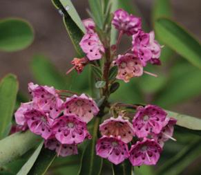
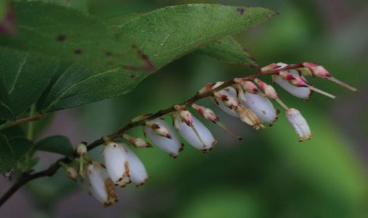
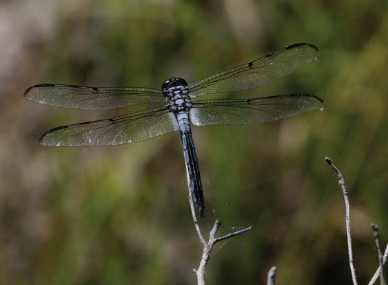
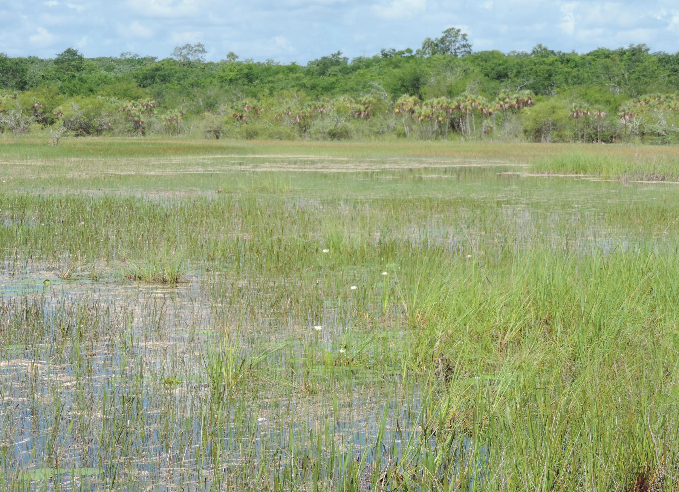
Summer has arrived in New England. The other evening, I saw the flickering of lightning bugs or fireflies which is one sign of summer that I’ve looked forward to since my childhood. As a kid and still as an adult I’m bedazzled by their blinking lights in the dark of night...a land-based example of bioluminescence. Males probably do most of the flashing while in flight in hopes of attracting a female who will flash back if interested. In North America, there are over 150 species representing 16 genera and over 2,000 species of lightning bugs worldwide. Perhaps the most famous are the synchronous fireflies of the Congaree Swamp (South Carolina) – one of three synchronous species whose displays are virtually unrivaled. From mid-May to mid-June these fireflies put on their show in the Swamp. The event is in such demand that the National Park Service now maintains a lottery system for attendance. Another local sign of summer is the blooming of Mountain Laurel (Kalmia latifolia) and I’ve got a huge one about 12 ft tall that resembles a tree in the Serengeti as it stands alone in an open field of ferns.
With this issue, we welcome incoming SWS President Eric Stein and thank outgoing President Susan Galatowitsch for her leadership during the past year (see their
messages). The July issue of WSP is normally devoted to presenting abstracts from our annual conference. However, this year, the conference is being held in Taiwan from November 11–16, so its proceedings will be in the January 2025 issue. So, in the current issue, we have a number of articles along with SWS News and other information (still looking for an Assistant Editor for WSP). The first article is about scientists who pioneered work in monsoonal wetlands in India written by Arnold van der Valk; another contribution to his series of early wetland scientists. The other articles deal with topics such as the Corps of Engineers’ management of Lake Red Rock (Des Moines River, Iowa), the potential of artificial floating wetlands for stormwater treatment in the Pacific Northwest, and the challenges faced by local fishermen in protecting wetlands from degradation from agriculture in Veracruz, Mexico. In addition, we also have two submissions for Notes from the Field – one from two wetland scientists from Mexico on their observations in Quintana Roo and the other from my recent observations from the New Jersey Pine Barrens – two very different ecosystems (temperate vs tropical wetlands).
As usual, we appreciate the contributions and thank the authors for their submissions. We’re looking for articles for the October issue - if interested in writing an article, feel free to contact me at ralphtiner83@gmail.com. SWS members and other readers are interested in hearing about wetland projects and experiences you have. Meanwhile, hope you enjoy this issue.
Happy Swamping!
Ralph Tiner WSP Editor
CONTENTS
Vol. 42, No. 3 July 2024
ISSN: 1943-6254
210 / From the Editor’s Desk
212 / President’s Address
213 / Outgoing President’s Message
214 / SWS Webinars
215 / SWS News
254 / Notes From the Field
261 / Wetlands in the News
262 / Wetland Bookshelf
263 / SWS Submission Guidelines
264 / 2023 Advertising Prospectus
ARTICLES:
217 / Western Science Discovers Indian Monsoonal Wetlands: Winfield S. Dudgeon and Walter T. Saxton Arnold van der Valk
224 / Advancing Lake Red Rock Reservoir Management Practices to Maximize Ecological Benefits: From Planning to Monitoring Chuck Theiling, Alyssa Calomeni, Nicole Bosco, Steve Dinsmore, Hugh Howe, Todd Gosselink, Keith Schilling, Matthew Streeter, and Perry Thostenson
231 / Floating Treatment Wetland and Biomedia Module for Stormwater Treatment and 6PPD Quinone Removal
Lizbeth Seebacher, Brianna Pierce, and Robert Turner
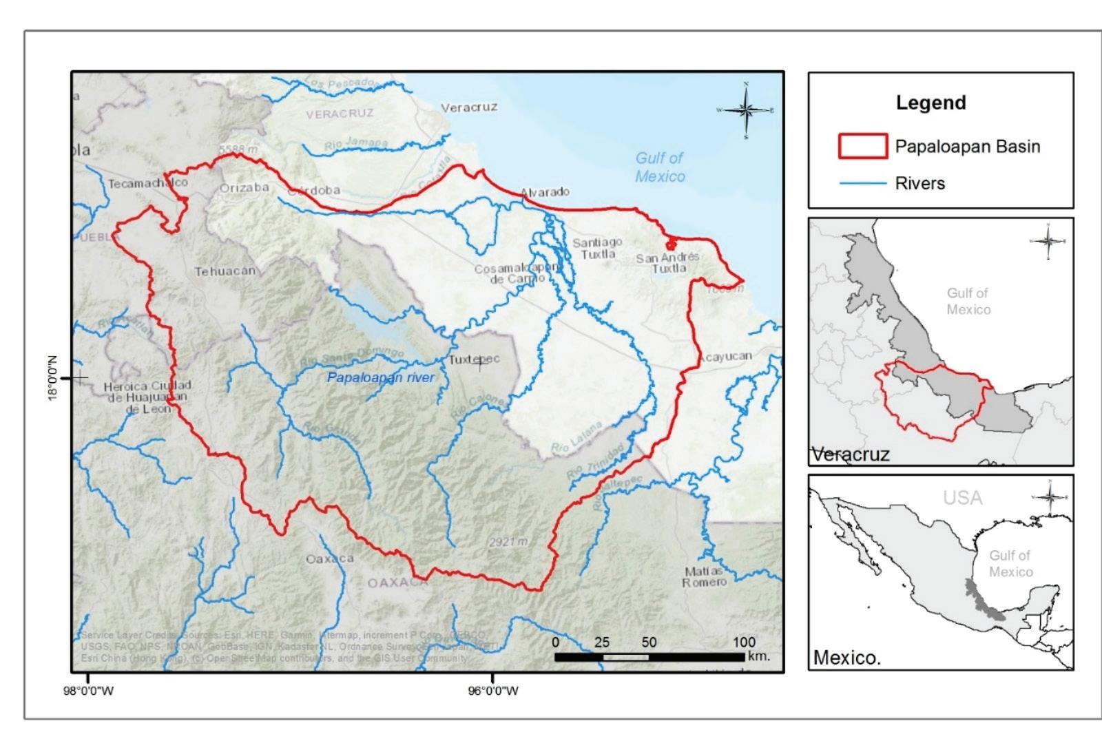
242 / The Use of Wetlands by Fishermen in the Region of the Lower Papaloapan River Basin (Veracruz, Mexico)
Blanca Edith Escamilla Pérez, Martha Judith Hernández Velasco, Xochitl del A. León Estrada, and Hugo López Rosas
&Wetland Science Practice
PRESIDENT / Eric Stein, Ph.D.
PRESIDENT-ELECT / Rebecca Pierce
IMMEDIATE PAST PRESIDENT / Susan Galatowitsch, Ph.D.
SECRETARY GENERAL / Kai Rains, Ph.D.
TREASURER / Yvonne Vallette, SPWS, SWSPCP
EXECUTIVE DIRECTOR / Erin Berggren, CAE
MARKETING MANAGER / Moriah Meeks
WETLAND SCIENCE & PRACTICE EDITOR / Ralph Tiner, PWS Emeritus
CHAPTERS
ASIA / Wei-Ta Fang, Ph.D.
CANADA / Susan Glasauer, Ph.D.
CENTRAL / Lindsey Postaski
CHINA / Ming Jiang
EUROPE / Matthew Simpson, PWS
INTERNATIONAL / Alanna Rebelo, Ph.D. and Tatiana Lobato de Magalhães, Ph.D., PWS
MID-ATLANTIC / Bill Morgante
NEW ENGLAND / April Doroski
NORTH CENTRAL / Casey Judge, WPIT
OCEANIA / Maria Vandergragt
PACIFIC NORTHWEST / Shelby Petro
ROCKY MOUNTAIN / Rebecca Pierce
SOUTH ATLANTIC / Richard Chinn
SOUTH CENTRAL / Jessica Brumley
WESTERN / Richard Beck, PWS, CPESC, CEP
SECTIONS
BIOGEOCHEMISTRY / Katie Bowes
EDUCATION / Darold Batzer, Ph.D. and Derek Faust
GLOBAL CHANGE ECOLOGY / Melinda Martinez, Ph.D.
PEATLANDS / Bin Xu, Ph.D.
PUBLIC POLICY AND REGULATION / John Lowenthal, PWS
RAMSAR / Nicholas Davidson, Ph.D.
RIGHTS OF WETLANDS / Gillian Davies
STUDENT / Deja Newton
WETLAND RESTORATION / Luke Eggering
WILDLIFE / Rachel Fern
COVER PHOTO:
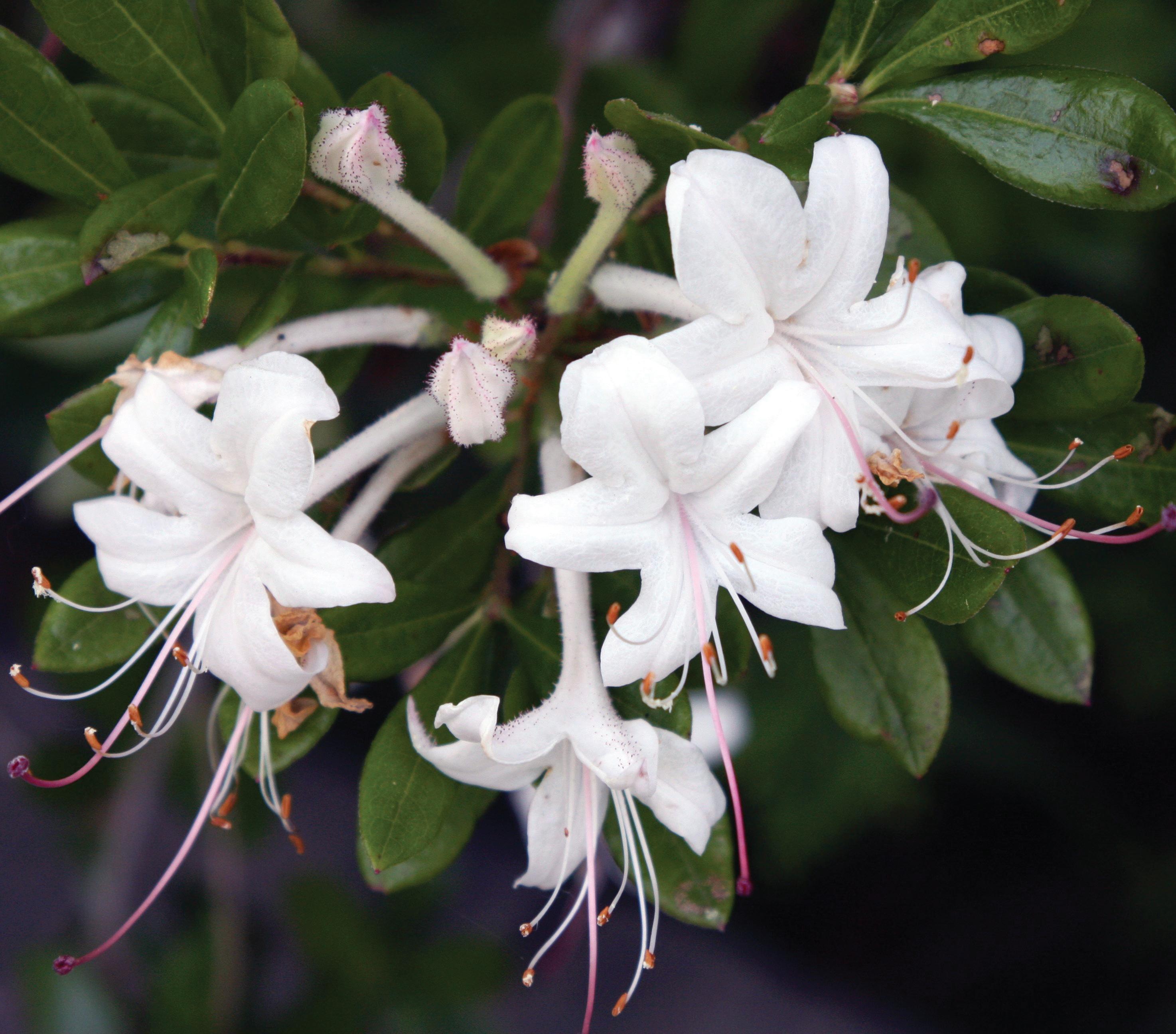
Swamp Azalea (Rhododendron viscosum) blooming in the New Jersey Pine Barrens in June. (Photo by Ralph Tiner)
WOMEN IN WETLANDS / Mo Wise
COMMITTEES
AWARDS / Amanda Nahlik, Ph.D.
EDUCATION AND OUTREACH / Jeffrey Matthews, Ph.D.
GLOBAL REACH / Rebecca Woodward
HUMAN DIVERSITY / Christina Omran
MEETINGS / Yvonne Vallette, PWS
MEMBERSHIP / Kai Rains, Ph.D.
PUBLICATIONS / Keith Edwards
WAYS & MEANS / Yvonne Vallette, SPWS, SWSPCP
WETLAND CONCERNS / Max Finlayson
WETLANDS OF DISTINCTION / Roy Messaros, Ph.D., Steffanie Munguia and Jason Smith, PWS
REPRESENTATIVES
PCP / Christine VanZomeren
WETLANDS / Marinus Otte, Ph.D.
WETLAND SCIENCE & PRACTICE / Ralph Tiner, PWS Emeritus
NAWM / Samantha Vogeler
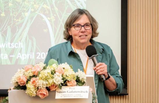
Eric Stein, Ph.D. SWS President
Dear SWS Colleagues, It is an honor to be serving as your President for the coming year. I would like thank Sue Galatowitsch for her leadership over the past year, and I look forward to working with her, the rest of the Executive Board and all the amazing volunteer leaders in SWS over the coming year. As Sue mentioned in her message, this will be an exciting year for the Society and there are many opportunities to get involved. This coming year, we are excited to be partnering with the Taiwan Wetland Society to host our annual meeting in Tiawan – I hope to see many of you there. We will also be continuing our work toward recruiting the first Executive Director in the history of the Society, which will position us to enhance our strategic actions, our partnership with other scientific societies, and service to our membership. Our five-year strategic plan will be updated beginning this year and we will continue to grow our membership particularly with students, early career professionals and wetland scientists and practitioners from outside of North America.
The strength of SWS is the grass-roots participation and commitment across the academic, government, NGO, and private-practitioner communities. I encourage every SWS member to find the way that works best for them to get involved, whether that be on Committees, in local Chapters, in Sections, or by participating in events such as webinars, mentoring groups and local meetings. These interactions are a great way to connect with your colleagues, form partnerships and friendships, and stimulate new opportunities. Collectively, these engagements are what makes SWS function and what allows it to provide its service to our members and the larger wetland community.
I recently had the chance to visit some of the remnant blanket bogs of Ireland, 75% of which have been lost. Experiencing these amazing wetlands reinforced the importance of the work we all do every day to protect, restore, manage and increase understanding and awareness of the function and importance of the world’s Wetlands. I look forward to working with all of you to enhance the role of SWS in supporting these efforts through service to our membership.
I hope to see you in Tiawan and in workgroups over the course of the year.
Warmly,
Eric Stein President,
SWS
Ph.D.
University of Minnesota
Immediate Past President
Dear Colleagues, I’ve enjoyed serving as SWS President this past year and working with many of you to advance our work as wetland scientists. SWS is truly a “bottom up” organization that functions as well as it does because most of our activities to promote wetlands are regionally focused through chapters or topically oriented through sections. SWS sustains its momentum because of our incredible network of volunteer leaders. It takes approximately 185 people serving in leadership roles (i.e., as officers or committee members) to keep the 37 groups that make up SWS moving forward. That’s about 7% of SWS members! Most of us (including me) spend most of our years as SWS members not in leadership positions, but benefiting greatly from our collective corps of volunteer leaders. What’s great about stepping up to take your turn as a SWS leader is that the benefits to you are even greater. It’s hard to overstate how enriching my
year as SWS President has been to me – getting to know so many of you and to be inspired by your efforts.
Throughout the year, I’ve occasionally reflected on how much of a difference individuals can make in organizations like SWS. Whether it’s revitalizing a committee, starting a new section, hosting a meeting, launching a new initiative, mentoring a new wetland professional, or reliably producing a publication – we are fortunate to have dedicated members committed to SWS. Thank you!
I look forward to working with you in the coming year as I continue on the Executive Board as Immediate Past President. The year ahead is a crucial one for moving forward on building our capacity as an organization with an executive director, for supporting emerging chapters around the world, for strategic planning, and to ensure we efficiently and effectively facilitate the work of all chapters, sections and committees.
Thanks again for your contributions to SWS and, as importantly, to your collegiality! Hope to see you at the 2024 Annual Meeting in Taiwan!
Sue Galatowitsch Immediate Past President, SWS
Susan Galatowitsch,
English:
July 18 | 1:00 PM ET
Topic: Prioritizing Floodplain Reconnection to Improve Ecohydrological River Corridor Function
Speaker: Liz Doran
August 15 | 1:00 PM ET
Topic: TBD
Speaker: TBD
September 19 | 1:00 PM ET
Topic: TBD
Speakers: Royal Gardner, Bob Kerr, James Thomas
Spanish:
September 25 | 1:00 PM ET
Topic: TBD
Speakers: Sergio Alejandro Guarín Torres and Jenny Patricia Veloza Torres
NOTE: Webinar Topics and Speakers are subject to change. Visit the SWS Event Calendar for the most recent details and for future webinar dates.
THANK YOU TO OUR 2024 WEBINAR SERIES SPONSORS
EARLY BIRD REGISTRATION ENDS JULY 15TH!
The SWS 2024 Annual Meeting will be here before you know it, and the meeting planners are working hard to deliver an unforgettable inaugural SWS meeting in Asia! The theme of the 2024 SWS Annual Meeting is “Wetlands and Global Change: Mitigation and Adaptation.” Wetland contributions to biodiversity, carbon storage, climate change, and public safety will be highlighted as the world actively responds to global change challenges. This conference is being hosted with National Park Service, Ministry of the Interior, Taiwan, Republic of China (ROC) and co-hosted with the Asia Chapter of the Society of Wetland Scientists and will be the first SWS Annual Meeting held in Asia, marking a new era for the growing importance of Asian wetlands and contributions being made by Asian wetland scientists.Visit the SWS 2024 Annual Meeting website to check out information available now like:
• a list of plenary speakers
• descriptions of field trip offerings
• information on visiting Taiwan
Don’t wait to register! Secure your spot before early bird pricing ends. Get excited to explore the Taiwanese wetlands with SWS.
Register Now
Opportunity for Career Development — Assistant
Editor of Wetland Science & Practice
Having been the editor of Wetland Science & Practice for a decade or so, it is time to get someone ready to move the journal forward after mid-2025. During my tenure, we’ve been able to take the journal into the digital realm as a fullcolor e-publication and have re-established the process of assigning doi codes to articles to make them more readily available online. To make the transition seamless in anticipation of my retirement by 2026, we’d like to have someone come onboard as an Assistant Editor (AE) for the next year or so with the expectation that the AE would assume the Editor’s position by the end of 2025. The duties would be to help the Editor contact local chapters for possible contributions, review contributions for their suitability for publication and suggest edits, coordinate any additional peer review as necessary, and learn the process of working with our support staff in getting the issue posted online. In terms of a time commitment, most issues require about 3-4 days of work from the Editor so the AE would spend a day or so four times a year. As far as qualifications are concerned, the best candidates would have some experience in writing scientific papers/publications and articles for the general public on the ecology or natural history of wetlands. FYI, the Society’s budget includes a travel stipend for the Editor to attend the Society’s annual meeting. If interested, please send a note to me...Ralph Tiner, Editor WSP at: ralphtiner83@gmail.com. Thanks for your consideration.
SWS-Africa Wetlands Training Course:
First Announcement
We are very excited to announce our 2024 wetlands training course from 7 to 9 October 2024 in Lagos, Nigeria
This 3-day wetlands training course is titled: “Introduction to Wetlands and the Assessment of their Ecological Condition and Ecosystem Services” and aims to equip practitioners, managers, decision-makers, researchers, and students with fundamental wetland skills and knowledge. Please visit our website to learn more!
WHAT IS THE COURSE ABOUT?
• The drivers of wetland ecological condition (hydrology, geomorphology, water quality and vegetation);
• Wetland identification and classification;
• Wetland ecosystem services;
• Available wetland ecological condition assessment tools (the WET-Health and miniWET-Health citizen science tool);
• A brief introduction to wetland rehabilitation concepts; and
• GIS skills for wetland assessments
WHAT DOES IT COST?
Registration Deadline Price (USD) Price (Naira)
Early bird; 31 Aug 2024; $180; ₦270,000
Late registration; 30 Sep 2024; $220; ₦330,000
This covers the following:
• Digital course notes
• Supporting documents and materials for practical assignments
• Digital copies of selected guidelines and tools and other material
• Lunches and teas for three days
• The fieldtrip
• Assessment and certificate
WHO SHOULD ATTEND?
Practitioners, managers, decision-makers, researchers and students whose work currently involves wetlands, or who wish to move into the wetland field of practice. The course is designed at a professional level; thus participants are expected to have a basic degree in natural sciences or equivalent qualification; and will benefit from some knowledge of geography, Geographic Information Systems, soil science, and ecology. This course is suitable both for beginners and those who already have some wetland knowledge.
All are welcome! We hope to meet you there :)
Register Now
Western Science Discovers Indian Monsoonal Wetlands: Winfield S. Dudgeon and Walter T. Saxton
Arnold van der Valk1
ABSTRACT
The first ecological studies of Indian monsoonal wetlands were conducted by an American missionary and botanist, Winfield Dudgeon, and a British botanist, Walter Saxton. During the 1920s, both studied seasonal changes in the vegetation of depressions on the Gangetic Plain in northern India. Up to 95% of the annual precipitation in this area falls during the summer monsoon (June to September). Consequently, these depressions are flooded during and after the monsoon, and wetland vegetation is found in them. After these depressions go dry, one or more dry land vegetation types, often grassland, are found in them that persist until the next monsoon. Ecologists had not previously described such extreme intra-annual changes in vegetation. Dudgeon and Saxton developed new theoretical frameworks to describe and classify this novel kind of vegetation change. Dudgeon proposed the concept of “seasonal succession.” Saxton rejected Dudgeon’s idea that seasonal vegetation changes were a form of succession. As an alternative, Saxton proposed the concept of “mixed formations in time.” In other words, different vegetation types or phases (wetland or dry land) were found during wet and dry periods each year. Dudgeon and Saxton pioneered the study of the impacts of large water-level changes on wetlands. They demonstrated it was propagules of wetland and upland plant species in the soil that enabled them to survive seasonally adverse environmental conditions, allowing them to persist in depressions from year to year.
INTRODUCTION
“A given area [in northern India] is subject to far greater extremes of humidity than is often experienced in temperate zone habitats. 90 per cent of the rain falls in three months, from the middle of June to the middle of Septem-
ber. During the rainy period, a given area may be a wet meadow, or, if the soil becomes waterlogged and drainage is inadequate, it may, towards the close of the period, become a swamp or a lake. After the rains cease, it gradually dries, and for six months or more is capable of supporting only a xerophytic flora” (Kenoyer 1924).
Although botanists had done significant work on the taxonomy of Indian plants in the 19th Century and early 20th Century, ecological research began only in the 1920s (Barucha 1975; Singh 2011). India’s first ecologists were American missionaries trained as botanists (Winfield Dudgeon and Leslie Kenoyer) who took positions at a Christian college in Allahabad and a British botanist (Walter Saxton) who came to Ahmedabad via South Africa. Although they were familiar with various types of vegetation change, as described by Cowles (1911) and Clements (1916), these pioneering ecologists who grew up and were educated in the temperate zone were ill-prepared to make sense of the dramatic seasonal changes in vegetation found in subtropical Indian wetlands. As noted by Kenoyer (1924), there was no known temperate zone equivalent to the intra-annual changes in vegetation that occurred in the monsoonal wetlands of the Upper Gangetic Plain. Winfield Dudgeon (1920) and Walter Saxton (1922, 1924) believed that the intra-annual vegetation dynamics of monsoonal wetlands could not be accommodated in contemporary theories of vegetation change. Consequently, they had to propose new ones. Dudgeon (1920) proposed the concept of seasonal succession, while Saxton (1922, 1924) proposed mixed formations in time.
1
MONSOONS AND MONSOONAL
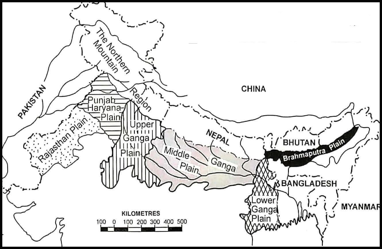
The Indo-Gangetic Plain covers northern and northeastern India and parts of Pakistan and Bangladesh (Figure 1). The plain is bounded on the north by the Himalayas, the source of its rivers, on the south by the Peninsular Plateau, and on the east by the Bay of Bengal. This region is covered by alluvial soils deposited by its major rivers and their tributaries. The Upper Gangetic Plain, which the Ganges River and its tributaries drain, runs about 550 km east-west and 380 km north-south with an elevation between 100 to 300 m. The climate of the Gangetic Plain is subtropical, with three distinct seasons: cool (winter), hot, and rainy (monsoon) (Figure 2). Winters are cool, with average temperatures in January between 11 °C (52 °F) in the north and 15 °C (59 °F) in the southeast. It is hot and dry from mid-March to June before the monsoon’s onset, and temperatures can reach 45 °C (113 °F). During the summer monsoon, which starts in June, temperatures decrease and humidity increases. Annual rainfall ranges from approximately 600 millimeters (23 inches) in the northwest to 1,300 mm (51 in.) in the southeast. The monsoon ends in mid to late September or early October. Nearly all of the region’s annual precipitation (up to 95%) occurs during the summer monsoon. For more information about India’s summer monsoon, see Yadav (2008).
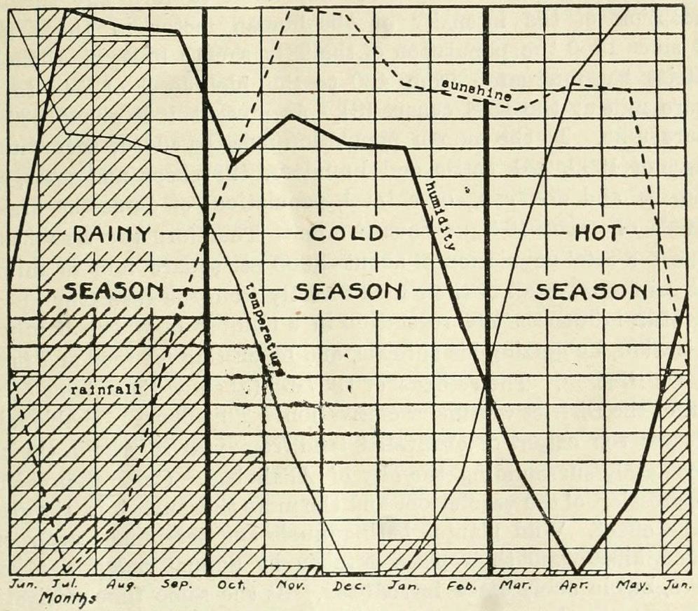
Figure 2. “Mean temperature [thin solid line], mean sunshine (mean cloudiness curve inverted] [dashed line], mean rainfall [hatched areas], and mean relative humidity [thick solid line] for the year at Allahabad, so calculated that all the maxima touch the top of the graph and the minima touch the bottom. This emphasizes the three climatic seasons [rainy, cold, and hot], which determine three corresponding vegetational seasons.” (Dudgeon 1920).
Figure 1. The Indo-Gangetic Plain and its subdivisions. Courtesy of the Union Public Service Commission of India.
The Upper Gangetic Plain has numerous shallow depressions, both natural and man-made. Because of its monsoonal climate, shallow depressions fill with water (up to 3 m deep) during the rainy season, and wetland vegetation develops. These flooded depressions gradually dry out in the following winter and spring months, and their wetland vegetation dies and decomposes, leaving only seeds and perennating organs behind. When they dry out, upland plant communities develop in these depressions. The reflooding of the depressions eliminates this upland vegetation during the next monsoon (Misra 1946; Gopal 1986). Depending on the depth of the depression, the amount of rainfall during the monsoon, grazing, and irrigation withdrawals, the length of time the depressions are dominated by wetland and upland vegetation varies from year to year, as does, to some extent, the composition of the wetland and upland vegetation (Misra 1946).
WINFIELD SCOTT DUDGEON (1886–1932)
Winfield Dudgeon (Figure 3) was born in Hedrick, IA, and died in 1932 in Ames, IA, while on leave from Ewing Christian College. He graduated from Iowa State College (now University) in 1907 and took a teaching position at Central College, Pella, IA. He did his postgraduate studies at the University of Chicago. In 1912, Dudgeon, as a missionary, went to teach at Ewing Christian College in Allahabad (Stewart 1982) and was associated with the College until his untimely death. Allahabad is in the northcentral Indian state of Uttar Pradesh at the confluence of the Ganges and Yamuna Rivers. Dudgeon founded Ewing’s Department of Botany and, in 1920, was involved in the organization of the Indian Botanical Society, serving as its first president.
In 1920, Dudgeon published a paper with the uninformative title, “A contribution to the ecology of the Upper Gangetic Plain,” in the Journal of Indian Botany. It describes the climate, geology, and vegetation within a ten-mile radius of Allahabad. He emphasized the importance and novelty of his study by noting that “For the most part, studies in plant succession have been made in temperate regions, where there is but one vegetational season, the summer or growing season. This is followed by a winter season during which the vegetation is at more or less of a standstill. In the Upper Gangetic Plain, there is no season in which growth is impossible. Growth is checked and the vegetation modified by the aridity of the hot season, and at all seasons and every stage it is interfered with even to the extinction point by the human factors.” For the first time, Dudgeon documented the dramatic seasonal changes in the structure and composition of the vegetation in low-lying areas on the Gangetic Plain.
Dudgeon (1920) described his study area as “… monotonously level. Here and there are slight natural depressions that become shallow lakes during the rainy season, but which are dried up later by evaporation and by use of
the water for irrigation purposes.” He noted the importance of three factors controlling the distribution and composition of the vegetation in monsoonal wetlands: topography (depth of depressions), seasonal climatic changes, and human disturbances, especially grazing by domestic animals. “The climatic factors, rainfall, insolation, temperature, humidity, and air movements, are periodic in distribution, and produce three distinct seasons (Figure 2). (a) Rainy season, from the middle of June to the end of September, with high rainfall, low insolation, high temperature, and high humidity. (b) Cold season, from the first of October to the end of February, with low rainfall, high insolation, low temperature, and high humidity. (c) Hot season, from the first of March to the middle of June, with low rainfall, high insolation, high temperature, low humidity, and large air movement” (Dudgeon 1920). At Allahabad, about 94% of the annual rainfall occurs during the monsoon (rainy season).
In a depression over a year, the vegetation changes from aquatic vegetation to wet meadow to dry meadow. Dudgeon describes this as “seasonal succession.” “A third type of succession is a prominent feature in a strongly periodic climate. It is illustrated by the striking changes in the
Figure 3. Winfield S. Dudgeon around the time of his graduation from Iowa State College. (The Bomb, 1907, ISC Yearbook. Courtesy of the Iowa State University Digital Archives).
aspect and content of the vegetation from season to season and may be called seasonal succession. As a result of the three well defined climatic seasons, rainy, cold, and hot, there are three equally well marked vegetational seasons.”
Dudgeon did his postgraduate work at the University of Chicago, the home of Henry Cowles, one of the most influential early American researchers of vegetation change. To try to make sense of the intra-annual changes in monsoonal wetlands, Dudgeon turned to Cowles’ 1911 paper on vegetation cycles. Cowles (1911) is the only paper on vegetation dynamics cited by Dudgeon (1920).
There had been various models of vegetation change or succession proposed by 1920. Still, all of them had one thing in common, succession was considered an interannual, not an intra-annual, phenomenon. Clements (1916) proposed that succession is a directional and deterministic phenomenon that results in a final stage, the climax, in equilibrium with the regional climate. For Clements, succession typically took hundreds or thousands of years. Cowles (1911) described vegetation changes as nested temporal cycles (climatic, topographic, and biotic) at three different time scales: “Each climatic cycle has its vegetative cycle; each erosive [topographic] cycle within the climatic cycle, in turn, has its vegetative cycle; and biotic factors institute other cycles, quite independently of climatic or topographic change.” For Cowles, vegetation change can occur over thousands or tens of thousands of years (climatic cycles), hundreds or thousands of years (topographic/erosional cycles), and decades or centuries (biotic cycles). To Cowles’ three vegetation cycles, Dudgeon added a fourth, much shorter cycle, seasonal succession, driven by intraannual changes in water levels.
By considering intra-annual changes in vegetation in monsoonal wetlands to be a type of succession, Dudgeon made two missteps. A successional sequence implies that every vegetation stage somehow prepared the way for the next stage. This was widely assumed to be the case in the early 20th Century (Clements 1916). However, this is not the case in monsoonal wetlands. Dudgeon also failed to differentiate his seasonal succession cycle from less extreme seasonal changes in vegetation, a feature of all kinds of vegetation. Although seasonal succession could be a logical extension of Cowles’s cyclical conception of vegetation change, Indian and other ecologists have never embraced Dudgeon’s seasonal succession (Misra 1946, see below). Nevertheless, Dudgeon described a wetland type previously unknown to European and American ecologists. He also documented the importance of water-level fluctuations for understanding wetland vegetation dynamics in India.
WALTER THEODORE SAXTON (1882–1973)
Walter Saxton was born in Great Britain and studied botany at the University of Cambridge, from which he received a Bachelor of Arts. In 1906, he became an assistant to Profes-
sor H.H.W. Pearson in the Department of Botany at South African College, Cape Town. During his seven years at South African College, Saxton published 14 papers, primarily in plant embryology and conifer taxonomy. However, during the summer of 1911–1912, he was involved in a descriptive study of the vegetation of the Manubie District, Cape Province (Saxton and Péringuey 1917). In 1913, Saxton left South Africa to accept an appointment as the professor of botany at Gujarat College in Ahmadabad, Gujarat, India. Later he held positions at Reading University and the University of Cape Town, the successor of South African College.
In 1922, Saxton published two papers on the vegetation of the Gangetic Plain. Dastur and Saxton (1922) is an unremarkable study of factors controlling the distribution of savanna species in an area near Ahmadabad. However, Saxton (1922) is a remarkable paper on seasonal vegetation changes due to north India’s monsoonal climate. Saxton’s 1922 paper was published in the Journal of Indian Botany, the same journal in which Dudgeon had published his 1920 paper.
Saxton (1922), in his Introduction, makes clear why he is publishing this paper: “The writer has always deprecated the action of those persons who evolve new theories, from a priori considerations, out of their own inner consciousness, without any material evidence to support them, as well as of those who glean some facts from half a dozen published sources, diligently select those favourable to a particular pet theory, ignore all the other facts which do not fit it and rush into print. It seems, therefore, advisable to state that the theory to be developed here has not arisen in either of these two ways. It is based mainly on some ecological work which is being carried on at the present time by the writer and some of his students. This work is likely to be continued for some months at least and meanwhile, the idea gradually crystallizing from it seemed sufficiently important, in its relation to Indian ecological problems, to justify this attempt to complete the crystallizing process. It is proposed rather to explain the idea than to give details of the facts which first led to its adoption.” Saxton’s 1924 paper “Phases of vegetation under monsoon conditions” would contain the promised data.
Saxton had an ax to grind but named no names, and his paper contains no references. He takes to task his unnamed adversary because of a failure to recognize that India’s vegetation can never be adequately described or classified using existing Western models of vegetation change. “I know of no work in recent years which has suggested any broad basis upon which detailed ecological studies in India may rest. … The result has been that those who have tried to define Indian plant communities have quite definitely made an attempt to fit them into the systems which have evolved in the last twenty years from the ecological work done in Western countries. Those systems are already comparative-
4. Annual vegetation phases (mixed formations in time) in a low-lying area on the Gangetic Plain, India. (Adapted from
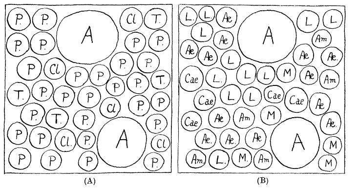
Figure 5. Idealized maps of each plant species in a small plot: (A) during the grassland phase and (B) during the marsh phase. The only species found in both vegetation phases was A — Andropogon annulatus. A = Andropogon annulatus [perennial]; Æ = Æchynomene indica [annual or perennial]; Am = Ammania auriculata [annual]. Cae = Caesulia axillaris [annua]; Cl = Cleome viscosa [annual]; L = Ludwigia parviflora [annual]; M = Melochia corchorifolia [herbaceous perennial]; P = Panicum prostratum [annual]; T = Trianthema monogyna [annual] (Saxton 1924).
ly rigid and the task of fitting our plant communities into them is not an easy one. Indeed I have come to the conclusion that it cannot be done, at least not on the lines which have been hitherto attempted” (Saxton 1922). Although not named, Winfield Dudgeon’s “seasonal succession” obviously is Saxton’s target.
Saxton (1922) goes on to make it clear why Western vegetation models are not suitable for India: “… the great difference between Europe and America on the one hand and India on the other is that the former really have no habitat which even approximately corresponds to the Indian monsoon habitat …. Seasonal differences are found in other habitats, but I believe it must be admitted that they are much less profound and far-reaching than those in the monsoon habitat as we see it in its typical development.” Saxton (Figure 4), like Dudgeon, recognizes significant seasonal changes in environmental conditions over a year: “… we often find that during the year two (or it may be three)
profoundly different sorts of conditions are met within the same spot. Practically, these constitute two (or three) entirely different habitats. First, a condition when both soil and air may be almost continuously water-saturated for about three months … [Second] at the close of the monsoon, the soil and air both gradually dry, and after about a month, a period of seven months of intense and absolute drought sets in.” The vegetation found during the rainy season (some kind of wetland) has nothing in common with that of the dry season (called xerophytic by Saxton) (Figures 4 and 5).
Out of hand, Saxton dismisses the idea that monsoonal habitats undergo some form of succession: “… this is not succession as understood in Oecology. Probably this will be universally admitted and it will not be necessary to discuss the point further.” After dismissing Dudgeon’s seasonal succession without referencing it, Saxton presents his new concept: mixed formations in time. “The theory is advanced that in such an area it often happens that we cannot regard
Figure
Saxton 1922).
a small and reasonably homogeneous part of it as occupied by a single unit (“formation”) of vegetation, but rather that two (or even three) entirely different plant communities regularly alternate with one another, though each persists to some extent through the dominant phases of the other, thus giving rise to the idea of “Mixed formations in time”.” In other words, Saxton proposes that monsoonal depressions have two or more phases (Figures 4 and 5). However, these seasonal phase shifts are not a form of succession because one phase does not give rise to or permanently replace another. For Saxton, the various phases are independent entities that exist simultaneously. While one phase is extant, the other(s) is(are) latent. The latter exist mainly as dormant seeds and vegetative propagules until environmental conditions change sufficiently. “Mixed formation in time” was not the aptest name for Saxton’s new concept, and his 1924 paper uses the more descriptive and intuitive “vegetation phases” in its title.
The seasonal shifts in vegetation in monsoonal depressions on the Gangetic Plain described by Dudgeon (1920) and Saxton (1924) are very similar. Dudgeon (1920) better describes the region’s monsoonal climate (Figure 2), whereas Saxton (1924) better describes and illustrates the vegetation phases (Figures 4 and 5). He also notes the importance of the seed bank and vegetative propagules for enabling species to persist from year to year in a wetland. The seed banks of monsoonal wetlands would not be studied for another 60 years (Middleton et al. 1991). In an attempt to determine what anatomical and morphological adaptations allow plant species to grow in a monsoonal area, a large part of Saxton (1924) is devoted to anatomical studies of selected plant species, a common type of ecological study that started in 19th Century Germany and persisted into the early 20th Century (van der Valk 2011, 2014).
DISCUSSION
The intra-annual vegetation phases of northern Indian monsoonal wetlands are an extreme example of comparable intra-annual cycles in wetlands in other parts of the world. Others include those found in seasonal prairie wetlands in North America (van der Valk and Mushet 2016), playa wetlands in North America (Bolen et al. 1989), and monsoonal wetlands in northern Australia (Finlayson 2005). Dudgeon was born in Mahaska County, Iowa, south of the Prairie Pothole region. Still, he studied botany at Iowa State College (now University) in Ames, Iowa, which is in the Prairie Pothole region. Much of the early work on the vegetation dynamics of prairie potholes was done in Iowa, much of it close to Ames (van der Valk 1981, 2005). Ironically, Dudgeon, while a student in Ames, could have observed similar, but less extreme, seasonal changes in pothole vegetation to those he later studied in north India. Dudgeon (1920) and Saxton (1922, 1924) described what was, for them, a new kind of wetlands that was
unknown to Western ecologists at the time. Although they studied the same wetlands, they differed in how they interpreted their intra-annual vegetation changes. Dudgeon described them as a new type of succession: “seasonal succession.” In contrast, Saxton described them as a new type of vegetation dynamic: “mixed formations in time” or “phases of vegetation.” From my perspective as someone who worked on the vegetation dynamics of monsoonal wetlands in northern India (Middleton et al. 1991, van der Valk and Middleton 2024), Saxton’s conceptualization of their vegetation dynamics as a series of vegetation phases better describes them than Dudgeon’s “seasonal succession.” However, it took 40 years for me to reach this conclusion (van der Valk and Middleton 2024). I made the mistake Saxton (1922) warned about when I began working in India in the 1980s. I interpreted the vegetation dynamics of monsoonal wetlands as a compressed habitat cycle, a type of cyclical succession found in semi-permanent prairie potholes in North America (Middleton 1999, van der Valk 1981, 2005). I studied habitat cycles in Iowa in the late 1970s and early 1980s. Habitat cycles are cyclical changes that occur over one to two decades (van der Valk 1981, 1982, 2005). In other words, I unconsciously adopted Dudgeon’s seasonal successional model in the guise of a compressed habitat cycle completed in only one year.
How much impact did Dudgeon and Saxton’s work have on the development of wetland science in India and elsewhere? Dudgeon (1920), according to Google Scholar, at the time of writing, has only been cited 36 times, mainly since the 1980s. However, Misra (1962), in a review paper on Indian vegetation studies, credits Dudgeon as the first ecologist to apply the concept of succession to Indian vegetation. However, Misra also faults Dudgeon for not taking a multiyear approach to the vegetation dynamics of monsoonal wetlands. Based on Misra’s studies of monsoonal wetlands (Misra 1946), the species composition of the vegetation of each climatically distinct part of a year (rainy, cool, hot) is very similar from year to year, e.g., the meadow vegetation in one year is very similar in composition to that in subsequent years. For Misra, no succession is occurring. Strangely, in his review paper, Misra does not cite Saxton’s papers. According to Google Scholar, Saxton (1922) has been cited only seven times, and Saxton (1924) 27 times. Saxton (1922) deserves to be recognized as a classic paper in wetland science. Its message — don’t let your past experiences close your eyes to a new reality — is as relevant today as it was in the 1920s.
After Dudgeon and Saxton, no scientific studies of monsoonal wetlands were conducted in India until the 1940s, when Ramdeo Misra (1908-1998) returned to India (Gopal 1986) after doing postgraduate research in England (Ph.D., 1937, Leeds) with the renowned t wetland ecologist W. H. Pearsall. On his return to India, Misra conducted ecological studies of northern India’s low-lying lands, ponds,
and herbaceous plant populations from 1937 to 1946 (Singh 2011). These studies (Misra 1946) confirmed much of what Dudgeon and Saxton had previously described but showed that the intra-annual vegetation changes found were more complicated than previously realized. Misra laid the foundations for field and experimental ecological studies at Indian academic and other organizations (Singh 2011). After Misra, no significant new studies of monsoonal wetlands were conducted in India until the 1980s.
Dudgeon and Saxton are important, if sadly littleknown and celebrated, figures in the history of wetland science. They contributed to wetland science in three significant ways. One, they made wetland science a genuinely international discipline by highlighting that there were wetland types not found in the West. Two, they pioneered the study of the impacts of water-level changes on wetlands, an important topic in contemporary wetland ecology. Three, they demonstrated that monsoonal vegetation is well adapted to large changes in water levels because propagule banks allow both wetland and upland plant species to survive either drawdowns or periods of flooding.
REFERENCES
Bharucha, F.R. 1975. Fifty years of ecological and phytosociological research in India. Vegetatio 30: 153-155. .jstor.org/stable/20036864
Bolen E.G., L.M. Smith, and H.L. Schramm. 1989. Playa lakes: prairie wetlands of the southern high plains. Bioscience 39: 615–623. doi. org/10.2307/1311091
Clements, F.E. 1916. Plant Succession: An Analysis of the Development of Vegetation. Carnegie Institution of Washington, Washington, DC. Cowles, H.C. 1911. The cause of vegetation cycles. Botanical Gazette 51: 161-183. doi.org/10.1086/330472
Dastur, R.H. and W.T. Saxton. 1922. The oecology of some plant communities in the savannah formation. Journal of Indian Botany 3: 34-51.
Dudgeon, W. 1920. A contribution to the ecology of the Upper Gangetic Plain. Journal of Indian Botany 1: 296-324.
Finlayson, C.M. 2005. Plant ecology of Australia’s tropical floodplain wetlands: a review. Annals of Botany 96: 541–555. doi.org/10.1093/aob/ mci209
Gopal, B. 1986. Vegetation dynamics in temporary and shallow freshwater habitats.
Kenoyer, L.A. 1924. Plant life of British India. The Scientific Monthly 18: 48-65. jstor.org/stable/7150
Middleton, B.A. 1999. Succession and herbivory in monsoonal wetlands. Wetland Ecology and Management 6: 189–202. doi. org/10.1023/A:1008495121557
Middleton, B.A., A.G. van der Valk, D.H. Mason, R.L. Williams, and C.B. Davis. 1991. Vegetation dynamics and seed banks of a monsoonal wetland overgrown with Paspalum distichum in northern India. Aquatic Botany 40: 239-259.
Misra, R. 1946. A study in the ecology of low-lying lands. Indian Ecologist 1: 1–20.
Misra, R. 1962. The science of vegetation with reference to India. Bulletin of the Botanical Survey of India 4: 113-118.
Saxton, W.T. 1922. Mixed formations in time: a new concept in oecology. Journal of Indian Botany 3: 30-33.
Saxton, W.T. 1924. Phases of vegetation under monsoon conditions. Journal of Ecology 12: 1-38. doi.org/10.2307/2255545
Saxton, W.T. and L. Péringuey. 1917. Oncological notes on the district of Manubie, Transkei. Transactions of the Royal Society of South Africa 6: 37-44. doi.org/10.1080/00359191709520173
Singh, J.S. 2011. Ecology in India: Retrospect and Prospects. Bulletin of the National Institute of Ecology 22: 1-13.
Stewart, R.R. 1982. Missionaries and clergymen as botanists in India and Pakistan. Taxon 31: 57-64. doi.org/10.2307/1220590
van der Valk, A.G. 1981. Succession in wetlands: a Gleasonian approach. Ecology 62: 688–696. doi.org/10.2307/1937737
van der Valk, A.G. 1982. Succession in temperate North American wetlands. In B. Gopal, R.E Turner, R.G. Wetzel, and D.F. Whigham (eds.). Wetlands: Ecology and Management. National Institute of Ecology and International Scientific Publications, Jaipur, Rajasthan, India. pp. 169179.
van der Valk, A.G. 2005. Water-level fluctuations in North American prairie wetlands. Hydrobiologia 539: 171–188. doi.org/10.1007/s10750004-4866-3
van der Valk, A.G. 2011. Origins and development of ecology. In B. Brown, K. de Laplante and K. Peacock (eds.). Philosophy of Ecology Vol. 11 of the Handbook of the Philosophy of Science, Elsevier, The Netherlands. pp. 37-59.
van der Valk, A.G. 2014. From formation to ecosystem: Tansley’s response to Clements’ Climax. Journal of the History of Biology 47: 293-321. jstor.org/stable/43863378
van der Valk, A. G. and B. Middleton. 2024. The vegetation dynamics of the monsoonal wetland of the Keoladeo National Park, India: A reassessment. Hydrobiologia 851: 1625-1636. doi.org/10.1007/s10750-02204962-1
van der Valk, A.G. and D.M. Mushet. 2016. Interannual water-level fluctuations and the vegetation of prairie potholes: potential impacts of climate change. Wetlands 26: 397-406. doi.org/10.1007/s13157-0160850-8
Yadav, R.K., 2008. Changes in the large-scale features associated with the Indian summer monsoon in recent decades. International Journal of Climatology 29: 117-133. doi.org/10.1002/joc.1698
Advancing Lake Red Rock Reservoir Management Practices to Maximize Ecological Benefits: From Planning to Monitoring
Chuck Theiling1, Alyssa Calomeni1, Nicole Bosco2, Steve Dinsmore2, Hugh Howe3, Todd Gosselink4, Keith Schilling5, Matthew Streeter5, and Perry Thostenson3
INTRODUCTION
The Upper Midwest USA has highly developed agricultural landscapes with significant alterations to land cover and hydrology. Landscape conversion eliminated 89 percent of the wetlands and up to 99 percent in the shallow prairie pothole wetlands in Iowa (Bishop et al. 1998). Two flood control dams, Saylorville Lake and Lake Red Rock situated on the Des Moines River above and below Des Moines, Iowa, support extensive wetlands and are managed for multiple uses including flood risk management, low flow augmentation, fish and wildlife management, and recreation, and additionally for hydropower at Lake Red Rock. The Des Moines River reservoir tributary deltas are deemed “Important Bird Areas” by the National Audubon Society that cited its values of rare or unique habitats and significant species concentrations Waterbirds are consistently attracted to these reservoirs during fall migration when declining water levels expose vast mudflats that are colonized by annual plants (Vanausdall and Dinsmore 2021). This heterogeneous habitat is especially attractive to shorebirds (July through September) and waterfowl (August through November). In addition, river nitrate loads were reduced by 4.9 percent, on average, within Saylorville Lake reservoir, with greater nitrate loss occurring in low flow years with greater retention time compared to high flow years with rapid flushing (Stenback et al. 2014). Overall, water quality, wetland, and wildlife benefits occur during the regular, routine management of water levels to maintain the reservoir’s designated uses.
Recognition of the passive environmental benefits achieved in these Iowa reservoirs led US Army Corps of Engineers lake managers and stakeholders to consider actions to increase the ecosystem services derived from Des Moines River flood control dams, including decreasing nitrate concentrations and increasing wetland distribution and waterbird habitat benefits. A Sustainable Rivers Program (SRP) environmental flows workshop (Warner et al. 2014)
was held in 2016 to consider water management measures to increase ecosystem benefits derived from Saylorville Lake and Lake Red Rock. Where the SRP had previously focused primarily on downstream reservoir releases for riverine habitat improvements, the Des Moines River workshop also considered Environmental Pool Management (EPM) which was first implemented on the Mississippi River in 1994. EPM is the modification of reservoir and navigation pool water management to better mimic natural flows while remaining consistent with project authorizations.
The objective of this article is to describe the Des Moines River environmental flows evaluations and recommendations, their codification in new water control regulations, and to introduce the ecological benefits monitoring being conducted at Lake Red Rock.
LAKE RED ROCK
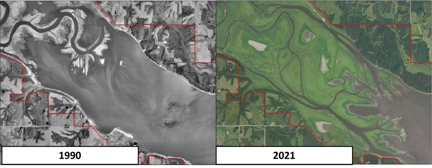
Lake Red Rock is a 6,171 ha (15,507 ac) reservoir formed following the completion of the Red Rock dam on the Des Moines River in 1969; it is the largest lake in Iowa. Flood management activities generally occur only 20 percent of the time during April to May which means water can be managed for environmental purposes the remainder of the year. The Lake Red Rock delta does not replace the dispersed small wetlands of the pre-settlement landscape (now lost), but it does provide approximately 2,800 ha (7,000 ac) of riverine delta habitat with extensive wetlands and mudflats. The “large manmade reservoir” wetland habitat class increased by ~4,000 ha (~10,000 ac) between 1980 to 1997 (Bishop et al. 1998), likely due to delta growth from sedimentation in Saylorville Lake and Lake Red Rock. There has not been any substantial reduction in sedimentation, so delta expansion continues (Figure 1) which is typical of many US reservoirs.
Prior environmental considerations for Lake Red Rock water management were limited to conservation pool maintenance, low flow releases, and a 0.6 m (2 ft) fall reservoir rise to support migratory waterfowl and hunter access to the delta region. In 2018, several environmental and operational needs necessitated a review of the Des Moines River Basin Master Reservoir Regulation Manual (RRM). Key indicators of a need for modifications to the RRM were: 1) significant increases in the magnitude and frequency of flooding events, 2) sedimentation rates within Saylorville Lake, and 3) the need to codify environmental deviations in water-control plans (i.e., EPM) approved from 2016 to 2018 (USACE Rock Island District 2019).
1 US Army Corps of Engineers, Engineer Research and Development Center, Vicksburg, MS, Corresponding author contact: Charles.h.theilng@usace.army.mil
2 Iowa State University, Ames, IA
3 Lake Red Rock, Knoxville, IA
4 Iowa Department of Natural Resources, Knoxville, IA ,
5 University of Iowa, Iowa City, IA
ENVIRONMENTAL FLOWS WORKSHOP
Opportunities to adapt dam operations for increased environmental benefits at Des Moines River flood risk management projects were explored in 2016 using the SRP environmental-flows assessment process developed by USACE and The Nature Conservancy (Warner et al. 2014). This process incorporates collaboration workshops to identify water-management recommendations using stakeholder input from federal (i.e., USACE and U.S. Fish and Wildlife Service), state (e.g., Iowa Department of Natural Resources), and local agencies (e.g., Polk County Conservation), a nongovernmental organization (i.e., TNC), and academic institutions (i.e., University of Iowa and Iowa State University). Environmental flow requirements for specific taxonomic groups (for example, waterbirds, reptiles, fish), wetland habitats, and water quality were key components of reservoir management alterations.
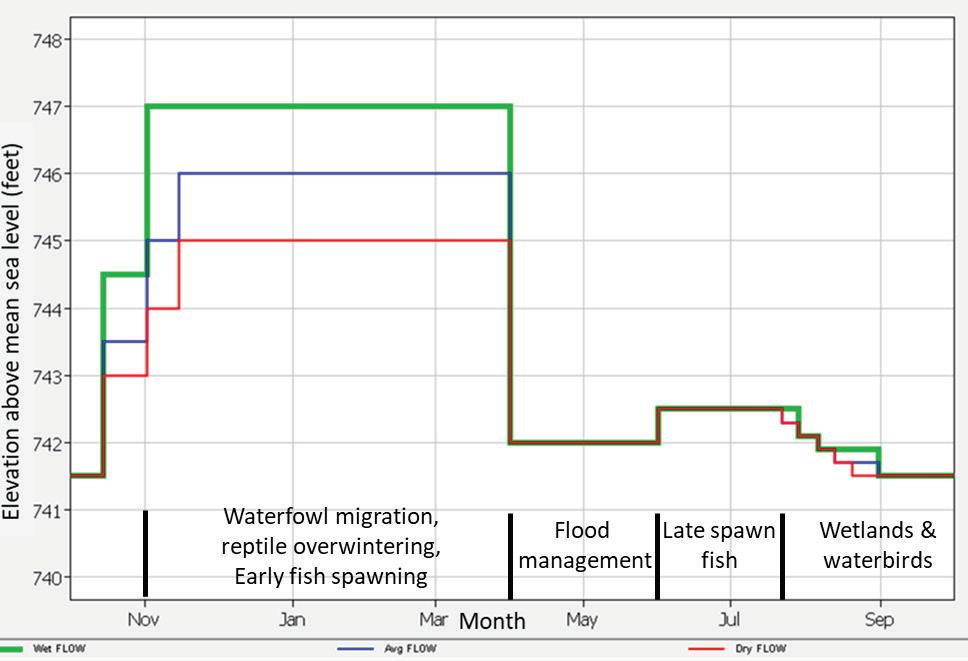
Lake Red Rock environmental flow recommendations (i.e., targeted elevations, durations, and timing) were based on expert hypotheses regarding water level management to positively impact environmental outcomes (Warner et al. 2014). Workshop topics included nitrate concentrations, conditions needed for waterbird migration, and habitat for reptiles. EPM considerations are anticipated to drive the water plan during 80% of a typical operating year. Water levels are held higher in the spring to support fish spawning, they are slowly lowered during summer to promote wetland expansion, they are raised higher during fall waterfowl migration, and held high through winter to support reptile overwintering (Figure 2). The water management plan differs for wet, average, and dry years in anticipation of variable annual hydrology.
Figure 1. Lake Red Rock delta expansion due to sedimentation from 1990–2021 (Source: Todd Gosselink, Iowa Department of Natural Resources)
Figure 2. Lake Red Rock environmental pool management plan for a year.
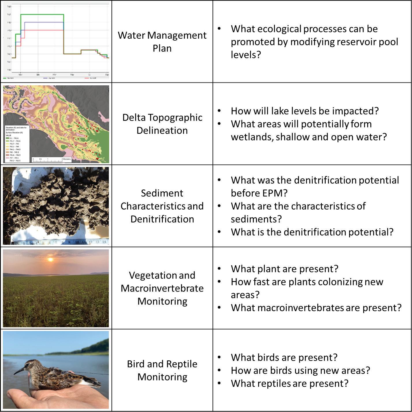
ENVIRONMENTAL BENEFITS MONITORING
Environmental benefits of EPM are being monitored by several researchers. Interdisciplinary research is necessary to consider the full range of environmental effects on water, sediment, plants, and animals for which lake levels can be adaptively managed to optimize outcomes (Figure 3). Ongoing and future monitoring efforts include an assessment of historical reservoir nitrate biogeochemistry data and literature review to document declines in nitrate concentrations prior to implementation of the new EPM plan (Schilling et al. 2023). A delta geomorphic assessment with topographic delineation, sediment mapping, and denitrification analyses to characterize inundation patterns in the delta is underway. Surface water-quality (i.e., temperature, specific conductivity, pH, and dissolved oxygen concentra-
tion) and nitrate concentrations will be evaluated using a boat-mounted spatial analysis system to map water quality conditions throughout the delta (Meulemans et al. 2020). Wetland, waterbird, and macroinvertebrate monitoring are ongoing to quantify these environmental benefits. Reptile overwintering monitoring is using remote radio transmitters deployed at Lake Red Rock.
Geomorphology and Water Quality
The data and literature review included 42 years of longterm upstream and downstream nitrate monitoring records. Lake Red Rock removed approximately 7,000 Mg nitrate per year, representing 12.4% of the nitrate inputs to the reservoir. Estimated annual nitrate removal rates varied considerably based on flow. This study supports that during periods of high nitrate concentrations and loads, reservoir water levels could be manipulated to achieve longer water
Figure 3. Lake Red Rock environmental benefit assessment questions.
retention times achieving greater nitrate removal rates (Schilling et al. 2023).
Lake Red Rock has lost substantial volume over time due to delta progradation which encroached 2.5 miles into the lake between 1994 to 2021 as estimated from National Agricultural Imagery Program imagery (see Figure 2). Sediment physical and chemical characteristics can impact the rate of removal of nitrate within aquatic systems. Field observations identified substantial variation and layering in the delta alluvium related to historical floods that influence surface and hyporheic flow throughout the delta sediment. Altogether, the geomorphic mapping, sedimentology, and nutrient processing rates will be used to further refine models that can predict nitrate removal for water operations within Lake Red Rock. Monthly boat surveys of nitrate concentrations in the reservoir are being conducted to understand how surface water nitrate concentrations are
impacted by seasonal connectivity,
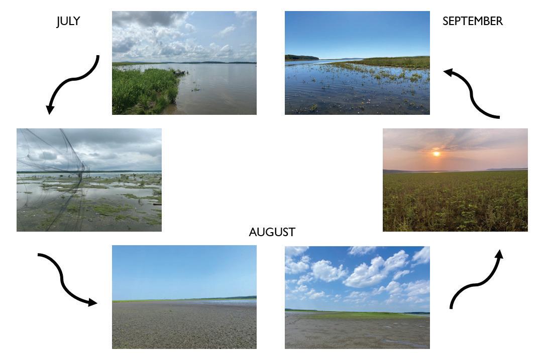
Wetlands
EPM exposes mudflats, promotes vegetation growth, and allows it to seed (Figure 4). These wetland areas serve as an important wildlife food source and provide habitat for migratory waterbirds during fall migration. One objective of wetland vegetation monitoring is to measure vegetation responses (e.g., species diversity and cover) to lower water levels in late summer. Another objective is to link vegetation responses with wildlife benefits.
Vegetation monitoring conducted during summer 2021 and 2022 quantified plant species, diversity, and cover. As water levels dropped and exposed mudflats, approximately two weeks were needed for vegetation to be observed. Within slightly more than a month, 100% vegetation cover
Figure 4. Lake Red Rock delta habitat progression July to September 2021.
was observed. Across both survey years, 19 plant species were identified and included important wildlife foods (Table 1). Thirteen plant species within the mudflat area came to seed and this typically occurred within a month. Vegetation growth slowed in late August indicating that EPM drawdowns should begin in July to ensure a 30-day window for plants to come to seed.
Waterbirds
The Des Moines River corridor, which meanders through the Prairie Pothole Region (PPR) of Iowa, is a major migratory corridor for waterbirds. In particular, the region hosts millions of migratory waterfowl and shorebirds, two groups of birds that are the focus of many management and conservation efforts. Wetlands with diverse habitat conditions (e.g., differing water depths and healthy aquatic plant communities) are critical stopover sites for migratory waterbirds to refuel for the next step in migration. Identifying these stopover sites and understanding how individuals use a site, are critical for future conservation and management efforts (Vanausdall and Dinsmore 2021). Bird use of Lake Red Rock stopover sites is being evaluated by regular visual surveys of the site during fall migration.
A total of 49 waterbird species were documented in 2021 and 44 in 2022 (Table 2). The most prominent subgroups identified included shorebirds (27 spp.) and waterfowl (9 spp.); and all other waterbird groups totaled 14 species (e.g., gulls, terns, and pelicans). On average there were 30 and 26 species recorded per visit in 2021 and 2022, respectively, with species diversity peaking during late August and early September. There were >335,600 individuals counted across all surveys during the fall 2021 and 2022 migration period. American White Pelican (Pelecanus erythrorhynchos) was the most numerous species (approxi-
Scientific name
Common name
Echinochloa crus-galli Barnyardgrass
Xanthium strumarium Rough cocklebur
Phalaris arundinacea Reed canarygrass
Leersia oryzoides Rice cutgrass
Cyperus spp. Flatsedges
Amaranthus palmeri Palmer’s amaranth
Ammania coccinea Scarlet toothcup
Lindernia dubia Yellowseed false pimpernel
Polygonum pensylvanicum Pennsylvania smartweed
Sagittaria latifolia Broadleaf arrowhead
Bidens cernua Nodding beggartics
Mimulus ringens Allegheny monkeyflower
Bidens frondosa Devil’s beggarticks
Sinapis arvensis Wild mustard
Phyla lanceolata Lanceleaf fogfruit
Rorippa palustris Bog yellowcress
Salix spp. Willows
Acer saccharinum Silver maple
Populus deltoides Eastern cottonwood
mately 40%), Pectoral Sandpiper (Calidris melanotos) was the most abundant shorebird species (12% in 2021 and 17% in 2022) followed by the Least Sandpiper (Calidris minutilla) (Table 2). The most abundant waterfowl species observed were the Blue (Spatula discors) and Greenwinged teal (Anas carolinensis). Unusual species included
spp.; ~175,000 ind.
spp.; ~160,300 ind.
(3%)
(3%)
Table 1. Plant species found on the Lake Red Rock delta in 2021 and 2022.
Table 2. Lake Red Rock waterbird survey results listing the six most numerous species in each year.
Piping Plover (Charadrius melodus), Red Knot (Calidris canutus), Ruddy Turnstone (Arenaria interpres), Marbled Godwit (Limosa feoa), Western Sandpiper (Calidris mauri), Common Gallinule (Gallinula galeata) and other species of greatest conservation need (Table 3).
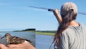
Least Sandpiper Telemetry
Radio telemetry studies of Least Sandpipers were conducted in 2021 and 2022 to estimate residency times and characterize site use for this species (Figure 5). A total of sixty (2021) and eighty (2022) transmitters were deployed on Least Sandpipers between July and August, there were 106 adults and 34 juveniles. The last resight of a tagged individual was on September 13, 2021 and September 1, 2022. This provides evidence for when water management can shift from shorebird to waterfowl management which raises fall water levels to allow access to wetland plant foods to feed migrating waterfowl.
DISCUSSION AND CONCLUSIONS
Lake Red Rock EPM began with experimental water level management in 2016 to 2018 and will continue for the foreseeable future under the new water regulation plan. The EPM adaptive management is suited for a range of flows and operated through a drought in 2022 with excellent outcomes and suitable flow to inundate the delta for fall migrating waterfowl and hunters. The practice is applicable to a subset of dams with specific operating conditions. Neipert et al. (2023) designed an approach for a nationwide, ecoregion spatial analysis of USACE Flood Risk Management dams suitable for EPM. Completing the tool would support a rapid identification and prioritization of projects that can benefit from EPM. It would also support developing regional avian management plans (Jung et al. 2022, Neipert et al. 2023).
Lake Red Rock research is demonstrating that EPM is a cost-effective management practice. Typical costs for large Corps of Engineers restoration construction projects such as island building, river wetland enhancement, backwater dredging coupled with forest plantings, and combinations of features on projects up to 1,000 ha in size on the Upper Mississippi River range from $2,000 - $5,000/ average annual habitat unit (AAHU). Pool scale water level management can improve habitat over thousands of ha and is much more cost-effective at <$1,000/AAHU or much lower for most Upper Mississippi River dams (WLM Regional Coordinating Committee 2022). Pre-project dredging is the only construction activity required, and many only need to be done once to support multiple drawdown events. Water level adjustments are daily operations at most dams and the mode of operating EPM requires the same level of effort but delivers greater environmental benefits that will be documented by our research. The environmental flows planning and implementation also created social benefits by forming the collaboration teams that have
periods.
Federal Threatened State Endangered Piping Plover Piping Plover
Red Knot
Species of Greatest Conservation Need
Blue-winged Teal White-rumped Sandpiper
American Wigeon Buff-breasted Sandpiper
Northern Pintail Pectoral Sandpipier
Redhead Semipalmated sandpiper
Common Gallinule Short-billed Dowitcher
Black-bellied Plover Lesser Yellowlegs
American Golden Plover Wilson’s Phalarope
Hudsonian Godwit Franklin’s Gull
Marbled Godwit Black Tern
Ruddy Turnstone Forster’s Tern
Sanderling American white Pelican
worked together for several years of shared planning and field work that will continue for the foreseeable future.
ACKNOWLEDGEMENTS
Wetland and waterbird, delta elevation characterization, and historic denitrification research was funded by USACE Sustainable Rivers Program.
REFERENCES
Bishop, R.A., J. Joens, and J. Zohrer. 1998. Iowa’s wetlands, present and future with a focus on Prairie potholes. Journal of the Iowa Academy of Science 105: 89-93. Available from https://scholarworks.uni.edu/jias/ vol105/iss3/3
Jung, J.F., R.A. Fischer, C. McConnell, and P. Bates. 2022. The Use of US Army Corps of Engineers Reservoirs as Stopover Sites for the Aransas-Wood Buffalo Population of Whooping Crane. Technical Report ERDC/EL TR-22-8. US Army Corps of Engineers, Engineer Research and Development Center Environmental Laboratory, Vicksburg, MS 30pp. Available from https://apps.dtic.mil/sti/pdfs/AD1176388.pdf
Table 3. Lake Red Rock bird species of conservation need observed during 2021 and 2022 monitoring
Figure 5. Least sandpiper telemetry.
Meulemans, M.J., C.S. Jones, K.E. Schilling, N.C. Young, and L.J. Weber. 2020. Assessment of spatial nitrate patterns in an Eastern Iowa watershed using boat-deployed sensors. Water 12: 146. https://doi. org/10.3390/w12010146
Neipert, E.S., T.E. Steissberg, and C. Theiling. 2023. Spatial Screening for Environmental Pool Management Opportunities. Technical Report ERDC/EL TR-23-9. US Army Corps of Engineers, Engineer Research and Development Center Environmental Laboratory, Vicksburg, MS. Schilling, K.E., E. Anderson, M.T. Streeter, and C. Theiling. 2023. Long-term nitrate-nitrogen reductions in a large flood control reservoir. Journal of Hydrology 620: 129533. https://doi.org/10.1016/j.jhydrol.2023.129533
Stenback, G.A., W.G. Crumpton, and K.E. Schilling. 2014. Nitrate loss in Saylorville Lake Reservoir in Iowa. Journal of Hydrology 513: 1-6. https://doi.org/10.1016/j.jhydrol.2014.03.037
US Army Corps of Engineers – Rock Island District (USACE Rock Island District). 2019. Des Moines River Master Reservoir Regulation Manual Feasibility Report with Integrated Environmental Assessment. U.S. Army Corps of Engineers, Rock Island District, Rock Island, IL. 107 pp. Available from https://hdl.handle.net/11681/39939
Vanausdall, R.A., and S.J. Dinsmore. 2021. Stopover ecology of the least sandpiper (Calidrilis minutilla) in Iowa: Implications for reservoir management. Lake and Reservoir Management 37: 300-312. https://doi. org/10.1080/10402381.2021.1920071
Warner, A.T., L.B. Bach, and J.T. Hickey. 2014. Restoring environmental flows through adaptive reservoir management: planning, science, and implementation through the Sustainable Rivers Project. Hydrological Sciences Journal 59: 3-4, 770-785.https://doi.org/10.1080/02626667.20 13.843777
WLM Regional Coordinating Committee. 2022. Water Level Management Opportunities for Ecosystem Restoration on the Upper Mississippi River and Illinois Waterway: An update to the NESP Environmental Report 53. Upper Mississippi River Basin Association, Bloomington, MN. 40 pp. Available from https://umrba.org/sites/default/files/documents/Water%20Level%20Management%20Opportunities%20for%20 Ecosystem%20Restoration%20on%20the%20UMRS%20-%20July%20 2022.pdf
Floating Treatment Wetland and Biomedia Module for Stormwater Treatment and 6PPD Quinone Removal
Lizbeth Seebacher1, Brianna Pierce2, and Robert Turner1
ABSTRACT
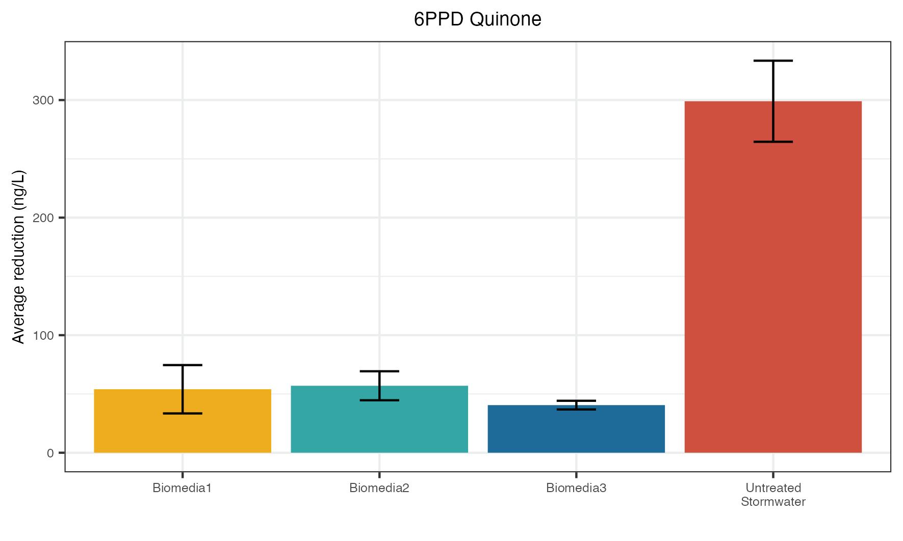
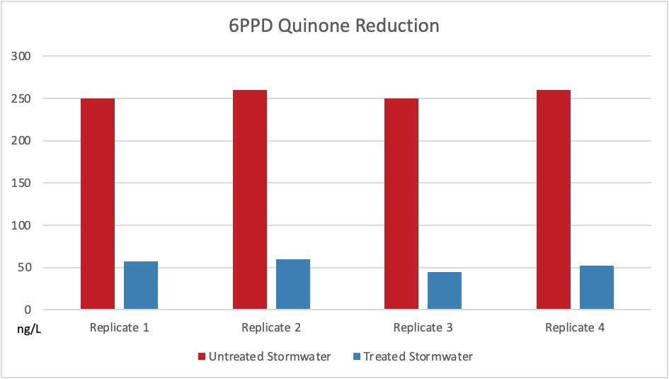
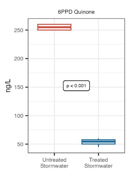
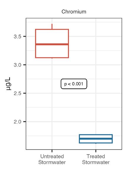
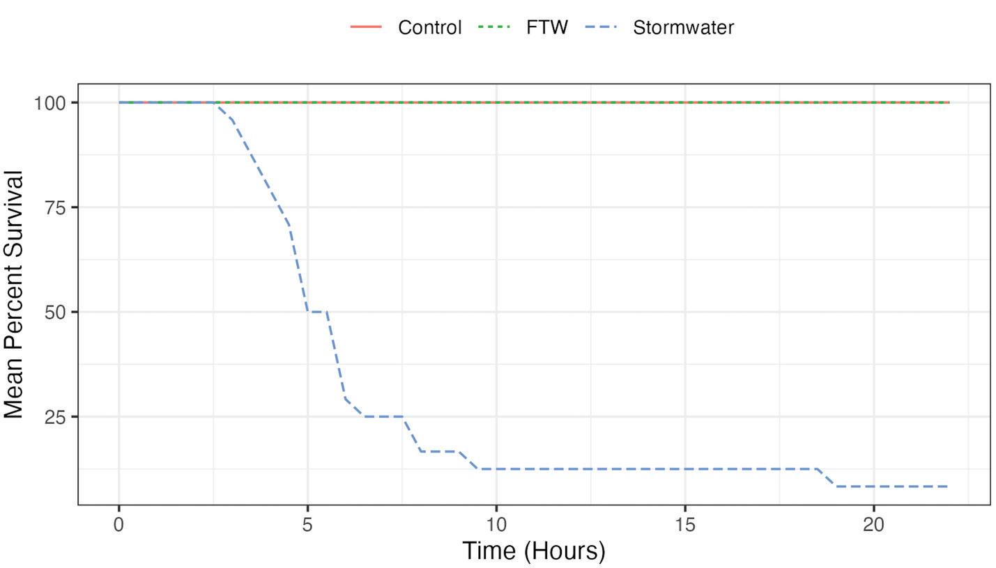
Despite decades of estuarine and river restoration efforts, effectiveness monitoring surveys continue to document premature mortality of coho salmon (Oncorhynchus kisutch) within the streams of urbanized areas in the Pacific Northwest (PNW). Many researchers have identified stormwater inputs, especially road runoff, to be a primary cause of salmon mortality and poor recruitment while other researchers have found that certain stormwater bio-infiltration methods helped reduce mortality significantly. In December of 2020, 6PPD quinone, a previously unknown chemical derived from tire wear particles, was identified as the particularly potent contaminant responsible for killing coho salmon. Traditional biofiltration measures have been shown to alleviate the toxicity of the stormwater on salmon, however, many highly urbanized areas of Puget Sound cannot accommodate bioswales or green infrastructure for the treatment of road runoff before entering urban streams. For these sites where other types of green infrastructure is impractical, using a mesocosm design experiment, we examined the potential of using floating treatment wetlands (FTWs) with biomedia within as an in-situ treatment for stormwater contaminants including 6PDD quinone. We analyzed three biomedia mixes for the ability to adsorb stormwater contaminants, especially 6PPD quinone resulting in reductions of 82%, 81%, and 86% respectively for each biomedia mix tested. We then investigated the efficacy of the most beneficial wetland species planted within FTWs and the most efficient biomedia mix on the reduction of stormwater contaminants (from this point forward including 6PPD quinone) and coho salmon survival. The results were efficacious with a 79% reduction in 6PPD quinone and 100% survival and no symptoms of 6PPD quinone for any of the coho salmon in the treated stormwater. Further deterioration of coho populations risk extinctions within those streams and rivers in high urban environments, reducing overall genetic diversity of the species.
The restoration of habitat in rivers, streams and estuaries has been the focus of land managers and agencies through-
out the Pacific Northwest (PNW) for decades, with hundreds of millions of dollars spent on these efforts. Monitoring surveys of these restoration efforts, researchers noticed an alarming behavior of returning pre-spawn adult coho salmon (Oncorhynchus kisutch) (Scholz et al. 2011). Coho salmon were presenting erratic surface swimming, gaping and loss of equilibrium. The coho died within several hours and females exhibited especially high rates of pre-spawn mortality. After almost a decade of researching water quality conditions, the only connection to the high mortality rates was rain events and urban watersheds (Spromberg et al. 2011).
In one of the first studies, the researchers, now referred to as the Puget Sound Stormwater Science Team (PSSST), exposed healthy coho spawners to: (i) artificial road runoff containing mixtures of metals and petroleum hydrocarbons, at or above concentrations previously measured in urban stormwater; (ii) undiluted road runoff collected from a high traffic roads; and (iii) road runoff pre-treated via bioinfiltration through experimental media columns placed in barrels (McIntyre et al. 2014). The PSSST found that the artificial mixture of contaminants did not cause the mortality syndrome. However, untreated road run-off caused 100% mortality to the coho compared to those coho in the unexposed control tanks. The mortality syndrome was prevented when road run-off was pretreated with green stormwater infrastructure technology. In their experiment run-off was treated by filtration through a biomedia within a large barrel (McIntyre et al. 2015). The media used in that study included a layer of gravel aggregate, 60% sand and 40% compost topped with mulched bark. Due to the success of the treatment, many researchers are now testing numerous stormwater treatment media and infrastructure models in the field (Navickis-Brasch et al. 2022).
Creation of biofiltration swales or ponds to treat stormwater prior to entering water-bodies is not feasible for many waterbodies in highly urbanized areas. The high cost of land in these urbanized areas prohibits construction of stormwater ponds and most urban infrastructure systems allow water to bypass treatment during high flow rain events. In addition, there are countless unmanaged pipes discharging untreated stormwater into the streams and rivers in the Pacific Northwest (Seebacher, personal observation). Together, these factors result in a major limitation and hurdle to urban stream and lake pollution reduction efforts intended to reduce coho mortality. Populations of coho cannot tolerate these high rates of mortality, greater than 50% in many urban streams (Spromberg et al. 2016; McIntyre et al. 2014).
Floating Treatment Wetlands (FTWs) with the treatment biomedia within and underneath, may offer a manage-
ment option for implementation in creeks, streams, lakes or stormwater ponds at the point of stormwater entry (Figure 1). Future FTWs can be designed so that the biomedia is placed within the module while floating, and wetland plants are planted on the top of the module.
Results from a pilot project revealed reduced coho mortality using a biomedia mix recommended by the Washington State Department of Ecology. In order to build upon these results, the goal of this project was to test the efficacy of FTWs and an improved biomedia mix in reducing contaminant loads from stormwater and enhancing the survival of pre-spawn and juvenile coho while also correlating those findings to projected reductions in the impacts of stormwater on other salmonids and aquatic organisms. The term stormwater and road runoff are used interchangeably.
Prior studies have found that FTWs significantly reduce metals and nutrient loads in stormwater (Supplemental Table S1). The use of FTWs for stormwater treatment is to allow for the treatment of stormwater at the point of stormwater entry into waterbodies. This type of green infrastructure can be utilized where the land for stormwater ponds or bioswales are not possible or can be used in addition to other types of treatment. For this project, the contact time is not expected to be sufficient for the uptake by wetland plants, however, we added wetland plants to aid in providing potential habitat for invertebrates and shorebirds as well as to provide a more attractive green infrastructure module in urban environments.
For the pilot project, we tested FTWs planted with wetland plants with a traditional biomedia mix on 135 juvenile
coho salmon. Our initial results demonstrated 31% survival for those coho salmon in the treated stormwater and a mean of 13 hours to death versus 3-4 hours to death and 100% mortality for those unfortunate coho in the untreated stormwater tanks. Following these results, we tested three new biomedia mixes and set of wetland plant species in a mesocosm experiment.
Our specific objectives were to: 1) determine which native wetland plant species perform best with regard to survival in FTW conditions, and 2) determine the most effective biomedia mix for stormwater contaminant and 6PPD quinone removal, then test the chosen wetland species and the most efficacious biomedia mix on stormwater and juvenile coho survival.
By addressing these objectives we hope to attain a BMP biomedia mix, suite of wetland species and FTW design which can reduce stormwater contaminants to levels below which will allow for coho salmon survival. Different site types, such as stormwater ponds, lakes, and streams with direct stormwater entry, will all need a unique FTWbiomedia module design in order to function properly and decrease stormwater contaminants. These designs are the subject of future research.
METHODS
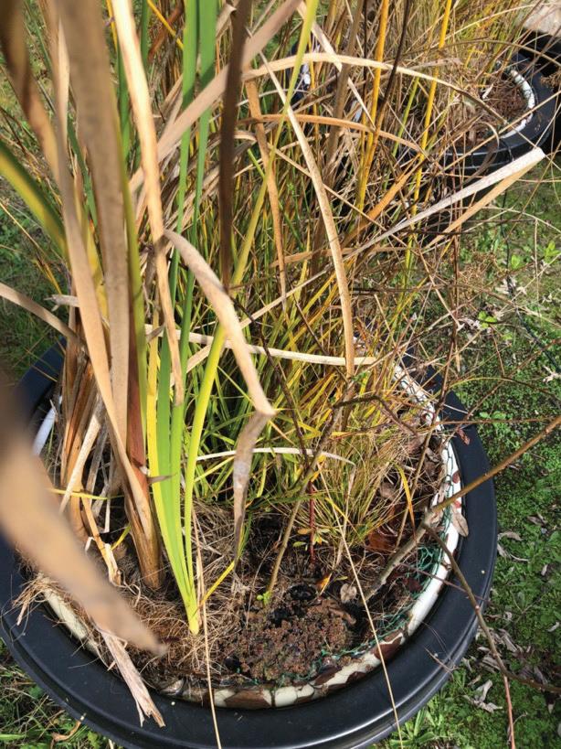
Wetland plant species were chosen based on their facultative wetland indicator ratings. Temporary FTWs were designed and built out of balsa wood, burlap and coconut coir. Wetland species were planted within and placed along the shoreline of Lake Washington within the Union Bay Natural Area (UBNA) at the University of Washington (UW) to
allow them to mature and create a larger root system and introduce a biofilm on the root system. Of the twenty-one species assessed within FTW conditions during the pilot study, fourteen were chosen to continue testing based on ability to survive in the FTW conditions. Of these, 8 were emergent wetland plant species, 2 were woody wetland species, 2 submerged species and 2 floating leaved species. The plants were ordered primarily online in bare root form and planted in the spring of 2020 and allowed to grow through the summer into early fall.
To assess the stormwater contaminant reduction of new biomedia mixes, three new biomedia mixes were chosen for testing on stormwater, based on a literature review of successful use in prior studies. The biomedia mixes in Table 1 were tested for stormwater contaminant removal capabilities. Each media was chosen for specific purposes.
Biochar, wood chips, and coconut coir was included as an organic for adsorption of 6PPD quinone. Past research on biochar imply successful adsorption of metals such as lead, copper, cadmium, chromium and nickel. Additionally, biochar tends to be basic, which can reduce metal mobility (McWayne 2019; Wilfong et al. 2021; Gupta et al. 2020). Organics such as coir, wood chips, and peat moss have the ability to remove heavy metals via ion exchange and include humic substances, cellulose, and lignin that have been shown to bind metals via surface complexation as well as ion exchange (Lim et al. 2015; Trenouth and Gharabaghi 2015; Ho et al. 2000; McWayne 2021). Leca clay Filtralite NR (2-4 mm balls) was included for nutrient adsorption to keep TN and TP levels potentially leached from the organic material in check. Sphagnum peat moss was included as an organic with a positive charge due to the hydrogen atoms on the surface, which would attract 6PPD quinone which has a slight negative charge (McWayne 2021). At the time of this experiment, the contaminant killing coho salmon was now known. The research and resulting journal article on 6PPD quinone was published in December of 2020 (Tian et al. 2020).
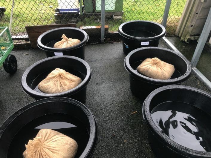
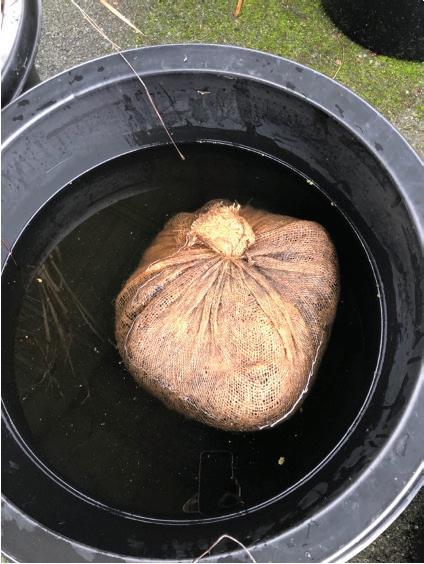
Replicate samples (n=4) of biomedia was placed within a wrap of burlap fabric in order to keep the biomedia from floating or sinking in the tank (Figure 2). In spring of 2021, stormwater was collected from the same major arterial highway in Tacoma, Washington and transferred immediately to the UW. Fifteen gallons of stormwater were placed into cleaned and sterilized twenty-gallon HDPE tanks. The tanks were randomly assigned a biomedia mix treatment or labeled as a control tank (stormwater left untreated). Small pumps were placed in each tank to circulate the water.
After 24 hours, the biomedia bags were removed, and water samples were collected from the center of the tank using sterile glass bottles provided by the laboratory and placed in a cooler with ice packs. The samples were transported immediately to the Center for Urban Waters laboratory in Tacoma, WA for 6PPD quinone analysis in sterilized amber glass 20 ounce bottles, and to the Eurofin
Table 1. Three biomedia mixes with five to six media were tested for stormwater contaminant reduction with a focus on 6PPD quinone.
Figure 2. Field design for biomedia mesocosm experiment. Each of the three biomedia mixes were placed in a 20 gallon container with stormwater for 24 hours, control tanks were untreated stormwater (lower right). (Photo credit: Lizbeth Seebacher)
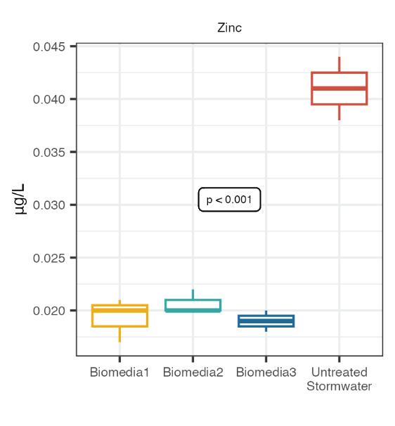
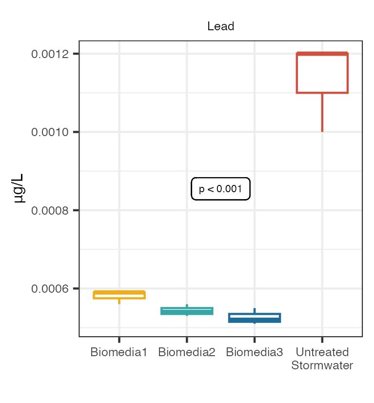
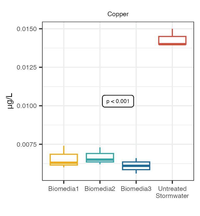
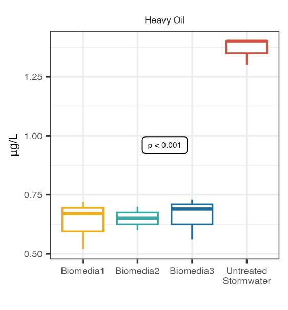
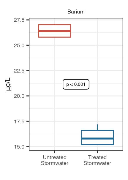
Laboratory in Tacoma, Washington, a lab accredited by the state’s regulatory agency, the Department of Ecology for the following analytes (pH, DO, CaCO3, Br, Mg, Al, Sb, Ar, Ba, Be, Cd, Cr, Co, Cu, Pb, Mn, Mo, Ni, Se, Ag, TI, V, Z, Diesel and Heavy Oil)
To evaluate the stormwater contaminant reduction of the chosen wetland plant species and best performing biomedia mix on coho salmon survival, the wetland plants were grown in new temporary FTWs within lake water from Lake Washington throughout the summer of 2021 to mature and develop a large root system. Just prior to the experiment in the fall of 2021, biochar and Leca clay balls were rinsed well with distilled water and dried before combining with the other biomedia within burlap fabric. All equipment was disinfected with an iodine solution. Stormwater was collected from the same location near the City of Tacoma immediately after a rain event and taken to the UW where we placed 45.5 liters of stormwater into each of the twenty-gallon tanks (75.71 liters). Replicate tanks (n=4) were then randomly assigned to be treated stormwater or untreated. The stormwater was “treated” for 24 hours with an FTW with an estimated root mass of 25% of the tank and ten liters of biomedia floating underneath (Figure 3).
At +20 hours in the experiment, we acquired ~90 juvenile coho from the Puyallup tribal hatchery and transported the coho to the UW. After the 24-hour treatment, the FTWs and biomedia were removed and the treated and untreated stormwater was moved to ten-gallon fish tanks, control tanks included hatchery water, each with a pump and bubbler. Six juvenile coho were then randomly placed within each of the fish tanks and exposed for 22 hours.
The water quality was monitored every hour for temperature, dissolved oxygen (DO), and pH to make sure that all tanks remained within the range that fishery biologist suggested for juvenile coho. We also strived to match the hatchery water temperature (11º C). The temperature ranged from 11.4º C to 14.7º C, DO ranged from 6.5 to 10.3 mg/L and pH from 6.6 to 7.4 through the duration of the experiment within all tanks (treated stormwater, untreated stormwater and control). We monitored fish survival and behavior (fin splaying equilibrium, mouth gaping, surface swimming) every half hour for two minutes per tank for treated, untreated tanks, and control tanks.
After the 22-hour exposure, the fish were removed from the fish tanks. The surviving fish from the treated tanks were humanely euthanized with MS222 as required
Figure 3. Biomedia mix #3 was placed under (left photo) a floating treatment wetland with selected wetland plants placed on top (right photo). Stormwater treatment = 24 hours. (Photo credit: Lizbeth Seebacher)
by our permit from the Washington Department of Fish and Wildlife (WDFW) and Office of Animal Welfare at the University of Washington. The fish from the control tanks (hatchery water) were returned to the Puyallup Hatchery as permitted by the WDFW.
Following fish removal, water samples were taken from the middle of each tank and analyzed for the following stormwaer contaminants (CaCO3, 6PPD Quinone, Br, Ca, Mg, Al, Sb, Ar, Ba, Be, Cd, Cr, Co, Cu, Pb, Mn, Mo, Ni, and Ag).
STATISTICAL ANALYSIS
The second objective was to compare three different biomedia mixes treatments on stormwater contaminant removal. A One-Way ANOVA was performed to test if the mean levels of contaminants are the same in each of the three treatments and untreated stormwater. Rejecting a hypothesis indicates that at least two groups have different means. The p-values were adjusted for multiple comparisons using a Bonferroni correction. A post-hoc analysis using Tukey’s Honestly Significant difference test was performed to compare averages of each treatment with untreated stormwater.
RESULTS
The wetland plant species listed in Table 2 were grown in temporary FTWs in order to determine their ability to survive in the partially to fully submerged conditions of floating treatment wetlands. Six species were chosen for use in the next phases of the project.
The second objective of the study was to determine the most effective biomedia mix for stormwater contaminant and 6PPD quinone removal and then test the chosen wetland species and the most efficient biomedia treatment mix on stormwater and juvenile coho survival.
The three biomedia performed similarly to each other in reducing five significant stormwater contaminants (Figure 4). One-way ANOVA showed significant reductions in zinc (p = <0.001), lead (p = <0.001), copper (p = <0.001), and heavy oil (p = <0.001) and 6PPD quinone (p = <0.001) within the treated stormwater relative to the untreated stormwater. On average, the Biomedia #3 mix provided an 86% reduction in 6PPD quinone.
Wetland Plant Species
Eleocharis acicularis
Schoenoplectus tabermaemontanii±
Juncus effusus±
Typha latifolia±
Azolla filiculoides
Bouteloua curtipendula
Salix sitchensis
Plant performance in FTW conditions
Very difficult to grow – discontinued
Especially easy to grow from rhizomes
Easy to grow from rhizomes, very hardy
Easy to grow from rhizomes, very hardy
Can be too aggressive, not found in streams
Difficult to grow
Easy to propagate, but too large for test FTWs
Elymus canadensis (glaucus) ± Difficult to grow in FTWs, changed to glaucus
Ceratophyllum demersum
Leersia oryzoides±
Deschampsia caespitosa±
Elodea canadensis
Populus deltoides
Lemna minor
Not found in streams, only in lake systems
Dense root system, favorable growth in FTWs
Relatively easy to grow, difficult to find locally
Difficult to find locally, does not grow well in tanks
Too large for current FTW design
Difficult to grow, not found in streams
± Included in FTW – Biomedia modules for coho salmon survivorship study.
Table 2. Feasibility of wetland plants species for use in FTWs.
Figure 4. Biomedia mix study lab analysis results. Each box in the plots indicates the 1st and 3rd quantile and median, the whiskers indicate the interquantile range up to the minimum and maximum value. The p-values noted via a one-way ANOVA testing the difference between all four groups. Stormwater was treated for 24 hours.
Figure 4 indicates the results for each of the three biomedia, from the lab analysis for zinc, lead, copper, heavy oil and 6PPD quinone when compared to the untreated stormwater.
Figure 5 provides the results of the biomedia experiment for 6PPD quinone analysis. There is a significant contaminant reduction with biomedia versus untreated stormwater. (ANoVA, F(3,8)=71.8, p<0.001) Biomedia mix #3 was the most consistent and on average performed best on 6PPD quinone reduction with a mean of 40.5 ng/L versus 54 ng/L for Biomedia mix #1, 57 ng/L for Biomedia mix #2 and 299 ng/L 6PPD quinone for the untreated stormwater.
Appendix 1 presents the lab analysis results for all stormwater contaminants tested.
After determining the best performing wetland species with regard to survival in FTW conditions and most successful biomedia mix for stormwater contaminant removal, these species and biomedia mix (biomedia mix #3) were tested for coho survival and stormwater contaminant reduction.
The results from this experiment provided a signicant reduction (ANoVA, F(1,6)=2127.63, p<0.001) of 79% of the newly discovered contaminant, 6PPD quinone (Figure 6) from a mean of 255 ng/L to a mean of 53 ng/L, a one
Figure 5. 6PPD quinone reduction for each biomedia mix compared to untreated stormwater. Results in nanograms per liter (ng/L). Stormwater was treated for 24 hours.
Figure 6. 6PPD quinone reduction in treated vs. untreated stormwater. Results in nanograms per liter (ng/L).
Figure 8. Time to death for Coho in treated and untreated stormwater. This line graph shows the time to death for the Coho in the untreated stormwater. The top line, or 100% survival included all treated tanks and control tanks (six fish in each tank – four replicate tanks for the treated and untreated stormwater and control tanks)
way ANoVA, F(1,6), p<0.001. Other significant stormwater contaminant reductions included Barium and Chromium (Figure 7). Appendix 2 presents the lab analysis results for all stormwater contaminants tested in the FTW/Biomedia mix experiment on coho salmon
The coho in the four replicate untreated tanks began to show symptoms in hour two and the first death was in hour three. Symptoms included: loss of equilibrium, mouth gaping, loss of buoyancy, and sinking. As Figure 8 indicates, within hour four, five of the 24 (six fish per tank, four replicate tanks) coho were dead and by the fifth hour, half of the 24 coho had died. By the sixth hour of exposure,
only four of the 24 coho survived but succumbed by the 8th hour except for the two fish that survived the full 22-hour experiment.
CONCLUSION
This research project is one of the first to report specific reductions in 6PPD quinone via in situ treatment of stormwater. No other published work to date contains 6PPD quinone reduction analysis, along with coho (Oncorhynchus kisutch) survival data.
This mesocosm experiment has allowed us to ascertain the most effective biomedia mix of the mixes we examined for 6PPD quinone reduction with the least amount
Figure 7. Stormwater contaminants with significant reduction in treated vs. untreated stormwater.
Treated stormwater — 100% Survival
Untreated stormwater
of leaching of metals and nutrients. We will not be able to experience 24 hours of contact time of the stormwater with the biomedia in the field, however, the next phase of this project will test different FTW/Biomedia module designs at several field sites to determine the ratio of biomedia to stormwater and contact time necessary to reduce 6PPD qunione significantly for practical application.
The results from this research correspond with the results found by the Puget Sound Stormwater Science Team (PSSST) for coho mortality and time to death when exposed to direct road runoff. The first coho began showing symptoms of 6PPD quinone toxicity in hour two, and the first death was in hour three. It has since been discovered that the new stormwater collection site under the offramp of Interstate 5 is slightly “weaker” for stormwater contaminants, including 6PPD quinone. The amount of traffic on the offramp during our sampling period was not as high as expected.
Per Tian and others (2020, 2022) coho salmon are especially sensitive to 6PPD quinone (2-anilino-5-(4-methylpentan-2-yl)amino)cyclohexa-2,5-diene-1,4-dione). In the 2022 revised toxicity paper, the authors include a table where 6PPD quinone is listed as the second most toxic chemical with the most sensitive species O. kisutch (coho salmon) and an LC50 of 0.10 ppb. According to the Tian, et.al, 2020, the PSSST had determined that the LC50 of coho was 0.8 ug/L or 800 ng/L, however, based on updated research results (Tian et al. 2022), the revised toxicity assessment is now LC50 of 100 ng/L (80-100 ng/L with a 95% confidence level).
Indisputably, coho salmon populations cannot withstand the mortality rates they are currently suffering within urban watersheds in western Washington. Until the source of this contaminant can be eliminated, effective treatment of our surface water will not be possible. The biomedia tested in our mesocosm study resulted in 100% survival and no 6PPD quinone symptoms. The 6PPD quinone was reduced by 79% in the mesocosm study from a mean of 255 ng/L to 53 ng/L allowing for 100% survival of coho within the treated stormwater. Can this experimental approach be applied for real world applications – that is the next step.
By utilizing the Floating Treatment Wetland/Biomedia module, we are able to place the biomedia directly into the receiving water body at the location of stormwater entry to remove or reduce contaminant load in stormwater. This “in situ” method of stormwater treatment should not take place of other Green Infrastructure devices, but be available for those sites that do not allow for the typical Green Infrastructure methods, such as bioswales or stormwater ponds or they can be used in conjunction with other approaches to improve efficacy. Improved treatment of stormwater is necessary to increase survival of pre-spawn and juvenile coho and to reduce the impacts of stormwater on other salmonids and aquatic organisms.
ACKNOWLEDGEMENTS
We would like to thank our funders, the King County Council members and the King County Waterworks Program. Thank you to the following individuals and researchers for their assistance with this project: Galen Fulford (Biomatrix Water), Brianna Pierce (Field Assistant), Roman Koltonowski (Field Assistant) Jill Wetzel (PSSST), Blake Smith (Puyallup Hatchery), Rob Turner (UW), Julian Olden (UW), Leena Perera (UW), Don McQuilliams (City of Bellevue), Gabriela Vasconcelos (Statistician, UW) and especially Lauren Kuehne (UW) for her assistance with this publication.
REFERENCES
Gupta, S., S. Sireesha, I. Sreedhar, C. M. Patel and K.L. Anitha. 2020. Latest trends in heavy metal removal from wastewater by biochar based sorbents. JWPE. 38: doi:10.1016/j.jwpe.2020.101561.
Ho, Y.S., G. McKay, D.A.J. Wase and C.F. Forster. 2000. Study of the Sorption of Divalent Metal Ions on to Peat. Adsorpt. Sci. Technol. 18: 639–650. doi:10.1260/0263617001493693.
Lim, H.S., W. Lim, J.Y. Hu, A. Ziegler and S.L. Ong. 2015. Comparison of filter media materials for heavy metal removal from urban stormwater runoff using biofiltration systems. J. Environ. Manage. 147: 24–33. doi:10.1016/j.jenvman.2014.04.042.
McIntyre, J.K., J.W. Davis, J.P. Incardona, J.D. Stark, B.F. Anulacion and N.L. Scholz. 2014. Zebrafish and clean water technology: Assessing soil bioretention as a protective treatment for toxic urban runoff. Sci. Total Environ. 500-501:173–180. doi:10.1016/j.scitotenv.2014.08.066.
McIntyre, J.K., J.W. Davis, C. Hinman, K.H. Macneale, B.F. Anulacion, N.L. Scholz and J.D. Stark. 2015. Soil bioretention protects juvenile salmon and their prey from the toxic impacts of urban stormwater runoff. Chemosphere. 132: 213–219. doi:10.1016/j.chemosphere.2014.12.052.
McWayne, E. 2019. Stormwater Pollutant Chemistry, Monitoring, and BMP Effectiveness. April 16-17, 2019, National Environmental Management Academy, LLC. Stormwater Pollutant Course.
McWayne, E. 2021. Personal communications.
Navickis-Brasch, A.S., M. Maurer, T. Hoffman-Ballard, S. Bator and J. Diamond. 2022. Stormwater Treatment of Tire Contaminants. Best Management Practices. Final Report, June 2022. For: Washington State Department of Ecology. https://fortress.wa.gov/ecy/ezshare/wq/Permits/ Flare/2019SWMMWW/Content/Resources/DocsForDownload
Scholz, N.L., M.S. Myers, S.G. McCarthy, J.S. Labenia, J.K. McIntyre, G.M. Ylitalo, L.D. Rhodes, C.A. Laetz, C.M. Stehr and B.L. French. 2011. Recurrent Die-Offs of Adult Coho Salmon Returning to Spawn in Puget Sound Lowland Urban Streams. PloS One. 6(12): e28013–. doi:10.1371/journal.pone.0028013.
Spromberg, J.A. and N.L. Scholz. 2011. Estimating the future decline of wild coho salmon populations resulting from early spawner die-offs in urbanizing watersheds of the Pacific Northwest, USA. Integrated Environmental Assessment and Management. 7(4):648–656. doi:10.1002/ ieam.219.
Spromberg, J.A., D.H. Baldwin, S.E. Damm, J.K. McIntyre, M. Huff, C.A. Sloan, B.F. Bernadita, J.W. Davis and N.L. Scholz. 2016. Coho salmon spawner mortality in western US urban watersheds: bioinfiltration prevents lethal storm water impacts. Journal of Applied Ecology. 53: 398-407.
Tian, Z., H. Zhao, K.T. Peter, M. Gonzalez, J. Wetzel, C. Wu, X. Hu, J. Prat, E. Mudrock and R. Hettinger R. 2021. A ubiquitous tire rubber-derived chemical induces acute mortality in coho salmon. Science (AAAS). 371(6525):185–189. doi:10.1126/science.abd6951.
Tian, Z., M. Gonzalez, C.A. Rideout, H.N. Zhao, X. Hu, J. Wetzel, E. Mudrock, C.A. James, J.K. McIntyre and E.P. Kolodziej. 2022. 6PPD-Quinone: Revised Toxicity Assessment and Quantification with a Commercial Standard. Environ. Sci. 9(2):140–146. doi:10.1021/acs. estlett.1c00910.
Trenouth, W.R. and B. Gharabaghi. 2015. Soil amendments for heavy metals removal from stormwater runoff discharging to environmentally sensitive areas. J. Hydrol. (Amsterdam) 529:1478–1487. doi:10.1016/j. jhydrol.2015.08.034.
Wilfong, M.T., R.E. Casey and D.R. Ownby. 2021. Performance of commercially available soil amendments for enhanced Cu attenuation in bioretention media. J. Environ. Manage. 295:113047–113047. doi:10.1016/j.jenvman.2021.113047.
APPENDIX 1
Stormwater contaminant lab results for biomedia mix experiment after 24 hours of treatment.
Stormwater contaminant lab results for FTW/Biomedia Mix on Coho experiment after 24 hours of treatment.
The Use of Wetlands by Fishermen in the Region of the Lower Papaloapan River Basin (Veracruz, Mexico)
Blanca Edith Escamilla Pérez1, Martha Judith Hernández Velasco2, Xochitl del A. León Estrada1, and Hugo López Rosas1*
ABSTRACT
The inhabitants of the Papaloapan River’s lower basin have been devising strategies for adjusting to nature since prehistoric times, utilizing the diverse species found in the wetlands. Currently, commercial fishing is an economic activity that has been developed throughout the lagoon system (Alvarado Lagoon System, ALS). In areas with less saline influence, sugar cane is grown, and extensive livestock farming is practiced. Moreover, for local consumption and trade, freshwater turtles and blue crabs (Cardisoma guanhumi) are caught. Additionally, the “naca” fish (Dormitator maculatus) is obtained for a brief period during the rainy. Human activity has had a negative impact on the wetland complex and the species that inhabit them, due to factors such as agricultural expansion, the extraction of species, and water pollution. Through our field activities, we observed that the population living along the lower basin of the Papaloapan River has developed a symbiotic relationship with the river, which has permeated their daily life, traditions, and festivities. Despite the recognition of the wetlands as a Ramsar site, the degradation of the ecosystem has not been halted. Therefore, it is imperative to develop alternative strategies aimed at safeguarding and conserving it.
INTRODUCTION
In the lower basin of the Papaloapan River (Veracruz, Mexico), there is a complex set of wetlands, rivers, and coastal lagoons known as the Alvarado Lagoon System (ALS). This system covers more than 314,000 hectares. This wetland complex is the third largest in Mexico and has the largest area of mangrove in the state of Veracruz. It is also the second largest in the Gulf of Mexico (RodríguezLuna et al. 2011). Additionally, the system includes other freshwater wetlands, such as marshes, flooded palm groves, flooded forests, sandy beaches, and coastal dunes. In the ALS, there also exist livestock and farming systems, mainly consisting of flooded pastures for cattle and sugar cane plantations. Due to its significance, it has been designated as a Ramsar site since 2004 (Ramsar site 1355, Sistema Lagunar de Alvarado, https://rsis.ramsar.org/es/ris/1355). The extensive surface area of wetlands allows for a high
diversity of aquatic fauna, especially birds. It is estimated that the system serves as a habitat for more than 300 species of birds, both resident and migratory (Berlanga et al. 2008), as it is situated within the Central Flyway. This is why the Important Bird Area ‘Humedales de Alvarado’ is also located within this system (BirdLife International 2023). The ALS also serves as the habitat for the threatened manatee (Trichechus manatus) and a diverse range of species that are exploited commercially or locally, including the blue crab (Cardisoma guanhumi), the fat sleeper (Dormitator maculatus, locally referred to as naca), and seven species of freshwater turtles, all of which are deemed threatened species by the NOM-059-SEMARNAT-2010 in Mexico (Cázares Hernández 2015). The region’s wetlands have been used by people since pre-Hispanic times. Despite having distinct categories of biological conservation, the ALS nonetheless exhibits significant impacts due to the alteration in land use within the basin, hydraulic works such as dams, industrial activities, oil, agricultural and livestock activities, among other factors. In this article, we will document the natural history of the region, the records of the historical use of its wetlands, their current use, and the environmental problems in the area.
THE PAPALOAPAN RIVER BASIN
Because of its size (47,600.51 km2), the Papaloapan River Basin (PRB) is the second-largest hydrological system in Mexico (Andrade Galindo and González Solano 2003; Figure 1). The upper zone of the basin (130 – 160 km from the coast) is located mainly in the north of the state of Oaxaca (Sierra Juárez), where it reaches an altitude of 2,970 meters a.s.l. Additionally, it includes an eastern portion of the state of Puebla, at an altitude of 2,619 meters a.s.l. This region is located between 130 and 160 km from the coastal zone and receives rainfall almost all year round, with annual accumulations greater than 3000 mm of rain or fog (CNA 1992; García 1987). The geomorphology of this mountain area has an abrupt descent, since the plain is located at a distance of between 20 and 30 km from the ridge tops. The two dams, “Miguel Alemán” (also known as the “Temascal” dam, in 1959) and “Miguel de la Madrid” (also known as the “Cerro de Oro” dam, in 1988), were constructed at elevations ranging from 50 to 150 meters above sea level, at a distance of between 100 and 120 km from the coastal area. From here, an extensive plain is formed that borders the Papaloapan River and its tributaries. Approximately one third of the basin corresponds to low areas of the coastal plain. This basin contains a potential water reserve equivalent to 18.9% of the country’s total potential reserves. This basin receives the 12% of Mexico’s total precipitation, making it one of the most significant freshwater re-
1 Academia de Desarrollo Regional Sustentable, El Colegio de Veracruz, Carrillo Puerto 26, Zona Centro, Xalapa, 91000, Veracruz, Mexico.
2 Facultad de Antropología, Universidad Veracruzana, Francisco Moreno S/N, Col. Francisco Ferrer Guardia, Xalapa, 91026, Veracruz, Mexico
the delimitation of the Papaloapan River
and its
serves in the country (CNA 2011). Due to the large amount of water that flows down the basin, a complex system of coastal lagoons, rivers, and wetlands formed on the coastal plain of the ALS. This is an intertidal system of freshwater and brackish environments, that supports a high diversity of aquatic fauna.
The Alvarado Lagoon System (ALS)
The ALS contains the second-largest area of mangrove in the Gulf of Mexico. The mangrove covers close to 20% of the total surface of the area. The species are red mangrove (Rhizophora mangle), white mangrove (Laguncularia racemosa), and black mangrove (Avicennia germinans). In brackish or freshwater environments, large surfaces are formed with marshes dominated by cattail (Typha domingensis), reed (Phragmites australis), alligator flag (Thalia geniculata), Mexican papyrus (Cyperus giganteus), or spike-rushes (Eleocharis spp.) (Figure 2). There are still remnants of flooded forests dominated by money tree (Pachira aquatica) or flooded groves dominated by Mexican sabal palm (Sabal mexicana) (Rodríguez-Luna et al. 2011). Large areas of wetlands have been replaced by grasses of African origin, such as Pará grass (Brachiaria mutica) or Antelope grass (Echinochloa pyramidalis) (López Rosas et al. 2013).
Figure 2. Example of an oligohaline marsh dominated by a spike-rush Eleocharis sp. An isolated seedling of white mangrove (Laguncularia racemosa) is observed. The mangrove community mixed with palms of Sabal mexicana can be seen in the background. (Photo by Adrián López Espejel)
Figure 1. Map showing
Basin (PRB)
location in the states of Veracruz, Puebla and Oaxaca in Mexico (Elaborated by Roberto C. Monroy Ibarra).
This large area of wetlands is a priority site for bird conservation. A total of 337 bird species have been recorded, which corresponds to 32.6% of the bird species found in the country. Migratory birds are important in these systems; they constitute 49% of the total recorded for the area. Out of this, 45 are classified as being at some risk per the established Mexican Official Norm (Berlanga et al. 2008; Portilla-Ochoa 2003).
HISTORICAL USE OF WETLANDS
In ancient Mesoamerica, the use of wetlands has a long cultural history. The Olmec people in the Coatzacoalcos River floodplain, temporarily cut off from other towns due to river fluctuations, developed community improvement strategies. Wetland use reflected risk management and adaptation, granting resource control vital for survival (Cyphers et al. 2013). In the Central Altiplano, evidence shows wetlands utilization in hunting, fishing plant collection, and craft (Sugiura and Serra Puche 1983). In western Mexico, pre-Spanish, commercial exchange via water routes aided the Purépecha Empire’s development (Williams 2015). Wetlands offered abundant nutrition, including algae, insects, fish, plants, reptiles, and birds (Parsons 2005; Sugiura 2015; VanDerwarker 2006; Williams 2009). They remain integral to cultural identity, seen in Xochimilco’s chinampas (a pre-Hispanic cultivation system comprised the placement of wooden stakes around a raft-shaped islet), and Mexica Empire founding myths in Lake Texcoco.
One of the most relevant wetland landscapes since pre-Hispanic times up to the present is the lower basin of the Papaloapan River. This culturally multi-ethnic region has evidence of human occupation and settlement dating back to the Mesoamerican Formative Period (1200 BC to 200 AD) (Medellín 1960; Stark 1989), highlighting its long history of human use.
In 1908, Leopoldo Batres published “Prehistoric Civilization of the Banks of the Papaloapan and Sotavento Coast.” This work highlights the strategic geographic location that facilitated interaction between settlements both inside and outside the basin. The basin’s geographic location and water communication networks drove population movements, migrations, and the creation of new settlements, fostering trade. During the 1940s, Gonzalo Aguirre Beltrán described the colonization of human settlements like La Campana, El Tiesto, El Zapotal, El Cocuite, La Mojarra, and Tío Primo. He emphasized the ecological conditions of the Papaloapan and referred to this region as La Hoya (The Hollow) due to its basin-like geographical characteristics (Ortiz 1987). Since the late 20th Century, this region has been studied by both foreign and domestic researchers, expanding our understanding of the lifestyles of communities settled in flood-prone areas and their relationship with water (Guadarrama Olivera 2005, Pool et al. 2023, Velasco Toro and Ramos Pérez 2011).
settlements
located in wetlands in Costa de San
Stark and Ossa (2005) consider that the mounds were intended for residential use. During the flood season, the dwelling was safeguarded, and upon the receding of the flood, the low areas were utilized as orchards. (Photo by Hugo López Rosas)
Some of the present-day villages along the banks of the Papaloapan River are built upon ancient settlements, strategically positioned to foster cultural continuity and showcase the ongoing use of the river and wetlands. For instance, archaeological studies of sites near the river in the Tlacojalpan and Otatitlán areas during the Classic Period (200-900 AD) have discovered obsidian utensils used for fish scaling (Jiménez Lara y León Estrada 2010). Towards Tlacotalpan and Alvarado, there’s significant importance noted in the river networks, coastal dunes, and wetlands for fishing associated with mangroves (Stark 2008). Aquatic resources in the ALS were highly valued because the scarcity of arable land meant ancient inhabitants of the mangroves subsisted on them. Evidence indicates that, since pre-Hispanic times, these floodplains were transformed for human settlements, as mounds of rammed earth from that period can still be observed (Figure 3).
The PRB holds significant importance in Mesoamerican cultural history due to the La Mojarra stele, a monolith found on the banks of the Acula River, which feeds into the Alvarado lagoon (Diehl 2011). This area, characterized by compacted earth mounds amid waters and bordered by mangroves, is notable for the stele, which, according to Justeson and Kaufman (2008) represents one of the oldest pieces of evidence of glyphic writing in Mesoamerica, featuring a historical narrative in a pre-Protozoque language.
During the Postclassic period (900-1521 AD), the lower PRB was part of the Tochtepetl province (Aguirre Beltrán 1992), which paid tribute to the Mexica Empire with cotton blankets, diverse fish, and multicolored birds, showcasing the region’s biodiversity of the region, as documented in the Mendoza Codex. Subsequently, the Spanish explored
Figure 3. The remains of pre-Hispanic
are represented by mounds
Juan, Alvarado (Veracruz).
the area by both water and land. According to Bernal Díaz del Castillo’s account, 500 years ago, Captain Pedro de Alvarado ventured through a river known to the indigenous people as Papaloapa, where abundant fish products were found. He also narrates an encounter with indigenous fishermen who claimed to be “natives of a town called Tacotalpa” (Díaz del Castillo 1974: 22). During the colonial era in the 16th century, fisheries were established. Fishing became a traditional activity among the indigenous population, Spanish settlers, mulattoes, and mestizos (Velasco 2003: 127). However, gradually, cattle farming became a more important than fishing (Thiébaut 2013).
The natural and cultural characteristics of the wetland landscape in the lower basin of the Papaloapan River are also reflected in common language. Papaloapan derives from the Nahuatl words papalotl (butterfly) and apan (river), meaning “river of the butterflies”; while Tlacotalpan, one of the main cities in the lower Papaloapan basin, owes its name to the Nahuatl words tlacotl (reed, rod), tlalli (land), and pan (on top of...) (Thouvenot 2014); thus, it would literally translate to a place of reeds on the land or green rods on the land. This refers to the characteristic cattail (Typha domingensis) formations, that grow along the riverbanks. Another example is Otatitlán, a village situated on the banks of the Papaloapan River. In Nahuatl, Otatitlán is derived from otatl (giant cane), ti (under), tlan (place), translating to “place under the giant canes” (Melgarejo Vivanco 1950:30), which refers to the bamboo-like plants of the Otatea genus growing along the riverbanks, streams, and commonly found in wetland areas.
Through the historical utilization of wetlands, we can observe how it refers to an ecosystem and encompasses “an
entire social fabric and the implications that come with its occupation and use (...) within a cultural context in which the ecosystem is just one influential part that enables symbiotic relationships” (León Estrada and Wilson 2020:188).
CURRENT USE OF WETLANDS
There are multiple activities in the lower basin of the Papaloapan River contributing to its economic progress, spanning across a salinity gradient from the intertidal zone to areas without saline influence. Commercial fishing is conducted throughout the lagoon system, including the river and streams. In areas with lower saline influence, the primary economic activity is agriculture, primarily focused on sugarcane cultivation, followed by extensive cattle farming (Figure 4). Traditionally, for local consumption and trade, freshwater turtles and blue crabs (Cardisoma guanhumi) are harvested. Turtles are captured in the wetlands, primarily during the dry season when they are estivating; turtle hunters set fires to force the turtles out of the mud. Meanwhile, the capture of blue crabs mainly occurs during the rainy season, when females migrate from the wetlands to the sea for spawning (Figure 5). Another less commercial fishing activity is for the “naca” fish (Dormitator maculatus), occurring only for a few days during the rainy season (September-October) when females migrate along the river, from freshwater wetlands to saline environments. This is a massive migration in which many specimens can be caught quickly, which is not possible during the dry season, when this species is estivating in the mud. It is also difficult to catch outside of migration because the fishes are dispersed in the wetlands, where they are difficult to catch. All these activities have had negative impacts on the wetland com-
Figure 4. In the ALS, large areas of freshwater and oligohaline wetlands have been displaced by grasslands, with exotic grasses, for the practice of extensive cattle ranching. In the process of land use change, ranchers first burn native wetland vegetation to later plant forage grasses. (Photo by Hugo López Rosas)
Figure 5. In the rainy season, from July to September, female blue crabs (Cardisoma guanhumi) migrate from the freshwater and oligohaline wetlands to the beaches to spawn in the sea. On their migratory route, many specimens are captured for human consumption before they can spawn. (Photo by Verónica E. Espejel González)
plex and the populations of these aquatic species. More recently, mangrove reforestation activities have been practiced (Figure 6), along with beekeeping (Figure 7), producing mangrove honey (a blend of pollen from Laguncularia racemosa, Rhizophora mangle, and Avicennia germinans) and “estribo” honey from Brown’s indian rosewood (Dalbergia brownei), a legume woody shrub or vine inhabiting riverbanks and freshwater channels.
The PRB is also one of the main agricultural production centers in Veracruz, primarily for sugarcane, but for maize, tropical fruits, and vegetables in non-flood zones. It stands as Mexico’s most significant sugarcane-producing region, with 10% of the national land devoted to this crop situated within this basin (CONADESUCA 2023). Due to the high demand for sugar and the maintenance of prices, the area allocated for sugarcane cultivation increases annually, leading to changes in land use or the replacement of other crops with lower demand. This situation negatively impacts wetlands as they increasingly receive excess residues of fertilizers and pesticides.
Extensive cattle farming also has a major impact on wetlands as vast expanses of mostly freshwater wetland have been replaced by flooding grasslands featuring exotic grass species originating from Asia and Africa (López Rosas et al. 2013). This pattern repeats in other flood-prone areas in southern and southeastern Mexico. However, in the Papaloapan basin, since 1970, cattle production has exceeded the national average (Rodríguez-Luna et al. 2011). This pattern of land use change to allocate land for extensive cattle ranching persisted for more than 30 years, and by 2003, this activity already occupied 50% of the lower basin. In the past 20 years, due to low cattle ranching pro-
Figure 6. Farmers in field with planted mangroves. In the last decade, the National Forestry Commission of Mexico has promoted the Environmental Compensation Program due to change of land use in forest land. Small landowners, farmers of communal lands or fishermen, from the Alvarado Lagoon System have benefited from this program, with economic incentives for mangrove reforestation. (Photo by Ignacio C. Sánchez Luna)
Figure 7. In recent decades, the commercial production of honey from wetlands in the Alvarado lagoon system began. This honey is obtained from both mangrove species and freshwater species, mainly the legume Dalbergia brownei. (Photos by Carlos J. Cardoso Martínez)
ductivity, these lands have been abandoned, reducing their extent to 30% of the lower basin, allowing for the recovery of secondary vegetation (Alavez-Vargas et al. 2023).
Commercial fishing is artisanal (traditional and subsistence fishing) and stands as the third most important economic activity in the area. Within the ALS, 82 fish species have been recorded, of which only 32 are utilized for local sale and consumption, while another 10 are used as bait (Portilla-Ochoa 2003). Apart from catching fish such as bass and snapper, it is a significant area for harvesting shrimp, crabs, oysters, and clams.
In the ALS, fisheries are declining due to overexploitation, the use of prohibited fishing gear, an increase in unregulated fishermen, alongside diminishing water quality and ecosystem health resulting from inadequate land use/ water management practices in the basin (Portilla-Ochoa 2003). Deforestation and soil erosion due to land-use changes, excessive pesticide and fertilizer application, dam construction, and water extraction for irrigation and domestic use pose significant threats to the region’s water and wetland resources. Surprisingly, this system still maintains a high fish biodiversity. However, it is recommended to establish conservation and reforestation programs to preserve key habitats crucial for the breeding and sustenance of fish populations within the system.
HUMAN IMPACTS
The Ramsar Site 1355 Alvarado Lagoon System faces many of the wetland issues seen across the country, but its main threat is land-use change for agricultural and livestock activities, leading to the loss of natural ecosystems, habitats for aquatic fauna, and overall biodiversity. Large expanses of mangroves were converted into low-productivity pastures for extensive cattle farming, as the saline soils aren’t suitable for high-yield pasture production for livestock. Additionally, mangroves were affected by logging for fence posts in livestock areas and charcoal production. In 2007, Mexico decreed mangrove protection in the General Wildlife Law and, since then, mangrove logging has been illegal. This law, together with the abandonment of livestock lands and reforestation programs, has allowed a slow recovery of these ecosystems in the area. However, there isn’t similar regulation for the conservation of other wetlands, such as flooded forests or herbaceous wetlands, which are the ecosystems most affected by agricultural and livestock practices.
Agricultural Expansion
As of 2022, agricultural and livestock activities covered 63% of the land in the municipality of Alvarado (SEFIPLAN 2022). Before the decree of the General Wildlife Law, expansion of agricultural frontiers, primarily for sugarcane cultivation, cattle farming, and forestry practices, resulted in the loss of coastal vegetation, including the mangrove forest (Moreno-Casasola et al. 2016). By 1976,
there was a recorded mangrove area solely within the ALS of 211.50 km², a size that decreased to 148.97 km² by 2010 (Vásquez-Lule et al. 2009).
The expansion of agricultural and livestock activities brings with it basic needs fulfilled by the natural resources present in the area. For instance, farmers and ranchers require posts for fencing their fields, leading to mangrove logging (PRONATURA 2015). Another need is space for cultivation or livestock enclosures, sometimes addressed by deliberate fires in certain plant communities. These fires occasionally spiral out of control, spreading through roots and canopy, as local communities lack necessary staff and equipment to address these emergencies. This situation has resulted in the loss of extensive wetland areas (PRONATURA 2015). To date, there is no record of the area affected by fires, but when they occur, they spread rapidly. For example, in 2011, there was a fire that destroyed more than 200 hectares of mangrove (López-Rosas, 2018). Furthermore, the use of agrochemicals has led to their presence in soils, rivers, coastal lagoons, estuaries, and organisms. Various chemicals have been found in the tissues of organisms, many of which are part of the local communities’ diets, as well as in commercially significant fish (Moreno-Cassola et al. 2016).
Extraction of Species
Given the biocultural heritage of local communities, many species, both flora and fauna, are used for sustenance and as an economic resource for these human populations. However, the very ways in which these resources are exploited can lead to a series of impacts on the species themselves and the ecosystem as a whole. In this section, we will discuss two specific cases: the extraction of naca fish (Dormitator maculatus) roe, and the capture of freshwater turtles, clear examples of how traditional extraction processes can significantly impact the habitats of these ecosystems.
Naca Roe. Naca (Dormitator maculatus) is a demersal fish primarily found in fresh or oligohaline water. During the breeding season, it migrates to saline environments for spawning, whereas during the dry season, this species buries itself in the sediment of wetlands (to minimize its metabolism).
The “Naca” is utilized by artisanal fisheries for a period of one to two weeks per year, between September and October, when mature individuals migrate massively from wetlands to spawn in the Alvarado Lagoon (Figure 8). According to Franco-López et al. (2020), an estimated average of 150 tons are caught annually exclusively for the use of the gonads (female ovaries), discarding the rest of the organism. This activity is mainly carried out by women, youngsters, and children who set nets in the channels near their homes. The nets fill quickly, and males are separated from females. The males are returned to the river, while the females have their gonads (Naca roe) extracted. The highly
During their migration, the
are
for
valued roe is sold to local merchants. This practice exerts significant pressure on the fish population, as it hinders the spawning. Nevertheless, the species’ habitat in the area is extensive, and it is quite resilient to disturbances, with locals reporting no noticeable decline in abundance, except during years with low rainfall. Franco-López et al. (2020) report that in the 1980s and early 1990s, the maximum quantity of collected roe was 250 tons, but it has recently decreased to less than 100 tons. So, it appears that the practice is having an impact on fish reproduction.
Turtles
The extraction of turtles is another example of the negative consequences of exploiting species inhabiting wetlands. In the state of Veracruz, there are 13 species of freshwater turtles (Cázares Hernández 2015), which are subject to traditional use by human communities. Exploiting turtles represents a significant additional income for farmers, ranchers, and fishermen. Their exploitation is even linked to their
use as “goods” exchanged for obtaining other consumable goods during economically challenging periods. Unlike other organism groups that have been bred in captivity, commercially traded turtles come from their natural habitat, invariably placing them in the informal market. This results in little or no information regarding their consumption. While there is not consistent record-keeping of turtle populations and their uses in the state of Veracruz, some studies indicate that worldwide populations remain low due to being utilized as food, pets, and even for traditional medicine (Bárcenas-García et al. 2022; del Toro et al. 1979; Turtle Conservation Fund 2002). Additionally, their habitats are increasingly fragmented, destroyed, urbanized, and contaminated.
In the wetlands of the ALS, as well as in other regions in southern Veracruz, Tabasco, Campeche, and Chiapas, the capture of freshwater turtles is highly destructive to wetlands. During the dry season, these species go into dormancy (estivation) by burying themselves in wetland
Figure 8. Harvest and processing of “Naca” fish. During the rainy months, the “Naca” fish migrate from freshwater or oligohaline wetlands to more saline areas.
females
captured
the use of their gonads, which are a Veracruz delicacy. (Photos by María del Socorro Aguilar Cucurachi)
9. Cattail (Typha domingensis) regrowth after a fire. One of the main impacts to the wetlands of the Alvarado lagoon system are accidental or arson fires. In livestock management, grass is burned during the dry season, but careless management can cause the fire to escape into the wetlands. While the capture of freshwater turtles is a prohibited practice, it continues to be practiced by locals. During the dry season, turtle hunters set fires to force the turtles to come out of their estivation and thus capture them. (Photo by Hugo López Rosas)
sediment. At this time, turtle hunters start fires to force them out of dormancy and to the surface (Figure 9). Despite being illegal, this practice is ongoing and causes fires across extensive areas of herbaceous wetlands that spread to mangroves, resulting in massive loss of ecosystems and their biodiversity.
Water Contamination
The wetlands of the ALS are impacted by runoff from the basin, changes in land use, industrial waste, deforestation in the upper part of the basin, as well as domestic human waste. Among these factors, it’s noteworthy that Alvarado’s populations lack the necessary infrastructure for treating urban wastewater, resulting in frequent gastrointestinal, skin, and ocular diseases among the population. Furthermore, communities within the lagoon complex lack public services, leading to the majority of waste being discharged directly into water bodies. Barrera-Escorcia and Wong Chang (2005) mention that wastewater contains microorganisms that pose a potential risk to human health. Various studies of water contamination in Alvarado have been revealed contamination from metals to microorganisms. For instance, Guzmán-Amaya et al. (2005) identified high concentrations of cadmium, copper, chromium, nickel, lead, and zinc in sediment and in the Eastern oyster (Crassostrea virginica) from the lagoons of Alvarado, Mandinga, and Tamiahua. They pointed out that the recorded concentrations could lead to adverse biological effects, as high cadmium concentrations in the marine environment
10. Plastic pollution causes serious concern. Plastic products are thrown into the effluents and the currents carry them to the coast, where they become stuck in the roots of mangroves. Excess plastic pollution is manifesting itself in the form of microplastics in foods from wetlands. (Photo
can affect the survival of larvae and juveniles of various organisms. Furthermore, Castañeda-Chávez et al. (2018) found organochlorine pesticides in the ALS, specifically hexachlorocyclohexanes, cyclodiene, methoxychlor, and heptachlor in the sediments. These substances are highly toxic to public health and their presence indicates their illegal use in Mexico, despite being internationally banned. The sediments serve as a habitat for various aquatic organisms like crustaceans and bivalve mollusks that become contaminated and when consumed by individuals, they could pose a public health risk. Beltrán et al. (2005) mention that the waters of the main coastal lagoons where oysters are cultivated, such as in Alvarado, show bacterial contamination levels that exceed the permissible limits for mollusk cultivation areas.
In recent years there is increasing concern about the presence of microplastics in aquatic environments (Figure 10). Peralta-Peláez et al. (2022) demonstrated a presence of plastics in the tissues and organs of living organisms, in water, and in the air. They found that the beaches of Alvarado, located south of the Jamapa River’s mouth, exhibit the highest plastic pollution along the central coastal zone of Veracruz. This type of pollution can originate from items related to fishing activities (e.g., nets), agricultural practices (e.g., boats, agrochemical containers), industrial pellets, caps, straws, cigarette butts, among others. These fragmented and degraded items find their way into various ecosystems, eventually reaching the sea.
Figure
Figure
by Hugo López Rosas)
FINAL REMARKS
The lower basin of the Papaloapan River, located in the state of Veracruz, Mexico, constitutes a ecological environment of great importance. This region, characterized by the presence of the extensive Papaloapan River and its tributaries, harbors a natural wealth that impacts both local biodiversity and the lives of people dependent on its resources. Its rivers, lagoons and wetlands are crucial habitats for numerous species of flora and fauna, some of which are endemic and endangered (Table 1). The interconnection of aquatic and terrestrial ecosystems in this basin creates a delicate balance that sustains wildlife and contributes to the overall health of the environment. In addition to its ecological value, the lower basin of the Papaloapan River plays a vital role in the lives of surrounding communities. Local populations have developed a symbiotic relationship with the river, depending on its waters for agriculture, fishing, and transportation. Over the centuries, these communities have woven their cultural identity around the Papaloapan
Group Family
Plants Combretaceae
Scientific name
river, reflected in their traditions, festivals, and daily practices. Despite its importance, the lower basin of the Papaloapan river faces grave threats. Land use change, extraction of endangered species, fires, and water pollution negatively impact the health of the system. Although there is already an internationally recognized wetland resource (the Ramsar site 1355, Sistema Lagunar de Alvarado), its presence has not been sufficient to prevent ecosystem degradation. We think it is important and necessary to protect this system through other conservation designations, such as a Biosphere Reserve or a Flora and Fauna Protection Area.
ACKNOWLEDGEMENT
We thank the inhabitants of the Mano Perdida community (Tlacotalpan, Veracruz) for their participation in interviews about the use of naca fish. The support for the application of the interviews came from the project “Ecohydrology for the sustainability and governance of the water and basins for the common good” (PRONAII-CONAHCYT 318956). We thank Roberto Monroy for the map of Figure 1.
al. (2009).
Category NOM-059SEMARNAT-2001
Conocarpus erectus Subject to special protection
Combretaceae Laguncularia racemosa
Palmae
Palmae
Rhizophoraceae
Verbenaceae
Fungi Boletaceae
Fish Ariidae
Atherinopsidae
Centropomidae
Cichlidae
Pimelodidae
Poeciliidae
Pristidae
Roystonea dunlapiana
Roystonea regia
Rhizophora mangle
Avicennia germinans
Boletus edulis
Potamarius nelsoni
Atherinella marvelae
Centropomus poeyi
Vieja fenestrata
Rhamdia guatemalensis
Subject to special protection
Category IUCN Red List
Subject to special protection EN B1+2c ver2.3(1994)
Subject to special protection
Subject to special protection. Endemic
Subject to special protection
Endangered
Subject to special protection. Endemic
Endemic to the Papaloapan River basin
Endemic to the Gulf of Mexico W
Endemic oh the Veracruz rivers
Subject to special protection. Endemic
Priapella compressa Endangered. Endemic
Pristis pectinata Endangered EN A1bcd+2cd ver2.3(1994)
Table 1. Lists of endemic and endangered species in Alvarado Lagoons System — extract from Vásquez-Lule et
Table 1 (continued). Lists of endemic and endangered species in Alvarado Lagoons System — extract from Vásquez-Lule et al. (2009).
Group Family Scientific name Category NOM-059SEMARNAT-2001
Herpetofauna Anguidae
Abronia taeniata Subject to special protection. Endemic
Boidae Boa constrictor Endangered
Cheloniidae
Cheloniidae
Chelydridae
Crocodylidae
Colubridae
Colubridae
Dermatemydidae
Emydidae
Iguanidae
Kinosternidae
Kinosternidae
Kinosternidae
Plethodontidae
Ranidae
Chelonia mydas In danger of extinction EN A1bd ver 2.3 (1994)
Lepidochelys kempii In danger of extinction CR A1ab ver 2.3 (1994)
Chelydra serpentina Subject to special protection
Crocodylus moreletii Subject to special protection LR/cd ver2.3(1994)
Imantodes cenchoa Subject to special protection
Leptophis mexicanus Endangered
Dermatemys mawii In danger of extinction EN A1abcd+2bcd, B1+2cde ver2.3(1994)
Trachemys scripta
Ctenosaura acanthura
Subject to special protection LR/nt ver2.3(1994)
Subject to special protection. Endemic
Kinosternon acutum Subject to special protection LR/nt ver 2.3 (1994)
Kinosternon integrum
Subject to special protection. Endemic
Kinosternon leucostomum Subject to special protection
Bolitoglossa platydactyla Subject to special protection. Endemic
Rana pustulosa Subject to special protection. Endemic
Rhinophrynidae Rhinophrynus dorsalis Subject to special protection
Staurotypidae
Staurotypidae
Birds Ardeidae
Podicipedidae
Psittacidae
Psittacidae
Claudius angustatus In danger of extinction LR/nt ver 2.3 (1994)
Staurotypus triporcatus Subject to special protection LR/nt ver2.3(1994)
Tigrisoma mexicanum Subject to special protection
Tachybaptus dominicus Subject to special protection
Amazona oratrix In danger of extinction EN A1acd ver2.3(1994)
Aratinga holochlora Endangered Mammals Cebidae
Ateles geoffroyi In danger of extinction
Felidae Leopardus wiedii In danger of extinction
Mustelidae
Trichechidae
Lontra longicaudis Endangered DD ver2.3(1994)
Trichechus manatus In danger of extinction VU A2d ver2.3(1994)
REFERENCES
Aguirre Beltrán, G. 1992. Pobladores del Papaloapan: Biografía de una Hoya. CIESAS, Mexico, D.F., Mexico.
Alavez-Vargas, M., G. González-Celada, C. Birkel, R. Fonseca, and J. A. Breña-Naranjo. A. 2023. Estimated potential erosion in the Papaloapan River: Modeling efficiency and uncertainty. Tecnología y Ciencias del Agua, 14(4): 349-407.
Andrade Galindo, J. and M. González Solano. 2003. La ex comisión del Papaloapan y la recuperación de su memoria histórica. Boletín del Archivo Histórico del Agua 25(8): 42-49.
Bárcenas-García, A., F. Michalski, W.H. Morgan, R.K. Smith, W.J. Sutherland, J.P. Gibbs, and D. Norris. 2022. Impacts of dams on freshwater turtles: a global review to identify conservation solutions. Tropical Conservation Science 15: 1-21.
Barrera-Escorcia, G., and I. Wong Chang. 2005. Contaminación por microorganismos en zonas costeras. In A. V. Botello, J. Rendón-von Osten, G. Gold-Bouchot, and C. Agraz-Hernández (eds). Golfo de México Contaminación e Impacto Ambiental: Diagnóstico y Tendencias, second edition. Universidad Autónoma de Campeche, Universidad Nacional Autónoma de México, Instituto Nacional de Ecología, Campeche, México. Pages 475-486.
Beltrán, J., A. Villasol, A. V. Botello, and F. Palacios. 2005. Condición actual del ambiente marino-costero de la región del Gran Caribe. In A. V. Botello, J. Rendón-von Osten, G. Gold-Bouchot, and C. AgrazHernández (eds) Golfo de México Contaminación e Impacto Ambiental: Diagnóstico y Tendencias, second edition. Universidad Autónoma de Campeche, Universidad Nacional Autónoma de México, Instituto Nacional de Ecología, Campeche, México. Pages 1-24.
Berlanga, H., V. Rodríguez-Contreras, A. Oliveras de Ita, M. Escobar, L. Rodríguez, J. Vieyra, and V. Vargas. 2008. AICA 41, Humedales de Alvarado. AVESMX, CONABIO, México, D.F. http://avesmx.conabio. gob.mx/lista_region
BirdLife International. 2023. Important Bird Area factsheet: Humedales de Alvarado. http://datazone.birdlife.org/site/factsheet/humedales-dealvarado-iba-mexico
Castañeda-Chávez, M.R., F. Lango-Reynoso, and G. Navarrete-Rodríguez. 2018. Hexachlorocyclohexanes, cyclodiene, methoxychlor, and heptachlor in sediment of the Alvarado lagoon system in Veracruz, Mexico. Sustainability 10(1):76. https://doi.org/10.3390/su10010076
Cázares Hernández, E. 2015. Guía de las Tortugas Dulceacuícolas de Veracruz. Instituto Tecnológico Superior de Zongolíca, Mexico.
CNA [Comisión Nacional del Agua]. 1992, Isoyetas normales de la República Mexicana 1931-1990. Comisión Nacional del Agua, Mexico. CNA [Comisión Nacional del Agua]. 2011. Identificación de Reservas Potenciales de Agua para el Medio Ambiente en México. Comisión Nacional del Agua, Mexico.
CONADESUCA [Comité Nacional para el Desarrollo Sustentable de la Caña de Azúcar].2023. 10° Informe Estadístico del Sector Agroindustrial de la Caña de Azúcar en México, zafras 2013-2014 / 2022-2023. SEDARPA, Mexico.
CONAPESCA [Comisión Nacional de Acuacultura y Pesca]. 2021. Anuario Estadístico de Acuacultura y Pesca de la Comisión Nacional de Acuacultura y Pesca. SEDARPA, Mexico.
Cyphers, A., J. Zurita Noguera, and M. Lane Rodríguez. 2013. Retos y Riesgos en la Vida Olmeca. Instituto de Investigaciones Antropológicas, UNAM, Mexico.
Dávila Camacho, C.A. and I. Galaviz-Villa. 2021. Basic biological aspects of Dormitator maculatus “Naca” (Bloch, 1792) from the Alvarado lagoon in Veracruz, Mexico. IOP Conference Series: Earth and Environmental Science: 690(1). https://doi.org/10.1088/1755-1315/690/1/012063
del Toro, M.A., R.A. Mittermeier, and J.B. Iverson. 1979. River turtle in danger. Oryx 15(2): 170-173.
Díaz del Castillo, B. 1974. Historia de la Conquista de Nueva España. Porrua, Mexico.
Diehl, R. 2011. The La Mojarra Chronicle: An Illustrated Account of an Archaeological Investigation in Veracruz, Mexico. FAMSI, Washington.
Franco-López, J., C.M. Bedia-Sánchez, E. Peláez-Rodríguez., J.L. Viveros-Legorreta, M.A. Ortiz-Touzet, and H. Vázquez-López. 2020. Ecological aspects of Dormitator maculatus Bloch, 1792 in the Alvarado Lagoon, Veracruz, Mexico. Turkish Journal of Fisheries and Aquatic Sciences 20(1): 51-60.
García, E. 1987. Modificaciones al Sistema de Clasificación Climática de Kóppen. Instituto de Geografía, UNAM, Mexico.
Guadarrama Olivera, H. 2005. Historia del bajo Papaloapan, historia en construcción. In J. Velasco Toro, and L. A. Montero García (eds) Economía y Espacio en el Papaloapan Veracruzano. Siglos XVII -XX, Editora de Gobierno del Estado de Veracruz, Xalapa, Mexico. Pages 187-193
Guzmán-Amaya, P., S.F. Villanueva, and A.V. Botello. 2005. Metales en tres lagunas costeras del estado de Veracruz. Pages 361-372 in A. V. Botello, J. Rendón-von Osten, G. Gold-Bouchot, and C. AgrazHernández (eds) Golfo de México Contaminación e Impacto Ambiental: Diagnóstico y Tendencias, second edition. Universidad Autónoma de Campeche, Universidad Nacional Autónoma de México, Instituto Nacional de Ecología, Campeche, Mexico.
Jiménez Lara, P. and X.A. León Estrada. 2010. El patrón de asentamiento y la obsidiana en el Bajo Papaloapan-Veracruz Central, México. Clío Arqueológica 25(1): 51-95.
Justeson, J.S. and T. Kaufman. 2008. The epi-olmec tradition at Cerro de las Mesas in the Classic period. Pages 159-194 in P. J. Arnold III and C. A. Pool (eds). Classic Period Cultural Currents in Southern and Central Veracruz. Dumbarton Oaks Pub., Washington.
León Estrada, X.A., and N.D. Wilson. 2020. Isla Tenagre y Teotepec. Asentamientos lacustres en la sierra de Los Tuxtlas. In L. Budar and S. Ladrón de Guevara (eds). Uso y representación del Agua en la Costa del Golfo. Universidad Veracruzana, Xalapa, Mexico. Pages 187-206
López-Rosas, B. 2018. Comunidad San Juan restaura 112 hectáreas de mangle en laguna de Alvarado. Televisa.news. https://noticieros.televisa. com/ultimas-noticias/comunidad-san-juan-restaura-hectareas-manglealvarado/
López Rosas, H., V.E. Espejel González, and P. Moreno-Casasola. 2013. Zacate alemán (Echinochloa pyramidalis): planta invasora de humedales costeros del sureste mexicano. Investigación Ambiental Ciencia y Política Pública 5(2): 53-63.
Medellín, A. 1960. Monolitos inéditos olmecas. La Palabra y El Hombre 16: 75-97.
Melgarejo Vivanco, J.L. 1950. Toponimia de los Municipios Veracruzanos. EDITIV, Mexico.
Moreno-Casasola, P., J.L. Rojas Galaviz, D. Zárate Lomelí, M.A. Ortiz Pérez, A.L. Lara Domínguez, and T. Saavedra Vázquez. 2016. Diagnóstico de los manglares de Veracruz: distribución, vínculo con los recursos pesqueros y su problemática. Madera y Bosques 8: 61-88.
Ortiz, P. 1987. Las investigaciones arqueológicas en Veracruz. La Palabra y El Hombre 64: 57-95.
Parsons, J.R. 2005. The aquatic component of Aztec subsistence: hunters, fishers, and collectors in an urbanized society. Michigan Discussions in Anthropology 15(1): 49-89.
Peralta-Peláez, L.A., J. Santander-Monsalvo, O.O. Rivera-Garibay, and O. Garelli-Ríos. 2022. Amenaza Plástica: un Problema en las Costas Veracruzanas. Greenpeace México, Tecnológico Nacional de México campus Veracruz, Mexico.
Pool, C. A., T. M. Peres, and M. L. Loughlin. 2023. Settlement and the exploitation of aquatic resources in the Eastern Lower Papaloapan Basin, Veracruz, Mexico. The Journal of Island and Coastal Archaeology, 1-19. https://doi.org/10.1080/15564894.2022.2162635
Portilla-Ochoa, E. 2003. Sistema Lagunar Alvarado. Fichas Informativas de los Humedales Ramsar. CONANP, Mexico. https://rsis.ramsar.org/ RISapp/files/RISrep/MX1355RIS.pdf
PRONATURA. 2015. Plan de Manejo de las Áreas Privadas de Conservación “Cañón Bajo, Isletas Pataratas, La Flota y Necxtle o Lechería” Municipio de Alvarado, Veracruz. PRONATURA Veracruz A.C., Mexico.
Rodríguez Luna, E., A. Gómez-Pompa, J.C. López Acosta, N. Velázquez Rosas, Y. Aguilar Domínguez, M. Vázquez, and M. Vázquez Torres. 2011. Atlas de los Espacios Naturales Protegidos de Veracruz. Gobierno el Estado de Veracruz, Secretaría de Educación de Veracruz, Universidad Veracruzana, Xalapa, Mexico.
SEFIPLAN [Secretaría de Finanzas y Planeación de Veracruz]. 2022. Alvarado. Gobierno del Estado de Veracruz-Llave, SEFIPLAN, CEIEG, Xalapa, Mexico.
Stark, B.L. 1989. Patarata Pottery: Classic Period Ceramics of the Southcentral Gulf Coast, Veracruz, Mexico. Anthropological Papers of the University of Arizona no. 51. University of Arizona Press, Tucson, AZ.
Stark, B.L. 2008. Polity and economy in the western lower Papaloapan Basin. In P. J. Arnold III and C. A. Pool (eds). Classic Period Cultural Currents in Southern and Central Veracruz. Dumbarton Oaks Pub., Washington. Pages 85-119.
Stark, B. L., and A. Ossa (2005). Los asentamientos urbanos de jardineshuertos en la planicie costera de Veracruz. Anales de Antropología 39(1): 39-49.
Sugiura, Y. 2015. Vivir entre volcanes, bosques y agua: los antiguos isleños de Santa Cruz Atizapán. Anales de Antropología 49(1): 185-221.
Sugiura, Y. and M. C. Serra Puche. 1983. Notas sobre el modo de subsistencia lacustre, La Laguna de Santa Cruz Atizapán, Estado de México. Anales de Antropología 20: 9-26.
Thiébaut, V. 2013. Paisaje e identidad. el río Papaloapan, elemento funcional y simbólico de los Paisajes del sotavento. LiminaR. Estudios Sociales y Humanísticos, 11(2): 82-99.
Thouvenot, M. 2014. Diccionario náhuatl-español. Basado en los diccionarios de Alonso de Molina con el náhuatl normalizado y el español modernizado. Universidad Nacional Autónoma de México, Instituto de Investigaciones Históricas/Fideicomiso Felipe Teixidor y Monserrat Alfau de Teixidor. Mexico.
Turtle Conservation Fund. 2002. A Global Action Plan for Conservation of Tortoises and Freshwater Turtles. Strategy and Funding Prospectus 2002-2007. Conservation International and Chelonian Research Foundation, Washington, DC.
Valadez-Rocha, V. 2013. Evaluación de la vulnerabilidad de las playas ante los efectos no deseados por la construcción de obras de protección costera en la Zona Metropolitana de Veracruz. PhD Thesis. Instituto de Ciencias Marinas y Pesquerías, UV, Boca del Río, Mexico. VanDerwarker, A.M. 2006. Farming, Hunting, and Fishing in the Olmec World. University of Texas Press, Austin.
Vásquez-Lule, A.D., M.T. Rodríguez-Zúñiga, and P. Ramírez-García. 2009. Caracterización del sitio de manglar, Sistema lagunar de Alvarado, Veracruz. In CONABIO (ed). Sitios de Manglar con Relevancia Biológica y con Necesidades de Rehabilitación Ecológica. CONABIO, Mexico. Pages 1-19
Velasco, J. 2003. Tierra y Conflicto Social en los Pueblos del Papaloapan Veracruzano (1521-1917). Universidad Veracruzana, Xalapa, Mexico.
Velasco Toro, J., and G. Ramos Pérez. 2011. Agua: símbolo de vida y muerte en el bajo Papaloapan. In L. A. Monterro (ed) Mariposas en el Agua. Historia y Simbolismo en el Papaloapan. Universidad Veracruzana, Xalapa, Mexico. Pages 21-46.
Williams, E. 2009. The exploitation of aquatic resources at lake Cuitzeo, Michoacán, Mexico: an ethnoarchaeological study. Latin American Antiquity 20(4): 607-627.
Williams. E. 2015. El modo de vida lacustre: etnografía de las cuencas lacustres de Michoacán. Arqueología Iberoamericana 28: 29-39
Observations from the New Jersey Pine Barrens
By Ralph Tiner
Part of my annual ritual in wetlands is teaching a few courses on wetland identification and delineation mainly in Massachusetts and New Jersey in the spring, and Illinois and New Jersey in the fall. I’ve been doing this for over 40 years with my soil colleagues Peter Veneman, Mal Gilbert, Michael Whited, and Frank Gibbs. I return to familiar wetlands somewhat like the phoebe that returns to my front porch to nest every spring or the orioles that return to raise
their young in our neighboring woodlands. Before this spring’s class, however, I headed down to the NJ Pine Barrens to see if I could photograph Golden Club (Orontium aquaticum) in bloom, but alas, too late it had already gone to fruit (see image below). I collected some fruits to plant in my backyard pond – will see how that works. Meanwhile, here’s a collection of images from this side trip.
Sevenangle Pipewort (Eriocaulon aquaticum)
Spoonleaf Sundew (Drosera intermedia)
Sheep Laurel (Kalmia angustifolia)
Fetterbush (Eubotrys racemosus) – also called Swamp Sweetbells or Swamp Doghobble
Dwarf Huckleberry (Gaylussacia dumosa)
Purple Pitcherplant (Sarracenia purpurea) – unique basal leaves and flower
Blue Huckleberry (Gaylussacia frondosa)
Trident-leaved Red Maple (Acer rubrum triloba)
Highbush Blueberry (Vaccinium corymbosum)
Swamp Azalea (Rhododendron viscosum)
Sweet Pepperbush (Clethra alnifolia)
Goldenclub or Never-wet (Orontium aquaticum)
Shoreline of Chatsworth Lake dominated by Bayonet Rush (Juncus militaris)
Northern Water Snake (Nerodia sipedon)
Possibly...Great Blue Skimmer (Libellula vibrans)
Some Wetlands from Quintana Roo, Mexico
By Eduardo Cejudo and Mariana Bravo
During the autumn of 2020 and summer 2021, as part of the project “Atlas of wetland from south-southeastern Mexico”, we visited wetlands complexes inside or close to eight Ramsar sites from the State of Quintana Roo, Mexico. One site that is very special and poorly known is Yum Balam. The official name is “Área de Protección de Flora y Fauna Yum Balam” (flora and fauna protection area). It is a system comprising wetlands, both forested and herbaceous. The dominant tree species in the coastal area are three mangroves: Rhizophora mangle, Avicennia germinans, and Laguncularia racemosa along with Conocarpus erecta, whereas the dominant species in the freshwater areas are
Acoelorreaphe wrightii, Haematoxylon campechianum (tintal), Thrinax radiata, and Annona glabra (corchal). The herbaceous wetlands are dominated by Cladium jamaicense, Eleocharis species, Typha species, and grasses. These wetlands are established in a karst area under the influence of tectonic forces. These geomorphological landscapes are shaped by dissolution of rocks (limestone, dolomite, halite, and gypsum). They facilitate the local and regional water movement together with dissolved substances. The quality and quantity of water, in combination with other factors, are crucial for maintaining the form and structure and ecological character of the area’s wetlands. Here are some examples.
Flooded forested wetland with Annona glabra. (Photo: Mariana Bravo)
Aerial view of Palm grove dominated by Thrinax radiata and Cladium jamaicense. (Photo: Eduardo Cejudo)
Palm grove dominated by Acoelorreaphe wrightii. (Photo: Mariana Bravo)
Herbaceous wetland with Cladium jamaicense and flooded forested wetland in the background. (Photo: Mariana Bravo)
Aerial view of mangroves and herbaceous wetland bordering the Conil Lagoon, Quintana Roo. (Photo: Eduardo Cejudo)
Listedbelow are some links to some random news articles that may be of interest. Links from past issues can be accessed on the SWS website news page. This section includes links to mostly newspaper articles that may be of interest. Members are encouraged to send links to articles about wetlands in their local area. Please send the links to WSP Editor at ralphtiner83@gmail.com and reference “Wetlands in the News” in the subject box. Thanks for your cooperation. For another source on the latest news about wetlands and related topics, readers are referred to the National Association of Wetland Managers website (formerly the Association of State Wetland Managers). Their “Wetland News Digest” includes links to government agency public notices and newspaper articles that should be of interest, especially dealing with wetland regulations, court cases, management, and threats: https://www.nawm.org/publications/wetland-news-digest.
NC cut its wetlands rules. Now millions of acres may be vulnerable. | Opinion
A Brazilian city restores its mangroves to protect against climate change
Swampbuster Challenged By Iowa Farmland Owner In Blockbuster Lawsuit
D-day’s secret weapon: how wetland science stopped the Normandy landings from getting bogged down
To save the vulnerable fishing cat, protect its threatened wetland habitat
The Fight to Save Travelers Rest’s Rare Piedmont Seepage Forest and Bunched Arrowhead
Spring Rainfall Sparks Ecological Renaissance in Doñana National Park
Colorado to shield thousands of acres of wetlands, miles of streams after U.S. Supreme Court left them vulnerable
Coastal Wetlands Offer Needed Haven for Imperiled Birds
From roots to resilience: investigating the vital role of microbes in coastal plant health
Neighbours cry foul over infilling of coastal wetland in Lunenburg County
Mark Clark Extension, if built, could impact nearly 40 acres of wetlands in Charleston
New plan details strategy to save, restore NC’s salt marshes
Harbor Wetlands, a new outdoor exhibit, recreates salt marsh habitat from Baltimore’s past
Protecting Chicago’s Wetlands
Mangroves protect communities from storms. Half are at risk of collapse, report finds
Study finds sea-level rise and weather-related shocks caused Louisiana marsh to die back
Scientists report ‘remarkable’ return of rare endangered frog species: ‘Future projects like this will assist in the recovery of these threatened species’
Bringing back Sri Lanka’s mangroves with science and community spirit
WETLAND BOOKSHELF
Listedbelow are some wetland books that have come to our attention over the years. Please help us add new books and major reports to this listing. If your agency, organization, or institution has published new publications on wetlands, please send the information to Editor of Wetland Science & Practice at ralphtiner83@gmail.com. Your cooperation is appreciated.
BOOKS
• Bayou-Diversity: Nature and People in the Louisiana Bayou Country
• Bayou D’Arbonne Swamp: A Naturalist’s Memoir of Place
• History of Wetland Science: A Perspective from Wetland Leaders
• An Introduction to the Aquatic Insects of North America (5th Edition)
• Wading Right In: Discovering the Nature of Wetlands
• Sedges of Maine
• Sedges and Rushes of Minnesota
• Wetland & Stream Rapid Assessments: Development,Validation, and Application
• Eager: The Surprising Secret Life of Beavers and Why They Matter
• Wetland Indicators – A Guide to Wetland Formation, Identification, Delineation, Classification, and Mapping
• Wetland Soils: Genesis, Hydrology, Landscapes, and Classification
• Creating and Restoring Wetlands: From Theory to Practice
• Salt Marsh Secrets. Who uncovered them and how?
SWS JOURNAL
What’s New in the SWS Journal- WETLANDS?
• Remote Sensing of Wetlands: Applications and Advances.
• Wetlands (5th Edition).
• Black Swan Lake – Life of a Wetland
• Coastal Wetlands of the World: Geology, Ecology, Distributionand Applications
• Florida’s Wetlands
• Mid-Atlantic Freshwater Wetlands: Science, Management,Policy, and Practice
• The Atchafalaya River Basin: History and Ecology of an American Wetland
• Tidal Wetlands Primer: An Introduction to their Ecology, Natural History, Status and Conservation
• Wetland Landscape Characterization: Practical Tools, Methods, and Approaches for Landscape Ecology
• Wetland Techniques (3 volumes)
• Wildflowers and Other Plants of Iowa Wetlands
• Wetland Restoration: A Handbook for New Zealand Freshwater Systems
• Wetland Ecosystems
• Constructed Wetlands and Sustainable Development
• Tussock Sedge: A Wetland Superplant
• Waubesa Wetlands: New Look at an Old Gem
The following articles appear in Volume 43, issue 6 of WETLANDS, journal for the Society of Wetland Scientists.
Connecting Wetland Flooding Patterns to Insect Abundance Using High-Resolution Inundation Frequency Data
Phosphorus Fluxes in a Restored Carolina Bay Wetland Following Eight Years of Restoration
Knowledge of Spawning Phenology may Enhance Selective Barrier Passage for Wetland Fishes
Revisiting hydro-ecological impacts of climate change on a restored floodplain wetland via hydrological / hydraulic modelling and the UK Climate Projections 2018 scenarios
Seasonal Sediment Dynamics in a Constructed and Natural Tidal Marsh in the Northern Gulf of Mexico
The Relationship Between the Establishment of Aquatic Macrophytes and the Death of Mangroves in a South American Estuary: New Assessments of a Serious Environmental Problem
Temperature and Precipitation Trends of the Shoulder Seasons at Polar Bear Pass (Nanuit Itillinga) – A Ramsar Wetland of Importance, Nunavut
Morphoanatomical Analysis and Diversity of Andean Urban Wetland seed Banks: A tool for Ecological Rehabilitation
Assessing Nutrient Assimilation by Wetland Impoundments Across Environmental Gradients
About Wetland Science & Practice (WSP)
Wetland Science and Practice (WSP) is the SWS quarterly publication aimed at providing information on select SWS activities (technical committee summaries, chapter workshop overview/abstracts, and SWS-funded student activities), articles on ongoing or recently completed wetland research, restoration, or management projects, freelance articles on the general ecology and natural history of wetlands, and highlights of current events. The July issue is typically dedicated to publishing the proceedings of our annual conference. WSP also serves as an outlet for commentaries, perspectives and opinions on important developments in wetland science, theory, management and policy. Both invited and unsolicited manuscripts are reviewed by the WSP editor for suitability for publication. When deemed necessary or upon request, some articles are subject to scientific peer review. Student papers are welcomed. Please see publication guidelines herein. Electronic access to Wetland Science and Practice is included in your SWS membership. All issues published, except the current issue, are available via the internet to the general public. The current issue is only available to SWS members; it will be available to the public four months after its publication when the next issue is released (e.g., the January 2022 issue will be an open access issue in April 2022). WSP is an excellent choice to convey the results of your projects or interest in wetlands to others. Also note that as of January 2021, WSP will publish advertisements, contact info@sws.org for details.
HOW YOU CAN HELP
If you read something you like in WSP, or that you think someone else would find interesting, be sure to share. Share links to your Facebook, Twitter, Instagram and LinkedIn accounts. Make sure that all your SWS colleagues are checking out our recent issues, and help spread the word about SWS to non-members! Questions? Contact editor Ralph Tiner, PWS Emeritus (ralphtiner83@gmail.com).
WSP Manuscript – General Guidelines
AUTHOR ETHICS AND DECLARATION:
The work is original and has not been published elsewhere. Data reported in submission must be author’s own and/or data that the author has permission to use. Inclusion of results from previously published studies must be appropriately credited. It is vital that all contributing authors review the initial submission and subsequent versions. Upon submission of the final manuscript, the lead author must submit a declaration stating that all contributing authors have reviewed and approve the final manuscript. Failure to do this will lead to rejection of the manuscript.
LENGTH:
Approximately 5,000 words; can be longer if necessary.
STYLE:
See existing articles from 2014 to more recent years available online at: https://members.sws.org/wetland-science-and-practice Standard format/outline for articles: Title, authors (include affiliations and correspondence author email in footnotes), followed by Abstract, then Text (e.g., Introduction, Methods, Results, Discussion, and Conclusion), and ending with References. All articles must have an abstract. Keywords are optional.
TEXT:
Word document, 12 font, Times New Roman, single-spaced; keep tables and figures separate, although captions can be included in text. For reference citations in text use this format: (Smith 2016; Jones and Whithead 2014; Peterson et al. 2010). Do not perform formatting (e.g., capitalization of headings and subheadings). For example, do not indent paragraphs…just separate paragraphs by lines.
FIGURES:
Please include color images and photos of subject wetland(s) as WSP is a full-color e-publication. Image size should be less than 1MB; 500KB may work best for this e-publication. Figures should be original (not published elsewhere) or in the public domain. If figure was published elsewhere (copyrighted), it is the responsibility of the author to secure permission for use. Be sure to provide proper credit in the caption.
Reference Citation Examples:
• Clements, F.E. 1916. Plant Succession: An Analysis of the Development of Vegetation. Carnegie Institution of Washington. Washington D.C. Publication 242.
• Colburn, E.A. 2004. Vernal Pools: Natural History and Conservation. McDonald & Woodward Publishing Company, Blacksburg, VA.
• Cole, C.A. and R.P. Brooks. 2000. Patterns of wetland hydrology in the Ridge and Valley Province, Pennsylvania, USA. Wetlands 20: 438-447. https://doi.org/10.1672/02775212(2000)020<0438:POWHIT>2.0.CO;2
• Cook, E.R., R. Seager, M.A. Cane, and D.W. Stahle. 2007. North American drought: reconstructions, causes, and consequences. Earth-Science Reviews 81: 93-134. https://doi. org/10.1016/j.earscirev.2006.12.002Get rights and content
• Cooper, D.J. and D.M. Merritt. 2012. Assessing the water needs of riparian and wetland vegetation in the western United States. U.S.D.A., Forest Service, Rocky Mountain Research Station, Ft. Collins, CO. Gen. Tech. Rep. RMRS-GTR-282.
• van der Valk, A. 2023. The beginnings of wetland science in Britain: Agnes Arber and William H. Pearsall. Wetland Science and Practice 41(1): 10-18. https://doi.org/10.1672/ucrt083-01
Please be sure to add the doi link to citations where possible.
If you have questions, please contact the editor, Ralph Tiner at ralphtiner83@gmail.com.
2024 Advertising Prospectus
Monthly Newsletter
The SWS monthly newsletter is sent to approximately 3,000 members around the world, and enjoys an open rate between 40-50%, which is well above industry average. Place your organization in front of leading environmental scientists monthly with an ad that links to your website.
Price (per ad)
• Ad Format: .jpeg or .png
• Ad Due Date: Artwork and link URL due on the first of the month in which the ad is to run.
• Distribution Date: On or around the 15th of each month
The SWS website boasts nearly 200 daily visitors annually and is a user-friendly, engaging, and SEO optimized format. By purchasing ad space on sws.org, you will increase the visibility of your product or service directly to our audience of wetland professionals, academics, and other science-based fields that will benefit the most from what your company has to offer. Quarter 1
• Ad Due Date: Artwork and link URL due one week prior to beginning run date
• Ad Begin Date: Ad uploaded the first day of the first month of the quarter
WSP is the SWS quarterly publication aimed at providing information on select SWS activities (technical committee summaries, chapter and section workshop overview/abstracts, and SWS-funded student activities); brief summary articles on current or recently completed wetland research, restoration, or management projects; information on the general ecology and natural history of wetlands; and highlights of current events. It is distributed digitally, with over 2,000 impressions and more than 300 reads in the first six months after release.
• Ad Format: Press quality .pdf with images rendered at 300 or higher dpi
• Ad Due Date: Artwork is due on the 15th of the month prior to the month of publication
• Distribution Date: WSP is published on or around the middle of the month of publication
Coastal Wetlands of the Wilderness Lakes System, South Africa, Photographed by Douglas Macfarlane.