6 minute read
Bridging the gap (Jean-Luc Robbins
BRIDGING THE GAP
JEAN-LUC ROBBINS
Advertisement
The aim of the project is to study how to integrate the residential areas on either side of the central industrial area to the rest of the urban fabric, as they are currently isolated because of transport infrastructure. The design proposal consists of densification of this central industrial area via the addition of residential and mixed-use buildings and the creation of a green and public square at the crossing point.
Problem description
0 200 500 m
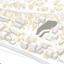
Located between a high street and a highway, the project site currently serves the function of ground floor parking space for a car shop and the ICA supermarket.
This central, industrial area is low in density, low in attraction points, and has low ecological and social quality. Itself serves as a barrier to linking the residential areas on either side.
BRIDGING THE GAP | Urban design proposal
The project treats an industrial site located halfway between Göteborg and Mölndal, next to a giant ICA supermarket.
The proposal for the site involves designing a dense and active neighbourhood, at a crossing point between other residential neighbourhoods and along the central street linking the two cities. It will blend in with the local context, respecting the rules of the urban fabric in terms of height and following the current densification trends of the area. The intention is to create a new attraction point along Mölndalsvägen, which will be a new green and public square, surrounded by urban activities and dense buildings. Diverse activities and building typologies will draw in visitors and new business opportunities will be created, thanks to mixed-use buildings and active ground-floors in a new car-free street structure.
The public square will be a crossing and meeting point and the project proposal will bridge the existing gap in the social and urban form.
0 200 500 m

The main strategy for the creation of new non-motorised streets was the extension of existing urban fabric lines (red arrows).
Two additional diagonal lines were added to break the monotony of those streets and create flow within the two frontal blocks, also providing a direct view highway bridge to the two bridges over the river, facilitating pedestrian and bike orientation.
Existing parking garage New parking garage New non-motorised streets Connections to other streets
BRIDGING THE GAP | Streets and urban fabric
0 200 m


Current - AI 1k

Current - AB 3k Proposal - AI 1k


Proposal - AB 3k Angular integration and angular betweenness analyses of the new nonmotorised street networks support the design intention of creating a central new neighbourhood and public square, with active streets and mixed-use buildings that are fully integrated to the rest of the urban fabric.
The AI 1k analysis suggests a very strong pedestrian use of the site, and the AB 3k analysis suggests strong bike connections through the site.
Angular Integration / Betweenness
Low
High
BRIDGING THE GAP | Urban rules
The project area is completely car-free, as car access to the ICA supermarket and the new parking garage are reoriented to the sides of the project site and pedestrian and bike circulation is encouraged through masterplan strategies.
The new public square was created after analysis of circulation flows towards program activities, with crossable and noncrossable areas.
3 storeys 6 storeys 8 storeys 10 storeys 12 storeys 17 storeys 22 storeys
entrances parking garage entrance pedestrian meandering direct view lines main cycling path bike parking public transport stop
public green, non-crossable public green, crossable common yard club yard terrasses
river crossing sport and playground barbecue, sitting area


0 100 m

BRIDGING THE GAP | Program and plot structure

Ground floor - mixed use

Higher floors, save residential
Parking garage Residential Hotel Offices Retail Café and restaurants Culture
Bike parking Public crossable green Public non-crossable green Terrasses


The complex mixed-use program and attribution of yards to the residents called for a three-dimensional plot structure.
In the two front blocks, the ground floor is divided into two separate plots, with a program consisting of retail, cafés, and restaurants, to allow for a diagonal public passage through them. The upper floors consist of residential apartments surrounding a shared common yard going over the pedestrian street, therefore forming one unique plot.
The parking garage accords a portion of its rooftop to the hotel, to be used as a club yard. The greater portion of the rooftop consists of a shared common yard belonging to the residents of the upper five floors of the adjacent residential building. The first seven floors on the other hand share a common yard with two other blocks.
In terms of program, restaurants and their terrasses are placed along the main streets, the two high rise buildings (offices and hotel) are closest to the cycling route and serve as orientation way points, whereas the cultural building (public library or museum) is located in close relation to the public square.
Legend
Residential surrounding shared yard going over & Residential surrounding shared yard going over &
(Smaller parking garage rooftop) belongs to (Greater parking garage rooftop) belongs to (Large ground floor shared yard) belongs to
BRIDGING THE GAP | Section and scenario
The imagined proposal would be an integral part of the city fabric thanks to mixed-use buildings and activities serving as attraction points, a proximity to public transport and the river, and pedestrian streets of high integration and betweenness.
The high density building typologies are in line with the densification trend of the surrounding site and offer quality housing (with nearly 1500 new dwellings) and business opportunities, including cafes, restaurants, retailing, office space, a hotel, and a cultural building in relation to a green and central public square.


