

SRI POORANI SRINIVASAN
selected works 2021-24
SRI POORANI SRINIVASAN
214 - 517 - 4894
sripoorani7061@gmail.com
EDUCATION
aug ‘23*may ‘25
aug ‘16aug ‘21
HONORS
jan ‘25
may ‘24
feb ‘24
jan ‘24
Master of Science in Urban Design
University of Texas at Austin, TX
Bachelor of Architecture
Anna University, Chennai
jun ‘21
jun ‘20
sep ‘19
Independent Research Travel Scholarship - UTSOA
study on flood resilience and nature-based solutions | Singapore
UTSOA Design Excellence 2023 - 2024
nominees | The water paradox | team of 2
ULI Hines Competition | UT Austin Awards
winner | The Circuit | team of 5
AIANY Design Awards
Citation for Intention to Resolve an Urban Problem
NY Waste Yards | Grain Collective, architectureRED
UGREEN Certification
sustainability workshop certification
The Little Book that Cares
illustration for a COVID fund-raising book publication
Haste out of Waste | MEASI intercollege culturals
winner | team of 2
ACADEMIC AND VOLUNTARY EXPERIENCE
jan ‘25present
aug ‘24 -
dec ‘24
jan ‘24may ‘24
aug ‘21 -
apr ‘22
sep ‘11 -
apr ‘13
Graduate Research Assistant | UT SOA
Community Acupuncture in Dakar | Prof. Dean Almy
Teaching Assistant | UT SOA
Urban Design History, Theory, Criticism | Prof. Dean Almy
Teaching Assistant | UT SOA
Architecture and Society | Prof. Larry Speck
Teaching Volunteer | U&I
English Language
Student Volunteer | Chinmaya Mission
Social service (Seva Sangam)
modelling mapping graphics rendering
AutoCAD | Sketchup | Rhino
ArcGIS Pro | Google Earth Engine
Illustrator | Photoshop | InDesign
Lumion | Enscape | V-Ray
WORK EXPERIENCE
jun ‘24 -
aug ‘24
aug ‘21jun ‘23
Community Planning Intern | Grain Collective, New York
Prepared materials for tabling events, community workshops, and surveys. Interacted with communities about composting, housing requirements, and the organics project.
Worked on research and concept for the landscape project.
NYCHA
Organics Engagement
(DSNY Smart Bins Outreach at NYCHA)
Nostrand Houses Community Priority Survey
NYCHA Riis houses play space development
Architect & Urban Designer | architectureRED, Chennai
Project lead for a 300-unit housing project. Produced GFCs and sales plans, made site inspections, and coordinated with clients and other consultants. Designed podium spaces.
Worked on multiple urban design projects. Responsibilities included team coordination, site visits and documentation, and design exploration of waste yards, streets, and railway platforms and interfaces. Prepared illustrations, drawings, renders, and detailed reports and presentations for client meetings.
Conducted in-depth research on ancient water management systems of Tamil Nadu and ecological concepts like the Miyawaki forests for a master plan project.
Helped in producing tender drawings for institutional projects.
Assetz Sun & Sanctum (housing project-300 units)
New York Waste yards (revitalizing waste yards)
Taluk Office Road (mega streets project)
Southern Railways Redevelopment
MEASI Institute of Management (adaptive re-use)
Vandalur Master Plan (research)
dec ‘20 -
mar ‘21
may ‘19 -
oct ‘20
Architecture Intern | Taliesyn Design, Bangalore
Involved in architecture, interior and furniture design, rendering, drawings, physical modeling, and vendor coordination for an office project.
Office 123 (adaptive re-use)
Architecture Intern | Taliesyn Design, Bangalore
Produced illustrations for presentations. Worked on detailing, drawings, 3d iterations, and physical models.
Assetz 38&Banyan (housing)
Assetz Earth & Essence (housing)
Hindustan Law Institute
combatting flood and drought through ecological urbanism
a waste
NYCHA waste yard redevelopment project
community outreach
summer internship community engagement at NYCHA
middle grounds
mixed income mixed typology urban district
southern railways
railway station and precinct development
nautical narratives
resilience for fishing communities through nature-based solutions
the water paradox combatting flood and drought through ecological urbanism
Type : Academic (MSUD)
Dates : Jan - May ‘24
Location : Austin
Instructor : Prof. Dean Almy
Team : Drishti Gandhi
Role : Mapping, framework concept, 3d modelling and illustrations
Honors : UTSOA
Design Excellence
2024 nominees
The project was a part of the Austin eastern archipelago studio where teams worked on different sites along the I-35 highway to accommodate future densities.
The Water Paradox identifies the flooding and drought extremities of the region because of soil tendencies and proposes water discharge, retention, detention and harvesting strategies as part of an ecological framework for controlled development.
It explores the various intersections of hydrology, soil percolation, transit and green corridors and presents them as opportunities for resilience and livelihood. The focus is on using the terrain to disperse and store water while determining development on areas of percolation and above all, connecting isolated neighborhoods through transit and landscape corridors. The site, sandwiched between important networks and natural sites stitches together commerce, ecology and community.


flood and drought paradox


connecting the urban and the rural
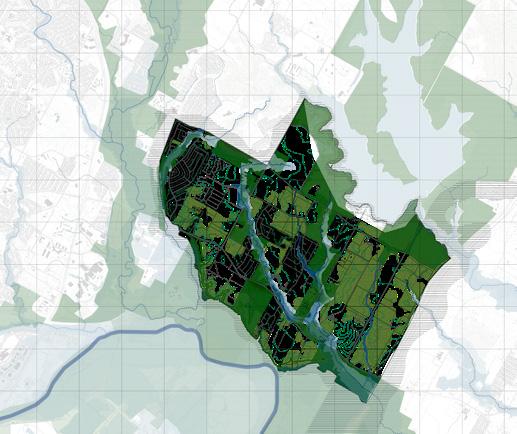
strengthening the riparian edge

density along transit and landscape


ANCHORS
Hindu temple
Austin Rodeo
Kipp School and Ancillary Programs
THE GREEN CONNECTOR
Natural Dams
Integrated Reservoirs
Camp Ground
Walk on Board
Camp fire
Cabins
Flower Viewing
Viewing Area
Fish Related Diving Area
Duck Viewing
Maps and Information
Exercise and Fitness
Playground Hiking
Archery Boating
Wood Gathering
COMMUNITY \ DENSITIES
Snack Bar
Restaurants
Grocery Store
Food Storage
Library
Lodging
Community Gardens
Bookstore / Souvenir Store
MOBILITY
Bike Rack
Proposed Bus Stops
Shuttle Service
Electric Charging Stations
Enriching the riparian corridor by integrating public spaces, landscape, storm water treatment park, bike and pedestrian trails and retail at intersections of transit nodes and water bodies.

Rejuvenating lake wetlands that increase from the Hornsby the lakefront and activities

Transforming road bunds in the floodplains into elevated systems that allow for natural drain-off into retention ponds. Insertion of commercial units that enable a community space.


lake ecosystem by introducing floating increase biodiversity and attract birds Hornsby Bend observatory. Activating and introducing kayaking and fishing activities to boost tourism economy.


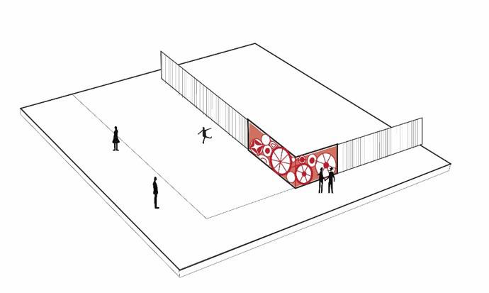
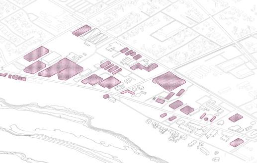
what a waste
NYCHA waste yard redevelopment project
Type : Professional (architectureRED + Grain Collective)
Dates : Sep - Dec ‘22
Location : New York Supervisors : Biju Kuriakose, Kavya Suresh
Role : design concept, drawings, 3d modeling and illustrations
Honors : AIANY Design Awards 2024
Why can’t waste be attractive?
New York City waste yards, while providing a space for waste collection, segregation and disposal in neighborhoods, are also inactive, passive spaces that take up considerable areas of the city’s public realm, especially along the main streets. As these are a series of recurring spaces throughout the developments, there is potential to create a strong image and identity for them. The challenge is to transform these pockets into socially active and responsive spaces that contribute to the city, beyond the
function of waste management with innovative solutions that enable the elements of the waste yard as place making components.
The fence becomes an important element of the waste yard design due to its relationship to the surrounding context. It is re-imagined as an active space that is programmed with functions, information, art and landscape, as appropriate to the specific context, in order to define an identity and to make it a vibrant part of the community.


existing waste yards

activation of the fence

development scale intervention
Development scale - larger waste collection and distribution strategy.
Waste yard scale - the Internal layout and access points to the waste yard.
Spatial / human scale - spatial elements as an extension of the internal pedestrian paths, activated with play spaces.

visual focus of the ground

wasteyard scale intervention

human scale intervention
NYCHA waste yard sites


wayfinding

The waste yard site is at a crossway between the playgrounds and the housing. The design cohesively ties the pathways and acts as a congregational space at the intersection. The play elements like the trampoline, seaters, boards, wall games are playfully arranged as markers of the place.
cooper park statement sign and vehicular entry

20 ft trash containers
notice wall / graphic board pedestrian entry
x/o game wall play bars
trampoline
community outreach summer internship
community engagement
Type : Professional (Grain Collective)
Dates : Jun - Aug ‘24
Location : New York
Supervisor : Sapna Advani, Ali Estefam
Role : community outreach; planning, graphics and preparation for tabling events, community workshops
The Organics project was a time-based community outreach program along with NYCHA and Compost Power to inform the communities about the DSNY Smart Bins and composting ideas. We held tabling events, compost workshops, and community gardening at 13 NYCHA developments and giveaways on Family Days.
The Nostrand Community Priority Survey was a part of the development
shift where the residents were surveyed on what they’re willing to change about their development. I was involved in creating graphics, surveying, preparing for and attending community meetings to inform volunteers about the resident survey process.
The summer internship at Grain Collective exposed me to the groundwork process of urban planning and design.


tabling event at Lehman Village, NYCHA
tabling event at Bronx River, NYCHA
composting workshop at Ravenswood, NYCHA
community meeting at Nostrand Houses, NYCHA


middle grounds
mixed income mixed typology urban district
Type : Academic (MSUD sem 1)
Dates : Aug - Dec ‘23
Location : Austin
Instructor : Prof. Liang Wang
Team : Tess Matzakos
Role : mapping, design framework, concept diagrams and visualization
Middle Grounds is a project that addresses the disparity in economic opportunities on either side of I-35 because of the historical redlining of East Austin. It also addresses the ‘missing middle’ typologies of 2-20 units in Austin, which is predominated by single family houses and highrise apartments, creating an uneven distribution of densities. The rising boom of tech industry and the need for open public recreational spaces plays an
important role in the development of this post-industrial site, which is situated near the East-side Bus Plaza, and edged by the Colorado River, with the East Chavez road cutting through.
Middle Grounds is a mixed-use neighborhood that enables the coexistence of tech companies and a mixed-income neighborhood through a well connected system of public nodes that reflect the cultural values of the neighborhood.

NETWORKS
Activity corridor
Highway
HOUSING
Predominantly Black / Hispanic
Predominantly White
Moderate proportion of missing middle
High proportion of missing middle
PLANNING - Imagine Austin
Neighborhood center
Job center
Industry
Tech
Regional center


mixed densities retaining cultural structures integrating cultural spine

vertical stacking of program


The larger courtyard typology in the main district is more public and faces the cultural spine. It has retail on 2nd floor that is connected from the other side of the road through the pedestrian bridge.


The mat typology creates a middle density that is on a smaller scale and inclusive of nature as it faces the river trails and is interwoven with mini-gardens.

The community market acts as an inviting entry space for the active pedestrian spine of the development. It encourages selfemployment and interacting opportunities for the different housing economies present.
community garden and market


The artist plaza is surrounded by warehouse structures that are creatively reused as gallery spaces and mural canvases. It provides a hangout space for the artist and other community that exists in the site. The site is characterized by these canopies on important cultural and social locations that indicate a significant social pause.


southern railways
mixed income mixed typology urban district
Type : Professional
Dates : Feb - Jun ‘21
Location : Chennai Supervisor :: Kavya Suresh, Visuwa, Biju Kuriakose
Role : Site survey and client discussions, site report, platform design and detail drawings.
Historically, railway stations were the social and economic urban centers in a city - iconic buildings surrounded by an active and vibrant pedestrian realm. With the high pedestrian traffic that stations experience, they have the potential to transform into active and vibrant public spaces, with a distinct identity within the city. This Central Government project re-imagines the station as an integral and natural extension of the city fabric. A place in the city that is more than just a point of required transition - a place with a strong identity, attached memories,
a place of pause, congregation and activities. Shown here, is one of the four sites that I worked on, where we presented our design proposal to the Southern Railways Zonal General Manager and worked with the authorities to understand the footfalls, platform timings and mapped the platform facilities to have a better understanding of the existing conditions. We then designed a station that had an identity and one that was user-friendly, convenient, and communally spaced.


proposed upliftment of entrances for more visibility, way-finding and identity


section BB’
section AA’

design of fob stairway module as a marker with conversational waiting spaces and celebrating the city’s history by framing the structure to capture the surroundings
nautical narratives ( 1 )
resilience for fishing communities in the Bay of Bengal through nature-based solutions
Type : Academic (MSUD thesis)
Dates : Aug - Dec ‘24
Location : Chennai
Instructor : Prof. Dean Almy, Prof. Hope Hasbrouck
Phase : research
Monsoon is a force that changes the winds, the tides, the temperatures, brings rain, and influences the lives of millions of people living on the coast. It is an inherent part of coastal culture and the Bay of Bengal communities depend on it as much as they are affected by it. This research explores the relationship between the monsoon, nature and coastal communities, specifically the fishermen of the city of Chennai.
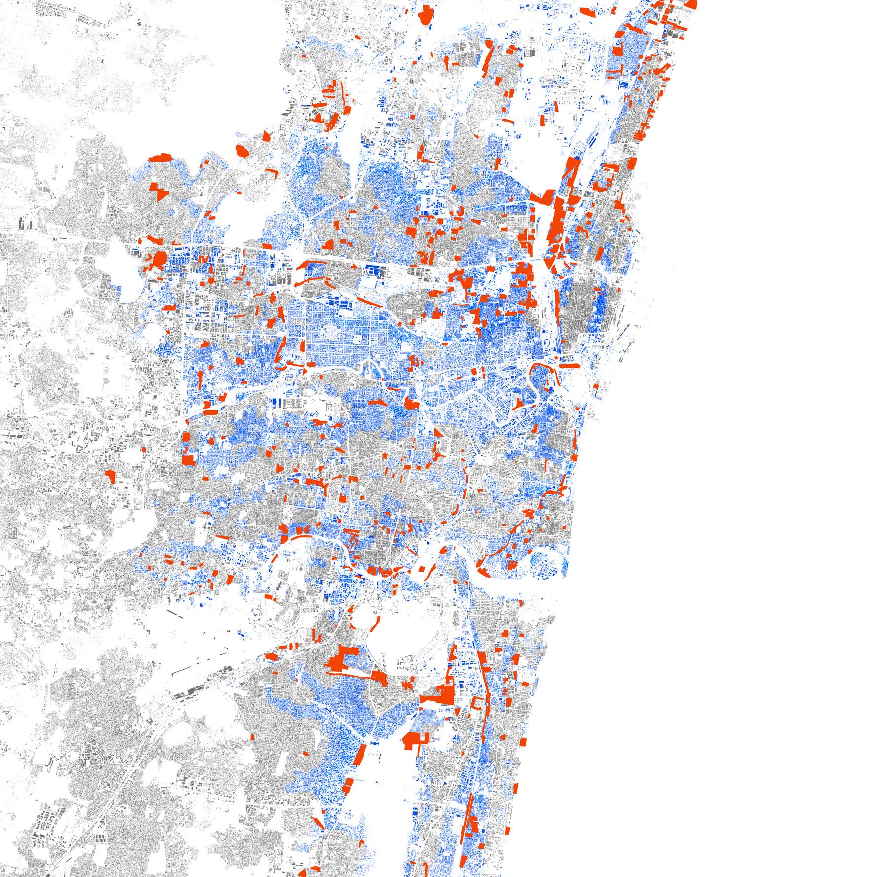
The geography of coastal cities are a composition of different ecosystems exclusive to the coastal areasmangroves, seagrass meadows, estuaries, coral reefs and coastal
wetlands. Mangroves and seagrass beds act as protectors of the coast because of their roots preventing erosion and rough waves. Wetlands act as sponges and so on. It is when these ecosystems are disturbed by unplanned development, that the city suffers. The city of Chennai is one such case.
The work presented in the portfolio is a part of the research phase of my thesis. I am currently working on is the design phase where I aim to study and ideate nature based ecological revival and design strategies for the fisher communities to combat monsoon and climate change.


The Bay of Bengal experience the Indian monsoon which means frequent cyclones in the months of June to December and heavy rainfall. The coast is susceptible to sea level rise and the impacts of a tsunami like that of 2004.
Coastal cities have similarities. The ecosystems - mangroves, seagrass beds, corals, and wetlands provide biodiversity as well as coastal protection from storm surges. Unplanned urbanization threatens this coastal integrity.

urban ecology under threat wetlands, seagrass, coral, and mangroves.
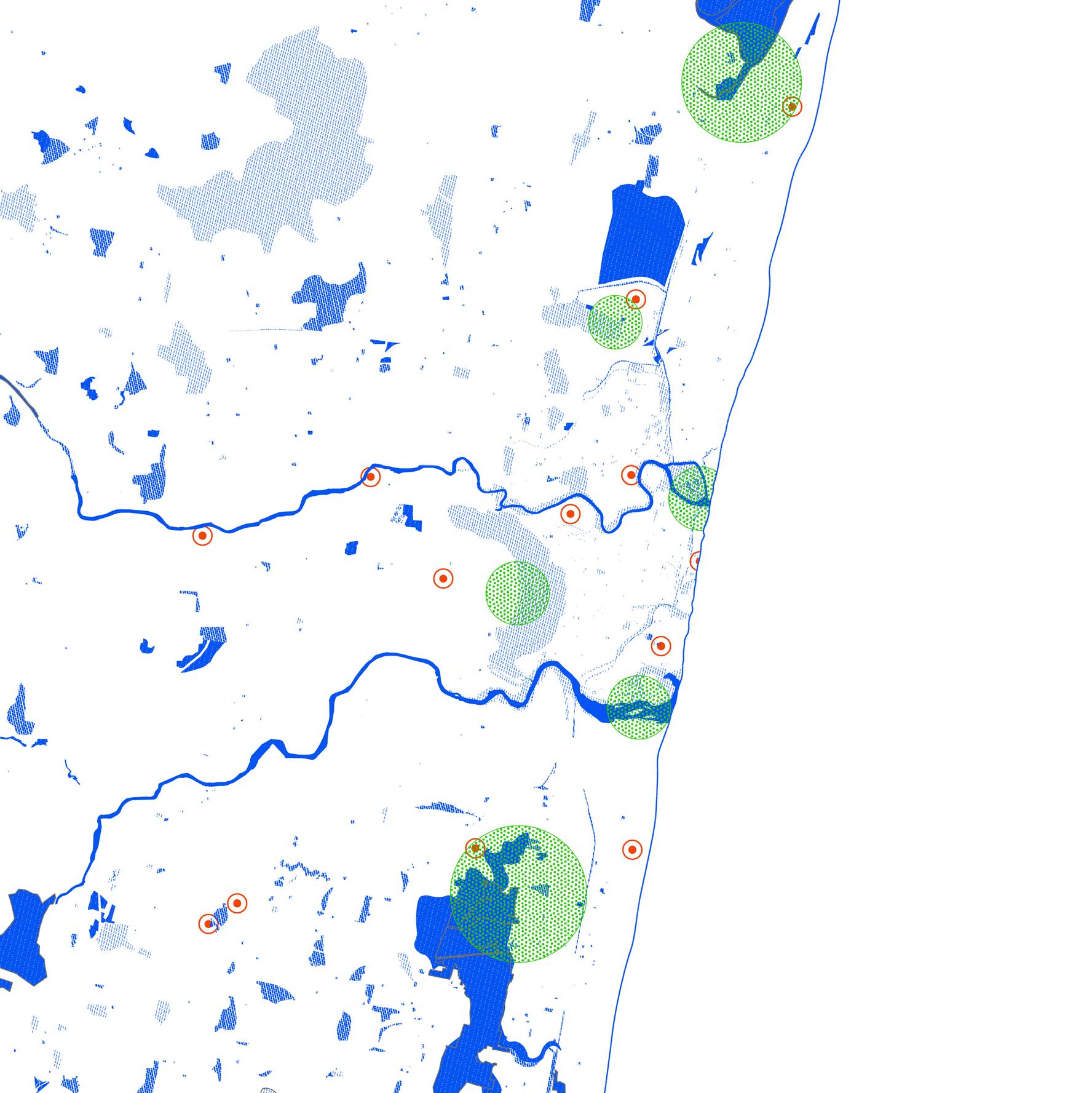
Chennai is a coastal city in the southeastern part of India. It experiences the northeast monsoon from the months of October to December, frequented by heavy rainfall and cyclones. It is a metropolitan city that is also a major port in the Bay of Bengal, home to around 6.6 million people. It also faces the threats of storm surge and sea level rise due to its elevation of 2m to 8m above sea level.
Ennore creek lagoon ecosystem
Vyasarpadi tank
Kodungayur wetlands
Puzhal reservoir
Buckingham canal
Cooum estuary
Adyar estuary
Pallikarnai marsh
Injambakkam sand dunes
Long tank


Representational drawing of the significance of coast to the the fishermen. This is where their livelihood and economy is. Inland displacement as a strategy isn’t an inclusive one. The coast needs to be rethought as a barrier as well as a place of livelihood.