
SRIPOORANI srinivasan selected works - 2016-2024

Master of Science in Urban Design aug ‘23 - present University of Texas at Austin
Bachelor of Architecture aug ‘21
MEASI Academy of Architecture, Anna University, Chennai
Secondary Education (CBSE) may ‘16 Chinmaya Vidyalaya, Chennai
AutoCAD | Sketchup | Rhino
Photoshop | Illustrator | InDesign
Enscape | Lumion | V-Ray
ArcGIS Pro
MS Office
ULI Hines Competition Austin Awards feb ‘24
The Circuit - entry Winner (group of 5)
AIANY Design Awards jan ‘24
Grain collective - architectureRED
New York Waste yards
Citation for Intention to Resolve an Urban Problem Projects Category
Toto Bathroom Competition may ‘20
Taliesyn Design
Top 10 entries (group of 3)
Publications jun ‘20
Article on Biomimetic design - Rethinking the future blog
Illustration - “The Little Book that Cares”
Teaching Assistant jan ‘24 - present Architecture and Society | UTSOA
Teaching volunteer aug ‘21 - apr ‘22
U&I organisation
Artist volunteer jul ‘19
Public wall art | The Hindu
Student volunteer sep ‘11 - apr ‘13
Seva sangam | Chinmaya vidyalaya
(214)-517-4894
sripoorani7061@gmail.com
4305, Duval Street, #121, Austin TX 78751
Architect | architectureRED, CHENNAI aug ‘21 - jun ‘23
Assetz Sun & Sanctum (housing project-300 units)
Project architect | GFC drawings, site co-ordination, client and services co-ordination, design detailing.
New York Waste yards (revitalising waste yards for 16 sites in NYC with Grain Collective, NY)
Project architect | Design strategies, presentations, graphics, team co-ordination.
Taluk office road (mega streets project with The Greater Chennai Corporation)
Team architect | Site visits, drawings, detailed report
Southern Railways Redevelopment (Central govt. scheme)
Team architect | Site surveys, design conceptualisation, technical drawings, client meetings, preparation of report
MEASI Institute of Management (Adaptive re-use)
Team architect | Tender drawings, interior conceptualisation
Consultant | Freelance mar ‘20 - jun ‘20
Thirumazhisai Residence site visit, client meetings, design presentation
Intern | Taliesyn Design, Bangalore dec ‘20 - mar ‘21
Office 123 (office building)
GFC drawings, site co-ordination, client and services co-ordination, design detailing, renders
Kalyan residence (residential) interior design, renderings and drawings
Intern | architectureRED, Chennai may ‘19 - oct ‘20
Assetz 38&Banyan (housing project)
GFC drawings, design detailing
Assetz Earth & Essence (housing project) concept graphics, design
Hindustan Law Insitute (Law institute) concept graphics, presentation, physical modelling
Artech Vytilla (housing project)
Formal exploration, physical model


1. what a waste transforming new york’s waste yards into socially active spaces
2. mega streets streets revitalisation
3. new nostalgia transit-oriented development
4. middle grounds housing and public infrastructure at East Austin
5. chennai beach station redevelopment of railway station precinct
6. the circuit
New York City waste yards, while providing a space for waste collection, segregation and disposal in neighbourhoods, are also inactive, passive spaces that take up considerable areas of the city’s public realm, especially along the main streets. As these are a series of recurring spaces throughout the developments, there is potential to create a strong image and identity for them. The challenge is to transform these pockets into socially active and responsive spaces that contribute to the city, beyond the function of waste managemen with innovative solutions that enable the elements of the waste yard as place making components.


The aim is to transform these wasteyard pockets into socially active and responsive spaces that contribute to the city, beyond the function of waste management by strategically intervening across three scales.
Development scale - larger waste collection and distribution strategy.
Wasteyard scale - the Internal layout and access points to the wasteyard.
Spatial / human scale - spatial elements that have an impact on the human scale and streetscape


The fence becomes an important element of the waste yard design due to its relationship to the surrounding context. It is reimagined as an active space that is programmed with functions, information, art and landscape, as appropriate to the specific context, in order to define an identity and to make it a vibrant part of the community. The ground plane also plays an important role in the sites where many buildings overlook the wasteyards
fence as seating green wall fence as signage fence as play wall fence as seating and mural ground plane articulation use of fence and ground plane in activating the waste yard

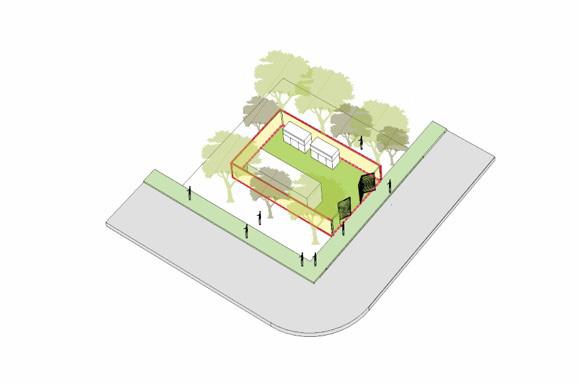
The site sits between two housing blocks, edging the main road on one side and the internal path to blocks on another. A city edge is created, acting as an extension of the sidewalk. The neighborhood edge is defined as an extension of the internal pedestrian paths, activated with play spaces.


The waste yard abuts primary access roads, at the street junction, creating an inactive street corner. The waste yard is tied together with the context, through a visually active ground plane as well. The edge condition of the waste yard is redesigned to make it spatially and visually active. Nodes are defined near existing street corners with related functions and spaces that contribute to the public realm. top view of proposal at monroe wasteyard bottom contextual juxtaposition
“The land that nurtures those who come”, is a very common phrase that describes Chennai, the capital state of Tamil Nadu in south India.The scope of the project, is to do a comprehensive urban study on the region around the central railway station, the gateway to Chennai, with a footfall of around 4 lakh passengers moving in and out of the city, from all over India. The region is famous for its colonial era architecture, the Nehru sports complex, and its trading corridor of leather and timber markets along the Buckingham canal. The project culminates with a proposal of urban strategy that addresses urban issues and potential intervention zones that can socially activate the regions along the transit corridor.


The urban study of the entire periyamet region was structured into 3 zones; zone 1 containing the railway station, hospital and other important public buildings, zone 2 with the nehru sports complex and thriving market and trading population. And zone 3, predominantly residential


The analysis of the entire site resulted in the proposal of interventions at different scales. The ecological corridor of the Buckingham Canal to be revived with recreational activities and other development.A food street would serve the neighborhood and the commuters of the new transit station. The market space would provide for a place for the community and a place for entertainment like the circus and other artist performance.
abandoned salt cotaurs converted to food hub and commercial street catering the 2nd terminal
reinitiating the transit route of the Buckingham canal by providing ferry and kayaking activities recreation zone courts, skating areas to activate
proposed 2nd terminal for southern railways to support overload of services to the chennai central station

rerouting traffic at elephant gate for better traffic management for the new terminal
with badminton rinks and play the canal edge

flea market and open ground amalgamated to a market hub and public plaza
reorganising informal settlements int housing redevelopment for the bamboo weaver community by also providing economic opportunities
elevated cycle track connecting the ecological corridor of Buckingham canal and the Nehru sports complex to provide a healthy and physically active space
permanent shops for merchants

gallery space showcasing the history and heritage of moore market and the traders
After the loss of the Moore market complex to a fire accident near the Suburban Railway Station, the shopkeepers and traders were relocated to a flea market in a nearby zone. As a result of poor infrastructure and congested space, the market failed to claim its glory of the past. The open space acting like a backyard of the market, is often utilised for circus events and political meetings. When not active, the place attracts illegal dumping of waste and uncontrolled parking.
open public plaza used as circus grounds, political meetings. mini stages provided for music performances or casual gathering


Integrating the market building with the open space and creating porosity within the building for open circulation. The complex includes a space for exhibtion of its contextual and people history. The building itself is designed with a street-like market experience for the users.
1.
2. site plan
right - top to bottom
1. permanent shops and market building
2. courtyard space
3. space for temporary vendors
isometric view of moore left - top to bottom exploded isometric view of market complexMiddle Grounds is a project that addresses the disparity in economic opportunities on either side of I-35 because of the historical redlining of East Austin. The rising boom of tech industry and the need for open public recreational spaces plays an important role in the development of this post-industrial site, which is situated near the Eastside Bus Plaza, and edged by the Colorado River, with the East Chavez road cutting through. Middle Grounds is a mixed-use neighborhood that enables the co-existence of tech companies and a mixed-income neighborhood through a well connected system of public nodes that reflect the cultural values of the neighborhood.


City of Austin’s Imagine Austin urban and job centres were studied with respect to density and tech companies. Majority of the urban centres had a high number of tech employees or employers. Along with this, the housing unit density was also mapped to understand the concentration of the ‘missing middle’ density - the density between single family and highrise apartments that is scarce in Austin. left map showing the missing middle density in Austin and the various tech industries situated near Imagine Austin urban centres

Historical policies and infrastructural moves like the I-35 have resulted in the racial segregation and redlining of the black and latino communities located on East of I 35. They’ve been segregated from opportunities in various modes like economy, education, job, etc. And with the increase in home values, East Austin is also vulnerable to gentrification.
right analysis of the economic and opportunity disparity in East and West Austin

The site is predominantly industrial, considering the proximity to the highway that leads to the airport. It is also interesting that there are inserts of among the site, with some of the programs situated in old industrial warehouses that are repurposed to fit in with the trend.
retaining socially relevant programs and structures

buildng density as programmatic clusters


improving pedestrian and vehicular circulation

pedestrian spine

programmatic clusters
Middle Grounds is a neighborhood of mixed economies and cultures anchored by public spaces that respond to the existing social uses. The hybridity and vertical stacking of programs within each block allows for cross-disciplinary interaction enabling the neighborhood to socially thrive
nodes in each block

The project aims at making the waterfront more accessible to the public by linking the north of East Chavez Road at key moments like the bus plaza, where there is a bridge that connects the plaza to the urban trails near the waterfront.


The artist plaza surrounded by warehouse structures that are creatively reused as gallery spaces and mural canvases, provides a hangout space for the artist and other community that exists in the site. The site is characterised by these canopies that indicate a significant social pause in the neighbrhood.
top axonometric view of artist gallery bottom view of artist plaza from a housing terraceThe Chennai Megastreets Project is a project undertaken by Greater Chennai Corporation (GCC) to redesign and develop streets in Chennai to be future-ready and prioritised for nonmotorised transport. The designs will incorporate various aspects of mobility, utility and livability. The vision for this project therefore draws on this notion of Adyar being both a place as well as a portal and seeks to strengthen these identities as manifested in its street network through the power of placemaking.


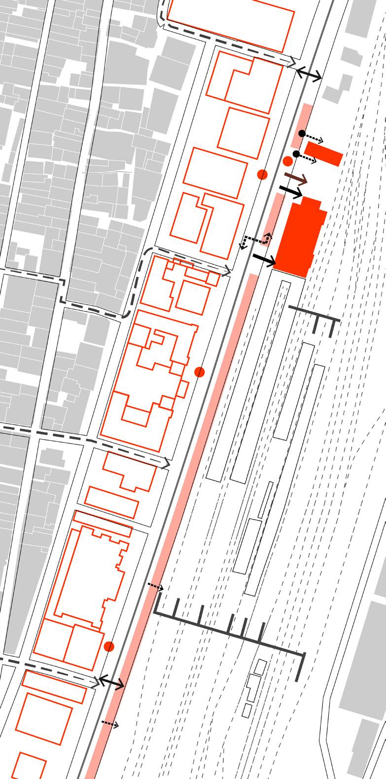
The Taluk Office Road was analysed in various aspects. In terms of building use, building heights sectional relation, traffic count, vendor spaces, activities, etc. It was concluded the street had a dual nature on either side of its centre. The southern side is more quiet and less active because of the decrease in public program and increase in vegetation. This trend is seen in most cases of the analysis
left building height and use analysis right social activity, vending and parking analysis


Taluk office road has a very public pedestrianised edge towards Metro plaza. The active edge with commercial as well as public amenities makes it a very active zone.
Taluk office road has a very green edge towards Raj Bhavan junction . The built area is less compared to the metro plaza edge. The canopy has the potential to provide a nice shaded walkway for the pedestrians as well as cyclistis.
bioswales and increased landscape buffer at junction
courthouse security kiosk and seating along the fence
kiosks for street vending
wider pedestrian path for the bus commuter traffic. bus shelter with landscaping as relief from the heat


linear park that acts as both a recreational space and a natural sponge with systems of bioswales and rain gardens, capturing stormwater. dedicated cycle track
outdoor gym / play area for kids of the neighborhood
compound wall with in-built planters and seating


Historically, railway stations were the social and economic urban centres in a city - iconic buildings surrounded by an active and vibrant pedestrian realm. With the high pedestrian traffic that stations experience, they have the potential to transform into active and vibrant public spaces, with a distinct identity within the city.Reimagining the station as an integral and natural extention of the city fabric. A place in the city that is more than just a point of required transition - a place with a strong identity, attached memories, a place of pause, congregaton and activities.

Multiple streets open from George town to the beach road. Improved accessibility of the station from the neighbourhood streets for pedestrian safety is vital. Intervention is required to minimise the visual impact of subway and Burma bazaar roof structures and create a holistic design.

subway redesigned to have a smaller footprint, integrate with station design and carry signage
Temporary structure of Burma bazaar kiosks redesigned to bring in strong imageability and integration with station


The station requires upgradation of station building in terms of facade, interior finishes, design of seating and kiosks and better circulation organisation for offices with an integrated approach to signage and wayfinding. A separate set of amenities such as a ticketing counter and toilets near entry E will help segregate traffic and improve user comfort within the station precint.
The Chennai beach station, being a terminal for multiple local and express corridors, has a total of 9 platforms which are accessed from the concourse at the station entry and the foorbridge at the far end. The platforms are typically island-like and are more shaded towards the station building side.


In order to reach the station building from PF. 09, one has to walk in the opposite direction to FOB 02, and get to another platform and reach the station, as FOB 01 does not have access to PF 09. As a result, people use an informal path on the track to access PF 08,09, which is unsafe.
left footbridge section and station- context sections right footbridge and platform conditions
When getting off the trains, there is no signages regarding exits available, amenities, nearby bus stop or metro etc.

The space underneath the footbridge is underutilised or used as storage space that is not maintained properly. The project proposes activating these spaces as places for cafes and seting while also having murals of the city. The perforations of the wall make a good frame of the historic context of the station.


Platform organisation through objects of activitydesign of seating and kiosks and integration of FOB to ensure maximising activity areas for passengers with high level of accessibility.
left 1. footbridge design 2. kiosk and seating 3. unshaded platform right-toptobottom 1. highlighting burma bazaar entrance 2. foot-over bridge design 3. Platform seating and kiosk design platform designBeing at the historical core of Seattle, the Circuit celebrates the diversity of cultures and domains around it. The project creates opportunities for the tech, healthcare, artist and other communities and facilitates an environment where they can afford improved livability. The site is revived through housing for the working sectors and a place for collaborative learning and innovation. The Circuit transforms the region, from a “skid row” that divided the communities, into a crossover that brings people of diverse backgrounds together into a thriving neighborhood.


The housing for employees not only offers a “live near work” but also a “live near leisure” lifestyle. Seattle has long been a birthplace for impactful ideas and successful markets. The innovation hub becomes a lab for cross disciplinary fields to share knowledge and ideate. The home is a place for the homeless population of Seattle, where they get the rehab and training needed, to become healthy and skilled to become self-supported in the society.

increasing mobility

catering to different communities

mixed use programming with focus on institutional
left - top to bottom objectives and programs site plan right concept diagrams


The proposed mix of programs with ground floor activation makes the street lively.Accessible public spaces and pedestrian paths are designed to create a livable and inclusive place. Aligning with Seattle’s zero Carbon goals, the project also incorporates renewable energy sources and green infrastructure to create a resilient neighborhood. New construction is made of timber, reducing the cost of construction while increasing affordability and sustainability.


The first phase will be the King County Correctional Facility building, reuse the existing structure, and to build a tech innovation incubator space with a par tnership between Amazon and the University of Washington. The second phase will develop the community green space to create a more welcoming edge next to the highway, while also promoting leisure. The third phase will develop the exhibition/incubator space that also houses mixedresidential units, and retail.


top to bottom user experience
phasing partnerships


The project aims at celebrating the history of the yesler site and pioneer district, while also encouraging the artist communities and the food culture. Spaces like the food market which are tied to services from the transitional home and wall murals by local artists make the place more communal and economically circular.
Active mobility and retail along the 5th Avenue from the new light rail station entrance Pedestrianized Yesler street and food market supported by the transition home community

The project preserves most of the important historic buildings like the King County Courthouse, the Yesler building, Nipon Kan theatre and the Chinook building which is a LEED certified building. It adaptively reuses the correctional facility structure as a housing component

top adaptive reuse programs bottom sustainable elements

The waste yard sits at the intersection of Mother The location of the site is at the junction of many communities of different races, culture and employment. To acknowledge this fusion, the project provides spaces for expression of their arts and culture. The Food hall acts as a community space that brings together different cuisines and other public spaces offer artists to entertain and educate through arts based learning.