

TO SAVE SCOTCH BONNET ISLAND Rebuilding Healthy Marshes
By Lenore Tedesco of The Wetlands Institute
As spring rolls into the marshes, we are excited to provide an update on the marsh rehabilitation project at Scotch Bonnet Island in the marshes adjacent to The Wetlands Institute. Our goal was to save Scotch Bonnet Island from drowning. All of us at The Wetlands Institute, along with our project partners at the U.S. Army Corps of Engineers (USACE) and the New Jersey Department of Environmental Protection’s Fish & Wildlife division, are pleased to report that the construction phase of the project was successfully completed this past fall. The project is easily seen from Stone Harbor Boulevard and the institute, and I hope you have been following our progress on social media and in the news.
This bene cial-use project used clean sediment dredged from the New Jersey Intracoastal Waterway to increase the elevation of low marsh areas that have fallen below the elevation range for healthy marsh. Marshes are at their healthiest when they are nourished by tidal waters. However, when they are inundated too often and too deeply, they begin to deteriorate and drown. Our research has shown that many marshes in our area are being stressed by rapidly rising seas and are at a tipping point. Since the 1950s, the Scotch Bonnet Island marshes have lost more than 30% of their area to marsh drowning, and formerly lush expanses
of marsh grass are increasingly converting to mud ats and open water.
The goal of the project is to restore lost marsh by reestablishing suitable levels of tidal ooding so that it has the appropriate balance with life-giving tides. Lifting the marsh elevation with dredge material will ensure that the marshes you love to visit and explore – and are the core of our laboratory and classroom – are healthy and vibrant for decades to come.
Work began with navigation channel maintenance using hydraulic cutter-head dredging techniques to clear two areas of critical shoals in the vicinity of Nummy Island. Dredged material was tested and con rmed to be free of contaminants, and provided a sediment mixture of ne sand and mud that creates a favorable substrate for marsh rehabilitation. This dredge material slurry was pumped nearly 2 miles though a oating pipeline and sprayed onto a section of marsh managed by NJDEP as part of the Cape May Coastal Wetlands Wildlife Management Area, just south of Stone Harbor Boulevard at Scotch Bonnet Island.
The construction phase began in early October with eld crews from Barnegat Bay Dredging Co. placing biodegradable coconut ber “logs” on the marsh surface to help settle out the sand and mud and build elevation in the most vulnerable areas of the marsh to maximize the

e ectiveness of the placement. Other teams from the USACE worked for several days to construct barriers in the tidal channel system to slow the ows of pumped dredge waters and sediments to encourage their deposition on the marsh surface. USACE research division scientists and engineers, along with partner scientists, installed monitoring systems and mapped the site to document pre-placement marsh conditions and the placement project as it was being implemented.
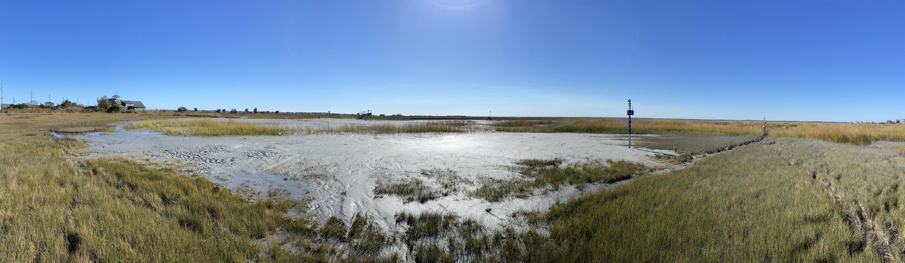
The pumping phase began in mid-October and continued through the first week of December and progressed largely as expected. As sediments were deposited on the marsh, the outfall pipe was moved to direct ows as needed. As material placement was nearing completion, a mini dozer was brought on site to help squeeze water out of the sediments and grade the surface to the target elevations we established. At the completion of the construction, as planned, the elevation is slightly higher than we expect it to be when the site settles out more. The marsh elevation is currently between 4.2 feet NAVD88 (North American Vertical Datum of 1988) and 2 feet NAVD88, and the material is greater than 3 feet thick in many places. In total, 14,000 cubic yards of sand and mud were placed on the marsh, covering an area of 5.5 acres.
The placement smothered the existing marsh grasses, but the new surface was designed and constructed to

Drone image of sediment placement for marsh restoration
Newly placed sediment to rehabilitate the marsh adjacent to The Wetlands Institute
Sand and mud being pumped onto the marsh from dredging operations in the NJ Intracoastal Waterway
continued from page 74


settle to the elevations for new marsh grass colonization after a few months. Our experience on similar projects indicates that the muddy surface takes about one year to stabilize before it starts to recover. New grasses from the natural seedbank typically begin to grow in the second growing season. Planting does not seem to accelerate the recovery time of the placement areas; allowing natural recovery is typically the best approach. Inspection of the new placement surface shows that it already has signi cant coverage of marsh grass seed, which washed in following the placement, hopefully setting the stage for rapid natural marsh grass colonization. While this project is focused on rehabilitating the marsh, we also
kept wildlife in mind. The Scotch Bonnet Island project and others like it are completed at times when wildlife usage of the marsh is much lower, to help minimize short-term impacts while maximizing the long-term bene ts. Our observations while the site was under construction showed wildlife bene ts during the placement. Large numbers of shorebirds and gulls frequented the site looking for tasty morsels that were transported with the dredged sediments. During the construction phase, we had several high-water events, and the birds immediately recognized the value of the higher marsh surface; we saw them in impressive numbers resting and foraging on the sand and mud ats when the rest of the surround-

Sediment placement activities drew shorebirds including dunlin and the rare American golden plover that were feeding on the placement site.
Diagram of marsh conditions. Current marsh flooding where repetitive flooding is too high; drowning marshes.
Graph showing actual original marsh surface (green) and new marsh surface (brown) and sediment thickness of 3 feet.
Elevated marsh surface using dredged sand and mud to raise marsh to ideal tidal flooding levels.


ing marsh was ooded. The project even attracted a rare American golden plover that quickly became the star of the placement, drawing birding enthusiasts from all over the area seeking to catch a glimpse.
For the past several years, a large group of scientists and engineers have been planning and designing this project and working to understand the marsh’s condition and needs. There has been an extraordinary commitment to monitoring and managing the site to ensure the best possible outcomes. This e ort has already provided important opportunities for natural resource managers, local mu-
nicipalities, and state and federal partners to see rsthand how clean dredged materials can be used to rehabilitate drowning marshes. Lessons and know-how from this project are already informing other projects and contributing to scaling-up e orts to help build resilience into our marshes. Numerous partners, in conjunction with the scientists at The Wetlands Institute, will continue monitoring e orts to learn the most we can and continue our work to translate research into action.
For more information, visit wetlandsinstitute.org/scotchbonnet. A timelapse video of the project can be seen at youtu.be/E_MdOmeQFRk.


Mini dozer grading sediment to achieve new marsh elevations
Hydraulic pumping of sand and mud attracted shorebirds