6 minute read
Get Outdoors


NEWHAVEN & PIDDINGHOE WALK
Fancy a walk that combines coastal lookouts and cliffs, an old smugglers haven and a riverside ramble? Then do as Robert Veitch did and head to Newhaven and Piddinghoe for a glorious walk among interesting and varied landscape containing some remarkable views
From West Quay car park head south along the pavement, beside the River Ouse, passing jetties, dolphins and boats along the way, accompanied by a whiff of iodine, seaside and quayside aromas, plus the squawking of gulls. After 500m the path turns sharp right, around the marina to join West Quay. Continue along the pavement to the mini roundabout, before turning left into Fort Road. After 200m turn right by the lamppost adorned with the green ‘Seahaven Coastal Trail’ sign.
The route wends a way up into Castle Hill Nature
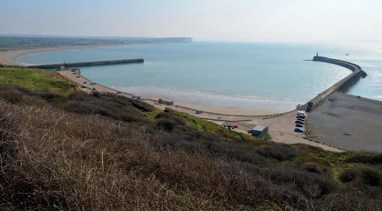
Looking south into Newhaven Marina The Old Coastguard Lookout
Beside the River Ouse
Reserve, getting steeper beyond the 1.8m (5’11”) height limit, before swinging hard left, then bearing right, past the barrier where the drive splits. Keep climbing uphill, easing around to the right as the gradient starts to reduce and the roadway narrows. Turn left at The Old Coastguard Lookout and take the steps to the former gun battery. Under clear skies the view of the east pier and west pier arms, plus the coastline towards Seaford and Seaford Head will make the ascent worthwhile.
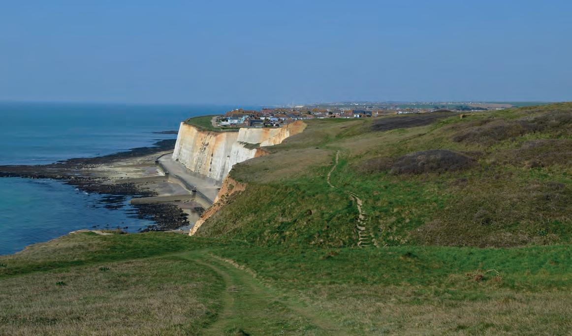
Once the appetite for scenery is satiated, head west and follow the grassy path down steps through the flowering gorse and then along the cliff top. The path hugs the cliff edge, so take extreme care because there is no fence. Note the wild geraniums near Old Nore Point, clinging to the very edge of existence. At the brow, turn and view the ground already covered, then continue west towards Peacehaven and Brighton, both easily visible ahead. At Cheyne Gap, the path sneaks inland to cross the day’s solitary footbridge, then it’s over a small brow and downhill. About 50m before the eastern periphery of Peacehaven, turn right at the fingerpost.
A whiff of iodine and the squawking of gulls
Aim uphill, following the concrete drive to the yellow barrier and the sound of traffic. After the natural sounds of the coastline, the sound of modernity overwhelms the ears. Cross the A259 at the traffic island, then turn right and follow the pavement uphill, turning left 150m past the caravan park, into Maple Road.

Dipping down into Cheyne Gap with Peacehaven beyond

Veer left after 60m, across the grass towards Abbey Avenue and the caravan park, then swing right at the fingerpost and continue past the three small conifers, easing downhill between the fence and the scrub.
Keep right in the crop field, along the boundary and over the brow, where distant views of Mount Caburn and the aerials atop Beddingham Hill are glorious on a clear day. At the far end of the field, turn right into the scrub of Bollen’s Bush then after 50m turn left and walk 300m to the stile.
Once over the stile, keep to the right in the field and ignore the stile on the right. Distant views of Mount Caburn and the aerials atop Beddingham Hill are glorious on a clear day

Where the fence turns right, strike out across the field to the domed 61m (200 feet) summit of Nore Down 150m ahead, then aim for the stile on the other side of the field. Amble across the adjacent pasture in the same general direction to the next stile, then across the following field towards the church steeple.
Keep to the left of the farm buildings, passing the storage containers and then the metal 7-bar gate.

Looking across the River Ouse to Beddingham Hill
Another metal gate with a side gate precedes the junction with the road, which should be crossed with care, as the traffic whizzes by.
Wander past the bollards, then though the green picket gate to the next road and into the centre of the former smuggling haven of Piddinghoe. The path opposite mounts the bank and leads around the right, towards the Parish Church of St John, Piddinghoe, and its rare round Norman tower, which is worth pausing for. Two small treestump bollards precede the drop down the slope to the River Ouse.
At the river, turn right and walk atop the levee, through two gates set a short distance apart. The path runs between the river and Piddinghoe Pond, which was a 19th century quarry, but has been used for sailing and angling since the 1950s.
Beyond the pond, the Energy Recovery Facility dominates the vista across the river. To the right is Riverside Country Park, which for many years was a refuse tip. Continue along the levee path as it bears right into the backwaters of Denton Island and past a plethora of moored boats in various sizes, styles and colours.
At the end of the path turn left, passing between the wooden bollards into Robinson Road, then after 50m turn left into Elphick Road. At the far end, drop down the steps and turn left. Take the colourful underpass on the right, then turn left and follow the pavement into North Lane, towards the traffic island. Cross over and pass the bollards between the buildings into the High Street, before turning left, then after 50m turn right into Bridge Street.
At the far end by the blue and white boat, cross the
The Parish Church of St John, Piddinghoe

Cormorant statue beside the River Ouse

ring road at the traffic lights. Turn into Riverside North and from here its 200m alongside the river, back to the car park.
After that, the rest of the day is yours to enjoy, and after a good walk, well done, a little leisure and pleasure is well deserved. l
Robert has tested the route personally, making sure it is suitable for walking. However, even he cannot guarantee the effects of the weather, or roadworks, or any other factors outside of his control. If you would like to send your feedback about a local walk, please email editorial@sussexliving.com
Distance: 6.75 miles Walk Time: 2¾ - 3 hours Stiles: 3 Gates: 5 Footbridges: 1 Footwear: Summer is coming, so if it’s been dry then trainers should be fine Elevation Gain: 135m (443 feet) Calorie Burn: Approximately 650kcal Map: OS Explorer OL11 Parking: Pay parking is available at West Quay car park, Riverside North BN9 9BP No charge on Sundays
YOUR PEST, OUR PROBLEM.

FIRST-CLASS SERVICE | VALUE FOR MONEY | TRANSPARENT PRICING | AWARD WINNING | EXPERT ADVICE FREE SURVEY & COST COMPARISON