2 minute read
History-YaptonVillage Pound&Green


Yapton Village Pound & Green
By Allen Misselbrook, Yapton & Ford local history
Advertisement
Village Green and Pound
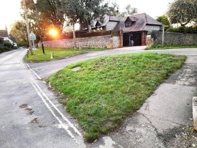
Most villages in England by the end of the Medieval period (13th to 15th c.) had a ‘Village Pound’. The word ‘pound’ being of Saxon origin and meaning an enclosure. Its main use was to hold stray farm animals such as cattle, goats, pigs and sheep for up to three weeks or until the owners claimed them. Yapton was no exception. According to the Victoria County History, a Pound was constructed in Yapton c.1842 but was moved to a new site 10 years later. The Ordinance Survey map of 1897 indicates a half-acre plot of land called the Pound which was situated in the corner of Berrea Court estate, on Church Road next to the entrance of the Twitten, a walled footpath connecting Church Road to North End Road. There was normally a fee to pay by the owner of the strays to the landowner on whose property they were found to cover any damaged caused, also to the ‘pound-keeper’ for feeding and watering the animals while impounded. The usual practice for payment was for the landowner to take a stick or piece of wood and notch it a number of times equivalent to the number of animals in question. He would then split the stick down the middle, keeping one half and giving the other half to the pound-keeper. The owner of the animals would pay the landowner his dues and receive in return the half stick which he would take to the pound-keeper. If the half sticks matched, the keeper would release the animals after receiving the cost of their keep. The general rule was that if the animals were not claimed after three weeks they were taken to market and sold. The proceeds being used to settle the fees. To date research has not revealed when the Pound ceased to be used for its original purpose. What is known is that the half-acre piece of land in question was being offered for sale at the Norfolk Arms, Arundel in 1867. The Ordi- Village Pound and Green nance Survey map of 1897 OS Map 1876 shows two houses having been built on the site. Today they are called East and West Pound Cottages. During a conversation with Jim Diggance shortly before he passed away in 1994, the subject of the Pound and the area of grass between it and Church Road cropped up. Being a member of the Diggance family, well known in the village as the Postmasters, he was passionately interested in the history of the village. He informed me that the area of grass was all that remained of the old village green, a fact that I have not been able to confirm. This area is highlighted on the 1876 O.S. map and remnants of it can still be seen albeit greatly reduced in size.
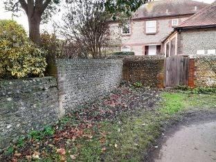
Part of Pound Wall with Rumford in the background
In recent years the house named ‘Rumford’, was built in the corner of Berrea Court, the drive of which cut through the green and the site of the Pound. Part of the wall still exists and can be seen from the Twitten opposite to West Pound Cottage. If any reader can add to my knowledge regarding this area, I would be very interested to hear from you. To contact Allen Misselbrook on a local history matter please email: allen@yaptonhistory.org.uk


