ACKNOWLEDGEMENT ...


Iexpressmysincerethankstomybelovedwifeforyourconstanthelp,supportand encouragementwhilecompilingthisbookaftercompletionofSet1.Itwouldhavebeenimpossibletocomplete thisbookwithoutyourcontinuouscheer-upandguidancerightfromthebeginningtilltheend.Yoursuggestions forshortlistingtheinformationrelatedtotopicsofyourinterestincludingRemoteSensing&GIS,Urban Governance/Geography/Economicswasagreathelp.Iamdedicatingthisbooktoyou&ourbeloved foryourencouragementandlove.Iwouldalsoliketothankyoufortakingalltheeffortsinprocessof publishingthebook.Thankyousomuch.
 -Ar.SwapnilVidhate


PartACommon PageNo. Section1Architecture,PlanningandDesign 1-56 1.1ArchitecturalGraphics 3 1.2VisualCompositionin2Dand3D 6 1.3ComputerapplicationinArchitectureandPlanning 13 1.4Anthropometrics 19 1.5OrganizationofSpace 20 1.6Circulation-HorizontalandVertical 22 1.7SpaceStandards 27 1.8UniversalDesign 28 1.9Buildingbyelaws 29 1.10BuildingCodesandStandards 34 Section2ConstructionandManagement 57-98 2.1ProjectManagementtechniques(CPM,PERT) 59 2.2EstimationandSpecification 64 2.3ProfessionalPracticeandEthics 67 2.4FormandStructure 89 2.5PrinciplesandDesignofDisasterResistantStructures 91 2.6TemporarystructuresforRehabilitation 97 Section3EnvironmentalPlanningandDesign 99-130 3.1NaturalandMan-madeEcosystem 101 3.2EcologicalPrinciples 104 3.3EnvironmentalconsiderationsinPlanningandDesign 106 3.4Environmentalpollution-types,causes,controlsandabatementstrategies114 3.5SustainableDevelopment,goalsandstrategies 117 3.6ClimateChangeandBuiltEnvironment;Climateresponsivedesign 119 Section4UrbanDesign,LandscapeandConservation 131-172 4.1Historicalandmodernexamplesofurbandesign 133 4.2Elementsofurbanbuiltenvironmenturbanform,spaces,structure, pattern,fabric,texture,grainetc. 148 4.3Conceptsandtheoriesofurbandesign 150 4.4Principles,toolsandtechniquesofurbandesign 152 4.5Publicspaces,character,spatialqualitiesandSenseofPlace 154 4.6Urbandesigninterventionsforsustainabledevelopmentandtransportation157 4.7DevelopmentcontrolsFAR,densitiesandbuildingbyelaws 158 4.8UrbanRenewalandConservation,HeritageConservation 158 4.9Historicalpublicspacesandgardens 162 4.10LandscapeDesign,SitePlanning 163
Index
Section5PlanningProcess 173-196 5.1Salientconcepts,theoriesandprinciplesofurbanplanning 175 5.2Conceptsofcities 188 5.3Conceptsandtheoriesbytrendsettingplannersanddesigners 189 5.4Ekistics,UrbanSociology 189 5.5Social,Economicandenvironmentalcostbenefitanalysis 189 5.6Methodsofnon-spatialandspatialdataanalysis 193 5.7DevelopmentGuidelines-URDPFI 196 Section6Housing 197-214 6.1HousingTypologies,Concepts,PrinciplesandexamplesofNeighborhood, AffordableHousing 199 6.2Residentialdensities 204 6.3RealEstateValuation 205 Section7ServicesandInfrastructure 215-258 7.1FirefightingSystems 217 7.2BuildingSafetyandSecuritySystems 222 7.3BuildingManagementSystems 224 7.4WaterTreatment,WaterSupplyanddistributionsystem 225 7.5WasterHarvestingSystems,Principles,PlanningandDesignofStormwater drainagesystem 229 7.6SewerageandSewagedisposalmethods 232 7.7MethodsofSolidWasteManagement-Collection,Transportationand Disposal,RecyclingandReuseofSolidWaste 238 7.8Landuse-transportation-Urbanforminterrelationships 243 7.9DesignofRoads,Intersections,GradeSeparatorsandParkingAreas 244 7.10HierarchyofRoadsandLevelofService 253 7.11Para-transitsandothermodesoftransportation,Pedestrianandslowmovingtrafficplanning 256 PartB1Architecture SectionB1.1HistoryandContemporaryArchitecture 259-314 1.1.1PrinciplesofArtandArchitecture 261 1.1.2WorldHistoryofArchitecture:Egyptian,Greco-Romanclassicalperiod, Byzantine,Gothic,Renaissance,Baroque-Rococo. 261 1.1.3ArchitecturaldevelopmentsinceIndustrialrevolution 270 1.1.4 RecenttrendsinContemporaryArchitecture:Artnouveau,ArtDeco, Eclecticism,Internationalstyles,PostModernism,Deconstructionin architecture,etc. 274 1.1.5InfluenceofModernartandDesigninArchitecture 289 1.1.6IndianVernacularandTraditionalArchitecture,OrientalArchitecture 292 1.1.7Worksofrenownednationalandinternationalarchitects 306
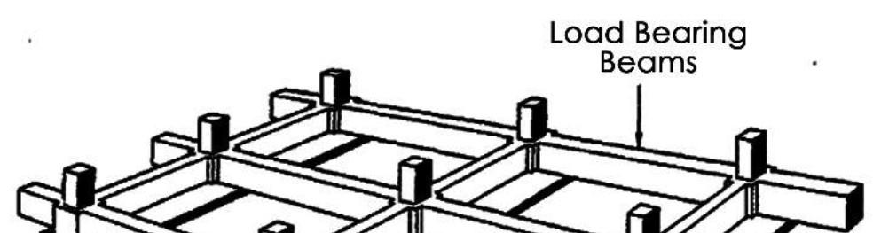
SectionB1.2BuildingConstructionandStructuralSystems 315-444 1.2.1Buildingconstructiontechniques,methodsanddetails 317 1.2.2Buildingsystemsandprefabricationofbuildingelements 353 1.2.3PrinciplesofModularCoordination 357 1.2.4Constructionplanningandequipment 360 1.2.5Buildingmaterialcharacteristicsandapplications,alternativebuilding materials 362 1.2.6Principlesofstrengthofmaterials 385 1.2.7Designofstructuralsystemandelementsinwood 400 1.2.8Designofstructuralsystemandelementsinsteel 415 1.2.9DesignofstructuralsystemandelementsinRCC 422 1.2.10ElasticandLimitStatedesign 433 1.2.11PrinciplesofPre-stressing 436 1.2.12HighRiseandLongSpanstructures,gravityandlateralloadresisting systems 439 SectionB1.3BuildingServicesandSustainability 445-508 1.3.1SolarArchitecture 447 1.3.2Thermal,VisualandAcousticcomfortinbuiltenvironment 451 1.3.3NaturalandMechanicalVentilationinBuildings 465 1.3.4Air-conditioningsystems 467 1.3.5SustainableBuildingStrategies 472 1.3.6BuildingPerformanceSimulationandEvaluation 476 1.3.7IntelligentBuildings 478 1.3.8Watersupply,Sewerageanddrainagesystems,PrinciplesofInternaland Externaldrainagesystem,Sanitaryfittingsandfixtures,Plumbingsystems.480 1.3.9PrinciplesofElectrificationofBuildings 493 1.3.10ElevatorsandEscalators-StandardsandUses 501 PartB2Planning SectionB2.1RegionalandSettlementPlanning 509-522 2.1.1Regionaldelineation,SettlementHierarchy,Types&HierarchyofPlans 511 2.1.2VariousSchemesandProgramsofCentralGovernment 513 2.1.3TransitOrientedDevelopment(TOD),SEZ,SRZ,etc. 513 2.1.4PublicPerceptionandUserbehavior 514 2.1.5NationalHousingPolicies,ProgramsandSchemes 514 2.1.6Slums,SquattersandInformalhousing 519 2.1.7Standardsforhousingandcommunityfacilities 520 2.1.8HousingforSpecialareasandneeds 521
SectionB2.2PlanningTechniquesandManagement 523-552 2.2.1ApplicationofGISandRemoteSensingtechniquesinUrbanandRegional Planning 525 2.2.2ToolsandTechniquesofSurveys-Physical,Topographical,Landuseand Socio-economicSurveys 531 2.2.3UrbanEconomics,Lawofdemandandsupplyoflandanditsusein planning 536 2.2.4GraphicpresentationofSpatialdata 538 2.2.5LocalSelfGovernance,PanchayatRajInstitutions 540 2.2.6PlanningLegislationandimplementationLandAcquisitionAct,PPPetc.541 2.2.7DecisionSupportSystemandLandInformationSystem 545 2.2.8UrbanGeographyandEconometrics 547 2.2.9ManagementofInfrastructureProjects 547 2.2.10Demographyandequityinplanning 550 SectionB2.3InfrastructurePlanning 553-568 2.3.1ProcessandprinciplesofTransportationPlanningandTrafficEngineering555 2.3.2RoadCapacityandTravelDemandForecasting 555 2.3.3Trafficsurveymethods 557 2.3.4Trafficflowanalysis 558 2.3.5Trafficanalysisanddesignconsiderations 561 2.3.6TrafficandTransportmanagementandcontrolinurbanareas 564 2.3.7Masstransportationplanning 566 2.3.8IntelligentTransportationSystems 567 2.3.9UrbanandRuralInfrastructureSystemNetwork 568 Bibliography 569-571
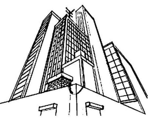
1.1ArchitecturalGraphics


Thearchitecturaldrawingneedstorepresentthree-dimensionalforms,constructions,andspatialenvironmentson atwo-dimensionalsurface.Threedistincttypesofdrawingsystemshaveevolvedovertimetorepresentit,which are-Multiview,Paraline,andPerspectiveDrawings explainedbelow.
Term Description Projection Drawing
PicturePlane
Sightlines
HorizonLine
Centerof Vision
Theground plane(GP)
Theground line(GL)
Coneof Vision
Convergence
Allthreemajordrawingsystemsresultfromathree-dimensionalsubjectwhichisprojectedonto atwo-dimensionalplaneofprojection,ormoresimply,ontothepictureplane.
Allthreemajordrawingsystemsresultfromthewayathree-dimensionalsubjectisprojected ontoatwo-dimensionalplaneofprojection,ormoresimply,ontothepictureplane.
Projectorstransferpointsonthesubjecttothe pictureplane.Theseprojectorsarealsocalled sightlinesinperspectiveprojection.
Thehorizonline(HL)isahorizontalline representingtheintersectionofthepictureplane (PP)andahorizontalplanepassingthroughthe stationpoint(SP).
Itisthepointonthehorizonlineatwhichthe centralaxisofvision(CAV)intersectsthepicture plane.
Itisahorizontalplaneofreferencefromwhich heightscanbemeasuredinlinearperspective.
Itisahorizontallinerepresentingtheintersection ofGPandthepictureplane(PP).Thedistance fromGLtothehorizonline(HL)isequaltothe heightofthestationpoint(SP)aboveGP.

ItdescribesthesightlinesradiatingoutwardfromSPandformingananglewithCAVinlinear perspective.Theconeofvisionservesasaguideindeterminingwhatistobeincludedwithin theboundariesofaperspectivedrawing.

Convergenceinlinearperspectivereferstotheapparentmovementofparallellinestowarda commonvanishingpointastheyrecede.
1.1.1MultiviewDrawings


Anysingleorthographicprojectioncannotconveyfacetsofasubjectthatareobliqueorperpendiculartothe pictureplane.Onlyrelatedorthographicprojectionscangivethisinformation.Forthisreason,Multiviewdrawings areusedtodescribeathree-dimensionalsubjectfullyandaccurately.TheMultiviewdrawingsaretermedas follows-
1Plans
2Elevations
3Sections
Topviewsareorthographicprojectionscastontothehorizontalpictureplane.In architecturaldrawing,topviewsarecalledasplans.


Frontandsideviewsareorthographicprojectionscastontotheverticalpictureplanes.In architecturaldrawing,frontandsideviewsarecalledaselevations.
Orthographicprojectionsofcutsmadethroughabuildingtodescribedifferentlevelsinit arecalledassections.
3|Page Section1:Architecture,PlanningandDesign
1.1.2ParalineDrawings
Whileorthographicprojectionsdescribeathree-dimensionalsubjectthroughaseriesofdistinctbutinterrelated two-dimensionalviews,paralinedrawingsconveythethree-dimensionalnatureofaformorconstructionina singlepictorialview.Insimplewords,anyorthographicprojectionisaparalinedrawing.However,theterm othosesinglepictorialviewsdescribedasbelow.Thetypesof Paralinedrawingsarediscussedbrieflybelow:
Drawing Description
Theseprojectionscanproduceisometric, diametricortrimetricviews.Itisanorthographic projectionofathree-dimensionalformthatis inclinedtothepictureplaneinsuchawaythat itsthreeprincipalaxesareforeshortened. Axonometricprojectionisaformoforthographic projectioninwhichtheprojectorsareparallelto eachotherandperpendiculartothepicture plane.

Illustration
Axonometric Projections

a)IsometricProjections: Isometricprojectionisan axonometricprojectionofa three-dimensionalsubject inclinedtothepictureplane insuchawaythatitsthree principalaxesmakeequal angleswiththepictureplane andareequallyforeshortened (ISRO-2017)
b)DiametricProjection: Diametricprojectionisan axonometricprojectionin whichtwooftheprincipal axesareequally foreshortenedandthethird appearslongerorshorter thantheothertwo.

c)TrimetricProjection:Trimetric projectionisanaxonometric projectioninwhichallthree principalaxesareforeshortened atadifferentrate(GATE-2008). Outofthesethree,themost commonlyusedinarchitectural drawingisisometricprojection.
Oblique Projections
Obliqueprojectionrepresentsathree-dimensional formorconstructionbyprojectingparallellinesat someconvenientangleotherthan90°tothe pictureplane.Aprincipalfaceorsetofplanesof thesubjectisusuallyorientedparalleltothepicture planeandisthereforerepresentedinaccuratesize, shape,andproportion.
a)PlanObliques:Planobliquesorientthe horizontalplanesofthesubjectparalleltothe pictureplane.Thesehorizontalplanesare thereforeshownintruesizeandshape,whilethe twoprincipalsetsofverticalplanesare foreshortened.Planobliqueshaveahigher angleofviewthanisometricdrawings.An advantageinconstructingplanobliquesisthe abilitytousefloorplansasbasedrawings.
1.1.3PerspectiveDrawings
b)ElevationObliques:Elevationobliques orientoneprincipalsetofverticalplanesof thesubjectparalleltothepictureplane.This setisthereforeshownintruesizeandshape, whiletheotherverticalsetandtheprincipal horizontalsetofplanesareboth foreshortened.
Perspectiveprojectionportraysathree-dimensionalformorconstructionbyprojectingallofitspointstoapicture plane(PP)bystraightlinesthatconvergeatafixedpointrepresentingasingleeyeoftheobserver.Whilewe normallyseethroughbotheyesinwhatwecallbinocularvision,perspectiveprojectionassumesweviewathreedimensionalsubjectorscenethroughasingleeye,whichwecallthestationpoint(SP).Unliketheparallel projectorsinorthographicandobliqueprojections,theprojectorsorsightlinesinperspectiveprojectionconverge atthisstationpoint.PictorialCharacteristicsofPerspectiveDrawingsTheconvergingsightlinesinperspectivegive
4|Page S.VIdhate
risetothetwoprincipalpictorialcharacteristicsofperspectivedrawings:convergenceofparallellinesand reducedsizewithdistance.Parallellinesinthesubjectorsceneappeartoconvergewhentheyare perpendicularorobliquetothepictureplane(PP).Thesizeofanelementorobjectappearstodecreaseasit recedesfromtheobserver.

Theexperientialnatureofaperspectivedrawingreliesonourabilitytodefineatleastthreelayersofdepthwithin ascene:aforeground,amiddleground,andabackground.
Perspectivedrawingsassumethereisanobserverlocatedataspecificpointinspaceandlookinginaspecific direction.Multiviewandparalinedrawings,ontheotherhand,donotmakereferencetothepointofviewofan observer.Wecanviewthedrawingsfromvariousanglesandbecomfortableinreadingtheobjective information.Oureyescanroamovertheexpanseofaplanorparalinedrawingandbeabletocorrectly interpretthegraphicinformation.
Thelocationofthepictureplane(PP)relativetoanobjectaffectsonlythefinalsizeoftheperspectiveimage.The closerPPistothestationpoint(SP),thesmallertheperspectiveimage.ThefartherawayPPis,thelargerthe image(GATE-2020,2004,2002).Assumingallothervariablesremainconstant,theperspectiveimagesare identicalinallrespectsexceptsize.
Drawing Description

Linearperspectiveisvalidonlyformonocularvision(SingleEyeView).Aperspectivedrawing assumesthattheobserverseesthroughasingleeye.Inanyrectilinearobject,suchasacube, eachofthethreeprincipalsetsofparallellineshasitsownvanishingpoint.Basedonthesethree majorsetsoflines,therearethreetypesoflinearperspective:one,two,andthree-point perspectives.Whatdistinguisheseachtypeissimpl subject.Thesubjectdoesnotchange,onlyourviewofit,butthechangeofviewaffectshow thesetsofparallellinesappeartoconvergeinlinearperspective.


a)One-pointPerspective-Theone-point perspectivesystemassumesthattwoofthethree principalaxesoneverticalandtheother horizontalareparalleltothepictureplane.Alllines paralleltotheseaxesarealsoparalleltothepicture plane(PP),andthereforeretaintheirtrue orientationanddonotappeartoconverge.Forthis reason,one-pointperspectiveisalsoknownas parallelperspective
Linear Perspectives

b)Two-pointPerspective-Thetwo-pointperspective vision(CAV)ishorizontalandthepictureplane(PP) isvertical.TheprincipalverticalaxisisparalleltoPP, andalllinesparalleltoitremainverticalandparallel intheperspectivedrawing.Two-pointperspectiveis probablythemostwidelyusedofthethreetypesof linearperspective.Unlikeone-pointperspectives, two-pointperspectivestendtobeneither symmetricalnorstatic.

C)Three-pointPerspective-ThreePointPerspectiveis themostcomplexformofperspectivedrawing.Threepointperspectiveusesthreesetsoforthogonallinesand threevanishingpointstodraweachobject.Inoneand two-pointperspective,thepictureplaneisfixedatright anglestothegroundplane.Inthree-pointperspective, thepictureplaneseemstobesetatanangleasthe viewertendstotilttheirheadbackorforwardtolookup ordownfromtheeyelevel.(GATE-2018)

5|Page Section1:Architecture,PlanningandDesign
1.2.1PrinciplesofComposition,Art&Architecture
Tomakethecompositioneffective,attractiveandpleasing,wehavetofollowcertainprinciples.ThePrinciplesof Composition,Art&Architectureareasfollows:
Principle Description
AUnity
Unitymeansonenessandbringsharmonywiththesurroundings.Similarformsgive coherencetothepartsandintegritytothewhole(UPSC-CPWD-2016).Anurbanformso plannedandcreatedasinglepictureofunity.Dissimilarforms,texturesandcolorlackunity. ArrangementoforgansinthehumanbodyexemplifiestheDesignPrincipleofUnity.(UPSCCPWD-2016)
BSegregation
Thecompositionyoufollowshouldformanindependenceunitbyseparatingfromothersby enclosingmasses.Itcanbemadeupneutralforms,averagetexturesorsubduedcolorsof buildingmasses.Avoidbuildingsthatexhibitextremecharacteristics.
CCoherenceComplicatedcompositionslackcoherence.Toomanysortsofbuildings,elementsand accessoriesresultinlackofcoherence.
Therearetwotypesofbalancesuchassymmetricalbalanceandasymmetricalbalanceor occultbalance.
(i)SymmetricalBalance:Balancemeansequalityandcanbeeasilyobtainedby symmetricaltypeofplantsorfeaturesoneithersideofthecentralaxisofcomposition. Twobuildingsofoutstandingcharactercanbeusedoneithersideoftheavenue. Balanceshouldbedynamic,vital.Henceitshouldberhythmic.
DBalance
(ii)AsymmetricalorOccultBalance:Twounequalmassesoneithersideofthecentralaxis formasymmetricalbalance.However,theycanbeplacedinsuchawaythatthey appearinequilibrium.Balanceshouldbefelteventhoughnotbepresent.Meticulously arrangedoccultbalanceaddssoftnessandfreedomtothecomposition.Thisistheonly sortofbalancethatcanharmoniouslyemployedinUrbanandvisualdesign.Theentire schemeshouldblendwithotherbuildings,roads.Landscapeandmassesoffoliageto representabalancedeffect.
EScale
Thebuildingorthegroupofbuildingsmustbeinscalewithitssurroundings.Somebuildings dependonscalefortheircharmsuchasacottage.Thepartsofthecompositioninrelation toeachothershouldexhibittheirtruesize.Ifabuildingoranybuiltformmakesotherobjects tookgrosslyenlargedorinsignificantlysmall,thentheobjectisoutofscale.Also,heavylookingbuiltformsarenotinscaleforsmallsites.
FRhythmand Repetition
Itisadevicetogivecontinuitytothedesign.Itdevelopsrhythmicsequenceproducinga coherenteffect.Incaseofarcadeandrollingsurfaceofthesea(Wavesatregularintervals) thereisrhythmofdirection.Emphaticforms,brilliantcolors,contrastingtextureordensity maybecontrollingfactor.Avoidmonotony,variety,accentoncontrastinformormassalso rulethecomposition.Usedistinctiveelementsforarhythmicarrangement.Columnsand openingslikewindowscanbeusedtocreatetherhythmiceffect.Ithelpstoholdtogether andcarrytheeyefromoneparttoanother.Groupofbuildings,treeswithregularheights focustheeyeatthemeetingplaceofterminals.Twoorthreedifferentelementsmaybe repeatedinsequenceorirregularlyspacedmassesofthesamehueenhancethe effectiveness.(UPSC-CPWD-2015)
Selectpaintsforlongcoloreffects.Usecolor,formandpatterntogiveabalancedpicture. Afeelingofcoherenceindesignisachievedbycoloraswellasorbysimplerepetitionof samecoloratregularintervals.
6|Page S.VIdhate
GColor
1.2Visualcompositionin2Dand3D
2.1ProjectManagementTechniques(PERT,CPM)
Itisgenerallyusedforthoseprojectswheretimerequiredto completevariousactivitiesarenotknownasapriori.Itisprobabilisticmodel&isprimarilyconcernedfor evaluationoftime.Itiseventoriented
PERT(ProgramEvaluation&ReviewTechnique)

CPM(CriticalPathMethod)Itisacommonlyusedforthoseprojectswhicharerepetitiveinnature&whereone haspriorexperienceofhandlingsimilarprojects.Itisadeterministicmodel&placesemphasisontime&costfor activitiesofaproject
PERT CPM
PERTisusedfornon-repetitivejobslikeplanning theassemblyofthespace.

Itisaprobabilisticmodel.(GATE-2015,2009, ISRO-2015)
Itisevent-oriented(GATE-1991)astheresultsof analysisareexpressedintermsofeventsor distinctpointsintimeindicativeofprogress.
Itisappliedmainlyforplanningandscheduling researchprogrammes(ISRO-2017).
PERTincorporatesstatisticalanalysisandthereby determinestheprobabilitiesconcerningthetime bywhicheachactivityorentireprojectwouldbe completed.
PERTservesasusefulcontroldeviceasitassists managementincontrollingaprojectbycalling attentiontosuchdelays.

CPMisusedforrepetitivejoblikebuildingahouse.
Itisadeterministicmodel.(GATE-2009)
Itisactivity-orientedastheresultorcalculationsare consideredintermsofactivitiesoroperationsofthe project.

Itisappliedmainlyforconstructionandbusiness problems.
CPMdoesnotincorporatestatisticalanalysisin determiningtimeestimates,becausetimeisprecise andknown.
ItisdifficulttouseCPMasacontroldeviceforthe simplereasonthatonemustrepeatthe entireevaluationoftheprojecteachtimethe changesareintroducedintothenetwork.
Thevariousterms/formulaerelatedtobothCPM&PERTmethodsofProjectManagementareexplainedbriefly below:
AProject
Aprojectcanbedefinedasasetoflargenumberofactivitiesorjobs(witheachactivityconsumingtime& resources)thatareperformedinacertaindeterminedsequence.
Anetwork
Anetworkisagraphicalrepresentationofaproject,depictingtheflowaswellasthesequenceofwelldefinedactivities&events.
Anactivity(Alsoknownastask&job)
Itisanyportionofaprojectwhichconsumestimeorresourcesandhasdefinablebeginning&ending(GATE1998,ISRO-2017).
Event(Alsoknownasnode&connector)
Itisthebeginning&endingpointsofanactivityoragroupofactivities(GATE-2008).
StepsfordrawingCPM/PERTnetwork

Analyze&breakupoftheentireprojectintosmallersystemsi.e.,specificactivitiesand/orevents. Determinetheinterdependence&sequenceofthoseactivities. Drawanetworkdiagram.
Estimatethecompletiontime,cost,etc.foreachactivity. Identifythecriticalpath(longestpaththroughthenetwork). UpdatetheCPM/PERTdiagramastheprojectprogresses.
59|Page Section2:ConstructionandManagement
NetworkRepresentation
Eachactivityoftheprojectisrepresentedbyarrowpointingindirectionofprogressofproject.Theeventsof thenetworkestablishtheprecedencerelationshipamongdifferentactivities.
Threerulesforconstructingthenetworkareasfollows:


Rule1.Eachactivityisrepresentedbyone&onlyone,arrow. Rule2.Eachactivitymustbeidentifiedbytwodistinctevents&Twoormoreactivitiescannothavethesame tailandheadevents.
Followingfigureshowshowadummyactivitycanbeusedtorepresenttwoconcurrentactivities,A&B.By definition,adummyactivity,whichnormallyisdepictedbyadashedarrow,consumesnotimeorresources.

Insertingdummyactivityinoneofthefourwaysinthefigure,theconcurrenceofA&Bcanbemaintained, anduniqueendeventsforthetwoactivitiescanbeprovided(tosatisfyRule2).
Dummyactivityisahypotheticalactivitywhichtakesnoresourceortimetocomplete.Itisrepresentedby brokenarrowedline&isusedforeitherdistinguishingactivitieshavingcommonstarting&finishingeventsorto identify&maintainproperprecedencerelationshipbetweenactivitiesthatarenotconnectedbyevents. (GATE-2008,2004,ISRO-2015).
Rule3.Tomaintaincorrectprecedencerelationship,thefollowingquestionsmustbeansweredaseachactivity isaddedtothenetwork:
(a)Whatactivitiesmustbeimmediatelyprecedingthecurrentactivity?
(b)Whatactivitiesmustfollowthecurrentactivity?
(c)Whatactivitiesmustoccurconcurrentlywiththecurrentactivity?
Theanswerstothesequestionsmayrequiretheuseofdummyactivitiestoensurecorrectprecedenceamong theactivities.Forexample,considerthefollowingsegmentofaproject:
ActivityCstartsimmediatelyafterAandBhavebeencompleted. ActivityEstartsonlyafterBhasbeencompleted.
Part(a)ofthefigureabove,showstheincorrectrepresentationoftheprecedencerelationshipbecauseit requiresbothA&BtobecompletedbeforeEcanstart.Inpart(b)theuseofdummyrectifiessituation.
60|Page
ArchitectsGuidebookforCompetitiveExamsbyAr.SwapnilS.Vidhate
4.Deleteallthearrowsgoingoutfromthesenumberedeventstocreatemoreinitialevents.Assignthenext numberstotheseevents.
5.Continueuntilthefinalorterminalnode,whichhasallarrowscominginwithnoarrowgoingoutis numbered.
Determinationoftimetocompleteeachactivity
TheCPMsystemofnetworksomitstheprobabilisticconsiderationandisbasedonaSingleTimeEstimateofthe averagetimerequiredtoexecutetheactivity.
Theoptimistic,mostlikely,pessimistic&expectedtime
InPERTanalysis,thereisalwaysagreatdealofuncertaintyassociatedwiththeactivitydurationsofany project.Therefore,estimatedtime(te)isbetterdescribedbyaprobabilitydistributionthanbyasingleestimate. Three-timeestimates(frombetaprobabilitydistribution)aremadeasfollows:
TheOptimisticTimeEstimate(to):Shortestpossibletimeinwhichanactivitycanbecompletedinideal conditions.Noprovisionsaremadefordelaysorsetbackswhileestimatingthistime.
TheMostLikelyTime(tm):Itassumesthatthingsgoinnormalwaywithfewsetbacks.
ThePessimisticTime(tp):Themax.possibletimeifeverythinggoeswrong&abnormalsituationsprevailed. However,majorcatastrophessuchasearthquakes,labortroubles,etc.arenottakenintoaccount.
Theexpectedtime(meantime)foreachactivitycanbeapproximatedusingtheweightedaverage.
ForwardPassComputation
ItistheprocessoftracingthenetworkfromSTARTtoEND.Itgivestheearlieststart&finishtimesforeach activity.
Earliesteventtime(Ej): possible.Ej isthemax.ofthesums(Ei +tij)involvingeachimmediatelyprecedenteventi&interveningeventij.
BackwardPassComputation
ItistheprocessoftracingthenetworkstartingfromLASTnode&movingbackward.
Latesteventtime(Lj):Thelatesttimethateventicanoccurwithoutdelayingcompletionofbeyonditsearliest time.Li isthemin.ofthedifferences(Li -tij)involvingeachimmediatelyprecedenteventj&interveningeventij.
AnexampleofEarliesteventtime&Latesteventtimeisasfollows:
61|Page Section2:ConstructionandManagement
1. 2.De initialevents. 3.
i.e.,ExpectedTime(te)=(to +4tm +tp) 6
Activity1-21-32-32-53-43-64-54-65-66-7 Duration151535812114314
ArchitectsGuidebookforCompetitiveExamsbyAr.SwapnilS.Vidhate
InaccordancewithZeroSlackConvention,ifnoscheduledateforcompletionoftheprojectisspecified,then L=Efortheterminaleventoftheprojectshouldbeadopted.
ItisaconventiontokeeptheearliestallowancetimeoftheSTARTeventaszero.
CriticalPath
Thecriticalpathisthepaththroughtheprojectnetworkinwhichnoneoftheactivitieshavefloat(totalfloatis zero).Thedurationofprojectisfixedbythetimetakentocompletethepaththroughthenetworkwiththe greatesttotalduration(GATE-2000,1993,1991).TheactivitiesonCriticalPathareknownascriticalactivities.A delayinthecriticalpathdelaystheproject.Similarly,toacceleratetheprojectitisnecessarytoreducethe totaltimerequiredfortheactivitiesinthecriticalpath.DummyActivitymayormaynotlieoncriticalpath. Acriticalpathsatisfiesfollowing3conditions:
EST=LST
EFT=LFT
Ej Ei =Lj Li =tij
Thecriticalpathcanbeidentifiedbydeterminingthefollowingfourparametersforeachactivity:
EST-earlieststarttime:theearliesttimeatwhichtheactivitycanstartgiventhatallitsprecedentactivities mustbecompletedfirst=Ei
EFT-earliestfinishtime:Thesumoftheearlieststarttimefortheactivity&thetimerequiredtocompletethe activity=EST(i-j) +tij
LFT-latestfinishtime:thelatesttimeatwhichtheactivitycanbecompletedwithoutdelaying(beyondits targetedcompletiontime)theproject=Lj
LST-lateststarttime:Thedifferenceoflatestfinishtime&thetimerequiredtocompletetheactivity=LFT(i-j) -tij
Thetotalfloattime
Thetotalfloattimeforanactivityisthetimebetweenitsearliestandlateststarttime,orbetweenitsearliestand latestfinishtime.Itistheamountoftimethatanactivitycanbedelayedpastitsearlieststartorearliestfinish withoutdelayingtheproject=LST-ESTorLFT-EFT=LFT-EST-tij =LFT-(EST+tij)
Theslacktime
Theslacktimeorslackofaneventinanetworkisthedifferencethelatesteventtime&earliesteventtime(LiEi)
Thefreefloattime
Thefreefloattimeofanactivityisequaltotheamountbywhichitsdurationcanbeincreasedwithoutaffecting eithertheprojecttimeorthetimeavailableforthesubsequentactivities(GATE-2006,2005,2001,UPSC-CPWD2016).Itindicatesthevaluebywhichanactivitycanbedelayedbeyondtheearlieststartingpointwithout affectingtheearlieststart,&therefore, thetotalfloatoftheactivitiesfollowingit=TotalFloat ij (Slackofevent j).
Theindependentfloattime
Theindependentfloattimeofanactivityistheamountbywhichthedurationofanactivitycouldbeextended withoutaffectingthetotalprojecttime,thetimeavailableforsubsequentactivitiesorthetimeavailableforthe precedingactivities(GATE-2020)=[FreeFloatij(Slackofeventi)]orZERO,whicheverishigher.Also,ESTof followingactivityLFTofprecedingactivityDurationofcurrentactivityorZero,whicheverishigher.
SubcriticalActivity
Activityhavingnexthigherfloatthanthecriticalactivity
SupercriticalActivity
Theseactivitieshavenegativefloat.Itresultswhenactivitydurationismorethantimeavailable.Itindicates abnormalsituationrequiringastohowtocompresstheactivity.
SubcriticalPath
Thepathwiththenextleastfloatsthancriticalpathissubcriticalpath.
62|Page
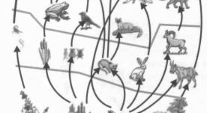
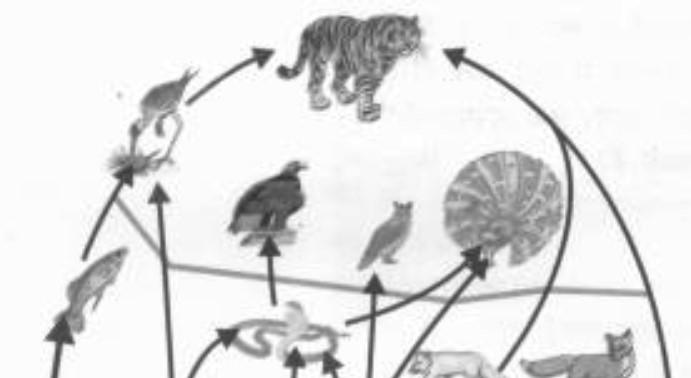
Followingtrophiclevelscanbeidentifiedinafoodchain
Autotrophs
Herbivores
Carnivores
Omnivores
Decomposers
Theyaretheproducersoffoodforallotherorganismsoftheecosystem.Theyarelargelygreen plantsandconvertinorganicmaterialinthepresenceofsolarenergybytheprocessof photosynthesisintothechemicalenergy(food).
Theanimalswhicheattheplantsdirectlyarecalledprimaryconsumersorherbivorese.g., insects,birds,rodentsandruminants.
Theyaresecondaryconsumersiftheyfeedonherbivoresandtertiaryconsumersiftheyuse carnivoresastheirfood.e.g.,frog,dog,catandtiger.
Animalsthateatbothplantandanimalse.g.,pig,bearandman
Theytakecareofthedeadremainsoforganismsateachtrophiclevelandhelpinrecyclingof thenutrientse.g.,bacteriaandfungi.
Typesoffoodchains
Inanecosystem,thetwochainsareinterconnectedandmakey-shapedfoodchain.Thesetwotypesoffood chainsare:-
(i)Grazingfoodchains:Itstartsfromthegreenplants thatmakefoodforherbivoresandherbivoresinturn forthecarnivores.
(ii)Detritusfoodchains:Itstartsfromthedeadorganic mattertothedetrivoresorganismswhichinturnmake foodforprotozoantocarnivoresetc.
Trophiclevelsinanecosystemarenotlinearrather theyareinterconnectedandmakeafoodweb.Thus, foodwebisanetworkinterconnectedfoodchains existinginanecosystem.Oneanimalmaybea memberofseveraldifferentfoodchains.Foodwebs aremorerealisticmodelsofenergyflowthroughan ecosystem.
Ecosystemsarecapableofmaintainingtheirstateof equilibrium.Theycanregulatetheirownspecies structureandfunctionalprocesses.Thiscapacityof ecosystemofself-regulationisknownashomeostasis. Inecology,thetermappliestothetendencyfora biologicalsystemtoresistchanges.
103|Page Section3:EnvironmentalPlanningandDesign
Foodweb HomeostasisofEcosystem
FoodWeb
3.2EcologicalPrinciples
3.2.1Ecologicalpyramid
Ecologicalpyramidsarethegraphicrepresentationsoftrophic levelsinanecosystem.Theyarepyramidalinshapeandtheyare ofthreetypes:Theproducersmakethebaseofthepyramidand thesubsequenttiersofthepyramidrepresentherbivore,carnivore andtopcarnivorelevels.


3.2.2EcologicalEfficiency
Inanecosystemthattheamountofenergydecreasesateach subsequenttrophiclevel.Thisisduetotworeasons:
1.Ateachtrophic,apartoftheavailableenergyislostin respirationorusedupinmetabolism.
2.Apartofenergyislostateachtransformation,i.e.,whenitmoves fromlowertohighertrophiclevelasheat.
Itistheratiobetweentheamountofenergyacquiredfromthe lowertrophiclevelandtheamountofenergytransferredfrom highertrophicleveliscalledecologicalefficiency.Lindmanin1942 definedtheseecologicalefficienciesforthe1st timeandproposed 10%rulee.g.,ifautotrophsproduce100cal,herbivoreswillbeable tostore10cal.andcarnivores1cal.However,theremaybeslightvariationsindifferentecosystemsand efficiency).
3.2.3EcologicalEquilibrium
Ecosystemalwaysremainsinthestateofequilibrium.Theequilibriumisdynamicisnatureandbioticcomponents appearanddisappeartimetotimeduetotheirdeathorpredator.Inaddition,decomposerconvertsthe complexorganicmatterofdeadplantandanimalsintothesimpleinorganicsubstances.Thesesimpleinorganic substancespassthroughthesoil,plantsandanimalsinacyclicmanner,andthiskeepsthelifegoingoninan ecosystem.Thus,bothbioticandabioticcomponentsareinadynamicstate.
3.2.4EcologicalCommunity:
Anecologicalcommunityisthesetofinteractingspeciesthatmakesupthelivingpartofecosystem.Itisdifficult toknowtheentiresetofspeciesinteractinginsameplaceandfunctioningtogether.Hence,definitioncanbe confinedtoparticularareawherethecommunityconsistsofallthespecieswhethertheyareknowntointeract ornot.Accordingtothis,exampleforecologicalcommunitywouldbetheanimalsinazooplacedindifferent cages.
3.2.5Ecologicalsuccession
Ecosystemchangesovertimeandspace,thenareaswithoutlifeonearthcanbefilledwithlivingbeings.This changingnatureofcommunitiesandtheirabilitytorecoverfromdisturbanceinecosystemiscalledecological succession.Therearetwostagesofsuccession.
104|Page
ArchitectsGuidebookforCompetitiveExamsbyAr.SwapnilS.Vidhate
EcologicalPyramid
4.1.1HistoricalexamplesofUrbanDesign
TheancienttreatiessuchasManasaraandVastushastradescribethebuiltformandurbancharacterofthecity planningandurbandesignprinciplesandfunctionalandenvironmentalrelationships.Thereare8typesofvillage /cityplans (GATE-2016,2013,2011,2008,2004,2002,1998)
Dandaka
Streetsarestraightandcrosseachotheratrightanglesatthecenter
Villagehas4gatesonfoursides
Villageisrectangular/square


Widthofthestreetvariesfromone-fivedanda
2transversestreetattheextremitieshavesinglerowofhouses
Thevillageofficeslocatedintheeast.
thefemaledeity/chamadevatalocatedoutsidethevillageandthemale deitiesinthenorthernportion
Sarvotobhadra
Thistypeoftownplanisapplicabletolargervillagesandtowns,whichhave tobeconstructedonasquaresite.
Accordingtothisplan,thewholetownshouldbefullyoccupiedbyhouses ofvariousdescriptionsandinhabitedbyallclassesofpeople. Thetempledominatesthevillage.
Nandyavarta
Thisplaniscommonlyusedfortheconstructionof townsandnotforvillages.
Itisgenerallyadoptedforthesiteseithercircular orsquareinshape,30004000houses. Thestreetsrunparalleltothecentraladjoining streetswiththetempleofthepresidingdeityin thecenterofthetown.
ofwhichisfollowedinthislayout.
Padmaka
Thistypeofplanwaspracticedforbuildingofthetownswithfortressall round.
Thepatternoftheplanresemblesthepetalsoflotusradiatingoutwardsfrom thecenter.

Thecityusedtobepracticallyanislandsurroundedbywater,havingno scopeforexpansion.

133|Page Section4:UrbanDesign,LandscapeandConservation
,theform
4.1Historicalandmodernexamplesofurbandesign
Swastika

Swastikatypeofplancontemplatessomediagonalstreetsdividingthesite intocertainrectangularplots.

Thesiteneednotbemarkedoutintoasquareorrectangleanditmaybeof anyshape.
Arampartwallsurroundsthetown,withamoatatitsfootfilledwithwater. Twomainstreetscrosseachotheratthecenter,runningsouthtonorthand westtoeast.
Prastara
Thecharacteristicfeatureofthisplanisthatthesitemaybeeithersquareor rectangularbutnottriangularorcircular.
Thesitesaresetapartforthepoor,themiddleclass,therichandthevery rich,thesizesofthesitesincreasingaccordingtothecapacityofeachto purchaseorbuildupon.
Themainroadsaremuchwidercomparedtothoseofotherpatterns. Thetownmayormaynotbesurroundedbyafort.
Karmukha
Thisplanissuitablefortheplacewherethesiteofthetownisintheformofa boworsemicircularorparabolicandmostlyappliedfortownslocatedon theseashoreorriverbanks.
Themainstreetsofthetownrunfromnorthtosouthoreasttowestandthe crossstreetsrunatrightanglestothem,dividingthewholeareaintoblocks. Thepresidingdeity,commonlyafemaledeity,isinstalledinthetemplebuild inanyconvenientplace.
Chaturmukha
Chaturmukhatypeofplanisapplicabletoalltownsstartingfromthelargest towntothesmallestvillage.
Thesitemaybeeithersquareorrectangularhavingfourfaces. Thetownislaidouteasttowestlengthwise,withfourmainstreets. Thetempleofthepresidingdeitywillbealwaysatthecenter.

134|Page
ArchitectsGuidebookforCompetitiveExamsbyAr.SwapnilS.Vidhate
TheSumeriansdevelopeda numberofcitiessurrounded byagriculture.Theyshared thesameculture,but organizedthemselves independently.
Themajorcitiesdeveloped bySumeriansinclude:Ur, Kish,Lagash,Nippur,Uruk andEridu.
Urbecamethecapitalof thewholeofsouthern Mesopotamiaunder Sumeriankings.
Excavationproducedroyal tombs(Ziggurats)containing gold,silver,bronzeand semipreciousstones


ThecitywascapitalofNeoBabylonianEmpireunder NebuchadnezzarIIbetween 604to561BC.
Thecitywasplannedinan areaof400hawitha populationof100,000and wasofsquareshapedivided bytheriverEuphrates.


Thecitywasfullofhouses, threetofourstoryhighand havebeenlaidoutwithits streetsstraight,notably thosewhichrunatright anglesandleadtotheriver.
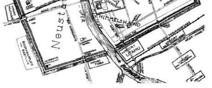

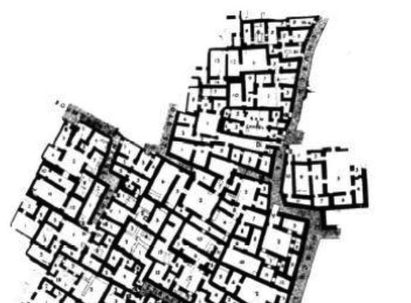
135|Page Section4:UrbanDesign,LandscapeandConservation
MerkesQuarter-Babylon
4.1.2UrbanDesign/TownPlanningofMesopotamia
TheCitiesofSumer
TheCityofBabylon
TemplecomplexatUR
HousingdistrictatUR
PlanningofBabylon
TheearliestremainsofPersepolisdatefromaround 515BC.ThecitywasknownasParsawhichmeans

Thegreatcomplexwascreatedbyatleastthree PersianMonarchs(Darius,Xerxes,Artaxerxes)as oneofthecapitalsofthePersianEmpire.Itsruins revealarchitectureinfluencesfromothercultures inMesopotamia.
Persepoliswasbuiltinterracesfromtheriver Pulwarandroseover125,000sq.ft.beingpartlycut intothemountain.
Themainfeaturesofurbandesignincluderegular shapemonumentalstaircases,bigperistyle (columnedhalls).

XerxesIbuiltagreatpalacewhichconsistedofa grandhallthatwas82ft.longwithfourlarge columnsontheentrance.
Averybigcisternwascarvedattheeasternfootof themountaintocatchtherainwatersopeople couldbatheanddrink.
Thewallsbuiltaroundthecitymadeiteasyto defendanysection.Thewallswereveryhigh,and hadfortifiedtowers.
ThecitywasdestroyedbyAlexanderthegreat.
TheCityofKahun(Egypt,2000BC)
Thetownwaserectedfortheworkmenemployed inconstructingthenearbypyramidanditwas abandonedwhenthepyramidwascompleted Thetownwassquareinshapewiththestreets runninginthenorth-southandeast-westgrid pattern.
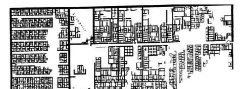
Thehouseswerebuiltofmudbrickhaving beamed,flatmudroofs,opencourtsand porticoesandtheearliestexamplesofsupporting woodencolumn,flutedandonaraisedbase.

(GATE-2016,2013)
136|Page
ArchitectsGuidebookforCompetitiveExamsbyAr.SwapnilS.Vidhate TheCityofPersepolis
GreatComplexofPersepolis
PlanofKahun
Thestudyofurbanlandusegenerallydrawsfromthreedifferentdescriptivetheories/models.
1.ConcentricZonetheory.
2.Sectortheory.
3.Multiplenucleitheory.


Thesemodelsweredevelopedtogeneralizeaboutthepatternsofurbanlandusefoundinearlyindustrialcities oftheU.S.Asthesearegeneralmodelsdevisedtounderstandtheoverallpatternsoflanduse,noneofthem canaccuratelydescribepatternsofurbanlanduseinallcities.Infact,allofthesemodelshavebeencriticized forbeingmoreapplicabletocitiesintheU.S.thantocitiesofothernations.
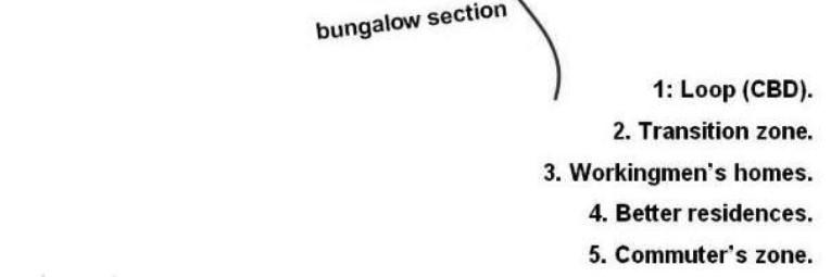
1.ConcentricZonetheory(GATE-2017,2007,1993)
Theory-Theconcentriczonemodelwasamongtheearlydescriptionsofurbanform.
OriginatedbyEarnestBurgessinthe1920.Theconcentriczonemodeldepictstheuseof urbanlandasasetofconcentricringswitheachringdevotedtoadifferentlanduse.The modelportrayshowcitiessocialgroupsarespatiallyarrangedinaseriesofrings.Burgess describedthechangingspatialpatternsofresidentialareasasaprocessof"invasion"and "succession".

1.CentralBusinessDistrict(CBD)-Thisareaofthecityisanon-residentialarea.Thisareaiscalleddowntown,a lotofskyscrapershousesgovernmentinstitutions,businesses,stadiums,andrestaurantsarefound.
2.ZoneofTransition-Thezoneoftransitioncontainsindustryandhaspoorer-qualityhousingavailable.Created bysubdividinglargerhousesintoapartments.
3.Zoneoftheworkingclass-Thisareacontainsmodestolderhousesoccupiedbystable,workingclassfamilies. Alargepercentageofthepeopleinthisarearent.
4.Zoneofbetterresidence-Thiszonecontainsnewerandmorespacioushouses.Mostlyfamiliesinthemiddleclassliveinthiszone.
-Thisareaislocatedbeyondthebuild-upareaofthecity.Mostlyupper-class residentsliveinthisarea.
Assumptionsofthetheory
Olderbuildingsaresituatedinthecitycenter. Newerbuildingsaresituatedatedgeofcity. Landvaluesarehighestincitycenter.
Strongeconomicandethnicsegregationisexisting.
Low-incomegroupslacktransportandliveclosetocitycenter. Citiesdeveloponaflatplainwithequalaccesstotransport.
Achievementsofthetheory
Thisledtoademand-dominatedmodelinwhichdemandforbetterhousingdrivesthewealthiestawayfrom theaginganddecayinghousingneartheindustrializingcitycentertowardtheperiphery. Thisleadstoinvasionofthebestlandbythoseresidentsandindustriesthatcanaffordit.
Thecentralbusinessdistrict(CBD)expandsintothesurroundingtransitionzone.Theresultisthatnatural areas
175|Page Section5:PlanningProcess
5.1SalientConcepts,theoriesandPrinciplesofUrbanPlanning
ArchitectsGuidebookforCompetitiveExamsbyAr.SwapnilS.Vidhate
Criticismofthetheory
Itassumesanisotropicplain. Landmayrestrictgrowthofcertainsectors. Themodeldoesnotfitpolycentriccities.
ItdescribesthepeculiarAmericangeography,wheretheinnercityispoorwhilesuburbsarewealthy.
Exampleofthetheory
Burgessappliedhismodel toChicago,asshownin thediagram.Thecitycore wasdestroyedinthe GreatFireof1871andas thecitywasrebuilt,social patterningevolvedand Chicagobecamea segregatedcitywith concentriczones.By1910, 78%ofAfricanAmerican livedinthedilapidated housingalongtheBlack Belt.

Todaygentrificationschemesareoccurringinthenearwestand southsidesofChicago.Gentrificationisthe processwherebyolddeterioratedindustrialorlow-classhousing areasareregenerated.

Theory-SoonafterBurgessgeneralizedabouttheconcentriczoneformofthecity, HomerHoytre-casttheconcentricringmodel.In1939,Hoytmodifiedtheconcentric zonemodeltoaccountformajortransportationroutes.Recallthatmostmajorcities evolvedaroundthenexusofseveralimportanttransportfacilitiessuchasrailroads,sea ports.Hoyttheorizedthatcitieswouldtendtogrowinwedge-shapedpatterns,orsectors, radiatingfromtheCBD.Hoyt'ssectormodelissimplyaconcentriczonemodelmodified toaccountfortheimpactoftransportationsystemsonaccessibility.


176|Page
2.Sectortheory(GATE-2017,2007)
7.1FireFightingSystems
7.1.1TypesofFire
Firescanbegroupedasfollowsbasedonthecauseoffire:
A.Solidfuels,e.g.,wood,paper,cloth,etc.
B.Flammableliquids,e.g.,petrol,oil,paints,fats,etc.(UPSC-CPWD-2015)
C.Flammablegases,e.g.,methane,propane,acetylene,etc.
D.Flammablemetals,e.g.,zinc,aluminum,uranium,etc.
E.Electricalequipment.
F.Unsaturatedcookingoils.
7.1.2FireExtinguishers
Aportablefireextinguishermustcontainthetypeoffireextinguishingagentsuitableforthefireitisrequiredto extinguish.Itmustalsobeclearlyidentifiablebycolorcodingforitsintendedpurpose.
ExtinguishingagentExtinguishercolor
Application
Water Red CarbonaceousFires,paper,wood,etc.
Foam RedwithcreambandCarbonaceousfires,paper,woodaswellasflammableliquids, oils,fats,etc.
CarbondioxideRedwithblackbandElectricalfiresandflammableliquids

DrychemicalsRedwithblueband Allfires.
7.1.3FireSprinklers
7.1.3.1Sprinklers
Watersprinklersprovideanautomaticspraydedicatedtotheareaoffireoutbreak.Sprinklerheadshave temperaturesensitiveelementsthatrespondimmediatelytoheat,dischargingthecontentsofthewatermain towhichtheyareattached.
Inadditiontoarapidresponsewhichreducesandisolatesfiredamage,sprinklersuselesswatertocontrola firethanthefirefightingservice,thereforepreventingfurtherdamagefromexcesswater.
Thesimplestapplicationistoattachandsuspendsprinklerheadsfromawatermainfixedatceilinglevel. However,somemeansofregulationandcontrolisneeded.
Sprinklerheadspacing-Areacoveredbyonehead, maximum12m2
Maximumdistancebetweenheads-4m
Maximumdistancefromwalltoceilingmounted head-2m.
Minimumdistancebetweenheadsinthesame room-2m(only1headperroomisnormal).
Operatingpressure-Minimum0.5bar(50kPa).
217|Page Section7:ServicesandInfrastructure
7.1.3.2PipedistributiontoSprinklers
Thearrangementofpipeworkwilldependonthebuildingshapeandlayout,thepositionoftheriserpipeand thenumberofsprinklerheadsrequired.Toprovideareasonablybalanceddistribution,itispreferabletohavea centerfeedpipe.Inpracticeitisnotalwayspossibleandendfeedarrangementsareused.

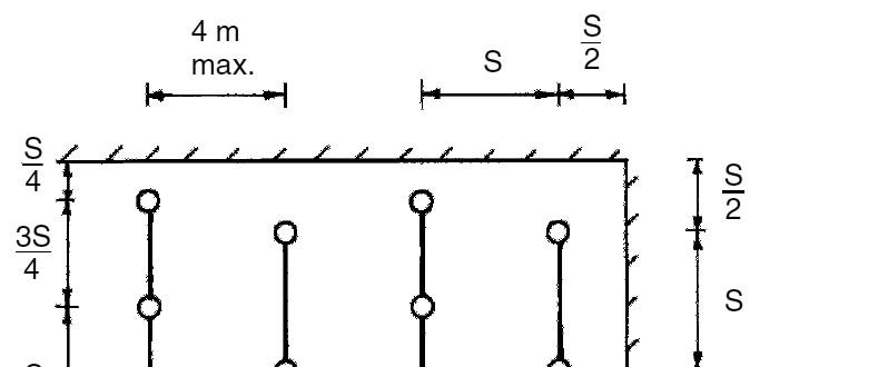
7.1.3.3SpacingCalculationsofSprinklers
a.Staggeredarrangementof sprinklerheadsonanordinary hazardinstallation:
b.Calculatingthenumberof sprinklerheads:
e.g.,anordinaryfirehazard categoryforafactoryhavinga floorarea20mX10m.
Area,20X10=200m2 .

Ordinaryhazardrequiresa maximumservedfloorareaof12 m2 persprinklerhead.
Therefore:200÷12=16.67i.e.,at least17sprinklerheads.
Forpracticalpurposes,18couldbe installedasshowninbelowfigure:
Themaximumareaservedbyeachsprinklerhead=3.33mX3.33m=11.1m2 .
Thisissatisfactory,beinglessthan12m2 .
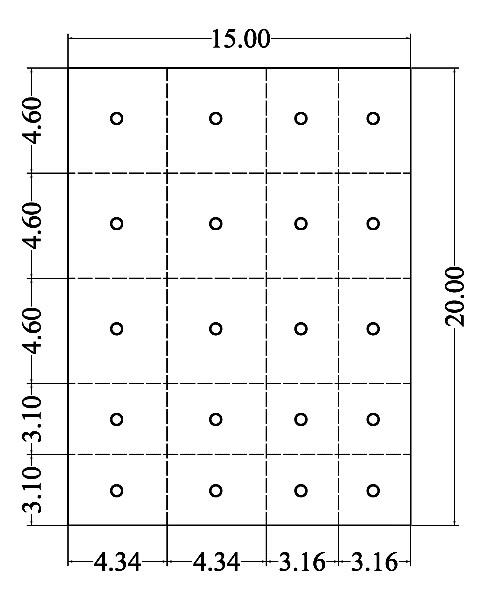
Example:Iftheareacoverageofonesprinkleris20m2,withamaximumandminimumspacingof4.6mand1.8 mrespectively,theminimumnumberofsprinklersrequiredtobearrangedinaregularorthogonalgridtocover theareaofa15mx20mroomwouldbe_______(GATE-2013)
Explanation:
ToProvideminimumnumberofsprinklersinaroomofdim.15mX20m, eachcoveringareaof20m2,withmaximumandminimumspacingof 4.6mand1.8mrespectively,thefollowingstepsshouldbeadopted.
1.Markthegridof4.60mX4.60malongwidthandlength.Buthere, areabetweengridswillformsquarehavingareaof21.16m2 Whereas.themaximumareaonesprinklercancoveris20m2 asper giveninformation.

2.Thus,thegridalongshortersideshouldbechanged,insuchaway thatthesquareswhichwillbeformedbetweenthem,willhavearea of20m2 orlessthanthat.
3.Minimum20sprinklerscanbeprovidedwiththegridasshownin theadjacentfigure.
218|Page
ArchitectsGuidebookforCompetitiveExamsbyAr.SwapnilS.Vidhate
B1.1.1PrinciplesofArtandArchitecture
B1.1.2WorldHistoryofArchitecture
1.1.2.1PrehistoricPeriod&Architecture
StructureMenhir(Monolith)

Description
Theseareenormousstone pillars,withaheightfrom3 to20meters,placed verticallyintheground(the largestoneweighed300 tons)(GATE-2009).
Dolmens
Thesearelarge,stonestructures, placedhorizontallyontopofa stonebase,oraclosedstone boxwithacircular(mostoften), triangular,orsquareentrance (GATE-2009).
Cromlech(Stonehenge)


Thesearecirclesofstone.A seriesofuprightstones arrangedinacircleand supportinghorizontalslabs.
Structure
1.1.2.2EgyptianArchitecture
StructureGreatPyramidofCheops(Kufu)

TempleofKhons,Karnak
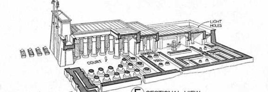
Description
ThegreatpyramidofCheopsissquareonplan, 760feeteachway,itsareaabout13acres.The facesofthepyramidareequilateraltriangles laidslopingandmeetinginapoint.Twoair channelsledtotheouterfaceofthepyramid forventilation.Thereweretwochambersinthe pyramid,oneknownasthe connectedwithapassageleadingoffthatto the andtheotherbelowthe ground.(GATE-2014)
Theentrancetothetemplewasbetween ormassiveslopingtowers,oneachside ofthecentralgateway.Theentranceleadsto thelargeoutercourtyardwhichwasopento skyinthecenter.Thiscourtyardwassurrounded byadoublecolonnadeonthreesides,andled uptotothehypostylehall,inwhichlightwas admittedthroughclerestoryabove,formedby thedifferentheightofthecolumns.(GATE2015,2009,2006)
Structure
261|Page SectionB1.1:HistoryandContemporaryArchitecture
Thissectionisalreadycoveredinthe
ArchitectsGuidebookforCompetitiveExamsbyAr.SwapnilS.Vidhate


Structure
Description
Mastaba(TombStructure)


Itisaflat-roofed,rectangularstructurewith inwardslopingsides,constructedoutofmudbricks.Mastabaswereoftenaboutfourtimes aslongastheywerewide,andmanyrosetoat least30feetinheight.Theywerebuiltwitha north-southorientation.InsidetheMastaba,a deepchamberwasdugintothegroundand linedwithstoneandbricks.Theburial chamberswerecutdeep,untiltheypassedthe bedrock,andwerelinedwithwood.(GATE2018,UPSC-CPWD-2016)

Pylons
Itwasadepictionoftwohills"betweenwhich thesunroseandset.Itwasasymbolic architectureofacultbuildingwhichwas associatedwiththeplaceofrecreationand rebirth.(GATE-2014,2009)
Structure
1.1.2.3AssyrianArchitecture


Structure
Ziggurat


ThePalaceofSargon,Khorsabad
Description
Thesetempleswerebuiltindiminishingstages ofmasonrywithbuttressedwall.Theywere severalstoriesinheightandconstructedwith coloredglazedbricks.Awalledenclosure surroundedthewholestructure.Theanglesof thesetemplesweremadetofacethecardinal pointwhichwascontrastingtotheEgyptian pyramids.(GATE-2018)


Thepalacewasraiseduponaterraceor platformofbrickworkfacedwithstone,46feet abovetheplain,fromwhichitwasreachedby meansofbroadstairwaysandslopingplanes orramps.Thepalacecontainedthreedistinct groups Apartment),TheHarem(PrivateApartment) andTheKhan(ServiceChambers)arranged roundahugecourtyard.Thetemple observatorywassituatedonthewesternsideof theplatform.
Structure
262|Page
Type Description
Inverted arch footings


Continuous footings
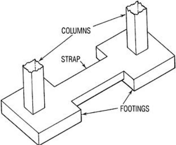

Thistypeoffootingisusedonsoftsoils toreducethedepthofthe foundation.Loadsaboveanopening aretransmittedfromsupportingwalls throughinvertedarchestothesoil.In thistypeoffootings,theendcolumns mustbestableenoughtoresistthe outwardpressurecausedbythearch action.However,withtheadventof RCC,invertedarchconstructionis rarelydoneatpresent.
Inthistypeoffootingasingle continuousR.C.Slabisprovidedas foundationoftwoorthreeormore columnsinarow.Thistypeoffooting issuitableatlocationsliableto earthquakeactivities.Thisalso preventsdifferentialsettlementsin structures.(ISRO-2018,2019)
Illustration
Strapor Cantilever footings

Strapfootingconsistsoftwoormore individualfootingsconnectedbya beamcalledstrap.Thistypeof footingisusedwherethedistance betweenthecolumnsissogreatthat thetrapezoidalfootingbecomes quitenarrowwithbendingmoments.
Grillage footing
Raft Foundations
Thistypeoffootingsisusedtotransmit heavyloadsfromsteelcolumnsto thesoilshavinglowbearingpower Thistypeofarrangementsprevents deepexcavationsandprovides necessaryareaatbasetoreduce theintensityofthepressure.
Araftormatisacombinedfooting thatcoverstheentireareabeneatha structureandsupportsallthe columns.Theyareusedwherethesoil masscontainscompressiblelensesso thatthedifferentialsettlementabove highlycompressiblesoilsbymaking theweightofthestructureandraft approximatelyequaltotheweightof thesoilexcavated.Theraftis composedofreinforcedconcrete beamwitharelativelythinslab underneath.(GATE-2005)
321|Page SectionB1.2:BuildingConstructionandStructuralSystems
b.Deepfoundations:Thesefoundationscarryloadsfromastructurethroughweakincompressiblesoilsorfillsonto thestrongerandlesscompressiblesoilsorcracksatdepth.Thesefoundationsareingeneralusedasbasements, buoyancyrafts,caissons,cylinders,shaftandpiles.Someofthemaredescribedbrieflybelow.

Type Description
Buoyancy Rafts
Theyarehollowsubstructuresdesigned toprovideabuoyantsubstructure beneathwhichreducenetloadingson thesoiltothedesiredlowdensity.
Illustration
Caissons


Shaft foundations
hugeboxmadeupofreinforced concrete.Theyarehollowsubstructures frominsidedesignedtobeconstructed onornearthesurfaceandthensunkas singleunitstotheirrequiredlevel.Itisthe foundationusedfortheconstructionof bridges,piers,abutmentsinriver,and dockstructureinverydeepwater. Caissonsareclassifiedintothreetypes: Open,box&pneumaticcaissons.
Theyareconstructedwithindeep excavationsupportedbylining constructedinplaceandsubsequently filledwithconcrete.Thedrilledshaft foundationsaredividedintotwotypes: Endbearing(Theaxialloadresistanceis basedonthecapacityofthesubsurface conditionsatthetiporbaseofthedrilled shaft.)&Side(Skin)friction(Theaxialload resistanceisbasedonthecapacityof thesubsurfaceconditionsalongthesides /surfaceareaofthedrilledshaft)

Pile Foundations
Thepilefoundationisaconstruction supportedonpiles.Apileisanelement ofconstructioncomposedoftimber, concreteorsteeloracombinationof them.Thepilesmaybeplaced separatelyortheymaybeplacedin formofaclusterthroughoutthestructure. Thepilesareclassifiedbasedonfunction (Bearingpile,FrictionPile,ScrewPile, CompactionPile,UpliftPile,BatterPile andSheetPile)andmaterials& composition(Cementconcretepiles, timberpiles,steelpiles,sandpilesand compositepiles).(GATE-2005)
322|Page
CompetitiveExamsbyAr.SwapnilVIdhate
1.3.1.1.SolarChart
SolarChart(Sunpath)consistsof4linesoffollowingtypes(GATE-2018):
Azimuth Lines Azimuthanglesrunaroundtheedgeof thediagram.
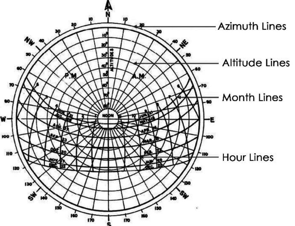
Altitude Lines
Altitudeanglesarerepresentedas concentriccirculardottedlinesthatrun fromthecenterofthediagramout.
Date/Month Lines
Datelinesstartontheeasternsideofthe graphandruntothewesternsideand representthepathofthesunonone particulardayoftheyear.InEcotect,the firstdayofJanuarytoJuneisshownas solidlines,whileJulytoDecemberis shownasdottedlines.
HourLines/ Analemma
Hourlinesareshownasfigure-eight-type linesthatintersectthedatelinesand representthepositionofthesunata specifichouroftheday.Theintersection pointsbetweendateandhourlinesgive thepositionofthesun.
1.3.1.2SolarReflectanceandAbsorptance
Thesolarreflectanceisthefractionofsolarradiationreflectedbyroof.Thecomplementofreflectanceis absorptance;whateverradiantenergyincidentonasurfacethatisnotreflectedisabsorbedintheroof.The reflectanceandabsorptanceofbuildingmaterialsareusuallymeasuredacrossthesolarspectrum,sincethese areexposedtothatrangeofwavelength.
Reflectanceismeasuredonascaleof0to1,with0beingaperfectabsorberand1beingaperfectreflector. Absorptanceisalsoratedfrom0to1,andcanbecalculatedfromtherelation: Reflectance+Absorptance=1.
1.3.1.3EmissivityorThermalEmittance
atedbyaparticular materialtoenergyradiatedbyablackbodyatthesametemperature. radiatetheabsorbedenergy.Atrueblackbodywouldhaveane=1whileanyrealobjectwouldhavee<1. Emissivityisadimensionlessquantity(doesnothaveunits).Ingeneral,thedullerandblackeramaterialis,the Themorereflectiveamaterialis,theloweritsemissivity.
1.3.1.4CoolRoofs
Inhotclimates,coolroofs(orhighemissivityorthermalemittanceroofsurfaces)areaneffectivewaytoreduce reducetheneedforairconditioningandmakebuildingsmorecomfortabletothepeopleinside.Thelightcolor reflectssunlightandheatawayfromthebuilding,andthehighemissivityorthermalemittanceallowsheatto escapetotheatmospherewhenthesurfacebecomesheated.Althoughsomesurfaces,suchasgalvanized metal,haveahighreflectance,theyhavealowemittance.Thesesurfacesreflectheat,butheatthatis absorbedcannotescape.Othersurfaces,suchasdarkpaint,haveahighemittancebutalowreflectance. Thesesurfacesallowheattoescape,butdoapoorjobofreflectingheatthatstrikesthesurface.
447|Page SectionB1.3:BuildingServicesandSustainability
1.3.1Solararchitecture
SolarChart
1.3.1.5UrbanHeatIsland
AnUrbanHeatIslandisametropolitanurbanarea,whichissignificantlywarmerthanitssurroundings.As populationcentersgrowinsize,theytendtohaveacorrespondingincreaseinaveragetemperature.Scientists refertothisphenomenonastheUrbanHeatIslandEffectThetwomaincausesoftheurbanheatislandare modificationofthelandsurfacebyurbandevelopmentandwasteheatgeneratedbyenergyusage.One consequenceofurbanheatislandsistheincreasedenergyrequiredforairconditioningandrefrigerationincities thatareincomparativelyhotclimates.(GATE-1995,1993).
1.3.1.6VisualLightTransmittance
VisualLightTransmittance(alsoknownasVisualTransmittanceVT)isdefinedastheratiooflightthatpasses throughtheglazingtothelightpassingthroughperfectlytransmittingglazing.Inotherwords,italsoreferstothe fractionofvisiblelighttransmittedthroughtheglazing.VLTaffectsenergyconsumptioninbuildingbyproviding daylightthatcreatestheopportunitytoreduceelectriclightinganditsassociatedcoolingloads.Glazingwithlow SHGCgenerallyhasalowVLT;however,iftheVLTistoolow,theoutsideviewfrominsidethebuildingwillbe impaired.WithlowerVLT,thedaylightingintheinteriormayalsoreducetoalevelthatmayrequiresupplemental occupants.Thus,buildingswithlowerwindowtowallratios(WWR),mayneedhigherVLT.
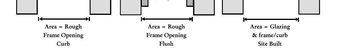
1.3.1.7Skylights
Askylightisafenestrationsurfacehavingaslopeoflessthan60degreesfromthehorizontalplane.Other fenestration,evenifmountedontheroofofabuilding,isconsideredverticalfenestration.Skylightscanbe installedintoaroofsystemeitherflush-mountedorcurb-mounted(includingsitebuilt).Inordertocreatea
1.3.1.8Brise-Soleil


Itisthesolarprotectionsystemconsistingoffixedslatsorgrids, placedoutsidethebuildingfacadeinfrontofopenings.Itshieldsthe interiorofthebuildingbyregulatingthedirectsunrayscomingfrom theexternalside(GATE-2019,2006,UPSC-CPWD-2015,2016).

448|Page CompetitiveExamsbyAr.SwapnilVIdhate
Brise-Soleil
2.1.1Regionaldelineation,SettlementHierarchy,TypesandHierarchyofPlans
2.1.1.1Regionaldelineation
Regionscanbeclassifiedbasedonparameterssuchas,EnvironmentandLandSuitability,Demographic,Quality ofLife,Flows(Supplyofrawmaterials,finishedgoods,floatingpopulation,finance),Economic&Investments, others.
Forplannedandsustainabledevelopmentofthehumansettlements,theregionalplanningapproachneedsto bepromoted.Theplanningregionscouldbeclassifiedunderthreeheads:
(a)AdministrativeRegions:whichcanbeDistrictRegionsorMetropolitanRegionsaspertherecommendationsof the73rd &74th ConstitutionalAmendmentAct,
(b)InvestmentRegions:whichcanbenewinvestmentmanufacturingzones,industrialandfreightcorridors, specialinvestmentregionsetc.TheycouldbeidentifiedunderNationalActs/policies,
(c)Specialregions:whicharesensitiveintermsofenvironment/socioeconomicorpoliticalaspects.
2.1.1.2SettlementHierarchy
ThissectionisalreadycoveredintheSection5.1- .
2.1.1.3PlanningProcess
Planning
Planningisauniversalhumanactivity,abasicsurvivalskillinvolvingtheconsiderationsofoutcomesbefore choosingamongalternatives.
Planningisconsideredwithland
Allinformationconcerningland,itsshape,fertility,appearanceandvalueisofdirectinteresttotheplanner.This includesgeographical,economicandvisualmattersandthesearethethreemaindivisionswhichappearand reappearinallthesubjectsinvolvedwiththeadditionofafourth,thesecondaspect,whichismingledwith, distinguishablefromtheeconomicaspects.
PlanningProcess
6.Design
2.DefiningtheObjectives
Toregulategrowth,tonullifythebadeffectsofpast growth,toimprovethetransportationfacilities,to optimizetheresourcesutilization,tobalancepopulation andeconomicactivities,topromotesocialintegration amongdifferentcategories,topromoteaconvenient comfortable,beautifulandhealthyenvironment.
3.DataCollection(StudiesandSurveys)
Identificationoftrendanddirectionofgrowth,Traffic survey,Studyondemography,Climate,Resourcesand otherpotentials.
4.DataAnalysis
Intheformofstudymaps,graphs,charts,etc.andlong term&short-termobjectivesareidentified.
5.Forecasting
Demographicprojection&forecastingbasedon migration,employment,industrializationand urbanization.
Preparationofdevelopmentplans,formulationof zones,alterationtotheexistingzoningregulations, wideningofroadsetc.
7.FixingthePriorities
Identificationofprioritiesbasedontheneed, importanceandurgency.
8.Implementation
Implementationbythesuitableauthorities,within time&mustsatisfyalltherequiredobligations.
9.Review,EvaluationandFeedback
Monitoringbyperiodicalinspections,feedbacks& reviewreports.
511|Page SectionB2.1:RegionalandSettlementPlanning
1.IdentificationandDefinitionofProblem
2.1.1.4Types&HierarchyofPlans
MasterPlan
Thiscanbereferredasmasterkeytothesituationasitisthecomprehensiveschemeofdevelopmentthat includesthegeneralfundamentals.Thecolorcodesusedinmasterplanfordifferentlandusesareasfollows
Landuse Color
Residential Yellow Commercial Blue Industrial Violet
PublicandSemiPublic Red
Recreational Green Transportation Grey
Publicutilitiesandfacilities Brown
CityDevelopmentPlan
CitydevelopmentPlan(CDP)isdefinedunderJNNURMasoneoftheguidelinestoavailfundsunderit.Itenlists theobjectivesofcitydevelopmentandapproachforpreparationofthesame.(GATE-2014,2010,UPSC-CPWD2015)
StructurePlan
Astructureplanwhichsinglesoutforattentionofcertainaspectsoftheenvironmentusuallythelanduses,the mainmovementsystemsandthelocationofcriticalfacilitiesandbuildings.Suchaplanaimstoinfluence andperhaps shouldnotbedecidedattheoutset.
ZonalPlan
AZonalDevelopmentPlanmeansaplanforaZone(Division)ofthelargerarea.TheZonalPlan(DivisionalPlan) detailsoutthepolicyoftheMasterPlanandactsasalinkbetweenthelayoutandtheMasterPlan.The developmentschemes/layoutplansindicatingusepremisesshouldconformtotheMasterPlan/Zonal
ActionAreaPlan
ActionAreaPlansarerequiredtobepreparedforvariousareasthroughouttheCountypriortothesubmission ofplanningapplicationsfordevelopmentonthoselands.ThegeneralpurposeforActionAreaPlansistoensure thatdevelopmentisundertakeninasustainableandintegratedmanner.Anactionareaplanshouldsetdown theframeworkforthesustainable,phasedandmanageddevelopmentofaparticulararea.
TownPlanningScheme
TownPlanningschememeans,schemesmaybepreparedaspertheprovisionoftherespectiveStateTown PlanningandUrbanDevelopmentActfortheareawhichisinthecourseofdevelopmentlikelytobeandfor buildingpurposeoralreadyupon.Thismethodwasintroducedthrough .Later amendedtoNewBombayTownPlanningAct:1954.TheseactswereinstrumentaltoconceptualizetheTown PlanninginIndia.Rapidlydevelopedareasoutsidethelimitsofurbanauthoritieswererequiredtobedeveloped inplannedmanner.ThebasicconceptofTownPlanningSchemeispoolingtogetherallthelandunderdifferent ownershipsandredistributingitinaproperlyreconstitutedformafterdeductingthelandrequiredfortheopen spaces,socialinfrastructure,services,housingfortheeconomicallyweakersectionandroadnetwork.The processenablesthelocalauthoritytodeveloplandwithoutfullyacquiringitandgivesitapositivecontrolover thedesignandthetimingoftheurbangrowth.ToachievetheobjectivesoftheDevelopmentPlan.Town planningschemesarepreparedgivingmicrolevelplanningforsmallerareasofabout100hectares.Theseareas arealreadyunderthepressureoftheurbandevelopment.T.P.Schemesarejointventurebetweenthelocal authoritiesandtheowneroftheplotswhovoluntarilyagreetopooltheirland,redistributethatlandamongthem andsharethedevelopmentcosts.
512|Page CompetitiveExamsbyAr.SwapnilVIdhate
2.2.1.1AboutRemoteSensingandGIS
2.2.1.1.1RemoteSensing
Remotesensingisdefinedasthescienceandtechnologybywhichcharacteristics ofobjectsofinterestcanbeidentifiedwithoutdirectcontactwithit(GATE-2006) Thereflectedorradiatedelectromagnetic(EM)wavesarereceivedbysensors aboardplatform.ThecharacteristicsofreflectedorradiatedEMwavesdependon thetypeorconditionoftheobjects.
Inactiveremotesensing, activeSensorsareused whichprovidetheirown energysourcefor illumination (e.g., SyntheticApertureRadar (SAR),LaserScanner (LIDAR).Anactivesensor emitsradiationwhichis directedtowardthe targettobeinvestigated.Theradiationreflectedfrom thattargetisdetectedandmeasuredbythesensor.
AdvantagesofActiveRemoteSensing

Theabilitytoobtainmeasurementsanytime, regardlessofthetimeofday,seasonor(weather). Examinewavelengthsthatarenotsufficiently providedbythesun(e.g.,microwaves), Bettercontrolthewaythatatargetisilluminated.

DisadvantagesofActiveRemoteSensing
Activesystemsrequirethegenerationofafairly largeamountofenergytoadequatelyilluminate targets.
InPassiveremote sensing,passive sensorsareused whichmeasure energythatis naturallyavailable (e.g.,Optical sensors).Thesun providesavery convenientsource ofenergyfor passiveremotesensing.Thesun'senergyisreflected forvisiblewavelengths,orabsorbedandthenreemittedforthermalIRwavelengths.
AdvantagesofPassiveRemoteSensing
Passivesystemsrequirelessamountofenergyas theymainlydependuponothersources(e.g.,sun) forenergy.

DisadvantagesofPassiveRemoteSensing
Forallreflectedenergy,thiscanonlytakeplace duringthetimewhenthesunisilluminatingthe Earth.
Energythatisnaturallyemitted(suchasthermal infrared)canbedetecteddayornight,aslongas theamountofenergyislargeenoughtobe recorded.
525|Page SectionB2.2:PlanningTechniquesandManagement
a.ActiveRemoteSensing
b.PassiveRemoteSensing
2.2.1ApplicationofG.I.S.andRemoteSensingtechniquesinUrbanandRegional Planning
A.EnergySourceor Illumination
B.Radiationand theAtmosphere
C.Interactionwith theTarget
D.Recordingof Energybythe Sensor
E.Transmission, Reception& Processing

F.Interpretation andAnalysis
Thefirstrequirementforremotesensingistohaveanenergysourcewhichilluminatesor provideselectromagneticenergytothetargetofinterest.
Astheenergytravelsfromitssourcetothetarget,itwillcomeincontactwithand interactwiththeatmosphereitpassesthrough.Thisinteractionmaytakeplaceasecond timeastheenergytravelsfromthetargettothesensor.
Oncetheenergymakesitswaytothetargetthroughtheatmosphere,itinteractswith thetargetdependingonthepropertiesofboththetargetandtheradiation.
Aftertheenergyhasbeenscatteredby,oremittedfromthetarget,werequireasensor (remote-notincontactwiththetarget)tocollectandrecordtheelectromagnetic radiation.
Theenergyrecordedbythesensorhastobetransmitted,ofteninelectronicform,toa receivingandprocessingstationwherethedataareprocessedintoanimage(hardcopy and/ordigital).
Theprocessedimageisinterpreted,visuallyand/ordigitallyorelectronically,toextract informationaboutthetargetwhichwasilluminated.
Thefinalelementoftheremotesensingprocessisachievedwhenweapplythe informationthatwehavebeenabletoextractfromtheimageryaboutthetarget,in ordertobetterunderstandit,revealsomenewinformation,orassistinsolvingaparticular problem.
2.2.1.1.3ThetermsassociatedwithRemoteSensingarebrieflyexplainedbelow
Term Description
Mostremotesensingimagesarecomposedofamatrixofpictureelements,orpixels, whicharethesmallestunitsofanimage.Pixelsarenormallysquareandrepresenta certainareaonanimage.
Itisimportanttodistinguishbetweenpixelsizeandspatialresolution.Ifasensorhasa spatialresolutionof20mandanimagefromthatsensorisdisplayedatfullresolution, eachpixelrepresentsanareaof20mx20montheground.Inthiscasethepixelsize andresolutionarethesame.However,itispossibletodisplayanimagewithapixelsize differentthantheresolution.Manypostersofsatelliteimageshavetheirpixels averagedtorepresentlargerareas,althoughtheoriginalspatialresolutionofthe sensorremainsthesame.
Commercialsatellitesprovideimagerywithresolutionsvaryingfromafewmetersto severalkilometers.
Generallyspeaking,thefinertheresolution,thelesstotalgroundareacanbeseen.
Aphotographcouldalsoberepresentedanddisplayedinadigitalformatby subdividingtheimageintosmallequal-sizedandshapedareas,calledpicture elementsorpixels,andrepresentingthebrightnessofeachareawithanumericvalue ordigitalnumber.
526|Page CompetitiveExamsbyAr.SwapnilVIdhate
2.2.1.1.2ProcessofRemoteSensing:
G.Application
SpatialResolution
Pixel
2.2.7.1DecisionSupportSystem(DSS)
Itisdefinedasaninteractivecomputer-basedsystemthathelpsdecisionmakerstoutilizedataandmodelsto solvesemistructuredorunstructuredproblems(Gorry&ScottMorton,1971).Thesystemcaptures,stores, processes,displays,organizes,prioritizesandvisualizesthedecisionswithspatialandtemporaldimensions.Ituses computerizedtoolstoanalyzelargeamountsofdataandcomplexrelationsformakingrationaldecisions.
ThefocusofDSSintermsofspatialdataisprovidingflexibleandadaptabletoolsforpolicyanalysisandquick responseratherthanprovidingmodelstoanswerstructuredproblems.
2.2.7.2.GISandDecisionsupportSystem
GISiswidelyusedinlocalandregionalplanningformanaging,integrating,andvisualizingspatialdatasets.GIS providesallthebiophysicalinformationfortheDSS.Theinformationincludesclimate,soilsandtopographicdata andinformationonthefarminfrastructure.However,beyondbasiclevelsofdecisionsupport,GISremainslargely externalartifactstothedecision-makingprocess.ItresultsthatmostGISsoftwarearemoresuitableforproviding limitedoutputsthanasatoolfordecisionsupport.
2.2.7.3.LandInformationSystem
AremotesensingandGISbaseddecisionsupportsystemisefficienttollforobtaininginformationaboutland coverandlandusedata.Landcoverreferstothephysicalcharacteristicsofearth'ssurface,capturedinthe distributionofvegetation,water,soilandotherphysicalfeaturesoftheland,includingthosecreatedsolelyby humanactivitiessuchassettlements,etc.Whereas,landusereferstothewaylandhasbeenusedbyhumans andtheirhabitat,usuallywithaccentonthefunctionalroleoflandforeconomicactivities.LandcoverandLand useanalysisisdonetounderstandthedynamicsoflandusechangesandthecausesforthechanges.These changesmayleadtocriticalecologicalandenvironmentalimpacts.
Thedecisionsupportsystemusedforobtainingdataandtotakefurtherdecisionsaboutlanduseandlandcover changesiscalledasGRDSS(Geographicresourcesdecisionsupportsystem).OneoftheGISplatformsusedfor GRDSSisGRASS(GeographicResourcesAnalysisSupportSystem)whichisanopen-sourceplatform&usedin sustainableresourcesmanagementbyanalyzingthelikelyimpactsassociatedwiththedecisionrelatedtoland usechanges.Ithasthecapabilitiesofvectoranalysis,imageprocessing,datamanagement,statisticalanalysis andspatialmodellingalongwithgraphicsproductionwhichhelpsinvisualizingthedata.Landuseandother naturalresourcemanagementincludingenvironmentalimpactassessment(EIA)canbevisualizedbyGRASSGIS.
a.CadastralMap
Itisamapthatshowstheboundariesandownershipoflandparcels.Somecadastralmapsshowadditional details,suchassurveydistrictnames,uniqueidentifyingnumbersforparcels,certificateoftitlenumbers, positionsofexistingstructures,sectionorlotnumbersandtheirrespectiveareas,adjoiningandadjacentstreet names,selectedboundarydimensionsandreferencestopriormaps(GATE-2002).
b.AerialPhotography
Aerialphotographyisoneofthemostcommon,versatileandeconomicalformsofremotesensing.Itwasthe firstmethodofremotesensing viewoflargeareaswhichenablestoseesurfacefeaturesintheirspatialcontext.
c.ScaleofAerialphotographs
Thescaleofaerialphotographexpressesthemathematicalrelationshipbetweenthedistancemeasuredon thephotoandthecorrespondingdistancemeasuredontheground.Inotherwords,itstatesthatoneunitof distanceonaphotographrepresentsaspecificnumberofunitsofactualgrounddistance.Thescalesmaybe expressedasunitequivalents(1mm=25m),representativefractions(1/25,000)orratios(1:25,000).E.g.,Ifthe scaleofthephotographis1:65,000,then1inchonthephotowouldrepresent65,000inchesonground.The largerthesecondnumberinthescale,smallerthescaleofthemap.Thus,largescalephotographwillprovide detailedandhigh-resolutionviewofasmallareawhereassmallscalephotographwillnot.
545|Page SectionB2.2:PlanningTechniquesandManagement
2.2.7DecisionSupportSystemandLandInformationSystem
E.g.,1.Inasitemap,arectangularplotmeasures150mmx40mm,andthewidthofthefrontroadinthemap measures16mm.Actualwidthoftheroadis4m.IfthepermissibleFARis1.2,themaximumbuilt-upareafor theresidentialbuildingwillbe_____m2 (GATE-2019)
Explanation:
Itisgiventhat,dimensionsofplotonmapis150mmx40mm.Also,widthoffrontroadinthemap=16mm.
Actualwidthoftheroadis4monground.
Itmeansthat,16mmonmapisequalto4m(4000mm)onground.
Thus,1mmonmapisequalto250mmonground.Itmeansthatscaleofthemapis1:250.
Thus,actualdimensionofplotonground=(150x250)mmx(40x250)mm
=37,500mmx10,000mm
=37.5mx10m.(As,1meter=1000mm)
Thus,actualplotarea=375m2
Itisgiventhat,permissibleFAR=1.2.Thus,maximumbuilt-uparea=FARxplotarea=1.2x375=450m2
E.g.,2.Theactualroofareaofabuildingis3,60,000sq.m,whichonasiteplanmeasures25sq.cm.Thescaleof thesiteplanis1:_________(GATE-2015)
Explanation:Assume,thebuildingisofperfectsquaresize.
Itmeasures25sq.cm.ofmap.
Thus.Sideofthesquareonmap=5cm=0.05m
Thus,scaleofthesiteplanis0.05:600=1:12000
d.Photogrammetry
Itisthescienceandtechnologyofobtainingspatialmeasurementsandothergeometricallyderivedproducts withtheuseofphotographs.Theanalysisproceduresrangefromobtainingdistances,area,elevationsusing hardcopyphotographicproducts,equipmentandsimplegeometricconceptstogeneratedigitalelevation models(DEMs)byusingdigitalimagesandanalyticaltechniques.Earlier,itwasmainlyusedinpreparationof topographicmaps.Now-a-days,photogrammetricoperationsareextensivelyusedtoproducearangeofGIS dataproductssuchasthematicdatain2Dand3D,rasterimagesandDEMs,etc. -
representedas:S=d/D
TheScaleofaphotographisdeterminedbythefocallengthofthecameraandtheverticalheightofthelens abovetheground.Thefocallength(f)ofthecameraisthedistancemeasuredfromthecenterofthecamera lenstothefilm.Theverticalheightofthelensabovetheground(H-h)istheheightofthelensabovesealevel (H),minustheheightofthegroundabovesealevel(h).Therelationisexpressedbytheformula: S=f/(H-h)
E.g.,1.Anaircraftflyingatanaltitudeof5000mabovemeansealeveltakesaerialphotographsofaflatterrain havinganaverageelevationof1000mabovemeansealevel.Thescaleofphotographsis1:20000Whatisthe focallengthofthecamera(incm)?(GATE-2012)
Explanation:
Scale(S)= Focallength(f)
{HeightofAircraft(H)-Heightofplaceabovemeansealevel(h)}
Here,S=1/20000,H=5000m,h=1000m.Thus,f=(H-h)/S
f=(5000-1000)/20000=0.2m=20cm
Thus,focallengthofthecamerais20cm.
546|Page CompetitiveExamsbyAr.SwapnilVIdhate


Thank you for taking look inside !
The Complete Book (B&W, Paperback Format) of total 572 pages, can be ordered through(Join for updates related to important study materials & other announcements)