THE ICE AGE UNEARTHED


Preserving the Past, Present, and Future of La Brea Tar Pits

News from SWCA Environmental Consultants Volume 23, Number 1 | 2023
Architectural rendering image
credit: Weiss/ Manfredi and the Natural History Museums of Los Angeles County.


THE ICE AGE UNEARTHED Preserving the Past, Present, and Future of La Brea Tar Pits 4 TREASURED TRASH Preserving an Unexpected Time Capsule of Utah Railroad History 18 WINDS OF CHANGE SWCA Assists Standing Rock Sioux Tribe with Environmental Services for Anpetu Wi Wind Farm 8 FIVE TIPS for Permitting Solar Energy Projects on Bureau of Land Management Land 24 WHEN IT RAINS, IT POURS How One Man’s Con Set the Stage for a River’s Destruction and Restoration 28 SEEING EYE TO EYE How Visual Resources Build Consensus on Sustainable Development 12 CONTENTS SPRING 2023
FOCUS: Partnership
Joseph J. Fluder, III, CEO


We endeavor to be a great partner to you, our clients. It’s a part of who we are — understanding your needs and challenges, being a trusted advisor, and delivering high-quality science and solutions. Our strong partnership allows us to contribute to meaningful projects; projects that align with our purpose and connect to our employees’ passions.


In this issue of The Wire, our cover story highlights SWCA’s role in the re-imagination of the La Brea Tar Pits in Los Angeles. Selected by the Natural History Museums of Los Angeles County, SWCA is proud to lead the environmental impact report for this unique site that has incredible historic and scientific significance. Learn more about what that entails in The Ice Age Unearthed: Preserving the Past, Present, and Future of La Brea Tar Pits, page 4.
We describe our support to the Standing Rock Sioux Tribe in assessing the potential environmental impacts of a proposed utility-scale wind energy farm. We’re honored to be a part of the Anpetu Wi development, a 235-megawatt, 60-turbine wind farm to provide clean energy, independence, and sustainability for their community (Winds of Change: SWCA Assists Standing Rock Sioux Tribe with Environmental Services for Anpetu Wi Wind Farm, page 8).
Find yourself drawn into the details of the discovery of nearly 10,000 artifacts while keeping construction on track in Treasured Trash: Preserving an Unexpected Time Capsule of Utah Railroad History, page 18. Become immersed in the visual story of our ecological restoration work in the Otay River Valley near San Diego, California, in When it Rains, it Pours: How One Man’s Con Set the Stage for a River’s Destruction and Restoration, page 28.
We also spoke with our technical experts on topics trending in the industry. Learn more about visual resources and why there is a growing demand for this expertise in Seeing Eye to Eye: How Visual Resources Build Consensus on Sustainable Development, page 12. And did you know the nation’s largest landlord is open for business? Navigate the federal regulatory process and requirements with ease by reading the Five Tips for Permitting Solar Energy Projects on Bureau of Land Management Land, page 24.
Thank you for your partnership.
TOC
UNEARTHED THE ICE AGE


Preserving the Past, Present, and Future of La Brea Tar Pits

The Natural History Museums of Los Angeles County select SWCA to lead the Environmental Impact Report on the Master Plan to remagine the world-renowned La Brea Tar Pits


Exhibits inside the George C. Page Museum. TOC
A picturesque open space and park amid a busy urban neighborhood. A place of discovery and science for visitors and locals that has remained intact for more than a century. A landmark focused on the exploration of prehistoric times alongside the modern Miracle Mile. The world’s only paleontological excavation site in a major city. All reasons why SWCA is proud to be leading the comprehensive environmental analysis of the reimagination of the La Brea Tar Pits in Los Angeles.

The Natural History Museums of Los Angeles County continue to move forward on their multi-year process of public engagement, master planning, design, and construction at the 13-acre Tar Pits campus. Architecture firm Weiss/Manfredi is preparing a Master Plan design to refresh the experience at the Tar Pits, the George C. Page Museum, and the park grounds. The goal? To give visitors a new journey through the history of the site, make the park even more beautiful while preserving its past, and benefit the surrounding neighborhoods.

The design includes renovation of the existing George C. Page Museum to provide additional space for exhibits, classrooms, and laboratories; enhancement of the park’s vegetation and greenspace; addition of a continuous pedestrian pathway looped around the outdoor space; and establishment of new recreation areas and additional seating and rest areas.

TOC
The George C. Page Museum.
With phased construction occurring over approximately 7 to 10 years, the Natural History Museums of Los Angeles County selected SWCA to lead the Environmental Impact Report (EIR) to comply with the California Environmental Quality Act (CEQA).

“We appreciate the opportunity to work on this unique site,” highlights Bobbette Biddulph, a senior environmental planner at SWCA. “It’s exciting to have a part in reimagining this park, which has incredible historic and scientific significance.”


SWCA’s multidisciplinary team of environmental scientists, historians, archaeologists, paleontologists, city planners, and CEQA specialists are assessing the environmental impacts of implementing this master plan. The analysis includes traffic and transportation, air quality, greenhouse gas emissions, noise, geologic hazards, hazardous materials, and paleontological, Tribal, cultural, and biological resources.
To support wide public and stakeholder engagement, our team facilitated public scoping meetings interpreted in Spanish and Korean and is supporting the County with local Tribal consultation. In October 2022, the International Union of Geological Sciences selected La Brea Tar Pits as one of the world’s first 100 Geological Heritage Sites — earning the iconic site global attention and coverage in major news outlets.
“The La Brea Tar Pits reflect a history that is unique in Los Angeles, from some of the earliest evidence for Native American occupation in the area, to the first years of oil exploration and fossil discovery, to the gradual establishment of onsite research and educational facilities,” describes John Dietler, SWCA’s Vice President of Southern California and Pacific Islands. “With my background in archaeology and love of paleontology, I’m thrilled SWCA is a part of this moment in elevating the experience at the La Brea Tar Pits.”
As a purely environmental consulting firm, SWCA is honored to be a part of the Natural History Museums of Los Angeles County’s collective vision to inspire wonder, discovery, and responsibility for our natural and cultural worlds
To learn more about this project, please contact Bobbette Biddulph.
 Weiss/Manfredi’s architectural renderings of the La Brea Tar Pits redesign. Image credit: Weiss/Manfredi and the Natural History Museums of Los Angeles County.
TOC
SWCA employees onsite at La Brea Tar Pits.


The George C. Page Museum Fossil Lab.
Smilodon fatalis.
La Brea Tar Pits.
“The La Brea Tar Pits reflect a history that is unique in Los Angeles, from some of the earliest evidence for Native American occupation in the area, to the first years of oil exploration and fossil discovery, to the gradual establishment of onsite research and educational facilities.”
TOC
John Dietler, SWCA's Vice President of Southern California and Pacific Islands
WINDS OF CHANGE
SWCA Assists Standing Rock Sioux Tribe with Environmental Services for Anpetu Wi Wind Farm

A community widely known for its fight against the Dakota Access Pipeline, the people of Standing Rock Sioux Tribe are taking control of their energy future.

TOC
The Standing Rock Sioux Tribe is developing a 235-megawatt, 60-turbine wind farm named Anpetu Wi (“morning light”) to provide clean energy, independence, and sustainability for their community.

As part of their commitment to self-determination, the Tribe made history by creating their own public power authority, the Standing Rock Renewable Energy Power Authority (also known as SAGE), to own and operate all the energy production assets within the reservation.

After several years of planning, SAGE selected SWCA in the fall of 2021 to assess the potential environmental impacts associated with developing this large-scale wind project.


“We’re honored to be a part of the Anpetu Wi wind farm development,” said SWCA Project Manager Griffin Bachhuber. “It’s exciting to be able to support the Standing Rock Sioux Tribe in developing their own utility-scale wind energy farm and leading the way for this first-of-its-kind project.”
A MODEL OF CLIMATE-SECURE ENERGY PRODUCTION AND COMMUNITY ECONOMIC DEVELOPMENT
Straddling the border of South Dakota and North Dakota, the Standing Rock Indian Reservation, home to the Lakota and Dakota Nations, stretches across two million acres of prairie plains, rolling hills, and buttes bordering the Missouri River. As stewards of their lands, the Standing Rock Sioux Tribe considers their environment integral to who they are as a people.
Spurred by outrage over the Dakota Access Pipeline, the Tribe raised funds for more than a decade to create SAGE and initiate this groundbreaking renewable energy project. The crowdsource funding approach, by way of impact investments, donations, and grants, allows the Tribe to retain full ownership of the project and its goals.
Anpetu Wi will be the single largest revenue source for Standing Rock. It is estimated to nearly double the annual revenue of the community, which is currently experiencing a 50% unemployment rate and a 37% poverty rate.
Prioritizing people, land, and nature over profit, Standing Rock Sioux Tribe plans to reinvest funds from the wind farm into future projects and Standing Rock as a whole. The project will advance equitable access to clean energy and bring new job opportunities to the region.
According to Joseph McNeil, Jr., SAGE General Manager, the Tribe is hopeful that this type of model could be adapted and used by other Native nations and communities to create a more prosperous future.
TOC
INITIATING PROJECT
WORK THROUGH TRUSTED PARTNERSHIPS AND SHARED VALUES
SAGE chose SWCA as the primary environmental consultant on this project, recognizing a long history of related project work and strong partnerships between SWCA and Tribal groups across the West.
“Our strengths lie in preexisting relationships with our Tribal partners — our longstanding experience and knowledge of how to work effectively with Tribal representatives is something unique that we bring to the table,” said Sarah Sappington, Rocky Mountain Plains Vice President at SWCA. “We are excited to be working with SAGE on this project that furthers our Tribal partnerships and benefits both people and the environment.”
In addition to its rich natural and cultural resources, this land is considered to have one of the highest capacities for wind resource utilization in the country. This project will increase the amount of renewable energy on the grid and reduce regional dependence on fossil fuels.
SWCA’s mission, “preserving natural and cultural resources for tomorrow while enabling projects that benefit people today,” aligns with the SAGE’s seven generations/good ancestors mindset.
“We want to make sure that any decisions that we are making now are sustainable for both Unci Maka [Grandmother Earth] and our people,” said Fawn Wasin Zi, Chairwoman of SAGE. “We are looking to better conditions for our present-day relatives, but we are aware that the impact of what we do impacts the lives of those for the next 500 years and beyond.”
In accordance with these values, SAGE and SWCA’s team have been working on extensive natural and cultural resources studies to identify, avoid, and minimize the potential impacts associated with developing the Anpetu Wi wind farm.


PLANNING FOR PROSPERITY: BUILDING REGIONAL CONNECTIONS FOR A ROBUST CLEAN ENERGY FUTURE
SAGE plans to break ground on construction for the wind farm in 2025, in accordance with all necessary environmental and cultural reviews. SWCA will continue to partner with SAGE on natural and cultural resources surveys and NEPA compliance well into 2024.
“We are lucky and fortunate that we got to be a part of this monumental project from the beginning,” Bachhuber said. “We feel the weight and the importance to get it right and ultimately move the project along to construction.”
The Anpetu Wi wind farm development is just the beginning for SAGE. The creation of SAGE and the Anpetu Wi wind farm is ushering in a movement alongside other renewable energy projects led by Tribal communities.
For example, SAGE is collaborating with Minneapolis-based Native Sun Community Power Development on the Upper Midwest Inter-Tribal Electric Vehicle Charging Community Network — a project supported by the U.S. Department of Energy to build an electric vehicle charging network that will link Tribal communities spread across nearly 500 miles in Minnesota, North Dakota, and South Dakota and provide grant funding for electric vehicles.
This work on the Anpetu Wi wind farm deepens SWCA’s relationships with Tribal groups in the region and marks the beginning of a lasting partnership between SWCA and SAGE for future clean energy initiatives.
To learn more about this project, please contact Griffin Bachhuber.
TOC
Natural Resources
SWCA’s team is working in collaboration with SAGE, the U.S. Fish and Wildlife Service, and the North Dakota Game and Fish Department to identify threatened, endangered, and sensitive species within the project area.

Natural resources surveys began in January 2022 and are ongoing; these include avian use surveys, eagle and raptor nest surveys, sharp-tailed grouse lek surveys, and aquatic resource surveys.


Future studies will include the preparation of a bird and bat conservation strategy, whooping crane and grassland assessments, National Environmental Policy Act (NEPA) analysis, and state permitting.


Cultural Resources
Cultural resources pedestrian surveys were conducted over the summer of 2022 and will continue into the spring and summer of 2023. SWCA is collaborating with representatives from SAGE and the Standing Rock Sioux Tribal Historic Preservation Office to identify, document, and evaluate important cultural and Tribal resources within the project area. The data will be used for planning and preliminary design purposes.
“It is especially critical to get the perspective of Tribal stakeholders because they can speak for their lands and their people in a way that we as archaeologists cannot,” said SWCA Cultural Resources Team Lead Jolene Schleicher. “We are working closely with the Tribal representatives to ensure these valuable resources are preserved in the way that they want and deserve.”
“We want to make sure that any decisions that we are making now are sustainable for both Unci Maka [Grandmother Earth] and our people."
TOC
Fawn Wasin Zi, Chairwoman of SAGE
SEEING EYE TO EYE
How Visual Resources Build Consensus on Sustainable Development

Our landscape is a finite resource, rich with aesthetic features. These are not simply the rivulets forming a stream of water, an old-growth stretch of forest, or a span of agricultural soil, but also the entire landscape character of the view itself. You can observe such features and landscapes when driving across the plains in the Midwest, winding through the mountains of the West, or peering out into the ocean along the East and West coasts.
Genius loci, a Latin term that refers to one's sense of place, is often used to describe our personal connection to landscapes that we feel are significant and have impacted our lives. So, it’s not surprising when people are hesitant to see changes in the landscapes they are connected to, even when the change directly benefits society.
We recently met with Visual Resources Director Chris Bockey, Lead Landscape Designer Cullen Chapman, and Lead Environmental Planner Matthew Robinson, to learn more about the growing demand for visual resources expertise.
 Visual Resources Director Chris Bockey captures a western landscape.
TOC
Simulated visualization of transmission line construction.
Bockey: Visual resources are what we see and value in our surrounding landscapes. The colors, textures, terrain, geological and hydrologic features, vegetative patterns, and built infrastructure all constitute visual resources. These elements influence the aesthetic appeal of a landscape — and when these elements change, it changes the value of that landscape.


Visual resources are becoming an ever-increasing point of interest for the public when it comes to large infrastructure projects. People are interested in understanding what may be developed in their backyard, so to speak, and voicing their opinion when it impacts their landscape or view. Even the boom in tourism to our public lands and natural landscapes can be considered one of the thriving industries driving the demand for proactive visual resources planning and management.
We can all see the huge push for renewable energy right now: utility-scale solar developments, onshore and offshore wind farms, and the need for new generation facilities and transmission lines. All these developments have the potential to change what we see and value in the landscape, which is where visual resources expertise helps to analyze and mitigate visual impacts.
What role do regulatory requirements play in visual resources?
Bockey: Regulatory requirements certainly play a role. On a federal level, the National Environmental Policy Act of 1969 (NEPA) is the basis for much of the visual resources work we do. If there is a federal action that may impact visual resources, the impacts must be assessed as part of the NEPA process. Some federal agencies like the Bureau of Land Management (BLM), U.S. Forest Service, U.S. Army Corps of Engineers, and Bureau of Ocean Energy Management (BOEM), have policies or guidance related to the inventory and assessment of visual resources. Additionally, many state and local governments and municipalities have policies or guidance related to visual resources: for example, the California Environmental Quality Act.
That said, I’ve worked on several projects where specific policy or guidance related to visual resources was not in place, but local municipalities or project proponents will do their due diligence because it is in the best interest of the project to have stakeholder and public engagement. Disclosing what a project is and what a project looks like to the community, even though the developer may not need to go to that level of effort, is a great way to build community relationships.
Disclosing what a project is and what a project looks like to the community, even though the developer may not need to go to that level of effort, is a great way to build community relationships.
WIRE
TOC
What are visual resources, and why is there a growing demand for this expertise?
WIRE
Chapman: Visual resources are frequently the face of a proposed project for the public. People often have a preconceived perception of what a project may look like in their community before they see what it will actually look like. Our role, as visual resources experts, is to accurately portray what a new transmission line, wind farm, solar project, or various other projects will look like in the landscape when constructed. We have a responsibility to represent these projects exactly as they are intended to be developed, without bias.
Visual simulations and analyses paired with strategic communication can be critical in helping decision-makers, interested stakeholders, and the public understand potential impacts to their community and build consensus.
Robinson: Often as part of a visual resources analysis and the visual simulation process, we are asked to be expert witnesses and provide pre-file, written, and in-person testimony as part of the permitting process. The potential to be an expert witness and provide testimony guides our overall methodology; the accuracy of the analyses being provided is of utmost importance.
Bockey: Visual resources experts tap into a plethora of tools and approaches to fit the needs of the client and project, which can include baseline inventories, viewshed analysis, visual simulations, visual impact assessments, recommended mitigation (if appropriate), and other specific analyses for solar and wind development projects, such as glint or glare and shadow flicker. I’ll pass the mic to Matthew and Cullen to speak further about these.
Robinson: A key element of the analyses includes translating what we see into words that describe the existing setting and immediately creating that picture in someone’s mind of what this landscape looks like. That may not sound complicated, but there’s an art and science to it.

On the analysis side, the two main reports are a visual impact analysis and visual resources assessment; both are geared to satisfy national, state, and local regulations. The goal of a visual impact analysis is to understand the impacts of a proposed development early in the planning process and adjust the design to minimize negative effects and create more compatibility with the landscape. A visual resources assessment identifies and characterizes the visual quality of a specific geographic area, typically carried out as part of an environmental impact assessment or land use planning process related to a proposed project.
Bockey: Energy generation and transmission, mining, and government agencies all have projects that aim to balance economic and social goals with environmental protection and cultural preservation. Visual resources analysis and an understanding of basic design principles can help projects move forward in the permitting process by informing decisions and providing recommendations about design, potential mitigation, and implementation.
With accurate visual simulations in hand, visual resources experts can help project proponents potentially reduce the visual impact of a project by considering mitigation measures. Mitigation may focus on the design elements, such as choosing a paint color to blend more with the landscape or using natural vegetative screening, earth berming, and fencing. For largescale projects, we provide recommendations on topics such as micro-siting wind turbines, solar farm layouts, and associated transmission. For example, if it’s feasible, we may suggest relocating the alignment of a transmission line to the backside of a ridge where it’s less visible.
Chapman: A key part of visual resources, visual simulations are intended to clearly communicate an accurate representation of what a project will look like in the landscape. Often, static simulations, which are essentially static images to convey the existing condition and proposed project condition, are one of the best options because of their simplicity. Additional options include dynamic simulations, day-to-night simulations, flythrough simulations, and simulations using 360-degree, virtual, or augmented reality.
Visual resources experts partner closely with the geographic information system (GIS) and data acquisition teams who provide the geo-specific topographic and environmental data that become the groundwork for our workflow. Our role is to assess the needs of the project and what the client needs to convey to their audience. Accuracy and comprehension are a top priority in determining which of the many exciting visual technology and respective formats we can provide.
Tell us more about how visual resources support stakeholder engagement and public involvement.
WIRE What are the different visual resource assessments and approaches?
WIRE
How do visual resources help inform project decisions?
TOC
WIRE
AFTER
Before-and-after visual simulations are effective stakeholder and public communication tools because they convey real visual impacts from numerous viewpoints on a landscape through accurate representations of scale, location, color, and texture.


BEFORE
TOC
What views are important to the people who live here?


Where do we want to develop and where do we not want to develop?
Chris Bockey
Growing up in Colorado and spending formative years in the mountains, Bockey gained an appreciation for the landscape early in life. A degree in landscape architecture led to environmental planning, which led to playing a key role in how landscapes are shaped. Bockey has more than a decade of experience as an environmental planning and visual resources specialist. His areas of expertise include the inventory and analysis of visual and historic resources and the analysis of public and private land resource impacts associated with multiscale infrastructure projects.
 Lead Environmental Planner Matthew Robinson captures a coastal landscape.
TOC
A visual simulation intended to illustrate a proposed climate resiliency strategy.
Bockey: I see water as the next big element we’ll focus on when it comes to visual resources, particularly around water bodies, like reservoirs and changes in water levels. We’re already having conversations about the visual impacts of building a new reservoir or changes to an existing reservoir because of a new dam being built.
Chapman: Building on that idea further, I could see a stronger need for visual resources expertise to be applied to protect our landscapes from a changing climate. As we define new resiliency strategies, whether that’s coastal restoration, wildfire planning, or water resources protection, there is an opportunity to visualize these approaches and project implementation. We can create accurate visualizations of those strategies to convey and communicate to the public what they will look like when complete.

Robinson: I also see the potential of more communities using visual resources long before any type of development is happening, like a visual resources inventory to set a baseline. Communities proactively identify and understand the landscapes and views that should be protected in the future by asking: What views are important to the people who live here? Where do we want to develop and where do we not want to develop?
Cullen Chapman
A natural observer since childhood, Chapman always had an artistic side and enjoyed spending time in Japanese gardens thinking about how form, shape, and materials made you feel in a space. This led to the study of landscape architecture and studying the psychology, historical relevance, context, and other elements of place that lend themselves well to visual resources. With 10 years of experience as a landscape designer, Chapman focuses on graphic visualization, coordinating visualization and design efforts ranging from static simulations to 3-D animation to virtual reality.
Any final thoughts or parting words?
Bockey: We live in a visual world; one that will continue to change and evolve. I like to say that we try to be a mix of Bob Ross and Ansel Adams with how we convey the visual landscape with words and visual simulations. I’m personally excited to keep growing our SWCA visual resources team, to keep using visual resources as a key tool for moving sustainable development projects forward, and to keep challenging ourselves with new technologies and approaches to meet the ever-changing needs of our world.
To learn more about visual resources services at SWCA, please contact Chris Bockey

Growing up in Vermont, Robinson connected to the landscape at a young age and started noticing the level of development happening and how it impacted his community. Studying political science and community development led him to a career designing the living environment. As a visual assessment expert, Robinson has authored visual impact assessments for a variety of renewable energy, transmission, and other infrastructure projects, where he’s also provided testimony. His expertise includes the design, permitting, and construction of mitigation measures focusing on installing native, environmentally beneficial vegetation.

WIRE
What’s the future of visual resources?
WIRE
Matthew Robinson
TOC
TREASURED TRASH
Preserving an Unexpected Time Capsule of Utah Railroad History

As the Utah Transit Authority (UTA) began construction on its Depot District Clean Fuels Tech Center (the Depot) west of downtown Salt Lake City, archaeologists and crews expected to excavate gigantic concrete structures. This new hub for UTA’s partially electrified bus fleet was being built on approximately 1.4 acres of the main railyard that served the historic Denver & Rio Grande Western Railroad from the late 1800s to the early 1900s.

TOC
Turntable and roundhouse? Check! Massive boiler and cistern? Check! And . . . a cache of small artifacts located over three feet below ground?

PUMP THE BRAKES!


While digging a utility trench in November 2020, workers uncovered two sets of raised railroad tracks with a trash pit underneath them near what was once the railyard’s historic oil house. When a cultural resources discovery like this happens, construction pauses and people come together.
Supporting UTA with construction monitoring and excavation of several archaeological discoveries on this site since 2014, SWCA archaeologists jumped at the opportunity to dig into this unique trash pile. UTA’s project manager, Buffie Chournos, responded enthusiastically despite the temporary disruption to the Depot’s construction schedule. Chris Merritt, the Utah State Historic Preservation Officer and a historic railroad expert, dropped in regularly to visit the team throughout every stage of excavation and analysis. The excitement was contagious — even the construction foreman and his crew were eager to help document and unearth artifacts.
 SWCA crews excavate concrete features of the historic Denver & Rio Grande Western railyard in 2014 in Salt Lake City’s Depot District neighborhood.
TOC
A soda water bottle base has the label “Denhalter & Son, Salt Lake City, U.T.” The “U.T.” stands for Utah Territory, because the bottle dates to before Utah became a state in 1896.
Amidst the initial thrill, an important question lingered: what is the best way to preserve this slice of history while enabling the Depot construction to move forward?
UNCOVERING RAILROAD HISTORY WHILE KEEPING CONSTRUCTION PLANS ON TRACK

Moving quickly, SWCA archaeologists collaborated with mechanical excavation experts to unearth a one-cubic-meter section of the trash pile located within the utility trench. Because SWCA had provided preconstruction training materials to the crew ahead of time, the deposit was largely intact once discovered.

In all, the team collected 9,508 ARTIFACTS! Transporting the artifacts to the SWCA laboratory in Salt Lake City, our archaeologists cleaned, analyzed, photographed, and cataloged the collection. The database contains pertinent information on each artifact, including age and function.
A cultural resources discovery like this also prompts regulatory requirements. Aligning priorities between UTA, the Federal Transit Authority, and the Utah State Historic Preservation Office was key to moving the project forward.
SWCA supported UTA by developing a technical report that summarized the archaeological investigation and by responding to mitigation and compliance processes. Cultivating strong relationships between agency stakeholders and supporting UTA through all stages of the discovery and reporting enabled the utility trench construction to resume swiftly.
With all archaeological data on the table — and construction operations back on track within days — the fun could begin. Time to put the puzzle pieces together!
RICH HISTORY: WHAT THE TRASH TELLS US ABOUT THE TIMES
Much of this site’s story remains a mystery. Studying this collection of artifacts, SWCA archaeologists developed hypotheses about the origins of the refuse and the individuals who contributed to it.
“I have a personal relationship with Utah’s railroad history because several members of my family have worked for the Union Pacific Railroad here in Salt Lake City. I’ve enjoyed sharing a connection to our state’s history through this project. There was a little something there that I could share with everyone: the SWCA team, the Utah Transit Authority, the Utah State Historic Preservation Office, and the construction crew.”
Christine Michalczuk, career archaeologist and project manager at SWCA
Historic aerial image of the excavation area. Image credit: Utah Geological Survey.
The one-cubic-meter excavation area in the utility trench was packed with railroad artifacts.
Oil House
Boiler House
Roundhouse
TOC
400 South Street Viaduct
Remember how crews discovered two lines of railroad tracks next to the trash pit? Those tracks provided a clear start date to the timeline. The buried tracks were narrow gauge, and archaeologists knew that the Denver & Rio Grande Western Railroad converted its tracks to standard-gauge width in 1890. It seems like once the old rails were abandoned, the area underneath became a perfect place to throw trash, possibly for decades, into the 1920s. Then, the dump site was buried and forgotten, inadvertently creating a snapshot of railroad life that is rarely recorded in written history.
Artifacts from this collection, some dating back all the way to the 1870s, tell us about the people who rode the rails and worked at the railyard. Some of the artifacts included the following:
• Glass bottles made up 85% of the collection: soda water and snake oil medicines, shoe polish and cold cream jars, and beer and milk bottles
• Ceramics: a marmalade crock, broken dinner plates, serving platters, porcelain teacups, and even beautifully decorated chamber pots
• Durable pieces of clothing: a leather shoe and buttons
• Pieces of toilet rim with hand-painted gold decoration: it’s called the Gilded Age for a reason
• Steak and chicken bones: fresh-cut meat for fine dining
• Scraps of metal, wood furniture, and leather: regular upkeep for a ritzy customer experience
• A set of paper ledgers with hand-written tallies of canned goods: a rare find because paper decays quickly
1. A small marmalade crock dating to the 1870s or 1880s.
2. A cold cream jar made by the Chesebrough Manufacturing Company in New York, possibly from the end of the nineteenth century.

3. Remains of a leather shoe created a tangible, human connection for archaeologists studying the site. The unwanted footwear may have been discarded by workers as they went about their duties in the railyard.

4. Patent medicines were common in the late nineteenth century, including “Dr. Miles Restorative Nervine”, which was first produced in the 1880s. Many of these medicines were “snake oil” remedies whose benefits were not scientifically proven.
5. A decorated bottle of “Gilt-Edge Dressing”, a white shoe polish intended for ladies’ shoes. After an overnight journey, people wanted to make sure they arrived at their destination feeling fresh and looking their best.
6. The hand-shaped mouth, or finish, of a bottle, found with the cork still in place. Glass bottles made up the majority of the artifacts in the trash dump.


7. A ceramic button found during excavation.

1 2 3
6
TOC
9,508 ARTIFACTS!
4
5 7
Might you expect more variety from a collection of nearly 10,000 artifacts? SWCA archaeologists suspect that most of the artifacts characterize a particular type of society, one in which people traveled on dining cars with chef-cooked meals and stayed in ultimate comfort on luxurious Pullman sleeping cars. Most of the ceramics and decorative glass are high quality, indicating that many of the artifacts are the result of lavish consumption during the Gilded Age and Progressive Era. The set of paper ledgers with hand-written tallies of canned goods, however, raises additional questions as to its origin. No cans were found in the trash pile. Did the notes belong to a railroad worker? Or do they suggest that another class of passengers was also using these rails?

In the history books, the United States during the 1890s to 1920s is often associated with political corruption, rapid industrialization, the extreme wealth of a few families, exploitation of immigrant labor, and turmoil as the nation reoriented itself for several decades in the aftermath of the Civil War. Although many people moved from farmland to cities after the Second Industrial Revolution, others used transcontinental railroads to get away from it all and settle out West. Immigrants from countries such as China, Mexico, Italy, and Greece traveled to Utah to work on the railroads during this time period, and Africans and African Americans commonly worked as porters and waiters on trains. Railroading also became popular for leisure, taking people to scenery, heights, and speeds they had never before experienced.
In 1893, the overproduction of railroads led to a financial crisis, economic depression, and the bankruptcy of some of the major railroad companies. Though the Denver & Rio Grande Western Railroad did not go bankrupt, one can’t help but consider the dichotomy that existed within any railyard from this era. While most of the population struggled in a survival-of-the-fittest society, wealthy passengers indulged in excursions to the benefit of the very industry that collapsed the national economy of the late 1800s.
SOMETIMES, THE WRONG TRAIN TAKES YOU TO THE RIGHT STATION
Although the construction for the Depot came to a temporary stop back in 2020, the project moved forward once the archaeological excavation was complete. Now in 2023, the construction of a key bus facility in the Depot is nearly finished. UTA plans to display several of the artifacts from this project in their main lobby while putting the others into safe storage. At the end of the day, everyone is pleased that this unexpected discovery brought to light more of Utah’s railroad history, with artifacts and stories to share with generations to come.
SWCA’s Salt Lake City office would like to personally thank key cultural resources partner, Certus Environmental Solutions, for bringing our team onto the UTA Depot project in 2014. To learn more about this project, please contact Christine
 Michalczuk

“This was not a standard discovery. My investigative research went in several directions while wrapping my head around what this cache of artifacts meant. Why was the passengers’ trash discarded next to an oil house? What do the notebook pages represent? Ultimately, what does this discovery tell us about people’s lives? Developing possible answers to the unexpected elements is what I love most about my job.”
Tiffany Collins, assistant project archaeologist and historical researcher at SWCA
1 TOC
Geoarchaeological profiles of the north and south sides of the trench, developed by SWCA.


1. Legible pages with the same handwriting. This page lists “Peaches” and seems to note they were paid for (“Pd”).
2. The top of one page says “Lard” and “Ord”. The exposed bottom of a page underneath lists “CChow” (an abbreviation for the pickled relish chow-chow) and “Salmon” with a running tally of prices.


3. In this tally, we have “Salmon”, “Sardines”, and “Soap”, all “Pd”; the running tally comes from an exposed lower page.

4. Unearthing a ceramic dinner plate with orange transfer-print flowers, made during the 1890s. Ceramic dinnerware was sophisticated at this time, especially on a train.

5. A broken plate rim with “flow blue” transfer-print flowers.
6. Hand-painted gold decoration on a toilet bowl rim characterizes upper-class lifestyles during the Gilded Age.
7. A broken vessel with a blue transfer-print flower design and a hand-painted handle, likely a chamber pot.


2 3 5
4
6 7
TOC
FIVE TIPS for PERMITTING SOLAR ENERGY PROJECTS on

Bureau of Land Management Land
The nation’s largest landlord is open for business. Recent announcements of renewable energy goals by the Biden Administration have the Bureau of Land Management (BLM), which manages over 256 million acres of land, seeking to permit 25 gigawatts of renewable energy (enough capacity to power approximately 4.75 million homes) by 2025. The BLM has begun setting up Renewable Energy Coordination Offices across the West and is processing more solar energy project applications than ever before.
Image credit: United States
of Land Management,
of
(with modification), Attribution 2.0 Generic (CC
2.0) TOC
Bureau
photo courtesy
Tom Brewster Photography
BY
With relatively predictable land costs, desirable property locations, agency support, and a single landowner for large projects, permitting solar projects on BLM land has its perks.

Navigating the federal regulatory process and requirements for solar permitting on BLM land may seem daunting, but SWCA’s industry experts can help guide the way into business with the BLM. Learn more with these five tips for permitting solar projects on BLM land that can save you time and money.
Do Your Due Diligence
Successfully siting a project on federal lands requires more comprehensive due diligence than similar projects on state-owned or private lands. Errors early in the process can result in avoidable delays (like the BLM denying your application or assigning it a low-priority status) due to conflicts with other applications or existing projects.
In addition to standard resource constraints (as reviewed in industry-standard critical issues analyses), comprehensive due diligence on federal lands includes the following:
• Reviewing the relevant BLM Resource Management Plan for applicable decisions addressing solar development.
• Reviewing the BLM’s land records to identify other applications or land use approvals that overlap with the application area.
• Reviewing the BLM’s management for affected resources in the application area (especially cultural, visual, wildlife, recreation, and specially designated areas) to identify potential conflicts with solar development.
• Meeting with BLM staff before the application is submitted to identify conflicts with planned or past agency investments on the landscape (e.g., a BLM habitat improvement project planned for the area).

TOC
Understand Your Location
The location of your proposed solar energy project determines the applicable regulations and land use plan that will guide the environmental review and regulatory processes required by the BLM. There are different requirements based on locations, such as Solar Energy Zones, Solar Variance and Exclusion Areas, and Standard Application Process Areas. This variation in the potential regulatory process duration is critical in your project development.
Solar Energy Zones: The BLM defines Solar Energy Zones, or SEZs, as areas that are well-suited for utility-scale solar development and where the BLM will prioritize solar energy and the associated transmission infrastructure development. SEZs are located in Arizona, California, Colorado, Nevada, New Mexico, and Utah. Environmental reviews for solar permitting in SEZs can be less complex than other locations and the BLM typically requires an environmental assessment (EA), a process that takes approximately 9 to 15 months.
Solar Variance and Exclusion Areas: The BLM designates most lands that fall outside SEZs in the above states as solar variance or solar exclusion areas. Applications located within solar exclusion areas are likely to be denied.


Applications located within solar variance areas are processed through the BLM’s variance application process. Applications must be approved by the BLM director prior to initiating a formal environmental review. The BLM typically completes the variance application process in 6 to 12 months.

After the BLM approves the variance application, environmental reviews for projects located in variance areas typically require an environmental impact statement (EIS). The BLM typically completes the EIS process in 12 to 24 months, resulting in a total application processing timeline of approximately 18 to 36 months.
Standard Application Process Areas: BLM lands outside Arizona, California, Colorado, Nevada, New Mexico, and Utah do not have designated SEZs or variance areas. Environmental reviews for projects on standard application process areas frequently require an EIS, which the BLM typically completes in 12 to 24 months. BLM offices in some states (e.g. Idaho) are implementing pre-environmental review application screening processes, which are generally similar to the variance process and take approximately 6 to 12 months.
TOC
Prioritize Pre-Construction Planning
Typical development activities such as site testing or geotechnical investigations often require separate applications to the BLM and trigger environmental review and reporting requirements that are separate from the agency’s review of the solar facility itself.


When planning for these activities, make sure to account for necessary resource inventories, the time required for the BLM’s review and approval, and the limitations of the BLM’s approvals. Start the geotechnical investigation and site testing plans early, consider the impact of seasonal survey requirements, allow for flexibility to account for resource constraints, and thoughtfully plan proposed activities to coordinate environmental review requirements.
Partner with National Environmental Policy Act Experts
All projects on BLM land require review under the National Environmental Policy Act (NEPA) before the BLM can issue a permit. Understanding data needs for the NEPA process and obtaining baseline data by completing cultural, biological, and other BLM resource inventories (e.g., visual resources) early in the application process will help you identify critical resource issues. Planning around and/or eliminating areas with highly sensitive resource issues (e.g., cultural sites, eagle nesting areas) from your project footprint before initiating the NEPA process will streamline the permitting process and reduce the potential for negative feedback from stakeholders.
BLM offices in many western states are experiencing a high volume of renewable inquiries and applications, while also experiencing moderate to severe staff shortages, often leading to delays or even stoppages in reviews and permitting. Hiring the right environmental consultant with NEPA expertise and agency know-how is critical to your success. Partner with your consultant to ensure application materials are complete and meet agency requirements and preferences. A strong consultant will help you coordinate any updates to site design and layout to coincide with major milestones in the permitting process; updates are typically easiest to integrate before the NEPA process begins and between draft and final NEPA documents.
Bring a Compliance Perspective to Permitting
Even well-sited projects can require some form of avoidance, minimization, or mitigation measures to be developed collaboratively between the developer and the BLM. During these negotiations, engaging construction and permit compliance professionals can help guide your project to success by avoiding commitments that sound helpful during the permitting process but are difficult or impossible to implement (e.g., oversized resource avoidance buffers, unrealistic reclamation expectations, or overly restrictive construction timing limitations). The BLM may not be aware of what is feasible and what is not when it comes to your construction methods, technology, or approach to the project. Engage with the right experts to develop the BLM’s understanding and support “out-of-the-box” thinking when addressing resource constraints to ensure the solutions are achievable on the ground.
Permitting solar energy projects on BLM land is a key step towards powering the nation with more renewable energy and can be a beneficial move for your business. Follow these tips to bolster your project’s success and if you are interested in learning more, SWCA’s experts are here to help.
For more information on siting and permitting renewable energy on federal lands, please contact Reid Persing.
TOC
WHEN IT RAINS, IT POURS
How One Man’s Con Set the Stage for a River’s Destruction and Restoration


The Con Man
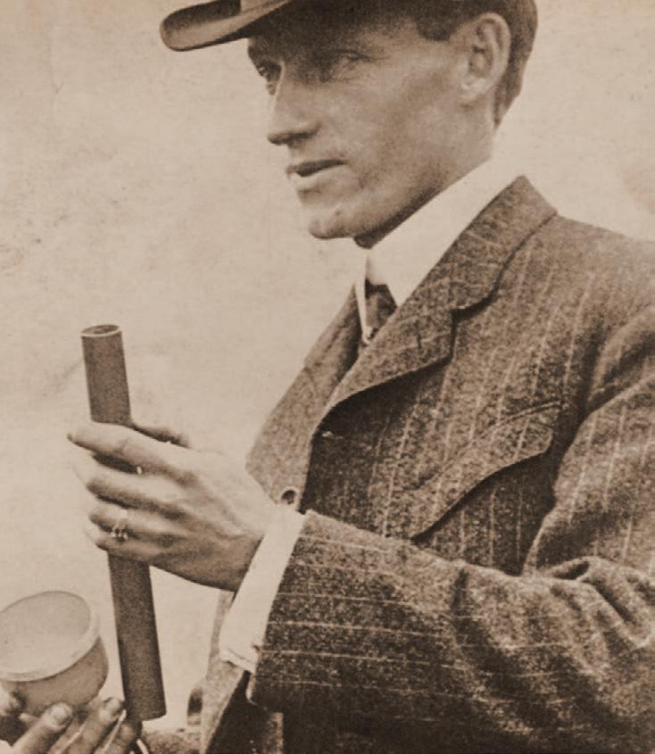
When San Diego was facing a historic drought in 1915, the city council turned to an unlikely character to solve their crisis: Charles Hatfield, a 40-year-old sewing machine salesman and “rainmaker.” For $10,000, the self-styled “moisture accelerator,” vowed to produce enough rain to fill the Morena Dam reservoir within a year. With the city council’s agreement, Hatfield and his brother constructed a 20-foot tower east of the city, topped with a secret mixture of 23 chemicals he claimed would attract rain.

From the Los Angeles Times: “What followed in January and early February of 1916 was a downpour — 30 inches of rain by some estimates. Mission Valley flooded. The San Diego River jumped its banks. Farms, homes, bridges and businesses were swept away. Estimates of the deaths range from a dozen to 50.”

Hatfield claimed he fulfilled the terms of his contract, but the city council refused to pay his $10,000 fee unless he accepted liability for $3.5 million in damages. Hatfield first tried to settle for $4,000, then sued the city council. The legal battle continued for years until the San Diego County Superior Court ruled that the rain was an act of God, releasing Hatfield from liability but forfeiting his fee.
The real rainmaker was an area of high pressure and three Pacific storms that lingered over the region for weeks. And the secret behind Hatfield’s scheme had nothing to do with a mysterious mix of chemicals, but rather his arrival into towns across America, promising rain right at the end of the dry season.
 Charles Hatfield, the rainmaker, checking some equipment. Copyright: Bettmann/Corbis/AP Images.
TOC
The Flood


The Great Flood of 1916 damaged two dams. A third, the Lower Otay Dam on the Otay River, failed on January 27, 1916, sending a 40-foot wall of water racing downstream. More than 100 years later, the devastating effects of the dam failure and the resulting flood are still impacting the area. Thousands of tons of silt, sand, and debris washed downstream, some of which made it all the way into San Diego Bay. From the 1960s to the mid-1980s, mining operations on the Otay River floodplain extracted the sand and gravel left behind, but at the time, there was no requirement for ecological restoration at the site.

Shortly after the Lower Otay Dam failure, in 1918, the City of San Diego reconstructed the dam, renaming it the Savage Dam. Today, the city uses the Lower Otay Reservoir primarily for drinking water, and only occasionally releases water downstream, typically when the reservoir nears its 47,000
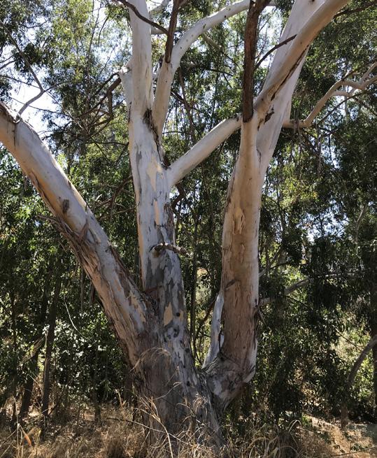
Floodplain Landscape Issues
Top left: invasive eucalyptus
Top right: invasive tamarisk


Bottom left: satellite view of mine tailing strips

Bottom right: mining remnants
acre-feet capacity (about once every 10 years). With the lower Otay Valley disconnected from the rest of the watershed at the dam, the flow is too low for the river to self-repair. The river has no defined channel, even flowing underground in some areas, and cannot naturally move sediment through the floodplain.
The soil of the river valley, disturbed by the historic flooding and years of mining operations, has become prime real estate for invasive plant species to take root. Today, non-native tamarisk dominate the floodplain landscape along with pepper trees, eucalyptus, and palms. With so many factors working against it, it’s no surprise that the natural processes of the Otay River have been significantly altered. To return the area to a naturally functioning ecosystem, the river is in need of a serious restoration effort.
Left: Lower Otay Dam. Image credit: Photo by Unknown, 1916, San Diego History Center.
Middle: Original Earthen Lower Otay Dam and Reservoir. Image credit: Photo by Unknown, 1901, City of San Diego, City Clerk Archives.
Right: Aerial Photograph of 1916 Flood Damage. Image credit: Photo by Unknown, 1916, San Diego History Center.
TOC
The Restoration
Driven by the need to offset planned housing developments, the Otay River Restoration Project (ORRP) kicked off in 2016. The population around San Diego has boomed, and development has been quick to keep pace. HomeFed Corporation, a mixeduse real estate development company, is working with the neighboring landowner City of Chula Vista to restore and use this area as a mitigation bank.

In 2021, HomeFed selected SWCA as the program manager to oversee all aspects of the mitigation lifecycle. Currently, SWCA oversees the design and engineering of the project’s two main components:
1. 2016 Restoration Project: Maintain and monitor more than 38 acres of river, floodplain, and upland restoration in the most upstream portion of the river

2. Mitigation Bank Expansion Project: Restore more than 250 acres of river, floodplain, and upland habitat in an area directly connected to the initial restoration
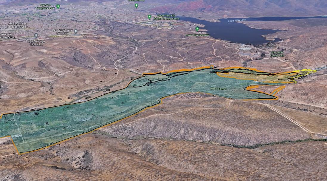
The floodplain restoration in the second area includes creating a braided channel network for better water flow, removing invasive species, and revegetating native riparian and wetland species. In the upland areas, the team is establishing depressional and vernal pools and restoring coastal sage scrub habitat. Over the next year, SWCA will initiate construction oversight, monitoring, reporting, and overall orchestration of the mitigation bank phase of the project, including adaptive management as needed.
What is Mitigation Banking?
Mitigation banking is a legal mechanism whereby ecological improvements are made to areas of need in order to offset ecosystem losses in other places. Successful restoration work creates various types of credits within the mitigation bank,
The Otay River Restoration Project is located in south San Diego County, in the Lower Otay River Watershed, downstream of Savage Dam and Otay Lakes.
“I love big, complex restoration projects like this. Not only because we get to do some of our best work with a strong team across SWCA, but because mitigation projects are really a win-win-win. We leave the local ecosystem better than we found it, the clients are happy because their projects can move forward and they open additional revenue streams, and the community stakeholders benefit from better water quality, a more robust and functional ecosystem, and new opportunities to explore and play in this great part of nature."
Lindsay Teunis, Principal Restoration Ecologist and Project Manager
TOC
Watch the video to see a detailed look into the Otay River Restoration Project.
including credits for aquatic resources and select sensitive species. Similar to an account at a financial bank, HomeFed can save these mitigation bank credits for later projects, spend them as needed for current developments, or sell them to others who need to offset ecosystem losses for their own projects.


For example, some of HomeFed’s restoration work on the ORRP will help create and restore habitat for the least Bell’s vireo (Vireo bellii pusillus), a federally endangered songbird that relies heavily on healthy riparian habitat. If another project elsewhere in the mitigation bank’s identified service area negatively impacts the least Bell’s vireo habitat, that project can purchase credit from HomeFed to offset the habitat loss. This type of exchange is permitted through the various wildlife and aquatic resources agencies, with a minimum of one acre of habitat or territory impacted in exchange for one acre of habitat

restored (although in most cases, regulatory agencies require greater than a 1:1 ratio to offset the impact). By ensuring no net loss across the service area, the vireo is not losing out on valuable habitat.
New project proposals that involve an existing mitigation bank tend to have a leg up with regulators. It’s much more efficient to buy credits from a mitigation bank than to spend the time and resources to create a restoration project from scratch. Similarly, the resource agencies benefit when a bank is available for use because it ensures a level of standard for the restored resources, streamlines the regulatory process, and can create efficiencies in their workflow. SWCA is preparing the final mitigation banking documents and permitting, as well as facilitating agency coordination, marketing credit reservations, and informing the public.
The restoration includes removing invasive species, constructing a new stream course, and reestablishing a resilient ecosystem through the careful planning and planting of native vegetation.
The team introduced 16,000 plants in the most upstream portion of the river. Non-native plants are removed immediately from the project site.
TOC
The Winning Team
Restoring natural habitat is a boon for the plant and animal species that live there, like the least Bell’s vireo (Vireo bellii pusillus), San Diego fairy shrimp (Branchinecta sandiegonensis), California Ridgway’s rail (Rallus obsoletus obsoletus), Quino checkerspot butterfly (Euphydryas editha quino), and a number of other sensitive species in and around the Otay Valley. But the benefits of restoration projects extend far beyond the local ecology.
The City of Chula Vista will be one of the long-term preservation managers of the area, along with San Diego County and the City of San Diego. Because it is being completed on publicly owned land, part of the project includes developing a 5-mile network of multi-use trails within the City of Chula Vista Greenbelt Trail Corridor, a connection to the Otay Valley Regional Park
System, and educational signage. After implementation, hikers, mountain bikers, and equestrians will have easier access to this rural trail network, not something usually found in such close proximity to a coastal urban area.

“With that public access, we hope there will be some educational opportunities too,” said Lindsay Teunis, a San Diego native and SWCA principal restoration ecologist who has worked throughout many phases of the ORRP. “That could look like field trips for K-12 students, college students, even some graduate or Ph.D. candidates who want to do research in the area.”
The restoration area also overlaps with the traditional lands of the Kumeyaay Nation, another key stakeholder in the ORRP. “We’ve been engaging with the Kumeyaay people, in particular at Kumeyaay Community College, to get students involved in

 In the upland area of the Mitigation Bank Expansion Project, the team is establishing depressional and vernal pools and restoring coastal sage scrub habitat.
The team collects quantitative and qualitative data regularly, including surface and subsurface water samples.
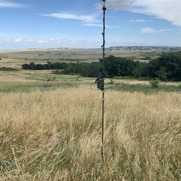
Strategically placed cameras throughout the site monitor local wildlife.
In the upland area of the Mitigation Bank Expansion Project, the team is establishing depressional and vernal pools and restoring coastal sage scrub habitat.
The team collects quantitative and qualitative data regularly, including surface and subsurface water samples.
Strategically placed cameras throughout the site monitor local wildlife.
TOC
preserve management, adaptive management, and use of land. As the original stewards of the land, we want to make sure that they are as involved as possible. The project is at the beginning stages of collaboration with the Kumeyaay, but we are excited and eager for the next steps.”
The ORRP goes above and beyond basic regulatory compliance. “From the beginning, HomeFed has always encouraged a highquality mitigation product, and it’s something I know they are proud of as well,” said Teunis. “Mitigation banking is one of the best uses of private dollars on public land in that, when done properly, the benefit to the public land is a lift, not a burden — and is often done at a cost that is not easily covered by grants or public funding.”
“I love big, complex restoration projects like this,” Teunis added. “Not only because we get to do some of our best work with a strong team across SWCA, but because mitigation projects are really a win-win-win. We leave the local ecosystem better than we found it, the clients are happy because their projects can move forward and they open additional revenue streams, and the community stakeholders benefit from better water quality, a more robust and functional ecosystem, and new opportunities to explore and play in this great part of nature.”
See more details on the Otay River Restoration Project website. For more information, contact Lindsay Teunis.


 Quino checkerspot butterfly (Euphydryas editha quino). Image credit: Susan Wynn/USFWS.
Least Bell’s vireo (Vireo bellii pusillus). Image credit: Western Ecological Research Center (WERC)/USGS.
SWCA Project Restoration Ecologist Marcus Goncalves points out 50-year-old black willows (Salix nigra), mule fat (Baccharis salicifolia), and a variety of native willow saplings and vegetation in an upstream area of the Otay River.
Quino checkerspot butterfly (Euphydryas editha quino). Image credit: Susan Wynn/USFWS.
Least Bell’s vireo (Vireo bellii pusillus). Image credit: Western Ecological Research Center (WERC)/USGS.
SWCA Project Restoration Ecologist Marcus Goncalves points out 50-year-old black willows (Salix nigra), mule fat (Baccharis salicifolia), and a variety of native willow saplings and vegetation in an upstream area of the Otay River.
“The goal of ecosystem restoration is to create a self-sustaining ecosystem — an ecosystem that maintains its resilience long after we ecologists are gone."
TOC
Marcus Goncalves, Project Restoration Ecologist at SWCA, shares the what, why, and how of ecological restoration in this episode of SWCA's Ask an Expert.
PARTING SHOT
Documenting scenic quality for the BLM Winnemucca District office visual resources inventory (VRI). Read more in Seeing Eye to Eye: How Visual Resources Build Consensus on Sustainable Development, page 12.

The Wire is published by SWCA, Incorporated.
Sarah Rambeau | Editor & Writer
Siena Dute, Quinn Zimmerman, Brent McDaniel, Kelli Baker | Writers
Debra Baillie | Graphic Designer & Illustrator
Leon Schatz | Multimedia Editor
For editorial comments or questions, email us at thewire@swca.com
TOC

